Embed Size (px)
Citation preview
1 | P a g e
Mass movement events in the Himalaya: The impact of
landslides on Ladakh, India.
Sian Hodgkins
Geology for Global Development
2 | P a g e
This report was commissioned for charitable purposes, by Geology for Global Development. The report is intended to provide a useful compilation of literature, media and statistics relating to
hazardous mass movements for charities, local authorities or students working in Ladakh or other mountainous regions. No responsibility can be accepted for any errors, mistakes or
inaccuracies, but we would be happy to correct any errors brought to our attention in a second edition.
Licencing and attribution The content on this report is licensed under the Creative Commons Attribution 3.0 licence (CC BY). This means that:
Copyright on any article is retained by the author(s) for the post. The name of a post author is specified in the by-line. Any third party can use the article freely as long as its original authors and citation details are identified. This
includes a link to the post if used in an online publication, or citing www.gfgd.org for print materials, together with the author’s name.
Note that this licence applies to the text in this report. While some images are licensed under Creative Commons, others have been reproduced with permission from the author. Please check the original source for information on how they are licensed before using them. To summarise, this licence means anyone is free to Share (to copy, distribute and transmit the work) and to Remix (to adapt the work), under the following conditions:
Attribution. The original authors and source must be given credit For any reuse or distribution, it must be made clear to others what the license terms of this work are.
3 | P a g e
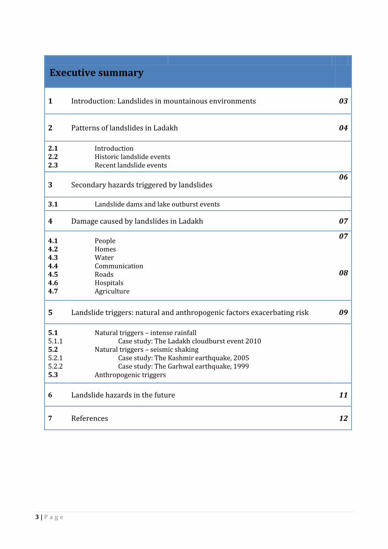
1 Introduction: Landslides in mountainous environments 03
2 Patterns of landslides in Ladakh 04
2.1 2.2 2.3
Introduction Historic landslide events Recent landslide events
3 Secondary hazards triggered by landslides 06
3.1 Landslide dams and lake outburst events
4 Damage caused by landslides in Ladakh 07
4.1 4.2 4.3 4.4 4.5 4.6 4.7
People Homes Water Communication Roads Hospitals Agriculture
07 08
5 Landslide triggers: natural and anthropogenic factors exacerbating risk 09
5.1 5.1.1 5.2 5.2.1 5.2.2 5.3
Natural triggers – intense rainfall Case study: The Ladakh cloudburst event 2010
Natural triggers – seismic shaking Case study: The Kashmir earthquake, 2005 Case study: The Garhwal earthquake, 1999
Anthropogenic triggers
6 Landslide hazards in the future 11
7 References 12
Executive summary

4 | P a g e
Executive Summary
Landslides in Ladakh are caused by changes to slope stability which initiate debris flows and rock falls.
A change in slope stability may be caused by a change to the slope angle, a change to the slope
vegetation (cohesion) or a change in the saturation (pore pressure) of sediment on the hillslopes. The
weathering of the hillslopes in the Ladakh mountain range has formed loose regolith and sediment
which is susceptible to landsliding. Rivers and glacial streams have incised the valleys forming steep
sided slopes. Debris flows, rock falls and mudflow landslides are then triggered either naturally, by
heavy precipitation and earthquakes, or unnaturally, by vibrations from heavy vehicles such as army
trucks or where humans have modified the hillslopes. Debris flows are formed from a mixture of rock,
mud and water which carries trees, boulders and debris. Rock falls occur on steep slopes which have
been undercut by streams or by the construction of roads. Loose rocks and boulders that have become
detached from the slope fall rapidly through the air, which is particularly hazardous on the mountain
passes in Ladakh. Landslides may also form natural dams as they block the course of rivers in Ladakh.
Behind these dams lakes form which may flood the surrounding region when the dam breaches.
Therefore, it is important that the stability of landslide dams in Ladakh is monitored so that hazardous
flooding events can be prevented.
In Ladakh the Kelang Serai, Patseo and Chilam landslide deposits were triggered during periods of
increased monsoon strength. These historic deposits are examples of large landslides that have
occurred in the region. The Darcha landslide (also an historic landslide) was caused by the structure
(bedding and faulting) of the geology, which created lines of weakness along which the slope failed.
In the last decade landslide events in Ladakh have been reported in the media and recorded by
geological organisations such as the United States Geological Survey. These landsliding events have
caused loss of life, injuries and road blockages. The most significant event to have occurred in recent
history was the 2010 cloudburst event. This event was caused by a period of unusually intense
precipitation on the hillslopes which triggered debris flows and mudflows. Over 200 people died in the
event from multiple causes, including by drowning in the mudflows/floods or from head injuries caused
by falling debris. The debris flows also destroyed homes, roads, bridges, the Leh hospital, drinking
water canals, farmland and lines of communication. In 2005 approximately 1000 people died directly
from landslides triggered in a region over 7500km2, by the ‘Kashmir earthquake’ (Owen et al., 2008).
Over half of the landslides studied following the Kashmir earthquake were linked to human activity. The
construction of roads was the most common cause of landsliding as they steepen the slope angle. Other
forms of human activity that can cause landslides include building on fragile slopes, deforestation,
forest fires, terraces built for agriculture and the vibrations caused by construction or vehicles.
Climate change poses a great concern for future risk to landsliding in Ladakh. An increase in global
temperatures may cause an increase in the frequency and magnitude of storm events over the
Himalaya. An increase in intense precipitation in Ladakh will increase the probability of large landslides
in the region. In addition, the expansion of towns and villages in Ladakh as the region develops may
influence the chance of landsliding. Homes built on fragile hillslopes are at a greater risk of landsliding
as they further destabilise the slope and increase the chance of slope failure.
5 | P a g e
1. Introduction: Landslides in mountain environments
The most common forms of landslides in mountain environments are rock falls, debris flows, ice
avalanches and creep. The Ladakh landscape is highly sensitive and susceptible to mass movement
events. Ladakh lies in northern India in the Himalayas, southwest of the Tibetan Plateau. The region is
shadowed from the Indian summer monsoon by high elevation areas of the Himalaya to the south and
the Karakoram mountain range to the north; both act as orographic barriers, creating an arid
environment (Bookhagen et al., 2005). Consequently, the Leh valley only receives on average 41mm of
precipitation between June and September, which is delivered by the southwest monsoon, and an
average of 53mm of precipitation between October-May delivered by the incoming Westerlies (Sant et
al., 2011). Therefore, climate is the main control on the frequency and magnitude of mass movement
events in Ladakh.
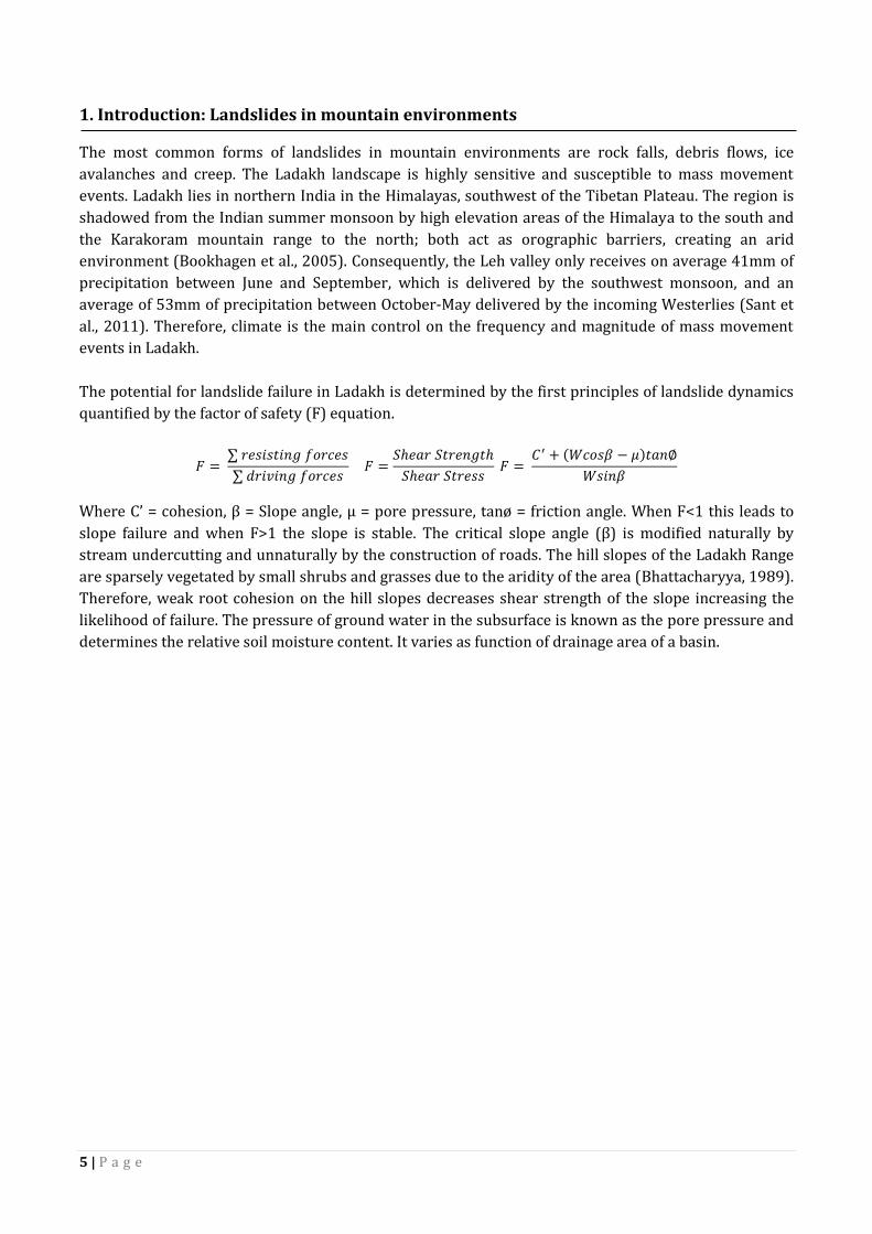
The potential for landslide failure in Ladakh is determined by the first principles of landslide dynamics
quantified by the factor of safety (F) equation.
𝐹 = ∑ 𝑟𝑒𝑠𝑖𝑠𝑡𝑖𝑛𝑔 𝑓𝑜𝑟𝑐𝑒𝑠
∑ 𝑑𝑟𝑖𝑣𝑖𝑛𝑔 𝑓𝑜𝑟𝑐𝑒𝑠 𝐹 =
𝑆ℎ𝑒𝑎𝑟 𝑆𝑡𝑟𝑒𝑛𝑔𝑡ℎ
𝑆ℎ𝑒𝑎𝑟 𝑆𝑡𝑟𝑒𝑠𝑠 𝐹 =
𝐶′ + (𝑊𝑐𝑜𝑠𝛽 − 𝜇)𝑡𝑎𝑛∅
𝑊𝑠𝑖𝑛𝛽
Where C’ = cohesion, β = Slope angle, μ = pore pressure, tanø = friction angle. When F<1 this leads to
slope failure and when F>1 the slope is stable. The critical slope angle (β) is modified naturally by
stream undercutting and unnaturally by the construction of roads. The hill slopes of the Ladakh Range
are sparsely vegetated by small shrubs and grasses due to the aridity of the area (Bhattacharyya, 1989).
Therefore, weak root cohesion on the hill slopes decreases shear strength of the slope increasing the
likelihood of failure. The pressure of ground water in the subsurface is known as the pore pressure and
determines the relative soil moisture content. It varies as function of drainage area of a basin.
6 | P a g e
2. Pattern of landslides in Ladakh
2.3 Introduction
The geomorphology of the Leh valley basin is determined by the mechanics of erosion and deposition
acting in a paraglacial environment. The Indus River flows through the Leh Valley, separating the
Zanskar Range to the south and the Ladakh Range to the north. Glaciers have formed in cirques on the
northern slopes of the Ladakh Range in the snow accumulation zone above ~5100 m (Jamieson et al.,
2004). For the last 130,000 years retreat of the glaciers in the Leh Valley has dominated mass wasting
events in the Ladakh region. At altitudes above ~4800m the slopes undergo large variations in
temperature, which causes frost shattering of the rocks and produces unconsolidated sediment and
debris (Jamieson et al., 2004). As both the Zanskar and Ladakh Ranges are situated in a climatically
sensitive zone, the hill slopes consist of unconsolidated clasts created by the mechanical weathering of
the Ladakh batholith and Zanskar metasediments (Sant et al., 2011). This material is the primary
constituent of landslides in the Leh Valley and is transported downslope by meltwater from the glaciers,
by the glaciers themselves or by the process of creep (Sant et al., 2011). Significant deglaciation of the
valley from ~30Ka to present day has produced glacial streams forming fluvial terraces and floodplains
in the Ladakh Range (Pant et al., 2005). These fluvial processes have incised the Leh Valley and formed
the River Indus which, coupled with rapid tectonic uplift, has produced steep sided “V” shaped valleys
and gullies. A combination of steep slope angles and poor root cohesion on these un-vegetated
hillslopes means that the Ladakh valley is highly susceptible to landsliding in the form of rock falls,
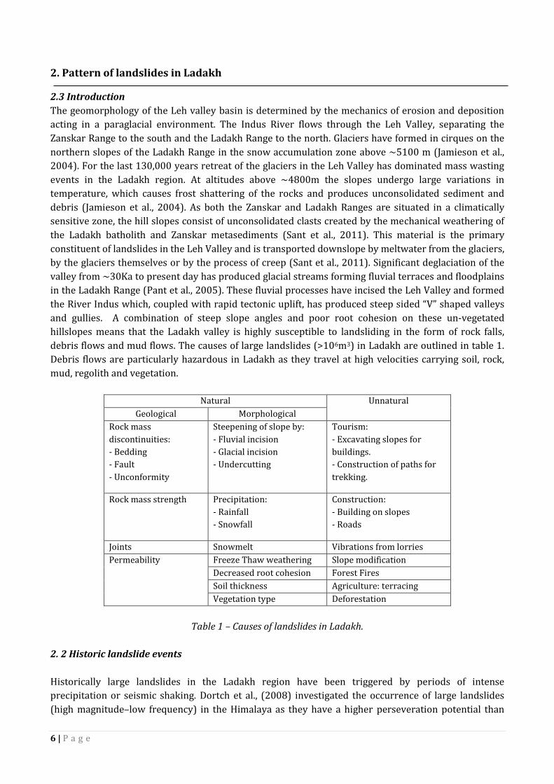
debris flows and mud flows. The causes of large landslides (>106m3) in Ladakh are outlined in table 1.
Debris flows are particularly hazardous in Ladakh as they travel at high velocities carrying soil, rock,
mud, regolith and vegetation.
Natural Unnatural
Geological Morphological
Rock mass
discontinuities:
- Bedding
- Fault
- Unconformity
Steepening of slope by:
- Fluvial incision
- Glacial incision
- Undercutting
Tourism:
- Excavating slopes for
buildings.
- Construction of paths for
trekking.
Rock mass strength Precipitation:
- Rainfall
- Snowfall
Construction:
- Building on slopes
- Roads
Joints Snowmelt Vibrations from lorries
Permeability Freeze Thaw weathering Slope modification
Decreased root cohesion Forest Fires
Soil thickness Agriculture: terracing
Vegetation type Deforestation
Table 1 – Causes of landslides in Ladakh.
2. 2 Historic landslide events
Historically large landslides in the Ladakh region have been triggered by periods of intense
precipitation or seismic shaking. Dortch et al., (2008) investigated the occurrence of large landslides
(high magnitude–low frequency) in the Himalaya as they have a higher perseveration potential than

7 | P a g e
small landslides (low magnitude–high frequency). The study analysed and dated four large landslides in
Lahul and Ladakh that occurred during the Holocene, around 2000 years after deglaciation. They were
compared to twelve landslides that had been previously dated, to establish the causes that make the
slopes susceptible to land sliding and the triggers that initiate slope failure. Details of the four
landslides studied are summarised in Table 2. The Kelang Serai, Patseo and Chilam landslides were
likely to have been caused by an increased in pore water pressure over a period of increased monsoon
strength (Bookhagen et al., 2005). However, they suggest that the Kelang Serai landslide was caused by
undercutting of the slope or by changes in the shear strength of the slope (Mitchell et al., 2005). All
these landslides occurred after deglaciation and therefore, as well as intense rainfall, they may also
have been triggered by seismic shaking. Dortch et al., (2008) determined that the Darcha landslide was
likely to have been initiated by “gravitationally induced buckling” of the steeply dipping rock mass
discontinuities. This is because it does not coincide with a recorded period of intense monsoon
strength.
Table 2 –Examples of four historic landslides in the Ladakh region.
2.3 Recent landslide events
In the last decade there have been a number of recorded landslide events in Ladakh. There is no official
record of every event and so the list compiled in Table 3 is from media reports and the USGS landslides
hazard programme (Web USGS). However, the recorded cases are likely to be events where people have
been injured, killed or where there have been disruptions to major roads.
Year Location Description Injured Dead Source
August, 2013 Road at Chang La on the way to Pangong Tso
Rockfall caused roadblock. 0 0 Web I
May,2013 National Highway Landslide caused roadblock. 0 0 Web II
July, 2012 Durbuk–Pass, Ladakh Landslide 400 tourists
0 Web III and IV
August, 2010 Leh Cloudburst Event ~ 400 ~179-500 Web V
December, 2007 15th December Landslide
Landslide - No reported trigger 6 2 (military)
Web VI
October, 2005 Kashmir Earthquake on Pakistan/Indian border. Triggered landslides and mudslides.
6,266 (Jammu and Kashmir)
~865 – 1350 (India)
Web VII and VIII
Table 3 – Examples of recent landslides in Ladakh.
Landslide Deposit Darcha Patseo Kelang Serai Chilam
Age (ka) 7.7±1.0 7.9 ± 0.8 6.6±0.4 8.5 ± 0.5
Surface area (m2) 0.2x10⁶ m2 1.7 x10⁶ m2 5.2 x10⁶ m2 3.2 x10⁶ m2
Debris volume (m3) 10,000,000 127,500,000 520,000,000 240,000,000
Trigger Gravitationally-
induced
buckling
Increased
pore water
pressure
Increased pore
water pressure
Increased
pore water
pressure
8 | P a g e
3. Secondary hazards triggered by landslides.
In mountain regions landslides can cause further natural hazards such as flooding. Landsliding in
Himachal Pradesh and Jammu and Kashmir has blocked river valleys, creating naturally dammed lakes.
The following section looks at a historic paleolake outburst event in Leh and the 1871 great Indus flood
in Pakistan.
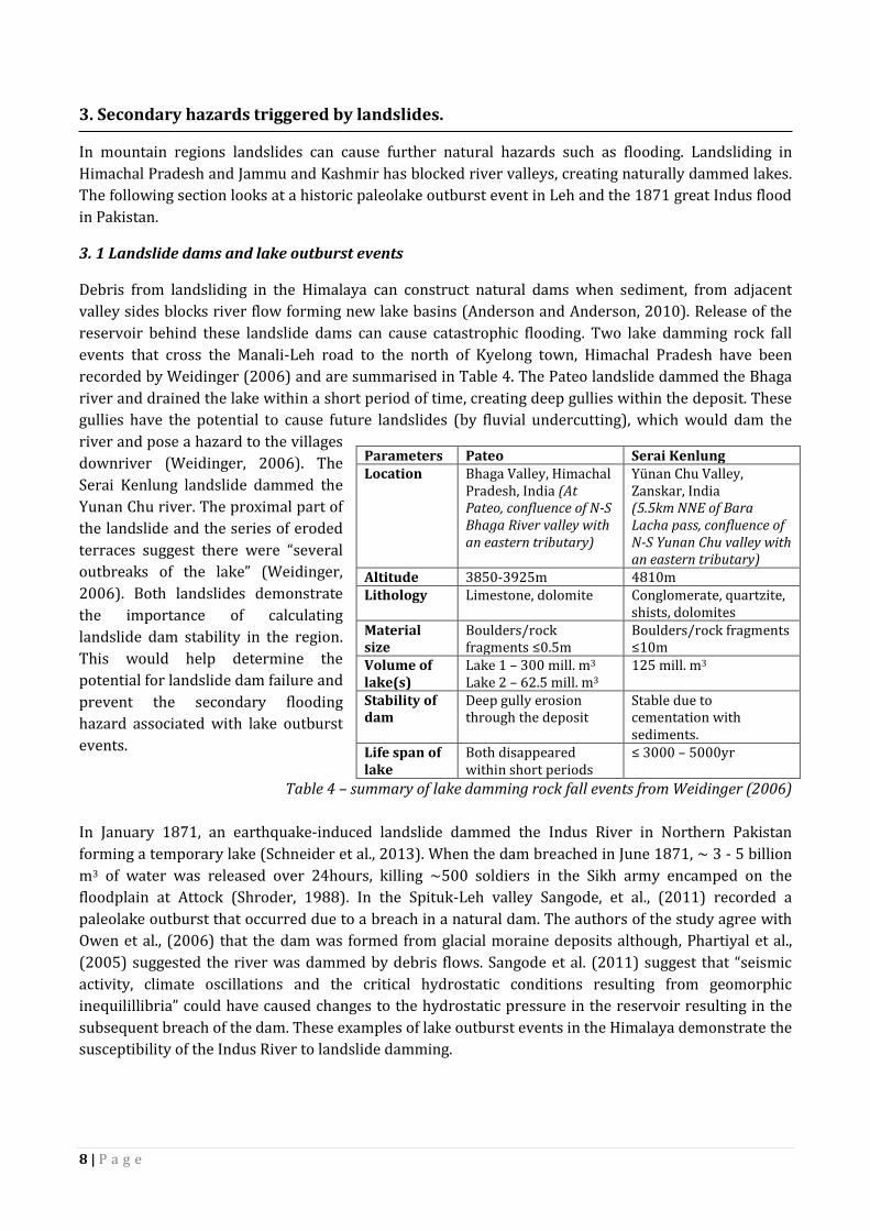
3. 1 Landslide dams and lake outburst events
Debris from landsliding in the Himalaya can construct natural dams when sediment, from adjacent
valley sides blocks river flow forming new lake basins (Anderson and Anderson, 2010). Release of the
reservoir behind these landslide dams can cause catastrophic flooding. Two lake damming rock fall
events that cross the Manali-Leh road to the north of Kyelong town, Himachal Pradesh have been
recorded by Weidinger (2006) and are summarised in Table 4. The Pateo landslide dammed the Bhaga
river and drained the lake within a short period of time, creating deep gullies within the deposit. These
gullies have the potential to cause future landslides (by fluvial undercutting), which would dam the
river and pose a hazard to the villages
downriver (Weidinger, 2006). The
Serai Kenlung landslide dammed the
Yunan Chu river. The proximal part of
the landslide and the series of eroded
terraces suggest there were “several
outbreaks of the lake” (Weidinger,
2006). Both landslides demonstrate
the importance of calculating
landslide dam stability in the region.
This would help determine the
potential for landslide dam failure and
prevent the secondary flooding
hazard associated with lake outburst
events.
Table 4 – summary of lake damming rock fall events from Weidinger (2006)
In January 1871, an earthquake-induced landslide dammed the Indus River in Northern Pakistan
forming a temporary lake (Schneider et al., 2013). When the dam breached in June 1871, ~ 3 - 5 billion
m3 of water was released over 24hours, killing ~500 soldiers in the Sikh army encamped on the
floodplain at Attock (Shroder, 1988). In the Spituk-Leh valley Sangode, et al., (2011) recorded a
paleolake outburst that occurred due to a breach in a natural dam. The authors of the study agree with
Owen et al., (2006) that the dam was formed from glacial moraine deposits although, Phartiyal et al.,
(2005) suggested the river was dammed by debris flows. Sangode et al. (2011) suggest that “seismic
activity, climate oscillations and the critical hydrostatic conditions resulting from geomorphic
inequilillibria” could have caused changes to the hydrostatic pressure in the reservoir resulting in the
subsequent breach of the dam. These examples of lake outburst events in the Himalaya demonstrate the
susceptibility of the Indus River to landslide damming.
Parameters Pateo Serai Kenlung Location Bhaga Valley, Himachal
Pradesh, India (At Pateo, confluence of N-S Bhaga River valley with an eastern tributary)
Yünan Chu Valley, Zanskar, India (5.5km NNE of Bara Lacha pass, confluence of N-S Yunan Chu valley with an eastern tributary)
Altitude 3850-3925m 4810m Lithology Limestone, dolomite Conglomerate, quartzite,
shists, dolomites Material size
Boulders/rock fragments ≤0.5m
Boulders/rock fragments ≤10m
Volume of lake(s)
Lake 1 – 300 mill. m3 Lake 2 – 62.5 mill. m3
125 mill. m3
Stability of dam
Deep gully erosion through the deposit
Stable due to cementation with sediments.
Life span of lake
Both disappeared within short periods
≤ 3000 – 5000yr
9 | P a g e
4. Damage caused by landslides in Ladakh
Landslides in Ladakh have not only killed and injured people but they have also cause damage to the
infrastructure which connects remote villages and army bases in the region.
4.1 People
The most well documented case on loss of life due to landsliding in Ladakh is from the 2010 cloudburst
event. Cause of death was most commonly drowning in floodwaters, being buried alive in the mudflows,
head injuries from falling debris, haemorrhage from open wounds and exacerbation of underlying
medical conditions (Rashid et al., 2012). The landslides in 2010 have also caused many “bruises,
abrasions and laceration” injuries.
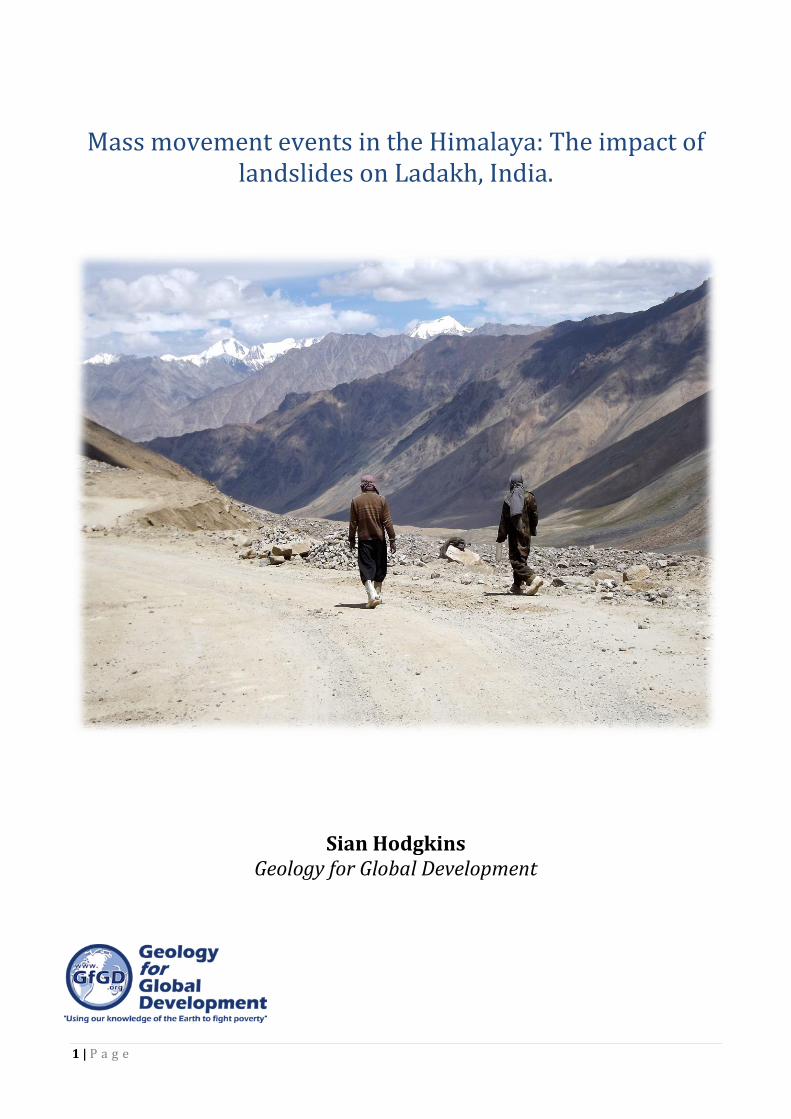
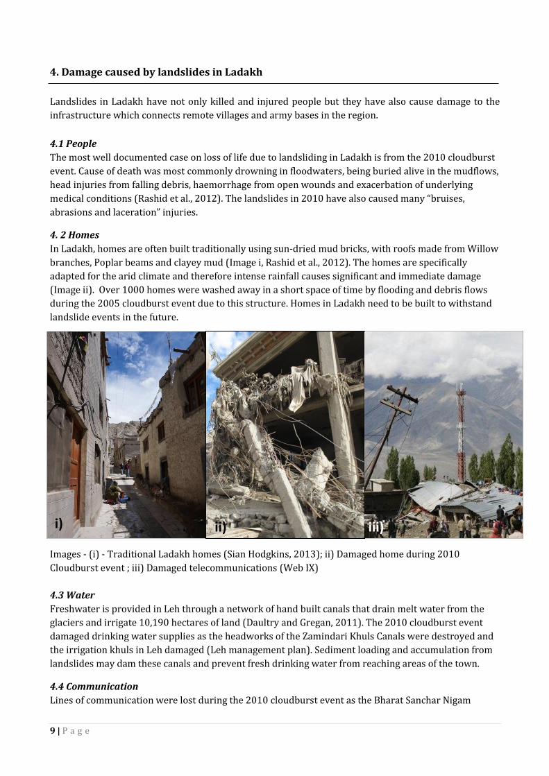
4. 2 Homes
In Ladakh, homes are often built traditionally using sun-dried mud bricks, with roofs made from Willow
branches, Poplar beams and clayey mud (Image i, Rashid et al., 2012). The homes are specifically
adapted for the arid climate and therefore intense rainfall causes significant and immediate damage
(Image ii). Over 1000 homes were washed away in a short space of time by flooding and debris flows
during the 2005 cloudburst event due to this structure. Homes in Ladakh need to be built to withstand
landslide events in the future.
Images - (i) - Traditional Ladakh homes (Sian Hodgkins, 2013); ii) Damaged home during 2010
Cloudburst event ; iii) Damaged telecommunications (Web IX)
4.3 Water
Freshwater is provided in Leh through a network of hand built canals that drain melt water from the
glaciers and irrigate 10,190 hectares of land (Daultry and Gregan, 2011). The 2010 cloudburst event
damaged drinking water supplies as the headworks of the Zamindari Khuls Canals were destroyed and
the irrigation khuls in Leh damaged (Leh management plan). Sediment loading and accumulation from
landslides may dam these canals and prevent fresh drinking water from reaching areas of the town.
4.4 Communication
Lines of communication were lost during the 2010 cloudburst event as the Bharat Sanchar Nigam
i) ii) iii)
10 | P a g e
Limited (BSNL) Telecom was washed away as well as the local radio station (Image iii, Leh disaster
management plan). During a natural disaster the loss of a mobile network can significantly hinder the
relief efforts.
4.5 Roads
Landslides in Ladakh cause road blockages on the high altitude mountain passes throughout the year. In
the winter months the region is completely cut off by snowfall on these mountain roads and therefore
landslides can prolong road blockages making them a problem throughout the year. During the 2010
cloud burst event 26 roadways (688.80 km) were damaged in Leh district, which accounted for 40% of
all roadways. Of this 662.34 km of roads were under floodwaters and sludge. Of the bridges 29 in the
region were damaged and 10 of these were completely washed away (Leh management plan).
4.6 Hospitals
The Sonam Norboo Memorial hospital (SNM) in Leh was also damaged during the 2010 cloudburst
event with the heating system destroyed as well as the operating theatre, surgical warms, medical
wards, labour room, OPD and the C.T scan (Leh disaster management plan).
4.7 Agriculture
Ladakh is supported by nomadic subsidence farming creating a terraced landscape (Daultrey and
Gergan, 2011). In the 2010 landslides, farmland was covered under mudslides destroying valuable
crops and damaging the irrigation network.
11 | P a g e
5. Landslide triggers: Natural and anthropogenic factors exacerbating risk
Landslides in mountain regions are triggered by both natural and anthropogenic disturbances that
initiate slope failure. The most common natural landslide triggers in Ladakh are (i) an increase in the
intensity of rainfall and (ii) seismic shaking caused by earthquakes (Dortch, et al., 2008). The following
case studies describe two different events in the last decade that have triggered land sliding in Ladakh.
5. 1 Natural triggers – Intense rainfall
The strength of the Indian monsoon determines the intensity of precipitation events in the Himalaya.
Changes in the intensity of the southwest monsoon, during years of strengthened atmospheric
circulation correspond to an increase in the number of large landslides (>0.5 km3) in the Late
Pleistocene and Holocene periods (Bookhagen et al., 2005 and Dortch et al., 2008).
The Ladakh Cloudburst event, 2010
The most devastating landsliding event to occur in Ladakh in recent history was triggered by an
abnormal period of intense rainfall known as a cloudburst event. On the 6th August 2010 the Ladakh
Range experienced two hours of concentrated precipitation which reached a peak intensity of ~75mm
of rainfall over a thirty minute period (Hobley et al., 2013). The event was caused by 500mb winds and
a series of mesoscale convection systems which developed to the East of Leh and caused a localised
cloud burst (Indian MET Department, 2010). A report by the American Meteorological Survey describes
the weather conditions prior to the cloudburst event in detail and includes satellite images of the storm
(Rasmussen and Houze, 2012). The Indian Air Force recorded 250mm of rainfall over one hour at Leh
airport. Ladakh normally receives ~15 mm of rain in August and the highest ever single rainfall event
recorded was 51.3mm over twenty four hours on 22nd August, 1933 (Daultrey and Gergan, 2011,
Indian MET Department, 2010). The intense rainfall caused loose sediment on the hillslopes to reach
critical saturation levels initiating slope failure. Subsequently, mudflows and debris flows accumulated
boulders, trees and building debris as they travelled towards the Indus river. A debris flow from
Choglamsar reached 2km in width and travelled 10km, whilst the debris flow in Leh travelled 3km from
source through the town (Daultrey and Gergan, 2011). The death toll for the disaster varies within the
literature and media with the majority of reports stating 200 people died; 179 reported dead by Rashid
et al (2012) and ~600 reported dead in a paper by Hobley et al., (2013). The discrepancy in this figure
could be due to the remoteness of the villages in Ladakh and lack of communication during the disaster.
The Leh disaster management plan states that over 200 lives were lost in Leh, Choglamsar, Saboo and
Phyang (Leh disaster management plan, 2011). Following the floods the BBC reported the day after the
disaster that officials has estimated “80% of Ladakh's infrastructure [was] partially damaged or totally
destroyed” by flooding and mudflows and there was more than 150 million USD worth of damages to
buildings and infrastructure (WEB BBC, Parkash, 2012). As well as impacting the local community,
tourists who were in the region for the short summer trekking season were also caught in the debris
flows. Hundreds of tourists were stranded on the Skiu-Markha trekking route and in the Wanla and
Rumste regions (Leh disaster management plan, 2011). One group of trekkers caught in the Markah
Valley sheltered in a hill top village without any communication until they were rescued on the 8th
August (Web X).
5.2 Natural triggers – Seismic shaking
Earthquakes are another natural trigger of landslides in Ladakh and cause mass movement events in
the form of debris falls and rock avalanches (Barnard et al., 2001). The 2005 earthquake in Kashmir,

12 | P a g e
Pakistan was felt up to 1,000 km away including in Delhi and caused the death of at least 1350 people in
Jammu and Kashmir and injured ~6,266 people in the state (Web encyclopaedia). The 1999 Garhwal,
India earthquake occurred east of Ladakh and triggered localised landsliding. Both case studies
demonstrate the susceptibility of Ladakh to earthquake induced landslides. Keefer (1994) and Owen et
al., (2008) have suggested that a threshold (~7.5 moment magnitude) exists on the magnitude of
earthquake needed in the Himalaya to initiate “widespread landsliding” and large landslides. There is
evidence to suggest that 7.5 M earthquakes in the Himalaya may have occurred in the past during
strengthened monsoon periods, having a cumulative effect on the triggering of landslides in Ladakh.
The Kashmir earthquake, 2005
In neighbouring Pakistan, Owen et al., (2008) studied landslides triggered by the 2005 earthquake. The
7.7 Ms magnitude earthquake triggered thousands of landslides which directly caused ~1000 deaths.
Out of the 1293 landslides analysed in the study, 90.1% were rock falls or debris falls and at 53% of the
sites human activity had contributed to slope failure. The debris analysed was very fragmented
suggesting that the landslides travelled at speeds around ~10 m/s. Of the sites where failure was linked
to human activity, the construction of roads on slopes >50° was the most common cause of the
landslides. Following the earthquake, in 2006 the monsoon season triggered further debris flows and
flooding caused by fissures produced in 2005. The authors suggest that because the Kashmir
earthquake mobilised a greater volume of material, than the Garhwal earthquake, this is further
evidence that a critical magnitude threshold exists for large landslide events in the region (Owen et al.,
2008).
The Garhwal earthquake, 1999
In 1991 (Ms 7.1) and 1999 (Ms 6.6) earthquakes hit the Himalayas in Garhwal, India. Barnard et al.,
(2001) studied 56 landslides triggered by the 1999 earthquake and 282 other landslide deposits caused
by both natural and human factors. Like the Kashmir landslides the mass movement events following
the Garhwal earthquake were in the form of debris and rock falls. Debris flows were associated with
non-earthquake induced landslides. However, the study concluded that human activity had contributed
to or directly initiated two thirds of the landslides investigated which suggests the increased likelihood
of human induced landslides in Ladakh.
5. 3 Anthropogenic triggers
Human activity in Ladakh has modified the hillslopes and resulted in the triggering of landslides.
Anthropogenic disturbances from construction, deforestation, lorry vibrations, road and path
construction, forest fires, agriculture and terraces contribute to slope failure (Barnard et al., 2001). The
construction of roads decreases slope angle and slope cohesion by cut and fill and removal of toe slopes
(Barnard et al., 2001). This involves excavating notches into the weathered bedrock on one side [of the
road] and using the excavated material as fill to support the opposite side of the road (Owen et al.,
2008). Following the Kashmir earthquake in 2005, slopes with an angle >50° failed, causing landslides
across the roads (Owen et al., 2008). It was noted by Owen et al., (2008) that failure also occurred along
the road margins due to poorly compacted fill when the roads were first constructed. Undercutting of
the slopes in Ladakh also occurs during the construction of footpaths and terraces that increase the
angle of the hillslopes.

13 | P a g e
6. Landslide hazards in the future
Landslides pose an imminent and very real threat to the people of Ladakh. The 2010 cloudburst event
demonstrated the devastation that debris flows and mudflows can cause in a very short space of time.
Climate change will have the greatest influence on the frequency and magnitude of future landslide
events. Increasing global temperatures will affect the “capacity of air to hold moisture”, leading to an
increase in the occurrence of storm events with high levels of precipitation and greater wind speeds
(Stoffel and Huggel, 2012, Sat and Litt, 2013). The tectonically active nature of the Himalayas
contributes to the creation and movement of sediment. This generation of sediment means that
sediment supply does not act as a limiting factor landslide frequency in the region. Therefore, the
landscape can be described as being in a state of dynamic equilibrium as it is self-regulating and self-
adjusting, through the mechanisms of negative feedback. Ahnert (1994) suggests that the presence of
inherited landforms (e.g. moraine and U-shaped valleys) that formed during the last period of glaciation
in Ladakh, indicate that the landscape has not yet reached a steady state (where this is no net change of
mass in the landscape, independent of time). Oscillations in climate prevent the landscape from
reaching this steady state equilibrium. In the Late Cenozoic, increased storm events were linked to an
increase in mass movement events and an increase in sediment accumulation (Molnar, 2004). Molnar,
(2004) suggests that global climate instability is more effective at removing sediment than climate
stability. In Ladakh, future debris flows “have the potential to become larger...but not necessarily more
frequent” (Stoffel and Huggel, 2012). This is because, in general, increasing global temperatures will
increase the probability of large (>106m3) landslides in mountain environments as permafrost becomes
less stable (Huggel, 2009).
The fragility of the Ladakh region is not only going to be influenced by climate change, but also by the
expansion of settlements and an increase in tourism. The construction of homes and hotels on the
fragile slopes exposes the population of Ladakh to the risk of landsliding (Sati and Litt, 2013). An
increase in construction in the region destabilises slopes, and the associated vibrations can act as a
trigger. Oberoi and Thakur, (2005) used GIS modelling to generate landslide hazard maps of the Manali-
Leh road which could be used in the future to help planners predict road blocks from landslides. Similar
studies in the region would be invaluable in preparing for future natural hazard events. However, the
uncertainty over the future effects of climate change on landsliding in the region “does not constitute a
case for inaction” in Ladakh (Sati and Litt, 2013). Hazard zonation mapping and risk planning will be
essential in protecting the population of Ladakh from future debris flows and rockfall events.

14 | P a g e
7. References Anderson and Anderson, 2011. Global Geomorphology
Barnard, P, L., et al. 2001. Natural and human-induced landsliding in the Garhwal Himalaya of northern India. Geomorphology, 40. pp. 21–35. Bhattacharyya, A. 1989. Vegetation and climate during the last 30,000 years in Ladakh. Palaeogeography, Palaeoclimatology, Palaeoecology, 73. pp 25–38. Bookhagen, B., Thiede, C, R., Strecker, M, R. 2005. Late Quaternary intensified monsoon phases control landscape evolution in the northwest Himalaya. Geology, 33 (2). pp 149 – 152. Daultrey and Gergan, 2011. Living with Change: adaptation and innovation in Ladakh. Our Planet. Disaster Management Plan Leh District 2011-2012 (Angchok, T. 2011). Dortch, J, M., et al. 2008. Nature and timing of large landslides in the Himalaya and Transhimalaya of northern India. Quaternary Science Reviews. pp 1–18 Hobley, D, E, J., Sinclair, H, D., Mudd, S, M. 2012. Reconstruction of a major storm event from its geomorphic signature: The Ladakh floods, 6 August 2010. Geology, 40 (6). pp 483 – 486. Huggel, C. 2009. Recent extreme slope failures in glacial environments: Effects of thermal perturbation. Quaternary Science Reviews, 28. pp 1119–1130. Indian MET Department, 2010 Jamieson, S, S, R., et al. 2004. Tectonic forcing of longitudinal valleys in the Himalaya: morphological analysis of the Ladakh Batholith, North India. Geomorphology, 58. pp. 49-65.
Mitchell, W, A et al. 2005. Age of the Keylong Serai rock avalanche, NW Indian Himalaya. Geophysical Research Abstracts, 7. Oberoi, S, V., & Thakur, N, K. 2005. Disaster preparedness in the hills: Natural hazard modelling using GIS and remote sensing. In: Proc., Int. Conf. on Computing in Civil Engineering. Owen L, A., et al., 2006. Tectonic forcing of longitudinal valleys in the Himalayas: Morphological analysis of the Ladakh Batholith, North India. Geomorphology, 58. pp 49-65. Owen L, A., et al., 2008. Landslides triggered by the 8 October 2005 Kashmir earthquake. Geomorphology, 94. pp 1–9 Pant, R, K., Phadtare, N, R., Chamyal, L, S., Juyal, N. 2005. Quaternary deposits in Ladakh and Karakoram Himalaya: A treasure trove of the palaeoclimate records. Current Science, 88 (11). pp 1789 – 1798. Parkash, S. 2012. Ethics in disaster management. Annals of Geophysics, 55 (3). pp 383-387 Rashid, A, F., Kaur, B., Aggarwal, O, P. 2012. Leh Cloudburst and its Medico-legal implications. JK – Practitioner, 17 (1-3). pp 76-79. Rasmussen, K, L., Houze, R, A. 2012. A Flash-Flooding Storm at the Steep Edge of High Terrain: Disaster in the Himalayas. Bulletin American Meteorological Society, 93. pp 1713–1724.

15 | P a g e
Sangode, S, J., et al. 2011. A record of lake outburst in the Indus valley of Ladakh Himalaya, India. Current Science, 100 (11). pp 1712 – 1718. Sant, D, A., 2011. Morphostratigraphy and Palaeoclimate Appraisal of the Leh Valley, Ladakh Himalayas, India. Journal Geological Society of India, 77. pp 499 – 510. Sati, V, P., and Litt, D. 2013. Climate Disasters in the Himalaya: Risk and Vulnerability. Mountain Hazards. Schneider et al., 2013. Impact of Large Landslides, Mitigation Measures. Italian Journal of Engineering Geology and Environment, 6. pp 73 – 84. Shroder J, F. 1998. Slope failure and denudation in the western Himalaya. Geomorphology, 26 (1-3). pp 81-105. Stoffel, M and Huggel, C. 2012. Effects of climate change on mass movements in mountain environments. Progress in Physical Geography, 36 (3). pp 421 – 439. Weidinger, J, T. 2006. Landslide dams in the high mountains of India, Nepal and China – Stability and life span of their dammed lakes. Italian Journal of Engineering Geology and Environment, 1. pp 67 – 80. Web references Web BBC - http://www.bbc.co.uk/news/world-south-asia-10937196 Web USGS - http://landslides.usgs.gov/recent/ Web encyclopaedia - http://www.britannica.com/EBchecked/topic/1483628/Kashmir-earthquake-of-2005 Web I - http://www.youtube.com/watch?v=IQap9dZpwwQ Web II - http://freepresskashmir.com/kashmir-leh-highway-closed-due-to-landslides-094526/ Web III - http://www.ndtv.com/article/others/around-400-tourists-stranded-in-ladakh-landslide-240703 Web IV - http://ibnlive.in.com/news/landslide-hits-ladakh-army-rescues-400-people/270041-3.html Web V - http://www.ncmrwf.gov.in/ncmrwf/Cloudburst_Investigation_Report.pdf Web VI http://articles.timesofindia.indiatimes.com/2007-12-17/india/27965181_1_landslide-leh-army-hospital Web VII - http://www.geotimes.org/oct05/WebExtra101005.html Web VIII - http://reliefweb.int/report/pakistan/kashmir-earthquake-october-8-2005-impacts-pakistan
Web IX - http://ahmadalikarim.wordpress.com/2010/08/page/2/) Web X - http://www.smh.com.au/travel/travel-news/terrified-trekkers-recount-hell-in-himalayas-20100813-12270.html