Embed Size (px)
Citation preview

11
Instituto Superior de Estatística e Gestão de InformaçãoUniversidade Nova de Lisboa
Master of Science in Geospatial Master of Science in Geospatial TechnologiesTechnologies
GeostatisticsGeostatisticsCarlos Alberto FelgueirasCarlos Alberto Felgueiras
[email protected]@dpi.inpe.br
[email protected]@isegi.unl.pt
September 20, 2007September 20, 2007

22
PresentationPresentationCarlos Alberto FelgueirasCarlos Alberto Felgueiras
[email protected]@dpi.inpe.br
•• Bachelor in Electronic Bachelor in Electronic EngeneeringEngeneering (UNICAMP)(UNICAMP)
•• MsCMsC in Applied Computation (Digital Terrain Modeling in Applied Computation (Digital Terrain Modeling --INPE)INPE)
•• PhD in Applied Computation (Uncertainties using PhD in Applied Computation (Uncertainties using Indicator Geoestatistical Approaches Indicator Geoestatistical Approaches -- INPE)INPE)
•• Manager of the development of the SPRING project Manager of the development of the SPRING project (Image Processing Division (Image Processing Division –– INPE)INPE)
Brazilian National Institute for Space Researches
Master of Science in Geoespatial Technologies

Master of Science in Geoespatial Technologies
Geostatistics Geostatistics –– Program of the courseProgram of the course
1. Introduction, Initial Concepts and Motivation ( 20/09 )
2. Exploratory Data Analysis (EDA/ESDA) (27/09 and 04/10)
i. Univariate Description
ii. Bivariate Description
iii. Spatial Description
iv. Spatial Continuity Analysis (Variograms)
v. Spatial Isotropy/Anisotropy
3. Deterministic Estimation Procedures (DEP) (11/10)
i. Triangulation (TIN)
ii. Local Sample Mean
iii. Inverse Distance Methods (IDW)
iv. Examples
v. Problems with DEPs 33
Master of Science in Geoespatial Technologies
Geostatistics Geostatistics –– Program of the courseProgram of the course
4. Linear Geoestatistical Estimation (18/10)
i. Simple, Ordinary and Universal Kriging
ii. Cokriging
iii. Validation and CrossValidation
iv. Advantages of using Geoestatistical Estimation
v. Examples
5. Stochastic Simulation and Cosimulation (25/10)
6. Indicator Geostatistical Approaches (continuous and categorical information) (08, 15 and 22/11)
i. Indicator Estimation for continuous variables (C.V.)
ii. Assessment of Local Uncertainties for C.V.s
iii. Indicator Estimation for Discrete Variables (D.V.)
iv. Assessment of Local Uncertainties for D.V.s 44
Master of Science in Geoespatial Technologies
Geostatistics Geostatistics –– Program of the courseProgram of the course
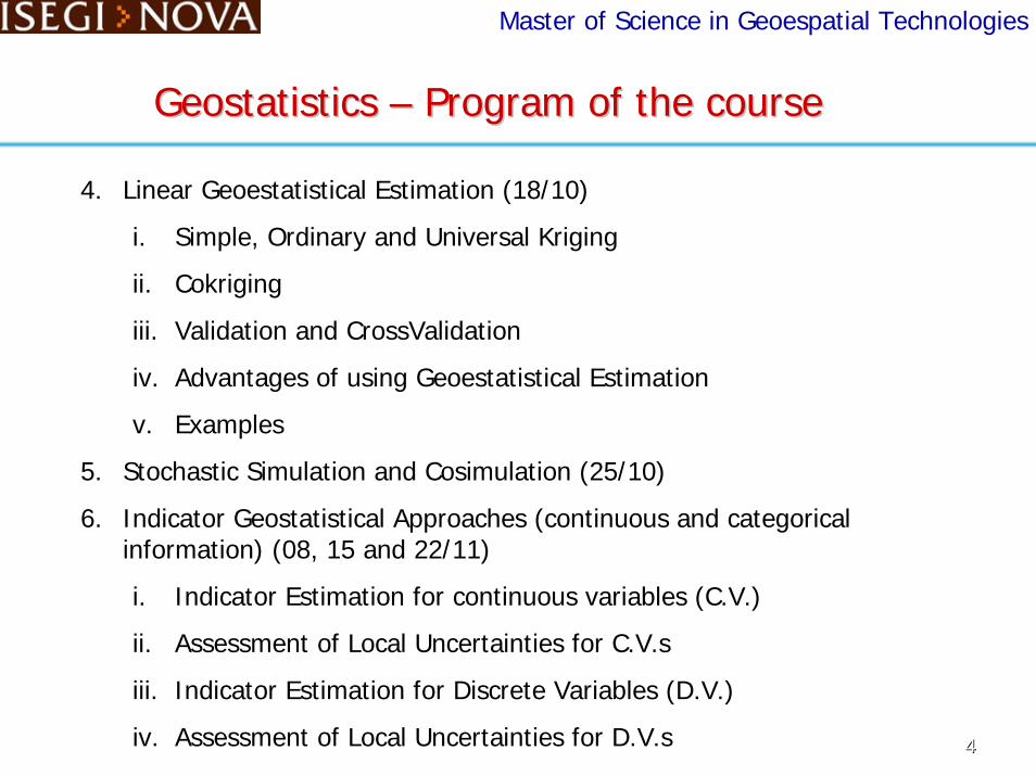
v. Indicator Simulation for CVs and DVs
vi. Assessment of Global Uncertainty
vii. Account for Secondary information
viii. Examples
7. Advantages of using Indicator Approaches (29/11)
8. Advanced Topics (06/12)
1. Decision Making in the face of Uncertainty
2. Propagation of uncertainties in spatial modeling
3. Spatial/Temporal Geostatistics
9. Final Remarks, Final Test and Presentations (13/12)
55

Master of Science in Geoespatial Technologies
Geostatistics Geostatistics –– ReferencesReferences
66
Basic Bibliography
Burrough, P. A., 1986. Principles of Geographical Information Systems for Land Resources Assessment. Clarendon Press – Oxford – London.
Burrough, P. A.; McDonnell, R. A.,1998. Principles of Geographical Information Systems. Oxford University Press, Inc, New York, USA.
Cressie, N., 1991. Statistics for Spatial Data. John Wiley and Sons, New York, USA.
Deutsch, C. V.; Journel, A. G., 1998. Geostatistical Software Library and User’s Guide. Oxford University Press, New York, USA.
Felgueiras, C. A., 1999 Modelagem ambiental com tratamento de incertezas em sistemas de informação geográfica: o paradigma geoestatístico por indicação. 165p. PhD Dissertation in Applied Computer – Instituto Nacional de Pesquisas Espaciais, São José dos Campos, Available athttp://www.dpi.inpe.br/teses/felgueiras , Dec,1999.
Goovaerts, P., 1997. Geostatistics for Natural Resources Evaluation. Oxford University Press, Inc, New York, USA.
Master of Science in Geoespatial Technologies
Geostatistics Geostatistics –– ReferencesReferences
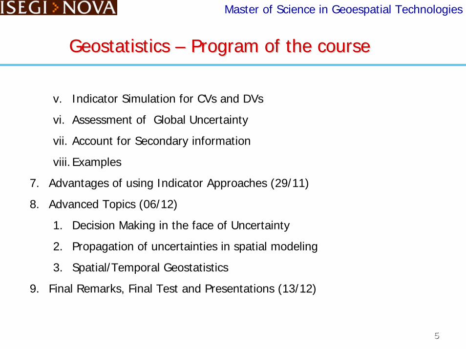
Basic Bibliography
Heuvelink, G. B. M., 1998. Error Propagation in Environmental Modelling with GIS. Taylor and Francis Inc, Bristol, USA.
Isaaks, E. H.; Srivastava, R. M., 1989. An Introduction to Applied Geostatistics. Oxford University Press, Inc, New York, USA.
Internet: http://www.ncgia.ucsb.edu/giscc/units/u128/u128_f.html,
http://en.wikipedia.org/wiki/Geostatistics ……..
Soares, A. 2000. Geoestatística para as Ciências da Terra e do Ambiente. Instituto Superior de Tecnico, IST Press. Lisboa, Portugal.
SPRING – Sistema de Processamento de Informações Geográficas –www.dpi.inpe.br/spring . Divisão de Processamento de Imagens –INPE-Brasil.
77

Master of Science in Geoespatial Technologies
Geostatistics Geostatistics –– Dinamic of the courseDinamic of the course
• Theoretical Classes with examples, mainly in SPRING
• Labs
• 2 Tests
• Student Presentations
• What software will be used? Free Choice
• ArcView, ArcGIS module, GSLIB, R, SAS, SPRING, VarioWin, …..
88

Master of Science in Geoespatial Technologies
What is the Geostatistics? Some Definitions
Geostatistics is concerned with “the study of phenomena that
fluctuate in space” and/or time. Geostatistics offers a
collection of deterministic and statistical tools aimed at
understanding and modeling spatial variability.
(Deutsch and Journel)
Geostatistics Geostatistics –– Initial ConceptsInitial Concepts
99

Master of Science in Geoespatial Technologies
What is Geostatistics? Some Definitions
Geostatistical offers a way of describing the spatial continuity that is an essential feature of
many natural phenomena and provides adaptations of classical regression techniques
to take the advantage of this continuity. (Isaaks and Srivastava)
Geostatistics provides a set of statistical tools for incorporating the spatial and temporal
coordinates of observations in data processing. (Goovaerts)
Geostatistics Geostatistics –– Initial ConceptsInitial Concepts
1010

Master of Science in Geoespatial Technologies
Geostatistics – Application Fields
Mining, petroleum, geophysics, geochemistrysoil science, forestry, agriculture (esp. in precision farm), environmental control,
landscape ecology, remote sensing,hydrology, oceanography, meteorology, ....
Geostatistics = Theory of regionalized variables
Statistical tools for analyzing space/time information
Geostatistics Geostatistics –– Initial ConceptsInitial Concepts
1111

Master of Science in Geoespatial Technologies
What is Geostatistics?
Geostatistics Geostatistics –– Initial ConceptsInitial Concepts
http://en.wikipedia.org/wiki/Geostatistics
Geostatistics explains not only its applications within Geographic Information Systems but also the numerous applications of mathematical analysis on varied spatial datasets, the most prominent being a digital elevation model, from which any number of analyses may be derived.
Geostatistics is also applied in varied branches of human geography, particularly those involving the spread of disease (epidemiology), the practice of commerce and military planning (logistics), and the development of efficient spatial networks.
1212

1313
Master of Science in Geoespatial Technologies
SamplingSpatial sampling involves determining a limited number of locations in a geo-space for faithfully measuring phenome-na that are subject to dependency and heterogeneity.
Dependency suggests that since one location can predict the value of another location, we do not need observations in both places. Heterogeneity suggests that this relation can change across space, and therefore we cannot trust an observed degree of dependency beyond a region that may be small. Basic spatial sampling schemes include random, clustered and systematic. (http://en.wikipedia.org/wiki/Spatial_analysis
Each sample point α is represented by its (x,y,z) coord.
(x,y) is the 2-d space location
z is the attribute value
Geostatistics Geostatistics –– Initial ConceptsInitial Concepts

1414
Master of Science in Geoespatial Technologies
• Earth sciences data are typically distributed in space and/or time. Knowledge of an attribute value is of interest only if location and/or time of measurement are known and accounted for in the data analysis. (Goovaerts)
• Continuous x Categorical Variables (Attribute representations)
Continuous variables: may take on any value within a finite or infinite interval.Examples: elevation, temperature, mineral grade, pollutant concentration, weight, ...)
Categorical variables examples: may take discrete values or categories. Examples: type of vegetation, class of soil, number of population, ….)
Geostatistics Geostatistics –– Initial ConceptsInitial Concepts

1515
Master of Science in Geoespatial Technologies
Input: A Set of Points sampled sparsely distributed in a spatial regionEach point represents a measurement of a variable (spatial attribute) that occurs in that spatial location.
Output: A SPATIAL DATA MODEL (computer/mathematical representation) that allows one to perform estimations and/or simulations for attribute values at spatial/temporal locations not sampled.
DETERMINISTIC X STOCHASTIC MODELS
Geostatistics Geostatistics –– Initial ConceptsInitial Concepts

1616
Master of Science in Geoespatial Technologies
QUESTIONS ???????
How many samples we need as input?How they must be distributed in space?
Are the Samples a good representation of the attribute variation in my region of interest?
What are the problems with undersampling, oversampling and clusters?
Can my Sample Set lead to a good spatial model, with the geostatistical tools?
What is a good Data Model? How to measure the quality of the output Data Model?
Geostatistics Geostatistics –– Initial ConceptsInitial Concepts
1717
Master of Science in Geoespatial Technologies
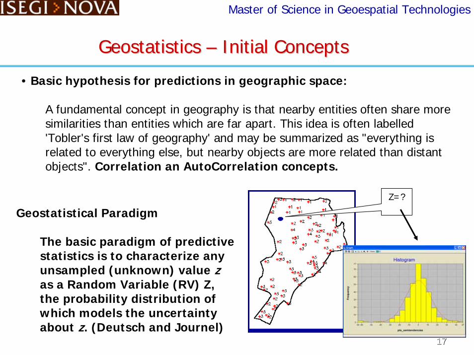
• Basic hypothesis for predictions in geographic space:
A fundamental concept in geography is that nearby entities often share more similarities than entities which are far apart. This idea is often labelled 'Tobler's first law of geography' and may be summarized as "everything is related to everything else, but nearby objects are more related than distant objects". Correlation an AutoCorrelation concepts.
Z=?
Geostatistics Geostatistics –– Initial ConceptsInitial Concepts
Geostatistical Paradigm
The basic paradigm of predictive statistics is to characterize any unsampled (unknown) value zas a Random Variable (RV) Z, the probability distribution of which models the uncertainty about z. (Deutsch and Journel)

Master of Science in Geoespatial Technologies
Why using geostatistical procedures ? Data Modeling
Deterministic ProceduresDeterministic Procedures GeostatisticsGeostatistics
Geostatistics Geostatistics –– Initial Concepts and MotivationInitial Concepts and Motivation
Study AreaStudy Area
Inverse Distance Weighted
KrigingSimple MeanNearest NeighboursSample Set
1818
Master of Science in Geoespatial Technologies
Why using geostatistical procedures ? Data Modeling
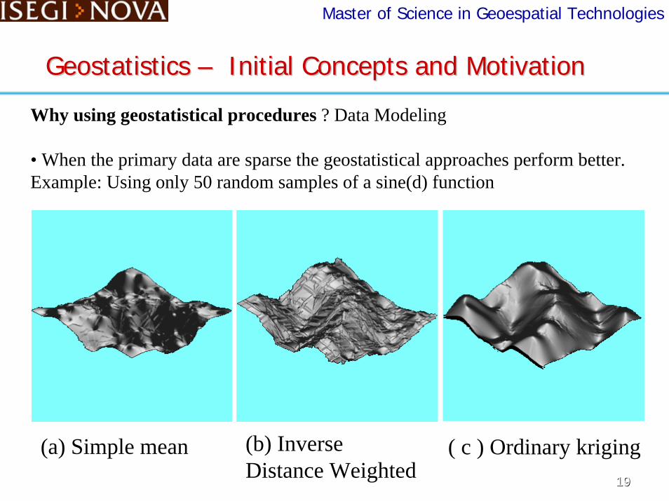
• When the primary data are sparse the geostatistical approaches perform better. Example: Using only 50 random samples of a sine(d) function
Geostatistics Geostatistics –– Initial Concepts and MotivationInitial Concepts and Motivation
(b) Inverse Distance Weighted
(a) Simple mean ( c ) Ordinary kriging1919

Master of Science in Geoespatial Technologies
Why using geostatistical procedures ? Data Modeling + Uncertainties• Geostatistical Indicator approaches allow estimation of continuous variables along with related uncertainties. Examples:
2.97
23.0
2.5
51.3
687.3
909.9
Geostatistics Geostatistics –– Initial Concepts and MotivationInitial Concepts and Motivation
Important : The uncertainty maps can be used to qualify the estimations 2020

2121
Master of Science in Geoespatial Technologies
Why using geostatistical procedures ? Categorical Data Modeling + Uncertainty• Geostatistical Indicator approaches allow estimation of categorical variables along with related uncertainties. Example:
Important : The uncertainty maps can be used to qualify the estimations
0.0
0.71
0.0
1.38
ArenosoMédio ArgilosoArgilosoMuito Argiloso
Geostatistics Geostatistics –– Initial Concepts and MotivationInitial Concepts and Motivation
Master of Science in Geoespatial Technologies
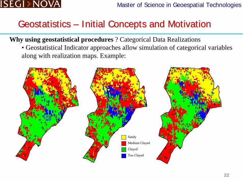
Why using geostatistical procedures ? Categorical Data Realizations• Geostatistical Indicator approaches allow simulation of categorical variables along with realization maps. Example:
Geostatistics Geostatistics –– Initial Concepts and MotivationInitial Concepts and Motivation
Sandy
Medium Clayed
Clayed
Too Clayed
2222

Master of Science in Geoespatial Technologies
Why using geostatistical procedures ? Categorical Data Realizations• Geostatistical Indicator approaches allow simulation of continous and categorical variables along with related uncertainties. Example:
SandyMedium ClayedClayedToo Clayed
0.0
0.71
0.0
1.37
Geostatistics Geostatistics –– Initial Concepts and MotivationInitial Concepts and Motivation
2323

2424
Master of Science in Geoespatial Technologies
Why using geostatistical procedures ? Account for secondary information• Geostatistical Indicator approaches allow the incorporation of secondary information as a soft variable to enhance the accuracy of inferences of the hard data. Example:
LEGEND
0.0
.66
SandyMed. Clayed ClayedToo Clayed
Geostatistics Geostatistics –– Initial Concepts and MotivationInitial Concepts and Motivation

Master of Science in Geoespatial Technologies
Why using geostatistical procedures ?. Decision Making in the face of Uncertainty, using the local uncertainty to constrain the classification.Example:
Geostatistics Geostatistics –– Initial Concepts and MotivationInitial Concepts and Motivation
Sandy
Medium Clay
Clay
Clayey
No class
Sandy
Medium Clay
Clay
Clayey
No class
2525

Master of Science in Geoespatial Technologies
Geostatistics Geostatistics –– Initial Concepts and MotivationInitial Concepts and Motivation
Summary
The Geostatistical Process1. Exploratory Data Analysis (Knowledge and Edition of the INPUT data)
2. Structural Analysis -Spatial Continuity Modeling (Autocorrelation Models)
3. Predictions ( Local and Global Estimations/Realizations of Continuous and Categorical attributes at unvisited locations)
4. Assessment of Uncertainties ( Local and Spatial Uncertainty about unsampled values )
Results are used in Spatial Modeling in a GIS Environment
2626

Master of Science in Geoespatial Technologies
2727
Geostatistics Geostatistics –– Initial Concepts and MotivationInitial Concepts and Motivation
Region of Study Interpolationkriging
StructuralAnalysis
• Derived Scenarios
• Uncertainty Maps
Conditional Simulation
Realizations Fields
Estimated Surfaceof the phenomenon
of interest
ExploratoryAnalysis
The Geostatistical Process

2828
Geostatistics Geostatistics –– MotivationMotivation
Master of Science in Geoespatial Technologies
Z1
Z2
Z3
Y
Unc(Z1)
Unc(Z2)
Unc(Z3)
Unc(Y)
Spatial Model: Y(u) = g(Z1(u),...,Zn(u)) for n inputs
The Uncertainties of the Input representations propagate to the
the Uncertainty of the Output representation.
• Spatial Analysis in GIS

Master of Science in Geoespatial Technologies
Geostatistics Geostatistics –– Initial Concepts and MotivationInitial Concepts and Motivation
END of Presentation
2929

Master of Science in Geoespatial Technologies
Geostatistics Geostatistics –– An Introduction to SPRINGAn Introduction to SPRING
Software Installation
Presentation
Data Modeling in SPRING
Data Importation
Visualization of Data
Handling Visualization
3030