Embed Size (px)
Citation preview

FINAL
Range Environmental Vulnerability Assessment
5-Year Review
Marine Corps Logistics Base Barstow
May 2013
Marine Corps Installations Command
06285037.0000
FINAL
Ran
ge
En
viro
nm
en
tal V
uln
era
bility
Asses
sm
en
t
5-Y
ear R
evie
w
Marin
e C
orp
s L
og
istic
s B
ase B
ars
tow
May 2
013
Marine Corps Installations Command MCI COM (GF-5) 3000 Marine Corps Pentagon, Room 2D153 Washington, DC 20350
FINAL
Range Environmental
Vulnerability Assessment
5-Year Review
Marine Corps Logistics Base Barstow
Barstow, California
May 2013
DISTRIBUTION STATEMENT B. Distribution authorized to U.S. Government agencies only
(Administrative or Operational Use) (October 2012). Other requests for this document shall be
referred to Marine Corps Installations Command.
06285037.0000
Report Prepared By:
701 Town Center Drive
Suite 600
Newport News, VA 23606


Marine Corps Installations Command Range Environmental Vulnerability Assessment 5-Year Report MCLB Barstow
i
Table of Contents
Executive Summary ES-1
1. Introduction 1-1
1.1. Purpose ......................................................................................................................... 1-1
1.2. The Scope and Applicability .......................................................................................... 1-2
1.3. REVA Assessment of Lead ........................................................................................... 1-7
1.4. Data Collection Effort .................................................................................................... 1-8
1.5. Report Organization ...................................................................................................... 1-8
2. Baseline Results and Installation Changes 2-1
2.1. Baseline Results ........................................................................................................... 2-1
2.2. Installation Changes ..................................................................................................... 2-2
3. Munitions Constituents Loading Rates and Assumptions 3-1
3.1. Munitions Constituents Loading Process ...................................................................... 3-1
3.1. Expenditure Data for MCLB Barstow ............................................................................ 3-2
3.2. REVA Munitions Constituents Loading Rate Calculator ............................................... 3-5
3.3. Small Arms Ranges ...................................................................................................... 3-5
3.3.1. Rifle Range .................................................................................................... 3-6
3.3.2. Pistol Range .................................................................................................. 3-7
3.3.3. Shotgun Range ............................................................................................. 3-7
4. Conceptual Site Model 4-1
4.1. Installation Profile .......................................................................................................... 4-1
4.2. Operational Range Profile ............................................................................................. 4-5
4.3. Physical Profile ............................................................................................................. 4-8
4.4. Surface Water Profile .................................................................................................. 4-12
4.5. Groundwater Profile .................................................................................................... 4-17

Table of Contents
ii
Marine Corps Installations Command Range Environmental Vulnerability Assessment 5-Year Report MCLB Barstow
4.6. Human Land Use and Exposure Profile ..................................................................... 4-21
4.7. Natural Resources Profile ........................................................................................... 4-23
4.8. Potential Pathways and Receptors ............................................................................. 4-24
4.8.1. Surface Water and Sediment Pathway ....................................................... 4-25
4.8.2. Groundwater Pathway ................................................................................. 4-26
5. Small Arms Range Assessments 5-1
5.1. Summary of the Small Arms Range Assessment Protocol .......................................... 5-1
5.2. Small Arms Ranges ...................................................................................................... 5-2
5.2.1. Rifle Range .................................................................................................... 5-8
5.2.2. Pistol Range .................................................................................................. 5-8
5.2.3. Shotgun Range ............................................................................................. 5-9
5.2.4. SARAP Assessment Results ...................................................................... 5-10
6. References 6-1
List of Tables
Table ES0-1: Summary of Baseline Assessment Results for MCLB Barstow ................................ 2
Table ES0-2: Summary of Five-Year Review Assessment Results for MCLB Barstow ................. 5
Table 2-1: Summary of SARs Evaluated in the Baseline Assessment ....................................... 2-1
Table 2-2: Lead Loading from 1955 to 2012 at the SARs ............................................................ 2-2
Table 3-1: SARS at MCLB Barstow ............................................................................................. 3-6
Table 5-1: SAR Qualitative Ranking ............................................................................................ 5-2
List of Figures
Figure 1-1: Site Location Map ..................................................................................................... 1-3
Figure 1-2: Installation Map ......................................................................................................... 1-4
Figure 3-1: Operational Ranges .................................................................................................. 3-3

Table of Contents
Marine Corps Installations Command Range Environmental Vulnerability Assessment 5-Year Report MCLB Barstow
iii
Figure 4-1: Graphical Conceptual Site Model ............................................................................. 4-3
Figure 4-2: Surface Water Features .......................................................................................... 4-13
Figure 5-1: Rifle Range ............................................................................................................... 5-3
Figure 5-2: Pistol and Shotgun Ranges ...................................................................................... 5-5
Appendices
A. Small Arms Range Assessment Protocol Tables
B. Photographic Log

Acronym List
iv
Marine Corps Installations Command Range Environmental Vulnerability Assessment 5-Year Report MCLB Barstow
Acronym List
Acronym Definition
amsl Above Mean Sea Level
bgs Below Ground Surface
BLM Bureau of Land Management
CA California
cal caliber
CSM Conceptual Site Model
DoD Department of Defense
DoDI Department of Defense Instruction
DoDIC Department of Defense Identification Code
DWMA Desert Wildlife Management Area
ft/d Feet per day
FY Fiscal Year
GIS Geographic Information System
HMX Cyclotetramethylene Tetranitramine
INRMP Integrated Natural Resources Management Plan
lb/yr pound per year
Marine Corps United States Marine Corps
MC Munitions Constituents
MCI COM Marine Corps Installations Command
MCLB Marine Corps Logistics Base
mg/kg Milligram per Kilogram

Acronym List
Marine Corps Installations Command Range Environmental Vulnerability Assessment 5-Year Report MCLB Barstow
v
Acronym Definition
MIDAS Munitions Items Disposition Action System
MMRP Military Munitions Response Program
MOA Memorandum of Agreement
mph Miles per hour
PRA Preliminary Range Assessment
RDX Cyclotrimethylene Trinitramine
REVA Range Environmental Vulnerability Assessment
RFMSS Range Facility Management Support System
SAR Small Arms Range
SARAP Small Arms Range Assessment Protocol
SDZ Surface Danger Zone
T/E Threatened and Endangered
TECOM Training and Education Command
TNT Trinitrotoluene
U.S. United States
USGS United States Geological Survey

Acronym List
vi
Marine Corps Installations Command Range Environmental Vulnerability Assessment 5-Year Report MCLB Barstow
This page intentionally blank

Marine Corps Installations Command Range Environmental Vulnerability Assessment 5-Year Report MCLB Barstow
ES-1
Executive Summary
The United States (U.S.) Marine Corps (Marine Corps) Range Environmental Vulnerability Assessment (REVA) program meets the requirements of the Department of Defense (DoD) Directive 4715.11 Environmental and Explosives Safety Management on Operational Ranges within the United States and DoD Instruction 4715.14 Operational Range Assessments.
The REVA program is a proactive and comprehensive program designed to support the Marine Corps’ Range Sustainment Program. Operational ranges across the Marine Corps are being assessed through the REVA program to identify areas and activities that are subject to possible impacts from external influences, as well as to determine whether a release or substantial threat of a release of munitions constituents (MC) from operational ranges to off-range areas creates an unacceptable risk to human health and/or the environment. This is accomplished through a baseline assessment of operational range areas, periodic five-year review assessments, and, where applicable, the use of fate and transport modeling of the REVA indicator MC based upon site-specific environmental conditions at the operational ranges and training areas.
This report presents the five-year review assessment results for the operational ranges at Marine Corps Logistics Base (MCLB) Barstow, California (CA). This report serves as the first five-year review assessment and documents the period of munitions loading from 2007 through 2012. The baseline assessment completed in 2008 documented all munitions use through 2006.
Military Munitions Training and Operations
MCLB Barstow is located in San Bernardino County in south-central California, approximately 3.5 miles east of the city of Barstow, CA. The installation was transferred to the Marine Corps from the U.S. Navy on December 28, 1942, and consisted of the Nebo Area, which at that time was called the Marine Corps Depot of Supplies. The Commanding General of the Marine Corps Depot of Supplies transferred operations from San Francisco to Barstow in 1955 to establish several small arms ranges (SARs) for Marine marksmanship training. The base was designated as MCLB Barstow in November 1978.
The installation comprises approximately 5,405 acres, and it is still divided into the three original areas: the Nebo Area (1,286 acres), the Yermo Annex (1,681 acres), and the Rifle Range Complex (2,438 acres). The dry bed of the Mojave River forms the northern boundary of the Nebo Area. The Yermo Annex is four miles east of the Nebo Area, north of the Mojave River bed, and between Interstates 15 and 40. The Rifle Range Complex is located south of Interstate 40 and directly south of the Nebo Area.

Executive Summary
ES-2
Marine Corps Installations Command Range Environmental Vulnerability Assessment 5-Year Report MCLB Barstow
The primary mission of MCLB Barstow is to procure, maintain, store, and issue supplies and equipment for Marine Corps facilities worldwide, as well as to repair and rebuild DoD equipment. The Nebo Area contains base headquarters and administration, storage, recreational activities, shopping, and housing functions. The Yermo Annex is used for storage and industrial activities. The Rifle Range Complex contains three SARs and is the only area on the installation where military training occurs.
REVA assesses all operational ranges and training areas at the Marine Corps installation, including those where training activities use high explosives ammunition. However, only small arms training activities are conducted at MCLB Barstow; therefore, estimation of deposition and modeling of the fate and transport of other MC (trinitrotoluene (TNT), cyclotetramethylene tetranitramine (HMX), cyclotrimethylene trinitramine (RDX), and perchlorate) were not considered in this evaluation. Should information in the future indicate the use of high explosive ammunition, the REVA assessment will evaluate the data available.
The primary MC at SARs is lead because it is the most prevalent (by weight) potentially hazardous constituent associated with small arms ammunition. SARs are qualitatively assessed under the REVA program to identify factors that influence the potential for lead migration. The tool used to evaluate SARs is called the Small Arms Range Assessment Protocol (SARAP). The SARAP incorporates information such as lead loading, surface water and groundwater characteristics, and potential receptors to determine if there is a possible threat of a release of lead from the sites.
The baseline REVA assessment, completed in May 2008, evaluated the three SARs within the Rifle Range Complex: the Rifle Range, the Pistol Range, and the Shotgun Range. Prior to assessing the current data for this five-year review, the results of the baseline assessment were considered. Table ES-1 provides a summary of the results of the baseline assessment.
Table ES0-1: Summary of Baseline Assessment Results for MCLB Barstow
SAR Surface Water Ranking Groundwater Ranking Assessing in 5‐Year Review
Rifle Range Minimal Minimal Yes
Pistol Range Minimal Minimal Yes
Shotgun Rangea Minimal Minimal Yes
a. The Shotgun Range was referred to as the Close Combat Pistol Range in the baseline report. Shotgun Range is be used in the five‐year review for consistency with the current installation naming convention.
The SARs received minimal rankings for surface water and groundwater in the baseline assessment. These minimal rankings indicate little potential for off-range migration of lead to human or ecological receptors. Based on these rankings, it was determined no further action was

Executive Summary
Marine Corps Installations Command Range Environmental Vulnerability Assessment 5-Year Report MCLB Barstow
ES-3
required for these SARs. The five-year review effort reevaluates the ranges to ensure any changes that might affect lead transport from the SARs are captured.
Five-Year Review Pathway and Receptor Analysis for MCLB Barstow
The following exposure pathways were evaluated to determine the potential for lead to migrate off of the operational range area.
Surface water runoff, including sediment transport
Leaching to groundwater and subsequent groundwater flow
Potential exposure points for receptors used in the evaluation include the following:
The water supply wells located within the boundaries of MCLB Barstow in Yermo Annex
Potential off-installation wells located down gradient of the Yermo Annex
Surface water bodies, including ephemeral streams and wetlands, that are used for groundwater recharge and potentially support special status species
Several physical parameters were used to evaluate the SARs. The relevant information is provided here to summarize the full suite of information provided in the REVA 5-Year Review Report.
MCLB Barstow is located in the Mojave Desert within the Mojave River valley. The climate is characterized by low precipitation (averaging 4.4 inches per year), high temperatures, and low humidity. Localized flooding may occur with high intensity summer storms.
Surface Water and Sediment Pathway
The primary pathway assessed was the transport of lead via surface water runoff from MCLB Barstow operational ranges to off-range areas. Surface runoff follows natural topographic gradients from the ranges through incised ephemeral washes northward toward the Mojave River, approximately 0.8 miles from the ranges. Such drainage patterns can transport lead downstream through dissolution in runoff water or erosion of soil with lead (particularly on the berms). However, because site soils and storm water measurements indicate neutral or slightly alkaline conditions (soil pH between 7.4 and 8.4; an average storm water pH of 8.1), lead migration via dissolution in surface water is likely to be limited. The soil erosion potential at the Rifle Range Complex can be significant because of the sparse vegetation cover, moderately steep topography, and the occurrence of flash floods capable of moving large loads of sediment during high-intensity rainfall. Therefore, soil erosion is a potential pathway for MC mobilization into surface water runoff and, ultimately, into streams. Wind erosion also can be significant at MCLB

Executive Summary
ES-4
Marine Corps Installations Command Range Environmental Vulnerability Assessment 5-Year Report MCLB Barstow
Barstow. Although wind might not be a significant mechanism for lead transport off range, it can increase erosion of the bullet pockets and surrounding soils that help keep the lead in place.
Engineering controls that limit run-on from entering the Shotgun and Pistol Ranges combined with periodic maintenance conducted as needed at all three ranges (addition of soil to bullet pockets) minimize the potential for erosion and surface water transport of lead.
Surface water is only present in the Mojave River and associated drainages after infrequent rain events. Therefore there are no known uses of surface water (e.g., potable water source, irrigation, recreation) by human receptors. Exposure to ecological receptors (the desert tortoise) via surface water is limited because the water either evaporates or infiltrates into surficial soils quickly.
Groundwater Pathway
The groundwater pathway was evaluated because of the highly permeable gravelly sandy soil present at the Rifle Range Complex. High temperatures and low humidity in the region contribute to high rates of evaporation. Additionally the depth to groundwater is great. Based on these factors, the potential for infiltration to groundwater is very limited.
Site conditions suggest the pH of the soil is neutral or slightly alkaline, indicating that the lead deposited on site likely will remain absorbed to the soil instead of migrating down with the limited infiltration that occurs. Furthermore, the depth to groundwater at the ranges limits the potential for lead to migrate downward to the groundwater. Studies have indicated that the depth to groundwater approximately 1.5 miles northwest of the Rifle Range ranges from 160 to 210 feet below ground surface (bgs). Groundwater depth on the alluvial fan south of Interstate 40 near the Rifle Range Complex has been documented to be 175 feet bgs (Jacobs Engineering, 1997; Tetra Tech, 2003).
The closest groundwater extraction wells for potable use are located at the Yermo Annex, northeast of the Rifle Ranges. It is unlikely for lead in groundwater at the Rifle Ranges to be transported to these wells due to the water chemistry, the significant distance to the wells, and the presence of the Harper Lake-Camp fault that traverses the Rifle Range complex. It could be possible for lead transported in the ephemeral washes and the Mojave River to recharge the Mojave River aquifer within the Yermo Annex where the supply wells are screened. However, this pathway likely is limited due to storm water pH of 8 that favors a condition for lead to precipitate out of solution or remain bound to soil instead of dissolving in water. The pathway is further limited by the control side berm structures, which reduce the surface water runoff rate at the Rifle Ranges and the travel distance that will lead to dilution.
Results and Conclusions of the REVA Five-Year Review

Executive Summary
Marine Corps Installations Command Range Environmental Vulnerability Assessment 5-Year Report MCLB Barstow
ES-5
A summary of the results and conclusions for the SARs assessed at MCLB Barstow in the REVA five-year review are presented in Table ES-2.
Table ES0-2: Summary of Five-Year Review Assessment Results for MCLB Barstow
SAR Surface Water Ranking Groundwater Ranking
Rifle Range Minimal Minimal
Pistol Range Minimal Minimal
Shotgun Range Minimal Minimal
The minimal rankings for surface water and groundwater indicate a low potential for migration of lead to receptor points. The rankings are based on the low use of the ranges and site characteristics, such as very low precipitation, high evaporation rates, neutral pH of surface water and soils, and the deep groundwater table. These elements indicate the limited potential for lead to migrate via surface water, sediment, or groundwater transport. No further action is recommended at this time. If conditions change at the ranges prior to the next five-year review, such as an increase in training, the ranges may be reevaluated to assess how the changes impact the potential migration of lead.

Executive Summary
ES-6
Marine Corps Installations Command Range Environmental Vulnerability Assessment 5-Year Report MCLB Barstow
This page intentionally blank

Marine Corps Installations Command Range Environmental Vulnerability Assessment 5-Year Report MCLB Barstow
1-1
1. Introduction
1.1. Purpose
The United States (U.S.) Marine Corps (Marine Corps) Range Environmental Vulnerability Assessment (REVA) program meets the requirements of the Department of Defense (DoD) Directive 4715.11 Environmental and Explosives Safety Management on Operational Ranges within the United States and DoD Instruction (DoDI) 4715.14 Operational Range Assessments.
The REVA program is a proactive and comprehensive program designed to support the Marine Corps’ Range Sustainment Program. Operational ranges across the Marine Corps are being assessed to identify areas and activities that are subject to possible impacts from external influences, as well as to determine whether a release or substantial threat of a release of munitions constituents (MC) from operational ranges to off-range areas creates an unacceptable risk to human health and/or the environment. This is accomplished through periodic five-year review assessments of operational range areas.
This report presents the five-year review results for the operational ranges and training areas at the Marine Corps Logistics Base (MCLB) Barstow, California (CA). This report serves as the first five-year review assessment documenting the period of munitions use from 2007 through 2012. The baseline assessment conducted in 2007 documented munitions use at MCLB Barstow from the initial use of the ranges in 1955 through 2006.
MCLB Barstow is located in San Bernardino County in south-central California, approximately 3.5 miles east of the city of Barstow, CA (Figure 1-1). Its primary mission is to procure, maintain, store, and issue supplies and equipment for Marine Corps facilities worldwide, as well as to repair and rebuild DoD equipment. MCLB Barstow comprises approximately 5,405 acres. The installation is divided into three areas: the Nebo Area (1,286 acres), the Yermo Annex (1,681 acres), and the Rifle Range Complex (2,438 acres) (Figure 1-2) (Tierra Data, 2011).
The Nebo Area contains base headquarters and administration, storage, recreational activities, shopping, and housing functions. The Yermo Annex is used for storage and industrial activities, and the Rifle Range Complex is where the three small arms ranges (SARs) are located. The dry bed of the Mojave River forms the northern boundary of the Nebo Area. The Yermo Annex is four miles east of the Nebo Area, north of the Mojave River bed, and between Interstates 15 and 40. The Rifle Range Complex is located south of Interstate 40 and directly south of the Nebo Area (Figure 1-2).

Section 1 Introduction
1-2
Marine Corps Installations Command Range Environmental Vulnerability Assessment 5-Year Report MCLB Barstow
1.2. The Scope and Applicability
The scope of the REVA program includes Marine Corps operational ranges located within the United States and overseas. Operational ranges (as defined in 10 United States Code 101(e)(3)) include, but are not limited to, fixed ranges, live-fire maneuver areas, SARs, buffer areas, and training areas where military munitions are known or suspected to have been used currently or historically. Operational ranges used exclusively for small arms training are evaluated qualitatively under REVA. Although the Marine Corps (specifically the Training and Education Command [TECOM]) purposely separates operational ranges and training areas, the term “operational range” includes both operational ranges and training areas in this document.
A number of range types are excluded specifically from DoDI 4715.14 and are not assessed as part of the REVA program. Operational ranges that have a Resource Conservation and Recovery Act Subpart X permit are excluded since they are monitored under a specific regulatory program. Military Munitions Response Program (MMRP) sites are excluded because they are nonoperational ranges and no longer are used for their intended purpose. Additionally, the management and funding of MMRP sites are conducted under a separate DoD program. Any ranges located wholly indoors also are not included, as any MC associated with these ranges are assumed to be contained and not available to the environment.
The MCLB Barstow operational ranges assessed in the baseline report and this five-year review are SARs. MC associated with small arms ammunition commonly used at operational ranges include lead, antimony, copper, and zinc. REVA focuses on lead as the MC indicator for SARs because lead is the most prevalent (by weight) potentially hazardous constituent associated with small arms ammunition. Lead is geochemically specific regarding its mobility in the environment. Site-specific conditions must be known (i.e., geochemical properties) in order to quantitatively assess lead migration. These site-specific geochemical properties are identified by sampling and analysis and cannot be observed physically. Without site-specific physical and chemical characterization, lead cannot be modeled effectively using fate and transport modeling. As such, the potential for lead migration is evaluated using a qualitative approach, as discussed in Section 1.3.
REVA assesses all operational ranges and training areas at the Marine Corps installation, including those where training activities use high explosives ammunition. However, only small arms training activities are conducted at MCLB Barstow; therefore, estimation of deposition and modeling of the fate and transport of other MC (TNT, HMX, RDX, and perchlorate) were not considered in this evaluation. Should information in the future indicate the use of high explosive ammunition the REVA assessment would evaluate the data available.

Afton Canyon
Mojave River
aMCLB Barstow
NOVEMBER 2012FIGURE 1-1Site Location Map
Range Environmental Vulnerability Assessment
5-Year ReviewMCLB Barstow
Barstow, CA
0 5 102.5
Miles
^MCLB Barstow
Date: November 2012Source: MCLB Barstow GIS Office 2012
±Legend
Installation Boundary
Section 1 Introduction
1-4
Marine Corps Installations Command Range Environmental Vulnerability Assessment 5-Year Report MCLB Barstow
This page intentionally blank

Date: November 2012Source: MCLB Barstow GIS Office 2012 Aerial - ESRI/Bing Maps
0 4,000 8,0002,000
Feet
LegendInstallation BoundaryHarper Lake - Camp Rock Fault System
Surface Water CourseDryIntermittent
Rifle Range Complex
MCLB Barstow
Mojave River
FIGURE 1-2Installation MapRange Environmental
Vulnerability Assessment5-Year ReviewMCLB Barstow
Barstow, CA
Elephant Mountain
Yermo Annex
Nebo Area
Small Arms Ranges (3)
§̈¦15
§̈¦40
±
^MCLB Barstow

Section 1 Introduction
1-6
Marine Corps Installations Command Range Environmental Vulnerability Assessment 5-Year Report MCLB Barstow
This page intentionally blank

Section 1
Introduction
Marine Corps Installations Command Range Environmental Vulnerability Assessment 5-Year Report MCLB Barstow
1-7
1.3. REVA Assessment of Lead
Metallic lead (such as recently fired, unweathered bullets and shot) generally has low chemical reactivity and low solubility in water and is relatively inactive in the environment under most ambient or everyday conditions. However, a portion of lead deposited on a range may become environmentally active if the right combination of conditions exists.
Site-specific environmental conditions and MC (lead) loading totals are used in the qualitative evaluation of SARs to assess whether the potential exists for a release or substantial threat of a release of MC from an operational range or range complex area to an off-range area. The evaluation, referred to as the Small Arms Range Assessment Protocol (SARAP), is conducted for each SAR at the installation. The amount of lead deposited on the range is estimated using expenditure reporting or other documentation provided by the installation.
Other considerations for the qualitative evaluation for SARs include the range design and layout, the physical and environmental conditions of the area (as documented through the conceptual site model [CSM]), current and past operation and maintenance practices, and potential receptor groups. Receptor groups considered in the REVA process include human and ecological receptors (defined in the REVA analysis as any threatened or endangered [T/E] species or species of concern). Human exposure pathways considered include consumption of surface water and groundwater for off-range human receptors, as described in the REVA Five-Year Review Manual (HQMC, 2010). Exposure pathways for off-range ecological receptors include direct consumption of surface water and direct exposure to surface water and sediment. Other off-range exposure scenarios (e.g., soil ingestion, incidental dermal contact, bioaccumulation, food chain exposure) currently are not considered in the REVA process unless site-specific considerations warrant an evaluation.
Environmental sampling and analysis (i.e., field data collection) is conducted if the results of the SARAP evaluation suggest an off-range release of MC where receptors may be present. Field data collection activities are conducted to determine whether an off-range release has occurred and whether such a release constitutes an unacceptable risk to human health and the environment.
The process and assumptions used to estimate the amount of MC (lead) deposited onto the SARs, defined in REVA as MC loading, are discussed in Section 3. The SARAP qualitative assessment process and the results of the SAR assessments are presented in Section 5. A detailed description of the REVA MC Loading Rate Calculator tool used to estimate MC deposition on operational ranges is provided in the REVA Reference Manual (HQMC, 2009).
This five-year review REVA report presents the conditions of the operational ranges at the time the assessment was conducted. The assessment was performed using available data and

Section 1 Introduction
1-8
Marine Corps Installations Command Range Environmental Vulnerability Assessment 5-Year Report MCLB Barstow
personnel interviews and is supplemented with information from external sources, including reports and documentation.
1.4. Data Collection Effort
A thorough review of data collected during the baseline assessment was conducted prior to collecting data from the installation for the five-year review. Data required for the operational range assessments were obtained from the installation during a site visit by the REVA assessment team, from the Marine Corps Installation Command (MCI COM) GF, and from external data sources. Data collected include documents and reports prepared for the installation, such as expenditure data, range operating procedures, natural and cultural resource surveys, weather records, and geographic information systems (GIS) files.
The REVA team conducted a site visit to MCLB Barstow on 22 and 23 March 2012. MCI COM and TECOM personnel accompanied the team during the site visit. The installation site visit involved reviewing data repositories and conducting interviews with installation personnel from the following offices:
Environmental Division, including the Natural Resource/Cultural Resources Office
Base Operations
Facilities Management Division
GIS
Subject matter experts within each of these offices were interviewed to identify areas of interest and specific concerns pertaining to each office. Specific issues relating to operational range use and potential impacts to training were the focus of these discussions.
During the five-year review installation visit, the REVA team observed all of the operational ranges to survey the physical condition of each range and note firing points, impact areas, engineered controls, and other environmental factors (e.g., areas of erosion, potential migration routes).
1.5. Report Organization
This REVA five-year review environmental range assessment report for MCLB Barstow is organized into the following sections:
Section 1 – Introduction
Section 2 – Baseline Results and Installation Changes
Section 3 – Munitions Constituents Loading Rate and Assumptions
Section 4 – Conceptual Site Model

Section 1
Introduction
Marine Corps Installations Command Range Environmental Vulnerability Assessment 5-Year Report MCLB Barstow
1-9
Section 5 – Small Arms Range Assessments
Section 6 – References

Section 1 Introduction
1-10
Marine Corps Installations Command Range Environmental Vulnerability Assessment 5-Year Report MCLB Barstow
This page intentionally blank

Marine Corps Installations Command Range Environmental Vulnerability Assessment 5-Year Report MCLB Barstow
2-1
2. Baseline Results and Installation Changes
2.1. Baseline Results
The baseline assessment for MCLB Barstow was completed in May 2008 and evaluated all information from the range inception (1955) through 2006. Three operational SARs were identified in the baseline assessment; these same ranges remain operational and are the basis of this five-year review. The results of the baseline assessment are documented in the Range Environmental Vulnerability Assessment Marine Corps Logistics Base Barstow (Malcolm Pirnie, 2008). Table 2-1 lists the areas that were evaluated using the SARAP in the baseline assessment and a summary of the results.
Table 2-1: Summary of SARs Evaluated in the Baseline Assessment
SAR Surface Water Ranking Groundwater RankingAssessing in 5-Year Review
Rifle Range Minimal Minimal Yes
Pistol Range Minimal Minimal Yes
Shotgun Rangea Minimal Minimal Yes
a. The Shotgun Range was referred to as the Close Combat Pistol Range in the baseline report. Shotgun Range is used in the five‐year review for consistency with the current installation naming convention.
As the three SARs are adjacent to one another, the physical setting and environmental characteristics were the same for all three ranges in the baseline assessments. Characteristic differences between the ranges that factored into the assessments included operational attributes, such as ammunition used, expenditure rates, directions of fire, and engineered controls.
The minimal ratings assigned for surface water and groundwater pathways/receptor interactions were primarily a result of the limited range use, low precipitation, and neutral soil, storm water, and groundwater pH. These factors limit migration of lead off range. Additionally, human receptors were not identified near the ranges, and limited potential exists for ecological receptor exposure.

Section 2 Baseline Results and Installation Changes
2-2
Marine Corps Installations Command Range Environmental Vulnerability Assessment 5-Year Report MCLB Barstow
2.2. Installation Changes
Some changes have occurred at the MCLB Barstow range complex since the baseline assessment was completed in 2008. From October 2010 to March 2011, range improvements were completed on the SARs. The installation upgraded targets, cleaned target carriages, filled bullet pockets with sand, cleaned buildings at the ranges, and surveyed all firing points.
The training tempo on the ranges has increased since the baseline assessment. Nonmilitary use of the ranges had occurred on a regular but infrequent basis until 2006, when nonmilitary use ceased. From 2006 through 2010, only Marines and the Military Police force used the ranges. In May 2010, the Commanding Officer at MCLB Barstow made the ranges again available for nonmilitary use; the training frequency increased at that time.
The Shotgun Range was referred to as the Close Combat Pistol Range in the baseline assessment, as named in the Preliminary Range Assessment (PRA; USACE, 2001b). Base Operations personnel confirmed that this range always has been a shotgun range and use has not changed; therefore, it is referred to as the Shotgun Range in the five-year review in order to remain consistent with the current installation naming convention.
MCLB Barstow Base Operations now manages SAR expenditure data in the Range Facility Management Support System (RFMSS). RFMSS was not used prior to 2010, and very limited munitions use tracking data were available during the baseline assessment. The baseline assessment evaluated lead loading from 1955 through 1998 using data identified in the Preliminary Range Assessment for MCLB Barstow. Lead loading estimates between 1998 and 2007 were based on the amount of small arms ammunition allocated in one year and assumptions based on training iterations and range use provided by installation personnel. Additional details on the assumptions used to generate the lead loading estimates are provided in the MCLB Barstow REVA Report (Malcolm Pirnie, 2008).
Use of RFMSS was initiated in October 2010, and it provides actual expenditure data that can be used to more accurately estimate MC loading at the ranges. The values for the five-year review based on RFMSS data are slightly higher than those estimated for the 1998 to 2007 time period; however, the lead loading values are relatively low when compared to other ranges across the Marine Corps. Details on the lead loading process are described in Section 3. Table 2-2 shows the estimated lead loading for the three ranges for each time period.
Table 2-2: Lead Loading from 1955 to 2012 at the SARs
SAR 1955-1998 1998-2007 2008-2012
Rifle Range 1,425 130 279

Section 2
Baseline Results and Installation Changes
Marine Corps Installations Command Range Environmental Vulnerability Assessment 5-Year Report MCLB Barstow
2-3
Pistol Range 1,544 101 359
Shotgun Range 250 101 92
Notes: Values are shown in pounds per year (lb/yr)

Section 2 Baseline Results and Installation Changes
2-4
Marine Corps Installations Command Range Environmental Vulnerability Assessment 5-Year Report MCLB Barstow
This page intentionally blank

Marine Corps Installations Command Range Environmental Vulnerability Assessment 5-Year Report MCLB Barstow
3-1
3. Munitions Constituents Loading Rates and Assumptions
SARs are the only type of operational range present at the installation. This section describes the process used to estimate the amount of lead deposition in these areas.
The qualitative analysis conducted under REVA requires estimation of the amount of indicator MC deposited on operational ranges in order to determine if there is a release or substantial threat of a release of MC off range and to potential off-range receptors. The deposition of indicator MC that is estimated under the REVA program is referred to as MC loading.
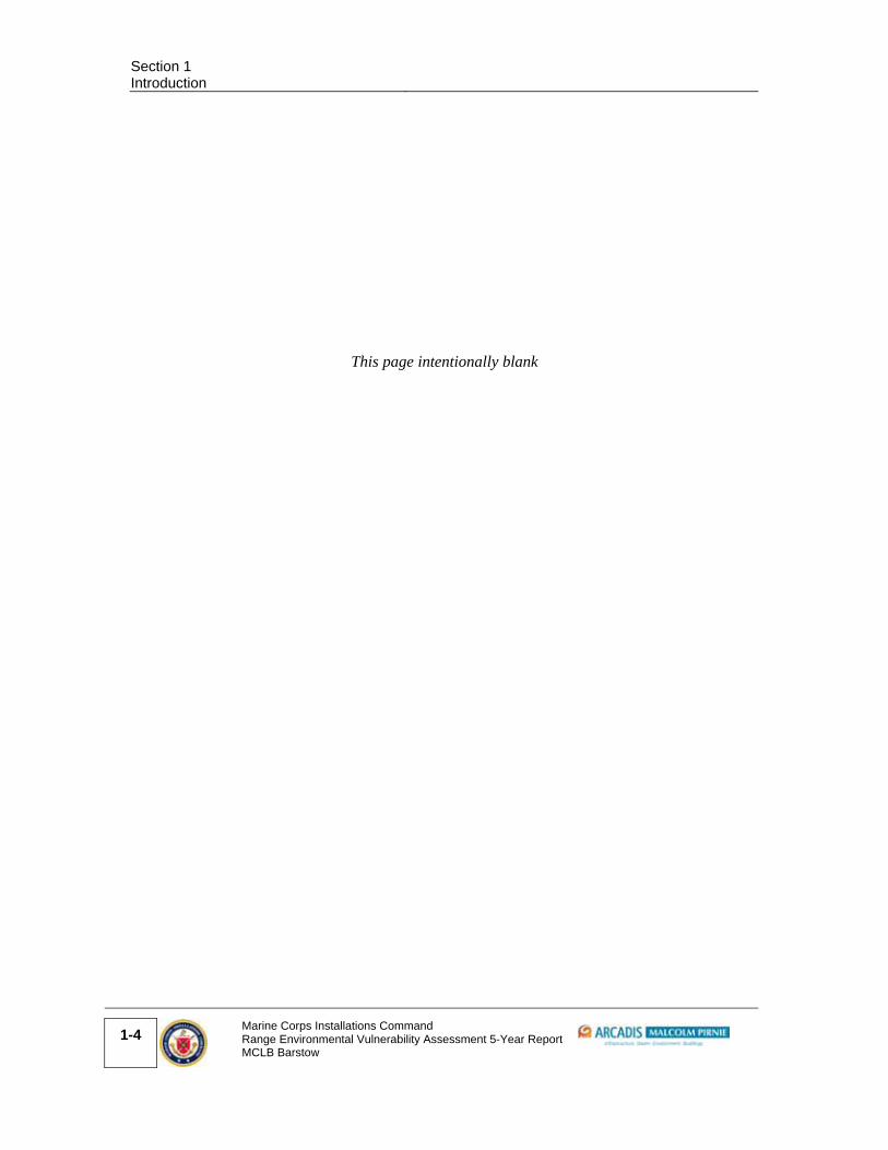
Operational range usage, boundaries, and other characteristics typically change over time. The objective of the five-year review is to determine the impact of MC loading since the baseline assessment. For this five-year review of training at MCLB Barstow, MC loading estimates include the period from 2007 to 2012. The general locations of SARs are depicted in Figure 3-1.
The MC loading process is outlined in the REVA Reference Manual (HQMC, 2009), while specifics pertaining to MCLB Barstow are discussed in its baseline REVA Report (Malcolm Pirnie, 2008). This five-year review utilizes and builds upon this process, developing MC loading estimates expressed as the average loading rate (pounds per year [lb/yr]) deposited annually in the defined area(s) of interest for the most recent time period (from baseline assessment to five-year review). Assumptions were made throughout this MC loading analysis process pertaining to the spatial distribution of the MC on the SARs, as summarized in Section 3.1 through Section 3.4. Section 3.5 provides a description of the SARs at MCLB Barstow.
3.1. Munitions Constituents Loading Process
The MC loading was estimated based on mass-loading principles. One key consideration for MC loading estimates is the MC content of each type or specific item(s) used at a given SAR. Information on the types and amounts of fillers associated with military munitions was developed primarily through the use of Internet-based sources, such as the Defense Ammunition Center’s Munitions Items Disposition Action System (MIDAS) Web site and the ORDATA database (2012), which is hosted on the Mine Action Information Center Web site of the James Madison University.Based on the known history and current training activities, the REVA team did not identify any MC loading areas at MCLB Barstow where high explosive– or perchlorate- containing munitions are used. All of the live-fire ranges at MCLB Barstow use small arms ammunition. The design and use of a SAR typically concentrates (via an impact berm) or limits

Section 3 Munitions Constituents Loading Rates and Assumptions
3-2
Marine Corps Installations Command Range Environmental Vulnerability Assessment 5-Year Report MCLB Barstow
affected areas to a relatively small, restricted area (typically the range fan), and the SARAP may be used to qualitatively assess it, as covered in Section 5. Lead loading was based on the total number of rounds used at the range, as reported in / estimated from the expenditure data, and the approximate lead content of each type of munition / DoD Identification Code (DoDIC). Details on this process are included in the MCLB Barstow baseline report and the REVA Reference Manual (Malcolm Pirnie, 2008; HQMC, 2009).
Deposition rates can provide a measure of potential impact from lead on training ranges; however, it is important to note that the lead loading rates differ from other MC loading rates. Given the nature of metals, lead deposition estimates assume no consumption from impact (i.e., no loss due to detonation of the munition) and that all of the lead contained within the munition is deposited on the range. However, the amount of lead that is deposited in a form that is exposed to the environment and available for transport (i.e., small particles and dust separated from the munition body upon impact) cannot be estimated without site-specific measurements. Fate and transport parameters for lead are dependent on site-specific geochemical properties, which may vary across small areas in a designated MC loading area and cannot be determined solely by physical observation. For these reasons, the lead loading estimates developed for this assessment are intended to serve as a general indicator of the total lead deposited rather than an estimate of the fraction of lead that is environmentally available for transport and exposure to receptors. Because of these limitations, SARs are qualitatively assessed using the SARAP. Results of the SARAP analysis are summarized in Section 6.
3.1. Expenditure Data for MCLB Barstow
MC loading for the five-year review at MCLB Barstow was estimated using RFMSS expenditure data obtained from Base Operations covering the period from October 2010 through March 2012. The use of documented expenditure data is preferred in the REVA program.
A quality review of the expenditure data provided by the installation resulted in a series of assumptions applicable across operational SARs at MCLB Barstow.
Expenditure data were not available for fiscal years (FYs) 2007–2010. It was assumed that the average yearly expenditure counts generated from the available data (October 2010 through March 2012) were suitable for extrapolation across the entire five-year review period. While Range Operations and Control indicated that the training tempo increased at the installation in May 2010, the extrapolation approach reflects higher range use and provides a conservative estimate of munition quantities used in training operations for the entire five-year review period. The REVA team used the available
Rifle Range Complex
Nebo Area Yermo Annex
Figure 3-1Operational Ranges
Date: November 2012Source: MCLB Barstow GIS Office 2012
Range EnvironmentalVulnerability Assessment
5-Year ReviewMCLB Barstow
Barstow, CA
Rifle Range
Pistol Range
Shotgun Range
0 1,500 3,000750
Feet
0 1.50.75
Miles
LegendORD - Rodman Desert Wildlife Management Area Installation Boundary
Surface Water CourseDryIntermittentHarper Lake - Camp Rock Fault System
±§̈¦40

Section 3 Munitions Constituents Loading Rates and Assumptions
3-4
Marine Corps Installations Command Range Environmental Vulnerability Assessment 5-Year Report MCLB Barstow
This page intentionally blank

Section 3
Munitions Constituents Loading Rates and Assumptions
Marine Corps Installations Command Range Environmental Vulnerability Assessment 5-Year Report MCLB Barstow
3-5
expenditure data to generate yearly expenditure averages, which then were applied to the MC loading calculations to generate conservative MC loading estimates.
According to Range Operations personnel, all rifle rounds are expended at the Rifle Range; all pistol rounds are expended at the Pistol Range; and all shotgun rounds are expended at the Shotgun Range. As such, the total rounds of each type were divided among the three SARs and totaled for the lead loading estimate.
FY 2012 data only account for 5.5 months of expenditures (10/1/2011–3/15/2012). Base operations confirmed training tempo was consistent throughout the year. Therefore, the REVA team assumed the 5.5 months of FY 2012 expenditure data are a representative sample of a full 12-month training total. As such, expenditure counts were increased proportionately to account for the entire 12-month period of FY 2012.
The expenditure summaries contained one DoDIC for which data regarding MC content were not available in MIDAS or other inventories. In this instance, a general description of the munitions associated with the DoDIC was identified as part of the installation data. This was reviewed along with available information regarding the associated range, its design, and its regulations. A surrogate MC loading factor was selected from a similar munition for use in the MC/lead loading calculations.
3.2. REVA Munitions Constituents Loading Rate Calculator
The REVA MC Loading Rate Calculator provides an automated method to calculate the overall loading of SARs in pounds per year. It uses information about the MC and information from the military munitions expenditure data obtained from the installation to provide lead loading estimates. As previously stated, expenditure data from RFMSS dating from October 2010 through March 2012 were used to estimate lead loading values for the five-year period between 2007 and 2012. The results of the lead loading for the three SARs are reported in Table 3-1. Lead loading estimates are quantified in pounds (lbs) of lead loaded to the SAR surface per year (yr) (lbs/yr). Further details regarding the REVA MC Loading Rate Calculator are provided in the REVA Reference Manual (HQMC, 2009).
3.3. Small Arms Ranges
The three SARs are located within MCLB Barstow’s Rifle Range Complex, which is immediately south of the Nebo Area and 3.5 miles southwest of the Yermo Annex. Military training on these ranges consists solely of small arms training for weapon proficiency and requalification. A summary of the SARs, including the average annual lead loading, is provided in Table 3-1, and general locations of the ranges is shown in Figure 3-1.

Section 3 Munitions Constituents Loading Rates and Assumptions
3-6
Marine Corps Installations Command Range Environmental Vulnerability Assessment 5-Year Report MCLB Barstow
Table 3-1: SARS at MCLB Barstow
Name Range Size
(acres)
Range and SDZ Size (acres)
Primary Use Lead (lb/yr)
Rifle Range 20.8 816.2 Marksmanship training for rifle
279
Pistol Range 0.29 243.6 Marksmanship training for pistol
359
Shotgun Range 0.90 44.5 Marksmanship training for shotgun
92
Note: mm – millimeters SDZ – surface danger zone
Base Operations personnel indicated that shooters at each SAR include military personnel and civilians.
Lead mining of the impact berms at all three ranges was completed in August 2012. The final total lead weight for the projectiles recovered at MCLB Barstow is 12,110 pounds (lb). It is estimated approximately 50% of the material is from the Pistol Range, 35% from the Rifle Range, and 15% from the Shotgun Range (Sherer, pers comm). At the time of this report, a formal report had not been generated documenting the activity.
Information from the baseline report indicates two previous mining events were completed on the Rifle Range between 1990 and 2005 and one mining event each occurred on the Pistol and Shotgun Ranges in the early 2000s (Stormo, pers comm.). The exact dates of berm mining were not known, and no additional information on these mining events was identified in the five-year review data collection. According to installation personnel, future lead mining activities will be conducted as needed and as funding becomes available rather than on a regular schedule.
The three SARs were qualitatively evaluated using the SARAP. The results for each SAR evaluation are provided in Section 5; the SARAP tables used in the evaluation are included as Appendix A.
3.3.1. Rifle Range
The Rifle Range is used for marksmanship training and (re)qualification of Marines at MCLB Barstow. The direction of fire is westerly into an impact berm. Several ephemeral creek beds are located inside the SDZ. Currently, the 25-, 200-, 300-, and 500-yard firing lines are used, and the 600- and 1000-yard firing lines are not. Base Operations personnel are exploring the possibility of reopening these two firing lines for sniper training, although no schedule has been established. Bullet capture technology has never been used at the range.

Section 3
Munitions Constituents Loading Rates and Assumptions
Marine Corps Installations Command Range Environmental Vulnerability Assessment 5-Year Report MCLB Barstow
3-7
Based on the expenditure data recorded in RFMSS and discussions with MCLB Barstow Base Operations personnel, only one type of small arms ammunition is currently used at the Rifle Range.
3.3.2. Pistol Range
The Pistol Range is used for marksmanship training and (re)qualification of Marines at MCLB Barstow. Based on the expenditure data recorded in RFMSS and discussions with MCLB Barstow Base Operations personnel, two types of small arms ammunition are currently used at the Pistol Range.
The direction of fire is southwest into an impact berm; however, bullet fragments were observed beyond the impact berm. There are 12 firing points with a maximum firing distance of 50 yards. Bullet capture technology has never been used at the range.
The Pistol Range SDZ extends slightly outside the installation boundary because of the addition of the closer firing lines within the last 10 years. A Right of Way Grant was approved on February 13, 2007, for use of the property extending beyond the installation boundary. The parties involved in this agreement are MCLB Barstow (Public Works) and the Bureau of Land Management (BLM), who owns the surrounding area.
3.3.3. Shotgun Range
The Shotgun Range is used for marksmanship training and (re)qualification of Marines at MCLB Barstow. This range was called the Close Combat Pistol Range during the baseline assessment but currently is called the Shotgun Range at the installation. Military training use has not changed since the baseline assessment. Based on the expenditure data recorded in RFMSS and discussions with MCLB Barstow Base Operations personnel, only one type of small arms ammunition is currently used at the Shotgun Range.
The direction of fire is southwest into an impact berm; however, bullet fragments were observed beyond the impact berm. There are 20 firing points with a maximum firing distance of 100 yards. Bullet capture technology has never been used at the range.

Section 3 Munitions Constituents Loading Rates and Assumptions
3-8
Marine Corps Installations Command Range Environmental Vulnerability Assessment 5-Year Report MCLB Barstow
This page intentionally blank

Marine Corps Installations Command Range Environmental Vulnerability Assessment 5-Year Report MCLB Barstow
4-1
4. Conceptual Site Model
Predicting off-range migration of MC requires the evaluation of potential exposure pathways, such as surface water and groundwater flow characteristics, and possible receptors (human and ecological) that might be affected. To this end, the REVA assessment team developed a CSM of MCLB Barstow and the Rifle Range Complex. The primary components of this CSM include identification of lead deposition locations at the SARs and a synthesis and interpretation of various environmental data to identify potential lead migration pathways and receptors.
The CSM was developed using information obtained during the site visit, environmental reports obtained from MCLB Barstow, and local geologic field studies. Where information on site-specific characteristics was limited, regional information was used to estimate site-specific characteristics. Documents obtained from the MCLB Barstow Environmental Division and the installation facilities include information on site geology and hydrology, the water supply system, and natural resources studies. In addition, the REVA team used various types of spatial data provided by the Environmental Division to map site characteristics. The REVA team used the CSM in conjunction with range-specific environmental data to complete the SARAPs for the SAR assessments. The SARAP summary is presented in Section 5.
A schematic diagram depicting the site conditions addressed in the CSM is presented in Figure 4-1. This figure shows the topography and geologic structures of the installation relative to the operational ranges, the range boundary, and surface water and groundwater pathways.
4.1. Installation Profile
CSM Information Profiles – Installation Profile
Information
Needs Information
Installation
location
MCLB Barstow is located in western San Bernardino County, CA,
approximately 3.5 miles east of the city of Barstow, CA.
Date of
Installation
establishment
The installation was transferred to the Marine Corps from the U.S. Navy on
December 28, 1942, and consisted of the Nebo Area, which at that time
was called the Marine Corps Depot of Supplies. It served as a storage
facility annex to the San Francisco Marine Corps Supply Depot. The
installation was expanded to include the Yermo Annex in 1946, and it

Section 4 Conceptual Site Model
4-2
Marine Corps Installations Command Range Environmental Vulnerability Assessment 5-Year Report MCLB Barstow
CSM Information Profiles – Installation Profile
Information
Needs Information
operated as a surplus Army installation. The Commanding General of the
Marine Corps Depot of Supplies transferred operations from San Francisco
to Barstow in 1955 to establish SARs for Marine marksmanship training.
The land added in 1955 to create the Rifle Range Complex was an
unclaimed and undeveloped tract of public land. The base was designated
as MCLB Barstow in November 1978 (USACE, 2001a).
Installation
area and layout
As reported in the 2011 Integrated Natural Resources Management Plan
(INRMP) (Tierra Data, 2011), the installation covers a total of approximately
5,405 acres and consists of three different areas:
Nebo Area: 1,286 acres (base headquarters and administration,
storage, recreational activities, shopping, housing)
Yermo Annex: 1,681 acres (storage and industrial complex)
Rifle Range Complex: 2,438 acres (marksmanship and requalification)
The baseline assessment reported a discrepancy between the acreages
reported in the 2005 INRMP (Tierra Data, 2005) and those estimated by the
REVA team using spatial data. The 2011 INRMP provides the most current
data in use by the installation (Tierra Data, 2011).
The dry bed of the Mojave River forms the northern boundary of the Nebo
Area. The Rifle Range Complex is located south of Interstate 40, directly
south of the Nebo Area. The Yermo Annex is located 4 miles east of the
Nebo Area, north of the Mojave River bed, and between Interstates 15 and
40.
With the addition of firing lines in the last 10 years, the Pistol Range SDZ now extends slightly beyond the installation boundary. MCLB Barstow has a Right of Way Grant with the BLM for this arrangement.
Installation
mission
The primary mission of MCLB Barstow is to procure, maintain, store, and
issue supplies and equipment for Marine Corps facilities worldwide, as well
as to repair and rebuild DoD equipment.

Date: November 2012
This cross-section is based on a basic distribution of geologic units and features and represents the general conceptual model for the surface and groundwater flow at the installation. Although it is based on information from reports by Densmore et. al. (1997) and Mojave Water Agency (2004), this figure is not intended as a geologic cross-section with accurate subsurface contacts and bedrock outcrops.
Possible lead transport mechanisms
1. Surface runoff toward Mojave River Bed through the Rifle Range Complex2. Recharge of runoff into the Mojave River Bed sediments3. Subsurface groundwater flow generally parallel to the Mojave River Bed
Harper Lake-Camp Rock Fault System
Not to Scale
Legend
Consolidated Volcanic and Sedimentary Rock
Older Fan Deposits
Younger Fan Deposits
Younger Alluvium
Recent Alluvium Deposits
REGIONAL AQUIFER
MOJAVE RIVER AQUIFER
MC Loading Area
Water Table
Faults
Groundwater Flow Direction
Surface Danger Zone (SDZ)
Surface Water
Installation Boundary
Figure 4-1Graphical Conceptual Site ModelMCLB BarstowBarstow, CA
Desert Tortoise

Section 4 Conceptual Site Model
4-4
Marine Corps Installations Command Range Environmental Vulnerability Assessment 5-Year Report MCLB Barstow
This page intentionally blank

Section 4
Conceptual Site Model
Marine Corps Installations Command Range Environmental Vulnerability Assessment 5-Year Report MCLB Barstow
4-5
4.2. Operational Range Profile
CSM Information Profiles – Operational Range Profile
Information
Needs Information
SARs Three operational SARs are at MCLB Barstow: the Rifle Range, Pistol
Range, and Shotgun Range. All are located in the Rifle Range Complex.
Date of range
establishment
The Marine Corps acquired the land for ranges in 1955, and the ranges
became operational that same year. The Pistol Range and Shotgun Range
were separated from each other by construction of a central berm in the
1960s (USACE, 2001b).
Range design
and use
The three SARs are adjacent to one another in the Rifle Range Complex,
occupying 2,438 acres.
The Rifle Range, including range footprint and its associated SDZ, occupies
approximately 816 acres. The range footprint is 3,000 feet by 600 feet
and is oriented to fire to the west.
The Pistol Range and Shotgun Range are parallel and separated by an
earthen berm. They both fire to the southwest. The combined footprint
of the ranges is 300 feet by 350 feet. The Pistol and Shotgun ranges also
are bound on the left and right sides by earthen berms.
The Rifle Range has 30 firing points and currently uses firing lines at 25,
200, 300, and 500 yards. The 600‐ and 1000‐yard firing lines currently are
not used. The Pistol Range has 12 firing points and firing lines at 15, 25,
and 50 yards. The Shotgun Range has up to 20 firing points and a firing
line at 50 yards.
Projectiles are directed toward impact berms at the back of each range.
The majority of rounds fired are captured by the berm; however,
fragments were observed on the back sides of the Pistol and Shotgun
Range berms during the REVA site visit in March 2012.
According to Base Operations, primarily active duty Marines (including
personnel from Marine Corps Base Camp Pendleton) and Marine Corps
police, use the ranges. Other users include civilians and the Riverside

Section 4 Conceptual Site Model
4-6
Marine Corps Installations Command Range Environmental Vulnerability Assessment 5-Year Report MCLB Barstow
CSM Information Profiles – Operational Range Profile
Information
Needs Information
County District Attorney Office.
Range security Two portions of the Rifle Range Complex, including the southern
boundary of the Nebo Area and along Interstate 40, are bordered by
chain‐link fence (DON, 2004). The remaining 36,000 ft of fence enclosing
the complex are four‐strand barbed wire not lower than 12 inches above
the ground to allow the desert tortoise to move throughout the fenced
area (Tierra Data, 2005). Installation security does not actively patrol the
Rifle Range Complex.
Military
munitions usage
Munitions are restricted to small arms ammunition. .
MC MC evaluated under the REVA program for SARs are limited to lead
(HQMC, 2009).
A soil sampling study was completed in 2005 at the Pistol Range. The
concentrations detected in sampling points behind the berm were 41.7
and 33.7 milligrams per kilogram (mg/kg) in the 6‐inch profile. These
values were below screening values and significantly below detections at
the berm and target line (Panacea, 2005; DON, 1995). Although the range
is generally flat, it does gently slope toward the firing line. The low
concentrations detected at the firing line (less than the average
concentration established at MCLB Barstow [7.5 mg/kg]) show the limited
migration of lead off range. Additional information is provided in Section
5.
Maintenance The impact berms at all three ranges were reconstructed in August 2012.
The existing soil was removed and sieved to remove lead shot. The final
total lead weight for the projectiles recovered at MCLB Barstow is 12,110
lb. It is estimated approximately 50% of the material is from the Pistol
Range, 35% from the Rifle Range, and 15% from the Shotgun Range
(Sherer, pers comm). Prior to replacing the soil on the berms, erosion
control matting (Envirogrid) was put in place. The soil was replaced on

Section 4
Conceptual Site Model
Marine Corps Installations Command Range Environmental Vulnerability Assessment 5-Year Report MCLB Barstow
4-7
CSM Information Profiles – Operational Range Profile
Information
Needs Information
the berms to a 2/1 rise. At the time of this report, a formal report had not
been generated documenting the activity.
Information from the baseline report indicates two previous mining
events were completed on the Rifle Range between 1990 and 2005 years
and one mining event each occurred on the Pistol and Shotgun Ranges in
the early 2000s (Stormo, pers comm.). The exact dates of berm mining
were not known, and no additional information on these mining events
was identified in the five‐year review data collection. Per information
gathered in the five‐year review, no known prior removal of bullets has
been completed.
Berm material occasionally is replenished to fill bullet pockets to reduce
erosion and potential lead transport. Routine maintenance at the
complex includes repairing firing berm erosion and trimming vegetation in
the live‐fire areas. Road grading is conducted semiannually and after
severe storms as needed. The areas graded may include the access roads,
including the road that runs behind the berm, and parking lots
(semiannually). The grading can redistribute lead fragments. On the
March 2012 site visit, lead fragments were observed behind the Shotgun
and Pistol Ranges in the roadbed and on the back side of the impact
berms, as if moved by grading activities.
Engineered
controls
Sandbags are placed across the top of the Rifle Range berm to help
prevent erosion caused by high‐energy runoff. The tops of all the berms
are sloped slightly away from the berm face to minimize drainage flow
across the impact area. Sandbags or wooden beams are present at the
foot of the berms at the Pistol and Shotgun Ranges to help capture any
erosion down the face of the berms. In addition, during berm
reconstruction in August 2012 erosion control matting was installed on
the face of the berms at all three ranges to limit soil erosion on the berm
faces. The back sides of the Pistol and Shotgun ranges are terraced down
to a flat road bed. Side berms at the Pistol and Shotgun Ranges divert

Section 4 Conceptual Site Model
4-8
Marine Corps Installations Command Range Environmental Vulnerability Assessment 5-Year Report MCLB Barstow
CSM Information Profiles – Operational Range Profile
Information
Needs Information
storm water run‐on to the ranges.
4.3. Physical Profile
CSM Information Profiles – Physical Profile
Information Needs Information
Climate MCLB Barstow is in the north‐central Mojave Desert; thus, the climate
is very arid. The facility receives approximately 4.4 inches of
precipitation per year, with an annual minimum of 1.08 inches and an
annual maximum of 10.62 inches. The majority of the precipitation
falls between November and March. Localized flooding may occur in
the summer during occasional torrential thunderstorms. Snow is rare
but may occur because the temperature falls below the freezing point
approximately 58 days per year.
Winds primarily originate from the west at monthly average speeds
approaching 8 to 9 miles per hour (mph); gusts exceeding 40 to 50
mph are not uncommon (Tierra Data, 2005).
Pan evaporation rates for the Mojave weather station, recorded
between 1948 and 2005, average 111 inches per year (Western
Region Climate Center, 2012).

Section 4
Conceptual Site Model
Marine Corps Installations Command Range Environmental Vulnerability Assessment 5-Year Report MCLB Barstow
4-9
CSM Information Profiles – Physical Profile
Information Needs Information
Elevation The installation lies between approximately 1,940 and 2,650 feet
above mean sea level (amsl) (Tierra Data, 2005). The low elevation of
1,940 feet amsl is at the Yermo Annex, and the high elevation point of
2,650 feet amsl is at the Rifle Range (MCLB Barstow, 2011). Based on
U.S. Geologic Survey (USGS) topographic maps, the Rifle Range
Complex ranges in elevation from 2,500 feet amsl in the
southwestern corner to 2,100 feet in the northeastern corner near
Interstate 40.
Topography MCLB Barstow is located in the lower Mojave River Valley Basin. It is
characterized by low ridges and terraces that surround and slope
downward to an alluvial valley that generally trends west to east.
The Rifle Range Complex contains plateaus and ephemeral washes
that drain toward the Mojave River. The Nebo Area and Yermo Annex
are flatter, with fewer topographic features. Elephant Mountain,
located between the Nebo Area and the Yermo Annex, is the
dominant topographic feature in the area (Densmore et al., 1997).
Stratigraphy MCLB Barstow is situated in the Mojave River valley, where Holocene
alluvial fan and stream channel deposits constitute the upper 600 feet
of unconsolidated sediments, which are underlain in places by
Pleistocene and late Miocene alluvium, fanglomerate, and playa
deposits. A number of northwest‐trending, right‐lateral, strike‐slip
faults are present throughout the area (Jacobs Engineering, 1997).
Notably, the Harper Lake‐Camp Rock fault zone traverses the eastern
portion of the Nebo Area and Rifle Range Complex. This fault zone
displaces sediments as recent as the Holocene and Pleistocene eras,
while many of the other fault zones in the area displace only older
units.
The Rifle Range Complex is set south of the dry riverbed where
Pleistocene‐ and Holocene‐aged alluvium is exposed at the surface.
Consolidated volcanic and metavolcanic bedrock is between 100 and
1,000 feet below ground surface (bgs) beneath the base. Tertiary

Section 4 Conceptual Site Model
4-10
Marine Corps Installations Command Range Environmental Vulnerability Assessment 5-Year Report MCLB Barstow
CSM Information Profiles – Physical Profile
Information Needs Information
volcanics and sedimentary rocks up to 6,000 feet thick underlie the
entire basin. The greatest depth to bedrock in the Barstow area is
approximately 8,300 feet (Jacobs Engineering, 1997; Densmore et al.,
1997).
Hydrostratigraphic
units
Water‐bearing deposits in the Mojave River Valley basin are
predominantly unconfined. MCLB Barstow has two primary water
bearing units: the Mojave River aquifer and the underlying regional
aquifer. The Mojave River aquifer consists of alluvial deposits of
Pleistocene and younger age and is restricted to within approximately
1 mile of the Mojave River channel. The regional aquifer consists of
alluvial fan deposits of Pliocene and younger age and is more
extensive than the Mojave River aquifer. Additional data regarding
these units are provided in the groundwater profile (DWR, 2004;
Densmore et al., 1997; Tierra Data, 2005).
Soil and vadose zone
characteristics
Soils across the installation typically consist of alluvial deposits,
characterized as generally unconsolidated to partially consolidated
sediments consisting of sand and gravel with some fine‐grained
material. The three operational ranges are located primarily in Cajon
gravelly sand and have 2%–15% slopes. The Cajon series is described
as very deep, somewhat excessively drained soils with generally
neutral pH to moderate alkalinity (pH of 8.0) and formed in sandy
alluvium from granitic rocks (NRCS, 2002). Bedrock formations crop
out in the higher elevations of MCLB Barstow and at the southern end
of the installation, near the Rifle Range Complex.
In 1993, a background metals in soil study was conducted on the
southern portion of the Nebo Area and northern portion of the Rifle
Range Complex, as well as part of the Yermo Annex. The arithmetic
mean lead concentrations from 15 soil sample locations resulted in
the following background levels:
Surface (0–3 feet bgs): 6.5 mg/kg
Mid‐depth (3.1–10 feet bgs): 4.4 mg/kg

Section 4
Conceptual Site Model
Marine Corps Installations Command Range Environmental Vulnerability Assessment 5-Year Report MCLB Barstow
4-11
CSM Information Profiles – Physical Profile
Information Needs Information
Deep (10.1 feet bgs and deeper): 3.6 mg/kg
The maximum detected lead concentration in soil for the southern Nebo Area was 14.3 mg/kg.
Background lead concentrations at the Yermo Annex were 7.5 mg/kg at the surface, 4.4 mg/kg at mid‐depth, and 3.6 mg/kg at the deep interval (DON, 1995).
Installation personnel indicated that studies associated with the
landfill cap at the Nebo Area reported surface soil pH to range from
7.4 to 7.5 (Joia, pers. comm.).
Erosion potential The Nebo Area and the Rifle Range Complex are subject to flash
floods capable of moving large loads of sediment during high‐
intensity rainfall. The arid, hot climate and sparse vegetation of the
Mojave Desert, combined with the availability of loose surface
material, allows wind to act as an erosion agent (EDAW, 2006). Wind
can be a persistent erosional force for smaller particles in the Mojave
Desert (Tierra Data, 2005). Base Operations personnel indicated that
wind does cause problems with keeping targets in place. Even though
it is not anticipated that wind is a significant mechanism for lead
transport off range, it can increase erosion of the bullet pockets and
surrounding soils that help keep the lead in place. Additional
information related to the air transport mechanism for MC is
provided in the REVA Reference Manual (HQMC, 2009).
Potential lead release
mechanisms
Potential lead release mechanisms include erosion of the source
material and subsequent mobilization in surface water runoff. Annual
precipitation is minimal and generally limited to the winter months,
but intense summer storms can create flash floods. Surface runoff
follows natural topographic gradients from the ranges through incised
washes northward toward the Mojave River. Such drainage patterns
can transport lead downstream through dissolution in runoff water or
erosion of soil from the berm. The potential for dissolution into
surface water is likely limited given the near‐neutral soil and surface
water pH recorded at MCLB Barstow. It is unlikely that lead infiltrates

Section 4 Conceptual Site Model
4-12
Marine Corps Installations Command Range Environmental Vulnerability Assessment 5-Year Report MCLB Barstow
CSM Information Profiles – Physical Profile
Information Needs Information
and reaches the groundwater due to the low precipitation, high
evaporation, and the depth of groundwater.
4.4. Surface Water Profile
CSM Information Profiles – Surface Water Profile
Information
Needs Information
Surface water
and drainage
Natural drainages carry runoff from plateaus and mountainous areas
toward the Mojave River in ephemeral drainages and dry washes (Tierra
Data, 2005). The general flow of surface water in the Rifle Range Complex
is from the southwest to northeast, toward the Mojave River. Drainage
channels around the improved areas at the Nebo Area and the Yermo
Annex are concrete‐lined. Surface water in the Mojave River channel in
the Barstow area only occurs during periods of intense rainfall.
The Mojave River is the dominant surface water feature in the area;
although, for the majority of the year, it is a dry riverbed (Figure 4‐2). The
Mojave River begins in the San Bernardino Mountains, located to the west,
and terminates at the Soda and Cronese Lakes, located to the east (Tierra
Data, 2005). The river advances in a series of surface and subsurface
flows. It generally flows with groundwater and reappears periodically
where impermeable clays or bedrock prevent down gradient migration.
The river is ephemeral for an approximately 40‐mile stretch upstream of
MCLB Barstow near Victorville. The riverbed remains ephemeral
approximately 35 miles downstream of MCLB Barstow until the Afton
Canyon.
Wastewater treatment ponds operated by MCLB Barstow and the City of
Barstow for treatment of industrial and domestic waste (oxidation and

Date: November 2012Source: MCLB Barstow GIS Office 2012 Aerial - ESRI/Bing Maps
0 4,000 8,0002,000
Feet
LegendInstallation BoundaryMOJAVE RIVER (DRY)Harper Lake - Camp Rock Fault SystemSurface Impoundments
Surface Water CourseDryIntermittent
Rifle Range Complex
Mojave River
FIGURE 4-2Surface Water Features
Range Environmental Vulnerability Assessment
5-Year ReviewMCLB Barstow
Barstow, CA
Elephant Mountain
Yermo Annex
Nebo Area
§̈¦15
§̈¦40
±
Golf Course
Approximate Groundwater Flow
MCLB Barstow
^MCLB BarstowSmall Arms Ranges (3)

Section 4 Conceptual Site Model
4-14
Marine Corps Installations Command Range Environmental Vulnerability Assessment 5-Year Report MCLB Barstow
This page intentionally blank

Section 4
Conceptual Site Model
Marine Corps Installations Command Range Environmental Vulnerability Assessment 5-Year Report MCLB Barstow
4-15
CSM Information Profiles – Surface Water Profile
Information
Needs Information
effluent ponds) are located along the banks of the Mojave River (Tetra
Tech, 2003). Water in these ponds evaporates or seeps into the Mojave
River aquifer by discharge to river channel deposits. . Storm water
sampling has not been conducted in recent years, though installation
personnel stated that the pH of storm water is generally above 6.5. Water
quality data collected from USGS stream gages in the Mojave hydrologic
unit near MCLB Barstow for years ranging from 2009 through 2012 have an
average field measured pH value of 8.1 and most frequently measured
value of 8 (USGS, 2012).
Hydrological unit
& watershed
areas
The installation is located completely within the South Lahontan
Hydrological Region, Mojave Unit, Lower Mojave Area (State of California
Regional Water Quality Control Board, Lahontan Region, 2005).
A small portion of the northern Nebo Area is located within the 100‐year
floodplain of the Mojave River (Tierra Data, 2005).
Designated
beneficial uses
The beneficial uses of surface water in the Lower Mojave Hydrologic Area,
as designated in the State of California Regional Water Quality Control
Board’s Lahontan Regional Basin Plan Amendment (2005), include:
municipal and domestic supply,
agricultural supply,
industrial service supply,
groundwater recharge and freshwater replenishment,
flood peak attenuation / flood water storage,
contact and noncontact water recreation,
navigation,
hydropower generation,
fishing,
water quality enhancement,
cold and warm freshwater habitat, and

Section 4 Conceptual Site Model
4-16
Marine Corps Installations Command Range Environmental Vulnerability Assessment 5-Year Report MCLB Barstow
CSM Information Profiles – Surface Water Profile
Information
Needs Information
wildlife habitat.
Because the Mojave River is typically dry most of the year at MCLB
Barstow, the principal beneficial uses of surface water at the installation
and in downstream areas are groundwater recharge to the Mojave River
aquifer and wildlife habitat. Surface water bodies are ephemeral and are
insufficient for agricultural supply and recreation.
Wetlands in the area are designated for the same uses as above, as well as
for freshwater replenishment; rare, threatened, or endangered species
habitat; water quality enhancement; and flood peak attenuation and
storage. A wetland delineation was conducted in 2006 and determined
that there are approximately 18 acres of jurisdictional wetlands on base,
all located within the Nebo Area. This includes areas north of the golf
course, areas along an old water diversion canal, and portions of old
percolation ponds located in the Nebo Area (MCLB Barstow, 2011). There
are no wetlands in the range area; however, surface water flow, if present,
is toward the Nebo Area to the Mojave River bed. Little or no surface
water flow in the Mojave River bed is common due to low precipitation
and high evapotranspiration.
Supported
habitats/
ecosystems
No notable aquatic surface water habitats are present in the installation
because the Mojave River and surrounding intermittent dry washes are
typically dry year‐round. All jurisdictional wetlands are located on base
within the Nebo Area.
Gaining or losing
streams
When present, water in the Mojave River and surrounding washes
generally recharges groundwater aquifers by infiltration into the
subsurface. Therefore, the streams at MCLB Barstow are losing.
Groundwater occasionally does discharge into the Mojave River. However,
it is unlikely groundwater flowing from the Range Complex discharges to
the river due to the faults, which act as a groundwater barrier.
Surface water There are no active potable water storage reservoirs at MCLB Barstow.

Section 4
Conceptual Site Model
Marine Corps Installations Command Range Environmental Vulnerability Assessment 5-Year Report MCLB Barstow
4-17
CSM Information Profiles – Surface Water Profile
Information
Needs Information
collection points
4.5. Groundwater Profile
CSM Information Profiles – Groundwater Profile
Information
Needs Information
Groundwater
aquifers
The two primary water‐bearing units are the Mojave River aquifer and
the regional aquifer. The Mojave River aquifer typically is made up of
recent and younger alluvial and fan deposits and is restricted to within
approximately 1 mile of the Mojave River channel. The Mojave River
aquifer has a hydraulic conductivity of 150 feet per day (ft/d). Beneath
the Yermo Annex, this aquifer extends from the surface to approximately
200 feet bgs. Beneath the Nebo Area, the aquifer extends from
approximately 50 to 200 feet bgs (Stamos et al., 2001).
The regional aquifer underlies and surrounds the Mojave River aquifer. It
generally consists of alluvial fan deposits of Pliocene and younger age and
covers more area than the Mojave River aquifer (Densmore et al., 1997).
The regional aquifer has a hydraulic conductivity of 1.5 ft/d. Beneath the
Yermo Annex, the regional aquifer is located from approximately 200 feet
bgs to bedrock at about 600 feet bgs (Densmore et al., 1997).
Designated
beneficial uses
Designated beneficial uses for all groundwater basins within the Mojave
Basin include municipal supply, agricultural supply, industrial service
supply, freshwater replenishment, and aquaculture (State of California
Regional Water Quality Control Board Lahontan Region, 2005).
Groundwater in the Yermo Annex is used for municipal supply at MCLB
Barstow, and groundwater in the Nebo Area is used for limited irrigation
(Tierra Data, 2005).

Section 4 Conceptual Site Model
4-18
Marine Corps Installations Command Range Environmental Vulnerability Assessment 5-Year Report MCLB Barstow
CSM Information Profiles – Groundwater Profile
Information
Needs Information
Groundwater
supply wells
The Yermo Annex, located on the north side of the Mojave River channel,
draws its potable water supply from on‐site groundwater supply wells.
The wells are located within the Mojave River aquifer. Three private
water supply wells that also tap water from the Mojave River aquifer are
located down gradient of the Yermo Annex (ATSDR, 2007).
Two water wells on private property are present east of the Nebo Area,
but they are no longer used. Due to migration of industrial contaminants
from the Nebo Area, the private residences now are supplied with water
from the city of Barstow and the wells have been inactivated. Prior to
1977, the Nebo Area main base obtained potable water from six on‐base
production wells for drinking and operations. In 1977, MCLB Barstow
stopped using the wells for drinking water and production water because
of high levels of total dissolved solids. The Nebo Area now obtains
potable water from the City of Barstow. One of the six wells was
abandoned in the 1950s for unknown reasons; another well was
abandoned in 1993; the other wells are used for golf course irrigation
(ATSDR, 2007).
Recharge
source(s)
Primary groundwater recharge sources include stream runoff, ephemeral
stream flow, infrequent surface flow of the Mojave River, and underflow
of the Mojave River from the west subbasin of the aquifers (Stamos et al.,
2001). Other sources of groundwater recharge include seepage of
sewage effluent and irrigation return flow (Densmore et al., 1997). The
historical recharge rate at the city of Barstow is estimated at
approximately 9,000 acre‐feet per year (Tierra Data, 2005; Jacobs
Engineering, 1997). Recharge near MCLB Barstow includes
anthropogenic or artificial recharge sources, such as irrigation return
flow, fish hatchery return flow, sewage return flow, septic system
effluent, and golf course irrigation (Stamos et al., 2001). Because
precipitation is low and the potential for evaporation is high, little, if any,
recharge occurs on the installation from direct infiltration of precipitation
(Densmore et al., 1997). However, precipitation and runoff from the San
Bernardino Mountains play a significant role in recharging the Mojave

Section 4
Conceptual Site Model
Marine Corps Installations Command Range Environmental Vulnerability Assessment 5-Year Report MCLB Barstow
4-19
CSM Information Profiles – Groundwater Profile
Information
Needs Information
River Basin (ASTDR, 2007).
Porous or
fracture flow
MCLB Barstow is underlain by several hundred feet of unconfined alluvial
fan deposits, which allow for significant porous flow.
Depth to
groundwater
Depth to groundwater at MCLB Barstow is highly variable and likely
controlled by the faults that bisect the installation, with groundwater
levels generally deeper east of the Harper Lake–Camp Rock fault zone,
which extends within approximately 40 feet of the surface at the Nebo
Area. Observations at the Nebo Area indicate that the depth to the water
table ranges from 10 to 138 feet bgs. Studies conducted at an Installation
Restoration Program site located approximately 1.5 miles northwest of
the Rifle Range documented depth to water between 160 and 210 feet
bgs. Depths up to 175 feet bgs have been noted on the alluvial fan south
of Interstate 40 near the Rifle Range Complex (Jacobs Engineering, 1997;
Tetra Tech, 2003).
Groundwater depths are relatively shallow within the Mojave River bed,
typically 4 to 5 feet bgs. The depth to groundwater at the drinking water
supply wells within the Yermo Annex ranges from 174 to 400 feet bgs
(ATSDR, 2007).
Gradient and
flow velocity
Historical monitoring has revealed groundwater gradients at the Nebo
Area ranging from 0.002 to 0.03. Reported gradients east of the fault
zone range from 0.005 to 0.008 (Jacobs Engineering, 1995; Tetra Tech,
2003). Combining these gradient values with the hydraulic conductivity
values presented above yields a flow velocity of 0.3 to 4.5 ft/d in the
Mojave River aquifer and a flow velocity of 0.002 to 0.045 ft/d in the
regional aquifer.
Groundwater studies indicate that the Harper Lake–Camp Rock fault zone
acts as a partial barrier to groundwater flow. Groundwater west of the
fault zone tends to be relatively shallow, whereas groundwater east of
the fault zone resides at greater depths; however, groundwater

Section 4 Conceptual Site Model
4-20
Marine Corps Installations Command Range Environmental Vulnerability Assessment 5-Year Report MCLB Barstow
CSM Information Profiles – Groundwater Profile
Information
Needs Information
chemistry is fairly similar on both sides of the fault zone (Tetra Tech,
2003).
West of the Harper Lake–Camp Rock fault zone groundwater generally
flows northeast and east; east of the fault zone, it flows southeast to
northeast. There is significant communication between the Mojave River
aquifer and the regional aquifer. Currently, groundwater flow from the
Mojave River floodplain is a primary recharge component for the regional
aquifer. However, before development of the area, groundwater flow
was in the opposite direction, from the regional aquifer to the river
aquifer (Mojave Water Agency, 2004). The reversal was due to increased
pumping from the regional aquifer in the surrounding communities.
The Mojave Water Agency (2004) cites a chemical tracer study near
Victorville, which indicated that it could take up to 200 years for the
natural recharge from an ephemeral streambed to infiltrate to the water
table, about 430 feet bgs. Water depths are much shallower near MCLB
Barstow; however, based on the recharge data, infiltration occurs very
slowly.
Known water
quality
characteristics
Groundwater quality in the area is characterized as a sodium bicarbonate
type (DWR, 2004). High concentrations of dissolved solids have been
noted in the Barstow area (Mojave Water Agency, 2004), likely the result
of release of industrial and domestic effluent, irrigation return flow, and
naturally occurring high dissolved solids water from underlying and
surrounding older fan deposits (Densmore et at., 1997). The Harper Lake
earthquake fault between the Nebo Area and Yermo Annex has created a
difference in the water table at each location, and the water quality in
the Yermo Annex is of higher quality (MCLB Barstow, 2011). A 2002
groundwater study and Yermo Annex drinking water reports referenced
by installation personnel indicate that the pH typically ranges between 7
and 8 (Tetra Tech, 2003; Cox, pers. comm.). Early 1993 sampling at the
Nebo Area revealed low background concentrations of lead in
groundwater across the base, ranging to a maximum of 5 micrograms per

Section 4
Conceptual Site Model
Marine Corps Installations Command Range Environmental Vulnerability Assessment 5-Year Report MCLB Barstow
4-21
CSM Information Profiles – Groundwater Profile
Information
Needs Information
liter (Jacobs Engineering, 1995). There is known contamination of the
unconfined groundwater in the area, including solvent plumes associated
with the Nebo Area and the Yermo Annex. Lead is not a contaminant
associated with these plumes.
Discharge
location(s)
The supply wells located within the Yermo Annex, and the wells within
the Nebo area that are used for golf course irrigation are groundwater
discharge locations. There are no playas, springs, or seeps in the MCLB
Barstow area where groundwater discharges, but groundwater
occasionally does discharge to the Mojave River. However it is unlikely
groundwater flowing from the Range Complex discharges to the river due
to the faults, which act as a groundwater barrier.
4.6. Human Land Use and Exposure Profile
CSM Information Profiles – Human Land Use and Exposure Profile
Information Needs Information
Land use The Nebo Area is used for base headquarters, administration, storage,
recreational activities, shopping, and housing. The Yermo Annex is
primarily for storage, equipment repair, and loading/unloading. The
Rifle Range Complex contains three operational ranges. There are no
active uses of the Rifle Range Complex beyond training and qualification,
and the majority of the complex serves as a buffer zone. A small area
containing cultural resources is located just north of the Rifle Range
(EDAW, 2006). A utility corridor runs along the northern portion of the
Rifle Range Complex (USMC, 2006).
Much of the land immediately surrounding MCLB Barstow is
undeveloped BLM lands. The Ord‐Rodman Desert Wildlife Management
Area (DWMA) is located south of the range complex and is used for
sheep grazing and recreation (off‐road vehicles) (BLM, 2007). A few

Section 4 Conceptual Site Model
4-22
Marine Corps Installations Command Range Environmental Vulnerability Assessment 5-Year Report MCLB Barstow
CSM Information Profiles – Human Land Use and Exposure Profile
Information Needs Information
commercial buildings and private residences are located east of the Rifle
Range Complex on the north side of Interstate 40. Quarry operations
are located to the west of the installation and are operated by Service
Rock Products for concrete and aggregate production (Service Rock
Products, 2007). The city of Barstow is located west of the installation
boundaries.
Current human
receptors
Potential human receptors are limited due to the lack of significant
development and use of the area. The closest existing drinking water
wells are located at the Yermo Annex, several miles from the Rifle Range
Complex. Potential receptors include installation personnel and users of
privately owned groundwater wells farther down gradient of the
installation. There are no surface water users near MCLB Barstow
because the Mojave River is dry throughout most of the year. Potable
water for use at the Rifle Range Complex is trucked in and stored (Tierra
Data, 2005); thus, there is no direct exposure from consumption of
water at the Rifle Range Complex.
Drinking water for the installation is pumped from Marine Corps–owned
production wells at the Yermo Annex or purchased from the Golden
State Water Company. Production wells at the Nebo Area have been
inactive since approximately 1975 (MCLB Barstow, 2011).
Land use
restrictions
In general, the public is not allowed on MCLB Barstow; however, in the
past, California Highway Patrol and other public groups have been
granted access to the Rifle Range Complex (Tierra Data, 2005). Warning
signs are posted around the range complex to warn the public of the
training exercises conducted at the Rifle Range Complex (DON, 2004).
Operation and maintenance activities at the range complex have
required Section 7 consultation with the U.S. Fish and Wildlife Service
due to the presence of the federally listed threatened desert tortoise
and its designated critical habitat (see Section 4.7). The presence of
cultural resources at the range complex also has necessitated occasional
consultation with the State Historic Preservation Office.

Section 4
Conceptual Site Model
Marine Corps Installations Command Range Environmental Vulnerability Assessment 5-Year Report MCLB Barstow
4-23
4.7. Natural Resources Profile
CSM Information Profiles – Natural Resources Profile
Information
Needs Information
Ecosystems MCLB Barstow is located within the north‐central Mojave Desert (Tierra
Data, 2005). Ecosystems are consistent with high desert ecosystems in
the region.
Vegetation Five plant communities have been identified at MCLB Barstow, with
creosote bush scrub covering an overwhelming majority of the base.
Sensitive plant communities include the desert wash scrub and
cottonwood‐willow desert riparian communities (Tierra Data, 2011).
Fauna Fauna at MCLB Barstow primarily consists of small mammals (such as
mice, squirrels, and rabbits) and small reptiles. Snakes, bobcats, and
coyotes also are known to be present in the area. A number of bird
species use available vegetated areas, and migratory birds that pass
through the region commonly are associated with the limited wetlands
present in the Nebo Area. Although not surveyed at the base, bats are
known to be present in urban areas of the region (Tierra Data, 2005).
Special status
species
The desert tortoise is a federally and state‐listed threatened species
whose presence on MCLB Barstow has been documented at the Rifle
Range Complex (MCLB Barstow, 2011). There are a number of other
special concern or T/E plant and animal species that have the potential to
occur on the base; however, very few have been observed at the base:
A 2006 bird survey indicates sightings of the southwestern willow
flycatcher (federally and state‐listed endangered), but no nests were
observed (Lovio, 2006).
The golden eagle (California Species of Concern, Federal Bald and
Golden Eagle Protection Act) and vermillion flycatcher (California
Species of Concern) were observed at the installation during an older
survey (Tierra Data, 1996).
The 2005 INRMP indicates the burrowing owl has been observed at

Section 4 Conceptual Site Model
4-24
Marine Corps Installations Command Range Environmental Vulnerability Assessment 5-Year Report MCLB Barstow
CSM Information Profiles – Natural Resources Profile
Information
Needs Information
the installation, though installation personnel could not confirm that
sightings of these species have ever been made (Joia, pers. comm.).
The desert tortoise represents the primary species of concern due to its
consistently observed presence and habitat at the Rifle Range Complex.
Approximately 540 acres of the Rifle Range Complex are designated as
critical desert tortoise habitat, the Ord‐Rodman DWMA (MCLB Barstow,
2011).
The three operational ranges are estimated to be 800 feet north of the
Ord‐Rodman DWMA boundary. Surface water runoff from the ranges
flows north toward the Mojave River, away from the Ord‐Rodman
DWMA. The SDZs for the Shotgun Range and Pistol Range extend over
the DWMA, while the SDZ for the Rifle Range slightly overlaps the DWMA
boundary. In 2009, approximately 14 kilometers of the Rifle Range
Complex was surveyed for desert tortoises. Only two countable tortoises
were encountered; the encounter rate is extremely low. It was
recommended that future efforts by MCLB Barstow in reading/surveying
the established area in the Rifle Range Complex be suspended (Tierra
Data, 2009).
4.8. Potential Pathways and Receptors
The following exposure pathways were evaluated to determine if lead has the potential to migrate off of the operational range area.Surface water runoff including sediment transport
Leaching to groundwater and subsequent groundwater flow
Exposure pathways considered in the REVA process include consumption of surface water and groundwater by off-range human receptors, as described in the REVA Reference Manual (HQMC, 2009). For groundwater, water supply wells located within or just beyond the installation boundaries are considered an exposure source because the water is distributed to a public drinking water system. Exposure pathways for off-range ecological receptors (defined in the REVA analysis as any T/E species or species of concern) also are considered, including direct consumption of or exposure to surface water and exposure to sediment. Other off-range exposure

Section 4
Conceptual Site Model
Marine Corps Installations Command Range Environmental Vulnerability Assessment 5-Year Report MCLB Barstow
4-25
scenarios (e.g., soil ingestion, incidental dermal contact, bioaccumulation and food chain exposure) are not considered in the REVA process. Potential exposure points for receptors of MC at MCLB Barstow include the following:
The water supply wells located within the boundaries of MCLB Barstow in Yermo Annex
Potential off-installation wells located down gradient of the Yermo Annex
Surface water bodies, including ephemeral streams and wetlands, that are used for groundwater recharge and potentially support special status species
4.8.1. Surface Water and Sediment Pathway
Transport of lead via surface water runoff is the primary transport mechanism at the MCLB Barstow operational ranges. Annual precipitation is low and generally limited to the winter months; however, brief and intense thunderstorms during the summer can create flash floods, which may move relatively significant amounts of soil on the ground surface. Surface runoff follows natural topographic gradients from the ranges through incised ephemeral washes northward toward the Mojave River, approximately 0.8 miles from the ranges. Such drainage patterns can transport lead downstream through dissolution in runoff water or erosion of soil with lead (particularly on the berms). However, because site soils and storm water measurements indicate neutral or slightly alkaline conditions (soil pH between 7.4 and 8.4; an average storm water pH of 8.1), lead migration via dissolution in surface water is likely to be limited. The soil erosion potential at the Rifle Range Complex can be significant because of the sparse vegetation cover, moderately steep topography, and the occurrence of flash floods capable of moving large loads of sediment during high-intensity rainfall. Therefore, soil erosion is an important mechanism for MC mobilization into surface water runoff and, ultimately, into streams. Wind erosion also can be significant at MCLB Barstow. Although wind might not be a significant mechanism for lead transport off range, it can increase erosion of the bullet pockets and surrounding soils that help keep the lead in place. .
The Shotgun and Pistol Ranges are bounded by the rear impact berm and side berms. In August 2012, the impact berms were excavated and resurfaced. The bases of the impact berms are supported by ballistic block, and erosion matting was installed on the berm faces to minimize erosion of the berms. The back sides of the berms are sloped away from the berm faces to minimize surface water run-on to the berm face and range... These structures reduce the erosion of the berms and minimized surface water run onthereby reducing its sediment carrying capacity and leading to a reduction in erosion and sediment transport of lead off of the range. The berms also reduce the surface water running off the range which promotes on-range infiltration. Periodic maintenance of the berms, including regrading after major storm events to rework soil that has been moved /shifted during major storms, also is conducted.

Section 4 Conceptual Site Model
4-26
Marine Corps Installations Command Range Environmental Vulnerability Assessment 5-Year Report MCLB Barstow
Although rounds can be fired over the berm, its occurrence is very infrequent. The lead concentrations detected in sampling points behind the berm were 41.7 and 33.7 mg/kg in the top 6 inches of ground surface. These values were below screening criteria and significantly below detections at the berm and target line (maximum concentration detected 1200 mg/kg) (Panacea, 2005; DON, 1995). The lower concentrations detected off range suggest the target berm is containing a majority of the ammunition fired on range.
There are no known uses of surface water (e.g., potable water source, irrigation, recreation) by human receptors because surface water is not present within the Mojave River and its associated drainages contain water only during infrequent storm events. The desert tortoise, which is present on the Rifle Range Complex, potentially may interact with surface water in drainages running north toward the Mojave River. However, given the velocity of runoff moving through the drainages during the torrential storms in the region and limited contact time of runoff with underlying soil (thus limiting contact time for dissolution of lead), it is unlikely that the desert tortoise would be exposed to lead dissolved in surface water draining from the operational ranges. Desert tortoises have been noted to create depressions in their territories to collect rainwater and occasionally sit in the depressions in anticipation of storms (Malcolm Pirnie, 2007). During the storms, the water is fast moving and typically does not remain collected in one area for a large period of time. Therefore, the desert tortoise exposure to lead contained in surface water is limited.
Sediment in the drainages could present potential exposure pathway to the desert tortoise through dermal contact; however, lead transport in sediment from the ranges is likely limited due to the existing control berm structures that reduce erosion. Therefore, this minimizes this exposure pathway.
4.8.2. Groundwater Pathway
The groundwater pathway was evaluated because of the highly permeable gravelly sandy soil present at the Rifle Range Complex High temperatures and low humidity in the region contribute to high rates of evaporation. Additionally the depth to groundwater is great. Based on these factors, the potential for infiltration to groundwater is very limited.
Site conditions suggest the pH of the soil is neutral or slightly alkaline, indicating that the lead deposited on site likely will remain absorbed to the soil instead of migrating downward in the limited infiltration that occurs. Furthermore, the depth to groundwater at the ranges limits the potential for lead to migrate downward to the groundwater. Studies have indicated that the depth to groundwater approximately 1.5 miles northwest of the Rifle Range ranges from 160 to 210 feet bgs. Groundwater depth on the alluvial fan south of Interstate 40 near the Rifle Range Complex has been documented to be 175 feet bgs (Jacobs Engineering, 1997; Tetra Tech, 2003).

Section 4
Conceptual Site Model
Marine Corps Installations Command Range Environmental Vulnerability Assessment 5-Year Report MCLB Barstow
4-27
If lead deposited on the ranges reaches the deep groundwater, pH measurements of groundwater (pH between 7.79 and 7.81) indicate that it is unlikely to desorb and migrate with subsurface flow. The closest groundwater extraction wells for potable use are located at the Yermo Annex It is unlikely for lead in groundwater at the Rifle Ranges to be transported to these wells due to the water chemistry, the significant distance to the wells, and the presence of the Harper Lake-Camp fault, which traverses the Rifle Range complex. It could be possible for lead transported in the ephemeral washes and the Mojave River to recharge the Mojave River aquifer within the Yermo Annex where the supply wells are screened. However, this pathway is likely limited due the average storm water pH of 8 that favors a condition for lead to precipitate out of solution or remain bound to soil instead of dissolving in water. The pathway is further limited by the control side berm structures that reduce the surface water runoff rate at the Rifle Ranges and the travel distance that will lead to dilution.

Section 4 Conceptual Site Model
4-28
Marine Corps Installations Command Range Environmental Vulnerability Assessment 5-Year Report MCLB Barstow
This page intentionally blank

Marine Corps Installations Command Range Environmental Vulnerability Assessment 5-Year Report MCLB Barstow
5-1
5. Small Arms Range Assessments
The REVA indicator MC for SARs is lead because it is the most prevalent (by weight) potentially hazardous constituent associated with small arms ammunition. Training areas and ranges that use only small arms ammunition (defined solely for the purposes of REVA as nonexplosive ammunition, .50 cal or smaller) are qualitatively assessed. The SARs at MCLB Barstow are used for the mandatory weapons qualifications by Marines on their assigned individual small arms including rifle, pistol and/or shotgun. Ranges that perform joint small arms and live-fire training with high explosive munitions are not assessed through this process and are not applicable to MCLB Barstow. Only operational SARs are addressed in this protocol.
The SARAP was developed as a qualitative approach to identify and assess factors that influence the potential for lead to migrate from an operational range. These factors include the following:
Range design and layout, including any best management practices
Physical and chemical characteristics of the area
Past and present operation and maintenance practices.
In addition, potential receptors and pathways are identified relative to the SAR. The assessment includes an evaluation of the potential for an identified receptor to be impacted by MC migration through an identified pathway.
5.1. Summary of the Small Arms Range Assessment Protocol
The SARAP produces two ratings: the sum of surface water elements and the sum of groundwater elements. These determine the overall rankings for surface water and groundwater conditions. The scoring system assigns minimal, moderate, and high values for each category:
Minimal (0 to 29 points) – SAR has minimal or no potential for lead to migrate to a receptor, but actions may be necessary to ensure that continuing training activity at the range does not pose a future threat to human health and the environment.
Moderate (30 to 49 points) – The SAR may have the potential for lead to migrate to a receptor, most likely indicating no immediate threat to human health and the environment, but actions may be necessary to mitigate future concerns.
High (50 to 65 points) – The SAR has high potential for lead to migrate to an identified receptor and requires additional action(s).

Section 5 Small Arms Range Assessments
5-2
Marine Corps Installations Command Range Environmental Vulnerability Assessment 5-Year Report MCLB Barstow
The completed SARAPs for MCLB Barstow are provided in Appendix A and include information used in performing the assessments. Where warranted, key range-specific considerations not captured by the SARAP were taken into account during the assessments, and rankings were modified accordingly.
The general locations of the ranges are shown in Figure 3-1. Table 5-1 provides a summary of SAR assessments. Given the similarity in site conditions among the three SARs, the final SARAP results are discussed together in Section 5.2.4.
Table 5-1: SAR Qualitative Ranking
SAR Surface Water Ranking Groundwater Ranking
Rifle Range Minimal Minimal
Pistol Range Minimal Minimal
Shotgun Range Minimal Minimal
5.2. Small Arms Ranges
Three SARs are located at MCLB Barstow, as seen in Figure 3-1, Figure 5-1 and Figure 5-2. The general information used to document soil characteristics, groundwater characteristics, fate and transport pathways, potential receptors, and T/E species is the same for all three ranges. Site-specific information, if available, was used to complete the SARAPs for each SAR and is provided in Appendix A.
The impact berms at all three ranges were reconstructed in August 2012. The existing soil was removed and sieved to remove lead shot. The final total lead weight for the projectiles recovered at MCLB Barstow is 12,110 lb. It is estimated approximately 50% of the material is from the Pistol Range, 35% from the Rifle Range, and 15% from the Shotgun Range (Sherer, pers comm). Prior to replacing the soil on the berms, erosion control matting (Envirogrid) was put in place. The soil was replaced on the berms to a 2/1 rise. Ballistic block walls were constructed at the base of the impact berms. Photographs of the construction are provided in Appendix B. The removal of the source material significantly reduces the potential for lead transport.
Information from the baseline report indicates two previous mining events were completed on the Rifle Range between 1990 and 2005 and one mining event each occurred on the Pistol and Shotgun Ranges in the early 2000s (Stormo, pers comm.). The exact dates of berm mining were

Rifle Range Complex
Nebo Area Yermo Annex
Figure 5-1Rifle Range
Date: November 2012Source: MCLB Barstow GIS Office 2012
Range EnvironmentalVulnerability Assessment
5-Year ReviewMCLB Barstow
Barstow, CA
Rifle Range
Pistol Range
Shotgun Range
0 500 1,000 1,500250
Feet
0 1.50.75
Miles
LegendInstallation Boundary
Surface Water CourseDryIntermittent
±

Section 5 Small Arms Range Assessments
5-4
Marine Corps Installations Command Range Environmental Vulnerability Assessment 5-Year Report MCLB Barstow
This page intentionally blank

Rifle Range Complex
Nebo Area Yermo Annex
Figure 5-2Pistol and Shotgun Ranges
Date: November 2012Source: MCLB Barstow GIS Office 2012
Range EnvironmentalVulnerability Assessment
5-Year ReviewMCLB Barstow
Barstow, CA
!H
!H
!H
!H
!H
BG141.7 mg/kg
BG233.7 mg/kg
TP8-17.0 mg/kg
TP4-11220 mg/kg
TP16-15.40 mg/kg
Rifle Range
Pistol Range
Shotgun Range
0 100 20050
Feet
0 1.50.75
Miles
LegendInstallation Boundary
!H Soil Sample LocationSurface Water Course
DryIntermittentSoil Sample IDLead Concentration (mg/kg)
±

Section 5 Small Arms Range Assessments
5-6
Marine Corps Installations Command Range Environmental Vulnerability Assessment 5-Year Report MCLB Barstow
This page intentionally blank

Section 5
Small Arms Range Assessments
Marine Corps Installations Command Range Environmental Vulnerability Assessment 5-Year Report MCLB Barstow
5-7
not known, and no additional information on these mining events was identified in the five-year review data collection.
Berm material occasionally is replenished to fill bullet pockets to reduce erosion and potential lead transport. Routine maintenance at the complex includes repairing firing berm erosion and trimming vegetation in the live-fire areas. Road grading activity redistributes sediment displaced over time due to erosion. The grading is conducted semiannually and after severe storms as needed. The areas graded may include the access roads, including the road that runs behind the impact berm at the Pistol and Shotgun Ranges, and parking lots (semiannually). This activity also potentially can redistribute lead material. During the March 2012 site visit, lead fragments were observed in the roadbed behind the Shotgun and Pistol Range berms and on the back sides of the berms, as if moved by grading activities.
Minimal scrub vegetation was observed during the site visit in the area between the firing lines and the backstop berm at the Rifle Range and surrounding the firing lines and the berms of all ranges. An environmental assessment of the range area conducted in 2006 describes the area as relatively open with 10% to 20% vegetative cover provided by creosote bush scrub (USMC, 2006). This is the predominant vegetative community in the Rifle Range Complex (Tierra Data, 2005).
The soils at MCLB Barstow include a mixture of sands, gravelly sands, and loamy sands with low organic content (Tierra Data, 2005). The range floors of the Pistol and Shotgun Ranges are gravel. These sandy soil types are permeable, and the slopes within the Rifle Range footprint are relatively flat, suggesting infiltration is the predominant water transport mechanism. However, precipitation can occur at MCLB Barstow in intense rainfall events. This can generate flash flood conditions and increase the potential for erosion and surface runoff rather than infiltration. High evaporation rates in the region (111 inches) also limit infiltration (Western Region Climate Center, 2007).
Surface water and groundwater receptors for the installation are identified in Section 4. No drinking water wells are present at the Rifle Range Complex; potable water is trucked in from an off-site source. The closest wells used for potable water sources are located 2.5 miles to the northeast at the Yermo Annex. The Ord-Rodman DWMA is considered critical habitat for the desert tortoise and is located south of the Rifle Range SDZ. The desert tortoise has been observed within and around the Rifle Range Complex (Figure 3-1). As REVA only assesses ecological receptors in off-range locations and surface water runoff travels from the source area (e.g., the impact berm) to the north, only desert tortoises located north of the Rifle Range have the potential to come into contact with lead in surface water. Desert tortoises have been noted to create depressions in their territories to collect rainwater and occasionally sit in the depressions in anticipation of storms (Malcolm Pirnie, 2007). During the storms, the water is fast moving and typically does not remain collected in one area for a large period of time. Therefore, the desert

Section 5 Small Arms Range Assessments
5-8
Marine Corps Installations Command Range Environmental Vulnerability Assessment 5-Year Report MCLB Barstow
tortoise exposure to lead contained in surface water is limited. The sediment in the ephemeral washes could present potential exposure pathway to the desert tortoises; however, lead transport in sediment from the ranges is likely limited due to the existing control structures at the ranges that minimize erosion.
5.2.1. Rifle Range
The Rifle Range is used for marksmanship training and (re)qualification of Marines at MCLB Barstow. Based on the expenditure data recorded in RFMSS and discussions with MCLB Barstow Base Operations personnel, one type of small arms ammunition currently is used at the Rifle Range. The direction of fire is westerly into an impact berm. Currently, the 25-, 200-, 300- and 500-yard firing lines are used, and the 600- and 1000-yard firing lines are not. A general location of the range is depicted in Figure 5-1.
RFMSS recorded that 914 personnel trained at the Rifle Range from October 2010 through September 2011. During the five-year review period, the Rifle Range had an estimated lead loading rate of 279 lb/yr.
Sandbags are piled on top of the impact berm in order to minimize erosion of the berm. Scattered scrub vegetation is present on the range; however, very limited vegetation is present on the berm, likely because of the difficulty of establishing vegetation in the arid environment and the sandy soil matrix on the steep angle of the berm (> 22.5-degree angle). In August 2012, the impact berm at the pistol range was reconstructed. The soil was removed and sieved for lead shot. Erosion control matting was installed on the berm face and soil was replaced on the berms to a 22.5 degree angle. Photographs of the berm reconstruction are provided in Appendix B.
The area that extends out from the berm is graded, which would reduce runoff velocity from the face of the berm. The Rifle Range itself, including the rear impact berm in which most lead accumulates, is primarily composed of Cajon gravelly sands with 2% to 15% slope. The slope of the Rifle Range is flat, with dry washes bisecting the range between firing lines, running south to north toward the Mojave River. Erosion issues at the base of the impact berm, which were noted in the baseline assessment, did not appear to be a concern during the 2012 site visit.
5.2.2. Pistol Range
The Pistol Range is used for marksmanship training and (re)qualification of Marines at MCLB Barstow. Based on the expenditure data recorded in RFMSS and discussions with MCLB Barstow Base Operations personnel, two types of small arms ammunition are currently used at the Pistol Range. The direction of fire is southwest into an impact berm. There are 12 firing points and a maximum firing distance of 50 yards. A general location of the range is depicted in Figure 5-2.

Section 5
Small Arms Range Assessments
Marine Corps Installations Command Range Environmental Vulnerability Assessment 5-Year Report MCLB Barstow
5-9
RFMSS recorded that 441 personnel trained at the Pistol Range from October 2010 through September 2011. During the five-year review period, the Pistol Range had an estimated lead loading rate of 359 lb/yr.
Surface water is prevented from running onto the range by a separate earthen berm constructed on the south side of the adjacent Shotgun Range, as well as the backstop berm at the back of the Pistol Range. Sandbags are piled on top of the impact berm in order to minimize erosion on the berm. Virtually no vegetation is present on the range or the berm. In August 2012, the impact berm at the pistol range was reconstructed. The soil was removed and sieved for lead shot. Erosion control matting was installed on the berm face and soil was replaced on the berms to a 22.5 degree angle. A block wall was constructed at the base of the impact berm. In addition, ballistic panels and blocks were installed on the Pistol Range to reduce ricochets and protect the block wall behind the targets. Photographs of the remodeled impact berm are provided in Appendix B. The top of the berm is sloped slightly away from the berm face to minimize drainage flow across the impact area. The back of the berm is terraced, and wooden beams are located on the back side of the berm to help minimize erosion. Side berms minimize the amount of surface water run-on to the range. Areas southwest of the Shotgun Range drain toward the range and then are diverted either north or northeast, around the range. Runoff then generally runs north, toward the Mojave River. Due to the limited surface water run-on and runoff at the Pistol Range, the majority of rainfall that falls directly on the Pistol Range likely remains on site and evaporates with little infiltration potential.
Soil sampling and analysis at the Pistol Range was completed in 2005. Soil samples were collected from 34 locations on the range, and two background samples were collected behind the berms. As expected, peak lead concentrations were detected on the surface of the main target berm and in front of the target line, with a maximum concentration of 1220 mg/kg at a depth of 6 inches bgs. The lead concentrations detected in soil at the 50-yard firing line (5.40 and 7.0 mg/kg) were below the average lead concentrations established at MCLB Barstow (7.5 mg/kg), as documented in a previous study (DoN, 1995). Lead concentrations generally decrease with increasing distance from the impact berm. The concentrations detected in sampling points behind the berm were 41.7 and 33.7 mg/kg in the 6-inch profile. These values were below screening values and significantly below detections at the berm and target line (Panacea, 2005; DON, 1995). The lower concentrations detected off-range suggest the target berm is containing a majority of the ammunition fired into the impact berm. Although the range is generally flat, it does gently slope toward the firing line. The low concentrations detected at the firing line suggest limited migration of lead off range.
5.2.3. Shotgun Range
The Shotgun Range is used for marksmanship training and (re)qualification of Marines at MCLB Barstow. This range was called the Close Combat Pistol Range during the baseline assessment

Section 5 Small Arms Range Assessments
5-10
Marine Corps Installations Command Range Environmental Vulnerability Assessment 5-Year Report MCLB Barstow
but currently is called the Shotgun Range at the installation. Based on the expenditure data recorded in RFMSS and discussions with MCLB Barstow Base Operations personnel, one type of small arms ammunition is currently primarily used at the Shotgun Range. There are 20 firing points and a maximum firing distance of 50 yards. A general location of the range is depicted in Figure 5-2.
RFMSS recorded that 89 personnel trained at the Shotgun Range from October 2010 through September 2011. It is the least used of the three ranges at MCLB Barstow, with an estimated lead loading rate of 92 lb/yr during the five-year review period.
The control structures on site are similar to the Pistol Range as described in Section 5.2.2. In addition, the impact berm was also reconstructed at the Shotgun Range and photographs are provided in Appendix B. Due to the limited surface water run-on and runoff at the Shotgun Range, the majority of rainfall that falls directly on the range likely remains on site and evaporates with little infiltration potential.
5.2.4. SARAP Assessment Results
Surface Water
The result of the surface water evaluation for all three SARs resulted in minimal scores (27 for the Shotgun Range and 29 for the Rifle and Pistol Ranges).
The minimal scores were determined based on several factors. Lead loading is low across all three SARs and has been mitigated further by the lead mining performed in August 2012. Low precipitation (less than 5 inches per year) is a major contributing factor to limiting the potential for transport. The occasional flush flood storm events that occur have the potential to promote the movement of lead via surface water or sediment pathways. However, the side berm control structures at the Pistol and Shotgun Ranges help reduce surface water runoff rate and minimize soil erosion and sediment transport from these ranges.
Some evidence of erosion was noted at the base of the Rifle Range berms during the baseline assessment, but the berms appeared in good condition with minimal evidence of erosion during the 2012 site visit. Control measures (sandbags) in place appear to limit the amount of erosion on the berm faces minimizing sediment and surface water transport from this range.
The neutral or slightly alkaline condition of the soil and surface water runoff on site limits lead migration via dissolution in surface water. Also, the high rate of evaporation at MCLB Barstow limits the volume of down gradient flow. Lastly, no known human use of surface water was noted during the evaluation. Exposure to ecological receptors (the desert tortoise) via surface water is limited because the water either evaporates or infiltrates into surficial soils quickly.

Section 5
Small Arms Range Assessments
Marine Corps Installations Command Range Environmental Vulnerability Assessment 5-Year Report MCLB Barstow
5-11
A minimal score indicates a minimal potential for lead migration to reach off-range receptors. A minimal score also indicates that no further action is required at the site based on the results of the REVA 5-Year Review; however, the sites will be reevaluated in future REVA efforts.
Groundwater
The results of the groundwater evaluation for the Pistol and Rifle Ranges resulted in moderate scores (a score of 31 for each range). The Shotgun Range resulted in a minimal score (29). The scores for the Pistol and Rifle Ranges were adjusted from moderate to minimal. The moderate score was driven by the sandy soil conditions on site, which promotes transport through the vadose zone to reach groundwater. The SARAP system does not account for extreme site characteristics, such as desert conditions (low rainfall) as in the case of MCLB Barstow. So, while the SARAP ranking resulted in the moderate range, the following paragraphs describe the qualitative groundwater evaluation and provide the supporting information required to adjust the score to minimal.
The minimal ranking for the Pistol and Rifle Ranges was determined based on several factors. Lead loading is low across all three SARs and has been mitigated further by the lead mining performed in August 2012.
Physical parameters do not promote the movement of lead via groundwater pathways, and it is not expected that lead would reach the water table. Neutral soil pH lowers the rate of dissolution of lead, thereby limiting the migration of lead with infiltrating water. The high temperatures and low humidity promote evaporation and, therefore, limit the amount of water infiltrating down to the groundwater that is estimated to be at a depth of over 160 feet bgs. Due to the depth to groundwater, direct infiltration from rain events is likely not a major contributing source to groundwater. The pH of groundwater is neutral; therefore, even if lead does migrate down to groundwater, it likely will precipitate out of solution and not transport to potential receptor points.
Groundwater wells used for potable water sources at the Yermo Annex are far from the Rifle Range Complex, and the Harper Lake–Camp Rock fault restricts groundwater flow from the range to the Yermo Annex. Therefore, there are no identified human pathway / receptor interactions for lead in groundwater for the Rifle Range Complex. It could be possible for lead transported in the ephemeral washes and the Mojave River to recharge the Mojave River aquifer within the Yermo Annex where the supply wells are screened. However, this pathway is likely limited due the average storm water pH of 8 (which favors a condition for lead to precipitate out of solution or remain bound to soil instead of dissolving in water), the presence of the control side berm structures that reduce the surface water runoff rate at the Pistol and Shotgun Ranges, and the travel distance that will lead to dilution.

Section 5 Small Arms Range Assessments
5-12
Marine Corps Installations Command Range Environmental Vulnerability Assessment 5-Year Report MCLB Barstow
A minimal score indicates a minimal potential for lead migration to reach off-range receptors. A minimal score also indicates that no further action is required at the site based on the results of the REVA 5-Year Review; however, the sites will be reevaluated in future REVA efforts.
Marine Corps Installations Command Range Environmental Vulnerability Assessment 5-Year Report MCLB Barstow
6-1
6. References
Agency of Toxic Substances and Disease Registry (ATSDR). 2007. Public Health Assessment Barstow Marine Corps Logistics Base (a/k/a Marine Corps Logistics Base Barstow) Barstow, San Bernardino County, California. http://www.atsdr.cdc.gov/hac /PHA/barstow/bmc_toc.html. (Accessed September 14, 2007).
Bureau of Land Management (BLM). 2007. Environmental Assessment Livestock Grazing Authorization EA Number - CA-680-07-17 Allotment Name: Stoddard Mountain. Barstow Field Office.
California Department of Water Resources (DWR). 2004. California’s Groundwater Bulletin 118: South Lahontan Hydrologic Region, Lower Mojave River Valley Groundwater Basin.
Cox, Michael.2007. Personal communication (in-person interview).
Defense Ammunition Center. 2012. Munitions Items Disposition Action System (MIDAS). https://midas.dac.army.mil/.
Densmore, J.N., B.F. Cox, and S.M. Crawford. 1997. Geohydrology and Water Quality of MCLB Nebo and Yermo Annexes, near Barstow, California. U.S. Geological Survey Water-Resources Investigations Report 96-4301.
Department of Defense (DoD). 2004. Directive 4715.11, Environmental and Explosives Safety Management on Operational Ranges within the United States.
------. 2005. Instruction 4715.14, Operational Range Assessments.
Department of the Navy (DON). 1995. Marine Corps Logistics Base, Barstow California Background Soils Investigation, Technical Memorandum 023, Draft Final, Revision 0. Naval Facilities Engineering Command, Southwest Division.
-----. 2004. Final Rifle Range Perimeter Fence at the Marine Corps Logistics Base Barstow, California. Naval Facilities Engineering Command Southwest Division.
DWR. See California Department of Water Resources.

Section 6 References
6-2
Marine Corps Installations Command Range Environmental Vulnerability Assessment 5-Year Report MCLB Barstow
EDAW, Incorporated. 2006. Integrated Cultural Resources Management Plan for the Marine Corps Logistics Base, Barstow, California.
Headquarters Marine Corps (HQMC). 2009. Range Environmental Vulnerability Assessment Reference Manual.
------. 2010. Range Environmental Vulnerability Assessment Five-Year Review Manual.
Jacobs Engineering Group, Incorporated. 1995. Marine Corps Logistics Base Barstow, California, Remedial Investigation/Feasibility Study, Remedial Investigation Operable Units 1 and 2, Draft Final, Revision 0. Prepared for Naval Facilities Engineering Command Southwest Division.
------. 1997. Marine Corps Logistics Base Barstow, California – CTO 0260, Remedial Investigation / Feasibility Study, Remedial Investigation Operable Units 5 and 6, Draft Final, Revision 1. Prepared for Naval Facilities Engineering Command Southwest Division.
Joia, Manuel. 2007. Personal communication (in-person interview).
Lovio, John C. 2006. Report of 2005 Riparian Bird Survey on the Mojave River at Marine Corps Logistics Base Barstow (Nebo Section), San Bernardino County, California.
Malcolm Pirnie. 2007. Evaluation of Potential Ecological Effects of Munitions Constituents in Surface Water of Playas Adjacent to the Marine Corps Air Ground Combat Center Twentynine Palms, California to Receptors of Concern.
------. 2008. Range Environmental Vulnerability Assessment Marine Corps Logistics Base Barstow
Marine Corps Logistics Base (MCLB) Barstow. 2011. Integrated Natural Resources Management Plan MCLB Barstow, California.
------. 2012. Geographic information system data.
Mojave Water Agency. 2004. Mojave Water Agency, 2004 Regional Water Management Plan, Volume 1: Report. September 2004, Adopted February 24, 2005.
Natural Resources Conservation Service (NRCS). 2002. Official Soil Description for Cajon Series Soils.
Panacea, Incorporated. 2005. Draft field sheets and results (unbound) of Panacea, Inc. Project No. C05-531, provided by MCLB Barstow personnel in May 2007.

Section 6References
Marine Corps Installations Command Range Environmental Vulnerability Assessment 5-Year Report MCLB Barstow
6-3
Service Rock Products. 2007. Service Rock Products Homepage. www.servicerock.com (Accessed September 13, 2007).
Sherer, Dave. 2012. Personal communication (email).
Stamos, Christina L., Peter Martin, Tracy Nishikawa, and Brett F. Cox. 2001. Simulation of Groundwater Flow in the Mojave River Basin, California. U.S. Geological Survey. Water-Resources Investigations Report 01-4002 Version 3.
State of California Regional Water Quality Control Board, Lahontan Region. 2005. Water Quality Control Plan for the Lahontan Region.
Stormo, Jack. 2007. Personal communications (in-person interview).
Tetra Tech EM, Incorporated. 2003. Final TDS and Nitrate Phase I Investigation and Well Installation Report, Marine Corps Logistics Base Barstow.
Tierra Data, Incorporated. 2005. Integrated Natural Resources Management Plan, MCLB Barstow, California.
------. 2009. Desert Tortoise Surveys at Marine Corps Logistics Base Barstow, California
------. 2011. Integrated Natural Resources Management Plan, MCLB Barstow, California.
Tierra Data Systems. 1996. Vegetation Survey Marine Corps Logistics Base Barstow.
United States Army Corps of Engineers, St. Louis District (USACE). 2001a. Archives Search Report, United States Marine Corps Logistics Base Barstow, Barstow, California.
------. 2001b. Preliminary Range Assessment, United States Marine Corps Logistics Base Barstow, Barstow, California.
United States Geologic Survey (USGS). 2012. Surface Water Gauge Data. Accessed August 22, 2012.
United States Marine Corps Material Command, Marine Corps Logistics Base Barstow (USMC). 2006. Final Environmental Assessment, Rifle Range Operations and Training Facility, Marine Corps Logistics Base, Barstow, California.
Western Region Climate Center. 2012. Evaporation Station Data: California. Accessed August 31, 2012.

Section 6 References
6-4
Marine Corps Installations Command Range Environmental Vulnerability Assessment 5-Year Report MCLB Barstow
This page intentionally blank

Marine Corps Installations Command Range Environmental Vulnerability Assessment 5-Year Report MCLB Barstow
A
Appendix A
Small Arms Range Assessment Protocol Tables

APPENDIX A
Small Arms Range Assessment Protocol
A-1
SMALL ARMS RANGE ASSESSMENT
Appendix Table of Contents
Introduction ......................................................................................................................... 1
Data Collection and Documentation ................................................................................... 3
Qualitative Assessment ....................................................................................................... 4
Small Arms Range Assessment Protocol ............................................................................ 6
Assessment Report .............................................................................................................. 8
Best Management Practices for Small Arms Ranges ......................................................... 8
Table A-1: Guidelines for Recommended Actions ........................................................... 10
SARAP Tables .................................................................................................................. 11
Introduction
The purpose of the Range Environmental Vulnerability Assessment (REVA) is to
identify whether there has been a release or there is a substantial threat of a release of
munitions constituents (MC) of concern from the operational range or range complex
areas to off-range areas. This is accomplished through the use of fate and transport
modeling and analysis of the REVA indicator MC based upon site-specific environmental
conditions at the operational ranges and training areas at an installation.
Lead is the primary REVA indicator MC for small arms ranges. The fate and transport
parameters for lead are based entirely on site-specific geochemical properties, which
cannot be determined solely by physical observation. Therefore, small arms ranges
associated with the installation are qualitatively reviewed and assessed to identify factors
that influence the potential for lead migration at the operational range, including:
design and layout, including any best management practices in place,
the physical and chemical characteristics of the area, and
current and past operation and maintenance practices.

APPENDIX A
Small Arms Range Assessment Protocol
A-2
In addition, potential receptors and pathways must be identified relative to the small arms
range being assessed. The potential for an identified receptor to be impacted by MC
migration through an identified pathway will be evaluated.
MC associated with small arms ammunition commonly used at operational ranges
include lead, antimony, copper, and zinc. REVA focuses on lead as the MC indicator for
small arms ranges because lead is the most prevalent (by weight) potentially hazardous
constituent associated with small arms ammunition. No specific quantitative conclusions
can be made regarding the fate and transport of lead since it is unlike any other MC.
Lead is geochemically specific regarding its mobility in the environment. Site-specific
conditions must be known (i.e., geochemical properties) in order to quantitatively assess
lead migration. Site-specific geochemical properties are only identified via sampling and
cannot be observed physically. Without site-specific physical and chemical
characterization, lead cannot effectively be modeled using fate and transport modeling
like the other indicator MC in REVA. The scientific community has established that
metallic lead (such as recently fired, unweathered bullets and shot) generally has low
chemical reactivity and low solubility in water and is relatively inactive in the
environment under most ambient or everyday conditions. However, a portion of lead
deposited on a range may become environmentally active if the right combination of
conditions exists.
This Small Arms Range Assessment Protocol was developed in lieu of collecting site-
specific information for every small arms range. The protocol will help to determine
which ranges necessitate data collection of site-specific geochemical properties or further
assessment based the range’s overall prioritization regarding the potential for an
identified receptor to be impacted by potential lead migration through an identified
pathway.

APPENDIX A
Small Arms Range Assessment Protocol
A-3
Purpose
This protocol is to be used for:
1) Identifying the small arms ranges within the Marine Corps that have the greatest potential for lead migration and impact to identified receptors, and
2) Assessing the need for implementing further actions. Recommended further actions may include, but are not limited to, the following:
Sampling surface water, groundwater, and/or soil
Conducting additional studies
Implementing best management practices (BMPs)
Data Collection and Documentation
The qualitative assessment process for a small arms range involves first defining and
documenting its physical and environmental conditions, as well as how the range is
utilized and maintained (including dates of use and types and amounts of small arms
ammunition expended). The small arms range data collection form within Section 3 of
the REVA Reference Manual is a guide to collecting and documenting the necessary
information in order to complete the evaluation forms presented later in this protocol
(Tables 1 through 6). It includes a comprehensive list of data elements that are useful in
establishing the historical and current physical and environmental conditions, as well as
capturing the types of information on conditions that influence lead’s potential to migrate
from the range. The data collection form is organized by major topics or information
areas associated with the operational range, including the following:
Basic range information
Current range layout
Current range operations
Historical range operations
Amount of lead potentially deposited
Environmental characteristics
Potential receptors
Surrounding land use

APPENDIX A
Small Arms Range Assessment Protocol
A-4
Environmental activities conducted on the range
Summary
The data collection form in the REVA Reference Manual can be modified, where needed,
to fully capture the major factors that can potentially influence lead’s ability to migrate
from each specific small arms range.
Qualitative Assessment
The small arms range can be qualitatively assessed once the conditions of the range have
been fully understood and documented. The assessment process involves a discussion of
possible factors that can influence the potential for lead to migrate off range. Several of
these factors are listed below, followed by a detailed discussion:
Range use and range management (source)
Surface water conditions
Groundwater and soil conditions
Pathways
Receptors
Range Use and Range Management (Source)
The amount of lead and other MC deposited on a range is a combination of the following
factors:
Duration of use
Current and historical frequency of range usage
Amount and types of small arms ammunition expended on the range
Scope and frequency of any range maintenance activities involving the removal of lead from the range
Presence and duration of bullet-capturing technologies
Surface Water Conditions
Under specific pH conditions, lead from shot or bullets can slowly dissolve in water.
Runoff and groundwater recharge could transport this dissolved lead off range. In

APPENDIX A
Small Arms Range Assessment Protocol
A-5
addition, lead adsorbed onto sediment can be transported off range in surface runoff. The
primary factors influencing the potential for lead to migrate via surface water include, but
are not limited to, the following:
pH of the water
Duration of water contact with the lead
Intensity and frequency of rainfall
Steepness of the slope containing lead
Amount and type of vegetation on the slope
Infiltration rate of surface soils
Presence of engineering controls or BMPs to modify or control surface water runoff
Groundwater and Soil Conditions
The amount of lead that dissolves in water is primarily influenced by the pH of the water
and the duration of water contact with the lead. Once lead is dissolved in water, the
amount of lead that attaches to the soil and/or enters the groundwater is determined by
several factors, including the following:
Organic carbon content of the soil
pH of the soil
Properties of the soil, including porosity, irreducible water content, and hydraulic conductivity
Amount of recharge percolating through the vadose zone
Clay content of the soil (lead attaches to clay minerals more than other soil fractions)
Depth to groundwater
Pathways
The REVA Small Arms Range Assessment Protocol involves developing a conceptual
site model (CSM) for the range to identify the range’s physical and environmental
conditions. The CSM’s purpose is to identify if a potential for source-receptor-pathway
interaction may exist. Factors that influence the potential for a source-receptor-pathway

APPENDIX A
Small Arms Range Assessment Protocol
A-6
interaction (e.g., heavy range use, potable water supply wells in proximity to the range),
as well as factors that decrease the potential for such interactions, should be discussed in
the assessment.
Potential pathways include:
groundwater used as a source of potable or agricultural water,
the use of surface water downstream of a range as a source of potable or agricultural water, and
the use of the soil, surface water, or groundwater by sensitive species.
Receptors
Receptors in REVA can include on-range and off-range personnel and sensitive species
and ecosystem areas. Factors considered when assessing the potentially complete
exposure pathways for receptors include, but are not limited to, the following:
The number and proximity of water supply wells relative to the range
The characteristics of nearby water supply wells (e.g., depth to groundwater, well construction details)
The uses of the surface water or groundwater (e.g., agriculture, drinking water)
The locations of nearby sensitive species areas, such as endangered species habitats (i.e., within proximity to the range)
Small Arms Range Assessment Protocol
This Small Arms Range Assessment Protocol is based on evaluating the potential for
exposure to receptors by MC. Evaluation rankings for surface water and groundwater
conditions are established for each small arms range. The rankings range between high
(indicating the highest potential for lead to migrate toward identified receptors) and
minimal (indicating the lowest potential for lead to migrate toward identified receptors).
Possible recommended actions are based on the evaluation rankings assigned by the
protocol. High rankings necessitate further actions. Further actions may include
sampling, additional site-specific studies, and/or BMPs. These actions will be evaluated
based on site conditions for each range.

APPENDIX A
Small Arms Range Assessment Protocol
A-7
Protocol Instructions
1. For Tables 1 through 5:
a. Enter the appropriate score for each criteria in the site score column. Use the highest (i.e., most conservative) value if no information is known to complete the score. A designated score may be overridden if it is determined that the value does not adequately represent the site based on site characteristics and constituent loading estimates, mark the score column appropriately (*) and fill in the notes section at the bottom of the table with text detailing why the score was adjusted. Sum the site scores in the last row.
2. Transfer the scores from Tables 1 through 5 onto Table 6 in the appropriate rows.
3. Use the scores in Table 6 to determine the surface water and groundwater evaluation rankings.
Evaluation Ranking Designation
Once Table 6 is complete, the protocol finishes with two scores: the sum of surface water
elements and the sum of groundwater elements. These scores are used to identify the
appropriate evaluation ranking (High, Moderate, Minimal) for surface water and
groundwater (as mentioned in step 3 of the protocol instructions).
The surface water evaluation ranking and the groundwater evaluation ranking identify the
potential impact for lead migration for each of those pathways at the small arms range.
The ranking designations and their descriptions follow:
High = Small arms range most likely has the potential for lead migration to an identified receptor and requires additional action(s).
Moderate = Small arms range may have the potential for lead migration to a receptor, most likely indicating that there is no immediate threat to human health and the environment, but actions may be necessary to mitigate future concerns.
Minimal = Small arms range has minimal or no potential for lead migration, but actions may be necessary to ensure that continuing training activity at the range does not pose a future threat to human health and the environment.
These rankings are used to determine whether additional actions are appropriate. The
evaluation ranking (surface water or groundwater), as determined in Table 6, is used to
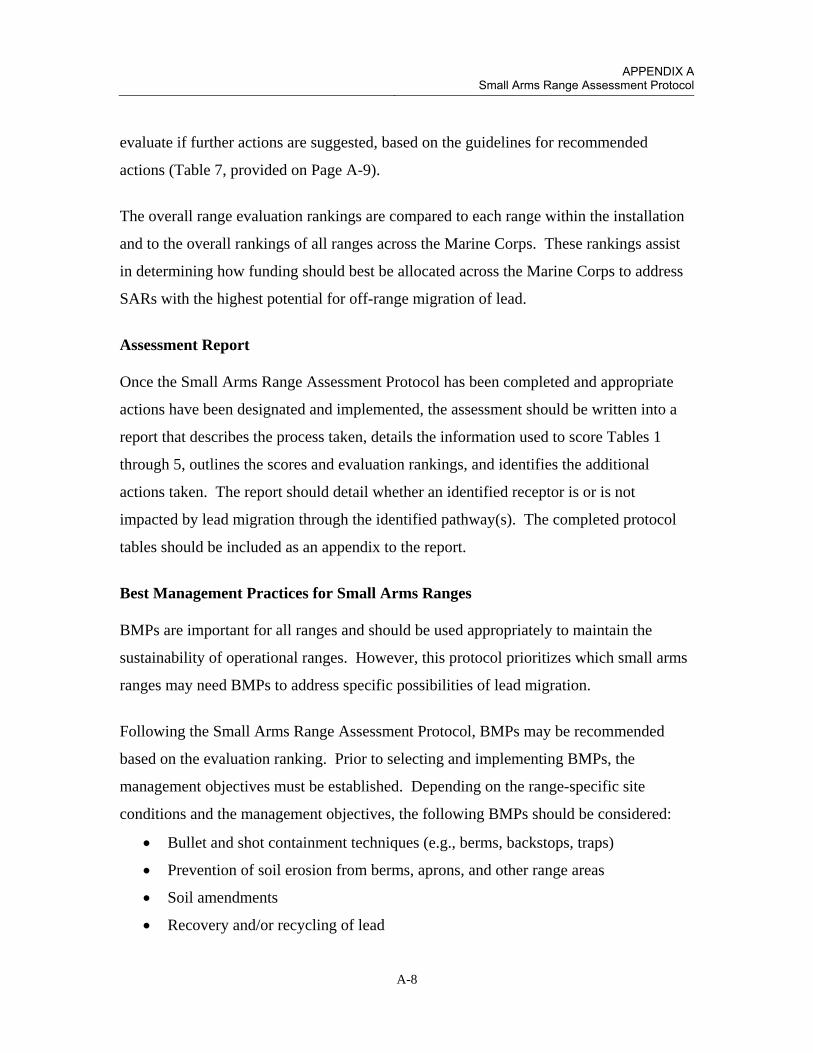
APPENDIX A
Small Arms Range Assessment Protocol
A-8
evaluate if further actions are suggested, based on the guidelines for recommended
actions (Table 7, provided on Page A-9).
The overall range evaluation rankings are compared to each range within the installation
and to the overall rankings of all ranges across the Marine Corps. These rankings assist
in determining how funding should best be allocated across the Marine Corps to address
SARs with the highest potential for off-range migration of lead.
Assessment Report
Once the Small Arms Range Assessment Protocol has been completed and appropriate
actions have been designated and implemented, the assessment should be written into a
report that describes the process taken, details the information used to score Tables 1
through 5, outlines the scores and evaluation rankings, and identifies the additional
actions taken. The report should detail whether an identified receptor is or is not
impacted by lead migration through the identified pathway(s). The completed protocol
tables should be included as an appendix to the report.
Best Management Practices for Small Arms Ranges
BMPs are important for all ranges and should be used appropriately to maintain the
sustainability of operational ranges. However, this protocol prioritizes which small arms
ranges may need BMPs to address specific possibilities of lead migration.
Following the Small Arms Range Assessment Protocol, BMPs may be recommended
based on the evaluation ranking. Prior to selecting and implementing BMPs, the
management objectives must be established. Depending on the range-specific site
conditions and the management objectives, the following BMPs should be considered:
Bullet and shot containment techniques (e.g., berms, backstops, traps)
Prevention of soil erosion from berms, aprons, and other range areas
Soil amendments
Recovery and/or recycling of lead
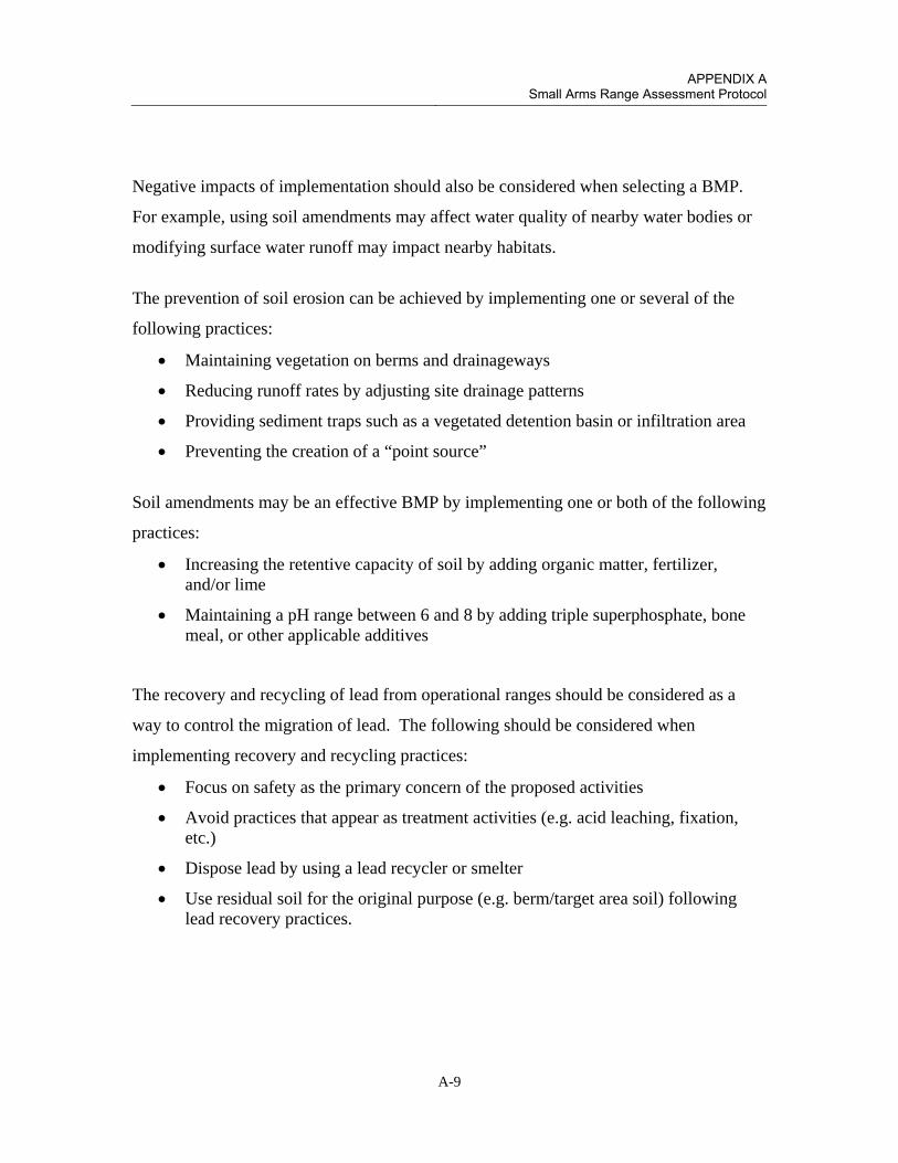
APPENDIX A
Small Arms Range Assessment Protocol
A-9
Negative impacts of implementation should also be considered when selecting a BMP.
For example, using soil amendments may affect water quality of nearby water bodies or
modifying surface water runoff may impact nearby habitats.
The prevention of soil erosion can be achieved by implementing one or several of the
following practices:
Maintaining vegetation on berms and drainageways
Reducing runoff rates by adjusting site drainage patterns
Providing sediment traps such as a vegetated detention basin or infiltration area
Preventing the creation of a “point source”
Soil amendments may be an effective BMP by implementing one or both of the following
practices:
Increasing the retentive capacity of soil by adding organic matter, fertilizer, and/or lime
Maintaining a pH range between 6 and 8 by adding triple superphosphate, bone meal, or other applicable additives
The recovery and recycling of lead from operational ranges should be considered as a
way to control the migration of lead. The following should be considered when
implementing recovery and recycling practices:
Focus on safety as the primary concern of the proposed activities
Avoid practices that appear as treatment activities (e.g. acid leaching, fixation, etc.)
Dispose lead by using a lead recycler or smelter
Use residual soil for the original purpose (e.g. berm/target area soil) following lead recovery practices.

APPENDIX A
Small Arms Range Assessment Protocol
A-10
Table A-1: Guidelines for Recommended Actions
Evaluation Ranking
Recommended Action
High
Action required.
1) Consider sampling appropriate media (groundwater, surface water, and/or soil).
2) Identify and implement BMPs, if necessary.
Moderate
1) Consider identifying and implementing BMPs, if necessary.
2) Consider sampling appropriate media (groundwater, surface water, and/or soil).
Minimal 1) No further action is needed at this time.
2) Consider identifying and implementing BMPs, if necessary.

APPENDIX A
Small Arms Range Assessment Protocol
A-11
SARAP Tables

APPENDIX A
Small Arms Range Assessment Protocol
A-12
This page left intentionally blank

APPENDIX A
Small Arms Range Assessment Protocol
A-13
Rifle Range MARINE CORPS LOGISTICS BASE BARSTOW BARSTOW, CALIFORNIA The Rifle Range is used for marksmanship training and (re)qualification of Marines at MCLB Barstow. This is a small arms range that primarily uses one type of small arms ammunition. The direction of fire is towards the west into an impact berm. Currently, the 25-, 200-, 300-, and 500-yard firing lines are used, and the 600- and 1000-yard firing lines are not. FIVE-YEAR REVIEW ASSESSMENT RESULTS: The surface water evaluation resulted in a minimal ranking (29 points). Range conditions presented in the following tables were evaluated using public databases, historical documentation, information gathered from interviews with installation personnel, and field observations made during the site visit. Lead loading is low, and the range is used only two to three times per month. Site conditions (low precipitation and high evaporation; neutral surface water and soil pH) and engineered controls minimize the potential for lead migration, and there is limited or no presence of receptors (no human receptors; limited potential exposure to ecological receptors). The groundwater evaluation resulted in a moderate ranking (31). This score was adjusted from moderate to minimal based on several factors. The moderate score is driven by the sandy soil conditions which promotes transport through the vadose zone to reach groundwater. The SARAP system does not account for extreme site characteristics such as desert conditions (low rainfall) as in the case of MCLB Barstow. Low range use and site conditions (low precipitation, high evaporation rate, neutral soil pH, depth to groundwater) minimize potential for lead to reach groundwater. In addition, there are limited receptor exposure points (groundwater wells).

APPENDIX A
Small Arms Range Assessment Protocol
A-14
MARINE CORPS LOGISTICS BASE BARSTOW RIFLE RANGE
Table 1: Range Use and Range Management (Source) Element (These definitions only apply for the purposes of the Small Arms Range Assessment Protocol.)
Criteria Evaluation Characteristics Score Criteria Site
Score
Duration of Range Use
Range used from 1955 to present.
5 if usage > 30 years
3 if usage is 10 to 30 years
1 if usage < 10 years
5
Bullet-Capturing Technology
There is an impact berm at the range, but no bullet-capturing technology has ever been in place at the range.
-3 if range usage duration = bullet capture duration
-1 if range usage duration – bullet capture
duration = 10 to 30 years
0 if range usage duration – bullet capture duration > 30 years, or no bullet capture
technology present.
0
MC Loading Rates
Approximately 279 pounds of lead per year are used at the rifle range.
5 if MC loading > 1000 pounds/year
3 if MC loading = 100 to 1000 pounds/year
1 if MC loading < 100 pounds/year
3
Range Maintenance
Lead removal was completed in August 2012. Lead removal is conducted on an as needed basis.
5 if lead is removed less than every three years
3 if lead is removed more than every three
years but less than annually
1 if lead is removed at least annually
5
Source Element Score 13
Notes:

APPENDIX A
Small Arms Range Assessment Protocol
A-15
MARINE CORPS LOGISTICS BASE BARSTOW RIFLE RANGE
Notes: Water quality data collected from United States Geological Survey (USGS) stream gages at Barstow (USGS stream gage 10262500) have field measured pH concentrations above 6.5. One water quality sample at Barstow had a pH of 7.8 (USGS, 2007).
Table 2: Surface Water Pathways Characteristics Element (These definitions only apply for the purposes of the Small Arms Range Assessment Protocol.)
Criteria Evaluation Characteristics Score Criteria Site
Score
pH of Water
Gaging stations in the Mojave hydrologic unit near MCLB Barstow for years ranging from 2009 through 2012 have an average field measured pH value of 8.1 and most frequently measured value of 8 (USGS, 2012).
5 if pH < 6.5
3 if pH > 8.5
1 if pH 6.5 ≤ pH ≤ 8.5
1
Precipitation Annual average precipitation is approximately 4.4 inches per year.
5 if precipitation > 40 inches/year
3 if precipitation = 20-40 inches/year
1 if precipitation < 20 inches/year
1
Slope of Range and Berm
Based on a visual survey, the slope of the berm is greater than 50%. The area in front of the berm is largely flat.
5 if slope > 10%
3 if slope = 5% to 10%
1 if slope < 5%
5
Vegetation There is very sparse scrub vegetation on the range.
5 if vegetation cover < 20%
3 if vegetation cover = 20% to 50%
1 if vegetation cover > 50%
5
Soil Type/Runoff Conditions
Soils are typically low in organic material and a mixture of sands: coarse sand, gravelly sand, and loamy sand.
5 if soil type is clay / silty clay
3 if soil type is clayey sand / silt
1 if soil type is sand/gravel
1
Runoff/ Erosion Engineering Controls
Sandbags were placed on top of the berm to minimize erosion, and backside of the berm was sloped to reduce run-on down the face of the berm. The front of the berm is graded to help reduce run-off velocity. Side berms help retain some of the run-off north of the range.
0 if no engineering controls
-5 if partial engineering controls
-10 if effective engineering controls
-5
Surface Water Pathway Score 8

APPENDIX A
Small Arms Range Assessment Protocol
A-16
MARINE CORPS LOGISTICS BASE BARSTOW RIFLE RANGE
Table 3: Groundwater Pathways Characteristics Element (These definitions only apply for the purposes of the Small Arms Range Assessment Protocol.)
Criteria Evaluation Characteristics Score
Criteria
Site Score
Depth to Groundwater
Studies conducted at an Installation Restoration Program site located approximately 1.5 miles northwest of the Rifle Range documented depth to water between 160 and 210 feet bgs. Depths up to 175 feet bgs have been noted on the alluvial fan south of Interstate 40 near the Rifle Range Complex (Jacobs Engineering, 1997; Tetra Tech, 2003).
5 if depth to groundwater < 20 feet
3 if depth to groundwater = 20-99 feet
1 if depth to groundwater = 100-300 feet
0 if depth to groundwater >300 feet
1
Precipitation Annual average precipitation is approximately 4.4 inches per year.
5 if precipitation > 40 inches/year
3 if precipitation = 20-40 inches/year
1 if precipitation < 20 inches/year
1
pH of Water
pH measurements averaged approximately 7.5 during 2011 groundwater sampling conducted at the installation.
5 if pH < 6.5
3 if pH > 8.5
1 if pH 6.5 ≤ pH ≤ 8.5
1
pH of Soil NCRS soil data suggest a pH between 7.4-8.4
5 if pH < 6.5
3 if pH > 8.5
1 if pH 6.5 ≤ pH ≤ 8.5
1
Soil Type/Infiltration Conditions
Soil type is sand.
5 if soil type is sand/gravel
3 if soil type is clayey sand / silt
1 if soil type is clay / silty clay
5
Clay Content in Soil
Little to no clay is present.
5 if soil type is sand/gravel
3 if soil type is clayey sand / silt
1 if soil type is clay / silty clay
5
Groundwater Pathway Score 14
Notes:

APPENDIX A
Small Arms Range Assessment Protocol
A-17
MARINE CORPS LOGISTICS BASE BARSTOW RIFLE RANGE
Table 4: Surface Water Receptors Element (These definitions only apply for the purposes of the Small Arms Range Assessment Protocol.)
Criteria Evaluation
Characteristics Score
Criteria
Site Score
Drinking Water Usage
The Mojave River is the primary surface water body in the area, and it is not used for drinking water; however, the Mojave River is connected with the Mojave River aquifer and the Regional aquifer.
10 if analytical data or observable evidence indicates that contamination in the media is present at, is moving toward, or has a reasonable potential to move toward a surface water body used as a potable water supply or if
a designation as a potable water source is unknown
5 if contamination in the media has moved or is expected to move only slightly beyond the source (tens of feet) or could move, but is not moving appreciably, toward surface water body used as a potable water
supply or if a designation as a potable water source is unknown
2 if low possibility for contamination in the media to be
present at or migrate to a point of exposure
2
Agricultural or Other Beneficial Usage
Because of the climate, minimal agriculture is conducted in the area. The closest known agricultural farms are approximately 10 miles east of the installation.
5 if analytical data or observable evidence indicates that contamination in the media is present at, is moving
toward, or has moved to a point of exposure or if a designation as agricultural or other beneficial usage is
unknown
3 if contamination in the media has moved only slightly beyond the source (tens of feet) or could move but is
not moving appreciably.
1 if low possibility for contamination in the media to be present at or migrate to a point of exposure
1
Sensitive Species Habitat and Threatened or Endangered Species
The desert tortoise is present in the range complex and could potentially access surface water (when flowing) and sediment. However, the infrequent rainfall is expected to limit the access to potentially contaminated media.
10 if identified receptors have access to possibly contaminated media and/or are located adjacent to the
range boundary
5 if potential for receptors to have access to possibly contaminated media
1 if little or no potential for receptors to have access to
possible contaminated media
5
Surface Water Receptor Score 8
Notes:

APPENDIX A
Small Arms Range Assessment Protocol
A-18
MARINE CORPS LOGISTICS BASE BARSTOW RIFLE RANGE
Table 5: Groundwater Receptors Element (These definitions only apply for the purposes of the Small Arms Range Assessment Protocol.)
Criteria Evaluation
Characteristics Score
Criteria
Site Score
Wells Identified as Potable Water Sources
The closest potable water supply wells are located at the Yermo Annex . A fault prevents groundwater from the Rifle Range complex from reaching groundwater serving the potable wells.
10 if analytical data or observable evidence or site conditions indicate that MC may be within or moving toward a reasonable radius of influence of a well or
other point of exposure or if a designation as a potable water source is unknown
5 if analytical data or observable evidence or site
conditions indicate that MC have moved only slightly beyond the source (tens of feet) or could move toward
a reasonable radius of influence of a well or other point of exposure, but are not moving appreciably
2 if low possibility for MC to be present at or migrate to within a reasonable radius of influence or point of
exposure
2
Wells Identified for Agricultural or Other Beneficial Usage
Groundwater supply wells for the MCLB golf course are located cross-gradient from the rifle range. The closest non-potable well is over one mile from the pistol range.
5 if analytical data or observable evidence or site conditions indicate that MC may be within or moving toward a reasonable radius of influence of a well or
other point of exposure or if a designation as agricultural or other beneficial usage is unknown
3 if analytical data or observable evidence or site
conditions indicate that MC have moved only slightly beyond the source (tens of feet) or could move toward
a reasonable radius of influence of a well or other point of exposure, but are not moving appreciably
1 if low possibility for MC to be present at or migrate to within a reasonable radius of influence of a well or
point of exposure
1
Sensitive Species Habitat and Threatened and Endangered Species
The desert tortoise is present in the area, but there are no known points where it could access groundwater.
5 if identified receptors exposed to potentially MC-impacted water from groundwater or groundwater
sources
3 if potential for receptors exposed to potentially MC-impacted water from groundwater or groundwater
sources
1 if little or no potential for receptors exposed to potentially MC-impacted water from groundwater or
groundwater sources
1
Groundwater Receptor Score 4
Notes:
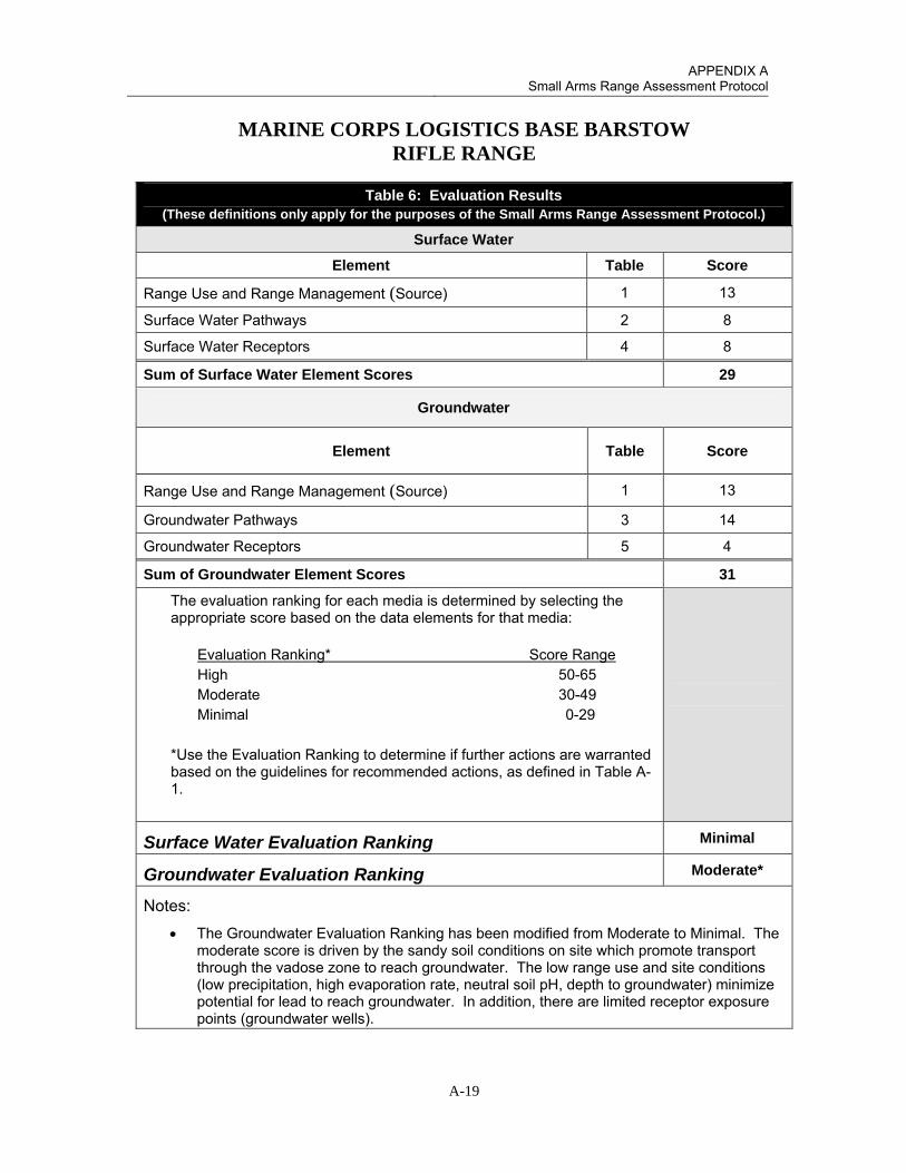
APPENDIX A
Small Arms Range Assessment Protocol
A-19
MARINE CORPS LOGISTICS BASE BARSTOW RIFLE RANGE
Table 6: Evaluation Results (These definitions only apply for the purposes of the Small Arms Range Assessment Protocol.)
Surface Water
Element Table Score
Range Use and Range Management (Source) 1 13
Surface Water Pathways 2 8
Surface Water Receptors 4 8
Sum of Surface Water Element Scores 29
Groundwater
Element Table Score
Range Use and Range Management (Source) 1 13
Groundwater Pathways 3 14
Groundwater Receptors 5 4
Sum of Groundwater Element Scores 31
The evaluation ranking for each media is determined by selecting the appropriate score based on the data elements for that media:
Evaluation Ranking* Score Range High 50-65 Moderate 30-49 Minimal 0-29
*Use the Evaluation Ranking to determine if further actions are warranted based on the guidelines for recommended actions, as defined in Table A-1.
Surface Water Evaluation Ranking Minimal
Groundwater Evaluation Ranking Moderate*
Notes:
The Groundwater Evaluation Ranking has been modified from Moderate to Minimal. The moderate score is driven by the sandy soil conditions on site which promote transport through the vadose zone to reach groundwater. The low range use and site conditions (low precipitation, high evaporation rate, neutral soil pH, depth to groundwater) minimize potential for lead to reach groundwater. In addition, there are limited receptor exposure points (groundwater wells).

APPENDIX A
Small Arms Range Assessment Protocol
A-20
Pistol Range MARINE CORPS LOGISTICS BASE BARSTOW BARSTOW, CALIFORNIA The Pistol Range is used for marksmanship training and (re)qualification of Marines at MCLB Barstow. This range uses five types of small arms ammunition. There are 12 firing points and a maximum firing distance of 50 yards. FIVE-YEAR REVIEW ASSESSMENT RESULTS: The Surface Water Ranking is Minimal. Range conditions presented in the following tables were evaluated using sampling data from the 2005 sampling event, public databases, historical documentation, installation personnel interviews, and field observations made during the site visit. Lead loading is low, and the range is used only two to three times per month. Site conditions (low precipitation and high evaporation; neutral surface water and soil pH) minimize the potential for lead migration, and there is limited or no presence of receptors (no human receptors; limited potential exposure to ecological receptors). The groundwater evaluation resulted in a moderate ranking (31). This score was adjusted from moderate to minimal based on several factors. The moderate score is driven by the sandy soil conditions which promotes transport through the vadose zone to reach groundwater. The SARAP system does not account for extreme site characteristics such as desert conditions (low rainfall) as in the case of MCLB Barstow. Low range use and site conditions (low precipitation, high evaporation rate, neutral soil pH, depth to groundwater) minimize potential for lead to reach groundwater. In addition, there are limited receptor exposure points (groundwater wells).

APPENDIX A
Small Arms Range Assessment Protocol
A-21
MARINE CORPS LOGISTICS BASE BARSTOW PISTOL RANGE
Table 1: Range Use and Range Management (Source) Element (These definitions only apply for the purposes of the Small Arms Range Assessment Protocol.)
Criteria Evaluation Characteristics Score Criteria Site
Score
Duration of Range Use
Range used from 1955 to present.
5 if usage > 30 years
3 if usage is 10 to 30 years
1 if usage < 10 years
5
Bullet-Capturing Technology
There is an impact berm at the range, but no bullet-capturing technology has ever been in place at the range.
-3 if range usage duration = bullet capture duration
-1 if range usage duration – bullet capture
duration = 10 to 30 years
0 if range usage duration – bullet capture duration > 30 years, or no bullet capture
technology present.
0
MC Loading Rates
Approximately 359 pounds of lead per year are used at the pistol range.
5 if MC loading > 1000 pounds/year
3 if MC loading = 100 to 1000 pounds/year
1 if MC loading < 100 pounds/year
3
Range Maintenance
Lead removal was completed in August 2012. Lead removal is conducted on an as needed basis.
5 if lead is removed less than every three years
3 if lead is removed more than every three
years but less than annually
1 if lead is removed at least annually
5
Source Element Score 13
Notes:

APPENDIX A
Small Arms Range Assessment Protocol
A-22
MARINE CORPS LOGISTICS BASE BARSTOW PISTOL RANGE
Notes: Water quality data collected from United States Geological Survey (USGS) stream gages at Barstow (USGS stream gage 10262500) have field measured pH concentrations above 6.5. One water quality sample at Barstow had a pH of 7.8 (USGS, 2007).
Table 2: Surface Water Pathways Characteristics Element (These definitions only apply for the purposes of the Small Arms Range Assessment Protocol.)
Criteria Evaluation Characteristics Score Criteria Site
Score
pH of Water
Gaging stations in the Mojave hydrologic unit near MCLB Barstow for years ranging from 2009 through 2012 have an average field measured pH value of 8.1 and most frequently measured value of 8 (USGS, 2012).
5 if pH < 6.5
3 if pH > 8.5
1 if pH 6.5 ≤ pH ≤ 8.5
1
Precipitation Annual average precipitation is approximately 4.4 inches per year.
5 if precipitation > 40 inches/year
3 if precipitation = 20-40 inches/year
1 if precipitation < 20 inches/year
1
Slope of Range and Berm
Based on a visual survey, the slope of the berm is approximately 22.5 degrees. The range is largely flat.
5 if slope > 10%
3 if slope = 5% to 10%
1 if slope < 5%
5
Vegetation There is virtually no vegetation on the range. A few scrub bushes are present on side berms but are very sparse.
5 if vegetation cover < 20%
3 if vegetation cover = 20% to 50%
1 if vegetation cover > 50%
5
Soil Type/Runoff Conditions
Soils are typically low in organic material and a mixture of sands: coarse sand, gravelly sand, and loamy sand.
5 if soil type is clay / silty clay
3 if soil type is clayey sand / silt
1 if soil type is sand/gravel
1
Runoff/ Erosion Engineering Controls
A wall of sandbags is present at the foot of the berm in an effort to control sand that could potentially erode down the berm. The top of the berm is slightly sloped towards the back to prevent run on down the face of the berm. The back and side berms are present at the range which minimize run-on to the range.
0 if no engineering controls
-5 if partial engineering controls
-10 if effective engineering controls
-5
Surface Water Pathway Score 8

APPENDIX A
Small Arms Range Assessment Protocol
A-23
MARINE CORPS LOGISTICS BASE BARSTOW PISTOL RANGE
Table 3: Groundwater Pathways Characteristics Element (These definitions only apply for the purposes of the Small Arms Range Assessment Protocol.)
Criteria Evaluation Characteristics Score
Criteria
Site Score
Depth to Groundwater
Studies conducted at an Installation Restoration Program site located approximately 1.5 miles northwest of the Rifle Range documented depth to water between 160 and 210 feet bgs. Depths up to 175 feet bgs have been noted on the alluvial fan south of Interstate 40 near the Rifle Range Complex (Jacobs Engineering, 1997; Tetra Tech, 2003).
5 if depth to groundwater < 20 feet
3 if depth to groundwater = 20-99 feet
1 if depth to groundwater = 100-300 feet
0 if depth to groundwater >300 feet
1
Precipitation Annual average precipitation is approximately 4.4 inches per year.
5 if precipitation > 40 inches/year
3 if precipitation = 20-40 inches/year
1 if precipitation < 20 inches/year
1
pH of Water
pH measurements averaged approximately 7.5 during 2011 groundwater sampling conducted at the installation.
5 if pH < 6.5
3 if pH > 8.5
1 if pH 6.5 ≤ pH ≤ 8.5
1
pH of Soil NCRS soil data suggest a pH between 7.4-8.4
5 if pH < 6.5
3 if pH > 8.5
1 if pH 6.5 ≤ pH ≤ 8.5
1
Soil Type/Infiltration Conditions
Soil type is sand.
5 if soil type is sand/gravel
3 if soil type is clayey sand / silt
1 if soil type is clay / silty clay
5
Clay Content in Soil
Little to no clay is present.
5 if soil type is sand/gravel
3 if soil type is clayey sand / silt
1 if soil type is clay / silty clay
5
Groundwater Pathway Score 14
Notes:

APPENDIX A
Small Arms Range Assessment Protocol
A-24
MARINE CORPS LOGISTICS BASE BARSTOW PISTOL RANGE
Table 4: Surface Water Receptors Element (These definitions only apply for the purposes of the Small Arms Range Assessment Protocol.)
Criteria Evaluation
Characteristics Score
Criteria
Site Score
Drinking Water Usage
The Mojave River is the primary surface water body in the area, and it is not used for drinking water; however, the Mojave River is connected with the Mojave River aquifer and the Regional aquifer.
10 if analytical data or observable evidence indicates that contamination in the media is present at, is moving toward, or has a reasonable potential to move toward a surface water body used as a potable water supply or if
a designation as a potable water source is unknown
5 if contamination in the media has moved or is expected to move only slightly beyond the source (tens of feet) or could move, but is not moving appreciably, toward surface water body used as a potable water
supply or if a designation as a potable water source is unknown
2 if low possibility for contamination in the media to be
present at or migrate to a point of exposure
2
Agricultural or Other Beneficial Usage
Because of the climate, minimal agriculture is conducted in the area. The closest known agricultural farms are approximately 10 miles east of the installation.
5 if analytical data or observable evidence indicates that contamination in the media is present at, is moving
toward, or has moved to a point of exposure or if a designation as agricultural or other beneficial usage is
unknown
3 if contamination in the media has moved only slightly beyond the source (tens of feet) or could move but is
not moving appreciably.
1 if low possibility for contamination in the media to be present at or migrate to a point of exposure
1
Sensitive Species Habitat and Threatened or Endangered Species
The desert tortoise is present in the range complex and could potentially access surface water (when flowing) and sediment. However, the infrequent rainfall is expected to limit the access to potentially contaminated media.
10 if identified receptors have access to possibly contaminated media and/or are located adjacent to the
range boundary
5 if potential for receptors to have access to possibly contaminated media
1 if little or no potential for receptors to have access to
possible contaminated media
5
Surface Water Receptor Score 8
Notes:

APPENDIX A
Small Arms Range Assessment Protocol
A-25
MARINE CORPS LOGISTICS BASE BARSTOW PISTOL RANGE
Table 5: Groundwater Receptors Element (These definitions only apply for the purposes of the Small Arms Range Assessment Protocol.)
Criteria Evaluation
Characteristics Score
Criteria
Site Score
Wells Identified as Potable Water Sources
The closest potable water supply wells are located at the Yermo Annex which . A fault prevents groundwater from the Rifle Range complex from reaching groundwater serving the potable wells.
10 if analytical data or observable evidence or site conditions indicate that MC may be within or moving toward a reasonable radius of influence of a well or
other point of exposure or if a designation as a potable water source is unknown
5 if analytical data or observable evidence or site
conditions indicate that MC have moved only slightly beyond the source (tens of feet) or could move toward
a reasonable radius of influence of a well or other point of exposure, but are not moving appreciably
2 if low possibility for MC to be present at or migrate to within a reasonable radius of influence or point of
exposure
2
Wells Identified for Agricultural or Other Beneficial Usage
Groundwater supply wells for the MCLB golf course are located cross-gradient from the pistol range. The closest non-potable well is over one mile from the pistol range.
5 if analytical data or observable evidence or site conditions indicate that MC may be within or moving toward a reasonable radius of influence of a well or
other point of exposure or if a designation as agricultural or other beneficial usage is unknown
3 if analytical data or observable evidence or site
conditions indicate that MC have moved only slightly beyond the source (tens of feet) or could move toward
a reasonable radius of influence of a well or other point of exposure, but are not moving appreciably
1 if low possibility for MC to be present at or migrate to within a reasonable radius of influence of a well or
point of exposure
1
Sensitive Species Habitat and Threatened and Endangered Species
The desert tortoise is present in the area, but there are no known points where it could access groundwater.
5 if identified receptors exposed to potentially MC-impacted water from groundwater or groundwater
sources
3 if potential for receptors exposed to potentially MC-impacted water from groundwater or groundwater
sources
1 if little or no potential for receptors exposed to potentially MC-impacted water from groundwater or
groundwater sources
1
Groundwater Receptor Score 4
Notes:

APPENDIX A
Small Arms Range Assessment Protocol
A-26
MARINE CORPS LOGISTICS BASE BARSTOW PISTOL RANGE
Table 6: Evaluation Results (These definitions only apply for the purposes of the Small Arms Range Assessment Protocol.)
Surface Water
Element Table Score
Range Use and Range Management (Source) 1 13
Surface Water Pathways 2 8
Surface Water Receptors 4 8
Sum of Surface Water Element Scores 29
Groundwater
Element Table Score
Range Use and Range Management (Source) 1 13
Groundwater Pathways 3 14
Groundwater Receptors 5 4
Sum of Groundwater Element Scores 31
The evaluation ranking for each media is determined by selecting the appropriate score based on the data elements for that media:
Evaluation Ranking* Score Range High 50-65 Moderate 30-49 Minimal 0-29
*Use the Evaluation Ranking to determine if further actions are warranted based on the guidelines for recommended actions, as defined in Table A-1.
Surface Water Evaluation Ranking Minimal
Groundwater Evaluation Ranking Moderate*
Notes:
* The Groundwater Evaluation Ranking has been modified from Moderate to Minimal. The moderate score is driven by the sandy soil conditions on site which promote transport through the vadose zone to reach groundwater. The low range use and site conditions (low precipitation, high evaporation rate, neutral soil pH, depth to groundwater) minimize potential for lead to reach groundwater. In addition, there are limited receptor exposure points (groundwater wells).

APPENDIX A
Small Arms Range Assessment Protocol
A-27
Shotgun Range MARINE CORPS LOGISTICS BASE BARSTOW BARSTOW, CALIFORNIA The Shotgun Range is used for marksmanship training and (re)qualification of Marines at MCLB Barstow. The range uses four types of small arms ammunition. There are 20 firing points and a maximum firing distance of 100 yards. FIVE-YEAR REVIEW ASSESSMENT RESULTS: The Surface Water Ranking is Minimal. Range conditions presented in the following tables were evaluated using public databases, historical documentation, installation personnel interviews, and field observations made during the site visit. Lead loading is low. Site conditions (low precipitation and high evaporation; neutral surface water and soil pH) minimize the potential for lead migration, and there is limited or no presence of receptors (no human receptors; limited potential exposure to ecological receptors). The groundwater evaluation resulted in a minimal ranking. Low range use and site conditions (low precipitation, high evaporation rate, neutral soil pH) minimize potential for lead to reach
groundwater. In addition, there are limited receptor exposure points (groundwater wells).

APPENDIX A
Small Arms Range Assessment Protocol
A-28
MARINE CORPS LOGISTICS BASE BARSTOW SHOTGUN RANGE
Table 1: Range Use and Range Management (Source) Element (These definitions only apply for the purposes of the Small Arms Range Assessment Protocol.)
Criteria Evaluation Characteristics Score Criteria Site
Score
Duration of Range Use
Range used from 1955 to present.
5 if usage > 30 years
3 if usage is 10 to 30 years
1 if usage < 10 years
5
Bullet-Capturing Technology
There is an impact berm at the range, but no bullet-capturing technology has ever been in place at the range.
-3 if range usage duration = bullet capture duration
-1 if range usage duration – bullet capture
duration = 10 to 30 years
0 if range usage duration – bullet capture duration > 30 years, or no bullet capture
technology present.
0
MC Loading Rates
Approximately 92 pounds of lead per year are used at the shotgun range.
5 if MC loading > 1000 pounds/year
3 if MC loading = 100 to 1000 pounds/year
1 if MC loading < 100 pounds/year
1
Range Maintenance
Lead removal was completed in August 2012. Lead removal is conducted on an as needed basis..
5 if lead is removed less than every three years
3 if lead is removed more than every three
years but less than annually
1 if lead is removed at least annually
5
Source Element Score 11
Notes:

APPENDIX A
Small Arms Range Assessment Protocol
A-29
MARINE CORPS LOGISTICS BASE BARSTOW SHOTGUN RANGE
Notes: Water quality data collected from United States Geological Survey (USGS) stream gages at Barstow (USGS stream gage 10262500) have field measured pH concentrations above 6.5. One water quality sample at Barstow had a pH of 7.8 (USGS, 2007).
Table 2: Surface Water Pathways Characteristics Element (These definitions only apply for the purposes of the Small Arms Range Assessment Protocol.)
Criteria Evaluation Characteristics Score Criteria Site
Score
pH of Water
Gaging stations in the Mojave hydrologic unit near MCLB Barstow for years ranging from 2009 through 2012 have an average field measured pH value of 8.1 and most frequently measured value of 8 (USGS, 2012).
5 if pH < 6.5
3 if pH > 8.5
1 if pH 6.5 ≤ pH ≤ 8.5
1
Precipitation Annual average precipitation is approximately 4.4 inches per year.
5 if precipitation > 40 inches/year
3 if precipitation = 20-40 inches/year
1 if precipitation < 20 inches/year
1
Slope of Range and Berm
Based on a visual survey, the slope of the berm is approximately 22.5 degrees. The range is largely flat.
5 if slope > 10%
3 if slope = 5% to 10%
1 if slope < 5%
5
Vegetation There is very sparse scrub vegetation on the range.
5 if vegetation cover < 20%
3 if vegetation cover = 20% to 50%
1 if vegetation cover > 50%
5
Soil Type/Runoff Conditions
Soils are typically low in organic material and a mixture of sands: coarse sand, gravelly sand, and loamy sand.
5 if soil type is clay / silty clay
3 if soil type is clayey sand / silt
1 if soil type is sand/gravel
1
Runoff/ Erosion Engineering Controls
A wall of sandbags is present at the foot of the berm in an effort to control sand that could potentially erode down the berm. The top of the berm is slightly sloped towards the back to prevent run on down the face of the berm. The back and side berms are present at the range which minimize run-on to the range.
0 if no engineering controls
-5 if partial engineering controls
-10 if effective engineering controls
-5
Surface Water Pathway Score 8

APPENDIX A
Small Arms Range Assessment Protocol
A-30
MARINE CORPS LOGISTICS BASE BARSTOW SHOTGUN RANGE
Table 3: Groundwater Pathways Characteristics Element (These definitions only apply for the purposes of the Small Arms Range Assessment Protocol.)
Criteria Evaluation Characteristics Score
Criteria
Site Score
Depth to Groundwater
Studies conducted at an Installation Restoration Program site located approximately 1.5 miles northwest of the Rifle Range documented depth to water between 160 and 210 feet bgs. Depths up to 175 feet bgs have been noted on the alluvial fan south of Interstate 40 near the Rifle Range Complex (Jacobs Engineering, 1997; Tetra Tech, 2003).
5 if depth to groundwater < 20 feet
3 if depth to groundwater = 20-99 feet
1 if depth to groundwater = 100-300 feet
0 if depth to groundwater >300 feet
1
Precipitation Annual average precipitation is approximately 4.4 inches per year.
5 if precipitation > 40 inches/year
3 if precipitation = 20-40 inches/year
1 if precipitation < 20 inches/year
1
pH of Water
pH measurements averaged approximately 7.5 during 2011 groundwater sampling conducted at the installation.
5 if pH < 6.5
3 if pH > 8.5
1 if pH 6.5 ≤ pH ≤ 8.5
1
pH of Soil NCRS soil data suggest a pH between 7.4-8.4
5 if pH < 6.5
3 if pH > 8.5
1 if pH 6.5 ≤ pH ≤ 8.5
1
Soil Type/Infiltration Conditions
Soil type is sand.
5 if soil type is sand/gravel
3 if soil type is clayey sand / silt
1 if soil type is clay / silty clay
5
Clay Content in Soil
Little to no clay is present.
5 if soil type is sand/gravel
3 if soil type is clayey sand / silt
1 if soil type is clay / silty clay
5
Groundwater Pathway Score 14
Notes:

APPENDIX A
Small Arms Range Assessment Protocol
A-31
MARINE CORPS LOGISTICS BASE BARSTOW SHOTGUN RANGE
Table 4: Surface Water Receptors Element (These definitions only apply for the purposes of the Small Arms Range Assessment Protocol.)
Criteria Evaluation
Characteristics Score
Criteria
Site Score
Drinking Water Usage
The Mojave River is the primary surface water body in the area, and it is not used for drinking water; however, the Mojave River is connected with the Mojave River aquifer and the Regional aquifer.
10 if analytical data or observable evidence indicates that contamination in the media is present at, is moving toward, or has a reasonable potential to move toward a surface water body used as a potable water supply or if
a designation as a potable water source is unknown
5 if contamination in the media has moved or is expected to move only slightly beyond the source (tens of feet) or could move, but is not moving appreciably, toward surface water body used as a potable water
supply or if a designation as a potable water source is unknown
2 if low possibility for contamination in the media to be
present at or migrate to a point of exposure
2
Agricultural or Other Beneficial Usage
Because of the climate, minimal agriculture is conducted in the area. The closest known agricultural farms are approximately 10 miles east of the installation.
5 if analytical data or observable evidence indicates that contamination in the media is present at, is moving
toward, or has moved to a point of exposure or if a designation as agricultural or other beneficial usage is
unknown
3 if contamination in the media has moved only slightly beyond the source (tens of feet) or could move but is
not moving appreciably.
1 if low possibility for contamination in the media to be present at or migrate to a point of exposure
1
Sensitive Species Habitat and Threatened or Endangered Species
The desert tortoise is present in the range complex and could potentially access surface water, when flowing. However, the infrequent rainfall is expected to limit the access to potentially contaminated range use.
10 if identified receptors have access to possibly contaminated media and/or are located adjacent to the
range boundary
5 if potential for receptors to have access to possibly contaminated media
1 if little or no potential for receptors to have access to
possible contaminated media
5
Surface Water Receptor Score 8
Notes:

APPENDIX A
Small Arms Range Assessment Protocol
A-32
MARINE CORPS LOGISTICS BASE BARSTOW SHOTGUN RANGE
Table 5: Groundwater Receptors Element (These definitions only apply for the purposes of the Small Arms Range Assessment Protocol.)
Criteria Evaluation
Characteristics Score
Criteria
Site Score
Wells Identified as Potable Water Sources
The closest potable water supply wells are located at the Yermo Annex . A fault prevents groundwater from the Rifle Range complex from reaching groundwater serving the potable wells..
10 if analytical data or observable evidence or site conditions indicate that MC may be within or moving toward a reasonable radius of influence of a well or
other point of exposure or if a designation as a potable water source is unknown
5 if analytical data or observable evidence or site
conditions indicate that MC have moved only slightly beyond the source (tens of feet) or could move toward
a reasonable radius of influence of a well or other point of exposure, but are not moving appreciably
2 if low possibility for MC to be present at or migrate to within a reasonable radius of influence or point of
exposure
2
Wells Identified for Agricultural or Other Beneficial Usage
Groundwater supply wells for the MCLB golf course are located cross-gradient from the shotgun range. The closest non-potable well is over one mile from the shotgun range.
5 if analytical data or observable evidence or site conditions indicate that MC may be within or moving toward a reasonable radius of influence of a well or
other point of exposure or if a designation as agricultural or other beneficial usage is unknown
3 if analytical data or observable evidence or site
conditions indicate that MC have moved only slightly beyond the source (tens of feet) or could move toward
a reasonable radius of influence of a well or other point of exposure, but are not moving appreciably
1 if low possibility for MC to be present at or migrate to within a reasonable radius of influence of a well or
point of exposure
1
Sensitive Species Habitat and Threatened and Endangered Species
The desert tortoise is present in the area, but there are no known points where it could access groundwater.
5 if identified receptors exposed to potentially MC-impacted water from groundwater or groundwater
sources
3 if potential for receptors exposed to potentially MC-impacted water from groundwater or groundwater
sources
1 if little or no potential for receptors exposed to potentially MC-impacted water from groundwater or
groundwater sources
1
Groundwater Receptor Score 4
Notes:

APPENDIX A
Small Arms Range Assessment Protocol
A-33
MARINE CORPS LOGISTICS BASE BARSTOW SHOTGUN RANGE
Table 6: Evaluation Results (These definitions only apply for the purposes of the Small Arms Range Assessment Protocol.)
Surface Water
Element Table Score
Range Use and Range Management (Source) 1 11
Surface Water Pathways 2 8
Surface Water Receptors 4 8
Sum of Surface Water Element Scores 27
Groundwater
Element Table Score
Range Use and Range Management (Source) 1 11
Groundwater Pathways 3 14
Groundwater Receptors 5 4
Sum of Groundwater Element Scores 29
The evaluation ranking for each media is determined by selecting the appropriate score based on the data elements for that media:
Evaluation Ranking* Score Range High 50-65 Moderate 30-49 Minimal 0-29
*Use the Evaluation Ranking to determine if further actions are warranted based on the guidelines for recommended actions, as defined in Table A-1.
Surface Water Evaluation Ranking Minimal
Groundwater Evaluation Ranking Minimal
Notes:

Marine Corps Installations Command Range Environmental Vulnerability Assessment 5-Year Report MCLB Barstow
B
Appendix B
Photographic Log

B-1
PISTOL RANGE
Photographic Log
Project: MCLB Barstow
Location: Barstow, California Project No. 06285037.0000
Photo No. 1
Date: 3-22-2012
Description: Pistol Range; View downrange during March 2012 site visit.
Photographic Log
Project: MCLB Barstow
Location: Barstow, California Project No. 06285037.0000
Photo No. 2
Date: 3-22-2012
Description: Pistol Range; View downrange during March 2012 site visit.

B-2
Photographic Log
Project: MCLB Barstow
Location: Barstow, California Project No. 06285037.0000
Photo No. 4
Date: 3-22-2012
Description: Pistol Range: target carriages and berm during March 2012 site visit.
Photographic Log
Project: MCLB Barstow
Location: Barstow, California Project No. 06285037.0000
Photo No. 5
Date: 3-22-2012
Description: Pistol Range: berm face during March 2012 site visit.

B-3
Photographic Log
Project: MCLB Barstow
Location: Barstow, California Project No. 06285037.0000
Photo No. 6
Date: 3-22-2012
Description: Pistol Range: Top of berm, note slope away from the face of the berm, and flat terrace. March 2012 site visit.
Photographic Log
Project: MCLB Barstow
Location: Barstow, California Project No. 06285037.0000
Photo No. 7
Date: 3-22-2012
Description: Pistol Range, behind berm during March 2012 site visit.

B-4
Photographic Log
Project: MCLB Barstow
Location: Barstow, California Project No. 06285037.0000
Photo No. 8
Date: 3-22-2012
Description: Pistol Range: View from top of berm towards firing positions during March 2012 site visit.
Photographic Log
Project: MCLB Barstow
Location: Barstow, California Project No. 06285037.0000
Photo No. 9
Date: August 2012
Description: Pistol Range: View downrange after lead mining and berm resurfacing action in August 2012.

B-5
Photographic Log
Project: MCLB Barstow
Location: Barstow, California Project No. 06285037.0000
Photo No. 10
Date: August 2012
Description: Pistol Range after lead mining and berm reshaping. Note ballistic block retaining walls to reduce ricochet.
Photographic Log
Project: MCLB Barstow
Location: Barstow, California Project No. 06285037.0000
Photo No. 11
Date: August 2012
Description: Pistol Range after lead mining and berm reshaping. Ballistic block used at the berm retaining wall.

B-6
Photographic Log
Project: MCLB Barstow
Location: Barstow, California Project No. 06285037.0000
Photo No. 12
Date: August 2012
Description: Pistol Range: Base of retaining wall. Note the erosion matting (Envirogrid) used to minimize erosion.
Photographic Log
Project: MCLB Barstow
Location: Barstow, California Project No. 06285037.0000
Photo No. 13
Date: August 2012
Description: First set of Ballistic Panel Clamed and Curing at Pistol Range

B-7
Shotgun Range
Photographic Log
Project: MCLB Barstow
Location: Barstow, California Project No. 06285037.0000
Photo No. 14
Date: 3-22-2012
Description: Shotgun Range: view from on top of pistol range berm looking at shotgun range targets and berm during March 2012 site visit.
Photographic Log
Project: MCLB Barstow
Location: Barstow, California Project No. 06285037.0000
Photo No. 15
Date: 3-22-2012
Description: Shotgun Range: view from Pistol Range berm looking uprange toward firing locations during March 2012 site visit.
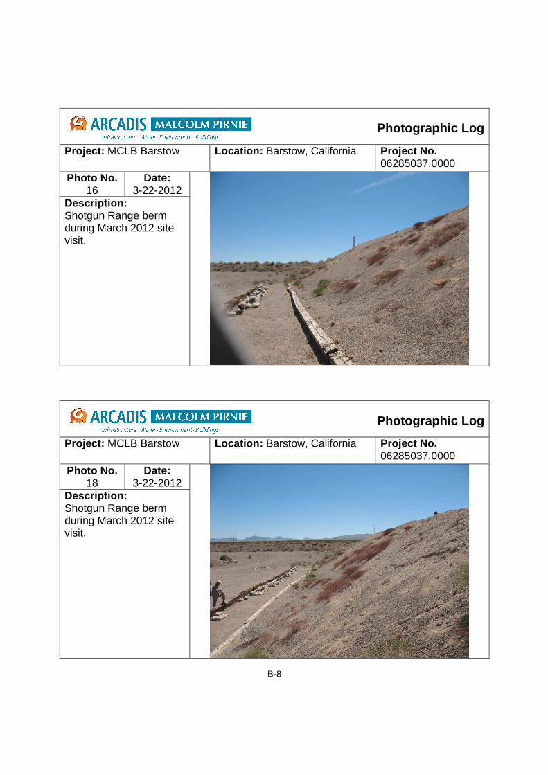
B-8
Photographic Log
Project: MCLB Barstow
Location: Barstow, California Project No. 06285037.0000
Photo No. 16
Date: 3-22-2012
Description: Shotgun Range berm during March 2012 site visit.
Photographic Log
Project: MCLB Barstow
Location: Barstow, California Project No. 06285037.0000
Photo No. 18
Date: 3-22-2012
Description: Shotgun Range berm during March 2012 site visit.

B-9
Photographic Log
Project: MCLB Barstow
Location: Barstow, California Project No. 06285037.0000
Photo No. 19
Date: 3-22-2012
Description: Shotgun Range: top of berm during March 2012 site visit. Note slight slop away from berm face.
Photographic Log
Project: MCLB Barstow
Location: Barstow, California Project No. 06285037.0000
Photo No. 20
Date: 3-22-2012
Description: Shotgun Range: view of the back of the berm, notice terrace down to road bed.

B-10
Photographic Log
Project: MCLB Barstow
Location: Barstow, California Project No. 06285037.0000
Photo No. 22
Date: 3-22-2012
Description: Shotgun Range: View from top of Shotgun Range berm towards firing points.
Photographic Log
Project: MCLB Barstow
Location: Barstow, California Project No. 06285037.0000
Photo No. 23
Date: 3-22-2012
Description: Behind Shotgun Range berm during March 2012 site visit.

B-11
Photographic Log
Project: MCLB Barstow
Location: Barstow, California Project No. 06285037.0000
Photo No. 25
Date: August 2012
Description: Shotgun Range: View after berm mining and resurfacing in August 2012. View is from berm towards firing position of completed Shotgun Range as prepped for Shotgun Pistol Qualification.
Photographic Log
Project: MCLB Barstow
Location: Barstow, California Project No. 06285037.0000
Photo No. 26
Date: August 2012
Description: Shotgun Range: Side view of EnviroGrid on Shotgun Berm during lead resurfacing in August 2012.

B-12
Photographic Log
Project: MCLB Barstow
Location: Barstow, California Project No. 06285037.0000
Photo No. 27
Date: August 2012
Description: Top view of EnviroGrid on Shotgun Berm during berm resurfacing in August 2012.

B-13
Rifle Range
Photographic Log
Project: MCLB Barstow
Location: Barstow, California Project No. 06285037.0000
Photo No. 28
Date: 3-22-2012
Description: Rifle Range: View from 500 foot firing position towards targets during March 2012 site visit.
Photographic Log
Project: MCLB Barstow
Location: Barstow, California Project No. 06285037.0000
Photo No. 24
Date: 3-22-2012
Description: Rifle Range 500 foot firing position on March 2012 site visit.

B-14
Photographic Log
Project: MCLB Barstow
Location: Barstow, California Project No. 06285037.0000
Photo No. 29
Date: 3-22-2012
Description: Rifle Range: Surface water drainage observed on Rifle Range during March 2012 site visit.
Photographic Log
Project: MCLB Barstow
Location: Barstow, California Project No. 06285037.0000
Photo No. 30
Date: 3-22-2012
Description: Rifle Range: Surface water drainage observed on Rifle Range during March 2012 site visit.

B-15
Photographic Log
Project: MCLB Barstow
Location: Barstow, California Project No. 06285037.0000
Photo No. 31
Date: 3-22-2012
Description: Rifle Range: Targets and impact berm observed on March 2012 site visit.
Photographic Log
Project: MCLB Barstow
Location: Barstow, California Project No. 06285037.0000
Photo No. 32
Date: 3-22-2012
Description: RifleRange: targets on March 2012 site visit.

B-16
Photographic Log
Project: MCLB Barstow
Location: Barstow, California Project No. 06285037.0000
Photo No. 33
Date: 3-22-2012
Description: Rifle Range: Top of impact berm observed on March 2012 site visit.
Photographic Log
Project: MCLB Barstow
Location: Barstow, California Project No. 06285037.0000
Photo No. 34
Date: 3-22-2012
Description: Rifle Range: Backside of impact berm on March 2012 site visit.

B-17
Photographic Log
Project: MCLB Barstow
Location: Barstow, California Project No. 06285037.0000
Photo No. 35
Date: 3-22-2012
Description: Rifle Range: Front of impact berm on March 2012 site visit.
Photographic Log
Project: MCLB Barstow
Location: Barstow, California Project No. 06285037.0000
Photo No. 36
Date: 3-22-2012
Description: Rifle Range View from impact berm towards firing positions on March 2012 site visit.

B-18
Photographic Log
Project: MCLB Barstow
Location: Barstow, California Project No. 06285037.0000
Photo No. 37
Date: 3-22-2012
Description: Rifle Range: Between target berm and impact berm on March 2012 site visit.
After
Photographic Log
Project: MCLB Barstow
Location: Barstow, California Project No. 06285037.0000
Photo No. 40
Date: August 2012
Description: Rifle Range: Berm being covered with EnviroGrid in August 2012.

B-19
Photographic Log
Project: MCLB Barstow
Location: Barstow, California Project No. 06285037.0000
Photo No. 41
Date: August 2012
Description: Rifle Range: Confirming slope of Completed Rifle Berm in August 2012.
Photographic Log
Project: MCLB Barstow
Location: Barstow, California Project No. 06285037.0000
Photo No. 42
Date: August 2012
Description: Rifle Range: Top view of Envirogrid in place on Rifle Range impact berm in August 2012.