Embed Size (px)
Citation preview

>SMRSQKX 6OZK\^WOX^<P E\KX]ZY\^K^SYX
.*))4 "%#&($#
C7BF;D;E;@? ?F>47C 6F7 63E7 E;>7 6F7
>6@E AC@<75E >3?397C <@4 ?F>47C "<?# 5@?EC@= D75E;@? "5D#
67D5C;AE;@?
<3>C ?A>942C <0=064A. 5ROMU KVV S^OW] ^Y LO SXMV_NON
SX&H:;E7 1 C7BF;C76
$$ 1 @AE;@?3=
5ROMU ^RO KZZ\YZ\SK^O ESO\ SX ^RO LYb LOVYa
2>=BD;C0=C. A\Y`SNO YXVc MROMUON S^OW] LOVYa SX
Z\YZY]KV =63: /<<871/083# (3>? -/8@3 >1;=7:5 1=7?3=7/ 7> 87>?32
>3</=/?38B 7: ?63 +)*$
!!'8;276*4 2;.5: *9. -.;.9526.- +> ;1. &$') (973.,; &*6*0.9#
C84A *#"$#)%))) & "%,)%)))$
C84A 88#"%,)%)))&"*%&))%)))$
C84A 888#/"*%&))%)))$
FXNO\]^KXNSXQ YP DO\`SMO $$
9QQRYEWMRQV
@\QKXSdK^SYXKV 5RK\^
B_KVSPSMK^SYX] YP EOKW
B_KVS^c 3]]_\KXMO(B_KVS^c 5YX^\YV $$
;SHFXNSR. ERO ZO\MOX^KQO YP aY\U ZO\PY\WON SX >SMRSQKXaSVV LO _]ON PY\ KVV ]OVOM^SYX] _XVO]] ^RO Z\YTOM^ S] PY\ YX&]S^OSX]ZOM^SYX Y\ ]_\`Oc KM^S`S^SO]% ^ROX VYMK^SYX ]RY_VN LO ]MY\ON_]SXQ ^RO NS]^KXMO P\YW ^RO MYX]_V^KX^ YPPSMO ^Y ^RO YX&]S^OSX]ZOM^SYX Y\ ]_\`Oc KM^S`S^c'
?(3 ?(3 A\O]OX^K^SYX $$
?(3 ?(3 EOMRXSMKV A\YZY]KV "SP A\O]OX^K^SYX S] \O[_S\ON#
/ ZKQO] ">6@E8Y\W] XY^ MY_X^ON#
EY^KV WKbSW_W ZKQO] PY\ C8A RSX NRHPYINRL OJ] TJVWSRRJPVJWYQJW' CO]_WO] VSWS^ON ^Y + ZKQO] ZO\ UOc ]^KPPZO\]YXXOV'
?A>?>B0; 0=3 183 B744C 4"<08; 033A4BB ^ WNY^&\PZ&\O]ZYX]O2WSMRSQKX'QY`
64=4A0; 8=5>A<0C8>=
3Xc [_O]^SYX] \OVK^S`O ^Y ^RO ]MYZO YP ]O\`SMO] W_]^ LO ]_LWS^^ON Lc O&WKSV ^Y ^RO >6@E A\YTOM^ >KXKQO\' B_O]^SYX] W_]^LO \OMOS`ON Lc ^RO A\YTOM^ >KXKQO\ K^ VOK]^ PS`O ".# aY\USXQ NKc] Z\SY\ ^Y ^RO N_O NK^O KXN ^SWO ]ZOMSPSON KLY`O' 3VV [_O]^SYX]KXN KX]aO\] aSVV LO ZVKMON YX ^RO >6@E aOL]S^O K] ]YYX K] ZY]]SLVO KP^O\ \OMOSZ^ YP ^RO [_O]^SYX]% KXN K^ VOK]^ ^R\OO ",#NKc] Z\SY\ ^Y ^RO C8A N_O NK^O NOKNVSXO' ERO XKWO] YP `OXNY\] ]_LWS^^SXQ [_O]^SYX] aSVV XY^ LO NS]MVY]ON'
>6@E S] KX O[_KV YZZY\^_XS^c OWZVYcO\ KXN >6@E 647 PS\W] K\O OXMY_\KQON ^Y KZZVc' ERO ZK\^SMSZK^SXQ 647 PS\W% K]M_\\OX^Vc MO\^SPSON Lc >6@Eh] @PPSMO YP 7[_KV @ZZY\^_XS^c% ]RKVV LO VS]^ON SX ^RO A\YZY]KV'
<3>C 5>A<B A4@D8A43 0B ?0AC >5 ?A>?>B0; BD1<8BB8>=
,*))3 e CO[_O]^ PY\ A\YZY]KV 5Y`O\ DROO^,*))9 e 5YX]_V^KX^ 6K^K KXN DSQXK^_\O DROO^ "CO[_S\ON =EH 8BB =@HCI F<H=EHC@D> DED$FH<GK8B@=@<; I<HL@:<I ED J?@I FHEA<:J%#
#CMJWJ KSVQW FVJ RSX NRHPYIJI NR XMJ TVSTSWFP QF\NQYQ TFLJ HSYRX'$
?(3
?(3 ?(3
+ SEKIV ":5;?7RUPV QRW GRXQWIH#=IVXPIV ZMOO RQO\
FI EGGISWIH JRU 3IVWAEOXI >IOIGWMRQV'
?LI 4RQVXOWEQWV ZMOO UIGIMYI EQ I%PEMO UISO\'QRWMJMGEWMRQ JURP :5;? ZLIQ WLI SURSRVEO MV UIGIMYIH& <OIEVI UIWEMQ E GRS\ RJ WLMVI%PEMO EV SURRJ WLEW WLI SURSRVEO ZEV UIGIMYIH RQ WMPI& 4RQVXOWEQWV EUI UIVSRQVMFOI JRU IQVXUMQK WLEW :5;? UIGIMYIV WLISURSRVEO RQ WMPI&
$ 4RQWEGW 4RQWUEGW >IUYMGIV 5MYMVMRQ MPPIHMEWIO\ EW -)/%+/+%,.0( MJ \RX HR QRW KIW EQ EXWR UIVSRQVI&
AKQO * YP +
")!$(!'#&% 5>A ?A>?>B0;
*- ZKQO] ">6@E%Y\W] XY^ MY_X^ON#
2742:;8BC C> 34B86=0C4 0A40B >5
2815 08/12/19 noon est
Kyle Rudlaff 131843PE 11016
I-94 road and bridge improvements from St. Joseph River to Britain Avenue, Berrien County.

>6@E .*))4 "%#&($# */53 + YP +
ERO >SMRSQKX 6OZK\^WOX^ YP E\KX]ZY\^K^SYX ">6@E# S] ]OOUSXQ Z\YPO]]SYXKV ]O\`SMO] PY\ ^RO Z\YTOM^ MYX^KSXON SX ^RO K^^KMRON]MYZO YP ]O\`SMO]'
;P cY_\ PS\W S] SX^O\O]^ON SX Z\Y`SNSXQ ]O\`SMO]% ZVOK]O SXNSMK^O cY_\ SX^O\O]^ Lc ]_LWS^^SXQ K A\YZY]KV% A\YZY]KV(4SN DROO^ Y\ 4SNDROO^ K] SXNSMK^ON LOVYa' ERO NYM_WOX^] W_]^ LO -.<.478.- *6- ]_LWS^^ON SX KMMY\NKXMO aS^R ^RO VK^O]^ -EX]_V^KX^(
GOXNY\ DOVOM^SYX 9_SNOVSXO] PY\ DO\`SMO] 5YX^\KM^]$g
A5? B?428582 8=5>A<0C8>=
7?9;?77C;?9 D7CG;57D 4FC73F @8 EC3?DA@CE3E;@? A=3??;?9 @E:7C
E:7 D7CG;57 H3D A@DE76 @? E:7 3?E;5;A3E76 BF3CE7C=I C7BF7DED 8@C AC@A@D3=D
?@ I7D 63E76 JJJJJJJJJJJJJJJJJJJJ E:C@F9: JJJJJDDJJJJJJJJJJJ
?VJUYFPNKNJI BJVZNHJW e DOO ^RO K^^KMRON DMYZO YP
DO\`SMO] PY\ \O[_S\ON A\O[_KVSPSMK^SYX 5VK]]SPSMK^SYX]'
=SR&?VJUYFPNKNJI BJVZNHJW e ;P ]OVOM^ON% ^RO `OXNY\W_]^ WKUO ]_\O ^RK^ M_\\OX^ PSXKXMSKV SXPY\WK^SYX% SXMV_NSXQVKLY\ \K^O]% Y`O\ROKN MYWZ_^K^SYX]% KXN PSXKXMSKV ]^K^OWOX^]%S] YX PSVO aS^R >6@Eh] @PPSMO YP 5ECC@II@ED ,K;@JI#ERS] SXPY\WK^SYX W_]^ LO YX PSVO PY\ ^RO FH@C< L<D;EH 8D;KVV ]_L `OXNY\] ]Y ^RK^ ^RO MYX^\KM^ aSVV XY^ 9< ;<B8N<;% '583&%$$( 09 8,7;08,+ =0:/ 685659)2 -58 )22 -0839 6,8-58304.454"68,7;)20-0,+ 9,8<0*,9 54 :/09 6851,*:#
5SV FPP @YFPNKNHFXNSRW 1FWJI BJPJHXNSRW% ^RO ]OVOM^SYX ^OKW aSVV \O`SOa ^RO SXPY\WK^SYX ]_LWS^^ON KXN aSVV ]OVOM^ ^RO PS\WMYX]SNO\ON WY]^ [_KVSPSON ^Y ZO\PY\W ^RO ]O\`SMO] LK]ON YX ^RO Z\YZY]KV]' ERO ]OVOM^ON PS\W aSVV LO K]UON ^Y Z\OZK\O K Z\SMONZ\YZY]KV' ?OQY^SK^SYX] aSVV LO MYXN_M^ON aS^R ^RO PS\W ]OVOM^ON'
5SV F HSWX TPYW KN\JI KJJ HSRXVFHX% ^RO ]OVOM^ON `OXNY\ W_]^ RK`O K MY]^ KMMY_X^SXQ ]c]^OW ^Y ]_ZZY\^ K MY]^ ZV_] PSbON POOMYX^\KM^' ERS] ^cZO YP ]c]^OW RK] K TYL&Y\NO\ MY]^ KMMY_X^SXQ ]c]^OW PY\ ^RO \OMY\NSXQ KXN KMM_W_VK^SYX YP MY]^] SXM_\\ON_XNO\ S^] MYX^\KM^]' 7KMR Z\YTOM^ S] K]]SQXON K TYL X_WLO\ ]Y ^RK^ MY]^] WKc LO ]OQ\OQK^ON KXN KMM_W_VK^ON SX ^RO `OXNY\h]TYL&Y\NO\ KMMY_X^SXQ ]c]^OW'
@YFPNKNHFXNSR 1FWJI BJPJHXNSR ( ;S[ 1NI e F]O 5YX]_V^KX^(GOXNY\ DOVOM^SYX 9_SNOVSXO]' DOO 4SN DROO^ SX]^\_M^SYX] PY\
KNNS^SYXKV SXPY\WK^SYX'
8Y\ B_KVSPSMK^SYX CO`SOa(=Ya 4SN ]OVOM^SYX]% ^RO ]OVOM^SYX ^OKW aSVV \O`SOa ^RO Z\YZY]KV] ]_LWS^^ON' ERO `OXNY\ ^RK^ RK] WO^O]^KLVS]RON [_KVSPSMK^SYX ^R\O]RYVN KXN aS^R ^RO VYaO]^ LSN aSVV LO ]OVOM^ON'
1JWX EFPYJ e F]O 5YX]_V^KX^(GOXNY\ DOVOM^SYX 9_SNOVSXO]% DOO 4SN DROO^ ;X]^\_M^SYX] LOVYa PY\ KNNS^SYXKV SXPY\WK^SYX'
ERO LSN KWY_X^ S] K MYWZYXOX^ YP ^RO ^Y^KV Z\YZY]KV ]MY\O% XY^ ^RO NO^O\WSXSXQ PKM^Y\ YP ^RO ]OVOM^SYX'
;S[ 1NI "XY [_KVSPSMK^SYX] \O`SOa \O[_S\ON e XY Z\YZY]KV \O[_S\ON'#
183 B744C 8=BCAD2C8>=B
P\YW MYX]SNO\K^SYX# &$') 9.:.9<.: ;1. 9201; ;7 9.3.,; *6> *6- *44 +2-:'
>6@E KXN 3575 M\OK^ON K AK\^XO\]RSZ 5RK\^O\ 3Q\OOWOX^ aRSMR O]^KLVS]RO] Q_SNOVSXO] ^Y K]]S]^ >6@E KXN 5YX]_V^KX^] SX
]_MMO]]P_V ZK\^XO\SXQ' 4Y^R ^RO 5YX]_V^KX^ KXN >6@E A\YTOM^ >KXKQO\ K\O \OWSXNON ^Y \O`SOa ^RO ()+)#
,*-/.0>@;3>?67= )60>@3> (5>33:3;@ 0;2 0>3 0?832 @< 4<99<B 099 1<::A;710@7<;?" 7??A3? >3?<9A@7<; 0;2 <@63> =><132A>3?
0;2 5_SNKXMOh] 1<;@07;32 @63>37;$
,;0654510:587 #0932 .3631:587 $ 6I< -EDIKBJ8DJ&7<D;EH 4<B<:J@ED 0K@;<B@D<I%
+"-/*%-.'(+ $'"-/%- "&-%%)%*/
4SN DROO^"]# K\O VYMK^ON K^ ^RO OXN YP ^RO DMYZO YP DO\`SMO]' D_LWS^ LSN ]ROO^"]# aS^R ^RO Z\YZY]KV% ^Y ^RO O"WKSV KNN\O]]0
:5;?%=7"&=O]ZYX]O2WSMRSQKX'QY`' 8KSV_\O ^Y MYWZVc aS^R ^RS] Z\YMON_\O WKc \O]_V^ SX cY_\ LSN LOSXQ \OTOM^ON /975

PROPOSAL REQUIREMENTS
Proposals must be submitted for this project electronically. Proposal submittal requirements are
listed in PART IV – INSTRUCTION FOR SUBMITTING PROPOSALS
at the following link Selection Guidelines for Service Contracts
FINANCIAL REQUIREMENTS FOR NON-PREQUALIFIED VENDORS
Financial Requirements for Non‐Prequalified Consultants/Vendors
E-VERIFY REQUIREMENTS
E-Verify is an Internet based system that allows an employer, using information reported on an
employee’s Form I-9, Employment Eligibility Verification, to determine the eligibility of that
employee to work in the United States. There is no charge to employers to use E-Verify. The E-
Verify system is operated by the Department of Homeland Security (DHS) in partnership with the
Social Security Administration. E-Verify is available in Spanish.
The State of Michigan is requiring, under Public Act 200 of 2012, Section 381, that as a condition
of each contract or subcontract for construction, maintenance, or engineering services that the pre-
qualified contractor or subcontractor agree to use the E-Verify system to verify that all persons
hired during the contract term by the contractor or subcontractor are legally present and authorized
to work in the United States.
Information on registration for and use of the E-Verify program can be obtained via the Internet at
the DHS Web site: http://www.dhs.gov/E-Verify.
The documentation supporting the usage of the E-Verify system must be maintained by each
consultant and be made available to MDOT upon request.
It is the responsibility of the prime consultant to include the E-Verify requirement documented in
this NOTIFICATION in all tiers of subcontracts.
DIGITAL SIGNATURE OF CONTRACTS
On January 4, 2018, Contract Services Division implemented the use of CoSign as the exclusive
software for digitally signing all consultant contracts and consultant contract related documents.
All other digital signing methods are no longer accepted.
Prior to using CoSign, all external partners must apply for a free digital signature user account by
submitting a MDOT Digital Signature Certificate Request Form.

MDOT INSURANCE UPDATED 3.9.17
At a minimum, the insurance types and limits identified below, may be required from the selected
consultant, prior to contract award.
Required Limits Additional Requirements
Commercial General Liability Insurance
Minimal Limits:
$1,000,000 Each Occurrence Limit
$1,000,000 Personal & Advertising Injury Limit
$2,000,000 General Aggregate Limit
$2,000,000 Products/Completed Operations
Consultants must have their policy endorsed
to add “the State of Michigan, its
departments, divisions, agencies, offices,
commissions, officers, employees, and
agents” as additional insureds
Automobile Liability Insurance
Minimal Limits:
$1,000,000 Per Occurrence
Workers' Compensation Insurance
Minimal Limits:
Coverage according to applicable laws
governing work activities.
Waiver of subrogation, except where waiver is
prohibited by law.
Employers Liability Insurance
Minimal Limits:
$500,000 Each Accident
$500,000 Each Employee by Disease
$500,000 Aggregate Disease
Professional Liability (Errors and Omissions) Insurance
Minimal Limits:
$1,000,000 Per Claim
The Insurer shall provide at least thirty (30) days written notice of cancellation. The Prime Consultant
will be responsible to verify subconsultant(s) compliance with MDOT’s insurance requirements.

NOTIFICATION MDOT CONSULTANT MENTOR-PROTÉGÉ PROGRAM
The Michigan Department of Transportation’s (MDOT) Consultant Mentor-Protégé Program is designed to assist in sustaining and enhancing the capacity of small business consultants to successfully compete for new vendor-consultant procurement opportunities. There is also an opportunity to promote improved performance and efficiencies in the overall procurement and delivery of effective and efficient engineering and technical services to the department
The Protégé must have an approved Protégé application submitted to the Mentor-Protégé Committee, per the instructions on the application. The current list of approved Protégé firms is available on the SPB website at www.michigan.gov/mdotsbp .
Proposers teaming with multiple Protégés will not increase or decrease the amount of points available to be awarded in this section.
Scoring The Mentor-Protégé relationship will be described in the ‘Understanding of Service” portion of the proposal and will describe the work to be performed by the Protégé, and how this work fits into the project scope, as well as how the Mentor will guide and oversee that work. The points awarded will not exceed twenty (20) percent of the total number of points available for the Understanding of Service portion of the proposal. The Mentor-Protégé Plan is not to be submitted with the technical proposal, but developed by the Mentor selected for the project, and submitted with the Priced Proposal for evaluation by the Mentor-Protégé Committee. The Plan is not given a numerical score, but will receive a Pass/Fail determination. A contract will not be awarded until the Plan has received a passing determination.
Scoring for the “Qualifications of Team” will only consider those team members who are prequalified in the service categories required for the scope of services contained herein. Protégés must not be considered in the evaluation and scoring of the team’s qualifications.
Work Items If any of the Proposal elements of work are being performed by a Protégé who is not prequalified in that service category, the Mentor is responsible to ensure that the work produced meets the Department’s standards, requirements, and quality expectations. In the event the Protégé is unable to perform the tasks required of the work or produce deliverables acceptable to the Department, the Mentor will be required to complete those tasks and deliverables.
Evaluation of the Mentor-Protégé Plan The Mentor-Protégé Plan will be developed by the Mentor selected for the project and submitted with the Priced Proposal. The Department’s Office of Business Development will periodically evaluate execution of the Mentor-Protégé Plan for the Mentor-Protégé relationships contained in this Proposal. This may include interviews with any of the parties engaged in this contract, observation of interactions between parties to the contract, and review of work products associated with the contract. The Project Manager must incorporate the performance of the Mentor-Protégé Plan in the consultant performance evaluation process.
Compensation The time and effort required to execute the Mentor-Protégé Plan within this proposal are compensable as part of this contract. The Price Proposal should clearly define the hours and costs associated with this effort, to be negotiated with the MDOT Project Manager based on the specifics of the Mentor-Protégé Plan.

DBE Participation If a Protégé is a certified DBE but not prequalified in the work area they are performing they do not meet the commercially useful function requirements of the DBE program as they are not performing the work independently. This makes the work performed by the Protégé ineligible for credit toward the DBE goal on that project only. If a certified DBE is performing other work unrelated to this arrangement, they will be eligible for DBE credit for any work not included in the Mentor-Protégé program.
If a Protégé is terminated for cause or by mutual consent, it must be disclosed to MDOT as soon as determined. The Mentor shall identify the feasibility and practicality of a replacement Protégé. If the Committee and the Project Manager agree that it is in not feasible or practical to replace the Protégé, the Mentor will determine how the work will continue, and obtain approval from the Committee and the Project Manager. The contract may be amended, including a potential decrease in the contract dollar value. MDOT will not increase the contract dollar value due to a replacement Protégé or change in team members responsibilities.
Future participation by the Protégé in the Mentor-Protégé program will be determined by the Committee.

1 Final Posted Scope: 7/15/2019
Michigan Department of Transportation
SCOPE OF SERVICE FOR
MENTOR PROTÉGÉ PROGRAM DESIGN SERVICES
CONTROL SECTION(S): 11016 JOB NUMBER: 131843PE PROJECT LOCATION: The project is located on I-94 from the St. Joseph River to Britain Avenue in Benton Township, Berrien County. The project length is 4.2 miles. PROJECT DESCRIPTION: Project development study to update the Pipestone Road (Exit 29) interchange reconstruction concept. 4.2 miles of I-94 road improvements from the St. Joseph River to Britain Avenue. I-94 interchange reconstruction at Pipestone Road for a length of 1.2 miles. Hot mix asphalt resurfacing of the remaining 3.0 miles of I-94 mainline and interchange ramp pavements. Box culvert installation at Kelley Miller County Drain and other drainage improvements. Maintaining traffic for road improvements and I-94 over Pipestone Road bridge replacement work. REQ 2815 Rudlaff ANTICIPATED SERVICE START DATE: September 2019 ANTICIPATED SERVICE COMPLETION DATE: March 2022 DBE PARTICIPATION REQUIREMENT: 0% PRIMARY PREQUALIFICATION CLASSIFICATION(S): Design – Roadway: Intermediate SECONDARY PREQUALIFICATION CLASSIFICATION(S): Design - Geotechnical Design - Hydraulics II Design – Traffic: Capacity & Geometric Analysis Design – Traffic: Pavement Markings Design – Traffic: Safety Studies Design – Traffic: Signal Design – Traffic: Signal Operations Design – Traffic: Signing – Freeway Design – Traffic: Work Zone Maintenance of Traffic

2 Final Posted Scope: 7/15/2019
Design - Traffic: Work Zone Mobility & Safety Design - Utilities: Municipal Design – Utilities: Roadway Lighting (precautionary) Project Development Studies Environmental: Wetland Assessment Surveying: Hydraulics Surveying: Right of Way Surveying, Road Design Surveying: Structure PREFERRED QUALIFICATIONS AND CRITERIA (FOR NON-CLASSIFIED SERVICES):
UTILITY COORDINATION MDOT shall be responsible for project Utility Coordination. MDOT PROJECT ENGINEER MANAGER: Name: Kyle Rudlaff, Transportation Engineer 13, Licensed Specialist Region/TSC/Office: Southwest Region Office Address: 1501 E Kilgore Road, Kalamazoo MI, 49001 Phone Number Fax Number E-mail CONSTRUCTION COST: A. The estimated cost of construction is:
1. Mainline Pavement $ 25,000,000 2. Drainage $ 2,000,000 3. Maintaining Traffic $ 4,000,000 4. Bridge Cost (Bridge Design by MDOT) $ 0 CONSTRUCTION ITEMS TOTAL $ 31,000,000
B. The estimated cost of real estate is: $ 1,500,000 The above construction total is the amount of funding programmed for this project. The Consultant is expected to design the project within the programmed amount. Bridge replacement work is estimated at $11,000,000. Bridge Design is not a Consultant Task. If at any time the estimated cost of construction varies by more than 5% of the current programmed amount, then the Consultant will be required to submit a letter to the MDOT Project Manager justifying the changes in the construction cost estimate.

3 Final Posted Scope: 7/15/2019
REQUIRED MDOT GUIDELINES AND STANDARDS: Work shall conform to current MDOT, FHWA, and AASHTO practices, guidelines, policies, and standards (i.e., Road Design Manual, Standard Plans, Published MDOT Design Advisories, Drainage Manual, Roadside Design Guide, A Policy on Geometric Design of Highways and Streets, Michigan Manual of Uniform Traffic Control Devices, etc.). The Consultant is required to use the MDOT Current Version of Bentley MicroStation/GEOPAK or PowerGEOPAK (published at Section 2.2.2 of the Design Submittal Requirements) with the current MDOT workspace (published at Section 2.2.1 of the Design Submittal Requirements). 3D Models are required for all applicable projects. See Chapter 2 of the Design Submittal Requirements for a complete listing of applicable projects. The consultant shall comply with all MDOT CADD standards and file naming conventions. MISCELLANEOUS INFORMATION:
A. The below table summarizes products to be provided for each prequalification: Prequalification Summary Design – Roadway: Intermediate
Design-Bid-Build Road Plans for I-94 Road and Bridge Work.
Design - Geotechnical Collect roadway cores and borings. Design - Hydraulics II New culvert design for I-94 over Kelly Miller County
Drain. Other drainage improvements to be determined. Design – Traffic: Capacity & Geometric Analysis
Traffic capacity analysis of interchange alternatives.
Design – Traffic: Pavement Markings Pavement marking plans. Design – Traffic: Safety Studies Traffic safety analysis of interchange alternatives and
safety performance within project limits. Design – Traffic: Signal Signal design at Pipestone Road and Mall Drive. Design – Traffic: Signal Operations Signal operations at Pipestone Road and Mall Drive. Design – Traffic: Signing – Freeway Freeway Signing Plans. Design – Traffic: Work Zone Maintenance of Traffic
Maintenance of traffic plans for road and bridge work.
Design - Traffic: Work Zone Mobility & Safety
Contrast work zone delay for construction staging alternatives and implement measures.
Design - Utilities: Municipal Design watermain or other municipal utility relocations at interchange reconstruction site.
Project Development Studies Convene public engagement, analysis, and reporting to modify as necessary the previously approved PEL study’s recommended alternative.
Environmental: Wetland Assessment Design of mitigation measures for stream relocation. Surveying: Hydraulics Perform hydraulic surveys of small watershed flows
crossing I-94 at Miller Drain and east of Nickerson Ave. Surveying: Right of Way Survey of Legal alignment and impacted property. Surveying, Road Design Road Design Survey.

4 Final Posted Scope: 7/15/2019
Surveying: Structure I-94 over Pipestone Road structure survey.
A. The project limits are from southwest of the bridge over the St. Joseph River for 4.2 miles northeasterly to south of Britain Avenue. The proposed Pipestone Road interchange reconstruction length is 1.2 miles. The remaining pavement work is repair and hot mix asphalt resurfacing, which includes all interchange ramps and replacement of the I-94 approaches to the bridges over the St. Joseph River. Drainage improvements are to be made as determined by inspection and evaluation. The interchange reconstruction concept is shown in Attachment C – Pipestone Road Interchange Reconstruction Concept and the PEL study report posted to the RFP ProjectWise Documents. This project also includes Millburg car pool parking lot resurfacing, pavement marking, slope blending, and guard posts. This lot is located in the southwest quadrant of Napier Ave. and US-31 interchange.
B. In addition to survey tasks described in Attachment A- Scope of Service for Design
Surveys, include forty hours of supplemental survey as directed by MDOT PM, and Act 132 surveys for fee right-of-way to be acquired.
C. The approved interchange configuration relocates the existing westbound I-94 off ramp
into the Mall Drive Signal. The Travelodge motel access is impacted by the proposed ramp relocation. Effort thus far at securing alternative access rights for the motel have been unsuccessful. Approval of an alternative that maintains access to the motel is desirable.
D. Project development study work includes collecting traffic counts for interchange traffic
analysis, traffic modeling, data driven safety analysis, comparing alternatives, two stakeholder meetings, two public meetings, and reporting.
E. Flooding of S. Euclid Ave. is reported to be a result of insufficient flow capacity of the Kelly Miller county drain culvert crossing under I-94 about 750 feet northeast of Napier Avenue. Another drainage issue to be investigated is storm flow passing under I-94 700 feet northeast of Nickerson Avenue. Small watershed hydraulic surveys are to be done at both locations. See Attachment B – Scope of Service for Hydraulic Survey Under Two Square Miles Drainage Area. The hydraulics associated with Yore-Stauffer Drain through the Pipestone Road interchange is being done by the MDOT Bridge Design Unit. Stream relocation mitigation is a Consultant task.
F. Provide Data Driven Safety Analysis (DDSA) for all refined alternatives brought forward
to the public for consideration. The DDSA should utilize at least one of the following for alternatives analysis tools: The Enhanced Interchange Safety Analyst Tool (iSATe), Interactive Highway Safety Design Model (IHSDM) or the Michigan Highway Safety Manual (HSM) Spreadsheet. Develop benefit / cost ratios for alternatives from State of Michigan data. Perform iterations of analysis as necessary to optimize safety performance of alternatives. Provide crash maps and crash reduction ideas in an Road Safety Audit type format for illustrating safety ideas generated by Stakeholders, MDOT, or the Consultant.

5 Final Posted Scope: 7/15/2019
G. Maintain with updates and comments the drainage table provided by MDOT that identifies each sewer and culvert by size, location, material, and concept treatment. Perform storm pipe and culvert video inspection as indicated on the marked inventory table. There is no cleaning request. Inspect obstructed pipes until blockage and advance to next pipe location. Perform panoramic image scans of indicated drainage structures. See Attachment D – Drainage Video Inspection for details.
H. Provide EGLE permit information for impacts to wetlands and streams. MDOT will submit the permit application.
I. Collect soil borings and pavement cores as described in Attachment E – Geotechnical Services.
J. Maintain traffic during Consultant field services on I-94 and as described in Attachment F – Consultant Traffic Control.
K. Provide an accounting of existing and proposed geometric measures as compared to
design criteria on a design criteria checklist. Use the example in Attachment G – Level One Design Criteria Checklist or provide the information in a similar format.
L. Salvage and re-erect ground mounted freeway signs on new supports impacted by grading. Design new ground mount signs as necessary for selected interchange configuration. Design installation of new signs and new supports for sign structures impacted by reconstruction work.
MDOT RESPONSIBILITIES:
A. Schedule and/or conduct the following: 1. Project related meetings 2. Base Plan Review 3. The Plan Review 4. Final Plan Coordination Meeting 5. Omissions/Errors/Check 6. Utility Coordination Meeting(s) 7. Final AP Preconstruction item cost estimates
B. Furnish pertinent reference materials.
C. Furnish prints of an example of a similar project and old plans of the area, if available.
Furnish the E.A.
D. Obtain all permits for the project as outlined in previous section.
E. Coordinate any necessary utility relocation(s).
F. Furnish FTP site for software download and instructions for the MDOT Stand Alone Proposal Estimator’s Worksheet (SAPW).

6 Final Posted Scope: 7/15/2019
CONSULTANT RESPONSIBILITIES: Complete the design of this project including, but not limited to the following: The Consultant must adhere to all applicable OSHA and MIOSHA safety standards, including the appropriate traffic signs for the activities and conditions for this job and perform field operations in accordance with the Department’s Personal Protective Equipment (PPE) policy as stated in the MDOT Guidance Document #10118. Meet with the MDOT Project Manager to review project, location of data sources and contact persons, and review relevant MDOT operations. The Consultant shall review and clarify project issues, data needs and availability, and the sequence of events and team meetings that are essential to complete the design by the project plan completion date. Attention shall be given to critical target dates that may require a large lead time, such as geotechnical requirements, Railroad coordination requirements, utility conflict resolution, local agency meetings, etc.
A. Perform design surveys.
B. Prepare required plans, typical cross-sections, details, and specifications required for design and construction.
C. Compute and verify all plan quantities.
D. Prepare staging plans and special provisions for maintaining traffic during
construction.
E. The Consultant may be required to provide Design Services during the construction phase of this project. If Construction Assistance is required, then a separate authorization for those services will be issued.
F. If excavation is required, submit the excavation locations which may contain
contamination. Project Manager then can proceed in requesting a Project Area Contamination Survey (PACS).
G. The Consultant shall prepare and submit in ProjectWise (in PDF format) a CPM
network for the construction of this project.
H. The Consultant representative shall record the minutes and submit in ProjectWise (in PDF format), for all project related meetings to the MDOT Project Manager within two weeks of the meeting. The Consultant shall also distribute the minutes to all meeting attendees. MDOT will provide and distribute official meeting minutes for The Plan Review Meeting.
I. The Consultant will provide to MDOT, by entering into MDOT ProjectWise at
the scheduled submittal dates, electronic documents (in PDF format) of the required specifications and plan set materials for distribution by MDOT for all reviews for this project.

7 Final Posted Scope: 7/15/2019
J. Prepare and submit electronically (native format or PDF) into MDOT
ProjectWise, any information, calculations, hydraulic studies, or drawings required by MDOT for acquiring any permit (ie. NPDES, DEQ, etc), approvals (i.e. county drain commission) and related mitigation. MDOT will submit permit requests.
K. Attend any project-related meetings as directed by the MDOT Project Manager.
L. Attend information meetings (i.e., public hearings, open houses, etc.) with the
public and public officials to assist in responding to concerns and questions. May require the preparation of displays such as maps, marked-up plans, etc.
M. The MDOT Project Manager shall be the official MDOT contact person for the
Consultant and shall be made aware of all communications regarding this project. The Consultant must either address or send a copy of all correspondence to the MDOT Project Manager. This includes all Subcontractor correspondence and verbal contact records.
N. The Consultant shall contact the MDOT Project Manager whenever discoveries or
design alternatives have the potential to require changes in the scope, limits, quantities, costs, or right-of-way of the project.
O. The Consultant shall be responsible for obtaining and showing on the plans the
location and names of all existing utilities within the limits of the project. In the course of resolving utility conflicts, the Consultant shall make modifications to the plans or design details and provide assistance as directed by the MDOT Utility Coordinator and/or Project Manager. The Consultant shall attend any utility meetings called to ensure that the concerns are addressed on the plans involving utilities. The Consultant shall assist in the review of utility permit requests to ensure compatibility with the project.
P. The Consultant shall be responsible for all traffic control required to perform the
tasks as outlined in this Scope of Design Services. Q. The Consultant shall be responsible for obtaining up to date access permits and
pertinent information for tasks in MDOT Right of Way (ROW). This information can be obtained through Utilities/Permits in the Development Services Division
R. On the first of each month, the Consultant Project Manager shall submit in
ProjectWise a monthly project progress report to the Project Manager.

8 Final Posted Scope: 7/15/2019
DELIVERABLES: The Consultant shall enter in MDOT ProjectWise, in the appropriate folders all electronic files associated with the project in their native format (spreadsheets, CADD files, GEOPAK files, Roadway Templates etc.) as directed by the MDOT Project Manager or as part of each milestone submittal at a minimum. All CADD/GEOPAK files shall be created and identified with standard MDOT file names. It is the Consultant’s responsibility to obtain up to date MicroStation and GEOPAK seed/configuration files necessary to comply with MDOT’s CADD standards which are published monthly to the MDOT website. Any CADD/GEOPAK files that do not conform to MDOT standards will be returned to the Consultant for correction at the Consultant’s expense. Proposal documents shall be submitted, to MDOT ProjectWise, in the appropriate folders, in their native format with standard naming conventions as well as combined into one PDF file in the sequence specified by MDOT. To provide text search capabilities the combined proposal shall be created by converting native electronic files to PDF. Scanning to PDF is discouraged except in instances where it is necessary to capture a legally signed document or a hard copy version of a document is all that exists. Plan sheets shall be submitted to MDOT ProjectWise in the appropriate folders in a set in PDF 11” x 17” format. For final Plan Turn-In, a title sheet shall be printed, signed, sealed, and then scanned for inclusion with the PDF set. The original title sheet shall be sent to the MDOT Project Manager Reference Information Documents (RID) shall be entered into MDOT ProjectWise in the appropriate folder with standard naming conventions and content at milestone submittals as defined by Chapter 4 of the Design Submittal Requirements. The RID files included will depend on the design survey deliverables and project template (See Chapter 2 of the Design Submittal Requirements). These files could include but are not limited to: CADD, existing terrain, proposed cross sections, 3D models and files generated for Automated Machine Guidance (AMG) and automated inspection/stakeout activities. Stand Alone Proposal Estimator’s Worksheet (SAPW) or the Project Quantity Spreadsheet (PQS) shall be used to generate the xml files necessary for import into the AP Preconstruction bid letting software. The .xml files shall be entered into MDOT ProjectWise in the appropriate folder. The project removal, construction, and profile sheets will require a scale of 1”=80’ or as approved by the Project Manager. See Section 1.02.12 of the Road Design Manual for further direction. All plans, special provisions, estimates, and other project related items shall meet all MDOT requirements and detailing practices (i.e., format, materials, symbols, patterns, and layout) or as otherwise directed by the Project Manager. All plans, specifications, and other project related items are subject to review and approval by MDOT.

9 Final Posted Scope: 7/15/2019
PROJECT SCHEDULE: The Consultant shall use the following events to prepare the proposed implementation schedule as required in the Guidelines for the Preparation of Responses on Assigned Design Services Contracts. These dates shall be used in preparing the Consultant’s Monthly Progress Reports.

10 Final Posted Scope: 7/15/2019
MDOT Preconstruction Tasks Consultant Checklist
Planisware Form Only
MDOT PRECONSTRUCTION TASKS
CONSULTANT CHECKLIST
Version 15 Updated
09-11-2017
For questions on specific tasks, refer to the Preconstruction Task Manual located on the MDOT Website. Please indicate with a check in the box next to each task number whether you believe that task will require consultant involvement on the job. Milestones (a specific event at a point in time) are italicized and underlined. See the Preconstruction Task Manual for more details. Scheduling assistance may be accomplished with estimated completion dates. While not part of Planisware, an Authorization Milestone and Post-Design Tasks have been included for your reference.
STUDY (EARLY PRELIMINARY ENGINEERING)
PRECONSTRUCTION TASK NUMBER AND DESCRIPTION DATE TO BE
COMPLETED BY
(mm/dd/yyyy)
CONSULTANT CONTRACT AUTHORIZATION/EXECUTION 08/30/2019
YES NO
INFORMATION GATHERING/STUDIES
X 1115 Traffic Data Collection for Studies / /
X 1120 Prepare Traffic Analysis Report for Studies / /
X 1125 Traffic Capacity Analysis for Studies / /
X 1155 Request/Perform Safety Analysis for Studies / /
X 1300 Traffic Impact Study / /
X 1350 Determine Need for Interstate Access Change Request / /
X 1400 Feasibility Study / /
X 1500 Corridor Study / /
X 1555 Interstate Access Change Request / /
X 155M FHWA Approval of Interstate Access Change Request / /
X 1600 Access Management Study Plan / /
X 1700 Other Miscellaneous Studies / /
EPE SCOPING ANALYSIS
X 2100 Scope Verification and Initiation of EPE Activities 09/13/2019
X 2115 Prepare Traffic Analysis Report for EPE/Design 09/13/2019
X 2120 Traffic Data Collection for EPE/Design 10/01/2019
X 2125 Traffic Capacity Analysis for EPE/Design 11/15/2019
X 2130 Prepare Project Purpose and Need / /
X 213M Concurrence by Regulatory Agencies with the Purpose and Need / /
X 2140 Develop and Review Illustrative Alternatives 12/13/2019
X 2155 Request/Perform Safety Analysis for EPE/Design 11/15/2019
X 2160 Prepare and Review EIS Scoping Document / /
X 216M Public Information Meeting 02/22/2019

11 Final Posted Scope: 7/15/2019
MDOT PRECONSTRUCTION TASKS CONSULTANT CHECKLIST STUDY (EARLY PRELIMINARY ENGINEERING) (cont’d)
PRECONSTRUCTION TASK NUMBER AND DESCRIPTION DATE TO BE
COMPLETED BY
YES NO (mm/dd/yyyy)
EPE DRAFT ANALYSIS
X 2310 Conduct Technical SEE Studies / /
X 2311 Cultural Resources Survey / /
X 2312 Recreational Survey – Section 4(f)/6(f) / /
EPE DRAFT ANALYSIS (cont’d)
X 2313 Endangered Species Survey / /
X 2314 Wetland Assessment / /
X 2315 Wetland Mitigation / /
X 2316 Other Technical Reports 08/03/2020
X 2321 Prepare for Aerial Photography / /
X 2322 Finish/Print Aerial Photography / /
X 2330 Collect EPE Geotechnical Data / /
X 2340 Develop and Review Practical Alternatives / /
X 233M Aerial Photography Flight / /
X 2360 Prepare and Review EA / /
X 236M Approval of EA by FHWA / /
X 2370 Prepare and Review Draft EIS / /
X 237M Approval of Draft EIS by FHWA / /
X 2380 Distribute EA / /
X 238M Public Hearing for EA / /
X 2390 Distribute DEIS / /
X 239M Public Hearing for DEIS / /
EPE FINAL ANALYSIS
X 2510 Determine and Review Recommended Alternative / /
X 250M Concurrence by Reg Agencies with Recom Alternatives / /
X 2525 Prepare and Review Engineering Report / /
X 2530 Prepare and Review Request for FONSI / /
X 252M Approval of FONSI by FHWA / /
X 2540 Prepare and Review FEIS / /
X 254M Approval of FEIS by FHWA / /
X 2550 Obtain ROD / /
X 255M ROD Issued by FHWA / /
X 2570 ITS Concept of Operations / /
CONTAMINATION INVESTIGATION
X 2810 Project Area Contamination Survey (PCS) / /
X 2820 Preliminary Site Investigation (PSI) for Contamination / /
MDOT PRECONSTRUCTION TASKS CONSULTANT CHECKLIST

12 Final Posted Scope: 7/15/2019
PRELIMINARY ENGINEERING - DESIGN
PRECONSTRUCTION TASK NUMBER AND DESCRIPTION DATE TO BE
COMPLETED BY
YES NO (mm/dd/yyyy)
DESIGN SCOPE VERIFICATION AND BASE PLAN PREPARATION
X 3130 Verify Design Scope of Work and Cost 10/01/2019
X 3310 Prepare Aerial Topographic Mapping / /
X 3320 Conduct Photogrammetric Control Survey / /
X 3321 Set Aerial Photo Targets / /
X 3325 Geotechnical Structure Site Characterization / /
X 3330 Conduct Design Survey 01/10/2020
X 3340 Conduct Structure Survey 01/10/2020
X 3350 Conduct Hydraulics Survey 01/10/2020
X 3360 Prepare Base Plans 03/17/2020
X 311M Utility Notification / /
X 3365 Pre-Conceptual ITS Design and Meeting / /
X 3370 Prepare Structure Study / /
X 3375 Conduct Value Engineering Study / /
X 3380 Review Base Plans 04/22/2020
X 3385 Preliminary Load Rating / /
X 332M Base Plan Review (Pre-GI Inspection) 04/22/2020
X 3390 Develop the Maintaining Traffic Concepts 03/17/2020
X Storm Video Inspection 01/10/2020
PRELIMINARY PLANS PREPARATION
X 3500 Develop Transportation Management Plan 07/25/2020
X 3510 Perform Roadway Geotechnical Investigation (1st Round) 01/10/2020
X 3520 Conduct Hydraulic/Hydrologic and Scour Analysis 07/25/2020
X 3522 Conduct Drainage Study, Storm Sewer Design, and use Structural Best Management Practices
07/25/2020
X 3530 Geotechnical Foundation Engineering Report / /
X 3535 Conduct Str. Review for Arch. & Aesthetic Improvements / /
X 3540 Develop the Maintaining Traffic Plan 07/25/2020
X 3551 Prepare/Review Preliminary Traffic Signal Design Plan 07/25/2020
X 3552 Develop Preliminary Pavement Marking Plan 07/25/2020
X 3553 Develop Preliminary Non-Freeway Signing Plan / /
X 3554 Develop Preliminary Freeway Signing Plan 07/25/2020
X 3555 Prepare/Review Preliminary Traffic Signal Operations 07/25/2020
X 3570 Prepare Preliminary Structure Plans / /
X 3580 Develop Preliminary Plans 07/25/2020
X 3585 Final ITS Concept Design and Meeting / /
X 3590 Review The Plans 09/09/2020
X 352M THE Plan Review Meeting 09/09/2020
X 3595 Conduct ITS Structure Foundation Investigation / /

13 Final Posted Scope: 7/15/2019
MDOT PRECONSTRUCTION TASKS CONSULTANT CHECKLIST
PRELIMINARY ENGINEERING - DESIGN (cont’d)
PRECONSTRUCTION TASK NUMBER AND DESCRIPTION DATE TO BE
COMPLETED BY
YES NO (mm/dd/yyyy)
UTILITIES
X 3610 Compile Utility Information / /
X 3615 Compile ITS Utility Information / /
X 3650 Coordinate RR Involvement for Grade Separations / /
X 3655 Coordinate RR Involvement for At-Grade Crossings / /
X 3660 Resolve Utility Issues / /
X 360M Utility Conflict Resolution Plan Distribution 09/09/2020
X 361M Utility Meeting 10/15/2020
X 3670 Develop Municipal Utility Plans 12/21/2020
X 3672 Develop Special Drainage Structures Plans / /
X 3675 Develop Electrical Plans / /
X 3680 Preliminary ITS Communication Analysis / /
X 3690 Power Design (Power Drop in Field) / /
MITIGATION/PERMITS
X 3710 Develop Required Mitigation 02/12/2021
X 3720 Assemble Environmental Permit Applications 10/12/2020
X 3730 Obtain Environmental Permit / /
FINAL PLAN PREPARATION
X 3815 Geotechnical Structure Design Review / /
X 3821 Prepare/Review Final Traffic Signal Design Plan 02/12/2021
X 3822 Complete Permanent Pavement Marking Plan 02/12/2021
3823 Complete Non-Freeway Signing Plan / /
X 3824 Complete Freeway Signing Plan 02/12/2021
X 3825 Prepare/Review Final Traffic Signal Operations 02/12/2021
X 3830 Complete the Maintaining Traffic Plan 02/12/2021
X 3840 Develop Final Plans and Specifications 02/12/2021
X Final Plan Coordination Plans 02/12/2021
X Final Plan Coordination Meeting 03/12/2021
X 3875 Final Load Rating / /
X 380M Plan Completion 05/21/2021
X 389M Plan Turn-In 10/01/2021

14 Final Posted Scope: 7/15/2019
MDOT PRECONSTRUCTION TASKS CONSULTANT CHECKLIST
PRELIMINARY ENGINEERING – RIGHT OF WAY
PRECONSTRUCTION TASK NUMBER AND DESCRIPTION DATE TO BE
COMPLETED BY
YES NO (mm/dd/yyyy)
EARLY RIGHT OF WAY WORK
X 4100 Real Estate Pre-Technical Work (combines 411M, 4120) / /
X 4150 Real Estate Technical Work (combines 4130, 4140) / /
X 413M Approved Marked Final ROW / /
ROW APPRAISAL
X 4350 Real Estate Appraisals (combines 4411, 4412, 4413, 4420) / /
ROW ACQUISITION
X 4450 Real Estate Acquisitions (combines 4430, 4710, 4720) / /
X 4510 Conduct Right Of Way Survey & Staking 03/12/2021
X 442M ROW Certification / /
CONSULTANT PAYMENT – Actual Cost Plus Fixed Fee:
Compensation for this project shall be on an actual cost plus fixed fee basis. This basis of payment typically includes an estimate of labor hours by classification or employee, hourly labor rates, applied overhead, other direct costs, subconsultant costs, and applied fixed fee. The fixed fee for profit allowed for this project is 11.0% of the cost of direct labor and overhead.
All billings for services must be directed to the Department and follow the current guidelines. The latest copy of the "Professional Engineering Service Reimbursement Guidelines for Bureau of Highways" is available on MDOT's website. This document contains instructions and forms that must be followed and used for billing. Payment may be delayed or decreased if the instructions are not followed. Payment to the Consultant for services rendered shall not exceed the maximum amount unless an increase is approved in accordance with the contract with the Consultant. Typically, billings must be submitted within 60 days after the completion of services for the current billing. The final billing must be received within 60 days of the completion of services. Refer to your contract for your specific contract terms. Direct expenses, if applicable, will not be paid in excess of that allowed by the Department for its own employees in accordance with the State of Michigan’s Standardized Travel Regulations. Supporting documentation must be submitted with the billing for all eligible expenses on the project in accordance with the Reimbursement Guidelines. The only hours that will be considered allowable charges for this contract are those that are directly attributable to the activities of this project.

15 Final Posted Scope: 7/15/2019
MDOT will reimburse the consultant for vehicle expenses and the costs of travel to and from project sites in accordance with MDOT’s Travel and Vehicle Expense Reimbursement Guidelines, dated May 1, 2013. The guidelines can be found at http://www.michigan.gov/documents/mdot/Final_Travel_Guidelines_05-01-13_420289_7.pdf?20130509082418. MDOT’s travel and vehicle expense reimbursement policies are intended primarily for construction engineering work. Reimbursement for travel to and from project sites and for vehicle expenses for all other types of work will be approved on a case by case basis. MDOT will pay overtime in accordance with MDOT’s Overtime Reimbursement Guidelines, dated May 1, 2013. The guidelines can be found at http://www.michigan.gov/documents/mdot/Final_Overtime_Guidelines_05-01-13_420286_7.pdf?20130509081848. MDOT’s overtime reimbursement policies are intended primarily for construction engineering work. Overtime reimbursement for all other types of work will be approved on a case by case basis.

16 Final Posted Scope: 7/15/2019
ATTACHMENT A
SCOPE OF SERVICE FOR
DESIGN SURVEYS Version: June 2016
TYPE OF SURVEY:
x Surveying: Road Design (3330)
x Surveying: Structure (3340)
x Surveying: Hydraulics (3350)
x Surveying: Right of Way (4510)
(Work in any of the above Survey Services Categories must be completed by a survey firm which is pre-qualified by MDOT for that category.)
GENERAL REQUIREMENTS:
1. Surveys must comply with all Michigan law relative to land surveying.
2. Surveys must be done under the direct supervision of a Professional Surveyor licensed to practice in the State of Michigan.
3. The selected Survey Consultant must discuss the scope of this survey with an MDOT Survey Consultant Project Manager or an MDOT Region Surveyor before submitting a priced proposal.
4. The selected Survey Consultant must contact the Region or TSC Traffic and Safety Engineer (Gary Loyola @ (269) 849-2346) for work restrictions and traffic control requirements. Costs for traffic control must be included in the priced proposal in order to be reimbursed as a direct cost.
5. A detailed Survey Work Plan must be included with the Priced Proposal. A spreadsheet estimate of hours by specific survey task such as horizontal control, leveling, mapping, alignment determination, etc., must be included in the Priced Proposal.
6. It is the responsibility of the Survey Consultant to safeguard all corners of the United States Public Land Survey System, published Geodetic Control and any other Property Controlling corners that may be in danger of being destroyed by the proposed construction project.
7. Surveys must meet all requirements of the MDOT Design Surveys Standards of Practice (link: http://mdotwiki.state.mi.us/design/index.php/Chapter_1_-_Survey_Manual_Introduction). Please contact the MDOT Design Survey Support Unit to clarify any specific questions regarding these standards.

17 Final Posted Scope: 7/15/2019
8. Survey Consultants must obtain all necessary permits required to perform this survey on any public and/or private property, including an up-to-date permit from the MDOT Utilities Coordination and Permits Section.
9. Prior to performing the survey, the Survey Consultant must contact all landowners upon whose lands they will enter in accordance with the MDOT Design Surveys Standards of Practice. A template letter can be found here: http://mdotwiki.state.mi.us/design/index.php/File:EXAMPLE_Right_of_Entry.pdf
10. The Survey Consultant must contact any and all Railroads prior to commencing field survey on railroad property. The cost for any permit, flaggers and/or training that is required by the Railroad will be considered as a direct cost, but only if included in the Survey Consultant’s priced proposal.
11. The Survey Consultant must adhere to all applicable OSHA and MIOSHA safety standards, including the appropriate traffic signs for the activities and conditions for this job.
12. The MDOT Project Manager is the official contact for the Survey Consultant. The Survey Consultant must send a copy of all project correspondence to the MDOT Project Manager. The MDOT Project Manager shall be made aware of all communications regarding this project. Any survey related questions regarding this project should be directed to an MDOT Survey Consultant Project Manager or MDOT Region Surveyor. The MDOT Project Manager must be copied on any and all correspondence.
SURVEY PROJECT LIMITS:
The purpose of this project is the reconstruction of I-94 and Pipestone Road interchange and HMA repair and resurface. The mapping limits, for this approximately 4.4-mile project, are as follows:
I-94 mapping from 500 feet westerly of the westerly abutment of the I-94 bridge over the St. Joseph River to 100 feet easterly of Britain Avenue, as shown on the attached survey limits sketch. All mapping will include full right of way. Mapping for intersecting roads will extend 200 feet beyond the I-94 right of way and will also include full right of way.
Additional mapping is required for the I-94/Pipestone Road Interchange, as shown in green on the attached I-94 Interchange Reconstruction sketch.
Hydraulic survey at the culver on the north side of the Napier Interchange, under the ramp gores. (see Hydraulic Survey Scope)
The reconstruction mapping efforts are to extend one half mile easterly and westerly from the I-94/Pipestone Road Interchange and resurfacing mapping efforts will be the remainder. The surface DTM density (excluding Hard Surface, which will be collected with LiDAR) should be not less than cross sections at 50-foot spacing in reconstruction and guardrail sections and 100-foot spacing on cross sections in resurfacing area without guardrail or reconstruction.
18 Final Posted Scope: 7/15/2019
Survey Consultant should include 50 hours of supplemental survey, in the scope, for call back data collection as requested by the MDOT PM.
RESEARCH:
Survey Consultants are responsible for a comprehensive and conscientious research of all records, including MDOT records, essential for the completion of this project. The MDOT Design Survey Support Unit is available to assist in researching MDOT records.
CONTROL:
Horizontal and Vertical control will be based on control, previously set for a mapping project at the I-94/Pipestone Road Interchange, which will be provided by MDOT. Additional control will be established following the guidelines established in the MDOT Standards of Practice. A Least-Squares Adjustment must be performed for all new control points and benchmarks.
Horizontal control points meeting MDOT’s “Intermediate” classification will be utilized
for this project. Inter-visible Intermediate Control Points will be spaced throughout the project at a distance not exceeding 600 feet. Accepted RTK GPS methods can be used to establish the horizontal coordinates or this project.
Vertical Benchmarks will also be spaced throughout the project at a distance not exceeding 600 feet. To establish the vertical datum, a level run must be run through all the control points and benchmarks set for the project.
ALIGNMENT & ROW:
Determine a Legal alignment of I-94 for the entire project limits. Any alignment points that fall in the paved surface of the roadway must be noted on the survey info sheet. Add a note to all alignment points, set or not, that will need to be preserved during construction.
Determine Legal ROW for the I-94/Pipestone Road Interchange area and show property lines. It might be determined that there will be partial takes at this interchange and the Survey Consultant may need to prepare Certified Surveys, refer to Chapter 4 Section 6: Certified Surveys for Real Estate Acquisition for requirements.
Determine Non-Legal ROW for the remainder of the project area.
Note on the survey info sheet any section corners that might potentially be disturbed during construction.
STRUCTURE SURVEY:
S03-3 & 4 of 11016: I-94 Eastbound and Westbound over Pipestone Road.
Cross sections along each bridge reference lines at abutments and piers giving elevations and stations of reference points and toe of curb

19 Final Posted Scope: 7/15/2019
Cross sections at each end of reference lines A and B perpendicular to roadway centerline giving stations and elevations of reference point and toe of curb
Roadway cross sections at 50-foot intervals for a minimum of 500 feet either side of bridge on approaches
Cross sections on Pipestone Road at 50-foot intervals for 200 feet either side of the bridge and from face of pier to face of pier under the bridge giving stations and elevations of centerline, edge of lane, curb, etc.
ELEVATION VIEW SKETCH o Bridge Schematic (Plan and Elevation Views) o Bridge Seat Elevations o Reference Point Elevations o Underclearance Elevations – Low Beam & Roadway Under Beam Shot
PLAN VIEW SKETCH o Reference Point Stationing & Coordinates o Angle of Crossing of Existing Substructure Units
MAPPING REQUIREMENTS:
Final mapping scale to be 1”=80’
Contour interval = 2 foot - 10 foot Index
Mobile Terrestrial LiDAR (MTL) techniques will be employed to keep the Consultant personnel out of congested areas and minimize the impact to traffic. (no lane closures of I-94 are anticipated for survey) Use of MTL shall conform to MDOT Standards of Practice for Design Surveys.
Roadway improvements, curbs, sidewalks, signs, guardrail, light poles
Intersection signalization equipment
Drainage appurtenances including ditches, culverts, structures
Locate surface manifestations of all utilities and provide structure inventories
Connectivity Mapping for Gravity Fed Systems and Visible Utility Lines
Structure Details (CB, MH, Culverts, Type, Condition, Invert Elevations, etc. in ASCII or Spreadsheet format)
Terrain surface mapping (Pavement collected with Lidar and 50’ to 100’ cross sections for terrain - as defined above)
Classify woods and brush and collect individual tree sizes for trees in the open
MISS DIG is not required to be contacted
Include 50 hours in scope for supplemental survey, as requested by MDOT PM
TRAFFIC & SAFETY:
Arrange for adequate traffic control for safety. Contact Gary Loyola at the MDOT Coloma TSC at (269) 849-2346 to discuss issues and concerns. Traffic control costs must be included in the cost proposal, costs not included in the priced proposal will not be paid by MDOT.
The Survey Consultant must submit an advanced notice 5-21 days prior to beginning any work activity through the MDOT Construction Permit System (CPS)

20 Final Posted Scope: 7/15/2019
(http://www.michigan.gov/mdot/0,4616,7-151-9625_72410---,00.html).
The Survey Consultant must adhere to all work restrictions and traffic control requirements detailed in the MDOT Advanced Notice Permit.
The Survey Consultant must have a vehicle with markings/logo that identifies the company within sight distance of survey activity and must have a 360 degree flashing strobe light on the top of the vehicle whenever they are working on or near the road.
Traffic control on city streets and county roads is under the jurisdiction of the local authorities where the project is located.
COORDINATION WITH OTHER CONTRACTS IN THE VICINITY:
The Survey Consultant shall coordinate operations with contractors performing work on other projects within or adjacent to the Construction Influence Area (CIA).
MDOT maintenance crews and/or Contract Maintenance Agencies may perform maintenance work within or adjacent to the CIA. The Maintenance Division of MDOT and/or Contract Maintenance Agency will coordinate their operations with the MDOT Project Manager or Designate to minimize the interference to the Survey Consultant.
The Survey Consultant must contact the Operations Engineer at the local MDOT TSC for information regarding project coordination.
Other contracts or maintenance operations may occur during the life of the project. Contractors and other consultants involved with construction projects have similar requirements of cooperation and coordination of work as part of their projects as referenced in Article 104.08 of the 2012 Standard Specifications for Construction (http://mdotcf.state.mi.us/public/specbook/2012/). Survey Consultants shall conduct their work with similar coordination efforts. The Survey Consultant will not be allowed claims for extra compensation or extensions of deadlines due to delays or failures of others to complete scheduled work.
POST SURVEY CLEAN-UP:
Once the survey is complete, all stakes must be removed from the MDOT median and ROW to aid the maintenance crews and adjacent property owners. All benchmarks and control points and their witnesses must remain in place.

21 Final Posted Scope: 7/15/2019
DELIVERABLES:
The MDOT Survey QA/QC Checklist details the files that are to be submitted to MDOT (link: http://mdotwiki.state.mi.us/design/index.php/File:MDOT_Survey_Project_Checklist_2016.xlsm). This document shall be signed and certified by the Professional Surveyor responsible for the project QA/QC. Failure to use and include this document may result in the immediate return of the project portfolio for completion.
Files submitted to MDOT may vary by project type and scope, the following files must always be submitted to MDOT unless explicitly omitted in writing by the following MDOT personnel: MDOT Region Surveyor, MDOT Survey Consultant Manager or MDOT Supervising Land Surveyor:
Survey Portfolio PDF (XXXXXX_Survey_20YY-MM-DD.pdf)
Survey Information Sheet (S-XXXXXX_Survey_Info_Sheet_20YY-MM-DD.doc)
Alignment and ROW CAD file (S-XXXXXX_Align_ROW_20YY-MM-DD.dgn)
3D project map (S-XXXXXX_Survey_3D_20YY-MM-DD.dgn)
When Mobile Terrestrial LiDAR (MTL) or Static Terrestrial Laser Scanning (STLS) techniques are used, three (3) copies of the entire point cloud must be delivered to the MDOT Survey Support Unit on media with appropriate storage capacity to contain all the data on one device.
When Photogrammetric Mapping techniques are used, three (3) copies of the raw digital imagery, ortho-imagery and photogrammetrically extracted points cloud data must be delivered to the MDOT Survey Support Unit on media with appropriate storage capacity to contain all the data on one device.
All submitted files must be scanned and/or converted to one PDF format file. A Table of Contents in PDF format is required that has all PDF files bookmarked/linked so each place in the PDF archive can be accessed with a single click. Items required to be included in the Survey Portfolio PDF can be found in the QA/QC Checklist. Specified format files such as Microsoft Word and MicroStation GEOPAK must have separate access in native format outside of the PDF file.
At the completion of this survey for this project, legible copies of all field survey notes, all electronic data, and all research records obtained for this project will be considered the property of MDOT. Please include MDOT’s Form 222(5/01) entitled “SURVEY NOTES: RECEIPT AND TRANSMITTAL” for all transmittals. A copy of this transmittal form must be sent to the MDOT Project Manager for Design and the MDOT Supervising Land Surveyor.
Electronic submittal only. Survey deliverables must be submitted using ProjectWise. For file naming conventions and upload locations, refer to Chapter 10 of the MDOT Design Surveys Standards of Practice.
Acceptance of this survey by the MDOT Project Manager and/or the MDOT Supervising Land Surveyor does not relieve the Survey Consultant of any liability for the content of the survey.

22 Final Posted Scope: 7/15/2019

23 Final Posted Scope: 7/15/2019
ATTACHMENT B
SCOPE OF SERVICE FOR
HYDRAULIC SURVEY UNDER TWO SQUARE MILES DRAINAGE AREA
GENERAL SCOPE OF SURVEY FOR CULVERT WITH UNDER 2 SQ. MI. DRAINAGE AREA 1. Four cross sections of the stream:
a. One at the upstream face of the culvert, b. One at the downstream face of the culvert, c. One cross section downstream where the channel returns to its natural state
(outside the influence of the road embankment and ditch line), d. One cross section upstream where the channel returns to its natural state. e. If the culvert is to be extended beyond these limits, take a section at the location
of the proposed upstream and downstream face of the culvert. f. Take sections left and right approximately 50 feet outside the top of bank.
2. Ten water surface elevation and stream flow line (bottom) elevations:
a. 5 at 50-foot intervals upstream of the most upstream cross section, starting 50 feet from the cross section.
b. 5 at 50-foot intervals downstream of the most downstream cross section, starting 50 feet from the cross section.
3. A sketch of the structure with length, dimensions, and type (RCP, CMP, etc.) of culvert, as
well as invert elevations, crown elevations, channel flow line elevations, and footing elevations (if applicable) at both ends.
4. A road profile along the crown of the highway 5. Top width of roadway, shoulder to shoulder. 6. Pictures looking upstream and downstream of the culvert, pictures of the upstream and
downstream face, and pictures looking up and down the road.
7. Pictures of the left and right overbanks (floodplain) upstream and downstream. 8. Names and addresses of the riparian owners in the four quadrants of the structure.

24 Final Posted Scope: 7/15/2019
ATTACHMENT C Pipestone Road Interchange Reconstruction Concept

25 Final Posted Scope: 7/15/2019
ATTACHMENT D Drainage Video Inspection
CS 11016 – JN 131843PE Storm Sewer Video Inspection
Reference files for this task have been posted to the MDOT RFP site under the following folder: pw:\\HCV591PWISPAA01.ngds.state.mi.us:MDOTProjectWise\Documents\External Partnerships\RFP\ or this link: RFP Labeled drainage pipes and drainage structures are shown on a table and annotated old plans found in this requisition’s folder. Provide storm sewer pipe video inspection and panoramic images of drainage structures as indicated in the inventory file. The indicated pipes comprise an approximate sample size of 100% of the storm sewer and small culverts on the project. Panoramic images are required for a selected sample of drainage structures. Video inspection of all I-94 and M-40 drainage pipes 48” size and smaller is required. Physical inspection of culverts over 48” is required. Coordinate with the project manager excluding video inspection of pipes in the expected interchange reconstruction zone. The inspection product pipes and drainage structures must retain the same annotation as the table and corresponding plan mark up provided by MDOT.

26 Final Posted Scope: 7/15/2019
ATTACHMENT E
GEOTECHNICAL SERVICES CS 11016 – JN 131843PE
Design Services on I-94 from St. Joseph River to Britain Avenue
The Geotechnical Scope of Work includes the following items: 1. For mainline borings, core through existing pavement and bore/auger through unbound layers
to a minimum depth of 5 feet. Denote thicknesses and provide visual descriptions of all pavement layers including the concrete, stabilized base (and/or un-stabilized base if encountered), geotextiles, subbase. Provide visual classification and estimated USCS soil designation for the subgrade/embankment soils. Provide depth to groundwater during and after drilling, if encountered. Provide top view layout diagram of core locations. Include approximate station and offset of each boring on the boring log. Provide a separate excel spreadsheet denoting GPS positioning in latitude and longitude of each boring.
2. Sample locations are to be spaced one thousand feet apart on I-94 pavement alternating from
inside lane to outside lane on both bounds. A core/bore in the adjacent shoulder shall be collected at lane core/bore locations. This amounts to 20 cores in each outside lane, outside shoulder, median lane and median shoulder of both bounds. This amounts to 160 bore/core locations. 40 additional core and/or bore locations will be detailed in the 1.2 miles of interchange reconstruction for maintenance of traffic crossovers, Pipestone Road, culverts, profile, alignment, and toe of slope earthwork changes. Provide mechanical analysis of subbase layer at core locations with a separate mechanical analysis report for each sample.
3. Deeper cores will be arranged for cable barrier foundations, sign structures, and culverts.
4. Produce MicroStation plan sheets that depict the coring results.
5. The old plans indicates the following section should be anticipated:
a. 5-6” HMA Surface b. 9” Concrete Pavement, Reinforced
6. The Consultant must provide a core layout for review by the Region Soils and Materials
Engineer that covers desirable locations with traffic control efficiently combined with drainage video lane closures if possible.
7. The service deliverables are described in the schedule, an overall geotechnical report is not
requested. Collection of samples in multiple phases must be planned to account for progress in alternative development, freeway sign

27 Final Posted Scope: 7/15/2019
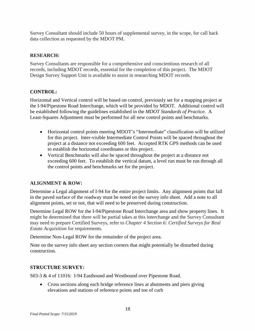
ATTACHMENT F CONSULTANT TRAFFIC CONTROL
CS 11016– JN 131843PE I-94 from St. Joseph River to Britain Avenue
The following traffic control must be implemented by the Consultant for survey, geotechnical data collection, and drainage video inspection.
Closure type Typical I-94 Lane Closure M0980a
I-94 Shoulder Closure M0880a
ON Ramp Road Work/Merge M044aMOD
Ramp Narrows w/ Shift M029bMOD
Non freeway Flag control M150a
Non freeway shoulder closure M110a
Work zone Tapers Table M0020a
Traffic Restrictions
1. Single lane closures can occur Monday - Thursday 7am to 3pm 2. Only one type of closure is allowed on any one bound of the
freeway at a time 3. only one type of closure is allowed on any one non-freeway at a
time
4. No devices will be left in place overnight at each location.
Prior to scheduling traffic control to be installed contact Gary Loyola, Coloma Business Office, Traffic, Safety & Operations Engineer at 269-849-2346 or [email protected] to discuss the traffic control work. Standard MDOT Traffic Control Typicals are available on the MDOT web site at: http://mdotcf.state.mi.us/public/tands/plans.cfm

28 Final Posted Scope: 7/15/2019
29 Final Posted Scope: 7/15/2019

30 Final Posted Scope: 7/15/2019
ATTACHMENT G LEVEL ONE DESIGN CRITERIA CHECKLIST
CS 11016 – JN 131843PE I-94 from St. Joseph River to Britain Avenue
Report conformance for existing and proposed conditions for the FHWA’S level one design criteria. Calculations supporting these checklists will be provided.
DESIGN CRITERIA The following example format or another similar format will be utilized to display the design criteria used to constrain the project scoping process. If additional design criteria are needed to fully convey the constraints of the design, they may be added to the table. Project Information Header: Route, Location Control Section, Job Number, AADT, Design Year.
Level One Design Criteria Checklist
Design Criteria (Provide numerical value for project, where indicated) Reference
Do the existing conditions meet MDOT criteria?
Existing Y/N Proposed 1. Design
Speed: Mainline: Ramps:
mph mph
RDM 3.06 Posted
70 mph Posted Y 75 mph Design
2. Lane Width Mainline: Ramps: Auxiliary lanes:
ft ft ft
Design Stand. Interstate S. AASHTO
12 feet
Y 12 Feet
3a. Uncurbed Sections – Shoulder Width adjacent to:
Design Stand. Interstate S. AASHTO
9 ft Outside 5 ft Inside 7 ft Outside TBD
N N Y
13 ft Outside 10 ft Inside 7 ft Outside 4 ft Inside
Mainline: 10’ Out Mainline: 10’ In Ramps: 7 ft Out Ramps: 4 ft In Auxiliary lanes:
ft ft ft

31 Final Posted Scope: 7/15/2019
3b. Curbed Sections – Curb Offset:
NA Y
Mainline: ft 4. Bridge Clear Roadway
Widths: 10 ft Outside 5 ft Inside
Design Stand. Interstate S. AASHTO
S13 Lake Street: 12’ Out 10’ In R04 Lost Dunes: 10’ Out 5.25’ In S16 Puetz Rd 10’ Out, 5.25’ In
Y Y Y
S13 Lake St: 12’ O 10’ In R04 L. Dunes: 10’ O 5.25’ In S16 Puetz Rd 10’ O 5.25’ In
5. Structural Capacity HS 20 Design Stand. Interstate S. AASHTO
S13 Lake Street: HS25 R04 Lost Dunes: HS20 S16 Puetz Rd: HS 20 + Mod
Y Y Y
No Change
6. Horizontal Curvature (minimum Radius) Rmin=2344 ft
Item 7 below For listing.
Sta 915+70 R=2292’
N
Check Radii for WB. File DE for 70mph R=2292’
7. Super Elevation Rate RDM 3.09.02 1. Straight L. 5.3% Straight L . 2.0% Straight L . 2.1% R-107 7%
Sta 576+20.65R R=2865’ e=5.5% Sta 757+21L R=11459’ e=2% Sta 875+70L R=7689’ e=2% Sta 915+70 R=2292’ e=5%
Y Y N N
R=2865’e=5% R=11459’e=2% R=7689’e=2.1% R=2292’E=6% File DE 70mph
8a. Stopping Sight Distance – Horizontal Curves
R=2000’ MDOT SSD
Rmin=2292’ Y All OK, Clear to 40’ min.
8b. Stopping Sight Distance – Vertical Curves
75 mph K=206 Sag K=312 Crest MDOT SSD GUIDE
561+79C K=313 576+00S K=364 592+00C K=750 630+00C K=2222 649+00S K=722 688+00C K=632 718+00S K=1411 776+00S K=6250 824+00S K=5555 863+00C K=7692 887+00S K=3225 914+80S K=400 936+26C K=379
Y Y Y Y Y Y Y Y Y Y Y Y Y
Retain Ex. Retain Ex. Retain Ex. Retain Ex. Retain Ex. Retain Ex. Retain Ex. Retain Ex. Retain Ex. Retain Ex. Retain Ex. Retain Ex. Retain Ex

32 Final Posted Scope: 7/15/2019
9. Maximum Long. Grades RDM 3.09.02
Retain Ex.
Sta 576+00, +1.81% Sta 936+00, -2.74
Y Y
Retain Ex Retain Ex
10. Through Travel Lane Cross Slope
RDM 3.09.02 1.5%-2%
1.5% Crown in Center
No 2% Crown on Outside Lane line
11. Vertical Clearances 16’ 0” S14 Livingston 16’ 10” R06 I&M 24’ 10” S15 John Beers 16’ 4”
Y Y Y
16’ 7” 24’ 7” 16’ 1”
12. Accessibility Criteria for Handicapped Individuals
NA No Sidewalk Ramps
13. Ramp Accel/Decl G. D. Guides
Exit 16 WB Off: Must be extended Exit 22 WB Off: Must be extended
N N
GEO-131 Compliant GEO-131 Compliant
14. Rollover NA NA NA NA