Embed Size (px)
Citation preview

M&E of Programs and the Data Infrastructure: GIS as the
Rosetta Stone
John SpencerMEASURE Evaluation

MEASURE Evaluation is funded by the U.S. Agency for
International Development (USAID) through Cooperative
Agreement GPO-A-00-03-00003-00 and is implemented by the
Carolina Population Center at the University of North Carolina
in partnership with Constella Futures International, John Snow,
Inc., ORC Macro International, and Tulane University.
Visit us online at http://www.cpc.unc.edu/measure.


Data

Where?

Why?


Value of Mapping Provides insight into
data
Provides a way to link different data
Strengthens data infrastructure by enforcing data schema standards
Picture worth 1,000 words

GIS

World in Layers

Value of Geography
Maps can be
Decision support tools
Analysis tools
Data display tools
More than just mapping

GEOGRAPHY CAN STRENGTHEN THE DATA INFRASTRUCTURE

Data Infrastructure
Available data
Systems to support, update and disseminate data

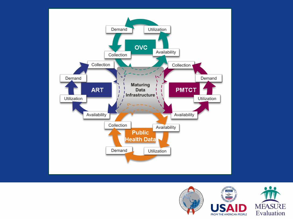

GIS as Rosetta Stone
GIS can be a “Rosetta Stone” to link different data sets
Produces maps showing linkages that may not have been made before
STRONGER DATA

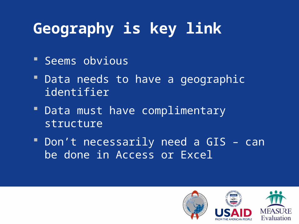
Geography is key link
PopulationDistrict Population
North 3253
South 5621
East 8732
West 7715
OVCDistrict Population
North 812
South 1011
East 2709
West 1411

Geography is key link
Population and OVCDistrict Population OVC
North 3253 812
South 5621 1011
East 8732 2709
West 7715 1411
Geography is key link
Seems obvious
Data needs to have a geographic identifier
Data must have complimentary structure
Don’t necessarily need a GIS – can be done in Access or Excel

Geographic Identifiers
-0.125140 S34.754213 E
-0.125312 S34.754180 E

Geographic Identifiers
Administrative units
Districts
Province
Ward
Etc.
Village or community name
OVC CASE STUDYNigeria


One Tool In the Toolbox

Key Steps Implementing GIS
Include Geographic Identifier in Data
Where are things?
Software
ArcGIS
Google Earth

Summary
Adding the “where” can help understand the “why”
Geography can act as a “Rosetta Stone” to link different elements of the data infrastructure
GIS/mapping can strengthen data quality by enforcing data schema standards

MAPPING FOR THE REST OF US
Excel and Google Earth

Mapping Challenges
Data
Must be well formed and have a geographic identifier
Software


Three shelves of ESRI Manuals and third party materials


Excel to Google Earth Macro
MEASURE Evaluation developed tool that allows Excel data to be mapped in Google Earth

Target Audience
Decision makers
Data and M&E staff
Anyone with Excel data they’d like to map

Not a GIS
Data display tool only
Doesn’t do spatial analysis
Buffering, density estimation, spatial stats, etc.
Can’t manage layers
Its niche is: a quick, easy to use tool

Advantages over a GIS
Permits quick mapping of data
Excel is widely used
Google Earth is free

Disadvantages of macro
Requires internet access
Google Earth lacks cartographic “niceties”
Data needs to be structured in the form that the macro expects
(Could be an advantage)

Plans
Available on request now
(Email [email protected])
“Early Beta”
Soliciting feedback and response
Improvements in Year 1 of Phase III

DEMO