Embed Size (px)
Citation preview

Measuring QoS and Mapping of Shared Infrastructure
Miodrag Ivković Electronic Communications
Department Director
Warsaw, 11÷12 April 2016.

Warsaw, 11÷12 April 2016.
QoS Parameters Submited by Operators
Telecommunications operators are required to submit the quality of service measuremet results at least once a year
RATEL keeps and publishes records on the quality of public communication networks and services on its website

We carry out QoS parameters measurements of:
Mobile and Fix services
BB services
Analog and Digital Media Content Distribution
Internet
IPTV
VoIP
Warsaw, 11÷12 April 2016.
Measuring QoS Submited by RATEL

RATEL NetTest QoS crowdsourcing platform
RATEL’s NetTest: platform for measuring the quality of internet connection for fixed and mobile users
NetTest follows the BEREC recommendation on internet coverage and quality
RATEL NetTest is in the final implementation phase
The platform enables quality measurement of all kinds of internet connections:
Mobile internet connection (EDGE, UMTE, LTE)
Fixed lines connection (DSL, LAN, fibre-optic)
WiFi connection
Warsaw, 11÷12 April 2016.
5 Warsaw, 11÷12 April 2016.
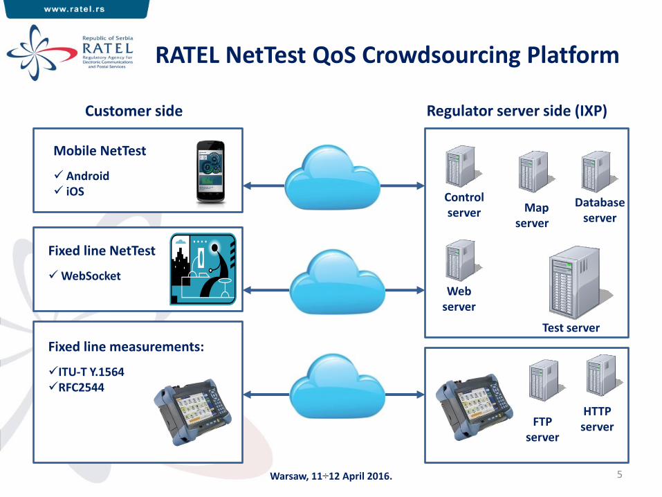
RATEL NetTest QoS Crowdsourcing Platform
Mobile NetTest
Android iOS
Fixed line NetTest
WebSocket
Regulator server side (IXP)
Control server Map
server
Database server
Web server
Test server
Customer side
Fixed line measurements:
ITU-T Y.1564 RFC2544
FTP server
HTTP server

6 Warsaw, 11÷12 April 2016.
RATEL NetTest QoS parameters
Mobile, WLAN: Signal strenght Up/Down throughput Jitter Ping Packet loss Traceroute VoIP test Unmodified content Web page test Connection
transparency DNS availability TCP/UDP ports avilability
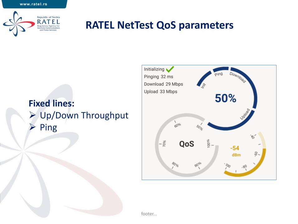
RATEL NetTest QoS parameters
footer...
Fixed lines: Up/Down Throughput Ping
8
Mobile Benchmarking tests (GSM, UMTS, LTE, LTE-A)
Mobile Voice Quality, ITU-T P.863 (POLQA)
RFC6349 TCP Throughput Testing
FTP testing (verification with measurement equipement)
HTTP testing (verification with measurement equipement)
Feasibility study on QoS DVB-T2 Monitoring Network
Operators quarterly reports on QoS network parameters
Future Plans
Warsaw, 11÷12 April 2016.
Infrastructure Mapping System
Detailed geo-referenced and structured information about the
telecommunication infrastructure in Serbia that may be
shared
Reasons for infrastructure mapping :
Optimization of infrastructure deployment
Avoiding costs of setting-up new networks
Better planning/cost sharing
Accelerating construction of Next Generation Networks
Warsaw, 11÷12 April 2016.
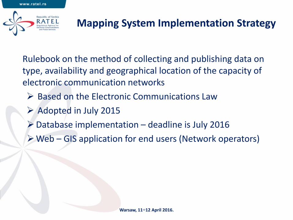
Mapping System Implementation Strategy
Rulebook on the method of collecting and publishing data on type, availability and geographical location of the capacity of electronic communication networks
Based on the Electronic Communications Law
Adopted in July 2015
Database implementation – deadline is July 2016
Web – GIS application for end users (Network operators)
Warsaw, 11÷12 April 2016.

Database (1)
RATEL is responsible for the database establishment, maintenance and financing
RATEL defines:
Data delivery method(s)
Database access procedures
Interfaces and protocols
Database will be operated by RATEL
Republic Geodetic Authority provides base for cable infrastructure data
Warsaw, 11÷12 April 2016.

Database (2)
What type of data is in the Database?
1) Cable infrastructure data:
Network operator (owner)/location/cable route
WGS84 coordinates of important nodes (beginning/end, junction)
Cable route length/geo-footage
Cable type
Conduits information (tube type / number of ducts in the tube / cabinet type / number of cabinets on the cable route)
Shared capacity / Unused capacity
Cable ending installation
Warsaw, 11÷12 April 2016.

Database (3)
2) Antenna towers and equipment:
Network operator (owner)
Antenna tower location
Tower construction type
Tower base shape/dimensions (m)
Tower height
Building height in meters (if the tower is mounted on a building)
Free tower space data (height of the free segment / available azimuth for mounting)
Equipment (type/free capacity) - if it is the subject of sharing
Warsaw, 11÷12 April 2016.
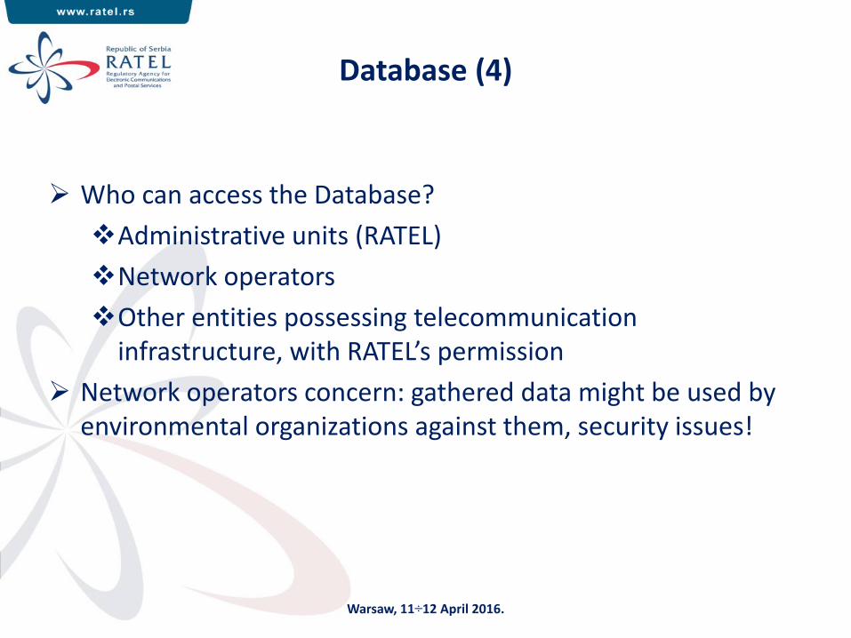
Database (4)
Who can access the Database?
Administrative units (RATEL)
Network operators
Other entities possessing telecommunication infrastructure, with RATEL’s permission
Network operators concern: gathered data might be used by environmental organizations against them, security issues!
Warsaw, 11÷12 April 2016.

Web Application (1)
Developed on Esri GIS mapping software solutions
Esri SDE (Spatial Database Engine)
Data can be imported:
Through a Web application
Via services for automated data exchange with Network operators
Defined access right control
Warsaw, 11÷12 April 2016.
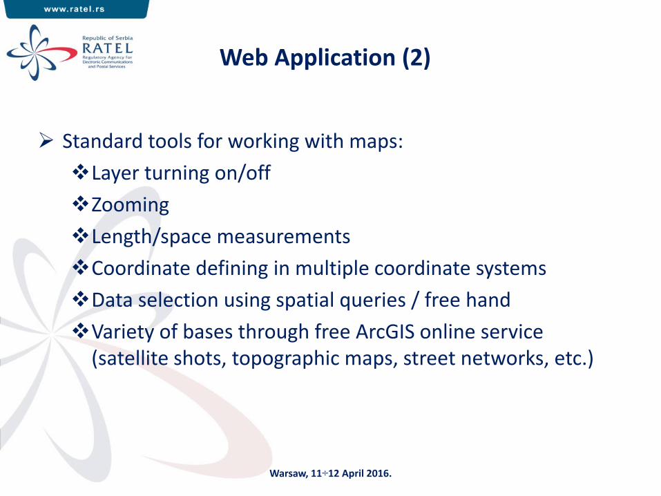
Web Application (2)
Standard tools for working with maps:
Layer turning on/off
Zooming
Length/space measurements
Coordinate defining in multiple coordinate systems
Data selection using spatial queries / free hand
Variety of bases through free ArcGIS online service (satellite shots, topographic maps, street networks, etc.)
Warsaw, 11÷12 April 2016.

Infrastructure Presentation
Warsaw, 11÷12 April 2016.

Different Map Views
Warsaw, 11÷12 April 2016.

Data Import into the Database
Warsaw, 11÷12 April 2016.

Using Standard Tools
Warsaw, 11÷12 April 2016.
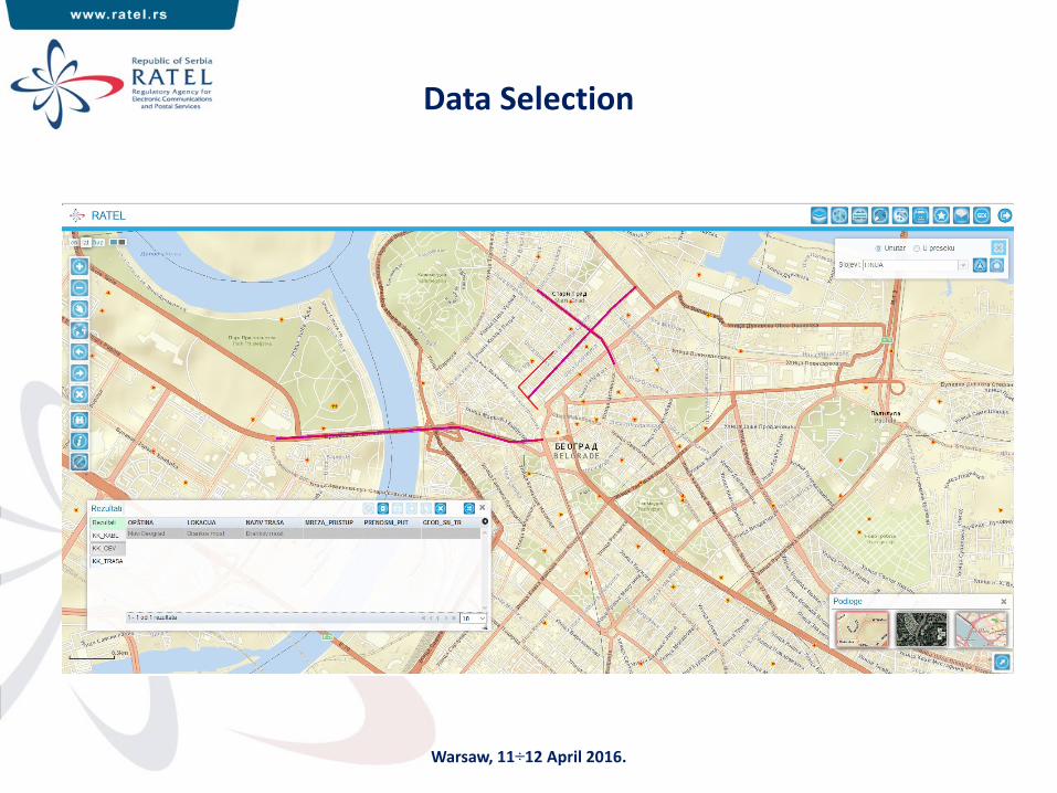
Data Selection
Warsaw, 11÷12 April 2016.
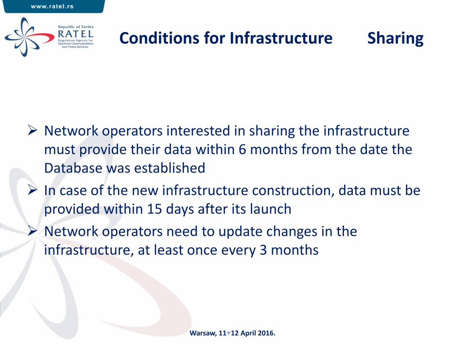
Conditions for Infrastructure Sharing
Network operators interested in sharing the infrastructure must provide their data within 6 months from the date the Database was established
In case of the new infrastructure construction, data must be provided within 15 days after its launch
Network operators need to update changes in the infrastructure, at least once every 3 months
Warsaw, 11÷12 April 2016.

23 Warsaw, 11÷12 April 2016.
Thank you for your attention

![A On QoS-Compliant Telehaptic Communication …arXiv:1805.10831v1 [cs.NI] 28 May 2018 A On QoS-Compliant Telehaptic Communication over Shared Networks Vineet Gokhale, Indian Institute](https://img.pdfslide.net/doc/110x75/5f5209dd345071620e4048df/a-on-qos-compliant-telehaptic-communication-arxiv180510831v1-csni-28-may-2018.jpg)


![X32-20060116-009R1 SBBC TX Stage-3 QoS Mapping [LU]](https://img.pdfslide.net/doc/110x75/577cc2bd1a28aba711947602/x32-20060116-009r1-sbbc-tx-stage-3-qos-mapping-lu.jpg)