Embed Size (px)
Citation preview
Page 2
accommodate the additional plot ratio) creates excessive building bulk in the locality and is not supported.
(3) The proposed 3.4 metre high boundary wall comprising of a 1.8 metre high brick wall (leading up from the basement) and the 1.6 metre high shrub (planter with hedge as privacy screening) on the South Eastern boundary is not considered to satisfy all of the amenity factors prescribed in Council Policy P350.2 “Residential boundary walls” , clause 5(a)(ii)(B) & (iii) and is therefore not supported.
(4) The applicant has not submitted a satisfactory waste management plan for the development.
(5) The applicant has not provided certification, to the satisfaction of the City, that the development achieves at least a four star rating under the relevant Green Star rating tool, or equivalent as per Council Policy P350.01 ‘Environmentally sustainable building design’.
(6) Having regard to the reasons identified above, the development conflicts with the objective (f) “safeguard and enhance the amenity of residential areas and ensure that new development is in harmony with the character and scale of existing residential development” listed under Clause 1.6(2) “Scheme Objectives” of TPS6.
(7) Having regard to the reasons identified above, the development conflicts with the following matters listed under Clause 6.7 “Matters to be Considered by Council” of DP for LPS:
(a) the aims and provisions of this Scheme and any other local planning scheme operating within the Scheme area;
(g) any local planning policy for the Scheme area; and (m) the compatibility of the development with its setting including the
relationship of the development to development on adjoining land or on other land in the locality including, but not limited to, the likely effect of the height, bulk, scale, orientation and appearance of the development.
Background: Insert Property Address: Lot 8 and 9 (No. 1 and 3) Gwenyfred Road,
Kensington Insert Zoning MRS: Urban TPS: Residential R80 Insert Use Class: Multiple Dwelling Insert Development Scheme: City of South Perth Town Planning Scheme No.
6 Insert Lot Size: 2 lots totalling - 1088m2 Insert Existing Land Use: Single dwelling on each lot Value of Development: $3 million The existing two dwellings on Lot 8 and 9 are of brick and tile construction that pre-dates 1950. Planning applications were previously considered by Council for Lot 9 No. 3 only. In April 2014, Council refused an application for five (5) multiple dwellings and one (1) grouped dwelling on this site. In December 2013, Council refused an application for seven (7) multiple dwellings on this site. An application for four (4)

Page 3
multiple dwellings was lodged in November 2012, however this was subsequently withdrawn by the applicant in February 2013. Details: outline of development application The amended planning application for reconsideration includes the following:
1. Reduced number of multiple dwellings from 17 to 14 dwellings (2 one bedroom dwellings (14%), 8 two bedroom dwellings (57%) and 4 two bedrooms plus loft dwellings (29%)) with a redesign/reconfiguration of level 2 to level 4 within the 4 storey building;
2. A change from the previous flat roof to a hip roof, containing loft rooms within the roof space (25 degree notational Pitch);
3. Basement level car parking with 31 car bays and 8 bike rack spaces; 4. Increased setbacks to the front, sides and rear boundaries; and 5. An increase to the amount of open space on site, including the communal
open space. Legislation & policy: Legislation Planning and Development Act 2005 Planning and Development Regulations 2015, Schedule 2, specifically Part 9 (Regulations) City of South Perth Town Planning Scheme No. 6, specifically Parts V, VI and VII; Tables 1 and 6; and Schedules 1 and 5. (TPS6) State Government Policies State Planning Policy 3.1 ‘Residential Design Codes’ (2015), specifically Part 6; and Tables 4 and 5. (R-Codes) Local Policies The following local planning policies are relevant to this application: Council Policy P301 ‘Consultation for Planning Proposals’ Council Policy P303 ‘Design Advisory Consultants’ Council Policy P350.01 ‘Environmentally Sustainable Building Design’ Council Policy P350.02 ‘Residential Boundary Walls’ Council Policy P350.03 ‘Car Parking Access, Siting, and Design’ Council Policy P350.05 ‘Trees on Development Sites and Street Verges’ Council Policy P350.07 ‘Fencing and Retaining Walls’ Further comment on compliance with the policy requirements is provided in the Planning assessment section of this report. Consultation: Public Consultation On the original proposal the City consulted with 41 neighbours, of which 17 submissions were received. During the reconsideration of the amended plans, the City notified the 17 submitters, giving them a week to review the news plan and provide comment.

Page 4
A total of 3 submissions were received, all of which were objections to the proposed development. The submissions were similar to the concerns raised in the original proposal and are contained in Attachment 5. Consultation with internal departments Comments were invited from City Environment, Engineering Infrastructure Services and Environmental Health Services of the City’s administration. City Environmental were generally satisfied with the amended drawings and have advised that the separation distance of the crossover between the street trees on either side is sufficient for the trees to be retained. Engineering Infrastructure Services were generally satisfied with the amended drawings, as they have addressed many of their concerns identified with the earlier proposal. They suggest relevant conditions be placed on the recommendation to the JDAP. The Environmental Health section was generally satisfied with the amended drawings and also suggests that relevant conditions be placed on the recommendation to the JDAP. Planning assessment: The following aspects have been assessed and found to be compliant with the provisions of TPS6, DP for LPS, the R-Codes and relevant Council policies, therefore have not been discussed further in the body of this report:
• Land use – “Multiple Dwelling” is a “P” (Permitted) land use on the subject site zoned “Residential” with a density coding of R80 (Table 1 of TPS6);
• Building height limit (TPS6 clause 6.1A); • Boundary Walls – NW side (Policy P350.2); • Lot boundary setbacks: Level 1(basement) and rear – south west (R-Codes
6.1.4); • Street surveillance (R-Codes clause 6.2.1); • Outdoor living areas (R-Codes clause 6.3.1); • Landscaping (R-Codes clause 6.3.2); • Minimum and maximum floor levels, site works and retaining walls (TPS6
clause 6.9 and 6.10; R-Codes clause 6.3.6 and 6.3.7); • Visual privacy (R-Codes clause 6.4.1); • Dwelling size (R-Codes clause 6.4.3);
The following planning matters that require further discussion are listed below:
• Plot ratio (R-Codes clause 6.1.1 & Table 4); • Lot boundary setbacks: sides – north west and south east (R-Codes 6.1.4); • Open space (R-Codes clause 6.1.5); • Solar access for adjoining sites (R-Codes clause 6.4.2); • Utilities and facilities (R-Codes clause 6.4.6); • Streetscape compatibility (Clause 67 (m) of the Deemed Provisions for local
planning schemes); • Council Policy P350.1 ‘Environmentally sustainable building design’; • Boundary Walls – SE side (Policy P350.2); and

Page 5
• Parking and vehicular access (R-Codes clauses 6.3.3, 6.3.4 and 6.3.5; TPS6 clause 6.3(8) and Schedule 9; Council Policy P350.03);
Plot ratio The maximum plot ratio for this site under Table 4 of the R-Codes is 1.0 (1088m2) and the proposed plot ratio for the development is 1.18 (1284m2). Therefore the proposed development does not comply with the plot ratio requirements of the R-Codes. The deemed-to-comply provisions under the R-Codes clause 6.1.1 (Building size), may be varied where it is considered that the design principals of clause P1 have been met, which states the following, “Development of the building is at a bulk and scale indicated in the local planning framework and is consistent with the existing or future desired built form of the locality.” The applicant provides the following justification in support of their proposed variation, as referred to in Attachments 3.
“The plot ratio has been reduced down from the 1.21:1 proposed under the previous application to 1.04:1 for the building excluding the loft space or 1:18:1 if the loft area is included. The loft space is not considered to contribute to the overall bulk and scale of the building, given it is designed to look no different to a standard pitched roof, and the roof will have very little (if any) visual impact as viewed from the street or any adjoining property. The overall bulk and scale of the building is therefore considered to be entirely consistent with a fully compliant building with a 1:1 plot ratio.
The proposed bulk and scale of the four storey building is considered appropriate for an R80 density coded lot, and future desired built form of the R80 lots to its west of the site. However, it is important to note that the street consists of R15 density coded lots immediately towards the east of the subject site (see diagram below).
Page 6
The existing building bulk of the lower R15 and R60 density lots consist single storey and two storey dwellings. Officers consider that the change from a flat roof to the proposed hip roof form, specifically to cater for the additional plot ratio (within the roof space) contributes significantly to the visual bulk of the amended proposal. It is noted that City’s Design Advisory Consultants (DAC) were supportive of the earlier flat roof proposal as it presented a lessor bulk and scale to that of a pitch roof in this locality. It is therefore considered that the additional plot ratio and change to the roof form of the development is at a bulk and scale that is not considered to be consistent with the existing or future desired built form of the locality and is therefore not supported by officers. Lot boundary setbacks (North West & South East sides) The deemed-to-comply provisions of the R-Codes clause 6.1.4 for lots with a 16 metre width or greater, prescribes a 4.0 metre setback to side boundaries. If the walls do not meet these minimum setbacks, the applicant is required to demonstrate that they meet with the relevant design principles (P4.1) of the Codes. The amended proposal comprises of portions along the building which do not meet with the minimum setback requirement. The applicant provides the following justification in support of their proposal:
“The design principals of the R-Codes (clause 6.1.4), state that buildings are to be setback from side and rear boundaries so as to: • Ensure adequate daylight, direct sun and ventilation for buildings and the
open space associated with them; • Moderate the visual impact of building bulk on a neighbouring property; • Ensure access to daylight and direct sun for adjoining properties; and • Assist with the protection of privacy between adjoining properties.
a. Along the south eastern side towards the front of the building, Levels 3 and
4 have been moved further away from the neighbouring property to further increase the stepping down to reflect the existing single storey streetscape on the southern side of Gwenyfred Road.
b. At the front of the building, the setbacks have been increased to all levels to allow for additional areas of landscaping in the front setback area, and reduce the visual impact of the building on the street. In the western corner of the building the proposed front setback is now essentially the same as that provided to the adjoining single residential building.
c. At the rear the dwellings have been reconfigured to remove one dwelling at each level, resulting in an increase in the setbacks to both the south eastern and south western sides of the building, ensuring that these portions of the building (with the exception of the lightweight stairs) now well exceed the 4.0m minimum setback requirements. Along the south eastern side, the setback is now 6.5m to the main building bulk, and over 5m to the screened walkway. The stairs are setback at 2.4m and represent a minor incursion into the 4.0m setback requirements, but with the increased setbacks to the rest of the building this represents far less of an
Page 7
impact than would be provided by a fully compliant building with a 4.0m setback along this side. The stairs themselves are clad in translucent glass rather than a solid building material to further reduce any bulk and scale impact.
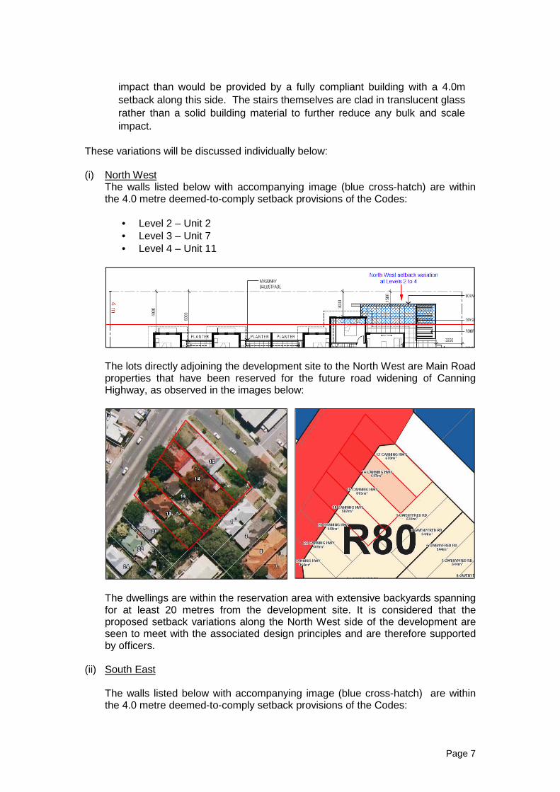
These variations will be discussed individually below: (i) North West
The walls listed below with accompanying image (blue cross-hatch) are within the 4.0 metre deemed-to-comply setback provisions of the Codes:
• Level 2 – Unit 2 • Level 3 – Unit 7 • Level 4 – Unit 11
The lots directly adjoining the development site to the North West are Main Road properties that have been reserved for the future road widening of Canning Highway, as observed in the images below:
The dwellings are within the reservation area with extensive backyards spanning for at least 20 metres from the development site. It is considered that the proposed setback variations along the North West side of the development are seen to meet with the associated design principles and are therefore supported by officers.
(ii) South East
The walls listed below with accompanying image (blue cross-hatch) are within the 4.0 metre deemed-to-comply setback provisions of the Codes:
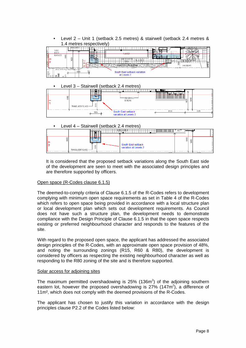
Page 8
• Level 2 – Unit 1 (setback 2.5 metres) & stairwell (setback 2.4 metres & 1.4 metres respectively)
• Level 3 – Stairwell (setback 2.4 metres)
• Level 4 – Stairwell (setback 2.4 metres)
It is considered that the proposed setback variations along the South East side of the development are seen to meet with the associated design principles and are therefore supported by officers.
Open space (R-Codes clause 6.1.5) The deemed-to-comply criteria of Clause 6.1.5 of the R-Codes refers to development complying with minimum open space requirements as set in Table 4 of the R-Codes which refers to open space being provided in accordance with a local structure plan or local development plan which sets out development requirements. As Council does not have such a structure plan, the development needs to demonstrate compliance with the Design Principle of Clause 6.1.5 in that the open space respects existing or preferred neighbourhood character and responds to the features of the site. With regard to the proposed open space, the applicant has addressed the associated design principles of the R-Codes, with an approximate open space provision of 48%, and noting the surrounding zonings (R15, R60 & R80), the development is considered by officers as respecting the existing neighbourhood character as well as responding to the R80 zoning of the site and is therefore supported. Solar access for adjoining sites The maximum permitted overshadowing is 25% (136m2) of the adjoining southern eastern lot, however the proposed overshadowing is 27% (147m2), a difference of 11m², which does not comply with the deemed provisions of the R-Codes. The applicant has chosen to justify this variation in accordance with the design principles clause P2.2 of the Codes listed below:
Page 9
“Development designed to protect solar access for neighbouring properties taking account the potential to overshadow existing: • outdoor living areas; • north facing major openings to habitable rooms, within 15 degrees of
north in each direction; or • roof mounted solar collectors.”
The applicant provides the following justification in support of their proposal:
“The amendments have resulted in a reduction to the amount of overshadowing on the neighbouring property, down from 30.7% down to 27% using a true north measurement. Even if the relevant design principle is applied, we note that the amount of additional overshadowing largely falls over the roof and the large shed in the "north western corner of the adjoining property, there are no north facing major openings within 15 degrees of north in each direction, or roof mounted solar collectors on the adjoining property. The development is therefore considered to comply with the design principles in addition to the deemed-to-comply requirements of the R-Codes.”
City officers consider the justification provided by the applicant adequately addresses the design principles of the R-Codes, in relation to proposed overshadowing and therefore supports the variation. Utilities and facilities The Deemed-to-Comply criteria of Clause 6.4.6 of the R-Codes requires that bins are not collected from the street immediately adjoining a dwelling, there shall be provision of a communal pick-up area or areas which are conveniently located for rubbish and recycling pick-up; accessible to residents; adequate in area to store all rubbish bins; and fully screened from the primary or secondary street. The City’s Health Services requires that in the development of a waste management plan, consideration is to be given to bulk rubbish bins (larger than the proposed 240L bins), ensuring that the bulk bins will fit through the opening to the bin-store area so that they can be presented for collection. Streetscape compatibility During the initial neighbour consultation period, a number of submitters raised concerns with regards to building bulk, scale, setbacks etc. of the proposed building, specifically indicating that these requirements would be out of character with the existing streetscape particularly on the southern side of Gwenyfred Road. The applicant offers the following justification in support of their amended plans:
“The flat roof has been replaced with a pitched roof to respond to the existing traditional streetscape of Gwenyfred Road and other new apartment development along Canning Highway. The roof is excluded from the measurement of building height and the development maintains a high level of compliance with the building height requirements of the City’s Scheme.” “As evidenced by the substantially different density codings of the subject site and the remainder of Gwenyfred Road, this site is clearly intended to be
Page 10
developed for a much more dense residential development than the reminder of the street, to provide an interface between future, higher density mixed use and commercial development along Canning Highway and the residential development beyond. In light of this context, it is considered that the development does achieve the general objectives of the above, in that it provides a transition to ensure the building fits in well with the existing streetscape. The key points regarding this proposal are as follows: • The nature of the streetscape is already mixed along Gwenyfred Road,
the site is located directly opposite a large scale commercial building which presents a substantially different front façade to the remaining residential development on this street. On this opposite side of the street there are also a mix of different residential developments including both two and single storey grouped and multiple dwelling developments on a variety of different lot sizes. The streetscape character of Gwenyfred Road is therefore considered to be mixed in nature.
• The development provides a transition from the 2m street setback which will be permitted for any future development on the site to the north west, and the greater front setback to the property to the south east, with a setback that increases from 3.3m to 6.3m along the length of the front boundary, being a greater setback than provided by the original application, and matching the setback of No. 5 Gwenyfred Road.
• The building provides a stepping down in height to the front, with the top storey setback 6.3 for the main building line so that it will have a reduced visual impact, when viewed from the street or footpath.
• The amended plans also increase the stepping down effect along the eastern corner of the building, the building now steps down from three storeys, to two, to one to match the neighbouring building.
• The pitched roof responds to the design of traditional houses along the southern side of Gwenyfred Road, while also reflecting new multiple dwelling development along Canning Highway.
• Soft landscaping including a tree is also proposed in this eastern corner of the site, sympathetic to the front gardens of the houses along Gwenyfred Road.
• The rendered façade with feature face brick panels also responds to the more traditional materials of the front facades of houses in this area.
In light of the above, it is considered that the development responds well to the streetscape context of Gwenyfred Road, whilst still proposing a development consistent with its very different density coding.”
Further to the applicant’s written justification, the amended plans are seen to achieve more consistency with the existing streetscape by way off increased setbacks along the front, sides and rear boundaries. In many aspects the proposed changes have achieved this to some extent, as evident in the comparisons between the previous plans and the current proposal, as indicated in the diagrams below:

Page 11
Diagram 1 – Level 1 (previously refused proposal)
Diagram 1a – Level 1 (current amended proposal)
Diagram 2 – Level 2 (previously refused proposal)
Diagram 2a – Level 2 (current amended proposal)

Page 12
Diagram 3 – Level 3 (previously refused proposal)
Diagram 3a – Level 2 (current amended proposal)
Diagram 4 – Level 4 (previously refused proposal)
Diagram 4a – Level 4 (current amended proposal)
Page 13
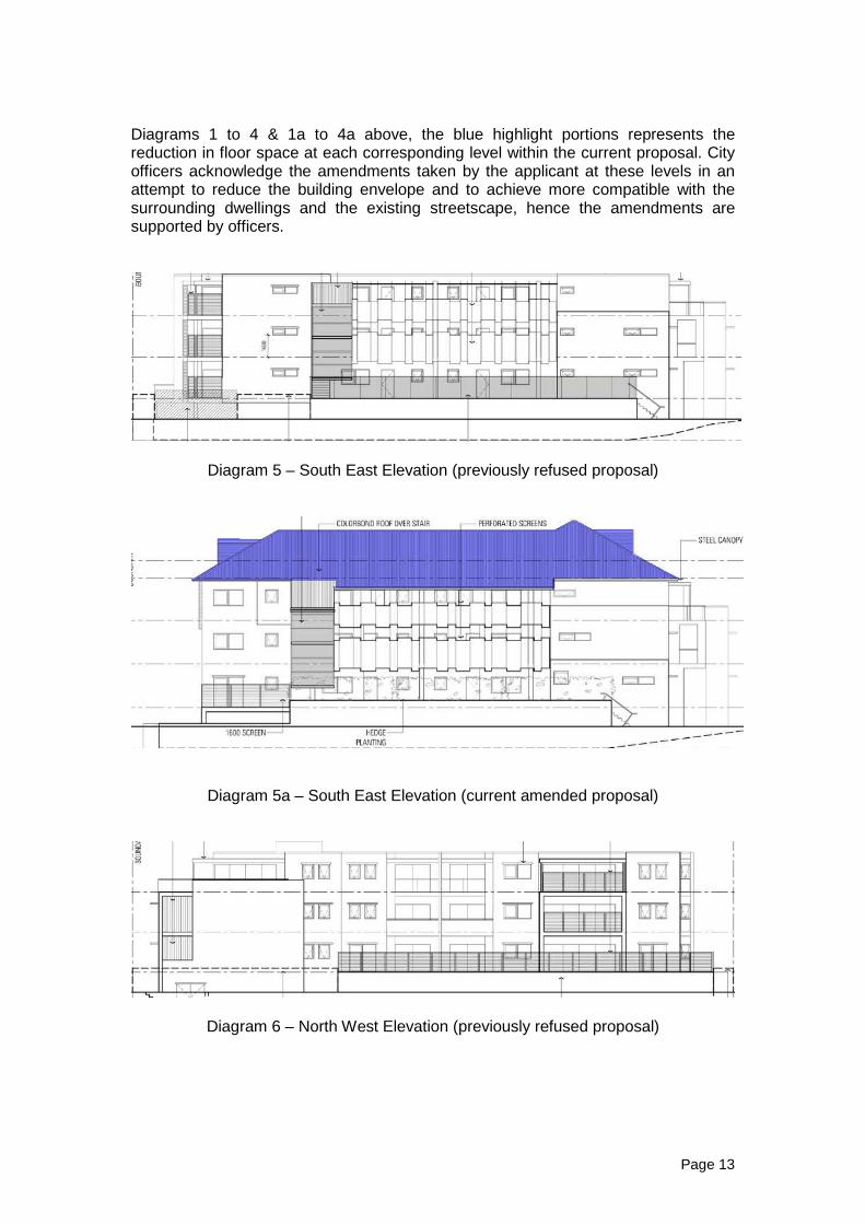
Diagrams 1 to 4 & 1a to 4a above, the blue highlight portions represents the reduction in floor space at each corresponding level within the current proposal. City officers acknowledge the amendments taken by the applicant at these levels in an attempt to reduce the building envelope and to achieve more compatible with the surrounding dwellings and the existing streetscape, hence the amendments are supported by officers.
Diagram 5 – South East Elevation (previously refused proposal)
Diagram 5a – South East Elevation (current amended proposal)
Diagram 6 – North West Elevation (previously refused proposal)
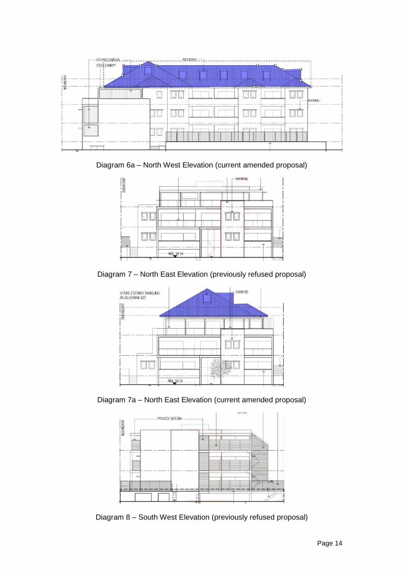
Page 14
Diagram 6a – North West Elevation (current amended proposal)
Diagram 7 – North East Elevation (previously refused proposal)
Diagram 7a – North East Elevation (current amended proposal)
Diagram 8 – South West Elevation (previously refused proposal)
Page 15
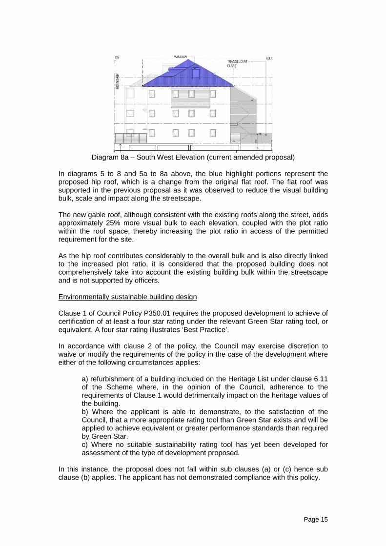
Diagram 8a – South West Elevation (current amended proposal)
In diagrams 5 to 8 and 5a to 8a above, the blue highlight portions represent the proposed hip roof, which is a change from the original flat roof. The flat roof was supported in the previous proposal as it was observed to reduce the visual building bulk, scale and impact along the streetscape. The new gable roof, although consistent with the existing roofs along the street, adds approximately 25% more visual bulk to each elevation, coupled with the plot ratio within the roof space, thereby increasing the plot ratio in access of the permitted requirement for the site. As the hip roof contributes considerably to the overall bulk and is also directly linked to the increased plot ratio, it is considered that the proposed building does not comprehensively take into account the existing building bulk within the streetscape and is not supported by officers. Environmentally sustainable building design Clause 1 of Council Policy P350.01 requires the proposed development to achieve of certification of at least a four star rating under the relevant Green Star rating tool, or equivalent. A four star rating illustrates ‘Best Practice’. In accordance with clause 2 of the policy, the Council may exercise discretion to waive or modify the requirements of the policy in the case of the development where either of the following circumstances applies:
a) refurbishment of a building included on the Heritage List under clause 6.11 of the Scheme where, in the opinion of the Council, adherence to the requirements of Clause 1 would detrimentally impact on the heritage values of the building. b) Where the applicant is able to demonstrate, to the satisfaction of the Council, that a more appropriate rating tool than Green Star exists and will be applied to achieve equivalent or greater performance standards than required by Green Star. c) Where no suitable sustainability rating tool has yet been developed for assessment of the type of development proposed.
In this instance, the proposal does not fall within sub clauses (a) or (c) hence sub clause (b) applies. The applicant has not demonstrated compliance with this policy.

Page 16
Boundary wall - South East Boundary walls are assessed having regard to the amenity provisions of Council Policy P350.2. City officers consider that the south eastern boundary wall would adversely affect the amenity of an adjoining property in relation to clause 5(a)(ii)(B) “outlook from any habitable room window of an adjoining dwelling” and 5(a)(iii) “visual impact of building bulk where the proposed boundary wall is situated alongside an outdoor living area on an adjoining lot”. The applicant provides the following comments in relation to the proposed boundary walls:
“The proposed development provides a 1.8m high wall along the south eastern boundary of the site, which is the same height as the existing dividing fence (refer to the attached section detail below). Above the fence we are proposing to plant a hedge, which will screen the views from the internal walkway into the adjoining property. It is important to note that the communal terrace which was previously proposed along this side of the building has been replaced by a series of landscaped beds, and the hedge now screens an internal walkway only, not an ‘outdoor active habitable space’, and could therefore simply be removed if the outcome is considered unacceptable by the City.
A ‘wall’ is defined in the R-Codes as: The vertical external face of a constructed building comprising solid building material and including enclosures to verandahs and balconies. The proposed hedge is not a solid building material and should therefore not be assessed as part of the ‘wall’ for the purposes of the City’s height calculations. In terms of the impact of the hedge, it is considered comparable to a row of small trees, or indeed a tall hedge being planted along a standard boundary fence and is not considered to have any undue impact on the adjoining property. This notwithstanding, even if the hedge was considered part of the wall, it is still considered that it would still comply with the City’s Residential Boundary Walls Policy 350.02, which states that boundary walls will not be approved where “…the City considers that such wall would adversely affect the

Page 17
amenity of an adjoining property or the streetscape in relation to the following amenity factors:
(i) streetscape character; (ii) outlook from:
(B) the front of an adjoining dwelling or its front garden, if the proposed boundary wall is located forward of that adjoining dwelling; or
(C) any habitable room window of an adjoining dwelling; (iii) visual impact of building bulk where the proposed boundary wall is
situated alongside an outdoor living area on an adjoining lot; and (iv) amount of overshadowing of a habitable room window, or an outdoor
living area, on an adjoining lot. The amenity impact of the boundary wall will be deemed to be acceptable where the portion of the proposed dwelling which conforms to the R-Codes Acceptable Development setback will overshadow this window or outdoor living area to an equivalent or greater extent than would the proposed boundary wall.”
The boundary wall and hedge is well setback over 11m from the street, behind the neighbour’s front porch and will therefore not have any adverse impact of the streetscape.
With respect to clause 5(a)(ii) above, it is reiterated that the boundary wall itself is located completely behind the existing boundary wall on No.5 Gwenyfred Road, so only the hedge itself will be visible from the adjoining property. In relation to point (a) of this subclause the boundary wall and hedge is substantial setback front the street as noted above, and is therefore not anticipated to have any adverse impact in terms of the outlook from the front of the property. The building itself is also stepped back along the front setback, well in excess of the minimum setback required by the R-Codes, so overall it is considered that the proposed development is very well designed to take into account the views out from this adjoining property. In relation to point (b) of clause 5(a)(ii), the adjoining properties do have habitable rooms along their north western boundary, and the hedge (but not the actual boundary wall below) will indeed be visible from these rooms. The Policy requires the decision maker to consider whether this would be an adverse impact. The impact of the hedge is considered very minimal, being of a similar impact to a standard line of vegetation planted along a fence. Indeed the adjoining property already has vegetation along its boundary to a similar height as seen in the attached ’street view’ image. The hedge does not result in any additional privacy, overlooking or overshadowing impact and in this case is considered to result in an improved amenity outcome for the adjoining property as it will assist by partially screening the three storey building proposed to be developed on the subject site. With respect to clause 5(a)(iii), the hedge and boundary wall finishes at essentially the same level as the neighbours backyard and patio, having a minimal impact on that area. The points raised above apply equally to this provision, i.e. that the minimal impact of the hedge is a positive one, by assisting with screening between the two properties.

Page 18
With respect to subclause 5(a)(iv), while the adjoining property does have a series of major openings along this side boundary, as illustrated in section AA and BB the overshadowing arises from the building itself, not the boundary wall. The building is setback at 5m at this point, greater than the minimum setback required by the R-Codes which would be 4m, and would clearly overshadow these windows and any outdoor living area at the rear to an equivalent or greater extent than the proposed hedge. It is reiterated that the actual boundary wall along the south eastern side of the proposed development is located below the level of a standard 1.8m high boundary fence, the only portion which sits above is the proposed hedge. Even if the proposed hedge was assessed as such, on this basis of the information above, we believed it would fully comply with the requirements of the City’s Policy. The layout of the adjoining dwelling has a number of major openings to habitable rooms which face the development site. These openings include a lounge, master bed, family room and a rear verandah/outdoor living area. The proposed boundary wall height is approximately 1.8 metres with a 1.6 metre high hedge screening for visual privacy located on top. Officers note that whilst the proposed 1.6 metre high screening allows light to partially pass through to the neighbouring dwelling, this structure will create shadow and add to the visual bulk adjacent to these habitable room windows and verandah/outdoor living area. The applicant providing a 1.6 – 1.8 metre high hedge for privacy screening at ground level would certainly be of lessor impact than that of a 1.8 metre high boundary, however placing privacy screening on top of a 1.8 metre high boundary wall (total height of 3.4 metres) for an approximate length of 24 metres (refer to Attachment 2) directly adjacent to these openings is not seen to meet the requirements nor the objectives of this policy. During consultation, concerns were raised regarding the impact of the boundary wall on the neighbour’s amenity. The proposed boundary wall is not seen to meet all of the amenity factors prescribed in Council Policy P305.2 and is not supported by officers. Parking and vehicular access The development is situated within location ‘A’ which is described under clause 6.3.3 of the R-Codes as being within 250m of a high frequency bus route. As such, the R-Codes require:
• Sixteen (15) occupier car bays and five (4) visitor car bays; and • Six (6) occupier bicycle parking spaces and two (2) visitor bicycle parking
spaces. The development proposes twenty seven (27) occupier car bays, four (4) designated visitor parking bays and ten (10) bicycle spaces. The proposal is seen to meets with this requirement and is supported by officers.

Page 19
Conclusion: Whilst aspects of this design are supported, the overall bulk of development is inconsistent with the future desired built form in this locality. This is based on a full assessment of the proposal and having regard to the relevant provisions of the City of South Perth Town Planning Scheme No.6, DP for LPS, R-Codes and relevant Council policies. Refusal is recommended.

Postal address: Locked Bag 2506 Perth WA 6001 Street address: 140 William Street Perth WA 6000 Tel: (08) 6551 9919 Fax: (08) 6551 9961 TTY: 6551 9007 Infoline: 1800 626 477
[email protected] www.planning.wa.gov.au ABN 35 482 341 493
LG Ref: 11.2015.310 DoP Ref: DAP/15/00844 Enquiries: Development Assessment Panels Telephone: (08) 6551 9919 Mr David Read TPG Town Planning, Urban Design & Heritage PO Box 7375 Cloisters Square WA 6850 Dear Mr Read Metro Central JDAP – City of South Perth – DAP Application 11.2015.310 Lot 8 and 9 (No. 1 and 3) Gwenyfred Road, Kensington 17 Multiple Dwellings within a Four-Storey Building Thank you for your application and plans submitted to the City of South Perth on 24 June 2015 for the above development at the abovementioned site. This application was considered by the Metro Central Joint Development Assessment Panel at its meeting held on 25 September 2015, where in accordance with the provisions of the City of South Perth Town of Planning Scheme No.6, it was resolved to refuse the application as per the attached notice of determination. Please be advised that there is a right of review by the State Administrative Tribunal in accordance with Part 14 of the Planning and Development Act 2005. Such an application must be made within 28 days of the determination in accordance with the State Administrative Tribunal Act 2004. Should you have any queries with respect to the reasons for refusal please contact Ms Trinh Nguyen at the City of South Perth on (08) 9474 0775. Yours sincerely Zoe Hendry DAP Secretariat 6/10/2015 Encl. DAP Determination Notice Cc: Ms Trinh Nguyen
City of South Perth
1
Planning and Development Act 2005
City of South Perth Town of Planning Scheme No.6
Metro Central Joint Development Assessment Panel
Determination on Development Assessment Panel
Application for Planning Approval
Location: Lot 8 and 9 (No. 1 and 3) Gwenyfred Road, Kensington Description of proposed Development: 17 Multiple Dwellings within a Four-Storey Building In accordance with regulation 8 of the Planning and Development (Development Assessment Panels) Regulations 2011, the above application for planning approval was refused on 25 September 2015, subject to the following: Refuse DAP Application reference DAP/15/00844 and accompanying plans P2014 (Survey – Proposed Building Outline: 20.08.15), P2014 Rev B (Level 1 Floor Plan: 25.08.15), P2014 Rev B (Level 2 Floor Plan: 25.08.15), P2014 Rev B (Level 3 Floor Plan: 25.08.15), P2014 Rev B (Level 4 Floor Plan: 25.08.15), P2014 Rev B (North East Elevation and South West Elevation: 25.08.15), P2014 Rev B (South East Elevation and North West Elevation: 25.08.15), P2014 Rev B (Elevations: 25.08.15), P2014 Rev A (Section AA and Section BB: 25.08.15), P2014 (Overshadow Diagram: 09.03.15), in accordance with Clause 7.9 of the City of South Perth Town Planning Scheme No. 6, for the following reasons:
Reasons
(1) The proposed development does not comply with either the deemed-to-comply
or design principles of Clause 6.1.1 “Building Size” of the Residential Design Codes of WA (R-Codes), specifically the provision of plot ratio at 1.23 in lieu of maximum prescribed plot ratio of 1.0.
(2) Having regard to Clause 7.5 subclauses (j) and (n) of TPS6 specifically the
general appearance of the building and the extent to which the proposed building is visually in harmony with the neighbouring buildings within the focus area, the current setbacks from the street alignment are not considered acceptable.
(3) The proposed development does not meet the deemed to comply or the
associated design principles of clause 6.4.2 “Solar access for adjoining sites” of the R-Codes. Specifically, the extent of shadow cast by the proposed building being 30.5 percent in lieu of 25 percent of the site area of the adjoining property and for not sufficiently protecting solar access for the neighbouring property.
(4) The proposed boundary wall (basement) on the South Eastern boundary is not
considered to satisfy the amenity factors prescribed in Council Policy P350.2 ‘Residential boundary walls) and is therefore not supported.