Embed Size (px)
Citation preview
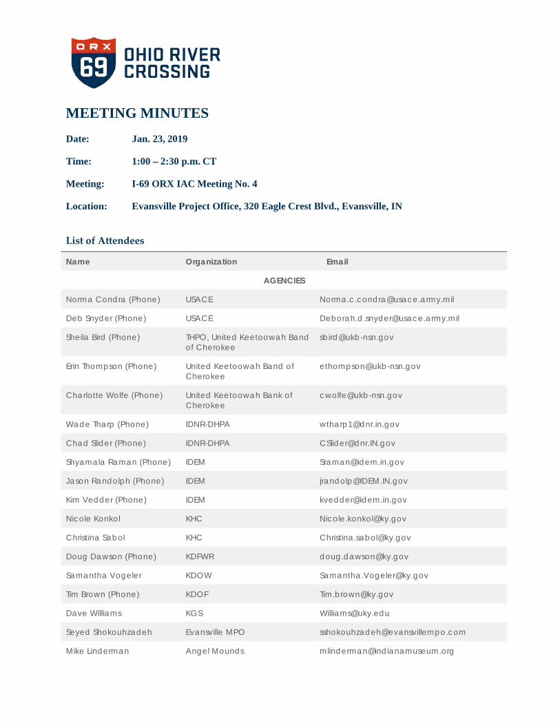
MEETING MINUTES
Date: Jan. 23, 2019
Time: 1:00 – 2:30 p.m. CT
Meeting: I-69 ORX IAC Meeting No. 4
Location: Evansville Project Office, 320 Eagle Crest Blvd., Evansville, IN
List of Attendees
Name Organization Email
AGENCIES
Norma Condra (Phone) USACE [email protected]
Deb Snyder (Phone) USACE [email protected]
Sheila Bird (Phone) THPO, United Keetoowah Band of Cherokee
Erin Thompson (Phone) United Keetoowah Band of Cherokee
Charlotte Wolfe (Phone) United Keetoowah Bank of Cherokee
Wade Tharp (Phone) IDNR-DHPA [email protected]
Chad Slider (Phone) IDNR-DHPA [email protected]
Shyamala Raman (Phone) IDEM [email protected]
Jason Randolph (Phone) IDEM [email protected]
Kim Vedder (Phone) IDEM [email protected]
Nicole Konkol KHC [email protected]
Christina Sabol KHC [email protected]
Doug Dawson (Phone) KDFWR [email protected]
Samantha Vogeler KDOW [email protected]
Tim Brown (Phone) KDOF [email protected]
Dave Williams KGS [email protected]
Seyed Shokouhzadeh Evansville MPO [email protected]
Mike Linderman Angel Mounds [email protected]

I-69 ORX IAC Meeting No. 4 Summary – Jan. 23, 2019
20190123 Meeting Minutes 2
Name Organization Email
PROJECT TEAM
Michelle Allen FHWA-IN [email protected]
Joiner Lagpacan (Phone) FHWA-IN [email protected]
Eric Rothermel FHWA-KY [email protected]
Laura Hilden INDOT [email protected]
Jim Poturalski INDOT [email protected]
Jonna Wallace Mabelitini KYTC-DEA [email protected]
Marshall Carrier KYTC [email protected]
Dan Davis KYTC-DEA [email protected]
Tim Foreman KYTC-DEA [email protected]
Gary Valentine KYTC [email protected]
Luke Eggering Parsons [email protected]
Cory Grayburn Parsons [email protected]
Diane Hoeting Parsons [email protected]
Dan Miller Parsons [email protected]
Steve Nicaise Parsons [email protected]
Juliet Port Parsons [email protected]
Dan Prevost Parsons [email protected]
Mindy Peterson C2 Strategic [email protected]
Cinder Miller Gray & Pape, Inc. [email protected]
Brian Aldridge Stantec [email protected]
ATTACHMENTS 1. IAC Meeting Agenda 2. IAC Meeting Presentation 3. Public Hearing Handout 4. DEIS Impact Summary Table 5. DEIS Appendix A-3
20190123 Meeting Minutes 3
I-69 ORX IAC Meeting No. 4 Summary – Jan. 23, 2019
SUMMARY
1) Welcome and Introductions – Dan Prevost, Parsons Environmental Lead for the I-69 Ohio River Crossing (ORX) project, opened the meeting and welcomed IAC participants.
• Housekeeping
• Introductions around room and on phone. Dan briefly ran through the agenda.
• Michelle Allen, FHWA, acknowledged the federal furlough and shared that the team decided to still hold this meeting. Federal agencies will still have their 45-day comment period for the DEIS.
2) IAC Meetings Recap • IAC Meeting No. 1 (Apr. 12, 2017) – Project purpose and need, range of
alternatives, and environmental methods and issues
• IAC Meeting No. 2 (Jul. 20, 2017) – Screening Report results
• Feb. 22, 2018 – Screening Report Supplement sent to IAC members
• IAC Meeting No. 3 (May 24, 2018) – Field tour of project area
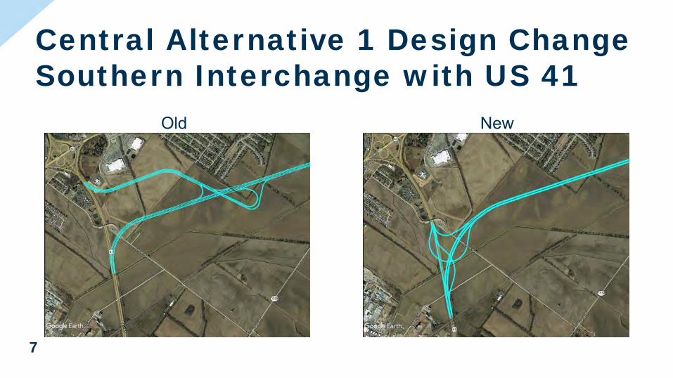
3) Design Changes Since Last IAC Meeting • Central Alternative 1 – Southern interchange with US 41 where the new
alignment ties back to US 41 in Kentucky. The team coordinated with the Henderson business community who expressed concern with the distance of the interchange from the business district. The redesigned interchange is located in the floodway of North Fork Canoe Creek and may require mitigation for loss of flood storage.
• Central Alternative 1 and West Alternative 1 Design Changes – The northbound US 41 bridge will be retained and the southbound US 41 bridge will be removed.
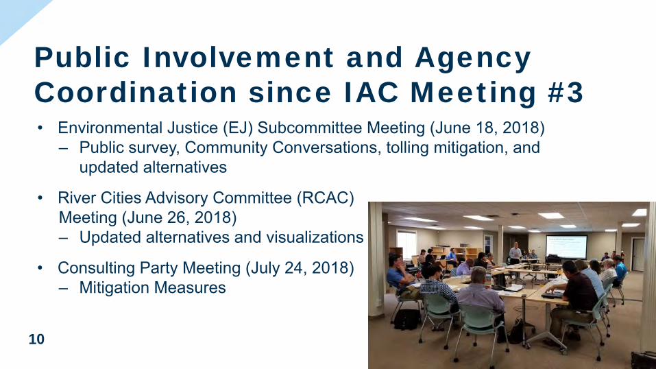
4) Public Involvement and Agency Coordination since IAC Meeting No. 3 • Environmental Justice (EJ) Subcommittee Meeting (Jun. 18, 2018) – Discussed
the public survey, Community Conversations, tolling mitigation, and updated alternatives.
• River Cities Advisory Committee (RCAC) Meeting (Jun. 26, 2018) – The project team shared the updated alternatives and project visualizations.
• Consulting Party Meeting (Jul. 24, 2018) – Discussed avoidance and mitigation measures for cultural resources.
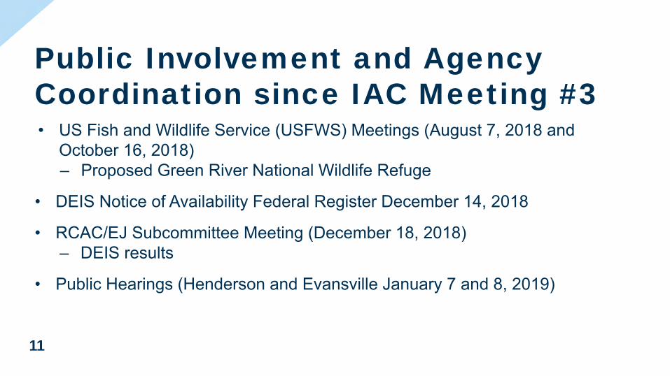
• U.S. Fish and Wildlife Service (USFWS) Meetings (Aug. 7, 2018 and Oct. 16, 2018) – Discussed the proposed Green River National Wildlife Refuge.
• DEIS Notice of Availability Federal Register (Dec. 14, 2018).
20190123 Meeting Minutes 4
I-69 ORX IAC Meeting No. 4 Summary – Jan. 23, 2019
• RCAC/EJ Subcommittee Meeting (Dec. 18, 2018) – Discussed the DEIS results.
• Public Hearings (Henderson and Evansville) Jan. 7 and 8, 2019.
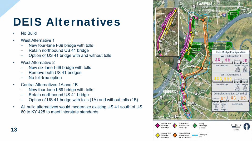
5) DEIS Alternatives • No Build
• West Alternative 1
• West Alternative 2
• Central Alternatives 1A and 1B (Preferred Alternatives – physically identical; only vary on tolling scenarios)
*All build alternatives would modernize existing US 41 south of US 60 to KY 425 to meet interstate standards.
6) Summary of Impacts • Dan shared impact summary/comparison tables for each environmental
category (e.g., relocations, Section 4(f)/6(f), farmland, noise, etc.).
• We are still in the process of completing archaeological surveys. Archaeological Survey Reports for Indiana and Kentucky will be provided upon completion.
7) Selection of Preferred Alternatives • Dan discussed the selection method for the Preferred Alternatives (Central
Alternatives 1A and 1B).
• A decision regarding US 41 tolling will be made prior to the FEIS/ROD. Toll revenue will vary depending on whether US 41 remains open and free and/or tolled.
• Tolling US 41 will be evaluated as part of the overall funding/financing plan for the project.
• The team will further develop the project’s Financial Plan over the next 6 months.
8) Review of Preferred Alternatives • Dan walked the group through the Preferred Alternative alignment on Google
Earth, showing select environmental features.
• The alignments are also shown on the handout (DEIS Appendix A-3).
9) Mitigation Measures and Commitments • Following avoidance and minimization, mitigation measures for streams and
wetlands will include wetland banks, in-lieu fee; flood storage mitigation; stream relocations; etc.
• Ecological commitments will include continued coordination with KDEP regarding water quality and aquatic habitat in the Ohio River; the use of the KY
20190123 Meeting Minutes 5
I-69 ORX IAC Meeting No. 4 Summary – Jan. 23, 2019
Programmatic Agreement for endangered bats; Stormwater Pollution Prevention Plan (SWPPP) development; and mussel surveys and Section 7 consultation with USFWS.
• EJ mitigation and commitments could include transponder purchase via cash; cash-loading of transponders; and reduced toll rates for low-income users, among other measures.
• The team will revisit farmland impacts and coordinate with NRCS as appropriate.
• Noise barrier design will be reevaluated for the Selected Alternative.
• The Section 106 Memorandum of Agreement (MOA) for cultural resources protection and mitigation will be finalized.
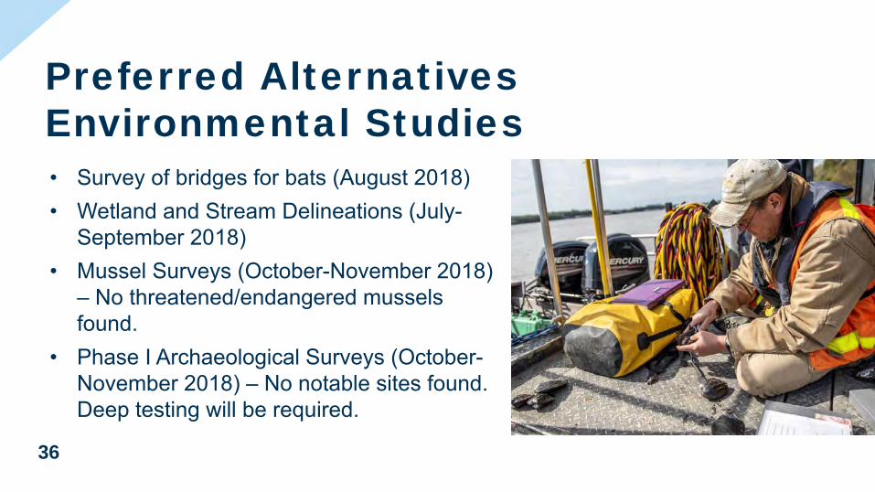
10) Preferred Alternatives Environmental Studies • Survey of bridges for bats (Aug. 2018)
• Wetland and stream delineations (Jul.-Sept. 2018)
• Mussel surveys (Oct.-Nov. 2018) (no threatened or endangered mussels found)
• Phase I Archaeological Survey (Oct.-Nov. 2018). Deep testing will also be performed in the Ohio River floodplain in 2019.
11) Next Steps • Winter 2019
DEIS Comments due Feb. 8, 2019
Biological Assessment
Phase 1 Archaeological Survey Report
• Spring 2019
Consulting Party Meeting No. 4
WOTUS Report and Jurisdictional Determination
• Summer 2019
Identification of final Preferred Alternative
IAC Meeting No. 5
• Fall 2019
FEIS/ROD Publication
12) Questions
Question: Samantha Vogeler, KDOW, asked if the team had identified a need for waste sites?
Response: Steve Nicaise, Parsons, responded that the project will require multiple
20190123 Meeting Minutes 6
I-69 ORX IAC Meeting No. 4 Summary – Jan. 23, 2019
borrow sites, but no waste sites.
Question: Samantha Vogeler, KDOW, asked what the team used as the basis for calculating impacts to WOTUS?
Response: Cory Grayburn, Parsons, responded that stream and wetland impacts were calculated within the construction limits.
Question: Jason Randolph, IDEM, asked whether the interchange area at the north end of the project would be built entirely on fill (i.e., require filling of the borrow pit and wetlands adjacent to Eagle Creek). He expressed a desire that the hydrology in the area be maintained.
Response: Steve Nicaise, Parsons, responded that the borrow pit and much of the adjacent wetlands would likely be bridged.
Question: Deb Snyder, USACE, asked whether we have an estimate of impacts to WOTUS, taking into account the areas that will be bridged (i.e., will an Individual Section 404 Permit be required)?
Response: Luke Eggering, Parsons, responded that an Individual Section 404 is anticipated for the project.
Question: Deb Snyder, USACE, asked if the team was aware of the proposed new WOTUS rule?
Response: The team affirmed they have knowledge of the proposed WOTUS rule. The ruling is not anticipated to affect how waters are permitted in Indiana since they are all connected to Eagle Creek.
Question: Kim Vedder, IDEM, asked if the team is planning on performing work on any of the landfills identified in Indiana?
Response: Juliet Port, Parsons, responded that the project will require limited excavation in Huff Landfill. Additional coordination with IDEM will be needed when the geotechnical studies are planned.
Question: Kim Vedder, IDEM, indicated that they have a visit/meeting scheduled for Huff Landfill on Feb. 7 and asked if Parsons would be available to attend the meeting with them?
Response: Juliet Port, Parsons, responded that Parsons could attend the meeting with IDEM.
20190123 Meeting Minutes 7
I-69 ORX IAC Meeting No. 4 Summary – Jan. 23, 2019
Question: Jason Randolph, IDEM, asked for confirmation of the proposed construction date of 2021, assuming funding is in place.
Response: Steve Nicaise, Parsons, responded “yes,” a 2021 construction start date would be a best-case scenario for start of construction.
Question: Samantha Vogeler, KDOW, requested that a copy of the Mussel Survey Report be sent to her. She also expressed interest in attending any onsite waters meetings with the USACE for Kentucky waters.
Response: Dan Prevost, Parsons, responded that a hard copy report will be sent to KDOW as requested.
13) Dan reminded everyone that the deadline for DEIS comments is Feb. 8. The meeting
adjourned at 2:30 p.m.
MEETING MINUTES
Date: February 12, 2019
Time: 10:00 – 12:00 p.m. CT
Meeting: I-69 ORX IAC Meeting No. 4 Session 2
Location: Parsons, 101 W. Ohio St., Suite 2121, Indianapolis IN, 46204
List of Attendees
Name Organization Email
AGENCIES
Norma Condra (Phone) USACE [email protected]
Deb Snyder (Phone) USACE [email protected]
Ntale Kajumba (Phone) US EPA [email protected]
Virginia Laszewski (Phone)
US EPA [email protected]
Duncan Powell (Phone) US EPA [email protected]
Ken Westlake (Phone) US EPA [email protected]
Michelle Allen FHWA [email protected]
Tina Chouinard (Phone) USFWS [email protected]
Phil DeGarmo (Phone) USFWS-KY [email protected]
Robin McWilliams-Munson (Phone)
USFWS [email protected]
Mike Linderman (Phone) Angel Mounds [email protected]
Seyed Shokouhzadeh (Phone)
Evansville MPO [email protected]
John Carr (Phone) IDNR [email protected]
Wade Tharp (Phone) IDNR-DHPA [email protected]
Diane Hunter (Phone) Miami Tribe [email protected]
I-69 ORX IAC Meeting No. 4 Supplemental – February 12th, 2019
20190212 Meeting Minutes 2
Name Organization Email
PROJECT TEAM
Andy Dietrick (Phone)
INDOT [email protected]
Laura Hilden INDOT [email protected]
Jim Poturalski INDOT [email protected]
Marshall Carrier (Phone)
KYTC [email protected]
Gary Valentine (Phone)
KYTC [email protected]
Luke Eggering (Phone)
Parsons [email protected]
Cory Grayburn (Phone)
Parsons [email protected]
Eric Jagger Parsons [email protected]
Dan Miller Parsons [email protected]
Steve Nicaise Parsons [email protected]
Juliet Port Parsons [email protected]
Dan Prevost Parsons [email protected]
Mindy Peterson (Phone)
C2 Strategic [email protected]
Erin Pipkin (Phone)
Compass Outreach Solutions
Cinder Miller (Phone)
Gray & Pape, Inc. [email protected]
Brian Aldridge (Phone)
Stantec [email protected]

20190212 Meeting Minutes 3
I-69 ORX IAC Meeting No. 4. Session 2 – Feb. 12th, 2019
SUMMARY Following Welcome and Introductions, Dan Prevost gave the same presentation from the I-69 ORX IAC Meeting No. 4 held January 23, 2019, which is summarized in previous meeting minutes.
1) Questions
Question: Ken Westlake, EPA, asked if the project alternatives provided for any pedestrian or bicycle use?
Response: Dan Prevost, Parsons, responded that the preferred alternatives do not include facilities for pedestrians or bicycles. The southbound bridge is proposed to be demolished. The existing local pedestrian/ bicycle plans do not include cross-river connections. Few public comments were received that requested this.
Question: Virginia Laszewski, USEPA, asked where the nearest pedestrian Ohio River crossing is located?
Response: The team responded that the current US 41 bridges can be used for bicycles but they must share the road with vehicles, so there is limited use. The closest crossing is the Owensboro bridge 30 miles away. It has a small (approximately 2-foot) raised curb on either side of bridge, so pedestrians and bicycles are permitted but it’s not designed for their use. The nearest crossing designed for safe pedestrian use is more than 100 miles away in the Louisville metropolitan area.
Question: Ntale Kajumba, USEPA, asked regarding the tolling options, what types of comments have been received from environmental justice stakeholders?
Response: Dan Prevost, Parsons, indicated that tolling has been a focus of the EJ outreach activities since the beginning of this NEPA process. There are many concerns about tolling, including from stakeholders representing low-income groups as well as businesses. The project team is looking at ways to mitigate tolling impacts if there is no local toll-free crossing.
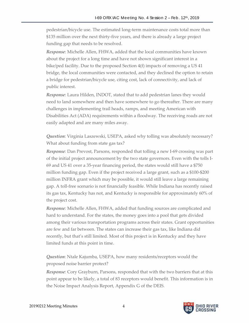
Question: Virginia Laszewski, USEPA, asked if a bicycle/pedestrian (bike/ped) path could be incorporated into the project? Is funding the only issue, wouldn’t it be inexpensive to add a bike/ped path or retain an existing bridge for that use? Response: Steve Nicaise, Parsons, responded that there is about 6 to 7 miles of alignment between potential between bike/ped connections in IN and KY. The main bridge is very long and the floodway is very wide, making it challenging for touch down points near the river. Response: Dan Prevost, Parsons, responded that we have inquired, but there is no local or state entity who is willing to maintain one of the US 41 bridges for
20190212 Meeting Minutes 4
I-69 ORX IAC Meeting No. 4 Session 2 – Feb. 12th, 2019
pedestrian/bicycle use. The estimated long-term maintenance costs total more than $135 million over the next thirty-five years, and there is already a large project funding gap that needs to be resolved.
Response: Michelle Allen, FHWA, added that the local communities have known about the project for a long time and have not shown significant interest in a bike/ped facility. Due to the proposed Section 4(f) impacts of removing a US 41 bridge, the local communities were contacted, and they declined the option to retain a bridge for pedestrian/bicycle use, citing cost, lack of connectivity, and lack of public interest.
Response: Laura Hilden, INDOT, stated that to add pedestrian lanes they would need to land somewhere and then have somewhere to go thereafter. There are many challenges in implementing trail heads, ramps, and meeting American with Disabilities Act (ADA) requirements within a floodway. The receiving roads are not easily adapted and are many miles away.
Question: Virginia Laszewski, USEPA, asked why tolling was absolutely necessary? What about funding from state gas tax?
Response: Dan Prevost, Parsons, responded that tolling a new I-69 crossing was part of the initial project announcement by the two state governors. Even with the tolls I-69 and US 41 over a 35-year financing period, the states would still have a $750 million funding gap. Even if the project received a large grant, such as a $100-$200 million INFRA grant which may be possible, it would still leave a large remaining gap. A toll-free scenario is not financially feasible. While Indiana has recently raised its gas tax, Kentucky has not, and Kentucky is responsible for approximately 60% of the project cost.
Response: Michelle Allen, FHWA, added that funding sources are complicated and hard to understand. For the states, the money goes into a pool that gets divided among their various transportation programs across their states. Grant opportunities are few and far between. The states can increase their gas tax, like Indiana did recently, but that’s still limited. Most of this project is in Kentucky and they have limited funds at this point in time.
Question: Ntale Kajumba, USEPA, how many residents/receptors would the proposed noise barrier protect?
Response: Cory Grayburn, Parsons, responded that with the two barriers that at this point appear to be likely, a total of 83 receptors would benefit. This information is in the Noise Impact Analysis Report, Appendix G of the DEIS.

20190212 Meeting Minutes 5
I-69 ORX IAC Meeting No. 4. Session 2 – Feb. 12th, 2019
Question: Ken Westlake, USEPA, asked why is there a dramatic difference in projected traffic between Alternatives 1a and 1b?
Response: Dan Prevost, Parsons, responded that that it was due the impact of tolling on regional traffic patterns and choice of bridge crossing.
Question: Virginia Laszewski, USEPA, asked if there an existing trail that a bridge could accommodate?
Response: Dan Prevost, Parsons, responded that there is a proposed Pigeon Creek Trail parallel to the river in Indiana, that would roughly follow Veterans Memorial Parkway along the levee, and eventually connect Evansville with Newburgh. Currently, the trail only exists west of the project area in the City of Evansville. There is an existing agreement with INDOT to permit a trail within the Veterans Memorial Parkway/I-69 right-of-way, with no specific location defined.
Question: Michael Johnson, USFWS, asked if the project team has considered connectivity for wildlife during flood events? Could there be issues for wildlife or public safety if terrestrial wildlife congregates on fill areas when seeking higher ground? US 41 is a good example of connectivity issues, such as deer coming up onto the roadway or into residential areas during flood events.
Response: The proposed bridges for I-69 across the Ohio River floodplain would be significantly longer than the existing US 41 bridges.
Question: Duncan Powell, USEPA, asked why are “outdated” mitigation ratios (based on acres of impact) being used? Do project costs reflect linear foot per stream?
Response: Deb Snyder, US Army Corps of Engineers, stated currently Indiana uses these ratios for their in-lieu fee programs.
Response: The project team stated that mitigation plans will be part of the permitting process, and specific ratios would be negotiated in each state based on actual impacts. A complete delineation and Waters of the US report is being performed for the preferred alternatives and we will evaluate mitigation in more detail as we move forward. Much of the stream impacts are for dry, ephemeral channels.
Question: Wade Tharp, IDNR-DHPA, asked if there are identified areas for deeper archaeological testing in Indiana?
Response: Dan Prevost, Parsons, stated that yes there are some areas proposed for deep testing in both Indiana and Kentucky. The Phase Ia archeological report is being prepared and will include a proposed deep testing plan.
20190212 Meeting Minutes 6
I-69 ORX IAC Meeting No. 4 Session 2 – Feb. 12th, 2019
Question: Robin McWilliams-Munson, USFWS, asked for an update on the bat survey.
Response: Dan Prevost, Parsons, stated this information is being compiled and will be submitted soon to USFWS as part of the Draft Biological Assessment.
Question: Ntale Kajumba, USEPA, asked what is the likelihood of this project moving forward?
Response: The project team stated that both states are dedicated to advancing this project and that they are still looking at their funding options.
Question: Virginia Laszewski, USEPA, asked when the funding package is expected?
Response: Gary Valentine, KYTC, stated that a final funding plan is not required for the FEIS/ROD, but that the metropolitan planning organization’s (MPO’s) fiscally constrained long range plan must be updated prior to the Record of Decision (ROD).
Response: Seyed Shokouhzadeh, Evansville MPO, added that the proposed TIP is out for comment, and page 62 discusses these projects.
Question: Norma Condra, US Army Corps of Engineers, asked what is the status of the proposed Green River Wildlife Refuge?
Response: Tina Chouinard, USFWS, stated that it is still in the scoping phase. There is a draft EA that is coming out shortly for public review, and will have a 30-day review period. There are hopes to finalize the plan in the summer of 2019. They are closely coordinating with this project.
Question: Norma Condra, US Army Corps of Engineers, asked if the proposed Green River Wildlife Refuge would be used for mitigation?
Response: Dan Prevost, Parsons, stated that the team has been discussing mitigation options with USFWS. Once we have a selected corridor and know more specifics about our mitigation requirements there will be further coordination. USFWS’s EA will exclude this project corridor.
Question: Virginia Laszewski, USEPA, asked what will happen if there is another government shutdown?
Response: Dan Prevost, Parsons, stated that if that happens we would discuss that when the agencies return to work.
20190212 Meeting Minutes 7
I-69 ORX IAC Meeting No. 4. Session 2 – Feb. 12th, 2019
2) Dan reminded everyone that the DEIS comment period for Federal agencies affected by the
partial US government shutdown has been extended from February 8th to March 18th. The meeting adjourned at 12:00 p.m.
MEETING AGENDA
Date: January 23, 2019
Time: 1:00 PM CT – 3:00 PM CT
Meeting: I-69 ORX Interagency Advisory Committee Meeting #4
Location: I-69 ORX Evansville Project Office 320 Eagle Crest Drive, Suite C, Evansville,IN 47708
1. Introductions
2. Recap of Previous IAC Meetings
3. Design Changes Since Last IAC Meeting
4. Public Involvement and Agency Coordination
5. DEIS Alternatives
6. Summary of Impacts
7. Selection of Preferred Alternatives
8. Review of Preferred Alternatives
9. Mitigation Measures and Commitments
10. Preferred Alternative Environmental Studies
11. Next Steps
12. Questions
Attachment 1
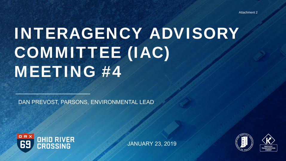
INTERAGENCY ADVISORY COMMITTEE (IAC) MEETING #4
DAN PREVOST, PARSONS, ENVIRONMENTAL LEAD
JANUARY 23, 2019
Attachment 2
2
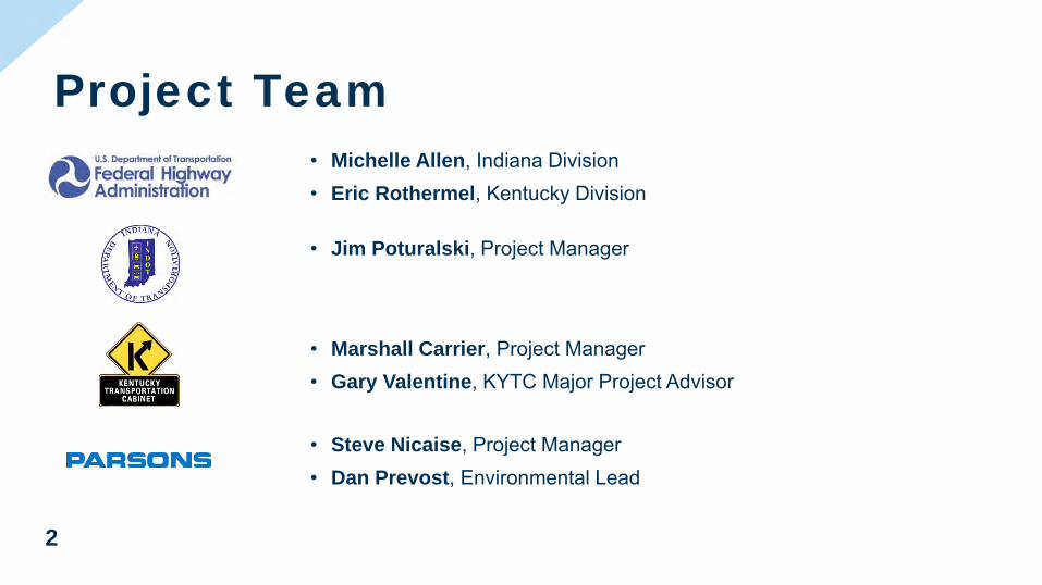
• Michelle Allen, Indiana Division• Eric Rothermel, Kentucky Division
Project Team
• Jim Poturalski, Project Manager
• Marshall Carrier, Project Manager• Gary Valentine, KYTC Major Project Advisor
• Steve Nicaise, Project Manager• Dan Prevost, Environmental Lead
Attachment 2
3
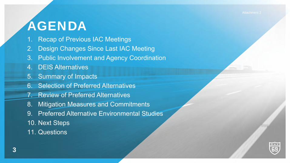
AGENDA1. Recap of Previous IAC Meetings 2. Design Changes Since Last IAC Meeting3. Public Involvement and Agency Coordination4. DEIS Alternatives5. Summary of Impacts6. Selection of Preferred Alternatives7. Review of Preferred Alternatives8. Mitigation Measures and Commitments9. Preferred Alternative Environmental Studies10. Next Steps11. Questions
Attachment 2

4
RECAP OF PREVIOUS IAC MEETINGS
Attachment 2
5
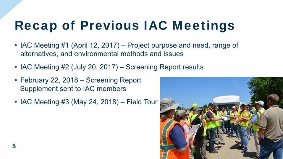
• IAC Meeting #1 (April 12, 2017) – Project purpose and need, range of alternatives, and environmental methods and issues
• IAC Meeting #2 (July 20, 2017) – Screening Report results
• February 22, 2018 – Screening Report Supplement sent to IAC members
• IAC Meeting #3 (May 24, 2018) – Field Tour
Recap of Previous IAC MeetingsAttachment 2
6
DESIGN CHANGES SINCE LAST IACMEETING
Attachment 2
7
Central Alternative 1 Design ChangeSouthern Interchange with US 41
Old New
Attachment 2
8
• Retain northbound US 41 bridge and remove southbound US 41 bridge‒ Both bridges are eligible for NRHP
‒ Northbound – eligible individually‒ Southbound – only eligible based on being a “twin” to
northbound bridge‒ Kentucky SHPO recommended retaining northbound bridge‒ Remove southbound bridge: northbound remains eligible‒ Remove northbound bridge: northbound (demolished) and southbound
would lose eligibility
Central Alternative 1 and West Alternative 1 Design Changes
Attachment 2
9
PUBLIC INVOLVEMENT AND AGENCY COORDINATION
Attachment 2
10
• Environmental Justice (EJ) Subcommittee Meeting (June 18, 2018)‒ Public survey, Community Conversations, tolling mitigation, and
updated alternatives
• River Cities Advisory Committee (RCAC) Meeting (June 26, 2018)‒ Updated alternatives and visualizations
• Consulting Party Meeting (July 24, 2018)‒ Mitigation Measures
Public Involvement and Agency Coordination since IAC Meeting #3
Attachment 2
11
• US Fish and Wildlife Service (USFWS) Meetings (August 7, 2018 and October 16, 2018)‒ Proposed Green River National Wildlife Refuge
• DEIS Notice of Availability Federal Register December 14, 2018
• RCAC/EJ Subcommittee Meeting (December 18, 2018)‒ DEIS results
• Public Hearings (Henderson and Evansville January 7 and 8, 2019)
Public Involvement and Agency Coordination since IAC Meeting #3
Attachment 2
12
DEIS ALTERNATIVES
Attachment 2
13
• No Build
• West Alternative 1‒ New four-lane I-69 bridge with tolls‒ Retain northbound US 41 bridge‒ Option of US 41 bridge with and without tolls
• West Alternative 2‒ New six-lane I-69 bridge with tolls‒ Remove both US 41 bridges‒ No toll-free option
• Central Alternatives 1A and 1B‒ New four-lane I-69 bridge with tolls‒ Retain northbound US 41 bridge‒ Option of US 41 bridge with tolls (1A) and without tolls (1B)
• All build alternatives would modernize existing US 41 south of US 60 to KY 425 to meet interstate standards
DEIS AlternativesAttachment 2
14
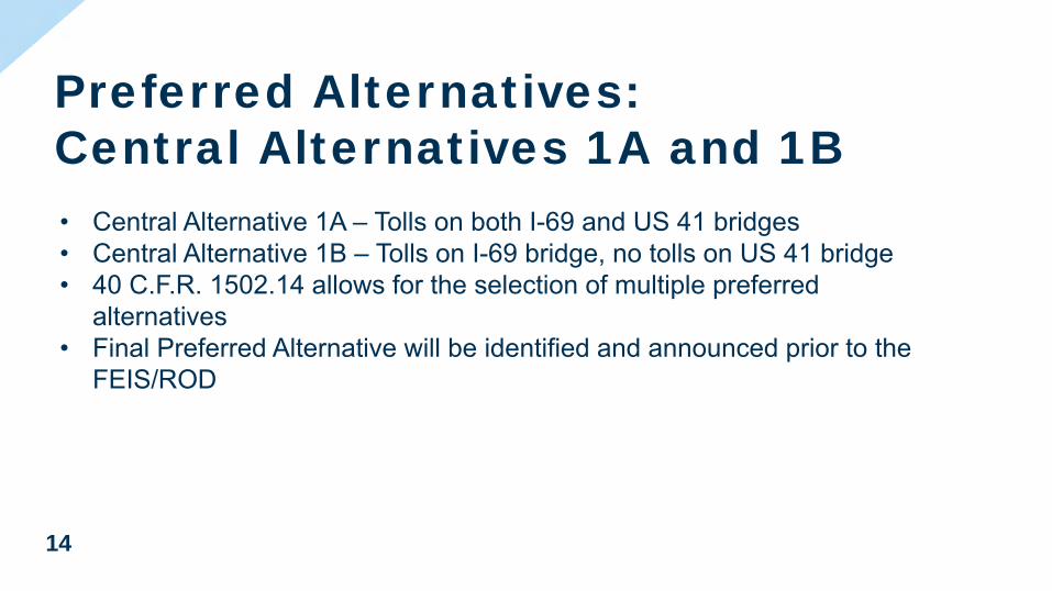
• Central Alternative 1A – Tolls on both I-69 and US 41 bridges• Central Alternative 1B – Tolls on I-69 bridge, no tolls on US 41 bridge• 40 C.F.R. 1502.14 allows for the selection of multiple preferred
alternatives• Final Preferred Alternative will be identified and announced prior to the
FEIS/ROD
Preferred Alternatives: Central Alternatives 1A and 1B
Attachment 2
15
SUMMARY OF IMPACTS
Attachment 2
16
Impact Summary – Relocations/ROW
IMPACT CATEGORY WEST ALTERNATIVE 1
WEST ALTERNATIVE 2
CENTRAL ALTERNATIVES
1A AND 1B(PREFERRED)
Relocations Residential (units) 242 96 4Commercial (units) 25 62 0Farm Building 1 1 0Places of Worship 1 1 0Total Relocations 269 160 4
New Right-of-way (acres) 333 298 420
Attachment 2
17
Impact Summary – Sec 4(f) / Sec 106
IMPACT CATEGORY WEST ALTERNATIVE 1
WEST ALTERNATIVE 2
CENTRAL ALTERNATIVES
1A AND 1B(PREFERRED)
Section 4(f) UsePublic Parks, Recreation Areas, and Wildlife/ Waterfowl Refuges
1 1 0
Historic Property 1 2 1Aboveground Historic Resources 2 2 4
Attachment 2
18
Impact Summary – REC / Farmland
IMPACT CATEGORY WEST ALTERNATIVE 1
WEST ALTERNATIVE 2
CENTRAL ALTERNATIVES
1A AND 1B(PREFERRED)
Recognized Environmental Condition (REC) Sites
13 21 4
Prime and Unique Farmland and Farmland of Statewide Importance (acres)
84.9 46.2 382.7
Active Farmland (acres) 182.6 168.9 347.9
Attachment 2
19
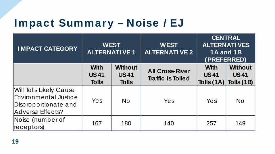
Impact Summary – Noise / EJ
IMPACT CATEGORY WEST ALTERNATIVE 1
WEST ALTERNATIVE 2
CENTRAL ALTERNATIVES
1A and 1B(PREFERRED)
With US 41 Tolls
Without US 41 Tolls
All Cross-River Traffic is Tolled
WithUS 41
Tolls (1A)
Without US 41
Tolls (1B)Will Tolls Likely Cause Environmental Justice Disproportionate and Adverse Effects?
Yes No Yes Yes No
Noise (number of receptors) 167 180 140 257 149
Attachment 2
20
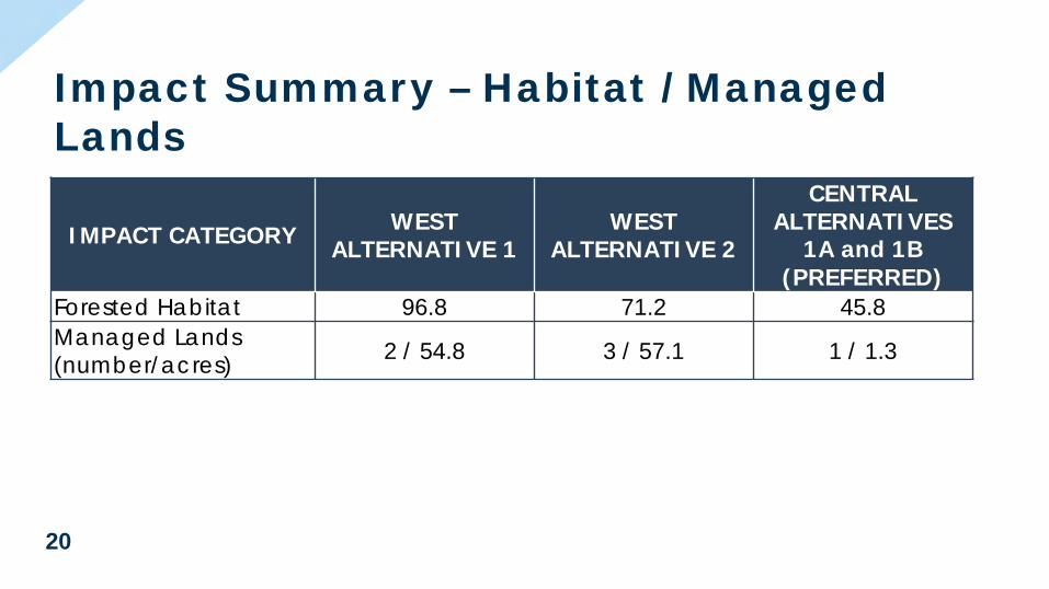
Impact Summary – Habitat / Managed Lands
IMPACT CATEGORY WEST ALTERNATIVE 1
WEST ALTERNATIVE 2
CENTRAL ALTERNATIVES
1A and 1B(PREFERRED)
Forested Habitat 96.8 71.2 45.8Managed Lands (number/acres) 2 / 54.8 3 / 57.1 1 / 1.3
Attachment 2

21
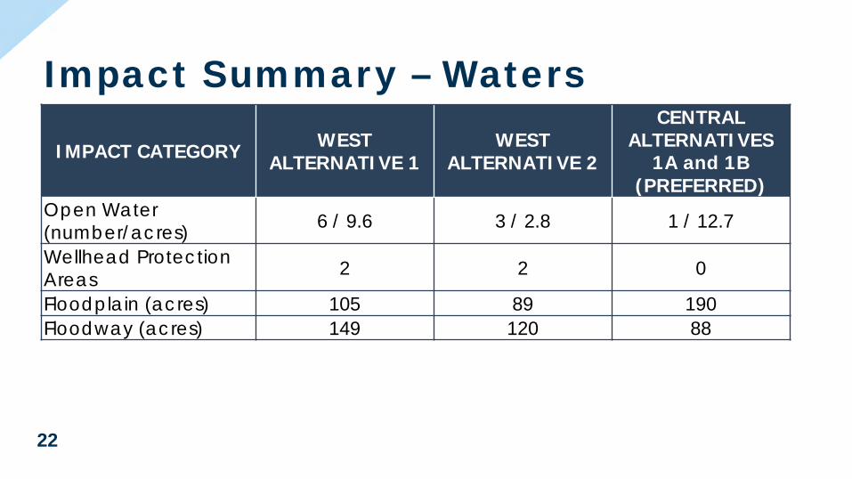
Impact Summary – Waters
IMPACT CATEGORY WEST ALTERNATIVE 1
WEST ALTERNATIVE 2
CENTRAL ALTERNATIVES
1A and 1B(PREFERRED)
Wetlands (number/acres) 18 / 55.4 17 / 35.1 7 / 17.6
Streams (number/linear feet)
Perennial 5 / 1,799 5 / 1,556 3 / 1,608Intermittent 3 / 790 2 / 511 1 / 683Ephemeral 39 / 20,886 37 / 19,085 49 / 16,036Total 47 / 23,475 44 / 21,152 53 / 18,327
Attachment 2
22
Impact Summary – Waters
IMPACT CATEGORY WEST ALTERNATIVE 1
WEST ALTERNATIVE 2
CENTRAL ALTERNATIVES
1A and 1B(PREFERRED)
Open Water (number/acres) 6 / 9.6 3 / 2.8 1 / 12.7
Wellhead Protection Areas 2 2 0
Floodplain (acres) 105 89 190Floodway (acres) 149 120 88
Attachment 2
23
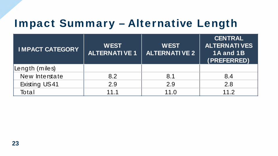
Impact Summary – Alternative Length
IMPACT CATEGORY WEST ALTERNATIVE 1
WEST ALTERNATIVE 2
CENTRAL ALTERNATIVES
1A and 1B(PREFERRED)
Length (miles)New Interstate 8.2 8.1 8.4Existing US 41 2.9 2.9 2.8Total 11.1 11.0 11.2
Attachment 2
24
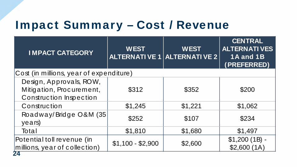
Impact Summary – Cost / Revenue
IMPACT CATEGORY WEST ALTERNATIVE 1
WEST ALTERNATIVE 2
CENTRAL ALTERNATIVES
1A and 1B(PREFERRED)
Cost (in millions, year of expenditure)Design, Approvals, ROW, Mitigation, Procurement, Construction Inspection
$312 $352 $200
Construction $1,245 $1,221 $1,062Roadway/Bridge O&M (35 years) $252 $107 $234
Total $1,810 $1,680 $1,497Potential toll revenue (in millions, year of collection) $1,100 - $2,900 $2,600 $1,200 (1B) -
$2,600 (1A)
Attachment 2
25
SELECTION OF PREFERRED ALTERNATIVES
Attachment 2
26
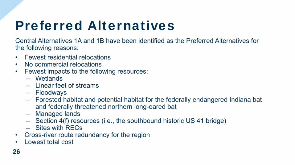
Central Alternatives 1A and 1B have been identified as the Preferred Alternatives for the following reasons:• Fewest residential relocations• No commercial relocations• Fewest impacts to the following resources:
‒ Wetlands‒ Linear feet of streams‒ Floodways‒ Forested habitat and potential habitat for the federally endangered Indiana bat
and federally threatened northern long-eared bat‒ Managed lands‒ Section 4(f) resources (i.e., the southbound historic US 41 bridge)‒ Sites with RECs
• Cross-river route redundancy for the region• Lowest total cost
Preferred AlternativesAttachment 2

27
Tolls on US 41• No decision has been made – Decision to be made prior to FEIS/ROD
• Will be evaluated as part of overall funding/financing plan
Attachment 2
28
REVIEW OF PREFERRED ALTERNATIVES
Attachment 2
29
MITIGATION MEASURES AND COMMITMENTS
Attachment 2

30
• Continued efforts during design to avoid and minimize stream and wetland impacts.
• Stream mitigation may include mitigation banks, in-lieu fee programs, and stream relocations.
• Wetland mitigation may include mitigation banks, in-lieu fee programs, and permittee responsible mitigation. Impacted wetlands will be replaced at the appropriate mitigation ratios based on USACE guidelines.
Mitigation and Commitments –Waters of the U.S.
Attachment 2

31
• Continue coordination with KDEP regarding water quality and aquatic habitat in the Ohio River (Outstanding Surface Water Resource).
• Stormwater Pollution Prevention Plan (SWPPP) and Best Management Practices (BMPs).
• In Indiana, trees removed within a non-wetland forested floodway/floodplain will be replaced in accordance with IDNR’s Construction in a Floodway Permit guidelines.
• Complete mussel surveys and Section 7 consultation with USFWS.• The KYTC Programmatic Conservation Memorandum of Agreement for the Indiana
Bat will be used to determine mitigation requirements for the Indiana bat and the northern long-eared bat.
Mitigation Measures and Commitments – Ecology
Attachment 2
32
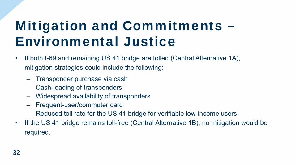
• If both I-69 and remaining US 41 bridge are tolled (Central Alternative 1A), mitigation strategies could include the following:
‒ Transponder purchase via cash‒ Cash-loading of transponders‒ Widespread availability of transponders‒ Frequent-user/commuter card‒ Reduced toll rate for the US 41 bridge for verifiable low-income users.
• If the US 41 bridge remains toll-free (Central Alternative 1B), no mitigation would be required.
Mitigation and Commitments –Environmental Justice
Attachment 2
33
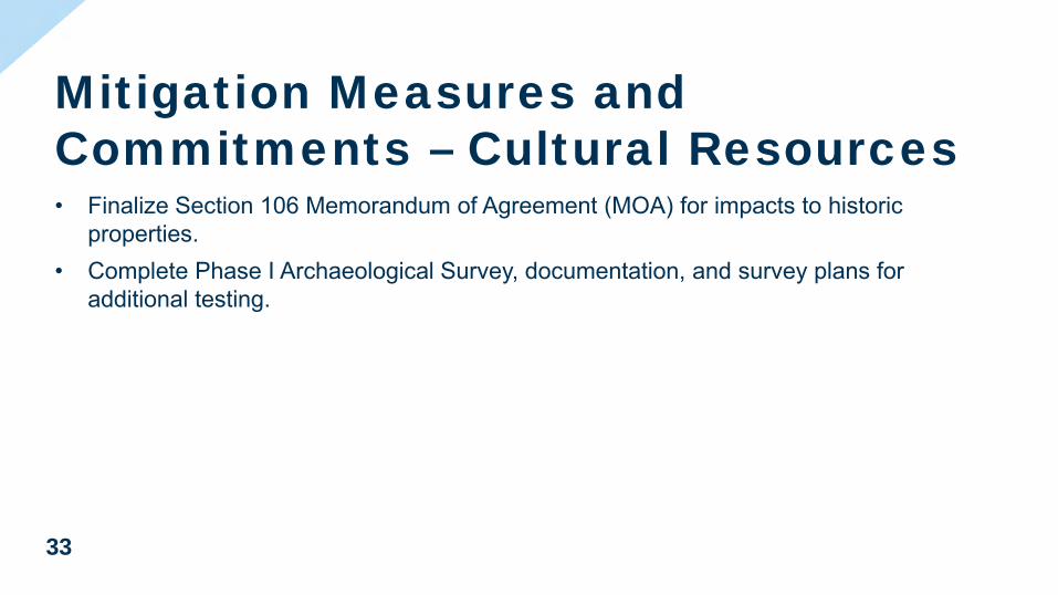
• Finalize Section 106 Memorandum of Agreement (MOA) for impacts to historic properties.
• Complete Phase I Archaeological Survey, documentation, and survey plans for additional testing.
Mitigation Measures and Commitments – Cultural Resources
Attachment 2
34
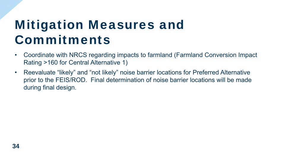
• Coordinate with NRCS regarding impacts to farmland (Farmland Conversion Impact Rating >160 for Central Alternative 1)
• Reevaluate “likely” and “not likely” noise barrier locations for Preferred Alternative prior to the FEIS/ROD. Final determination of noise barrier locations will be made during final design.
Mitigation Measures and Commitments
Attachment 2
35
PREFERRED ALTERNATIVES ENVIRONMENTAL STUDIES
Attachment 2
36
• Survey of bridges for bats (August 2018)• Wetland and Stream Delineations (July-
September 2018)• Mussel Surveys (October-November 2018)
– No threatened/endangered mussels found.
• Phase I Archaeological Surveys (October-November 2018) – No notable sites found. Deep testing will be required.
Preferred Alternatives Environmental Studies
Attachment 2
37
NEXT STEPS
Attachment 2

38
Winter 2019• DEIS Comments Due February 8, 2019**• Biological Assessment• Phase 1 Archaeological Survey ReportSpring 2019• Consulting Party Meeting #4• Waters of the U.S. Report and Jurisdictional DeterminationSummer 2019• Identification of final Preferred Alternative• IAC Meeting #5Fall 2019• FEIS/ROD Publication
Project ScheduleAttachment 2

39
QUESTIONS?
Attachment 2
THANK YOU
Attachment 2

Now – Jan. 11, 2019 2019 Late 2019 Now –
Feb. 8, 2019 2019 Late 2019
The Central Alternative is the preferred route for the proposed I-69 Ohio River Crossing. It includes a 4-lane I-69 bridge and retains one US 41 bridge.
Preferred AlternativesCentral Alternatives 1A and 1B: Two Tolling Options
Central Alternative 1A• Toll both I-69 bridge and remaining US 41 bridge
Central Alternative 1B• Toll only the I-69 bridge
The tolling options are the only difference.
Central Alternatives 1A and 1B• Build 4-lane I-69 bridge
• US 41 northbound bridge retained for two-way,local traffic
• 11.2 miles of new interstate
• 8.4 miles of I-69 on new location
• 2.8 miles of improvements to existing US 41to meet interstate standards
• New interchanges
• At existing I-69 in Indiana
• At US 60
• At existing US 41 south of Hendersonbetween Van Wyk Rd. and Kimsey Ln.
• Improvements to three existing interchanges
093017
Howard Frankland BridgeThis is what we are proposing to build in 2020.
Howard Frankland BridgeThis is how we would accommodate rail transit in the future.
US 41 Bridge
093017
Howard Frankland BridgeThis is what we are proposing to build in 2020.
Howard Frankland BridgeThis is how we would accommodate rail transit in the future.
New I-69 Bridge
• Posted at I69ohiorivercrossing.com/DEIS
2025Central Alternative 1A or 1B could open to traffic as soon as 2025, assuming funding is identified soon after the Record of Decision.
Estimated Cost: $1.497 billion*
The DEIS summarizes the I-69 Ohio River Crossing project’s study process, analysis and findings. It includes the basis for the selection of the preferred alternatives and mitigation measures proposed to address unavoidable impacts associated with the preferred alternatives.
Draft Environmental Impact Statement (DEIS)
Copies available at several locations • (see complete list at I69ohiorivercrossing.com)
Comments can be made:
(Project offices will be closed Dec. 24 – Jan. 1)
Office Hours During the Comment PeriodHenderson office: Tuesdays, Wednesdays and Fridays1970 Barrett Ct., Ste. 100, Henderson, KY 424208 a.m. to 5 p.m. and by appointment
Speakers can sign up at either hearing, and all comments will be recorded. Written comments can also be submitted.
PublicHearings
5 to 8 p.m. Presentation at 6 p.m.
HendersonMonday, Jan. 7
Henderson Community CollegePreston Arts Center
2660 S. Green St.
Evansville Tuesday, Jan. 8
Old National Events PlazaLocust meeting rooms
715 Locust St.
Public comment period to gather feedback on the DEIS
• Project Team considers all comments
• States pursue grant opportunities
• Refine tolling needs• Bi-state coordination• Development of financial plan
Final Environmental Impact Statement (FEIS) = States confirm the preferred alternative
Record of Decision (ROD) = Federal Highway Administration’s final approval of preferred alternative
Basis for Selection of Preferred • Fewest residential relocations (four relocations)• No commercial relocations• Cross-river redundancy• Lowest total cost• Fewest impacts to many sensitive natural resources:
• Wetlands• Floodways• Managed lands• Streams
Evansville office: Mondays, Tuesdays and Thursdays320 Eagle Crest Dr., Ste. C, Evansville, IN 477158 a.m. to 5 p.m. and by appointment
The ROD allows the states, with the help of available federal funds, to move forward with design, land purchases and construction.
Now – Jan. 11, 2019 2019 Late 2019
*Year-of-expenditure dollars. Also includes roadway and bridgeoperations for 35-years following completion of construction.
$200 million = Design, Right of Way, Mitigation, Procurement, Construction Inspection
$807 million = Construction Cost, 2017 $ (Includes Roadway, Bridge, Toll System, Utilities)
$255 million = Construction Inflation (Year-of-Expenditure dollars)
$234 million = Roadway and Bridge Operations and Maintenance (O&M) (35 years)
Now – Jan. 11, 2019 2019 Late 2019 Now –
Jan. 11, 2019 2019 Late 2019
• Posted at I69ohiorivercrossing.com/DEIS
The DEIS summarizes the I-69 Ohio River Crossing project’s study process, analysis and findings. It includes the basis for the selection of the preferred alternative and mitigation measures proposed to address unavoidable impacts associated with the preferred alternative.
Draft Environmental Impact Statement (DEIS)
Copies available at several locations • (see complete list at I69ohiorivercrossing.com)
Comments can be made:
(Project offices will be closed Nov. 22 – Nov. 23 and Dec. 24 – Jan. 1)
Office Hours During the Comment Period
At public hearings
On Contact Us page on project website
By email [email protected]
By mail (project o�ce)
In person(project o�ce)
Henderson office: Mondays, Wednesdays and Fridays1970 Barrett Ct., Ste. 100, Henderson, KY 424208 a.m. to 5 p.m. and by appointment
Speakers can sign up at either hearing, and all comments will be recorded. Written comments can also be submitted.
PublicHearings
EvansvilleTuesday, Dec. 4, 5 to 8 p.m.
Bosse High School1300 Washington Ave.
HendersonWednesday, Dec. 12, 5 to 8 p.m.Henderson Community College
Preston Arts Center2660 S. Green St.
Public comment period to gather feedback on the DEIS
• Project Team considers all comments• States pursue grant applications• Refine tolling needs• Bi-state coordination• Development of financial plan
Final Environmental Impact Statement (FEIS) = States confirm the preferred alternative
Record of Decision (ROD) = Federal Highway Administration’s final approval of preferred alternative
Evansville office: Mondays, Tuesdays and Thursdays320 Eagle Crest Dr., Ste. C, Evansville, IN 477158 a.m. to 5 p.m. and by appointment
The ROD allows the states, with the help of available federal funds, to move forward with design, land purchases and construction.
Now – Jan. 11, 2019 2019 Late 2019
Attachment 3
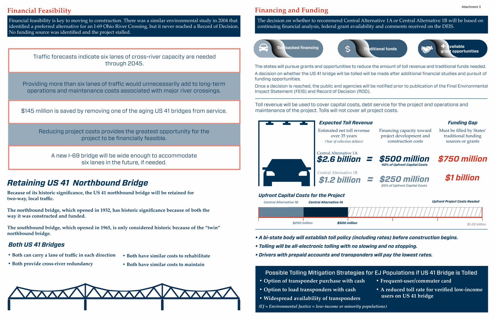
Financial Feasibility
Because of its historic significance, the US 41 northbound bridge will be retained for two-way, local traffic.
The northbound bridge, which opened in 1932, has historic significance because of both the way it was constructed and funded.
The southbound bridge, which opened in 1965, is only considered historic because of the “twin” northbound bridge.
Estimated net toll revenue over 35 years
(Year of collection dollars)
• Both can carry a lane of traffic in each direction
• Both provide cross-river redundancy• Both have similar costs to rehabilitate
• Both have similar costs to maintain
Traffic forecasts indicate six lanes of cross-river capacity are needed through 2045.
Providing more than six lanes of traffic would unnecessarily add to long-term operations and maintenance costs associated with major river crossings.
Reducing project costs provides the greatest opportunity for the project to be financially feasible.
$145 million is saved by removing one of the aging US 41 bridges from service.
A new I-69 bridge will be wide enough to accommodate six lanes in the future, if needed.
The states will pursue grants and opportunities to reduce the amount of toll revenue and traditional funds needed.A decision on whether the US 41 bridge will be tolled will be made after additional financial studies and pursuit of funding opportunities.Once a decision is reached, the public and agencies will be notified prior to publication of the Final Environmental Impact Statement (FEIS) and Record of Decision (ROD).
Toll revenue will be used to cover capital costs, debt service for the project and operations and maintenance of the project. Tolls will not cover all project costs.
Retaining US 41 Northbound Bridge
Both US 41 Bridges• A bi-state body will establish toll policy (including rates) before construction begins.
• Tolling will be all-electronic tolling with no slowing and no stopping.
• Drivers with prepaid accounts and transponders will pay the lowest rates.
Possible Tolling Mitigation Strategies for EJ Populations if US 41 Bridge is Tolled• Option of transponder purchase with cash• Option to load transponders with cash• Widespread availability of transponders
• Frequent-user/commuter card • A reduced toll rate for verified low-income users on US 41 bridge
Financial feasibility is key to moving to construction. There was a similar environmental study in 2004 that identified a preferred alternative for an I-69 Ohio River Crossing, but it never reached a Record of Decision. No funding source was identified and the project stalled.
Financing and FundingThe decision on whether to recommend Central Alternative 1A or Central Alternative 1B will be based on continuing financial analysis, federal grant availability and comments received on the DEIS.
(EJ = Environmental Justice = low-income or minority populations)
Expected Toll Revenue
Upfront Capital Costs for the Project
Must be filled by States’ traditional funding sources or grants
Funding GapFinancing capacity toward project development and
construction costs
$2.6 billion $500 million=Central Alternative 1A
$750 million40% of Upfront Capital Costs
Central Alternative 1B Central Alternative 1A Upfront Project Costs Needed
$1.25 billion$250 million $500 million
Estimated net toll revenue over 35 years
(Year of collection dollars)
States will pursue grants and opportunities to reduce the amount of toll revenue and traditional funds needed.
If additional funding sources are identified, the amount of toll funds needed and the decision of which bridges to toll will be revisited.
The States will continue to develop their financial plan.
Toll revenue will be used to cover capital costs, debt service for the project and operations and maintenance of the project. Tolls will not cover all project costs.
• A bi-state body will establish toll policy (including rates and what bridges are tolled) before construction begins.
• Tolling will be all-electronic tolling with no slowing and no stopping.
• Drivers with prepaid accounts and transponders will pay the lowest rates.
Possible Tolling Mitigation Strategies for Environmental Justice (EJ) Populations• Option of transponder purchase with cash• Option to load transponders with cash• Widespread availability of transponders
• Frequent-user/commuter card • Reduced toll rate on US 41 bridge for verified low-income users
Financing and FundingBased on current funding capabilities of the states and without additional federal or local funding, tolling both I-69 and US 41 would be necessary to supplement traditional funds.
Toll-backed financing
+ Available grant opportunities
Traditional funds
CONSTRUCTION
(EJ = low-income or minority populations)
Expected Toll Revenue
Upfront Capital Costs for the Project
Must be filled by States’ traditional funding sources
Funding Gap
$2.6 billion $500 million=
Toll-backed financing
+ Available grant opportunities
Traditional funds
CONSTRUCTION
Toll-backed financing
+ Available grant opportunities
Traditional funds
CONSTRUCTION
With both bridges tolled:
$1.2 billionOnly I-69 bridge tolled:
Financing capacity toward project development and
construction costs
$250 million=
$750 million40% of Upfront Capital Costs
$1 billion20% of Upfront Capital Costs
Only I-69 Bridge Tolled Both Bridges Tolled Upfront Project Costs Needed
$1.25 billion$250 million $500 million
$1.2 billionCentral Alternative 1B
$250 million= $1 billion20% of Upfront Capital Costs
Attachment 3
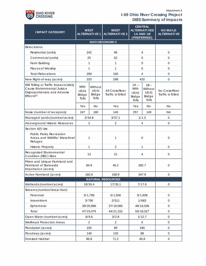
I-69 Ohio River Crossing Project DEIS Summary of Impacts
IMPACT CATEGORY WEST ALTERNATIVE 1
WEST ALTERNATIVE 2
CENTRAL ALTERNATIVES
1A AND 1B (PREFERRED)
NO BUILD ALTERNATIVE
SOCIOECONOMIC
Relocations
Residential (units) 242 96 4 0
Commercial (units) 25 62 0 0
Farm Building 1 1 0 0
Places of Worship 1 1 0 0
Total Relocations 269 160 4 0
New Right-of-way (acres) 333 298 420 0
Will Tolling or Traffic Impacts Likely Cause Environmental Justice Disproportionate and Adverse Effects?1
With US 41
Bridge Tolls
Without US 41 Bridge
Tolls
All Cross-River Traffic is Tolled
1A – With US 41
Bridge Tolls
1B – Without
US 41 Bridge
Tolls
No Cross-River Traffic is Tolled
Yes No Yes Yes No No
Noise (number of receptors) 167 180 140 257 149 NA
Managed Lands (number/acres) 2/54.8 3/57.1 1/1.3 0
Aboveground Historic Resources 2 2 4 0
Section 4(f) Use
Public Parks, Recreation Areas, and Wildlife/ Waterfowl Refuges
1 1 0 0
Historic Property 1 2 1 0
Recognized Environmental Condition (REC) Sites 13 21 4 0
Prime and Unique Farmland and Farmland of Statewide Importance (acres)
84.9 46.2 382.7 0
Active Farmland (acres) 182.6 168.9 347.9 0 NATURAL RESOURCES
Wetlands (number/acres) 18/55.4 17/35.1 7/17.6 0
Streams (number/linear feet)
Perennial 5/1,799 5/1,556 3/1,608 0
Intermittent 3/790 2/511 1/683 0
Ephemeral 39/20,886 37/19,085 49/16,036 0
Total 47/23,475 44/21,152 53/18,327 0
Open Water (number/acres) 6/9.6 3/2.8 1/12.7 0
Wellhead Protection Areas 2 2 0 0
Floodplain (acres) 105 89 190 0
Floodway (acres) 149 120 88 0
Forested Habitat 96.8 71.2 45.8 0
Attachment 4
I-69 Ohio River Crossing Project DEIS Summary of Impacts
IMPACT CATEGORY WEST ALTERNATIVE 1
WEST ALTERNATIVE 2
CENTRAL ALTERNATIVES
1A AND 1B (PREFERRED)
NO BUILD ALTERNATIVE
DESIGN/COSTS
Length (miles)
New Interstate 8.2 8.1 8.4 0
Existing US 41 2.9 2.9 2.8 0
Total 11.1 11.0 11.2 0
Cost (in millions, year of expenditure)
Design, Approvals, Right of Way, Mitigation, Procurement, Construction Inspection2
$312 $352 $200 $17
Construction $1,245 $1,221 $1,062 $0
Roadway/Bridge Operations and Maintenance (35 years) $2523 $107 $2343 $293
Total $1,810 $1,680 $1,497 $310
Potential Toll Revenue (in millions, year of collection) $1,100 – $2,900 $2,600 $1,200 (1B) –
$2,600 (1A) $0
1 Comparing traffic volumes and LOS under each of the build alternatives and with both tolling scenarios, all the alternatives would reduce traffic volumes and improve LOS on US 41 as compared with the No Build alternative, even with the removal of one or both of the US 41 bridges. Therefore, the EJ analysis did not identify any disproportionately high and adverse traffic related impacts to EJ populations.
2 Each of the alternatives, including the No Build Alternative, includes costs associated with the completion of the NEPA process.
3 Includes the remaining US 41 bridge.
Attachment 4
I-69 Ohio River Crossing ProjectDraft Environmental Impact Statement
Appendices
APPENDIX A-3 Central Alternative 1 (Preferred) Environmental
Features Maps
Clarification Note for Central Alternative 1: Central Alternatives 1A and 1B as described in the DEIS are physically the same alternative. The only difference between them is that Central Alternative 1A would include tolls on both the new I-69 bridge and on the US 41 bridge. Central Alternative 1B would only include tolls on the new I-69 bridge. Any reference in this document to Central Alternative 1 applies to both Central Alternative 1A and Central Alternative 1B.
Attachment 5
LINK to Maps