Embed Size (px)
Citation preview
Participatory Monitoring of Elephants in Community Owned Lands of South Garo Hills – Meghalaya
Samrakshan Trust Meghalaya
December 2006
2
Contents
Section Category
Page No.
Part 1
Background 1.1 The Landscape. 1.2 The Rationale for Elephant Monitoring. 1.3 Review of literature on the Elephants in the Garo Hills.
3
Part 2
Methodology
8
Part 3
Project Findings 3.1 Preliminary ideas. 3.2 Seasonality 3.3 Group Size 3.4 Some observations on the Akings covered in the study.
9
Part 4
The Future
16
Part 5
Acknowledgements
19
Part 6
References
20
3
Part 1 Background
1.1 The Landscape
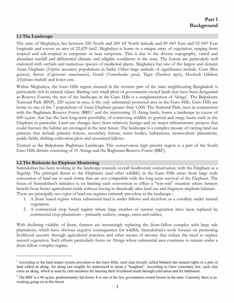
The state of Meghalaya, lies between 250 North and 260 10' North latitude and 89 045' East and 92 045' East longitude and covers an area of 22,429 km2. Meghalaya is home to a unique array of vegetation, ranging from tropical and sub-tropical to temperate or near temperate. This is due to the diverse topography, varied and abundant rainfall and differential climatic and edaphic conditions in the state. The forests are particularly well endowed with orchids and numerous species of medicinal plants. Meghalaya has one of the largest and densest Asian Elephant (Elephas maximus) populations in India. Other large animals of significance include, Gaur (Bos gaurus), Serow (Capricornis sumatraensis), Goral (Nemorhaedus goral), Tiger (Panthera tigris), Hoolock Gibbon (Hylobates hoolock) and lesser cats.
Within Meghalaya, the Garo Hills region situated in the western part of the state neighbouring Bangladesh is particularly rich in natural values. Barring very small plots of government owned lands that have been designated as Reserve Forests; the rest of the landscape in the Garo Hills is a conglomeration of Akings1. The Balpakram National Park (BNP), 220 sq.km in area, is the only substantial protected area in the Garo Hills. Garo Hills are home to one of the 7 populations of Asian Elephant greater than 1,000. The National Park, seen in conjunction with the Baghmara Reserve Forest (BRF)2 and the intervening 33 Aking lands, forms a landscape in excess of 600 sq.km. that has the best long-term possibility of conserving wildlife in general and mega fauna such as the Elephant in particular. Land use changes have been relatively benign and no major infrastructure projects that could fracture the habitat are envisaged in the near future. The landscape is a complex mosaic of varying land use patterns that include primary forests, secondary forests, water bodies, habitations, monoculture plantations, paddy fields, shifting cultivation plots and associated fallows.
Termed as the Balpakram Baghmara Landscape This conservation high priority region is a part of the South Garo Hills district consisting of 33 Akings and the Baghmara Reserve Forest (BRF).
1.2 The Rationale for Elephant Monitoring Samrakshan has been working in the landscape towards overall biodiversity conservation, with the Elephant as a flagship. The principal threat to the Elephants (and other wildlife) in the Garo Hills arises from large scale conversion of land use to such forms that are not compatible with the long term survival of the Elephant. The focus of Samrakshan's initiative is on limiting such conversion to effect a "win-win" situation where farmers benefit from better agricultural yields without having to drastically alter land use and fragment elephant habitats. There are principally two types of land use regimes currently prevalent in the landscape :
1. A jhum based regime where substantial land is under fallows and therefore as a corollary under natural vegetation.
2. A commercial crop based regime where large swathes of natural vegetation have been replaced by commercial crop plantations – primarily cashew, orange, areca and rubber.
With declining viability of jhum, farmers are increasingly replacing the jhum-fallow complex with large sale plantations, which have obvious negative consequences for wildlife. Samrakshan’s work focuses on promoting livelihood security through agricultural practices and other means of income that reduce the need to replace natural vegetation. Such efforts particularly focus on Akings where substantial area continues to remain under a jhum fallow complex regime.
1 According to the land tenure system prevalent in the Garo Hills, each clan (locally called Mahari) has tenural rights to a plot of
land called an aking. An aking can roughly be understood to mean a "kingdom". According to Garo customary law, each clan
owns an aking, which is used by clan members for meeting their livelihood needs through cultivation and for habitation.
2 The BRF is a 40 sq.km. predominantly Sal forest. It is one of the few government owned forests in the state. Currently there is no
working going on in this forest.
4
A significant hindrance in this effort has been the absence of reliable information and understanding on the manner in which elephants use Aking lands. There exists very scanty and unreliable information on elephant numbers and associated demographic characteristics and absolutely no information on their ranging patterns in the landscape.
The absence of such information makes it difficult to undertake land use planning with local communities since elephant movement and use cannot be factored into the land use plans. The framing of land use plans (and subsequent livelihood strengthening activities) in the absence of such information would potentially exacerbate conflict and continue fragmentation of elephant habitats.
In order to facilitate elephant-friendly land use planning, a strong need to understand elephant ranging and demographic characteristics was felt within the Samrakshan team. Such information would also help Samrakshan prioritise spaces within the landscape for conservation action.
Thus the objectives of the exercise described in this report are the following:
1. Get a reliable estimate of the number of animals living in or otherwise using the landscape;
2. Understand elephant ranging patterns and the reasons behind these;
3. Identify high priority spaces for elephants within the landscape
4. Develop a preliminary understanding of human elephant conflict within the landscape.
As a first step in this process, we reviewed what exiting literature told us about elephant numbers, conflict and ranging in the Garo Hills. A summary of this literature review is described in the next section.
Fig. 1. Satellite image showing the locations of the akings in south Garo hills, Meghalaya.
5
1.3 Review of Literature on Elephants in the Garo Hills A brief summary of literature pertaining to elephants in the Garo Hills, especially South Garo Hills, has been presented below. The emphasis has been to document the elephant numbers presented by successive departmental counts and the gradual progression of research on elephants in general and HEC in particular. The various remedial suggestions to control conflict have also been highlighted. 1981, Das Choudhury Report on the first elephant census conducted by the State Forest Department (FD) and presented at the first meeting of the ‘North-east India task force of the Asian elephant specialist group’. A census was conducted in the then proposed Balpakram Wild Life Sanctuary (WLS). The total area covered was 582 sq. km., which included the proposed sanctuary as well as some buffer areas. The total number of elephants recorded was 857 (471 adults, 236 sub-adults and 150 calves). This report was further modified and some additional information added and presented as Gogoi and Das Choudhury, 1982. The elephant numbers were updated to 860. 1981, Gogoi Discusses the census methods used and the management of wild elephants in the same ‘North-east India task force of the Asian elephant specialist group’ meeting at Shillong. Elephant depredation is described as ‘serious’ in the Garo hills. It also admits that the compensation paid for crop damage is not commensurate with the loss and unless that is rectified the conflict will grow and death and injury to elephants will follow. HEC reported to be ‘round-the-year’ with maximum damages caused during the cropping seasons. Measures suggested to decrease conflict include chasing away herds by bursting crackers or beating drums and firing blanks. Use of departmental koonkie elephants to chase away wild elephants is suggested as a last resort. Plans are also outlined to start two ‘anti-depredation squads’ in the state at Williamnagar and Nongstoin. 1985, Kumar and Rao Elephant numbers are quoted from the 1981 census report prepared by the Meghalaya FD as 860 in Balpakram National Park (NP), proposed Wildlife Sanctuary at that time. The report states that elephants raid adjoining jhum fields for crops like tapioca, sweet potato, pineapple, banana and other cultivated plants in the months of February and March. 1992-93, State FD Census conducted by the State FD estimates 1850 elephants (1460 direct sightings and 390 from indirect evidence) in the Garo hills. South Garo Hills district is estimated to have a population of 910 with 591 of them residing within Balpakram NP. 1996, Williams and Johnsingh The report presents no new information on elephant numbers; Forest Department census data of 1992-93 is quoted. Dung encounter rate surveys on trails were done in four areas – West Garo hills, East Garo hills, Nokrek-Angratolli RF, South Garo hills and West Khasi hills covering the entire elephant population in Garo hills to determine the respective relative densities. South Garo hills had the highest relative density followed by West Garo hills. Habitat preference analysis based on the dung encounter surveys in the seven habitat types showed that elephants preferred jhum fallows between 3-7 years above all others. Assessment of the HEC was done only for the West Garo hills based on State FD database on elephant depredations, human and elephant deaths as well as an economic evaluation of the level of damage. This included data from 1989 to 1995. Crop damage was found to have occurred mostly between June and December with peaks in July and August and a minor peak in November. Various long term and short terms measures are suggested. Three ‘elephant corridors’ across Garo hills were identified and evaluated. 1997, Williams and Johnsingh
6
This uses information from the mela-shikar operation of 1980 and analyses the age-sex ratio of the captured elephants. Data from this was modelled to find the effect of removal of different age-sex categories of elephants on the overall population viability of the local population. Occasional removal of some individuals from the population by the Forest Department is suggested to control the population as well as to be ‘shown as making a sincere effort to solve elephant-human conflict’. Capture of young adult females is recommended if the objective is to reduce the current intensity of conflict instead of preserving the population viability in the long-term. 2000, Gurung and Lahiri-Choudhury Part I is a comprehensive review of the HEC in Meghalaya as part of the Project Elephant initiative for elephant states. Information sources are the official records of Meghalaya FD (elephant census figures, elephant deaths, human deaths caused by elephants, details of forests, claims filed for compensation of elephant damage to crops and property and claims settled) and census office (population figures and ethnic composition of the villages). Villagers were also directly interviewed in some representative villages to gather additional information. The information is from 1992 to 1997. The elephant population in Meghalaya is described as the most threatened and pressurised. This has been illustrated with the fact that most of the elephants exist in forested areas, which have no legal protection. The concept of ‘elephant corridors’ is considered as a misnomer except for the link between Siju WLS and Rewak RF (which is recommended to be acquired by the forest department). The futility of having narrow linkages between scattered patches of reserve forests across private/community land is considered as an unsuitable strategy. Instead, ‘mini-cores’ are to be identified and efforts concentrated on those areas. The report quotes PD Stracey from 1967 where he mentions that elephants in the Garo hills have been an ‘endemic’ problem leading to crop and property depredation and loss of human life. Shortening jhum cycles are identified as the single most important factor behind increasing HEC in the state. Numerous recommendations are made to decrease the magnitude of the conflict such as increased protection and law enforcement of the existing elephant areas, alternative cropping patterns, eco-development, education and awareness and anti-depredation measures. 2001, Gurung and Lahiri-Choudhury Part II of the report presents a detailed analysis of the conflict in the different habitation areas comprising the elephant range. Compensation details, period of maximum depredation, group structure of the marauding animals, crops affected, nature of damage, frequency of damage, market value of damage and various other factors are analysed based on the existing information. Rongara Community Development Block in South Garo hills is of special importance as that is where Samrakshan Trust’s current efforts are concentrated. Some of the important findings for this area are: (a) Elephants were found to be sheltering in the P.A.’s during the dry season when there are no crops in the
fields. The onset of monsoons and the cropping season see them emerging. Thus the villages on the fringes of the Protected Areas (PA’s) are seen to be more affected by conflict.
(b) Depredation was found to be deliberate and not because of transit between two habitat patches. (c) Unattached males were more responsible for property damage although family groups also caused damage.
All human deaths and injuries were also by adult males. (d) Without a change in land-use pattern there is little hope of reducing the level of depredation. 2002, Marak, T.T.C. Elephant numbers for the entire state of Meghalaya are quoted (1840 elephants) from a departmental census carried out in 1997, which is a drastic decline from the 1993 state figure of 2872. This decline is attributed to the lack of access to various areas in the state by census personnel due to army operations. The compensation scheme for crop damage is reported to be drastically short of funds with an outstanding amount of Rs. 87.84 lakhs as on April 1999. Various management recommendations are made and stress laid on further research. The report suggests maximizing protection efforts in the few months that witness the maximum crop raiding.
7
2002, State FD 2002 elephant census conducted by the Meghalaya FD provides elephant numbers for the whole state which is divided into four sectors – Jaintia hills, West Khasi hills and Ri Bhoi, East and West Garo hills and South Garo hills. These sectors are further divided into ‘counting zones’. The total elephant population for South Garo hills is reported to be 609 while the entire Garo Hills elephant population is estimated to be 1193. The ‘counting zones’ of immediate interest to Samrakshan Trust’s conservation effort are (a) GH/XIX (Siju-Rongchuagal-Rongcheng-Balpakram) – 95 elephants in 185 sq.km. (b) GH/XX (Baghmara-Halwa Dambuk- Balpakram) – 107 elephants in 880 sq.km. (c) GH/XXI (Mahadeo-Chimitap-Balpakram) – 84 elephants in 282 sq.km. 2002, Marcot et al. The report uses elephant census data from the 1993 and 1997 census conducted by the State FD to compare elephant densities across vegetation and land cover categories determined from 1998 remote sensing data and ground truthing. Elephant densities were found to be least in (a)>10% bamboo and secondary forest and (b)>10% scrub and abandoned jhum fields (fallow jhum 3 – 6 years). Highest elephant densities were found in areas with >25% semi evergreen forest (old secondary forests 15-30+ years). Seven ‘elephant corridors’ were also identified all of which were on community land. Does not suggest any answers to overcome problems of the increasing conflict and the identification of elephant movement routes within community land. 2004, Williams In addition to the conclusions from the 1996 report already discussed above, questionnaire responses were used to find costs to humans and elephants of the conflict. Perceptions of HEC affected people, their response to elephants, change in land-use patterns, failure of mitigation measures such as compensation exposed the fact that the conflict was assuming serious proportions. The report concludes from the rising deaths of wild elephants that poaching has also increased. 2005, WTI This publication provides a figure of 1700 elephants for the Garo Hills Elephant Reserve. Out of the 3500 sq.km. elephant reserve, only 410 sq.km. is quoted to be under control of the State FD It also states that the setting up of cement and limestone mining operation near Siju WLS would disrupt the movement of elephants between Balpakram and Nokrek National Parks. A number of ‘elephant corridors’ are identified and evaluated based on their ecological significance and conservation feasibility.
8
Part 2 Methodology
While designing the methodology for this study, we were keen to capitalise upon the traditional ecological knowledge among local communities in the landscape and at the same time provide such people with an opportunity to participate actively in such an enterprise. Further, we had to be cautious that the study should not be contingent upon the availability of a professional wildlife biologist since at the time of initiating the study we did not have a biologist on the team.
In view of these factors, the following methodology is being adopted for the study :
(a) A reliable local person who can act as a record-keeper has been identified for each of the 6 akings where the monitoring has so far been undertaken3. In akings that are spread over a large geographical area more than one record keeper has been identified and the areas of operations have been demarcated for each of these informants.
(b) The boundaries of 3 out of the 6 project akings have been delineated with the help of a GPS.
(c) To procure support and cooperation of the people in the akings, meetings have been conducted with the head men (Nokmas) and other influential people of these akings. The objectives of this exercise have been publicized widely among the people. This has been done by putting up posters and holding interactions at tea stalls and other places frequented by people.
(d) The villagers have been requested to pass on details of every instance of elephant presence and movement in their aking to the record keeper.
(e) Based on information reported by villagers, the record keeper enters the data in a notebook supplied to him. This notebook has a structured format in the local language to enable the data to be recorded systematically.
(f) Training sessions are conducted at regular intervals at Samrakshan Trust's field office to ensure a common level of understanding within the record-keepers and thus uniformity in the data collected. These sessions also present a platform to the informants to voice their opinions and suggestions regarding the project.
(g) Samrakshan Trust personnel visit the informants at regular intervals and collate the data collected from the informants' note books on their data sheets. The informants then accompany the Samrakshan personnel to the exact spot where elephant presence has been noted and the GPS location of each spot is recorded.
3 Though eventually we intend to expand the study to all the 33 Akings in the landscape, the study has been initiated in the 6
Akings where Samrakshan is undertaking other livelihood interventions as well.
9
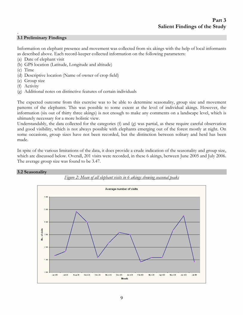
Part 3 Salient Findings of the Study
. 3.1 Preliminary Findings Information on elephant presence and movement was collected from six akings with the help of local informants as described above. Each record-keeper collected information on the following parameters: (a) Date of elephant visit (b) GPS location (Latitude, Longitude and altitude) (c) Time (d) Descriptive location (Name of owner of crop field) (e) Group size (f) Activity (g) Additional notes on distinctive features of certain individuals The expected outcome from this exercise was to be able to determine seasonality, group size and movement patterns of the elephants. This was possible to some extent at the level of individual akings. However, the information (six out of thirty three akings) is not enough to make any comments on a landscape level, which is ultimately necessary for a more holistic view. Understandably, the data collected for the categories (f) and (g) was partial, as these require careful observation and good visibility, which is not always possible with elephants emerging out of the forest mostly at night. On some occasions, group sizes have not been recorded, but the distinction between solitary and herd has been made. In spite of the various limitations of the data, it does provide a crude indication of the seasonality and group size, which are discussed below. Overall, 201 visits were recorded, in these 6 akings, between June 2005 and July 2006. The average group size was found to be 3.47. 3.2 Seasonality
Figure 2: Mean of all elephant visits in 6 akings showing seasonal peaks
10
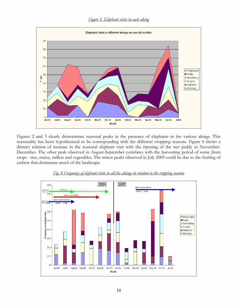
Figure 3. Elephant visits in each aking
Figures 2 and 3 clearly demonstrate seasonal peaks in the presence of elephants in the various akings. This seasonality has been hypothesized to be corresponding with the different cropping seasons. Figure 4 shows a distinct relation of increase in the seasonal elephant visit with the ripening of the wet paddy in November-December. The other peak observed in August-September correlates with the harvesting period of some jhum crops - rice, maize, millets and vegetables. The minor peaks observed in July 2005 could be due to the fruiting of cashew that dominates much of the landscape.
Fig. 4 Frequency of elephant visits to all the akings in relation to the cropping seasons
11
The early peak in June 2006 and the sharp decrease of reported incidents in July 2006 are difficult to explain. It is felt that one reason could be that the degree of effort on part of informants in different akings may be extremely variable. 3.3 Group Size
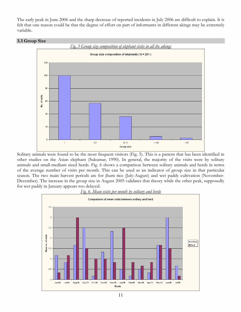
Fig. 5 Group size composition of elephant visits in all the akings
Solitary animals were found to be the most frequent visitors (Fig. 5). This is a pattern that has been identified in other studies on the Asian elephant (Sukumar, 1990). In general, the majority of the visits were by solitary animals and small-medium sized herds. Fig. 6 shows a comparison between solitary animals and herds in terms of the average number of visits per month. This can be used as an indicator of group size in that particular season. The two main harvest periods are for jhum rice (July-August) and wet paddy cultivation (November-December). The increase in the group size in August 2005 validates that theory while the other peak, supposedly for wet paddy in January appears too delayed.
Fig. 6. Mean visits per month by solitary and herds
12
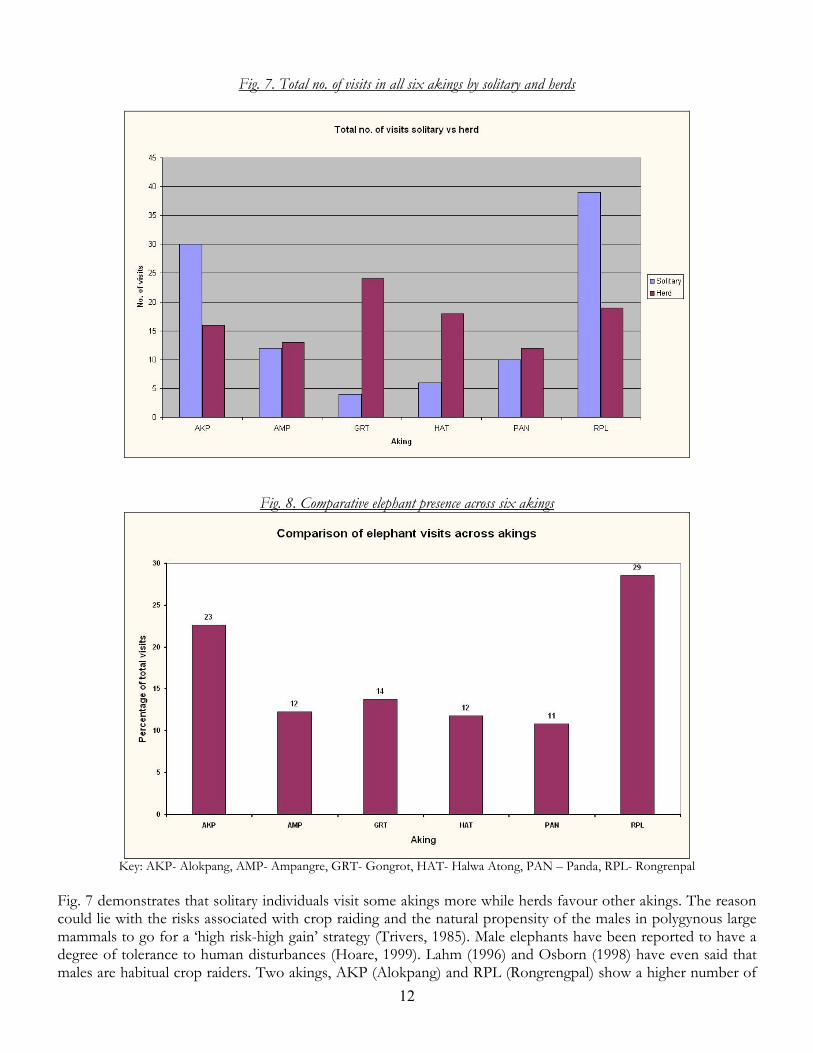
Fig. 7. Total no. of visits in all six akings by solitary and herds
Fig. 8. Comparative elephant presence across six akings
Key: AKP- Alokpang, AMP- Ampangre, GRT- Gongrot, HAT- Halwa Atong, PAN – Panda, RPL- Rongrenpal
Fig. 7 demonstrates that solitary individuals visit some akings more while herds favour other akings. The reason could lie with the risks associated with crop raiding and the natural propensity of the males in polygynous large mammals to go for a ‘high risk-high gain’ strategy (Trivers, 1985). Male elephants have been reported to have a degree of tolerance to human disturbances (Hoare, 1999). Lahm (1996) and Osborn (1998) have even said that males are habitual crop raiders. Two akings, AKP (Alokpang) and RPL (Rongrengpal) show a higher number of
13
solitary visits. These two are also the most visited akings as shown in Fig. 8. The landscape in these two is also more open with less of adjoining cover, which the elephants can use. Thus the risk of visiting these areas is more than the other akings. GRT (Gongrot) and AMP (Ampangre) on the other hand have plenty of good cover in close proximity of the crop fields which also allows them to retreat very fast if threatened. HAT (Halwa Atong) is a mixture of the two different landscape elements mentioned above; however, there is a strong reason to believe that all incidents are not getting reported to the informant in this aking. This may be a cause of bias and preventing a clearer picture from emerging. PAN (Panda) consists of two different hamlets, which have totally different levels of elephant movement within. This may not be showing up in the combined data for the whole aking. 3.4 Some Observations on the Akings covered in the Study Data on elephant presence and movement is available for the following six akings from June 2005 to July 2005. Alokpang This aking is situated to the east of Simsang river to its west and north of the BRF. Cultivation here occurs along the banks of the river and there also is a relatively significant land mass under “wet paddy” cultivation. The proximity of the BRF and aking forest allows the elephants to raid the crops by crossing the Simsang river under cover of darkness and return to the cover and safety of the forest before daybreak. Discussions with villagers also suggests that the conflict has increased dramatically only in the last 5 to 6 years. The significance of the river as a barrier is completely nullified, as the elephants are able to cross at any time of the year as demonstrated by their crossing in the peak monsoon. Rongrengpal GPS points for this aking show a dense cluster to the northwest of the aking. This area is adjacent to an aking forest from where the elephants approach. Interestingly, this particular area is dominated by cashew and areca orchards neither of which is very palatable to elephants. Bananas were grown earlier, but because of the persistent movement of the elephants through the area, it was discontinued. Discussions with villagers also suggest that elephants do not cause any damage most of the time and simply pass through their orchards or near their homes. Many of the data points for this particular aking clustered towards the northwest are caused by elephants moving along an elephant trail which allows them access from the adjoining aking forest to the lower areas of the aking where palatable crops are planted. Over the years, human habitation has settled on both sides of the trail, which is also used as a footpath by people. Thus the visibility of the elephants is more pronounced and they are detected more often. However, the lack of any palatable food plants in this area does not keep them here for too long. Areca and cashew are not particularly favoured by them and banana is no longer grown in this area because of constant elephant movement. The conflict with people is only in terms of accidental encounters with elephants on the path or damage to their houses while passing. Gongrot It is one of the larger akings and is surrounded by relatively undisturbed forests including the BNP. The data from this aking suggests that elephant movement is in two separate clusters. The major cluster is towards the southeast of aking near the boundaries of the BNP and the two other adjoining akings - Kunchung and Dambuk Atong. These points are mostly in crop fields and crop damage is involved. Elephants are also known to use a path used for inter-village movement by people reportedly because of the presence of salt licks along the way. So far this has not been verified in the field. The other group of points conversely are few and scattered. On closer verification of the data, most of these appear to be non-conflict points where elephants have been spotted near a water body or passing at a distance. In terms of conflict and crop damage, the scattered points towards the centre of the aking are not serious. These are caused by elephant presence around areas where people may have opportunistically observed them such as streams. There are no major incidents of crop raiding in one year’s data that has been collected in this area. The data collected from the south east of the aking is however an area where raiding occurs frequently. This is mainly due to two reasons; (i) the proximity of a number of jhum fields with
14
palatable crops like rice in very close proximity of the BNP allow the elephants the opportunity to raid and retreat into the nearby forest; (ii) an elephant trail, which runs through the fields and enters the BNP and is also used by people, may increase the likelihood of spotting elephants and hence reporting them. This area also has paths, which are the inter-village access routes between Gongrot and the adjacent Kunchung and Dambuk akings. Elephants have been spotted on these paths frequently. Halwa Atong The pattern of elephant movement across this aking lacks any precise pattern and is quite widely dispersed. Field observation reveals large areas of lowland paddy cultivation close to the Rongru stream. Various studies on elephants have found paddy to be the most preferred item for raiding elephants wherever available, suggesting that crop raiding would be prevalent here. Towards the south-eastern part which is more hilly, jhum rice is grown on the slopes situated right next to the community forest from which elephants can raid in relative safety. A casual comment by an inhabitant that 'elephants come from all sides' seems to actually have some truth in the present context. Wet paddy cultivation dominates a large part of this aking land because of the presence of crisscrossing streams and flat land. The scattered distribution of elephants suggests that they have access to most parts of the aking. The presence of community forests to the southeast and east of the aking explain the crop raiding that takes place on the periphery. These areas are more undulating than the rest of the aking and cultivation is primarily jhum rice and vegetables, which in some cases are grown exactly beside the community forest creating a 'hard edge'. The scattered patches of community forests may be acting as temporary shelters for the animals before they raid the paddy crop. Movement southwards from the Gongrot community forests (which are contiguous to the BNP) is also a possibility. Ampangre Elephant movement is restricted to the western and south western side of Ampangre aking. A large portion of this aking, especially the southern side borders the BRF. The cluster to the southwest is concentrated around the tar road from Baghmara to Alokpang. The Jawahar Navodaya Vidyalaya campus and the shops and houses along the road comprise the data points in the southwest. The elephant presence on the western side is clustered around the border with Alokpang in and around the community forest of Ampangre which in turn is linked to the BRF. Discussions with locals reveal that elephant presence and movement within the aking has remained constant. This could mean that elephants have been using certain trails within the aking for a very long time and crop raiding may not be the sole reason for their presence. Ampangre is located adjacent to the BRF and shares an extensive boundary with it in the south and southwest. It is no surprise that all the elephant detections are also from that area. The smaller of the clusters located in the southwest appear to be caused by elephants moving along the pucca road running through BRF. Damage to the houses and shops along the road and the adjoining JNV campus suggest that elephants use the road frequently. The presence of old dung piles on the road support this idea. The other zone of elephant activity is observed at the western border of the aking, where it borders Alokpang aking. This area lies at the edge of the Ampangre community forest and the number and size of the affected crop fields are very low compared to the number of times elephants have visited the area. A striking feature about this area is that it is excellent elephant habitat with a perennial stream, bamboo clumps along it and scattered patches of grasses. The Baghmara RF is very close and it is almost certain that the elephants are constantly moving to and from the BRF. The presence of a large expanse of agricultural fields bordering the Simsang river in the adjoining Alokpang aking could also be a reason for elephant presence in this area. Panda There are two separate hamlets (gittims), which are separated by a distance of almost 2 kms, and the level and nature of elephant related conflict is different in both these areas. Bolsalgre has very few crops or plantations because of the easy availability of jobs with the National Building Construction Corporation (NBCC), which is engaged in extensive road laying work in this area. This has resulted in a decrease in elephant movement in the area. In Wagekona, farming is still the principal occupation and there are extensive jhum fields of rice, tapioca and other vegetables in very close proximity of the BRF which is separated only by the Panda stream. Elephants frequently raid these fields and retreat back into the jungle. Raiding has however been seen to be markedly lower
15
in the months of June, July and August. Panda lies right next to the BRF with only the Panda river separating the BRF from the habitations and crop fields. The two gittims of Bolsalgre and Wagekona have had to deal with elephants in different degrees. Bolsalgre has, in the last three to four years moved away from the typical farming lifestyle to depend heavily on regular jobs and an assured income. This has led to an almost total shutdown of agriculture and the crop fields are all lying fallow. Some orchards persist, albeit with little or no maintenance. The absence of crops has resulted in a marked decrease of elephant movement in this area, as understood from discussions with locals, and conflict being minimal in this area. However, the road construction is not a permanent activity and is likely to wind up over the next few years. Villagers may then have no other option other than to resume farming. Wagekona, situated 2 km to the north has remained unaffected by the road building work. They continue with the farming lifestyle growing most of their crops in jhum plots on hill slopes as there is no good land available for riverbed cultivation along the Panda river. The area where a majority of the crop fields are located are situated about 500m north of the habitation area. This area, known as 'Songitcham' or 'abandoned land' was the initial habitation area, but in 1972 people shifted closer to the main road running between Baghmara and Maheshkhola. The fields have however, stayed in their original locations. It is situated at a most convenient location for elephants and raiding elephants can easily cross the Panda stream from the Baghmara RF, raid crops and retreat whenever threatened.
16
Part 4 The Future
With the completion of a year’s monitoring exercise and some preliminary analysis of the data, it has become apparent that various lacunae still remain in the nature and amount of information relating to elephants in this landscape. To bridge this gap, the following measures have to be taken, some more immediate than others: 1. Tracking of aking boundaries
Currently, only three of the six study akings have been tracked and their boundaries mapped. This is a serious drawback as without mapping of the boundaries of all the akings, maps cannot be prepared and reduces the utility of the GPS locations of elephant movement areas.
2. Limitations of Record - Keepers
In some akings, the informants do not appear to be collecting all information relating to elephant presence. This may be due to lack of time or interest on the part of the record-keeper or the villagers or both. On the other hand, record-keepers in other akings have been very meticulous in collecting information, cross checking it themselves most of the time, thus creating inequality in the effort involved. This problem will be addressed and if necessary personnel will be changed. Interactions with the villagers are also necessary to assure them of the importance of reporting the information. Frequent interactions among the record-keepers are also necessary, which is proposed to do be done over the following months.
3. Amendment in the data collection format Some minor changes will be introduced in the data collection format at the level of the record-keeper as well as the collating staff. For the informant, the data sheet will be made relatively close ended cutting down on the chances of fabrication. For the office staff who make the fortnightly visits to record the GPS locations, additional information on elephant tracks and their direction of movement (if still visible) are to be recorded. Landscape and habitat characteristics are also to be recorded.
4. Expansion of the project to other akings A landscape level perspective will only emerge after information for elephant presence has been collected from all the thirty three akings. Considerations of logistics and manpower do not allow that immediately. However, five additional akings have been identified to expand the current exercise. These are Siju, Rewak, Balkal, Hangsapal and Halwa Ambeng. Expanding the exercise to the first four would ensure information is available from the entire northern part of the BBL. Halwa Ambeng is the only other aking which touches the BRF and should give valuable information on movement to and from the BRF. Expansion of the project to other areas would also require more people and essential equipment such as GPS and compasses.
In addition to these immediate measures, implementation of which can be started immediately, other measures are also conceptualised which would give us a more holistic view of elephant movement patterns across the larger landscape. 1. Boat Transects
The current report proves that elephants are able to cross rivers with ease even in the monsoon. The Simsang river is the largest river in the landscape and elephants have been found to be crossing this river at certain points. It would be extremely useful to know the elephant movement points across Simsang as in many cases they approach the agricultural lands from the Reserve forests or the aking forests situated on the other side of the river. Boats are available from Baghmara to Siju, and the boatmen are well acquainted with the movement of elephant routes often sighting them too. This can be repeated on a periodic basis.
17
2. Mapping and monitoring of trails It is important to have an independent enumerative exercise which would give us some idea about the relative densities of the elephant populations around the akings. Limited manpower, steep terrain and the presence of gorges rules out the use of line transects. Elephant and human trails, roads as well as streams provide the best coverage of the area. These need to mapped around all the akings. A network of all these trails and routes may then be decided to maximise coverage and walked on a periodic basis. These walks would be able to collect the following data:
a. Direct sightings Sightings of elephants whenever they occur can be recorded. Information on their age-sex classification as well as distinctive identification features of particular individuals can also be recorded.
b. Dung piles The difficulty of sighting animals in tropical forest habitats has been acknowledged by various researchers and hence indirect methods for determining elephant presence becomes important. Dung piles will be recorded and aged according to established methodology. During this exercise, dung piles can also be investigated to check for the remains of crops.
c. Habitat classification Predetermined habitat classes can be recorded at certain intervals. Other defining habitat characteristics such as canopy cover and presence of elephant food trees can also be recorded.
3. Study to find out efficacy of short term measures There are various short term measures in use to prevent access of elephants to habitations and crop fields. Methods adopted by local people do not appear to be particularly effective in deterring elephants. Setting up electric fences, elephant proof cement trenches, chilli aerosols etc are various measures are being tried all over Asia and Africa. Not all of these would work here; a study to determine what measures would work in which area would be extremely useful. This would be crucial to garnering local support reassuring the villagers of our commitment to solve the problem. It must however be recognised that this is not a long term solution to the problem of conflict.
4. Official help in dispensing compensation This is another step which could help this initiative win the support of the local community which is crucial in a long-term intervention. Samrakshan could act as an intermediary and explore ways to get long overdue compensation amounts for crop damage released for affected families.
18
Part 5 Acknowledgements
1. Dr. M D Madhusudan for guiding us in designing the methodology during his visit to Baghmara during April
2005. 2. The informants in the akings for collecting the data. 3. The people in the akings for supporting the activity.
19
Part 6 References
Barnes, R. F. W, S. Azika and B. Asamoah-Boateng. 1995. Timber, Cocoa and crop-raiding elephants: a preliminary study from southern Ghana. Pachyderm. 19:33-38. Das Choudhury, G. 1981. Elephant status survey and census in Meghalaya. Pp. 23-27. In: Proceedings of the first meeting of the northeast India task force, Asian Elephant Specialist Group. IUCN/SSC. Shillong. Gogoi, P.C. 1981. Action plan for census of elephant and its management in Meghalaya. Pp. 28-31. In: Proceedings of the first meeting of the northeast India task force, Asian Elephant Specialist Group. IUCN/SSC. Shillong. Gogoi, P.C. and G. Das Choudhury. 1982. Paper presented in the workshop on elephant management in the wild and captivity at Jaldapara, West Bengal from 10-17 December, 1982 Gurung, S and D.K. Lahiri-Choudhury. 2000. Project: Elephant – Human Conflict in Asia, State Report on Meghalaya – India (Pt. I), (1992 – 1999). Asian Elephant Research and Conservation Centre, Bangalore. Gurung, S and D.K. Lahiri-Choudhury. 2001. Project: Elephant – Human Conflict in Asia, State Report on Meghalaya – India (Pt. II), Community Development – Block Reports (1992 – 1999). Asian Elephant Research and Conservation Centre, Bangalore. Hoare, R. 1999. Determinants of human-elephant conflict in a land-use mosaic. Journal of Applied Ecology. 36:689-700. Kumar, A., Gupta, A.K., Marcot, B.G., Singh, S.P. and T.T.C. Marak. 2002. Management of forests in India for biological diversity and forests productivity, a new perspective – Volume IV: Garo Hills Conservation Area (GCA). WII – USDA Forest Service Collaborative Project Report, Wildlife Institute of India, Dehradun. 206 Pp. Kumar, Y and R.R. Rao. 1985. Studies on Balpakram Wildlife Sanctuary in Meghalaya – 3: General account, forest types and fauna. Indian Journal of Forestry. 8 (4): 300-309 Lahm, S.A. 1996. A nationwide status survey of crop raiding by elephants and other species in Gabon. Pachyderm. 21:69-77. Marak, T.T.C. 2002. Status, distribution and conservation of the Asian elephant (Elephas maximus) in Meghalaya. Indian Forester. 128(2): 207-216 Marcot, B.G., Kumar, A., Roy, P.S. and Sawarkar, V.B. 2002. Towards a landscape conservation strategy: analysis of jhum landscape and proposed corridors for management of elephants in south Garo hills and Nokrek area, Meghalaya. Indian Forester 128(2): 207-216 Osborn, F.V. 1998. The ecology of crop-raiding elephants in Zimbabwe. PhD dissertation, University of Cambridge. Santiapillai, C. and S.R. Widodo. 1993. Why do elephants raid crops in Sumatra. Gajah. 11: 55-58 State Forest Department. 2002. Elephant census in Meghalaya 2002. Meghalaya State Forest Department. Shillong.
20
State Forest Department.1993. Report of elephant census of Balpakram. State Forest Department. Government of Meghalaya, Shillong. Sukumar, R. 1990. Ecology of the Asian elephant in southern India, II. Feding habits and crop raiding patterns. Journal of Tropical Biology. 6: 33-53 Sukumar, R. and M. Gadgil. 1988. Male-female differences in foraging on crops by Asian elephants. Animal Behaviour. 36:1233-1235. Thouless, C.R. 1994. Conflict between humans and elephants on private lands in Northern Kenya. Oryx. 28 (2):119-1127. Tiwari, S.K., Karyong, S.S., Sarkar, P., Choudhury, A. and A.C. Williams. 2005. Elephant corridors of north-eastern India. In. Right of passage: elephant corridors of India. Menon, V., Tiwari, S.K., Easa, P.S. and Sukumar, R. (Eds.). Conservation Reference Series 3. Wildlife Trust of India, New Delhi. Pp 154-158 Trivers, R.L. 1985. Social evolution. Benjamin Cummings, Menlo Park, California Williams, A.C. and A.J.T. Johnsingh. (1997): Elephant capture in Meghalaya, northeast India – the past and the future. Gajah. 17. Pp. 1-7 Williams, A.C. and A.J.T. Johnsingh. 1996. A status survey of elephants (Elephas maximus), their habitats and an assessment of the elephant-human conflict in Garo Hills, Meghalaya. Wildlife Institute of India. Dehra Dun, India. Pp. 32 Williams, A.C. and A.J.T. Johnsingh. 2004. Elephant – human conflict on community lands in Garo Hills, northeast India. Journal of the Bombay natural History Society 101(2): 227-234 Williams, A.C., A.J.T. Johnsingh and P. Krausman. 2001. Elephant-human conflicts in Rajaji National Park, northwestern India. Wildlife Society Bulletin, 29(4):1097-1104.
Samrakshan Trust
Head Office Contact: Arpan Sharma
E 314 Anand Lok, Mayur Vihar phase 1 New Delhi 110091
Phone: 011-22751907 Email: [email protected]
Meghalaya Field Office Contact: Nimesh Ved
Bolsalgre, Baghmara, Dist: South Garo Hills Meghalaya 794102
Phone: 03639-222187 Email: [email protected]