Embed Size (px)
Citation preview
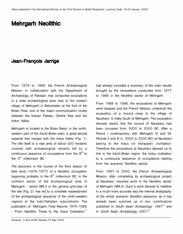
Mehrgarh NeolithicMehrgarh NeolithicMehrgarh NeolithicMehrgarh NeolithicMehrgarh Neolithic
Jean-Fran¸ois JarrigeJean-Fran¸ois JarrigeJean-Fran¸ois JarrigeJean-Fran¸ois JarrigeJean-Fran¸ois Jarrige
From 1975 to 1985, the French Archaeological
Mission, in collaboration with the Department of
Archaeology of Pakistan, has conducted excavations
in a wide archaeological area near to the modern
village of Mehrgarh in Balochistan at the foot of the
Bolan Pass, one of the major communication routes
between the Iranian Plateau, Central Asia and the
Indus Valley.
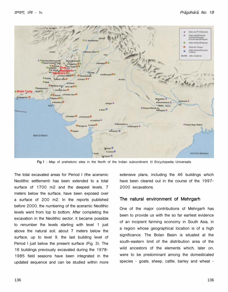
Mehrgarh is located in the Bolan Basin, in the north-
western part of the Kachi-Bolan plain, a great alluvial
expanse that merges with the Indus Valley (Fig. 1).
The site itself is a vast area of about 300 hectares
covered with archaeological remains left by a
continuous sequence of occupations from the 8th to
the 3rd millennium BC.
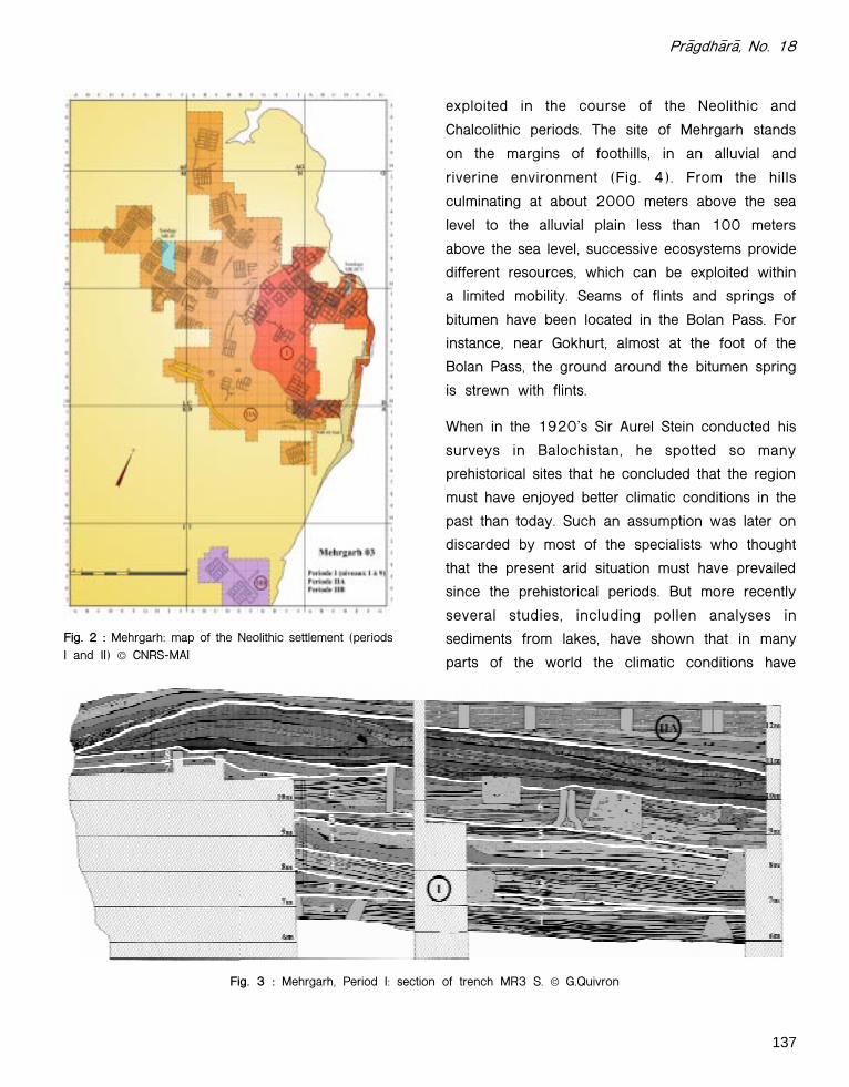
The discovery in the course of the third season of
field work (1976-1977) of a Neolithic occupation
beginning probably in the 8th millennium BC, in the
northern sector of the archaeological area of
Mehrgarh - sector MR.3 in the general grid-plan of
the site (Fig. 2), has led to a complete reassessment
of the archaeological sequence of the north-western
regions of the Indo-Pakistani subcontinent. The
publication of ""Mehrgarh, Field Reports 1974-1985
- From Neolithic Times to the Indus Civilization''1
had already provided a summary of the main results
brought by the excavations conducted from 1977
to 1985 in the Neolithic sector of Mehrgarh.
From 1985 to 1996, the excavations at Mehrgarh
were stopped and the French Mission undertook the
excavation of a mound close to the village of
Nausharo, 6 miles South of Mehrgarh. This excavation
showed clearly that the mound of Nausharo had
been occupied from 3000 to 2000 BC. After a
Period I contemporary with Mehrgarh VI and VII,
Periods II and III (c. 2500 to 2000 BC) at Nausharo
belong to the Indus (or Harappan) civilisation.
Therefore the excavations at Nausharo allowed us to
link in the Kachi-Bolan region, the Indus civilisation
to a continuous sequence of occupations starting
from the aceramic Neolithic period.
From 1997 to 2000, the French Archaeological
Mission, after completing its archaeological project
at Nausharo, resumed work in the Neolithic sector
of Mehrgarh (MR.3). Such a work allowed to redefine
in a much more accurate way the internal stratigraphy
of the whole aceramic Neolithic sequence, as it has
already been summed up in two contributions
published in South Asian Archaeology 1997 2 and
in South Asian Archaeology 2001.3
Paper presented in the International Seminar on the "First Farmers in Global Perspective', Lucknow, India, 18-20 January, 2006
Received: 9 April 2008; Revised: 07 May 2008
136
izkX/kkjk] vad & 18
The total excavated areas for Period I (the aceramic
Neolithic settlement) has been extended to a total
surface of 1700 m2 and the deepest levels, 7
meters below the surface, have been exposed over
a surface of 200 m2. In the reports published
before 2000, the numbering of the aceramic Neolithic
levels went from top to bottom. After completing the
excavation in the Neolithic sector, it became possible
to renumber the levels starting with level 1 just
above the natural soil, about 7 meters below the
surface, up to level 9, the last building level of
Period I just below the present surface (Fig. 3). The
16 buildings previously excavated during the 1978-
1985 field seasons have been integrated in the
updated sequence and can be studied within more
extensive plans, including the 46 buildings which
have been cleared out in the course of the 1997-
2000 excavations.
The natural environment of Mehrgarh
One of the major contributions of Mehrgarh has
been to provide us with the so far earliest evidence
of an incipient farming economy in South Asia, in
a region whose geographical location is of a high
significance. The Bolan Basin is situated at the
south-eastern limit of the distribution area of the
wild ancestors of the elements which, later on,
were to be predominant among the domesticated
species - goats, sheep, cattle, barley and wheat -
136
Pr¢gdh¢r¢, No. 18
Fig.1 : Map of prehistoric sites in the North of the Indian subcontinent. © Encyclopedia Universalis
137
Pr¢gdh¢r¢, No. 18
Fig. 3 : Mehrgarh, Period I: section of trench MR3 S. © G.Quivron
Fig. 2 : Mehrgarh: map of the Neolithic settlement (periodsI and II) © CNRS-MAI
exploited in the course of the Neolithic and
Chalcolithic periods. The site of Mehrgarh stands
on the margins of foothills, in an alluvial and
riverine environment (Fig. 4). From the hills
culminating at about 2000 meters above the sea
level to the alluvial plain less than 100 meters
above the sea level, successive ecosystems provide
different resources, which can be exploited within
a limited mobility. Seams of flints and springs of
bitumen have been located in the Bolan Pass. For
instance, near Gokhurt, almost at the foot of the
Bolan Pass, the ground around the bitumen spring
is strewn with flints.
When in the 1920's Sir Aurel Stein conducted his
surveys in Balochistan, he spotted so many
prehistorical sites that he concluded that the region
must have enjoyed better climatic conditions in the
past than today. Such an assumption was later on
discarded by most of the specialists who thought
that the present arid situation must have prevailed
since the prehistorical periods. But more recently
several studies, including pollen analyses in
sediments from lakes, have shown that in many
parts of the world the climatic conditions have

138
izkX/kkjk] vad & 18
Fig. 5 : Trench MR3 S and L. Costantini collecting samples from the section. © C. Jarrige
Fig. 4 : The Brahui Range seen from the site of Mehrgarh. © C. Jarrige
been subjected to changes in the course of the
last 10.000 years. In the case of the Bolan area,
Lorenzo Costantini and Alessandro Lentini have
carried out palynological investigations at Mehrgarh
and at Nausharo. They collected samples fromseveral columns in the Neolithic deposits (Period I)(Fig. 5).
The preliminary results of their work have been
139
Pr¢gdh¢r¢, No. 18
published in a contribution for South Asian
Archaeology 1997. 4 Their conclusion is that ""in the
Mehrgarh pollen record there is a great deal of
evidence which might be interpreted as relevant
data for wetter environmental conditions.'' The results
of the pollen analysis show that, from the beginning
of the Mehrgarh occupation till the 4th millennium
BC, "" the region was probably dominated by a semi-
lacustrine or humid environment with a riparian
vegetation, characterized by Populus, Salix, Fraxinus,
Ulmus and Vitis, associated in a typical hydrophitic
complex, arranged in dense gallery forests.''
For the time being, other pollen records from
Balochistan or from the Indus valley are lacking.
Nevertheless, the evidence from Mehrgarh is, to
some extent, consistent with the Holocene
environmental changes noticed in the sediments from
the Lunkaransar, Didwana and Sambhar paleolakes
in the Thar Desert. Such lakes kept permanent water
from 10.000 to 4.800 BP, before desiccating when
the water table went down.5 We can recall here that
V.N. Misra assumed that the set up of a rather
dense network of Mesolithic settlements in North
India took place probably in a context marked by
wetter climatic conditions than today.6
The updated sequence of the Neolithicoccupation
In the earlier publications, the Neolithic sequencehad been divided in Period IA, Neolithic aceramic,followed by Period IB when the first coarse chaff-tempered ceramics began occurring, and then byPeriod IIA associated with an increasing use of thesame coarse ceramics. But the extension of theexcavations and of the different sections have clearlyshown that some of the buildings previously assigned
to Period IB belong to the final occupation of the
aceramic settlement and that pottery starts occurring
for the first time in Period IIA. This is the reason
why phases IA and IB have been suppressed and
the sequence of the aceramic mound simply renamed
Period I.
The formation of the mound and thelayout of the Neolithic settlement.
The aceramic deposits (Period I) are approximately
7 meters thick. They have been divided in 9 main
levels. Each level has its distinct internal stratigraphy
and an obvious variable length of time. But as a
whole, each of them is marked by a similar course
of main episodes starting first with the edification of
mudbrick houses. Such buildings often show
modifications in the course of time and there are
also cases of houses still being occupied when an
adjoining one was already abandoned. The next
stage evidenced in each of the 9 major episodes,
both in the northern and southern trenches, occurred
when another area was selected to build new houses.
While the abandoned buildings of the left over area
were collapsing, they were progressively filled up
with dump thrown by people living in another more
or less adjacent area. After a span of time difficult
to evaluate, burials were dug in the accumulating
waste mixed with the debris of the collapsing walls
of the abandoned houses. It has also been noticed
that in most cases the graves pits had not cut
through the walls of the ruined houses, therefore it
can be assessed that the crumbled upper parts of
the walls were still visible when the area was turned
out into a graveyard. After a time of unknown
duration, the burial activity, possibly due to the
density of graves, came to an end. Then, the former
graveyard became an open space until levelling
operations were carried out in preparation for the
edification of a new set of domestic dwellings. The
same process would occur again when, after possibly
140
izkX/kkjk] vad & 18
more than two generations, the inhabitants of the
area would decide to build their houses in a new
location. When the walls of the abandoned buildings
had crumbled down and were progressively buried
in dump and layers of mudbrick debris, the area
was again used as a graveyard, following the process
already described. It is difficult to assess the total
duration of Period I, but according to the number of
superimposed occupational levels and graveyards,
the formation of the mound could easily have lasted
for about a millennium.
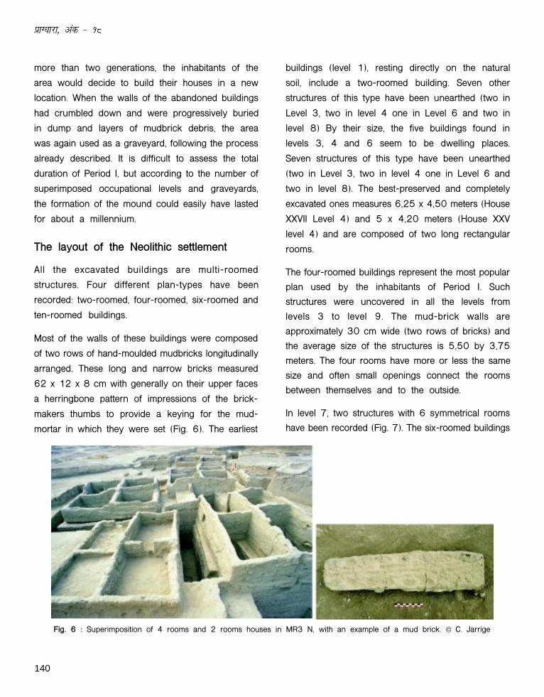
The layout of the Neolithic settlement
All the excavated buildings are multi-roomed
structures. Four different plan-types have been
recorded: two-roomed, four-roomed, six-roomed and
ten-roomed buildings.
Most of the walls of these buildings were composed
of two rows of hand-moulded mudbricks longitudinally
arranged. These long and narrow bricks measured
62 x 12 x 8 cm with generally on their upper faces
a herringbone pattern of impressions of the brick-
makers thumbs to provide a keying for the mud-
mortar in which they were set (Fig. 6). The earliest
buildings (level 1), resting directly on the natural
soil, include a two-roomed building. Seven other
structures of this type have been unearthed (two in
Level 3, two in level 4 one in Level 6 and two in
level 8) By their size, the five buildings found in
levels 3, 4 and 6 seem to be dwelling places.
Seven structures of this type have been unearthed
(two in Level 3, two in level 4 one in Level 6 and
two in level 8). The best-preserved and completely
excavated ones measures 6,25 x 4,50 meters (House
XXVII Level 4) and 5 x 4,20 meters (House XXV
level 4) and are composed of two long rectangular
rooms.
The four-roomed buildings represent the most popular
plan used by the inhabitants of Period I. Such
structures were uncovered in all the levels from
levels 3 to level 9. The mud-brick walls are
approximately 30 cm wide (two rows of bricks) and
the average size of the structures is 5,50 by 3,75
meters. The four rooms have more or less the same
size and often small openings connect the rooms
between themselves and to the outside.
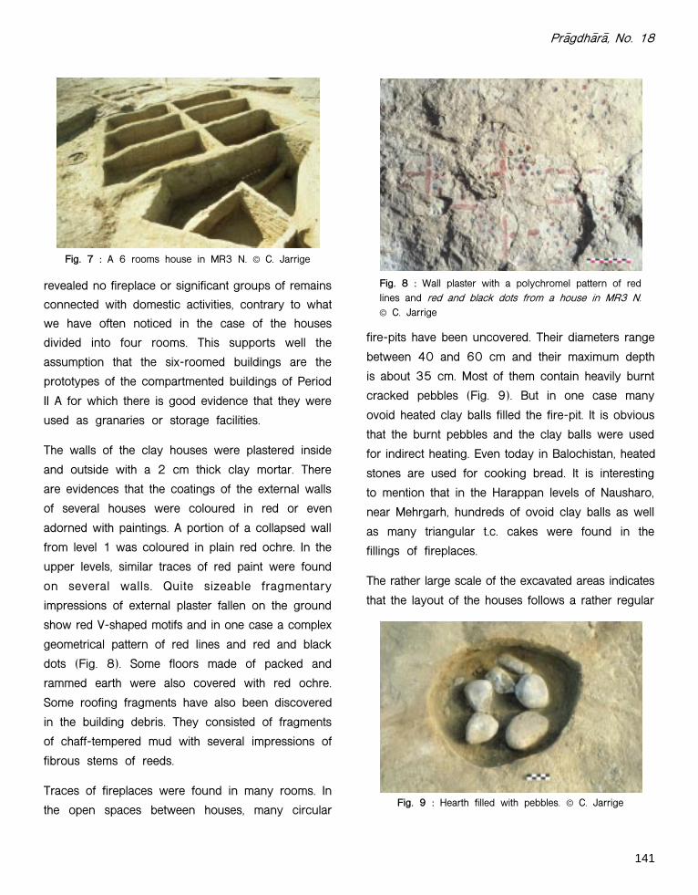
In level 7, two structures with 6 symmetrical rooms
have been recorded (Fig. 7). The six-roomed buildings
Fig. 6 : Superimposition of 4 rooms and 2 rooms houses in MR3 N, with an example of a mud brick. © C. Jarrige
141
Pr¢gdh¢r¢, No. 18
revealed no fireplace or significant groups of remains
connected with domestic activities, contrary to what
we have often noticed in the case of the houses
divided into four rooms. This supports well the
assumption that the six-roomed buildings are the
prototypes of the compartmented buildings of Period
II A for which there is good evidence that they were
used as granaries or storage facilities.
The walls of the clay houses were plastered inside
and outside with a 2 cm thick clay mortar. There
are evidences that the coatings of the external walls
of several houses were coloured in red or even
adorned with paintings. A portion of a collapsed wall
from level 1 was coloured in plain red ochre. In the
upper levels, similar traces of red paint were found
on several walls. Quite sizeable fragmentary
impressions of external plaster fallen on the ground
show red V-shaped motifs and in one case a complex
geometrical pattern of red lines and red and black
dots (Fig. 8). Some floors made of packed and
rammed earth were also covered with red ochre.
Some roofing fragments have also been discovered
in the building debris. They consisted of fragments
of chaff-tempered mud with several impressions of
fibrous stems of reeds.
Traces of fireplaces were found in many rooms. In
the open spaces between houses, many circular
fire-pits have been uncovered. Their diameters range
between 40 and 60 cm and their maximum depth
is about 35 cm. Most of them contain heavily burnt
cracked pebbles (Fig. 9). But in one case many
ovoid heated clay balls filled the fire-pit. It is obvious
that the burnt pebbles and the clay balls were used
for indirect heating. Even today in Balochistan, heated
stones are used for cooking bread. It is interesting
to mention that in the Harappan levels of Nausharo,
near Mehrgarh, hundreds of ovoid clay balls as well
as many triangular t.c. cakes were found in the
fillings of fireplaces.
The rather large scale of the excavated areas indicates
that the layout of the houses follows a rather regular
Fig. 7 : A 6 rooms house in MR3 N. © C. Jarrige
Fig. 8 : Wall plaster with a polychromel pattern of redlines and red and black dots from a house in MR3 N.© C. Jarrige
Fig. 9 : Hearth filled with pebbles. © C. Jarrige

142
izkX/kkjk] vad & 18
Fig. 10 : Period I: Imprints of barley (Hordeum vulgare)(L) and wheat (Triticum dicoccum) (R). © L. Costantini
pattern. They are divided into two groups, one
having its main axe East-West oriented and the
other North-South. Between houses, open spaces
allowed an easy circulation. This layout with its
symmetrically disposed houses, with rather regular
open spaces in-between, forms a marked contrast
with the plans of several Neolithic settlements from
Western and Central Asia, where the houses cluster
tightly together and where there is no evidence for
alleys, doorways or large open spaces. The plans of
the houses from early villages so far recorded in the
Neolithic of Western or Central Asia often show
rather irregular combinations of small cubicles of
various sizes.
The subsistence pattern
Though the exact dating of the beginning of thesettlement is still difficult to assess, we can say thatthe first levels of the Neolithic period at Mehrgarhprovides us, as early as the 8th millennium BC, withthe first evidence of the progressive setting of afarming economy in the north-western part of theIndo-Pakistani subcontinent.
Lorenzo Costantini has shown that the plantassemblage of Period I is dominated by naked six-
row barley which accounts for more than 90% of
the so far recorded seeds and imprints.7 He has
also pointed out the sphaerococcoid form of the
naked-barley grains with a short compact spike with
shortened internodes and small rounded seeds.
According to him, such characteristics in the aceramic
Neolithic levels can be ascribed to probably cultivated
but perhaps not fully domesticated plants. Domestic
hulled six-row barley (H. vulgare, subsp. vulgare)
and wild and domestic hulled two-row barley (H.
vulgare subsp. spontaneum and H. vulgare subsp.
distichum) have also been recorded, but in much
smaller quantities. According to Zohary8 quoted by
R.H. Meadow,9 the distribution of wild barley extends
today to the head of the Bolan Pass. It is therefore
likely that local wild barleys could have been brought
under cultivation in the Mehrgarh area. Costantini
has also identified a small amount of domestic
einkorn (hulled: Triticum monococcum), domestic
emmer (hulled: T. turgidum subsp. dicoccum) and a
free-threshing form which can be referred to as
Triticum durum (Fig. 10). So far no morphological
wild wheat has been identified in South Asia.
Therefore the small amount of wheat seeds at
Mehrgarh, Period I, needs further explanation since
obviously wheat has not a great significance in the
agricultural activities of the aceramic period.
143
Pr¢gdh¢r¢, No. 18
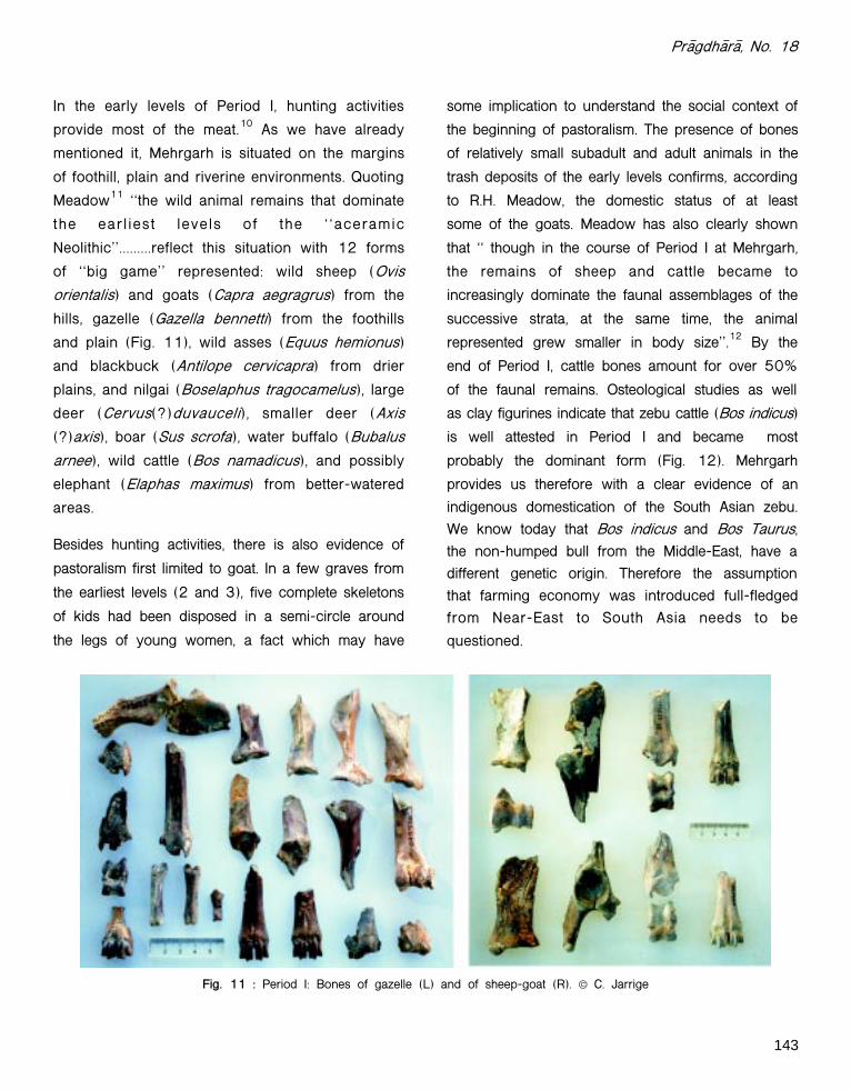
Fig. 11 : Period I: Bones of gazelle (L) and of sheep-goat (R). © C. Jarrige
In the early levels of Period I, hunting activities
provide most of the meat.10 As we have already
mentioned it, Mehrgarh is situated on the margins
of foothill, plain and riverine environments. Quoting
Meadow11 ""the wild animal remains that dominate
the ear l iest levels of the " "aceramic
Neolithic''.........reflect this situation with 12 forms
of ""big game'' represented: wild sheep (Ovis
orientalis) and goats (Capra aegragrus) from the
hills, gazelle (Gazella bennetti) from the foothills
and plain (Fig. 11), wild asses (Equus hemionus)
and blackbuck (Antilope cervicapra) from drier
plains, and nilgai (Boselaphus tragocamelus), large
deer (Cervus(?)duvauceli), smaller deer (Axis
(?)axis), boar (Sus scrofa), water buffalo (Bubalus
arnee), wild cattle (Bos namadicus), and possibly
elephant (Elaphas maximus) from better-watered
areas.
Besides hunting activities, there is also evidence of
pastoralism first limited to goat. In a few graves from
the earliest levels (2 and 3), five complete skeletons
of kids had been disposed in a semi-circle around
the legs of young women, a fact which may have
some implication to understand the social context of
the beginning of pastoralism. The presence of bones
of relatively small subadult and adult animals in the
trash deposits of the early levels confirms, according
to R.H. Meadow, the domestic status of at least
some of the goats. Meadow has also clearly shown
that "" though in the course of Period I at Mehrgarh,
the remains of sheep and cattle became to
increasingly dominate the faunal assemblages of the
successive strata, at the same time, the animal
represented grew smaller in body size''.12 By the
end of Period I, cattle bones amount for over 50%
of the faunal remains. Osteological studies as well
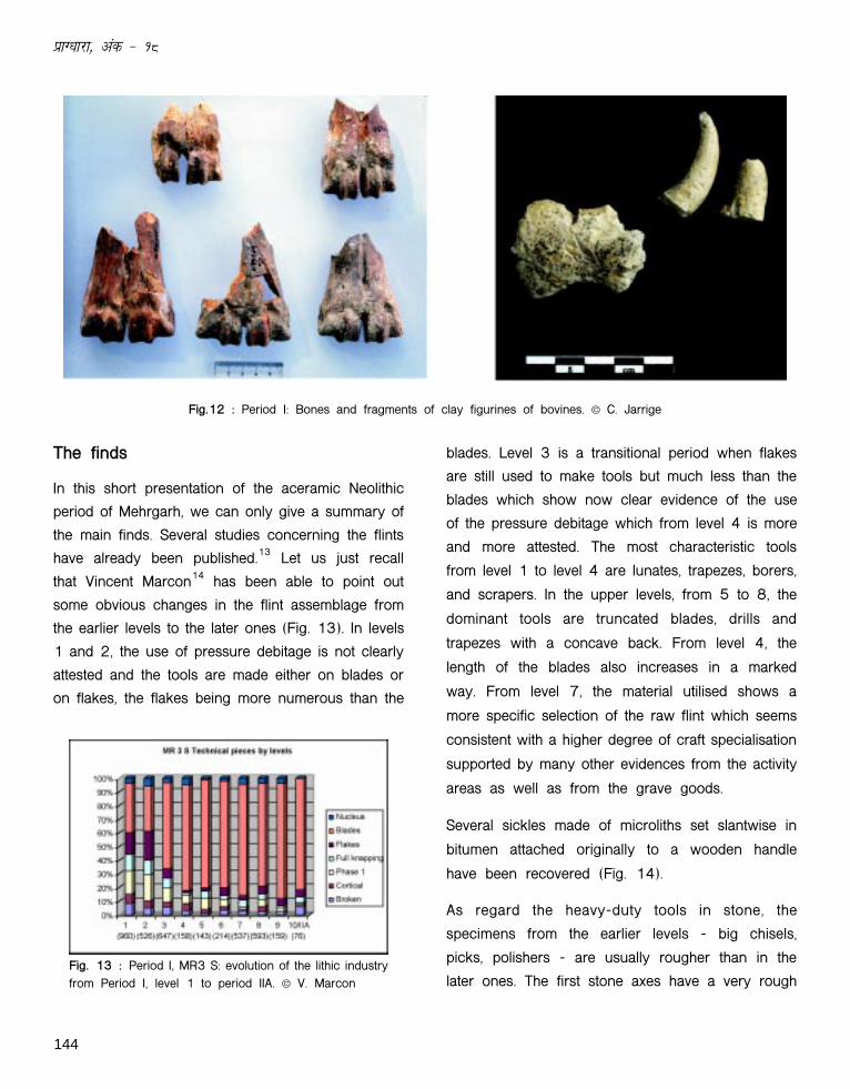
as clay figurines indicate that zebu cattle (Bos indicus)
is well attested in Period I and became most
probably the dominant form (Fig. 12). Mehrgarh
provides us therefore with a clear evidence of an
indigenous domestication of the South Asian zebu.We know today that Bos indicus and Bos Taurus,the non-humped bull from the Middle-East, have adifferent genetic origin. Therefore the assumptionthat farming economy was introduced full-fledgedfrom Near-East to South Asia needs to be
questioned.
144
izkX/kkjk] vad & 18
Fig. 13 : Period I, MR3 S: evolution of the lithic industryfrom Period I, level 1 to period IIA. © V. Marcon
The finds
In this short presentation of the aceramic Neolithic
period of Mehrgarh, we can only give a summary of
the main finds. Several studies concerning the flints
have already been published.13 Let us just recall
that Vincent Marcon14 has been able to point out
some obvious changes in the flint assemblage from
the earlier levels to the later ones (Fig. 13). In levels
1 and 2, the use of pressure debitage is not clearly
attested and the tools are made either on blades or
on flakes, the flakes being more numerous than the
blades. Level 3 is a transitional period when flakes
are still used to make tools but much less than the
blades which show now clear evidence of the use
of the pressure debitage which from level 4 is more
and more attested. The most characteristic tools
from level 1 to level 4 are lunates, trapezes, borers,
and scrapers. In the upper levels, from 5 to 8, the
dominant tools are truncated blades, drills and
trapezes with a concave back. From level 4, the
length of the blades also increases in a marked
way. From level 7, the material utilised shows a
more specific selection of the raw flint which seems
consistent with a higher degree of craft specialisation
supported by many other evidences from the activity
areas as well as from the grave goods.
Several sickles made of microliths set slantwise in
bitumen attached originally to a wooden handle
have been recovered (Fig. 14).
As regard the heavy-duty tools in stone, the
specimens from the earlier levels - big chisels,
picks, polishers - are usually rougher than in the
later ones. The first stone axes have a very rough
Fig.12 : Period I: Bones and fragments of clay figurines of bovines. © C. Jarrige
145
Pr¢gdh¢r¢, No. 18
an early context and also the use of resources from
often far away regions.
The graveyards
Alternating with the nine building levels, nine levels
of graveyards have been recorded. A total of 318
graves have been exposed, among which, from level
1 to level 9, 179 have yielded gravegoods. At the
bottom of an about 1 m deep pit, a small space dug
on one side of the pit was used as a small burial
chamber. Then the burial chamber was, after disposal
of the dead body always in flexed position, blocked
by packs of hard clay or by brick walls, and the pit
was filled with earth. More than 75% of the graves
have an East-West orientation. The heads are in
many cases looking toward South, but also towards
East and more seldom towards North. Other graves
are mostly oriented North- South.
The most characteristic graves from the lower levels
are single pits or tombs with a funerary chamber in
which the dead was placed along with offerings of
young goats disposed in a semi-circle around the
legs (Fig. 17). The existence of funerary chambers
during this earlier period was provided for the first
time by several graves partly cut by the section wall
Fig. 15 : Period I: Polished stone axes. © C. Jarrige
Fig. 14 : Period I: flint microliths set in bitumen. © C.Jarrige
picked surface and it is only in a later stage (level 7)
that the axes are polished, the finer examples coming
from the graves of Cemeteries 8 and 9 (Fig. 15).
The remains of several workshops of beadmakers
with beads in calcite or steatite in various stages of
processing have been found in different levels (Fig.
16). The gravegoods have also provided us with a
rich corpus of information about the craft activities
in the course of the aceramic Neolithic period of
Mehrgarh. They include a wide range of ornaments
made predominantly of seashells, but also of lapis
lazuli, turquoise, black steatite and several other
stones. The quality of such ornaments implies a
level of specialisation that was not expected in such
Fig. 16 : Period I: remains of a steatite beads workshopshowing stages of manufacture. © C. Jarrige

146
izkX/kkjk] vad & 18
of the MR3 South trench. A thin layer of red ochre
was found, just below the dead and the baby goats,
on the floor of the funerary chamber which was
closed by a small wall made of seven courses of
mud bricks. A young female buried in tomb 276
was wearing a necklace made of seashells and
lined up vertebras from the tail of a bovine were
near the bones of the hand. The tail may have been
used originally as a flyswatter. The four young goats
also placed along with the dead at the time of the
inhumation are worthy of mention.
In level 3, two young female were buried with five
young goats; one of them was wearing ornaments in
lapis lazuli, turquoise and seashells and two anklets
in calcite. In many cases, the intermediate graveyards
are characterized by the diversity and by the richness
of the ornaments placed with the dead at the time of
the inhumation. Exceptional grave deposits are
dentalium headbands found on the heads of several
females like for example in Tomb 573. In Burial 274
(Fig. 18) the headband was made up of woven rows
of small dentalium segments and was closed by two
straps used as a clasp. Each of them was ornamented
with four perforated natural shells. Around the neck
was a thin necklace made of shell beads and at the
waist, a belt-like ornament was made up of cylindrical
shell beads and of one flattened polyhedral shell
bead. Hanging on the belt, an interlacing of numerous
threaded dentalium beads was found in front of the
pelvis of the individual.
Fig. 17 : Period I: Graves with young goats associated with the skeletons of young women. © C. Jarrige

147
Pr¢gdh¢r¢, No. 18
Fig.18 : Headband and waist ornament in Grave 274 (cemetery 5). © C. Jarrige
Fig. 19 : Grave 281 (cemetery 4) and detail of headband. © C. Jarrige
In Burial 281 the headband is even more spectacular.
The numerous dentalium segments have been woven
in a netting way (Fig. 19).
A belt-like ornament was also uncovered around
the waist of a male in Tomb 279. It consisted of
23 long cylindrical shell beads and of a lozenge-
shaped mother-of-pearl pendant. Another most
spectacular discovery in this grave was a rather
large rounded lapis lazuli bead found near the chin
of the decease.
A very young child was also uncovered adorned
with necklaces made up of dentalium shell and
steatite beads as well as anklets in polyhedral shell
beads. Two heaps of red ochre were placed on
each side of the skull in Tomb 578. The large size
of the ornaments indicates that originally they
148
izkX/kkjk] vad & 18
belonged to an adult. They had not been put aroundthe limbs of the small deceased but simply disposedon his body. Another infant in Tomb 508 was alsorichly adorned with numerous ornaments with beadsmade of diversified material including red stone.
The structures of the graves from this phase are ofthe usual type with a funerary chamber closed eitherby a small wall made of long bricks laid in alternateheaders and stretchers or with fragments of mudbricksput in the grave so as to fill about half the pit.
In the upper graveyards, the funerary chambers of
the tombs are still blocked up by a small mudbrick
wall and the dead bodies are very often associated
with numerous grave-goods and ornaments. In Tomb
234, an adult was buried with a display of stone
and bone tools carefully placed in one of his hands
and probably linked to the activity of the deceased
during his lifetime. A very interesting cluster of tools
and ornaments made of bone as well as a small
piece of galena was uncovered in the burial chamber
of another female adult (Tomb 290).
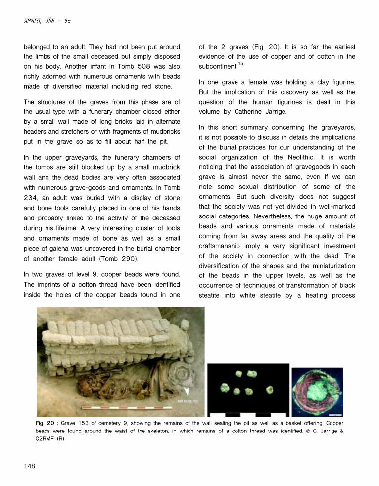
In two graves of level 9, copper beads were found.
The imprints of a cotton thread have been identified
inside the holes of the copper beads found in one
of the 2 graves (Fig. 20). It is so far the earliestevidence of the use of copper and of cotton in thesubcontinent.15
In one grave a female was holding a clay figurine.But the implication of this discovery as well as thequestion of the human figurines is dealt in thisvolume by Catherine Jarrige.
In this short summary concerning the graveyards,it is not possible to discuss in details the implicationsof the burial practices for our understanding of thesocial organization of the Neolithic. It is worthnoticing that the association of gravegoods in eachgrave is almost never the same, even if we cannote some sexual distribution of some of theornaments. But such diversity does not suggestthat the society was not yet divided in well-markedsocial categories. Nevertheless, the huge amount ofbeads and various ornaments made of materialscoming from far away areas and the quality of thecraftsmanship imply a very significant investmentof the society in connection with the dead. Thediversification of the shapes and the miniaturizationof the beads in the upper levels, as well as theoccurrence of techniques of transformation of blacksteatite into white steatite by a heating process
Fig. 20 : Grave 153 of cemetery 9, showing the remains of the wall sealing the pit as well as a basket offering. Copperbeads were found around the waist of the skeleton, in which remains of a cotton thread was identified. © C. Jarrige &C2RMF (R)

149
Pr¢gdh¢r¢, No. 18
reveal an increasing level of craft specialization.The production of white steatite beads in the finalphase of the aceramic Neolithic marks the beginningof a local craft tradition which will lead to theproduction of glazed white steatite beads in thecourse of Period III at Mehrgarh, in the last part ofthe 5th millennium BC.16
The anthropological project conducted by severalItalian colleagues has already provided major results,which cannot be detailed here.17 Let us just mentionthe fact that the average stature of the males wasabout 170 cm and 160 cm for the females,though among the female individuals, several werecharacterized by tall stature, some of them as tallas 175 cm. This may be an indicator of overallgood health, good diet and low exposure todevelopmental stress.18 The Neolithic graveyardsprovide us also with the earliest evidence of dentistryin the archaeological records. Eleven drilled molarcrowns from nine individuals (four females, twomales and three unidentified) have been recorded.One individual has three drilled teeth, another onehas the same tooth drilled twice. Experimentationshows that a bow-drill tipped with a flint headrequired less than a minute to produce such holes
in human enamel.19
The end of Period I
The last episode of burials, cemetery 9, of Period Itook place when the mound formed by theaccumulated remains of successive occupations hadbeen deserted by its inhabitants. The positions ofsome of the graves on the already eroded slopes ofthe Neolithic mound, and of several others, whichwere obviously dug on an uneven surface whereruins formed small hillocks, indicate that there wasa rather long span of time between the last level ofoccupation (level 9) and the setting of the lastgraveyard (cemetery 9) of the same Period I. The
Fig. 21 : Period IIA: fragments of a large fired containerassembled with the technique of "sequential slabconstruction". © C. Jarrige
abandonment of the Period I mound corresponds toa period of alluvial terrace formation. In the profilesof the sections throughout the Period I mound, onecan see clearly successive alluvial strata that cameto rest at a slant against the sides of the mound.This rather impressive alluvial process marked byseveral episodes has slowly buried the mound andraised by several meters the level of the surroundingplain before the inhabitants of the following Period
IIA began to build their settlement.
Period IIA.
This contribution is limited to the aceramic Neolithicof Mehrgarh. Let us just recall that probably around6000 BC, crudely made potsherds with a heavyshaff temper are found in a limited quantity. InPeriod I, the containers so far recorded were basketscoated with bitumen. A few stone vessels have alsobeen found in the last stage of Period I, mostly inlevels 8 and 9. In Period IIA the pots, mostly bowlsand basins, are constructed by assembling pieces ofclay, the sequential slab construction well attestedat several Near-Eastern sites at about 6000 BC20
(Fig. 21).
150
izkX/kkjk] vad & 18
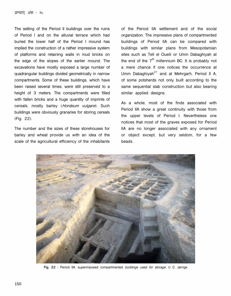
The setting of the Period II buildings over the ruins
of Period I and on the alluvial terrace which had
buried the lower half of the Period I mound has
implied the construction of a rather impressive system
of platforms and retaining walls in mud bricks on
the edge of the slopes of the earlier mound. The
excavations have mostly exposed a large number of
quadrangular buildings divided geometrically in narrow
compartments. Some of these buildings, which have
been raised several times, were still preserved to a
height of 3 meters. The compartments were filled
with fallen bricks and a huge quantity of imprints of
cereals, mostly barley (Hordeum vulgare). Such
buildings were obviously granaries for storing cereals
(Fig. 22).
The number and the sizes of these storehouses for
barley and wheat provide us with an idea of the
scale of the agricultural efficiency of the inhabitants
of the Period IIA settlement and of the social
organization. The impressive plans of compartmented
buildings of Period IIA can be compared with
buildings with similar plans from Mesopotamian
sites such as Tell el Oueili or Umm Dabaghiyah at
the end of the 7th millennium BC. It is probably not
a mere chance if one notices the occurrence at
Umm Dabaghiyah21 and at Mehrgarh, Period II A,
of some potsherds not only built according to the
same sequential slab construction but also bearing
similar applied designs.
As a whole, most of the finds associated with
Period IIA show a great continuity with those from
the upper levels of Period I. Nevertheless one
notices that most of the graves exposed for Period
IIA are no longer associated with any ornament
or object except, but very seldom, for a few
beads.
Fig. 22 : Period IIA: superimposed compartmented buildings used for storage. © C. Jarrige
151
Pr¢gdh¢r¢, No. 18
The nature of the Neolithic settlements ofMehrgarh
Traditionally the early Neolithic sites are considered
as small villages, with a limited number of inhabitants.
The scale of the excavations conducted in the
Neolithic sector of Mehrgarh provides us only with
a partial view of the Neolithic settlement. But there
are enough indications to assess that the aceramic
settlement cannot be defined as a small village. It
has already been mentioned that the Bolan river has
cut a wide portion of the settlement. By doing so the
river has also provided us with a complete profile of
the Neolithic settlements, showing, on each side of
the central core made of the ruins of accumulated
buildings, wide expanses of archaeological deposits
with fire-places and fire-pits, associated with burnt
pebbles and grinding stones over an estimated
surface of 15 hectares. For the following period
(Period II) the total area of archaeological remains
must have originally covered about 45 hectares.
The dating
In some of our previous publications we have already
pointed out that several radiocarbon dates were not
in accordance with the stratigraphy of the site.22 But
we have also indicated that, for Period I, a series of
dates are as early as 7928+/173 BP, 9385+/120
BP, 7115+/290 BP, 8440+/250 BP. Such dates
when calibrated are therefore for some of them well
before 7000 BC or for some others around 7000
BC. For Period IIB, the late Neolithic period associated
with a fine lustrous red pottery, we have a date of
7115+/120 BP (c. 6000-5800 BC) and for Period
III, the early Chalcolithic, our only date is 6900 BP
(c. 5300 BC). As regard the other samples which,
as we already said it, have provided erratic datings,
it should be recalled that the studies of the sections
have shown that the Neolithic deposits have been
flooded many times and were, until recently, buried
under a dense network of irrigated fields used also
as grazing lands. From top to bottom the
archaeological deposits revealed the existence of a
very dense and ancient network of more or less
fossilized roots as well as holes and galleries made
by rodents and insects. Such dense circulations of
organic matters throughout the deposits in the
course of several millennia have to be kept into
account to explain some of the discrepancies
between dates from samples often collected in the
same level. Though it is difficult to date precisely
the beginning of Period I, it can be rather securely
assessed that the first occupation of Mehrgarh has
to be put in a context probably earlier than 7000 BC.
Conclusion
In spite of some obvious differences, for instance
the progressive predominance of the breeding of
zebu (Bos indicus), the full setting of farming economy
at Mehrgarh displays evident similarities with what
had been noticed in the case of the early Neolithic
settlements in the hilly regions forming the eastern
border of Mesopotamia. The circular houses of the
earliest Neolithic villages have not been found at
Mehrgarh. But quadrangular houses built with about
60 cm long narrow bricks with a herringbone pattern
of impressions of thumbs to provide a keying for the
mud-mortar, have been uncovered at several aceramic
Neolithic sites in the Zagros, such as Ganj Dareh or
Ali Kosh in the Deh Luran region of Iran, where, like
at Mehrgarh, traces of red paint have also been
noticed on the walls. Circular fire-pits filled with
burnt pebbles are also associated to all these early
settlements. The lithic industries also show evident
parallels, which cannot be developed in this
152
izkX/kkjk] vad & 18
contribution. Nevertheless it can be pointed out that
the polished-stone axes begin occurring at several
sites of the Deh Luran area, such as Ali Kosh, only
in the later phases of the aceramic Neolithic along
with an increasing number of stone vessels.23 It is
the same at Mehrgarh where the polished stone
axes in black diorite are found only in the upper
levels of Period I, mostly as gravegoods. From
Period II at Mehrgarh, the polished or ground stones
are no longer found in the Kachi-Bolan area and
elsewhere in Balochistan.
No graveyards have been exposed on a large scale
like at Mehrgarh, either in the Zagros or Del Luran
area, making comparison difficult. But, for instance,
the few graves exposed at Ali Kosh show skeletons
with positions rather similar to those of Mehrgarh.
Among the gravegoods one notices ornaments made
of seashells and semi-precious stones such as
turquoise, a few beads in copper. Baskets coated
with bitumen and oblong-shaped cakes of red-ochre
strengthen the parallels. Catherine Jarrige in her
contribution has also dealt with the similarities
between certain types of figurines. We have also
seen the strong parallels between the first occurrence
of ceramics built according to the same sequential
slab construction and the setting of big multi-cellular
granaries at Mehrgarh at the beginning of Period II
and at several sites in Mesopotamia, among which
Umm Dabaghiyah before and around 6000 BC.
The similarities noticed between Neolithic sites from
the eastern border of Mesopotamia to the western
margins of the Indus valley are highly significant. A
sort of cultural continuum between sites sharing a
rather similar geographical context marked with an
also rather similar pattern of evolution and
transformation becomes more and more evident. But
the Neolithic of Mehrgarh displays enough original
features to imply an earlier local background which
has so far not been documented. Nevertheless the
cultural dynamism shown by the inhabitants of
Mehrgarh as early as level I of Period I indicate that
the Neolithic of Balochistan cannot be interpreted as
the ""backwater'' of the Neolithic culture of the Near-
East.
One of the major contributions of Mehrgarh is to
indicate clearly the existence of a very impressive
Neolithic background as early as the 8th millennium
BC in the north-western regions of the Indo-Pakistani
subcontinent. Further East, we progressively enter
other geographical contexts, in particular those
affected by the monsoon. As early as 1867, A.C.L.
Carlyle, of the Archaeological Survey of India,
discovered in Uttar Pradesh and in Madhya Pradesh
(dist. Mirzapur and Rewa) many sites with microliths
and rock shelters, some decorated with paintings.
Since then, thousands of ""Mesolithic'' sites have
been recorded as well as many ""Neolithic'' settlements
close to lakes left by ancient meanders of the
Ganges, in areas of distribution of wild cereals such
as rice. Several contributions published in this volume
attest of the dynamism of archaeological research
related to the Mesolithic and Neolithic horizons of
regions belonging to the Ganges system. As well as
for Mehrgarh, there are sometimes some problems
with the radiocarbon dates from such sites, but
there is no reason to discard systematically early
datings. Let us recall that, before the discovery of
Mehrgarh, the first settlements in Balochistan and
the Indus valley were thought not to be earlier than
4000 BC and were interpreted as the result of an
eastern diffusion of an Iranian or Central Asia model.
Therefore the Mesolithic and Neolithic sites of the
Ganga system with their specific aspects such as
the availability of wild rice were often studied within
153
Pr¢gdh¢r¢, No. 18
a purely ""Indian'' context. But we have now evidence
that, in the north-western part of the subcontinent,
communities were involved as early as the 8th
millennium BC in more or less incipient farming
activities, based on the domestication of cereals
such as barley and of local wild animals.
This conference held in Lucknow on the ""first
farmers'' at the instigation of Dr. Rakesh Tewari is
very important in promoting a more global approach
of the archaeology of the whole subcontinent.
Ongoing work in Uttar Pradesh, in particular at
Lahuradewa providing early evidence of rice
exploitation, and at several other sites expanding to
the North of the Vindhya hills, has greatly extended
our knowledge of the early more or less incipient
farming communities of the Middle Ganga Plain.24
Due to the data collected in the course of the last
twenty years, our analyses of the Neolithic settlements
of the Greater Indus system, as well as the Mesolithicand Neolithic sites of the Greater Ganga system, willprovide a more comprehensive understanding of theinteraction between groups of hunter-gatherers,incipient farmers or early farmers all over the northernpart of the subcontinent from Balochistan to the
Middle Ganga Plain.
References
1. Jarrige, C., Jarrige J.-F., Meadow R.H. & Quivron, G.(eds.) 1995. Mehrgarh Field Reports 1974-1985. From Neolithic Times to the IndusCivilization. Karachi: The Department of Cultureand Tourism, Government of Sindh.
2. Jarrige, J.-F. 2000. "Mehrgarh Neolithic: NewExcavations', in M. Taddei & G. De Marco(eds.) South Asian Archaeology 1997, pp.259-283. Rome: IsIAO.
3. Jarrige, J.-F., Jarrige, C. & Quivron, G. 2005."Mehrgarh Neolithic: the updated sequence', inC. Jarrige & V. Lefèvre (eds.) South AsianArchaeology 2001, vol. 1, pp. 129-141. Paris:ERC.
4. Costantini, L. & Lentini, A. 2000. "Studies in theVegetation History of Central Baluchistan,Pakistan: Palynological Investigations of aNeolithic Sequence at Mehrgarh', in M. Taddei& G. De Marco (eds.) South Asian Archaeology1997, pp. 133-159. Rome: IsIAO.
5. Enzeel, Y., Ely, L.L., Mishra, S., Ramesh, R.,Arnit, R., Lazar, B., Rajaguru, S.N., Baker,V.R. & Sandler, A. 1999. "High-ResolutionHolocene Environmental Changes in the TharDesert, Northwestern India', Science 284 :125-128.
6. Misra, V.N. 2002. "The Mesolithic Age in India', inS. Settar & R. Korisettar (eds.) IndianArchaeology in Retrospect, Prehistory:Archaeology of South Asia. I, pp. 111-125New Delhi: ICHR Manohar.
7. Costantini, L. 1984. "The Beginning of Agriculturein the Kachi Plain: the Evidence of Mehrgarh',in B. Allchin (ed.) South Asian Archaeology1981, pp. 29-33. Cambridge: CambridgeUniversity Press.
8. Zohary, D. 1989. "Domestication of Southwest AsianNeolithic Crop Assemblage of Cereals, Pulses,and Flax: The Evidence From the Living Plants',in D.R. Harris and G.C. Hillman (eds) Foragingand Farming : the Evolution of Plant Exploitation, pp. 358-373. London : Unwin Hyman.
9. Meadow, R.H. 1998. "Pre- and Proto-HistoricAgricultural and Pastoral Transformations inNorth-Western South Asia', in O. Bar-Yosef(ed.) The Review of Archaaeology (SpecialIssue) 19, 2: 12-21.
10. Meadow, R.H. 1981. "Early Animal Domesticationin South Asia: a First Report of the FaunalRemains from Mehrgarh, Pakistan', in H”rtel H.(ed.) South Asian Archaeology 1979, pp. 143-179. Berlin: Dietrich Reimer Verlag.

154
izkX/kkjk] vad & 18
Meadow, R.H. 1984. "Notes on the Faunal Remainsfrom Mehrgarh, with a focus on cattle (Bos)',in Allchin B. (ed.) South Asian Archaeology1981, pp. 34-40. Cambridge: CambridgeUniversity Press.
11. Meadow 1998. Op. cit. 16.
12. Ibid.
13. Marcon, V. & Lechevallier, M. 2000. "TechnologicalApproach of Blade Debitage in the Assemblagesof Mehrgarh-Nausharo and Miri Qalat inBalochistan, Pakistan', in M. Taddei & G. DeMarco (eds.) South Asian Archaeology 1997,pp. 215-235. Rome: IsIAO ;
Lechevallier, M. 2003. Le Mat˜riel lithique deMehrgarh-Nausharo: fouilles de 1975-1995.Paris: ERC.
14. Marcon, V. (n.d.) "Technical innovations andconceptual changes in the lithic debitage of theaceramic Neolithic of Mehrgarh (Baluchistan,Pakistan)', in E. M. Raven & G. L. Possehl (eds.)South Asian Archaeology 1999. Groningen.
15. Moulherat, C., Tengberg, M., Haquet, J.-F. & Mille,B. 2002. "First Evidence of Cotton at NeolithicMehrgarh, Pakistan: Analysis of MineralizedFibres from a Copper Bead', Journal ofArchaeological Science, 29 : 1393-1401.
16. Barth˜lemy de Saizieu, B. & Bouquillon, A. 1994."Steatite working at Mehrgarh during the Neolithicand Chalcolithic periods: quantitative distribution,characterization of material and manufacturingprocesses', in A. Parpola & P. Koskikallio (eds.)South Asian Archaeology 1993, I, pp. 47-59.Helsinki: Suomalainen Tiedeakatemia ;
Barth˜lemy de Saizieu, B. 2003. Les Parures deMehrgarh: Perles et Pendentifs du N˜olithique
pr˜c˜ramique ” la P˜riode pr˜-Indus. Paris:ERC.
17. Cucina, A. & Petrone, P.P. 2005. "The 1997-2000 Field Seasons at Mehrgarh: PreliminaryAnthropological and Taphonomic Evidence', inC. Jarrige & V. Lef˜vre (eds.) South AsianArchaeology 2001, vol.1, pp. 79-84. Paris:ERC.
18. Ibid. 83.
19. Coppa, A., Bondioli, L., Cucina, A., Frayer, D.W.,Jarrige, C., Jarrige, J.F., Quivron, G., Rossi, M.,Vidale, M. & Macchiarelli, R. 2006. "EarlyNeolithic tradition of dentistry', Nature, vol. 440 :755-756.
20. Vandiver, P. 1995. "The Production Technology ofEarly Pottery at Mehrgarh', C. Jarrige, J.-F.Jarrige, R. H. Meadow & G. Quivron (eds.)Mehrgarh Field Reports 1974-1985. Karachi:The Department of Culture and Tourism,Government of Sindh.
21. Kirkbride, D. 1972. "Umm Dabaghiyah, 1971: apreliminary report. An Early Ceramic FarmingSettlement in Marginal North Central Jazirah,Iraq, 34: 3-19
22. Jarrige 2000. Op. cit.
23. Hole, F., Flannery, K.V. & Nelly, J.A. 1969."Prehistory and Human Ecology of the DehLuran Plain', Memoirs of the Museum ofAnthropology no. 1. Ann Arbor.
24. Tewari, R., Srivastava, R.K., Singh, K.K.,Vinay, R.,Trivedi, R.K. & Singh, G.C. 2004-2005."Recently Excavated Sites in the Ganga Plainand North Vindhyas: Some ObservationsRegarding the Pre-urban Context'. Pr¢gdh¢r¢,Journal of the U.P. State ArchaeologyDepartment, Lucknow 15: 39-50.
Jean-Fran¸ois JarrigeCNRS-UMR 9993Mus˜e guimet19, av. d'lina75116 Paris, France