Embed Size (px)
Citation preview

FINAL TECHNICAL MEMORANDUM #10
City of Klamath Falls East Main Street Bypass Project
Functional Design Analysis
MEMORANDUM
Date: June 14, 2004 Project #: 5688.0
To: Mike Kuenzi, P.E. City of Klamath Falls
From: Marc A. Butorac, P.E.
Hermanus J. Steyn, Pr.Eng. Kevin S. Lee
cc: Russell C. Carter, Zbinden Carter Engineering, Inc.
Scott Souders, Zbinden Carter Engineering, Inc. Dianne Stockton, Shapiro & Associates, Inc. David Feinauer, Right-Of-Way Associates Inc.
INTRODUCTION
This memorandum describes the preliminary functional design for the East Main Street Bypass Project in the City of Klamath Falls, Oregon. As part of this technical memorandum, various considerations were incorporated within the functional designs. These considerations include:
• The necessary mitigations under 2023 traffic conditions with the construction of the bypass (Alternative #2 – excluding the SSSD property) as discussed in Memorandum #9B,
• The City of Klamath Falls standards according to the Transportation System Plan,
• Feedback from stakeholders interviews, and
• Input from the public meeting held on March 11th, 2004.
The East Main Street Bypass Project is divided into subprojects, which are addressed separately in this memorandum.
H:\projfile\5688\Report\5688memo-10_Final.doc

Functional Design Analysis Project #: 5688.0 June 14, 2004 Page 2
EXISTING ROADWAY CLASSIFICATION
Table 1 summarizes the characteristics of the existing transportation facilities within the study area. The City of Klamath Falls retains jurisdiction rights over all the roadways within the study area with the exception of South Sixth Street, which is maintained by the ODOT and Maywood Street and Crosby Avenue, which are maintained by Klamath County. Discussions are on-going at the time of this study regarding a jurisdictional transfer of South Sixth Street from ODOT to the City of Klamath Falls.
Table 1 Existing Transportation Facilities and Roadway Designations
Roadway Owner Classification1 Cross Section
Posted Speed Limit
East Main Street City of Klamath Falls Major Collector 2 lanes 20 mph
Shasta Way City of Klamath Falls Major Collector 2 lanes 25 mph
South Sixth Street Oregon Department of Transportation Principal Arterial 5 lanes 35 mph
Washburn Way City of Klamath Falls Major Collector 5 lanes 35 mph
Maywood Street Klamath County Local Street 2 lanes 25 mph
Crosby Avenue Klamath County Minor Collector 2 lanes 25 mph
1 - Classifications are based on 1997 Klamath Falls Urban Area Transportation Systems Plan (Reference 1)
Typical cross-sections for the various roadway classifications are shown in Figure 1. The existing posted speeds were used as the design speed for the different roadways developing the preliminary functional layouts.
FUNCTIONAL DESIGN CONSIDERATIONS
The following design considerations are part of the steps taken in the functional design process. The first step in the process is based on the results from Alternative #2 of Memorandum #9B. This step incorporates the necessary mitigations under year 2023 traffic conditions with the construction of the bypass. The second step incorporates the City of Klamath Falls design standards for roadway facilities as well as the comments and suggestions from property owners during the stakeholders’ interviews and from the general public. Concurrently, results from the Geotechnical Investigation (Memorandum #1), the Wetland Delineation (Memorandum #2), the Biological Assessment (Memorandum #3), and the Cultural Resource Investigation (Memorandum #12A) reports were used to identify other constraints for impacts within the South Sanitary Sewer District (SSSD) property and the location of the East Main Street Bypass alignment. The Area of Potential Effect (APE) was reduced to avoid sensitive areas. The proposed alignment for the bypass fits within the reduced APE as shown in Figure 2. The functional design layouts were refined throughout this process to meet the needs from the City, while serving the local properties and businesses as well.

6' 12' 12' 12' 6'5' 5'
MAJOR COLLECTOR
LOCAL STREET
5'5' 7'14'14'
PRINCIPAL ARTERIAL
5'5' 6'12'14'12'6' 12'6' 12' 6'
4'4'
MINOR COLLECTOR
5'5' 5'12'12'12'5' 4'4'
PLANTERSIDEWALK MEDIAN SIDEWALKPLANTER
MEDIANSIDEWALK SIDEWALK
PLANTERSIDEWALK MEDIAN SIDEWALKPLANTER
SIDEWALK PLANTER PLANTER SIDEWALKPARKING
KITTELSON & ASSOCIATES, INC.
TYPICAL CROSS SECTIONSKLAMATH FALLS, OREGON 1
East Main Street Bypass Project June 2004
FIGURE
FIG
01.d
wg

KITTELSON & ASSOCIATES, INC.
AREA OF POTENTIAL EFFECT (APE)KLAMATH FALLS, OREGON 2
East Main Street Bypass Project June 2004
FIGURE
FIG
02.D
WG

Functional Design Analysis Project #: 5688.0 June 14, 2004 Page 5
Step One: Functional Layout Reflecting Needs for Alternative #2
As described in Memorandum #9B, mitigations are needed at most study intersections in order for the intersections to operate acceptably under year 2023 traffic conditions. These mitigation improvements are shown in Table 2.
Table 2 Proposed Capacity Improvements for Alternative #2
Intersection/Road Segment Proposed Improvement
South Sixth Street / East Main Street
Add eastbound and westbound left-turn lanes with protected phasing.
Add southbound left-turn lane with protected phasing.
Add dual northbound left-turn lanes with protected phasing.
Add eastbound right-turn lane and provide an overlap phase.
South Sixth Street / Washburn Way
Change north/south split phasing to protected left-turn phasing.
Re-stripe southbound approach to accommodate left, through, and shared through/right lanes.
Widen the northbound approach to accommodate dual left-turn lanes, two through lanes and a right-turn lane. Provide a northbound right-turn overlap phase.
Lengthen (and standardize) the eastbound right-turn lane and provide an overlap phase.
Crosby Avenue / Washburn Way
Add dual northbound left-turn lanes with protected phasing.
Add two westbound receiving lanes along Crosby Avenue.
Add eastbound and westbound left-turn lanes with permissive phasing.
Add an eastbound right-turn lane and provide an overlap phase.
East Main Street Bypass / Maywood Street
Change side street approaches to left-turn and shared through/right turn lanes.
Widen the westbound approach to accommodate left, through, and shared through/right lanes.
Change eastbound approach to left-turn and shared through/right turn lanes.
Under this functional design, standard widths were used for travel lanes, medians, bike lanes, and sidewalks. Distances were measured from the roadway centerline and drawn to see the maximum impacts the design would have on the existing system. The following are the preliminary widths assumed for the design of proposed improvements at the study intersections under Alternative #2:
• 12-foot travel lane;
• 12-foot center medians;
• 5-foot bike lanes; and
• 5-foot sidewalks.

Functional Design Analysis Project #: 5688.0 June 14, 2004 Page 6
Step Two: City of Klamath Falls’ Transportation System Plan Standards and Public Input Consideration
The preliminary design assumptions used under Step One were compared to the City design standards for roadway classifications as stated in the City of Klamath Falls Transportation System Plan (TSP). Based on this comparison, roadway cross-sections were adjusted to accommodate the City standards for lane, sidewalk, and bicycle lane widths. In addition to the standards comparison, public input was also taken into consideration.
Property owners and stakeholders were interviewed during February and March of 2004 to provide their feedback on the East Main Street Bypass project and on the functional designs (Step One) for the study area. The general public was also given an opportunity to provide feedback during a Public Meeting held in Klamath Falls on March 11, 2004. Comments from individuals were considered and incorporated in the evaluation of the functional designs. The following section describes the City of Klamath Falls’ roadway standards as stated in the Transportation System Plan (TSP), the public comments and suggestions, and the proposed improvements.
East Main Street & East Main Street Bypass The current classification for East Main Street is a Major Collector. The existing cross section consists of two travel lanes with on-street parking and sidewalks along both sides. The City standards for a Major Collector are summarized in Table 3 and were shown in Figure 1.
Table 3 City Standards for East Main Street (Major Collector)
Classification Median Travel Lanes Bicycle Lanes Planter Strip Sidewalks
Major Collector 12’ 2 @ 12’ 2 @ 6’ - 2 @ 5’
To meet the City standards for this facility and retain the existing on-street parking along both sides, East Main Street north of South Sixth Street would need to be widened by approximately 20 feet to accommodate a median; two travel lanes and two bike lanes. This will also require additional right-of-way.
There were no objections or concerns with the preliminary design during conversations with the property owners and the public.
Proposed Improvements To the north of South Sixth Street, East Main Street will maintain three lanes with no bike lanes. This improvement will require the elimination of the on-street parking between South Sixth Street and White Avenue. The road improvements will tie into the existing cross section beyond the expected vehicular queues at this intersection. To the south of South Sixth Street, the East Main Street Bypass will conform to City standards. The typical cross-section for the East Main Street Bypass is shown in Figure 3.

6' 12' 12' 12' 6'
PROPOSED ROAD PRISM = 58'
NORTHBOUNDSOUTHBOUND
5' 5'
SIDEWALK SIDEWALK
KITTELSON & ASSOCIATES, INC.
PROPOSED CROSS SECTION FOR EAST MAIN STREET BYPASSKLAMATH FALLS, OREGON 3
East Main Street Bypass Project June 2004
FIGURE
FIG
S03
-07.
dwg
Functional Design Analysis Project #: 5688.0 June 14, 2004 Page 8
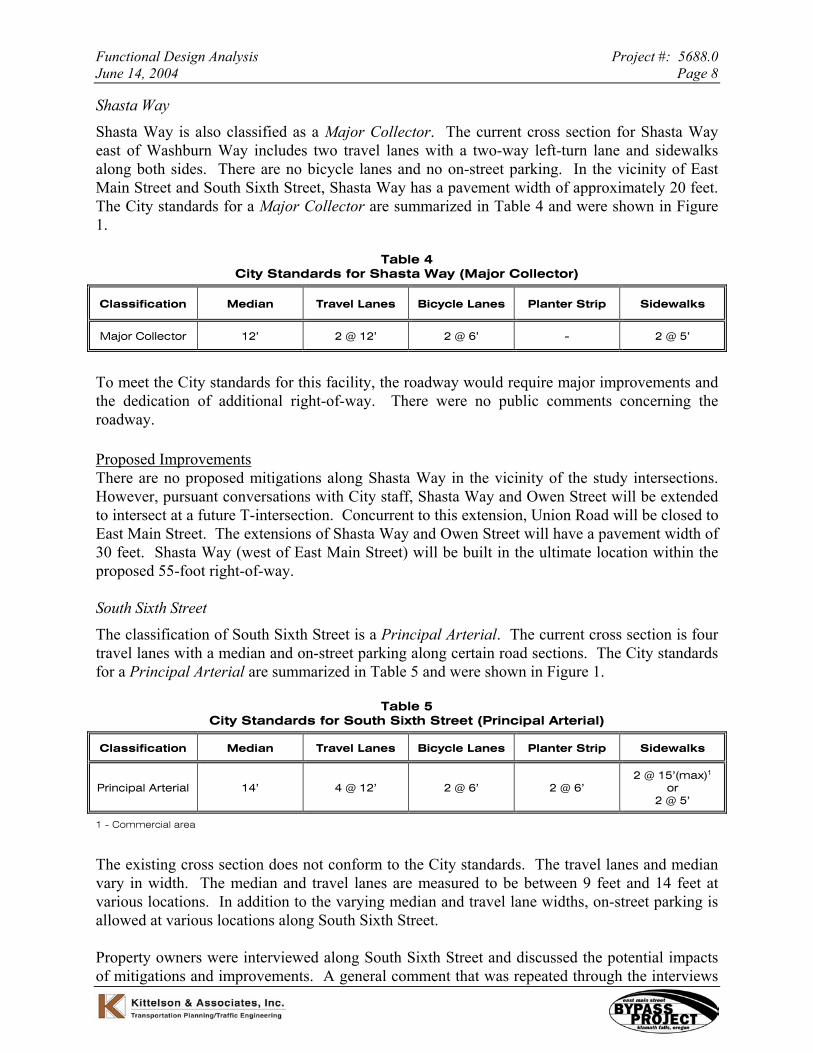
Shasta Way Shasta Way is also classified as a Major Collector. The current cross section for Shasta Way east of Washburn Way includes two travel lanes with a two-way left-turn lane and sidewalks along both sides. There are no bicycle lanes and no on-street parking. In the vicinity of East Main Street and South Sixth Street, Shasta Way has a pavement width of approximately 20 feet. The City standards for a Major Collector are summarized in Table 4 and were shown in Figure 1.
Table 4 City Standards for Shasta Way (Major Collector)
Classification Median Travel Lanes Bicycle Lanes Planter Strip Sidewalks
Major Collector 12’ 2 @ 12’ 2 @ 6’ - 2 @ 5’
To meet the City standards for this facility, the roadway would require major improvements and the dedication of additional right-of-way. There were no public comments concerning the roadway.
Proposed Improvements There are no proposed mitigations along Shasta Way in the vicinity of the study intersections. However, pursuant conversations with City staff, Shasta Way and Owen Street will be extended to intersect at a future T-intersection. Concurrent to this extension, Union Road will be closed to East Main Street. The extensions of Shasta Way and Owen Street will have a pavement width of 30 feet. Shasta Way (west of East Main Street) will be built in the ultimate location within the proposed 55-foot right-of-way.
South Sixth Street The classification of South Sixth Street is a Principal Arterial. The current cross section is four travel lanes with a median and on-street parking along certain road sections. The City standards for a Principal Arterial are summarized in Table 5 and were shown in Figure 1.
Table 5 City Standards for South Sixth Street (Principal Arterial)
Classification Median Travel Lanes Bicycle Lanes Planter Strip Sidewalks
Principal Arterial 14’ 4 @ 12’ 2 @ 6’ 2 @ 6’ 2 @ 15’(max)1
or 2 @ 5’
1 - Commercial area
The existing cross section does not conform to the City standards. The travel lanes and median vary in width. The median and travel lanes are measured to be between 9 feet and 14 feet at various locations. In addition to the varying median and travel lane widths, on-street parking is allowed at various locations along South Sixth Street.
Property owners were interviewed along South Sixth Street and discussed the potential impacts of mitigations and improvements. A general comment that was repeated through the interviews

Functional Design Analysis Project #: 5688.0 June 14, 2004 Page 9
was the difficulties of turning onto South Sixth Street from driveways during peak hour time periods. Some property owners also stated that they did not want to lose their existing on-street parking.
Proposed Improvements South Sixth Street will need to be widened substantially to meet the City’s standards. To minimize property impacts, the modifications to the City’s standards listed below were incorporated within the design.
• Reduce inside travel lanes to 11 feet.
• Eliminate on-street parking along South Sixth Street conforming to the City standards.
• Add and/or increase a center two-way left-turn lane to 14 feet.
• Increase the outside travel lane to 14 feet to accommodate for a shared bicycle travel lane. Eliminate exclusive bicycle lanes due to the proximity of the OC&E trail south of and parallel to South Sixth Street.
• Eliminate planter strips because no landscaping is provided along South Sixth Street in study area.
• Provide 5-foot sidewalks where necessary conforming to the City standard.
A consistent cross-section, as shown in Figure 4 is proposed for South Sixth Street within the study area. Beyond the study area, the proposed improvements will tie back into the existing cross-section.
Washburn Way Washburn Way is currently classified as a Major Collector. The cross section for Washburn Way consists of four travel lanes with a median and bicycle lanes. The City standards for a Major Collector are summarized in Table 6 and were shown in Figure 1.
Table 6 City Standards for Washburn Way (Major Collector)
Classification Median Travel Lanes Bicycle Lanes Planter Strip Sidewalks
Major Collector 12’ 2 @ 12’ 2 @ 6’ - 2 @ 5’
The current width of the bike lanes is 5 feet, and the width of the travel lanes is approximately 11 feet, which does not meet the City standard. Comments from property owners and the public indicate that there are also difficulties making left-turn movements to/from Washburn Way between the OC&E Trail and South Sixth Street during the peak hour time periods.

WESTBOUND EASTBOUND
PROPOSED ROAD PRISM = 74'
11'14'11'14' 14'5' 5'
SIDEWALK SIDEWALK
KITTELSON & ASSOCIATES, INC.
PROPOSED CROSS SECTION FOR SOUTH SIXTH STREETKLAMATH FALLS, OREGON 4
East Main Street Bypass Project June 2004
FIGURE
FIG
S03
-07.
dwg
Functional Design Analysis Project #: 5688.0 June 14, 2004 Page 11
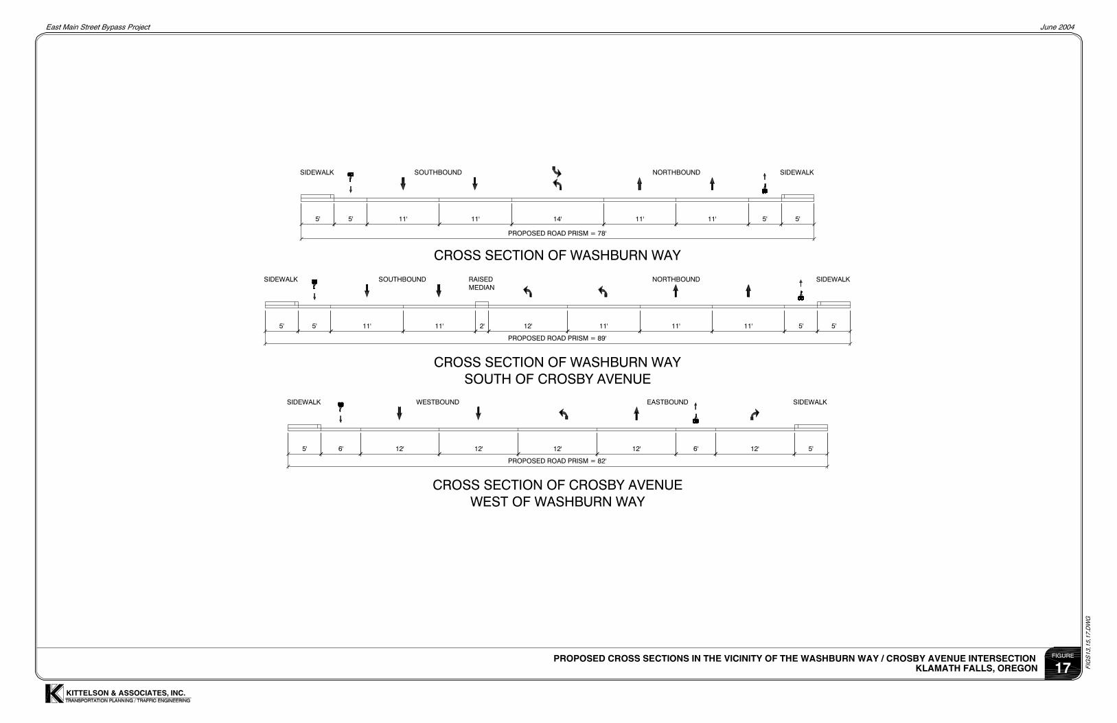
Proposed Improvements Due to the necessary mitigation measures at the South Sixth Street/Washburn Way intersection, there will be impacts to properties in the vicinity of this intersection. The northbound approach at the South Sixth Street/Washburn Way intersection will be widened to accommodate two northbound left-turn lanes. As a result, the southbound approach will require widening to align the through lanes with the necessary approach tapers.
There will be similar impacts at the Washburn Way/Crosby Avenue intersection. The northbound and southbound approaches at this intersection will be widened to accommodate the addition of the additional northbound left-turn lane. For the necessary widening and taper at the Washburn Way/Crosby Avenue intersection, Washburn Way will be widened to the west. This is within the existing right-of-way, but there will be impacts to an existing business parking area.
The typical cross-section, as shown in Figure 5, follows the existing cross sectional dimensions (i.e., the travel lanes of 11 feet, median of 14 feet, and bicycle lanes of five feet). The proposed roadway design will tie into the existing conditions beyond the proposed improvements.
Maywood Street The Klamath County classification for Maywood Street is Local Street. Currently, Maywood Street is a 2-lane roadway facility and does not meet County standards. The County standards for a Local Street are summarized in Table 7.
Table 7 County Standards for Maywood Street (Local Street)
Classification Median Share-The-Lane
On-Street Parking Planter Strip Sidewalks
Local Street No Parking - 2 @ 14’ - 2 @ 4’ 2 @ 5’
Local Street Parking on One
Side - 2 @ 14’ 1 @ 7’ 2 @ 4’ 2 @ 5’
Local Street Parking on Both
Sides - 2 @ 14’ 2 @ 7’ 2 @ 4’ 2 @ 5’
No public comments were made in regard to potential improvements along Maywood Street.
Proposed Improvements At this stage, no planter strips and/or sidewalks will be added to Maywood Street to meet the County standards because no mitigations are proposed along Maywood Street. At the Maywood Street/Crosby Avenue intersection, Maywood Street will be widened to have three 14-foot lanes to separate turning movements. The typical cross-section for this facility is shown in Figure 6.

NORTHBOUNDSOUTHBOUND
11'11'5' 5' 11' 14' 11' 5' 5'
PROPOSED ROAD PRISM = 78'
SIDEWALK SIDEWALK
KITTELSON & ASSOCIATES, INC.
PROPOSED CROSS SECTION FOR WASHBURN WAYKLAMATH FALLS, OREGON 5
East Main Street Bypass Project June 2004
FIGURE
FIG
S03
-07.
dwg

PROPOSED ROAD PRISM = 60'
14'14'
SOUTHBOUND NORTHBOUND
14'
PLANTER SIDEWALK
4' 5'4'5'
SIDEWALK PLANTER
KITTELSON & ASSOCIATES, INC.
PROPOSED CROSS SECTION FOR MAYWOOD STREETKLAMATH FALLS, OREGON 6
East Main Street Bypass Project June 2004
FIGURE
FIG
S03
-07.
dwg
Functional Design Analysis Project #: 5688.0 June 14, 2004 Page 14
Crosby Avenue Crosby Avenue is currently classified by Klamath County as a Minor Collector. The existing non-conforming cross section for Crosby Avenue is two travel lanes with no bike lanes. The County standards for a Minor Collector are summarized in Table 8.
Table 8 County Standards for Crosby Avenue (Minor Collector)
Classification Median Travel Lanes Bicycle Lanes Planter Strip Sidewalks
Minor Collector 12’ 2 @ 12’ 2 @ 5’ 2 @ 4’ 2 @ 5’
Comments from property owners and the public indicate that the proposed mitigations along Crosby Avenue will impact the businesses between Washburn Way and Maywood Street. Although there will be impacts to the businesses, property owners are open to the proposed improvements.
Proposed Improvements The Crosby Avenue cross section approximately 700 feet west of Maywood Street will match the cross section of the East Main Street Bypass cross section (as shown in Figure 3), which conforms to the Major Collector City standards. The section between Maywood Street and Washburn Way will transition from four to five lanes. Figure 7 shows the cross section of Crosby Avenue just east of Maywood Street. The two westbound lanes will receive the proposed traffic from the dual northbound left-turn lanes at the Washburn Way/Crosby Avenue intersection. (These two westbound lanes will merge to one lane west of the Maywood Street intersection.) The eastbound lanes in this section will accommodate left, through and right lanes. East of the Washburn Way/Crosby Avenue intersection, Klamath County is proposing to improve Crosby Avenue to a 40-foot roadway facility, which includes two 12-foot travel lanes and a 16-foot median (based on the Onyx Street design).

PROPOSED ROAD PRISM = 68'
5'12'12'12'5'5' 5'12'
WESTBOUNDEASTBOUNDSIDEWALK SIDEWALK
KITTELSON & ASSOCIATES, INC.
PROPOSED CROSS SECTION FOR CROSBY AVENUEKLAMATH FALLS, OREGON 7
East Main Street Bypass Project June 2004
FIGURE
FIG
S03
-07.
dwg

Functional Design Analysis Project #: 5688.0 June 14, 2004 Page 16
FINDINGS ACCORDING TO SEVEN IMPROVEMENT SUBPROJECTS
The following section evaluates the subprojects within the East Main Street Bypass project as shown in Figure 8. The functional design incorporated each of these subprojects as well as the previously described considerations. Truck turning templates were analyzed throughout each subproject to verify mobility and access of the design.
Subproject #1 - East Main Street Bypass
The East Main Street Bypass is designed as the continuation of East Main Street south of South Sixth Street and Crosby Avenue west of Washburn Way. The proposed alignment joins the two sections with a 750-foot radius curve as shown in Figure 9. The 750-foot radius curve (35 mph design speed) is the minimum radius for this roadway facility with no superelevation. As previously stated, the cross section of East Main Street Bypass will be designed according to City standards of a Major Collector as shown in Figure 3.
Appendix A (Figures R8 through R11) highlights the impacts to properties associated with Subproject #1.
Subprojects #2 and #6 - Access Management along Washburn Way, and Installation of Pedestrian/Bicycle Signal at OC&E Trail crossing on Washburn Way
In the future, several driveways are expected to experience relatively long delays, and there would be insufficient capacity along South Sixth Street and Washburn Way to accommodate minor street movements. Preliminary investigations indicate that some of the properties have two driveways and some of the properties are connected via cross over easements, which would provide alternative shared access. As noted earlier, property owners and the public have raised concerns with access and safety along Washburn Way and South Sixth Street.
In addition, pedestrian and bicycle movements were studied at the OC&E Trail crossing on Washburn Way. As concluded in Memorandum #9B, there are an insufficient number of adequate gaps to cross Washburn Way at the OC&E Trail crossing. A pedestrian/bicycle signal is not warranted due to low pedestrian volumes. However, a traffic signal would be warranted with the incorporation of a new signalized access on Washburn Way. The proposed OC&E Trail crossing in conjunction with a vehicular signalized access is shown in Figure 10.
Memorandum #9B determined the required storage at the Washburn Way/South Sixth Street intersection. The proposed access management along both Washburn Way and South Sixth Street still meet the recommended storages. The area along Washburn Way, south of South Sixth Street will have a raised median. This raised median will extend from the South Sixth Street/Washburn Way intersection to the new combined Burger King/Safeway Store driveway. At this driveway intersection, the driveways will be restricted to a left-in/right-in/right-out access only. Due to the limited access, vehicles will divert to the proposed signalized access at the OC&E trail crossing on Washburn Way to access local businesses. The proposed configuration of the area is shown in Figure 11. This new signal will be coordinated with the South Sixth Street/Washburn Way signal, therefore, minimizing delays along Washburn Way.

KITTELSON & ASSOCIATES, INC.
SUBPROJECT DIVISIONSKLAMATH FALLS, OREGON 8
East Main Street Bypass Project June 2004
FIGURE
H:\P
RO
JFIL
E\D
WG
S\F
DA
ME
MO
\FIG
S08
-12,
14,1
6,18
.dw
g
N(1" = 350')
EA
ST
MA
IN S
T
SOUTH 6TH STREET
WA
SH
BU
RN
WA
Y
MA
YW
OO
D S
TR
EE
T
CROSBY AVENUE
OC & E TRAIL
PR
OP
OS
ED
BY
PA
SS
OW
EN
S S
T
PROPOSED BYPASS (SUBPROJECT #1)
ACCESS MANAGEMENT & OC&E CROSSING (SUBPROJECTS #2 & #6)
LEGEND
IMPROVEMENTS AT EAST MAIN ST / SOUTH 6TH ST - NORTH PIECE (SUBPROJECT #3A)
IMPROVEMENTS AT WASHBURN WAY / SOUTH 6TH ST (SUBPROJECT #4)
IMPROVEMENTS AT CROSBY AVE / MAYWOOD ST / WASHBURN WAY (SUBPROJECT #5)
REHABILITATION ALONG SOUTH 6TH ST BETWEEN BROAD ST AND AUSTIN ST (SUBPROJECT #7)
IMPROVEMENTS AT EAST MAIN ST / SOUTH 6TH ST - SOUTH OF SOUTH 6TH ST (SUBPROJECT #3B)
SHASTA WAY

KITTELSON & ASSOCIATES, INC.
SUBPROJECT #1: PROPOSED EAST MAIN STREET BYPASS ALIGNMENTKLAMATH FALLS, OREGON 9
East Main Street Bypass Project June 2004
FIGURE
H:\P
RO
JFIL
E\D
WG
S\F
DA
ME
MO
\FIG
S08
-12,
14,1
6,18
.dw
g
N(1" = 300')
SHASTA WAY
EA
ST
MA
IN S
T
SOUTH 6TH STREET
WA
SH
BU
RN
WA
Y
MA
YW
OO
D S
TR
EE
T
CROSBY AVENUE
OC & E TRAIL
PR
OP
OS
ED
BY
PA
SS
EXISTING TRAFFIC SIGNAL TO BE MODIFIED
EXISTING TRAFFIC SIGNAL (UNCHANGED)
NEW TRAFFIC SIGNAL TO BE INSTALLED
EXISTING TRAFFIC SIGNAL TO BE MODIFIED
NEW TRAFFIC SIGNAL TO BE INSTALLED
EXISTING TRAFFIC SIGNAL TO BE MODIFIED

N(1" = 100')
KITTELSON & ASSOCIATES, INC.
SUBPROJECT #6: PROPOSED ROAD IMPROVEMENTS IN THE VICINITY OFWASHBURN WAY / OC&E TRAIL INTERSECTION
KLAMATH FALLS, OREGON 10
East Main Street Bypass Project June 2004
FIGURE
H:\P
RO
JFIL
E\D
WG
S\F
DA
ME
MO
\FIG
S08
-12,
14,1
6,18
.dw
g
OC & E TRAIL
WA
SH
BU
RN
WA
Y
NEW TRAFFIC SIGNAL TO BE INSTALLED

KITTELSON & ASSOCIATES, INC.
SUBPROJECT #2: PROPOSED ACCESS MANAGEMENT IN THE VICINITY OF THESOUTH SIXTH STREET/WASHBURN WAY INTERSECTION
KLAMATH FALLS, OREGON 11
East Main Street Bypass Project June 2004
FIGURE
H:\P
RO
JFIL
E\D
WG
S\F
DA
ME
MO
\FIG
S08
-12,
14,1
6,18
.dw
g
N
(1" = 100')
OC & E TRAIL
WASH
BUR
N W
AY
SOUTH 6TH ST
LARK ST
NEW TRAFFIC SIGNAL TO BE INSTALLED
EXISTING TRAFFIC SIGNAL TO BE MODIFIED
EXISTING TRAFFIC SIGNAL TO BE MODIFIED
NEW TRAFFIC SIGNAL TO BE INSTALLED

Functional Design Analysis Project #: 5688.0 June 14, 2004 Page 21
In addition, the South Sixth Street/Avalon Street intersection will be improved by adding an eastbound right-turn lane. The signal will be modified to accommodate the relocation of the signal pole due to the addition of the right-turn lane, as well as changing the existing permissive north-south phasing to protected left-turn phasing.
Several access alternatives were discussed with the property owners located in the southwest quadrant of the South Sixth Street/Washburn Way intersection. There was agreement that improvements are necessary to improve safety in the vicinity of this intersection. An internal access road system was developed to serve all the property owners in the southwest quadrant of this intersection. Traffic flow between and through these parking areas would be rerouted to the internal access road system and allow for vehicles to enter and exit the businesses via the two new signalized intersections on Washburn Way and South Sixth Street, respectively.
As discussed, the traffic signal on Washburn Way will be located at the OC&E Trail crossing. This signal would serve two purposes: the first would be to allow for easier access to the businesses in the southwest and southeast quadrants of the South Sixth Street/Washburn Way intersection; and the second would be to allow for patrons on the OC&E Trail to cross Washburn Way safely and easily. The second proposed traffic signal will be located at the South Sixth Street/Lark Street intersection. This traffic signal would also be utilized as another controlled access for the businesses in the southwest quadrant of the South Sixth Street/Washburn Way intersection. This new signal on South Sixth Street also fits well with the existing spacing of signalized intersections along South Sixth Street.
The reconfiguration of the internal road system in the southwest quadrant of the South Sixth Street/Washburn Way intersection requires the modification of several parking areas. There is a net gain of parking spaces within most of the parking areas with the exception of the Bi Mart, Diamond Improvement Warehouse, and the Turn Thom Tire Center properties. There is approximately a net loss of 15 parking spaces at Bi Mart’s property and approximately 25 parking spaces at Diamond Improvement property. The Turn Thom Tire Center property does not have a loss of parking spaces, but the impact is to the available area for displaying vehicles for sale. Although there are some impacts to property, there is potential accessibility and timesaving gains due to signalized access and optimized internal flow of traffic.
Subproject #3 - Modification of East Main Street/South Sixth Street intersection
As indicated in previous sections, implementing the bypass requires adding turn lanes at the East Main Street/South Sixth Street intersection. Three of the four corners of this intersection are developed and limit the options to improve this intersection. Intersection improvements are shown in Figure 12. Due to the need of additional turn lanes and the apparent impacts to existing conditions, lane widths were adjusted to limit the overall impacts. Figure 13 illustrates the proposed cross sections for the intersection approaches. In addition to reducing the lane widths, the widening of South Sixth Street will be focused to the north, avoiding impacts to an existing building in the southwest corner of the intersection.

N(1" = 100')
KITTELSON & ASSOCIATES, INC.
SUBPROJECT #3: PROPOSED ROAD IMPROVEMENTS IN THE VICINITY OFSOUTH 6TH STREET / SHASTA WAY / EAST MAIN STREET INTERSECTIONS
KLAMATH FALLS, OREGON 12
East Main Street Bypass Project June 2004
FIGURE
H:\P
RO
JFIL
E\D
WG
S\F
DA
ME
MO
\FIG
S08
-12,
14,1
6,18
.dw
g
UNION AVE
OW
EN
S S
T
EA
ST
MA
IN S
T
SOUTH 6TH STREET
SHASTA WAY
RADCLIFFE AVE
EXISTING TRAFFIC SIGNAL TO BE MODIFIED

WESTBOUND EASTBOUND
EASTBOUNDWESTBOUND
CROSS SECTION OF SOUTH SIXTH STREETWEST OF EAST MAIN STREET
12'14'5' 11' 12' 11' 5'
PROPOSED ROAD PRISM = 86'
2' 14'
PROPOSED ROAD PRISM = 74'
11'12'11'14' 14'
CROSS SECTION OF SOUTH SIXTH STREET EAST OF EAST MAIN STREET
NORTHBOUNDSOUTHBOUND
2'
PROPOSED ROAD PRISM = 70'
5'6'12'10'12'6'5' 12'
CROSS SECTION OF EAST MAIN STREET SOUTH OF SOUTH SIXTH STREET
SIDEWALK SIDEWALK
SIDEWALK SIDEWALK
SIDEWALKSIDEWALK RAISEDMEDIAN
PAINTEDMEDIAN
2'5' 5'
KITTELSON & ASSOCIATES, INC.
PROPOSED CROSS SECTIONS IN THE VICINITY OF THE EAST MAIN STREET / SOUTH SIXTH STREET INTERSECTIONKLAMATH FALLS, OREGON 13
East Main Street Bypass Project June 2004
FIGURE
FIG
S13
,15,
17.D
WG

Functional Design Analysis Project #: 5688.0 June 14, 2004 Page 24
To minimize further property impacts, curb radii were adjusted and do not meet the City standard of 40-foot curb radius in commercial and industrial areas. The northwest curb is designed with a 25-foot radius; the northeast and southwest curb are designed with a 40-foot radius; and the southeast corner is designed with a 30-foot radius. The roadway approaches are designed with 35:1 tapers to accommodate the required lanes at this intersection.
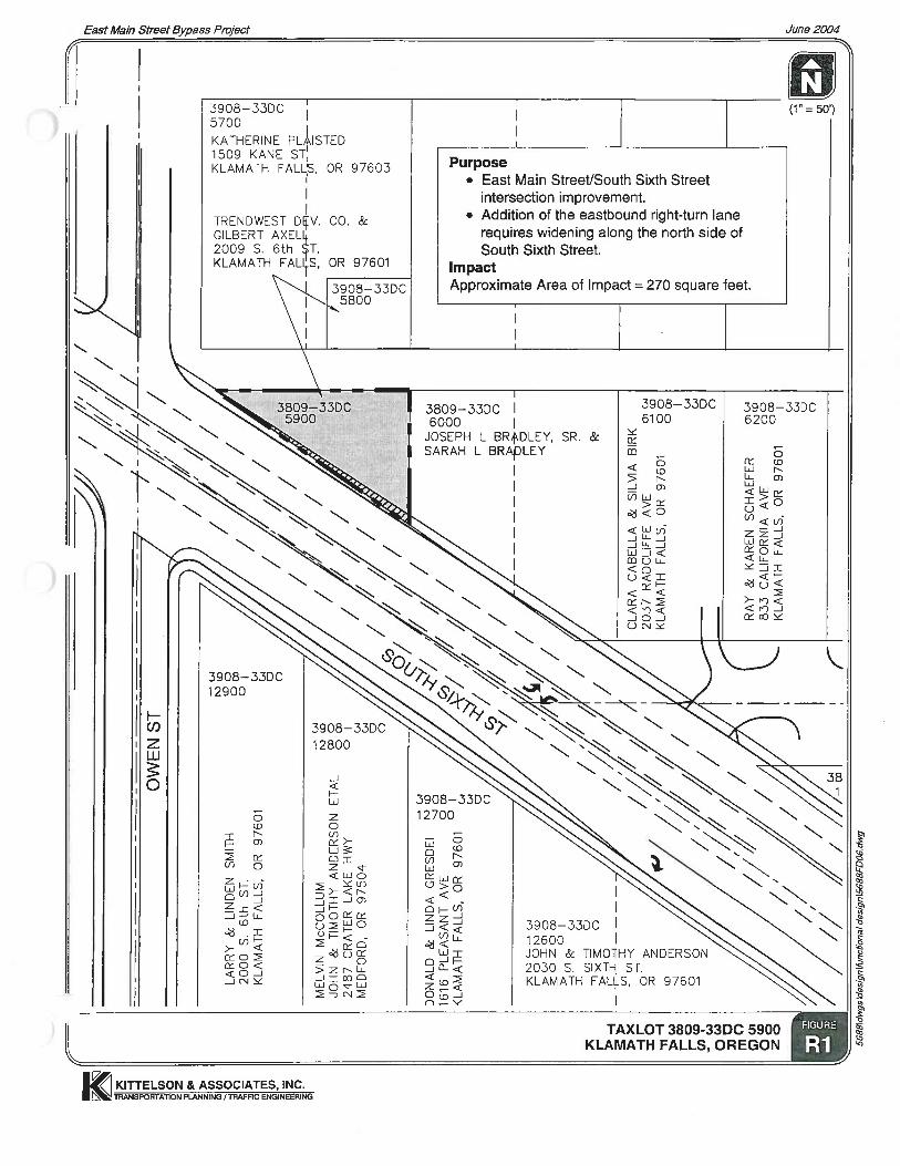
Appendix A (Figures R1 through R7) highlights the impacts to properties associated with Subproject #3.
Subproject #4 - Lengthening of Eastbound Right-Turn at South Sixth Street/Washburn Way intersection
The South Sixth Street/Washburn Way intersection requires near-term mitigation. Mitigation measures at this intersection include: lengthening (standardizing) the eastbound right-turn lane, changing the north-south phasing (split phase to protected left-turn) and modifying the lane configuration, including widening Washburn Way. Figure 14 shows the proposed intersection geometry. As part of this subproject, a 12-foot wide and 200-foot long eastbound right-turn lane was included in the design. To accommodate this turn lane and to minimize impacts to the existing gas station tanks, the inside through travel lane was decreased to 11 feet. The adjacent (outside) eastbound through lane was decreased from 14 feet wide to 11 feet wide. No bicycle lanes are provided along South Sixth Street. However, five-foot bike lanes are provided along Washburn Way through the intersection, which terminates at Pershing Way. Figure 15 illustrates the proposed cross sections for the intersection approaches.
It is proposed to re-stripe the westbound lanes along the east leg of the intersection to accommodate two 14-foot left-turn lanes, a 12-foot inside through lane and a 14-foot shared outside through/right-turn lane. In addition, the crosswalk at the south leg of the intersection is moved further south. Together, these re-striping mitigations would improve the operation of the westbound left-turn lanes. To accommodate the two northbound left-turn lanes, 35:1 tapers are provided along Washburn Way. The existing westbound taper along South Sixth Street at the Washburn Way intersection is approximately 15:1, which should be 35:1. With the re-striping of the lanes along the east leg of the intersection (the through lanes moved to the north by approximately five feet) and widening along the north side of South Sixth Street, west of Washburn Way, a 20:1 taper is accomplished.
The southwest and southeast curb radii are designed with 50-foot radii, while the northeast existing curb radius remains unchanged. The curb return radius in the northwest corner is designed with a 30-foot radius.
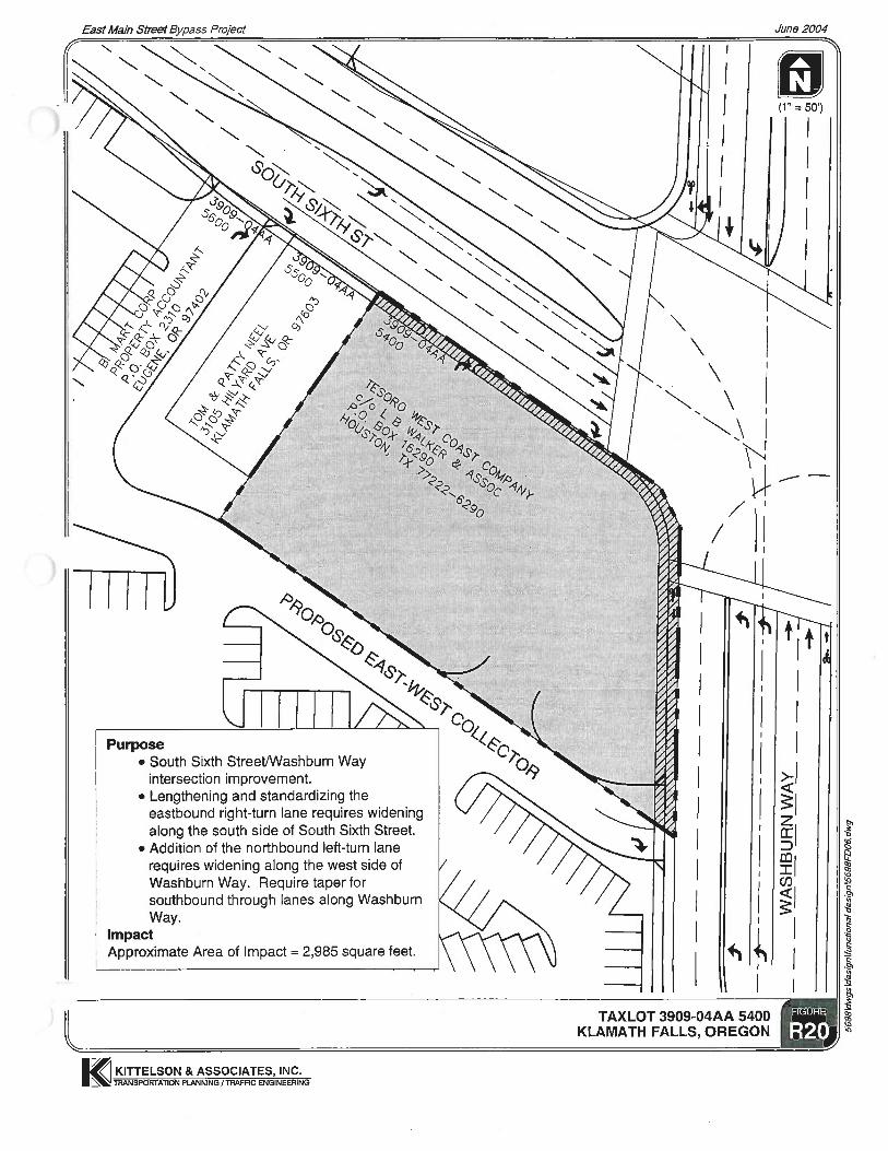
Appendix A (Figures R16 through R22) highlights the impacts to properties associated with Subproject # 4.

KITTELSON & ASSOCIATES, INC.
SUBPROJECT #4: PROPOSED ROAD IMPROVEMENTS IN THE VICINITY OFWASHBURN WAY / SOUTH 6TH STREET INTERSECTION
KLAMATH FALLS, OREGON 14
East Main Street Bypass Project June 2004
FIGURE
H:\P
RO
JFIL
E\D
WG
S\F
DA
ME
MO
\FIG
S08
-12,
14,1
6,18
.dw
g
N(1" = 100')
WA
SH
BU
RN
WA
Y
PERSHING WAY
SOUTH 6TH ST
EXISTING TRAFFIC SIGNAL TO BE MODIFIED
EXISTING TRAFFIC SIGNAL TO BE MODIFIED

EASTBOUNDWESTBOUND
EASTBOUNDWESTBOUND
5'5' 14' 12'
CROSS SECTION OF SOUTH SIXTH STREET EAST OF WASHBURN WAY
14' 14' 12' 14'
EXISTING ROAD PRISM= 94'
4'
CROSS SECTION OF SOUTH SIXTH STREET WEST OF WASHBURN WAY
11'14'5' 11' 12' 11' 5'
PROPOSED ROAD PRISM = 92'
VARIES 12'
NORTHBOUNDSOUTHBOUND
12'11'2'
PROPOSED ROAD PRISM = 101'
5'5'11'12'11'5'5' 11' 11'
CROSS SECTION OF WASHBURN WAY SOUTH OF SOUTH SIXTH STREET
SIDEWALK RAISED MEDIAN SIDEWALK
SIDEWALKSIDEWALK
SIDEWALK SIDEWALK
RAISEDMEDIAN
RAISEDMEDIAN
KITTELSON & ASSOCIATES, INC.
PROPOSED CROSS SECTIONS IN THE VICINITY OF THE SOUTH SIXTH STREET / WASHBURN WAY INTERSECTIONKLAMATH FALLS, OREGON 15
East Main Street Bypass Project June 2004
FIGURE
FIG
S13
,15,
17.D
WG

Functional Design Analysis Project #: 5688.0 June 14, 2004 Page 27
Subproject #5 - Aligning Crosby Avenue/Maywood Street intersection with Bypass
This intersection is located approximately 600 feet west of Washburn Way on the future bypass and is shown in Figure 16. This intersection would be potentially signalized in the future when the traffic demand requires mitigation. The side street approaches require an exclusive left-turn lane to minimize right-turn movement delays. The westbound approach will have a left-turn, through, and a shared through right-turn lanes. Figure 17 illustrates the proposed cross sections for the intersection approaches. The two through lanes will merge into one lane approximately 350 feet west of the intersection and match the typical cross-section for the East Main Street Bypass. The horizontal alignment of the bypass and Crosby Avenue was shifted to the south to avoid impacts to the Nature Conversancy property.
Due to the closely spaced intersections along Crosby Avenue, it is proposed that all the existing driveways along both sides between Washburn Way and Maywood Street be combined into one single unsignalized intersection. All property owners were acceptable with such an arrangement.
To accommodate the dual northbound left-turn, Washburn Way will be widened to the west. It appears the parking lot of the U-Haul property (located on the west side of Washburn Way) encroaches into the existing Washburn Way right-of-way. There is no impact to this property, but modifications to their parking lot will be necessary.
The curb radii are designed with 30-foot radii; which match the existing curb radii on the east side of the intersection.
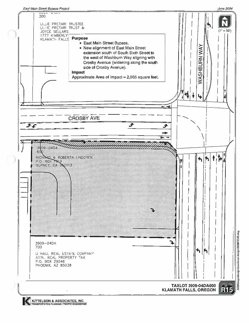
Appendix A (Figures R12 through R15) highlights the impacts to properties associated with Subproject #5.
Subproject #7 - Rehabilitation of South Sixth Street
This subproject involves the rehabilitation of South Sixth Street between Broad Street and Austin Street. This section is divided into subsections:
• From Broad Street over the existing South Sixth Street bridge (crossing the railroad) to about Owen Street will include rehabilitation of the pavement with the new striping matching the existing striping layout.
• Subproject #3 (Owen Street to Martin Street) includes the road improvements in the vicinity of the East Main Street/South Sixth Street intersection. This includes the rehabilitation of the existing pavement, the widening of South Sixth Street to the north and the striping to match the proposed intersection geometry.
• The section between Martin Street and the western driveway of Rite-Aid will rehabilitated and re-striped to accommodate a five-lane cross sections, as discussed previously and shown in Figure 4. No bicycle lanes and on-street parking are included in this cross-section. Left-turn lanes (two-way center-turn lane) are accommodated along South Sixth Street by retaining the existing curb-lines and only re-striping the pavement markings.

KITTELSON & ASSOCIATES, INC.
SUBPROJECT #5: PROPOSED ROAD IMPROVEMENTS IN THE VICINITY OFWASHBURN WAY / CROSBY AVENUE INTERSECTION
KLAMATH FALLS, OREGON 16
East Main Street Bypass Project June 2004
FIGURE
H:\P
RO
JFIL
E\D
WG
S\F
DA
ME
MO
\FIG
S08
-12,
14,1
6,18
.dw
g
N(1" = 100')
WA
SH
BU
RN
WA
Y
CROSBY AVENUE
MA
YW
OO
D S
TR
EE
T
PROPOSED BYPASS
EXISTING TRAFFIC SIGNAL TO BE MODIFIED
SOUTHBOUND NORTHBOUND
CROSS SECTION OF WASHBURN WAY
11'11'5' 11' 14' 11' 5'
PROPOSED ROAD PRISM = 78'
NORTHBOUNDSOUTHBOUND
11'2'
PROPOSED ROAD PRISM = 89'
5'5'11'12'11'5'5' 11' 11'
CROSS SECTION OF WASHBURN WAY SOUTH OF CROSBY AVENUE
EASTBOUNDWESTBOUND
12'
CROSS SECTION OF CROSBY AVENUE WEST OF WASHBURN WAY
6'5' 6' 12' 12' 12' 12' 5'
PROPOSED ROAD PRISM = 82'
SIDEWALK SIDEWALK
SIDEWALKSIDEWALK
SIDEWALK SIDEWALK
RAISEDMEDIAN
5' 5'
KITTELSON & ASSOCIATES, INC.
PROPOSED CROSS SECTIONS IN THE VICINITY OF THE WASHBURN WAY / CROSBY AVENUE INTERSECTIONKLAMATH FALLS, OREGON 17
East Main Street Bypass Project June 2004
FIGURE
FIG
S13
,15,
17.D
WG

Functional Design Analysis Project #: 5688.0 June 14, 2004 Page 30
• Subproject #4 (Western Rite-Aid Driveway to Avalon Street) includes the road improvements in the vicinity of the South Sixth Street/Washburn Way intersection. This includes the rehabilitation of the existing pavement, the widening of South Sixth Street and the striping to match the proposed intersection geometry.
• From Avalon Street to Austin Street will include rehabilitation of the pavement with the new striping matching the existing striping layout.
Figure 18 illustrated the geometry of the South Sixth Street corridor between Owen Street and Avalon Street.
General Comments Regarding Taper for Turn Lanes
The development of turn lanes for this project is not consistent due to intersection/driveway spacing within the study area. The proposed functional layouts reflects the following scenarios:
• No reverse curves are provided where a two-way center lane leads into a left-turn lane. A 75-foot gap is provided in advance of the left-turn striping.
• The majority of the tapers for turn pockets have a taper of 10:1. This results in reverse curves over a length of 120 feet for 12-foot turn lanes, or 240 feet for two 12-foot turn lanes.
• The spacing of the signalized intersections and the driveways along Washburn Way does not provide the latitude to provide sufficient taper lengths. A minimum taper of 5:1 is provided, which results in reverse curves over a length of 60 feet for 12-foot turn lanes.
SUMMARY AND NEXT STEPS
The preliminary functional layouts presented in this memorandum will form the basis and starting point for the next phase (detail design) of this project. Technical Memorandum #11 provides the cost estimate for proposed road improvements of the overall project, as well as the costs associated with each of the subprojects.

KITTELSON & ASSOCIATES, INC.
SUBPROJECT #7: REHABILITATION ALONG SOUTH SIXTH STREETKLAMATH FALLS, OREGON 18
East Main Street Bypass Project June 2004
FIGURE
H:\P
RO
JFIL
E\D
WG
S\F
DA
ME
MO
\FIG
S08
-12,
14,1
6,18
.dw
g
N(1" = 250')
SOUTH 6TH ST
WA
SH
BU
RN
WA
Y
PERSHING WAY
OW
EN
S S
T
EA
ST
MA
IN S
T
SHASTA WAY
OC & E TRAIL
AVAL
ON
ST
LAR
K S
T
PR
OP
OS
ED
BY
PA
SS
EXISTING TRAFFIC SIGNAL TO BE MODIFIED
EXISTING TRAFFIC SIGNAL (UNCHANGED)
NEW TRAFFIC SIGNAL TO BE INSTALLED
EXISTING TRAFFIC SIGNAL TO BE MODIFIED
EXISTING TRAFFIC SIGNAL TO BE MODIFIED