Embed Size (px)
Citation preview

515 E. Ocean Ave., Suite G Lompoc, CA 93401-1920 O: (805) 737-4119 | F: (805) 737-4121
ARCHAEOLOGY | PALEONTOLOGY CULTURAL RESOURCE MANAGEMENT www.appliedearthworks.com
MEMORANDUM
To: Kathleen Kennedy, City of Santa Barbara Community Development, Planning Division
From: Annie McCausland, M.A., Architectural Historian, Applied EarthWorks, Inc.
Date: January 31, 2019
Subject: De la Vina Street Bridge Replacement: Consistency of Historical Resources Evaluation Report (HRER) with the City of Santa Barbara Master Environmental Assessment (MEA) Guidelines for Archaeological Resources and Historic Structures and Sites (January 2002), Historic Structures/Sites Report Requirements
1.0 Introduction
Per the attached Historical Resources Evaluation Report (HRER), the City of Santa Barbara (City), with funding from the Federal Highway Administration (FHWA) administered by the California Department of Transportation (Caltrans), proposes to replace the De la Vina Street Bridge (51C0244) over Mission Creek in the city of Santa Barbara, Santa Barbara County, California. The project will replace the existing structurally deficient bridge with a new bridge at the same location. The proposed De la Vina Street Bridge Replacement Project involves removing the existing abutments and replacing the bridge deck with a longer and wider structure that will span Mission Creek. The project also requires the demolition of the commercial building at 2735 De la Vina Street and altering the front of the building at 2726 De la Vina to selectively remove the roof overhanging the roadway/sidewalk.
A total of nine commercial/residential properties are within the project architectural study area. All nine properties were formally evaluated for their potential eligibility for inclusion in the National Register of Historic Places (NRHP). One structure, Bridge 51C0244, is listed in the California Historic Bridge Inventory as Category 5, not eligible for the NRHP. None of the buildings and structures appears to meet the criteria for listing in the NRHP, either individually or as a component of a district. One building appears to qualify as a City Structure of Merit and is therefore considered a historical resource for the purposes of the California Environmental Quality Act (CEQA). The project will have a Less Than Significant (Class III) impact on the Structure of Merit.
Caltrans is the agency responsible for ensuring compliance with federal regulations applicable to the De la Vina Street Bridge Replacement Project. Applied EarthWorks, Inc. prepared an HRER following the content and format guidelines specified in the Caltrans Standard Environmental Reference (SER) Handbook, Vol. 2, Cultural Resources (January 2015). As a result, the HRER does not specifically follow the City Master Environmental Assessment (MEA) guidelines for Historic Structures and Sites Reports. However, evaluation of buildings and structures for preparation of the HRER was conducted in a manner that adheres to the City’s requirements. Summaries from the HRER and information augmenting these discussions is provided below. A separate memorandum addresses the archaeological investigations for the project, which are presented in an Archaeological Survey Report (ASR) that describes the inventory of the archaeological resources within the Area of Direct Impact as required by the MEA.

2
2.0 Historic Structures and Sites Reports
Per the MEA: A Historic Structures and Sites Report is an investigation intended to accomplish the following:
• Identify historic structures/sites on a proposed project site.
• Assess the significance of identified historic structures and/or sites.
• If significant historic resources are identified, evaluate potential project impacts to the significant historic resources.
• If the proposed project may potentially result in adverse impacts to identified historic resources, propose measures to mitigate the potential adverse impacts.
Applied EarthWorks assessed potential project impacts to significant historic structures using criteria specified in the MEA, classifying them as significant unavoidable (Class I), potentially significant unless mitigated (Class II), or less than significant (Class III).
Historical Resources Evaluation Report, Replacement of the De la Vina Street Street Bridge over Mission Creek (51C0244), City of Santa Barbara, Santa Barbara County, California details the significance evaluation of the properties surrounding the De la Vina Street Bridge (McCausland 2018). A total of nine properties are located within the project architectural study area. All nine properties, representing a total of 14 buildings and structures, were formally evaluated for historical significance by applying the criteria of the NRHP. Each is itemized in the HRER and further described on the appropriate California Department of Parks and Recreation (DPR) inventory forms: Primary Records (DPR523A) and Building, Structure, and Object Records (DPR 523B). The table below summarizes the findings for each property and its relationship to the project Area of Direct Impact (ADI).
Property Identified Relationship to
ADI Level of
Significance Potential Impact
Mitigation Proposed
2849 De la Vina Street Adjacent Not significant None No
2830 De la Vina Street Adjacent Not significant None No
2825 De la Vina Street Adjacent Not significant None No
2829 Vernon Road Adjacent Not significant None No
De la Vina Street Bridge Within Not significant None No
2814 Serena Road Adjacent Not significant None No
2735 De la Vina Street Within Not significant None No
2717 De la Vina Street Adjacent Not significant None No
2726 De la Vina Street Within Not significant None No
2720 De la Vina Street Adjacent Structure of Merit None No
Below, each historic resource is identified, assessed for significance, and evaluated for impacts, where necessary.

3
2849 De la Vina Street (1966)
The Mid-Century Modern commercial building at 2849 De la Vina was (Figure 1) constructed on a portion of the former Mountain View Auto Park that operated from 1924 to 1965. Mountain View Auto Camp, which occupied the southeast corner of Dixie Thompson’s Ontare Ranch, offered sleeping cabins for a dollar a night or a campsite for 50 cents a night, including laundry and restroom facilities. Structures and infrastructure associated with the park were demolished in 1965 to make way for a neighborhood shopping center. The lot was subdivided into two parcels and rezoned from multiple-family/trailer to restricted commercial. No remnants of the auto park remain on the property.
Mission Creek Shopping Center, originally known as Alpha Beta Plaza, was completed in 1966 by Duckett-Wilson Development Company, which was founded in 1964 by Robert S. Wilson and A. C. Duckett Jr., specializes in neighborhood commercial development. The company is still in businesses and is actively developing neighborhood shopping centers in central and southern California. Alpha Beta (store 176) occupied this building for many years, followed by Ralphs grocery store, which was a tenant for more than 20 years. These grocery stores catered to the residents of Oak Park and San Roque neighborhoods in Santa Barbara.
Figure 1 East façade of commercial building at 2849 De la Vina Street.
This commercial building is a Mid-Century Modern style that is commonly found in Santa Barbara and throughout California. The building does not appear to be significant for association with individuals important in the culture and development of Santa Barbara. It does not appear to have been involved in any significant events or possess character, interest, or value as a significant part of the city’s heritage. The property is not adjacent to any listed City Landmark or Structure of Merit, nor does the building represent an established and familiar visual feature of a neighborhood. Therefore, the building at 2849 De la Vina Street does not appear to be eligible for listing as a City Landmark or Structure of Merit under the MEA criteria.

4
2830 De la Vina Street (1966)
This Mid-Century Modern commercial building at 2830 De la Vina Street (Figure 2) was constructed on a portion of the former Mountain View Auto Park that operated from from 1924 to 1965. Structures and infrastructure associated with the park were demolished in 1965 to make way for a shopping center. The lot was subdivided into two parcels and rezoned from multiple-family/trailer to restricted commercial. No remnants of the auto park remain on the property.
Figure 2. West façade of commercial building at 2830 De la Vina Street.
Mission Creek Shopping Center, originally known as Alpha Beta Plaza, was completed in 1966 by Duckett-Wilson Development Company. The company, founded in 1964 by Robert S. Wilson and A. C. Duckett Jr., is still in businesses and is actively developing neighborhood shopping centers in central and southern California. The first tenants included Mission Pharmacy, Regal Laundromat, Grocery Unlimited Liquor, and W. W. Violet Jr. Chiropractor. The small businesses within this building have included beauty parlors, restaurants, dry cleaners, pet stores, liquor stores, and drug stores, all catering to Oak Park and San Roque residents.
This commercial building is a Mid-Century Modern in style that is commonly found in Santa Barbara and throughout California. The building does not appear to be significant for association with individuals important in the culture and development of Santa Barbara. The property does not appear to have been involved in any significant events or possess character, interest, or value as a significant part of the city’s heritage. The property is not adjacent to any listed City Landmark or Structure of Merit, nor does the building represent an established and familiar visual feature of a neighborhood. Therefore, the building at 2830 De la Vina Street does not appear to be eligible for listing as a City Landmark or Structure of Merit under the MEA criteria.

5
2825 De la Vina Street (1945)
This vernacular commercial building at 2825 De la Vina Street also includes a workshop in the rear (Figures 3 and 4). Hollister Heights Block B Lots 22 and 23 were vacant until 1945 when property owner W. T. Andrews had a 360 square foot commercial building constructed. Long C. A. Liquors occupied the building from 1948 until 1952. Samarkand Liquors and Passi’s Barber Shop occupied the building from 1953 to 1959. From 1960 to 1963 Spears Hunting Enterprises and Dick’s Barber Shop occupied the building, followed by Decorative Arts in 1964. In 1965 the building was remodeled for the Hut Tavern. Nancy and Richard Carroll purchased the property in 1975 and still own and operate Carroll Plumbing and Maintenance Inc. in the building.
Figure 3 East and north façades of commercial building at 2825 De la Vina Street.
Figure 4 Rear workshop at 2825 De la Vina Street, looking west.

6
This vernacular commercial building and workshop are of a basic building style that is commonly found in Santa Barbara and California. The buildings do not appear to be significant for association with individuals important in the culture and development of Santa Barbara. The property does not appear to have been involved in any significant events or possess character, interest, or value as a significant part of the city’s heritage. The property is not adjacent to any listed City Landmark or Structure of Merit nor does the building represent an established and familiar visual feature of a neighborhood. Therefore, the building and workshop at 2825 De la Vina Street do not appear to be eligible for listing as a City Landmark or Structure of Merit under the MEA criteria.
2829 Vernon Road (1945)
The property at 2829 Vernon Road contains a vernacular commercial building with Spanish Colonial Revival influences (Figure 5). The building was constructed in the city of Santa Barbara Hollister Heights neighborhood on Block B, Lot 24. This property remained undeveloped until 1945 when property owner Fred W. Gordon constructed a commercial building with an attached garage. In 1947 Gordon added an attached dwelling. His family lived in the dwelling and managed a radio shop in the commercial portion of the building until 1949. A variety of businesses have occupied the building, including Professional Ambulance Service, Santa Barbara Church of God, Hatton Lettershop, May Fare Wines, Internal Revenue Service, Work Training Programs, and currently Nick Rail Music.
Figure 5 East façade of 2829 Vernon Road, looking west.
The commercial building’s vernacular style with Spanish Colonial Revival influences is commonly found in Santa Barbara and California. The building does not appear to be significant for association with individuals important in the culture and development of Santa Barbara. The property does not appear to have been involved in any significant events or possess character, interest, or value as a significant part of the city’s heritage. The property is not adjacent to any listed City Landmark or Structure of Merit nor does the building represent an established and familiar visual feature of a neighborhood. Therefore, the building at 2829 Vernon Road does not appear to be eligible for listing as a City Landmark or Structure of Merit under the MEA criteria.

7
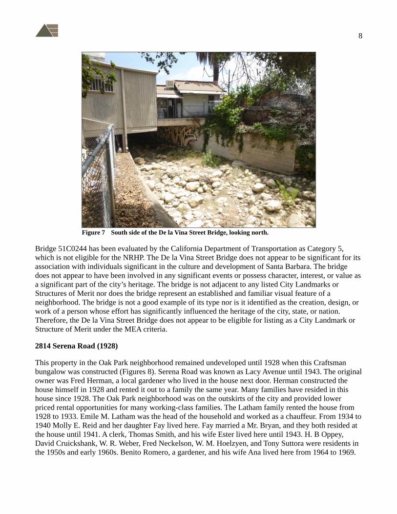
De la Vina Street Bridge (1916)
The De la Vina Street Bridge (51C0244) crosses Mission Creek at De la Vina Street, between Vernon Road and Alamar Avenue (Figures 6 and 7). Early maps of Santa Barbara depict Mission Creek, originally known as Arroyo del Pedregoso, as much broader than it is today. Fords were used to cross it until the late 1870s, when a series of wagon bridges were built spanning the creek along major streets. Many roads crossed Mission Creek in 1853, but the nature of the bridges or crossings are not specified. At Hollister Avenue (later De la Vina Street) much of the creek was channelized—stone retaining walls were constructed at each street intended to maintain the creek channel.
Figure 6 De la Vina streetscape, looking northeast from the bridge.
There was a large storm beginning on January 23 and culminating on Sunday, January 25, 1914, during which Mission Creek flooded. In the aftermath of the flood, several propositions for dealing with the “Mission Creek problem” were devised. One was to divert the creek waters to Arroyo Burro above Oak Park; the other was to divert the waters at Micheltorena, then construct a canal along the Santa Barbara Mesa. Whether or not to have a bridge over the creek on all the streets it crossed was another issue considered. In March 1914, the city approved a special tax levy to repair the storm damage, including reconstruction of the damaged bridges. As a result of the tax approval, new bridges were constructed at Carrillo, De la Guerra, Ortega, Bath, Haley, Hollister (De la Vina), and Mission streets in 1914–1916.
The De la Vina Street Bridge was designed after the De la Guerra Bridge with new concrete abutments. It was constructed between 1915 and 1916, replacing an earlier wood bridge. In 1926 the downstream side of the bridge was widened to accommodate a new private parcel. Two commercial buildings have been extant on the private parcel since this date.
8
Figure 7 South side of the De la Vina Street Bridge, looking north.
Bridge 51C0244 has been evaluated by the California Department of Transportation as Category 5, which is not eligible for the NRHP. The De la Vina Street Bridge does not appear to be significant for its association with individuals significant in the culture and development of Santa Barbara. The bridge does not appear to have been involved in any significant events or possess character, interest, or value as a significant part of the city’s heritage. The bridge is not adjacent to any listed City Landmarks or Structures of Merit nor does the bridge represent an established and familiar visual feature of a neighborhood. The bridge is not a good example of its type nor is it identified as the creation, design, or work of a person whose effort has significantly influenced the heritage of the city, state, or nation. Therefore, the De la Vina Street Bridge does not appear to be eligible for listing as a City Landmark or Structure of Merit under the MEA criteria.
2814 Serena Road (1928)
This property in the Oak Park neighborhood remained undeveloped until 1928 when this Craftsman bungalow was constructed (Figures 8). Serena Road was known as Lacy Avenue until 1943. The original owner was Fred Herman, a local gardener who lived in the house next door. Herman constructed the house himself in 1928 and rented it out to a family the same year. Many families have resided in this house since 1928. The Oak Park neighborhood was on the outskirts of the city and provided lower priced rental opportunities for many working-class families. The Latham family rented the house from 1928 to 1933. Emile M. Latham was the head of the household and worked as a chauffeur. From 1934 to 1940 Molly E. Reid and her daughter Fay lived here. Fay married a Mr. Bryan, and they both resided at the house until 1941. A clerk, Thomas Smith, and his wife Ester lived here until 1943. H. B Oppey, David Cruickshank, W. R. Weber, Fred Neckelson, W. M. Hoelzyen, and Tony Suttora were residents in the 1950s and early 1960s. Benito Romero, a gardener, and his wife Ana lived here from 1964 to 1969.

9
Figure 8 South façade at 2814 Serena Road.
The dwelling is a simple Craftsman bungalow style that is commonly found in Santa Barbara and throughout California. The building does not appear to be significant for association with individuals important in the culture and development of Santa Barbara. It does not appear to have been involved in any significant events or possess character, interest, or value as a significant part of the city’s heritage. The property is not adjacent to any listed City Landmark or Structure of Merit nor does the building represent an established and familiar visual feature of a neighborhood. Therefore, the residence at 2814 Serena Road does not appear to be eligible for listing as a City Landmark or Structure of Merit under the MEA criteria.
2735 De la Vina Street (1948)
This Spanish Colonial Revival style commercial building at 2735 De la Vina Street rests on the De la Vina Street Bridge over Mission Creek. The De la Vina Street Bridge was constructed in 1916. In 1927 Elmer H. Whittaker commissioned a new segment of the bridge at the south end to add to his property. The extant commercial building was constructed in 1948 as the Black V C restaurant and grocery that was in operation for 1 year. From 1951 to 1957, Frymire’s Fine Foods occupied the west portion of the building. Twin Burger Drive-In was in operation from 1955 to 1978 on the east side. Minute Market occupied the west portion from 1961 to 1976, and Marty’s Pizza has occupied the east side since 1985.
The commercial building is in the Spanish Colonial Revival, a style that is commonly found in Santa Barbara and California. The building does not appear to be significant for association with individuals important in the culture and development of Santa Barbara. The property does not appear to have been involved in any significant events or possess character, interest, or value as a significant part of the city’s heritage. The property is not adjacent to any listed City Landmark or Structure of Merit nor does the building represent an established and familiar visual feature of a neighborhood. Therefore, the building

10
at 2735 De la Vina Street does not appear to be eligible for listing as a City Landmark or Structure of Merit under the MEA criteria.
Figure 9 North and east façades of 2735 De la Vina Street.
2717 De la Vina Street (1919)
The subject property contains a trailer park and a laundry facility (Figures 10 and 11). The subject property is in the Oak Park Tract, Block A, Lots 6 and 7. The 1912 Barry map of the city shows that the property was owned by A. Goux, and it was undeveloped until 1919. With the advent of the automobile and the completion of Coast Highway 101, auto parks were established in coastal cities and counties to accommodate the growing number of travelers and tourists. The first auto camp in Santa Barbara, privately owned Hawkins Camp, was established in 1916 on the Coast Highway near Cacique and Salinas streets. Vacation travel decreased substantially during World War I, and Hawkins Camp was closed. As soon as the war was over, the Santa Barbara Chamber of Commerce was eager to open a new auto camp with sanitary improvements and other conveniences. In early 1919, after almost four months of negotiations, a committee selected the Goux property on De la Vina Street near Mission Creek. Day labor was used to construct the park facilitates, and the park was opened for Fourth of July weekend that year. The original camp included a community kitchen, six bungalows, and wooden decks for tents. This site was used as a tourist auto camp for about 25 years. In 1946, the camp was converted into a trailer park, and the extant laundry facility was constructed. The original camp infrastructure is no longer extant.
Due to the loss of all features representing the auto camp, the property no longer conveys its original use. Today it is a trailer park and does not appear to be significant for association with individuals important in the culture and development of Santa Barbara. The property does not now represent any significant events or possess character, interest, or value as a significant part of the city’s heritage. The property is not adjacent to any listed City Landmark or Structure of Merit, nor does the trailer park and

11
laundry facility represent an established and familiar visual feature of a neighborhood. Therefore, the trailer park and laundry facility at 2717 De la Vina Street does not appear to be eligible for listing as a City Landmark or Structure of Merit under the MEA criteria.
Figure 10 Trailer park at 2717 De la Vina Street.
Figure 11 East façade of laundry facility at 2717 De la Vina Street.

12
2726 De la Vina Street (1923-1925)
The subject property contains five buildings: a commercial building, a single-family dwelling, a storage structure, a shed, and a detached garage (Figures 12, 13, 14, 15). The dwelling was constructed on the property in 1923, and Etta T. Royce is listed as living at this address at that time. J. P. Starring lived at this address in 1924. In 1925, property owner W. J. Kehoe had a vulcanizing tire shop (commercial building) constructed on the property along Hollister Avenue (De la Vina Street) in front of the extant dwelling. R. S. Thomas is listed as living at this address in 1925. In 1927 the shop was owned and managed by the Davis Brothers. Otto L. Davis and Emmet Davis, originally from Missouri, ran the Davis Auto Repair Shop in the commercial building until the 1940s. Property owner, mechanic, and shop manager Emmet Davis lived in the subject dwelling with his wife and daughter from 1928 until early 1931. Otto, Ana, and Ethel Davis lived in the subject dwelling until 1939. A couple of additional dwellings constructed on the property behind the auto garage were rented to single occupants. These dwellings were demolished sometime in the 1950s–1960s, and the auto shop was remodeled into two business spaces. In 1961 a business called the House of Glass took residence in the building. Many businesses have occupied the building from 1961 to the present. The dwelling is currently used by one of the businesses as a day spa.
Figure 12 South façade of commercial building located at 2726 De la Vina Street.
The property does not appear to be significant for association with individuals important in the culture and development of Santa Barbara. The property does not appear to have been involved in any significant events or possess character, interest, or value as a significant part of the city’s heritage. The property is not adjacent to any listed City Landmark or Structure of Merit nor do the buildings represent an established and familiar visual feature of a neighborhood. Therefore, the property and buildings at 2726 De la Vina Street does not appear to be eligible for listing as a City Landmark or Structure of Merit under the MEA criteria.

13
Figure 13 East façade of dwelling at 2726 De la Vina Street.
Figure 14 South and west façades of storage structure at 2726 De la Vina Street.

14
Figure 15 Garage and shed at 2726 De la Vina Street, looking west.
2720 De la Vina Street (1937)
The property at 2720 De la Vina Street contains a storefront masonry building constructed in 1937 and designed by prominent local architect Keith E. Lockard. The property is in the city of Santa Barbara Thompson Lacy Subdivision, Lot 13–14. The parcel remained undeveloped until the construction of a Safeway grocery store in 1937. The Safeway catered to travelers on Hollister Avenue (De la Vina Street), campers staying at the auto camps that were once on the 2700 block of De la Vina Street, and the neighborhoods of Oak Park, Samarkand, and San Roque from 1937–1951. Since then Wood Furniture Co. (Figure 16), Lakes Furniture House, and Siesta Sleep Centre have occupied the building. The building was remodeled in 2016 and is currently occupied by Handlebar Coffee Roasters (Figure 17).
The masonry building was designed as a Safeway, one of the first grocery stores on the outskirts of the city. It was designed by Keith E. Lockard, who also designed Santa Barbara City Hall in the 1920s and the Unitarian Society of Santa Barbara in 1930. The building is associated with Lockard, a person who significantly contributed to architecture in the City of Santa Barbara, making the property eligible for listing as a Structure of Merit under MEA Criterion C. The building is also the best exemplification of a commercial storefront masonry building in the neighborhood, making the property eligible for listing as a City Structure of Merit under MEA Criterion E. The masonry building does retain the physical characteristics representing an established and familiar visual feature in the neighborhood. As such, the property appears to be eligible for listing as a City of Santa Barbara Structure of Merit under MEA Criterion I.

15
Figure 16 Wood Furniture Company at 2720 De la Vina Street, circa 1960s.
Figure 17 South and west façades of 2720 De la Vina Street.

16
To be eligible for listing, the storefront masonry building must retain sufficient integrity to convey its significance as a Structure of Merit. The seven aspects of integrity are discussed individually below.
• The building has not been moved and retains integrity of location.
• The surrounding buildings and infrastructure date to the early twentieth century, preserving the setting.
• The building continues to function as a commercial space and is recognizable as the original 1937 retail space, as such the building retains integrity of feeling and association.
• Although the primary façade was updated in 2016 with new wood framed windows and a new entryway on the east façade, the building retains the majority of its original materials. The building features its original concrete walls, divided light transom, brick pilasters and corners, parapet marquis with ogee curves and a zig-zag (see Figure 17), preserving integrity of materials and craftsmanship.
• The fenestration pattern on the primary façade is unaltered, preserving Lockard’s original storefront design.
As the building retains sufficient integrity to convey its significance, the property appears to be eligible for listing as a City of Santa Barbara Structure of Merit under MEA Criterion C, E, and I. As a locally eligible property, it is also considered to be a historical resource for the purpose of CEQA. The project will have a Less Than Significant (Class III) impact on the Structure of Merit because it is outside the Area of Direct Impact defined for the bridge replacement and there will there be no indirect impacts due to construction.
De la Vina Street 2700 Block
To ascertain the setting and types of built environment resources, this study included a windshield survey of the 2700 Block of De la Vina Street. As defined by the City of Santa Barbara Community Development Department, this block is a part of the Oak Park neighborhood. This block is a commercial corridor that appears to exhibit several periods of development spanning the 1920s to 1960s. Due to the lack of cohesive styles, the 2700 Block of De la Vina Street does not appear to possess the integrity required for consideration as a historic district.
3.0 Content and Format
Applied EarthWorks Architectural Historian Annie McCausland (M.A.) performed background archival research, conducted the architectural field survey, and prepared the HRER and this memorandum. Applied EarthWorks Senior Architectural Historian M. Colleen Hamilton (M.A., RPA) as Project Manager completed a technical review of the documents. Following review and approval by Caltrans, City regulatory personnel, and the Historic Landmarks Commission, the final documents will be filed at the City Community Development and Public Works departments, the Gledhill Library at the Santa Barbara Historical Museum, and the Central Coast Information Center of the California Historical Resources Information System at the University of California, Santa Barbara.
The HRER cover page lists the name and address of the applicant and the consultant preparing the report, along with the date the report was prepared. Kathleen Kennedy, Associate Planner, is the point of contact for City of Santa Barbara Community Development, Planning Division (805-564-5470, ext. 4560; [email protected]). Telephone and e-mail contact information for Annie

17
McCausland is 714-371-6277, [email protected]. M. Colleen Hamilton can be contacted at 951-766-2000 or [email protected].
The addresses for the properties within the project study area are listed in the table on page 2 and illustrated on Map 3 of the attached HRER.
In compliance with City Historic Structures and Site Report requirements, the Caltrans HRER contains the following.
• Table of contents, project description, documents review, and identification of previously recorded resources; identification and description of resources in the vicinity.
• A review of all the required information sources listed in MEA Section 2.4—within the MEA-designated sensitivity zones: Spanish Colonial and Mexican Period; Hispanic-American Transition Period; American Period; and Early Twentieth Century.
• A site history, including neighborhood context, lot, historic events, associated persons, etc., along with architectural and social history of each structure detailed on the respective DPR Record.
• A field inventory, identifying previously and newly recorded resources, including DPR record forms (as detailed above).
• Photographs of buildings, structures, and objects, including surrounding streetscapes.
• An assessment of historic structures/sites, based on results of documents review and field inventory. Additional assessments for local eligibility criteria are detailed within this memorandum.
• An evaluation of potential project impacts are detailed above.
• Recommended action/mitigation measures are not included in the HRER, as required by Caltrans, but have been provided in detail above.
• No residual impacts are expected.
• A list of research resources utilized in report preparation is provided in the HRER and includes all resources required in the MEA.
• Appendices: including maps, Caltrans Bridge Inventory Sheet, and DPR forms.
Please consider the above additional information and contact me if you have any questions or concerns.