Embed Size (px)
Citation preview
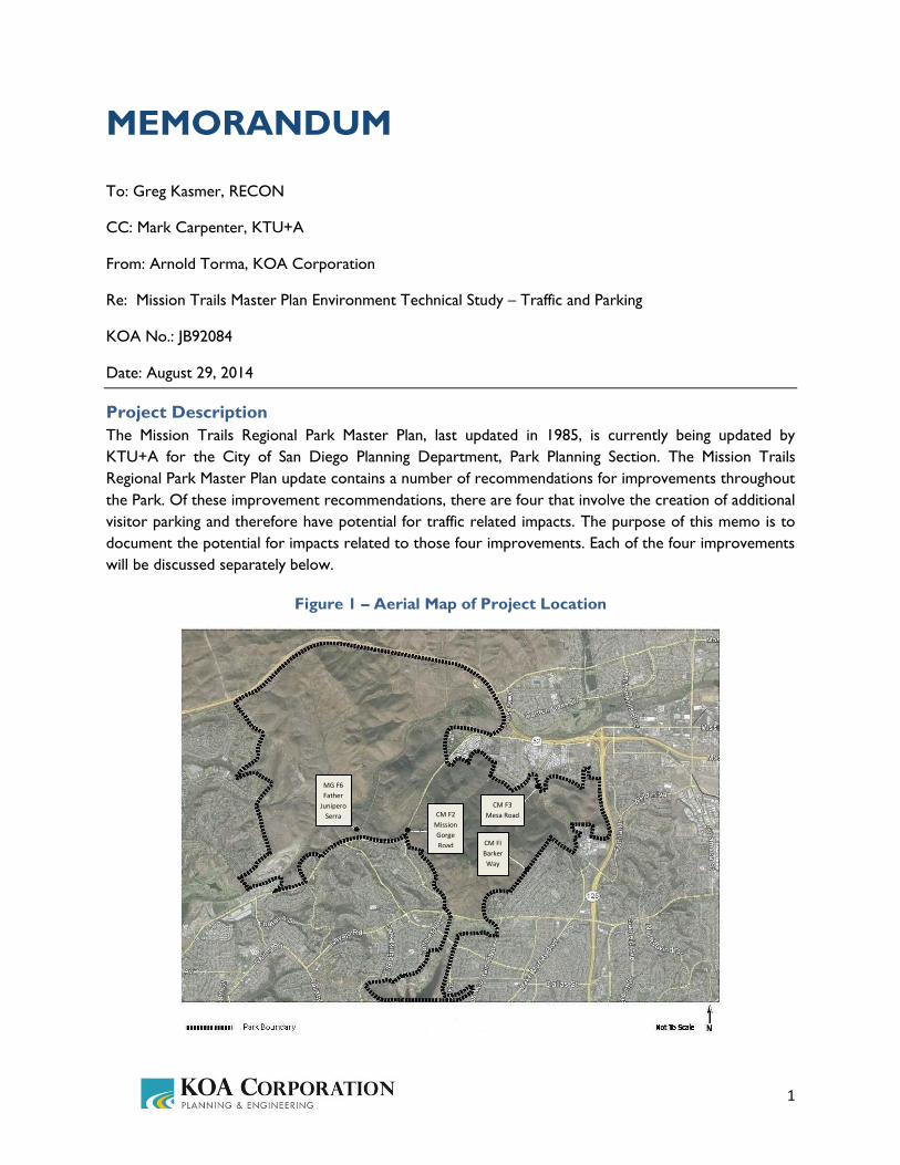
1
MEMORANDUM
To: Greg Kasmer, RECON
CC: Mark Carpenter, KTU+A
From: Arnold Torma, KOA Corporation
Re: Mission Trails Master Plan Environment Technical Study – Traffic and Parking
KOA No.: JB92084
Date: August 29, 2014
Project Description
The Mission Trails Regional Park Master Plan, last updated in 1985, is currently being updated by
KTU+A for the City of San Diego Planning Department, Park Planning Section. The Mission Trails
Regional Park Master Plan update contains a number of recommendations for improvements throughout
the Park. Of these improvement recommendations, there are four that involve the creation of additional
visitor parking and therefore have potential for traffic related impacts. The purpose of this memo is to
document the potential for impacts related to those four improvements. Each of the four improvements
will be discussed separately below.
Figure 1 – Aerial Map of Project Location
CM FI
Barker
Way
CM F2
Mission
Gorge
Road
MG F6
Father
Junipero
Serra
CM F3
Mesa Road
2
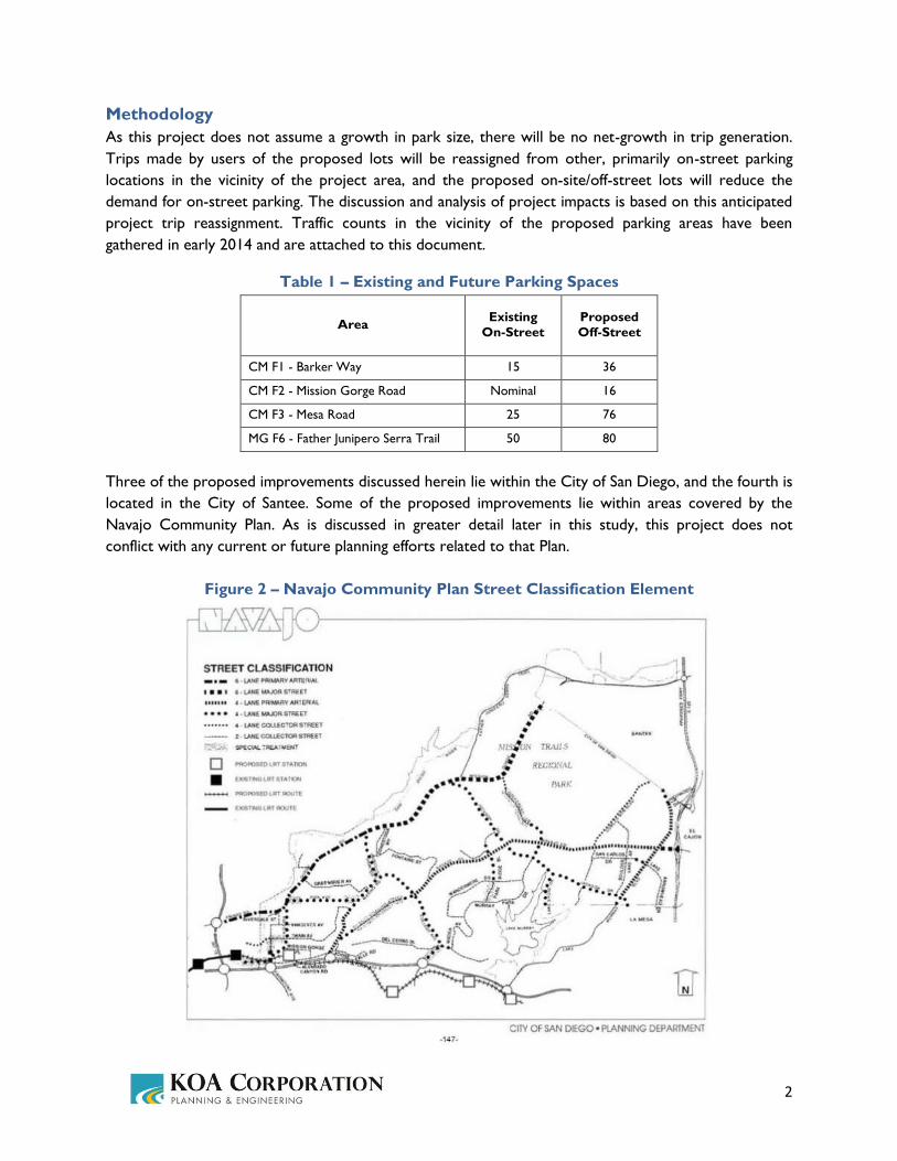
Methodology
As this project does not assume a growth in park size, there will be no net-growth in trip generation.
Trips made by users of the proposed lots will be reassigned from other, primarily on-street parking
locations in the vicinity of the project area, and the proposed on-site/off-street lots will reduce the
demand for on-street parking. The discussion and analysis of project impacts is based on this anticipated
project trip reassignment. Traffic counts in the vicinity of the proposed parking areas have been
gathered in early 2014 and are attached to this document.
Table 1 – Existing and Future Parking Spaces
Area Existing
On-Street
Proposed
Off-Street
CM F1 - Barker Way 15 36
CM F2 - Mission Gorge Road Nominal 16
CM F3 - Mesa Road 25 76
MG F6 - Father Junipero Serra Trail 50 80
Three of the proposed improvements discussed herein lie within the City of San Diego, and the fourth is
located in the City of Santee. Some of the proposed improvements lie within areas covered by the
Navajo Community Plan. As is discussed in greater detail later in this study, this project does not
conflict with any current or future planning efforts related to that Plan.
Figure 2 – Navajo Community Plan Street Classification Element

3
Proposed Improvements and Impacts
CM F1 – Barker Way, Parking
Proposal
Plan, design and implement off-street gravel or decomposed granite surfaced parking area for 36 cars at
the Barker Way entrance to reduce some of the parking demand on the local residential streets and
provide a more formal trailhead and potential for a maintainable comfort station.
Figure 3 – CM F1 - Barker Way Parking
Discussion
Barker Way in this area is a City of San Diego street that is paved, has two lanes, and is a single-loaded
residential street with full improvements on the eastern side along the adjacent homes. On the western
side abutting Mission Trails Park there is no sidewalk improvement in the block between Boulder Lake
Avenue and Coleshill Drive where access is taken to the park and where the parking lot is proposed.
The curb on the western side is formed in asphalt rather than in concrete. In this block the street varies
in width from approximately 30 feet to approximately 24 feet. In the blocks to the north and south of
this section there are full improvements on both sides of Barker Way consistent with the presence of
homes on both side of the street.
Visitors parking to hike in the Park will typically park on the west side adjacent to the park, but some
drivers park adjacent to the homes on the eastern side. The number of existing users varies between
approximately seven and fifteen parked vehicles on the street using the park at different times of the
day. This project will reduce the demand for on-street parking with the addition of the off-street lot.
Traffic volumes on Barker Way in early 2014 have been measured as 310 ADT (average daily traffic) or
vehicles per day on a weekday, and 730 per day on a weekend. These volumes are consistent with the
36 Spaces

4
classification the City calls “single loaded residential street” which is meant to carry no more than 1,500
vehicles per day. As this project does not include a growth in park size, there is no anticipated net-
growth in trip generation, and as project trip reassignment will be minimal, it can be determined that the
project will have no traffic related impacts.
CM F2 – Mission Gorge Rd, Parking
Proposal
Plan, design and implement an off-street gravel or decomposed granite surfaced parking area for 16 cars
just north of and uphill from Golfcrest Drive off Mission Gorge Road adjacent to the SDCWA pipeline
access portal. This will provide northerly access to the Pyles Peak trail and a potential rock climbing
area. Access from Mission Gorge Road would be a right turn in and right turn out only.
Figure 4 – CM F2 - Mission Gorge Road Parking
Discussion
Mission Gorge Road in San Diego near the project site functions as arterial roadway with relatively few
local access points between Jackson Drive and the Santee City limits to the east. No parking exists along
Mission Gorge Road in this area, but the few users seeking to enter the park in this area can use the
nearby portion of Golfcrest Drive to park. These users will be able to use the proposed on-site lot to
park in the future, instead of choosing to park on-street on Golfcrest Drive. Speeds are governed by the
55 mph maximum limit allowed by law. Typically the roadway has 6 lanes, or 3 in each direction, with
some exceptions in downhill portions where there are at times 2 lanes in one direction. In front of the
proposed parking lot access point there are 3 uphill, or eastbound, lanes climbing towards the summit.
Just downhill or westerly about 700 plus feet from the proposed parking access point there is a traffic
signal at Golfcrest Drive. The grade of Mission Gorge Road is approximately seven percent uphill at the
16 Spaces
5
proposed access point. Although a bike lane is not designated on the roadway in this area, some
enthusiastic bicyclists not overwhelmed by the grades and the length will use this route despite a more
level route that exists along Father Junipero Serra Trail nearer the San Diego River.
The directional traffic volume on this portion of Mission Gorge Road in early 2014 was measured as
11,340 ADT going eastbound. On weekends, traffic volume drops to 8,440 eastbound daily. This volume
is consistent with the City’s classification for a 4-lane major. As this project does not include a growth in
park size, there is no anticipated net-growth in trip generation, and as project trip reassignment will be
minimal, it can be determined that the project will have no traffic related impacts.
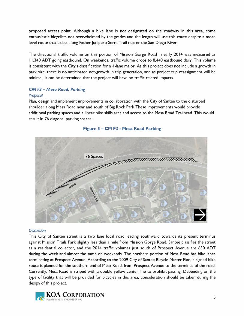
CM F3 – Mesa Road, Parking
Proposal
Plan, design and implement improvements in collaboration with the City of Santee to the disturbed
shoulder along Mesa Road near and south of Big Rock Park These improvements would provide
additional parking spaces and a linear bike skills area and access to the Mesa Road Trailhead. This would
result in 76 diagonal parking spaces.
Figure 5 – CM F3 - Mesa Road Parking
Discussion
This City of Santee street is a two lane local road leading southward towards its present terminus
against Mission Trails Park slightly less than a mile from Mission Gorge Road. Santee classifies the street
as a residential collector, and the 2014 traffic volumes just south of Prospect Avenue are 630 ADT
during the week and almost the same on weekends. The northern portion of Mesa Road has bike lanes
terminating at Prospect Avenue. According to the 2009 City of Santee Bicycle Master Plan, a signed bike
route is planned for the southern end of Mesa Road, from Prospect Avenue to the terminus of the road.
Currently, Mesa Road is striped with a double yellow center line to prohibit passing. Depending on the
type of facility that will be provided for bicycles in this area, consideration should be taken during the
design of this project.
76 Spaces

6
The City of San Diego Navajo Community Plan had envisioned Lake Murray Boulevard continuing to the
north from San Diego and down the hill into Santee to make a connection with Mesa Road, but this is
inconsistent with Santee’s circulation planning, and there is no active plan to effect this change. Perhaps a
future update of the Navajo Community Circulation Plan will rectify this inconsistency. As this project
does not include a growth in park size, there is no anticipated net-growth in trip generation, and as
project trip reassignment will be minimal, it can be determined that the project will have no traffic
related impacts.
MG F6 – Father Junipero Serra Trail, Parking
Proposal
Construct a 80 space parking lot on the easterly side of Father Junipero Serra Trail between Mission
Gorge Road and the Visitor and Interpretive Center driveway entrance. The existing on-street parking
is assumed to be retained.
Figure 6 – MG F6 - Father Junipero Serra Trail Parking
Discussion
Father Junipero Serra Trail extends from Mission Gorge Road on the west near Jackson Drive in the
City of San Diego to eventually rejoin Mission Gorge Road in Santee to the east. Only the first
approximately 600 feet on the western end of the roadway is traversable in two directions and all day
since a gate restricts traffic beyond the visitors center to eastbound traffic during daytime hours as a
one-way roadway. In the 600 foot, two-way portion the roadway is two lanes, approximately 36 feet
wide, and parking is allowed along much of it. A rounded, semicircular spot exists in the roadway on the
east side where additional street parking is available perpendicular to the roadway. In total there are
approximately 50 on-street parking spaces in this stretch between Mission Gorge Rd and the Visitors
80 Spaces

7
Center access driveway. During peak times on weekends most of these spaces are occupied; with the
construction of this project, visitors would have the option of using the new 80 space lot.
Access is gained to and from Mission Gorge Road via a right turn in or out from westbound Mission
Gorge Road or from a median break allowing left turns in only from Mission Gorge Road. Exiting turns
are not allowed left or easterly onto Mission Gorge Road as there is no traffic signal, and the speeds
would make that turn infeasible without a signal. Recent 2014 traffic counts show that the weekday
traffic is 2,190 ADT (both directions) and it rises to 3,500 on a weekend day between Mission Gorge
Road and the Visitors Center. As this project does not include a growth in park size, there is no
anticipated net-growth in trip generation, and as project trip reassignment will be minimal, it can be
determined that the project will have no traffic related impacts.

Attachment A: Traffic Counts
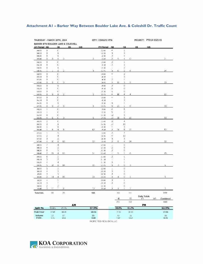
Attachment A1 – Barker Way Between Boulder Lake Ave. & Coleshill Dr. Traffic Count
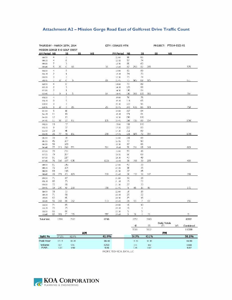
Attachment A2 – Mission Gorge Road East of Golfcrest Drive Traffic Count
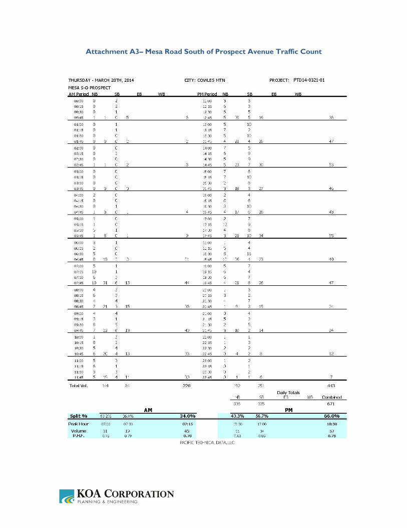
Attachment A3– Mesa Road South of Prospect Avenue Traffic Count

Attachment A4 – Father Juipero Serra Trail North of Mission Gorge Road Traffic Count