Embed Size (px)
Citation preview
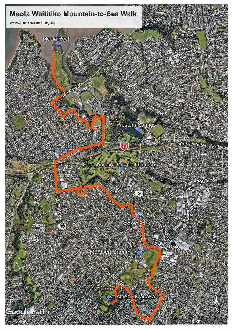
Meola Waititiko Mountain-to-Sea Walk www.meolacreek.org.nz
1 km
N
➤➤
N© 2018 Google
© 2018 Google
© 2018 Google
Meola Waititiko Mountain to Sea Walk
Meola Creek Waititiko has the largest catchment of any stream on the Auckland isthmus,
and while its a great feature, its also at risk. To learn more, visit: www.meolacreek.org.nz
The Meola Waititiko "Mountain to Sea" walkway beings at Mt Albert Owairaka and follows,
as closely as possible, Meola Creek Waititiko, until it reaches Meola Reef Te Tokaroa where
the creek meets the Waitemata Harbour.
As some of the creek is currently culverted, and more is difficult to access, the walkway
follows roadways in part. As STEPS is working toward more of the creek being accessible
and restoring its natural state, the aspiration is that the walkway will improve over time,
and become more tightly connected to the Meola Waititiko's journey from "Mountain to
Sea".
Stage 1. Mt Albert Owairaka to Meola Creek Waititiko in Kerr Taylor Reserve
1. Begin at the trig station on Mt Albert Owairaka
2. Follow the path on the crater rim heading west and curving to north next to the road
until you reach the road entrance to the dog exercise / archery area
3. Go down the pathway to Toroa Tce and down to the hill to turn right onto Mt Albert
Road
4. Follow Mt Albert Road until turning left on Euston Road
5. Follow Euston Road until the end and turn left onto Haverstock Road
6. The first street on your left is Ti Kouka Lane, turn left here. As Ti Kouka Lane curves
to the right, it joins the headwaters of the Meola Waititiko. In summer and during
other dry periods, this part of the stream is often dry.
7. Follow Ti Kouka Lane until it re-joins Haverstock Road and turn left.
8. Go around the big bend until you reach the entrance to Kerr Taylor Reserve
9. Walk through the Reserve to the bridge where you meet the stream proper for the
first time.
Stage 2. Kerr Taylor Reserve to Rawalpindi Reserve
1. From the bridge walk down the path on right side of the stream, into the Roy
Clements Treeway, and follow the Treeway to Alberton Ave. At this point the creek
goes into a culvert that flows north under Alberton Ave. The next section of the walk
will approximately follow the culvert’s path.
2. Turn right into Alberton and walk down to the intersection with New North Road.
3. Cross New North Road into Rocket Park and approach the War Memorial Hall.
4. Pass the hall on the left-hand side, and proceed through the upper car park (with the
YMCA on your right) and down to the lower car park.
5. A path to the north leads down off the carpark and on to the lowest part of the park.
6. Once at the bottom of the steps, follow the wide concrete path. This path is actually
the top of the box culvert that Meola Creek runs within.
7. Follow this path until you reach a T junction, and turn left up the slope until you
reach Asquith Ave. This will lead you away from the culverted creek, and it will
remain about 100m to your right for the next section of the walk.
8. Turn left into Asquith Ave, then right into Rossgrove Tce and follow it until the end
9. Turn right into Martin Ave and almost immediately left into Verona Ave and follow it
until the end
10. Turn right into Norgrove Ave and walk to the end, where the creek can be seen
flowing through Norgrove Reserve. If you walk down the path in Norgrove Reserve
you reach the point where the creek comes back out of the culvert.
11. Return back down Norgrove Ave and turn right into Chatham Ave. The creek can be
seen on the right again where Chatham Ave meets Parkdale Road.
12. Turn left into Parkdale Road.
13. Turn right into Fontenoy Street, and then first right into Rawalpindi Street.
14. Rawalpindi Reserve is on the right-hand side and provides access to the creek before
it crosses Chamberlain Park Golf Course.
Stage 3. Rawalpindi Reserve to Meola Reef Te Tokaroa
1. Return to Rawalpindi Street, follow it north and turn left into Segar Ave and follow it
until the end.
2. Turn right into Carrington Road
3. After crossing the bridge over the motorway, turn right into Great North Road.
4. Follow Great North Road for some time, but shortly after passing Premier Road on
the left-hand side, look for a bridge that crosses the creek 30m before reaching
Motions Road.
5. Turn left into Motions Road and walk the left-hand footpath until reaching a path to
a wooden footbridge. Cross this footbridge over the stream and follow the path to
the right on the far side around the Pasadena Intermediate School and turn right to
take the path up to Premier Road and follow it until the roundabout at the far end.
6. On the far side of the roundabout walk down the path to the reserve at the far end.
The creek is at the bottom of the slope of the reserve.
7. Follow the path up to Moa Road and turn right.
8. When you reach the end of Moa Road, turn right onto Meola Road and, after
100metres, cross over the creek on the road bridge, and just past the bridge is a path
into Meola Reef Reserve.
9. Walk through the park, keeping to the paths following as close as possible to the
creek and still going roughly north until you reach the northern edge of the park.
10. In front of you is Meola Reef Te Tokaroa, and to your left is where Meola Creek
meets the Waitemata harbour. Sit and enjoy the view, you have earned it!