Embed Size (px)
Citation preview
MERRIFIELD ROAD AND I-29INTERCHANGE JUSTIFICATION
REPORTGRAND FORKS, NORTH DAKOTA
Submitted toGrand Forks/East Grand Forks MPO
Submitted by
October 3, 2002
INTERCHANGE JUSTIFICATION REPORT
Merrifield Road and I-29
Grand Forks, North Dakota
October 3, 2002
Submitted To:
Grand Forks/East Grand Forks MPO
Submitted By:
HWS CONSULTING GROUP INC.
Interchange Justification ReportExecutive Summary
The Grand Forks-East Grand Forks Metropolitan Planning Organization (MPO) isinterested in studying the potential benefits and impacts of an interchange on I-29 atMerrifield Road. Currently, Merrifield Road is an overpass at I-29. The nearestinterchanges are at 32nd Avenue South in Grand Forks and at the Thompson Exit south ofMerrifield Road.
The Federal Highway Administration and North Dakota Department of Transportationhave strict guidelines for determining whether or not new interchanges on the interstatesystem are needed and feasible. The eight (8) criteria are summarized below:
1. Are the existing roads and interchanges congested or will be during the design year?
Currently, both the Thompson Interchange and the 32nd Avenue SouthInterchange operate at an acceptable level of service. Both of these interchangesare expected to still operate at an acceptable level of service with the 2025projected traffic volumes. However, with 2025 traffic volumes, some intersectionsalong 32nd Avenue South are expected to experience unacceptable level of servicebetween I-29 and Washington Street and a couple of the individual movementlevel of service at the I-29 and 32nd Avenue South interchange operate at a levelof service ‘D’. These results of this analysis are illustrated in Figure 3-2.
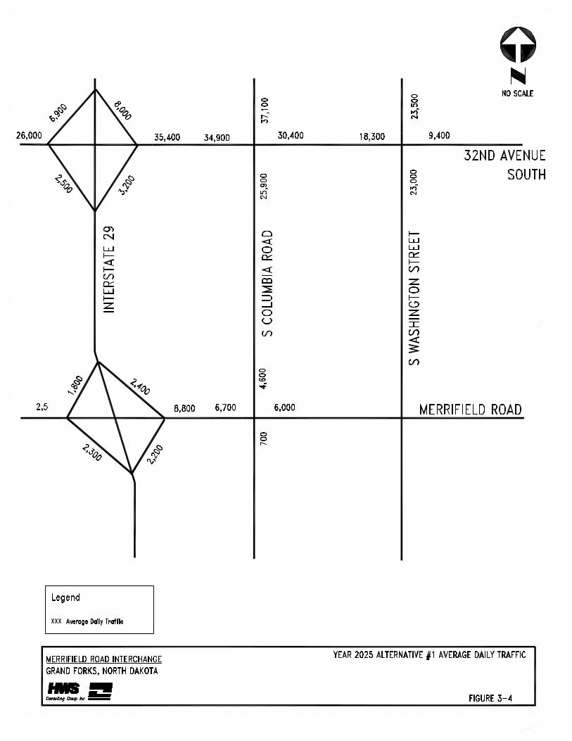
With the proposed interchange at Merrifield Road, it reduces the traffic volumesalong 32nd Avenue South by approximately 10% which reduces the expectedaverage delay along this corridor. The projected average daily traffic volumesare illustrated in Figures 3-1 and 3-4.
2. Were all reasonable alternatives evaluated?
After reviewing the other locations for a possible interchange to address theconcerns for safety, congestion, user costs and I-29 traffic flow, it was determinedthat the Merrifield Road location was the best location. This was due to thebusinesses already in this area and potential for new businesses and theirrequirement for significant truck access. Also, this location was spaced farenough away from the Thompson interchange and the 32nd Avenue Southinterchange that it does not adversely affect the I-29 traffic. Section 3.2 providesa detailed discussion about the alternative analysis.
3. Will the new interchange have adverse effects?
The new interchange does not adversely affect I-29. A merge analysis wasconducted and the results indicated that the merge level of service rangedbetween level of service A to B. Table 3-2, on page 3-9 summarizes the resultsfrom the merge analysis.
4. Will there be connections only to public roads and provide all movements?
There will only be connections made to Merrifield Road and the ramp terminalswill provide access to all movements. Figure 3-3 provides an illustrationdepicting the proposed interchange configuration.
5. Will this project be coordinated with other transportation improvements?
This project will be coordinated with the improvements recommended in the longrange transportation plan update, which is currently being updated.
6. Is this consistent with metropolitan and statewide transportation plan?
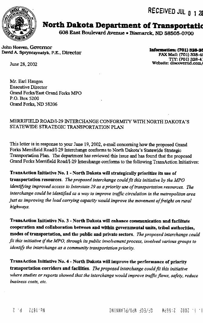
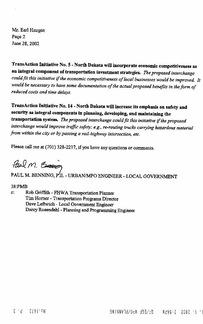
The North Dakota Department of Transportation has reviewed this issue and hasfound that the proposed Grand Forks Merrifield Interchange conforms with theStatewide Strategic Transportation Plan. A detailed description of the conformityis attached in the appendix of this report.
The Grand Forks/East Grand Forks Metropolitan Planning Agency amendedtheir long range transportation plan to include an interchange at Merrifield Roadand Interstate 29. The minutes from these meetings are attached in the appendixof this report.
7. Are there potential environmental impacts?
A study of the Merrifield Road and I-29 intersection was performed to identifyany hazardous waste sites and to determine the probability of environmentalcontamination resulting from disturbance of any identified sites. This involved asearch of state and federal environmental records. The search was performed byan environmental database service and conformed to the American Society ofTesting and Materials (ASTM) standards for environmental studies.
Sites within a one-mile radius of the project were analyzed. No potentialhazardous waste sites were identified in the project area. Section 2.3, on page 2-2 discusses the existing environmental constraints.
8. Was there appropriate documentation of planning and environmental process?
As a part of this process there was a meeting with the properties owners in thearea and their comments are contained in the appendix of this report. Also, inMay 2002, over 50 letters were sent out soliciting information from utilitycompanies and public agencies regarding potential impacts to their facilities if aninterchange were constructed at Merrifield Road. A summary of their commentsis contained in the appendix of this report.
In addition to the property owner meetings, both Grand Forks and East GrandForks planning committees approved the project. Minutes from those meetingsare included in the appendix of the this report.
Therefore, due to the fact the interchange does not adversely affect the I-29 traffic andprovides many safety and user cost benefits, it is recommended to construct aninterchange at the existing overpass of I-29 and Merrifield Road.
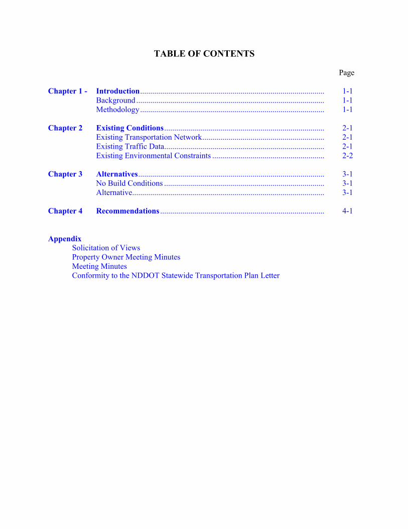
TABLE OF CONTENTS
Page
Chapter 1 - Introduction............................................................................................ 1-1Background .............................................................................................. 1-1Methodology............................................................................................ 1-1
Chapter 2 Existing Conditions................................................................................ 2-1Existing Transportation Network............................................................. 2-1Existing Traffic Data................................................................................ 2-1Existing Environmental Constraints ........................................................ 2-2
Chapter 3 Alternatives............................................................................................. 3-1No Build Conditions ................................................................................ 3-1Alternative................................................................................................ 3-1
Chapter 4 Recommendations .................................................................................. 4-1
AppendixSolicitation of ViewsProperty Owner Meeting MinutesMeeting MinutesConformity to the NDDOT Statewide Transportation Plan Letter
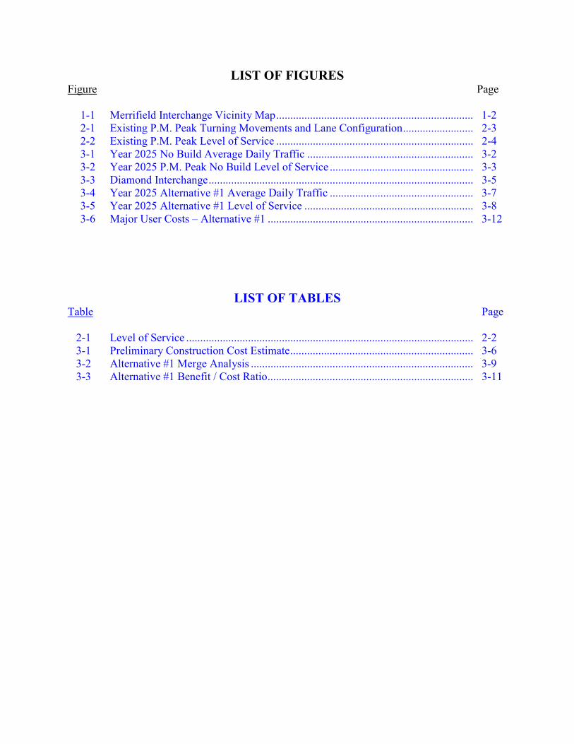
LIST OF FIGURESFigure Page
1-1 Merrifield Interchange Vicinity Map...................................................................... 1-22-1 Existing P.M. Peak Turning Movements and Lane Configuration......................... 2-32-2 Existing P.M. Peak Level of Service ...................................................................... 2-43-1 Year 2025 No Build Average Daily Traffic ........................................................... 3-23-2 Year 2025 P.M. Peak No Build Level of Service ................................................... 3-33-3 Diamond Interchange.............................................................................................. 3-53-4 Year 2025 Alternative #1 Average Daily Traffic ................................................... 3-73-5 Year 2025 Alternative #1 Level of Service ............................................................ 3-83-6 Major User Costs – Alternative #1 ......................................................................... 3-12
LIST OF TABLESTable Page
2-1 Level of Service ...................................................................................................... 2-23-1 Preliminary Construction Cost Estimate................................................................. 3-63-2 Alternative #1 Merge Analysis ............................................................................... 3-93-3 Alternative #1 Benefit / Cost Ratio......................................................................... 3-11
HWS Consulting Group Inc. Grand Forks/East Grand Forks MPOMerrifield Road and I-29 Interchange Feasibility Report
1-1
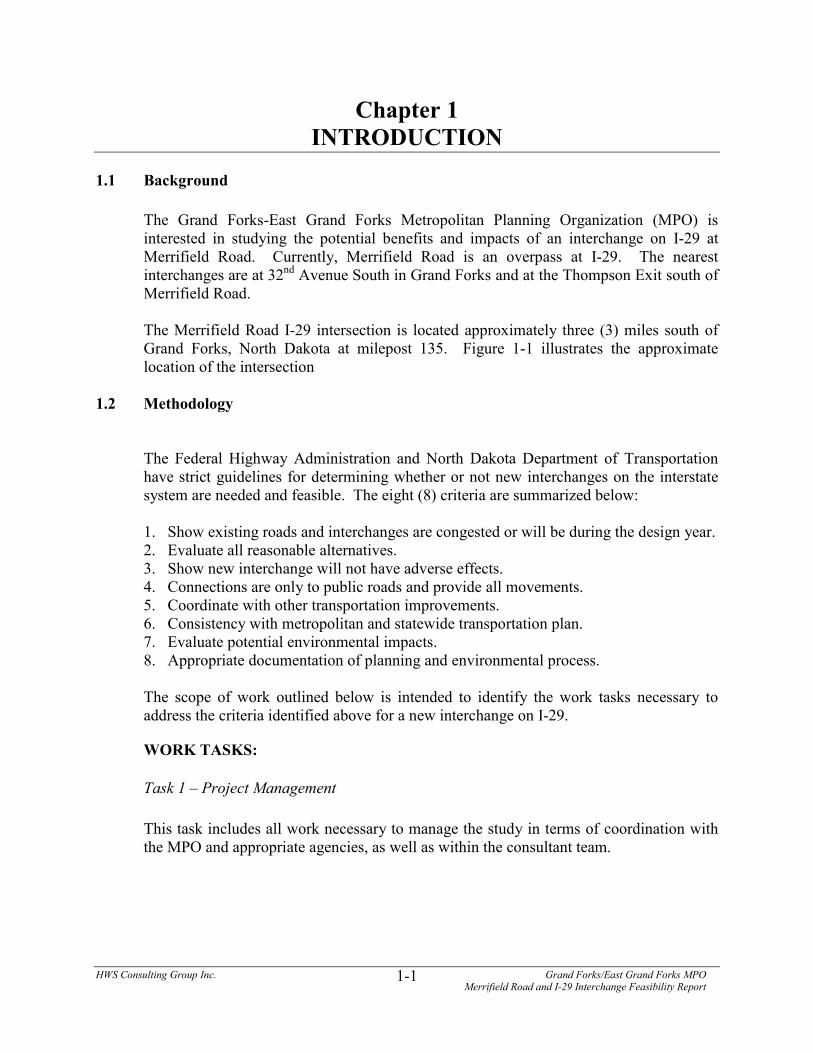
Chapter 1INTRODUCTION
1.1 Background
The Grand Forks-East Grand Forks Metropolitan Planning Organization (MPO) isinterested in studying the potential benefits and impacts of an interchange on I-29 atMerrifield Road. Currently, Merrifield Road is an overpass at I-29. The nearestinterchanges are at 32nd Avenue South in Grand Forks and at the Thompson Exit south ofMerrifield Road.
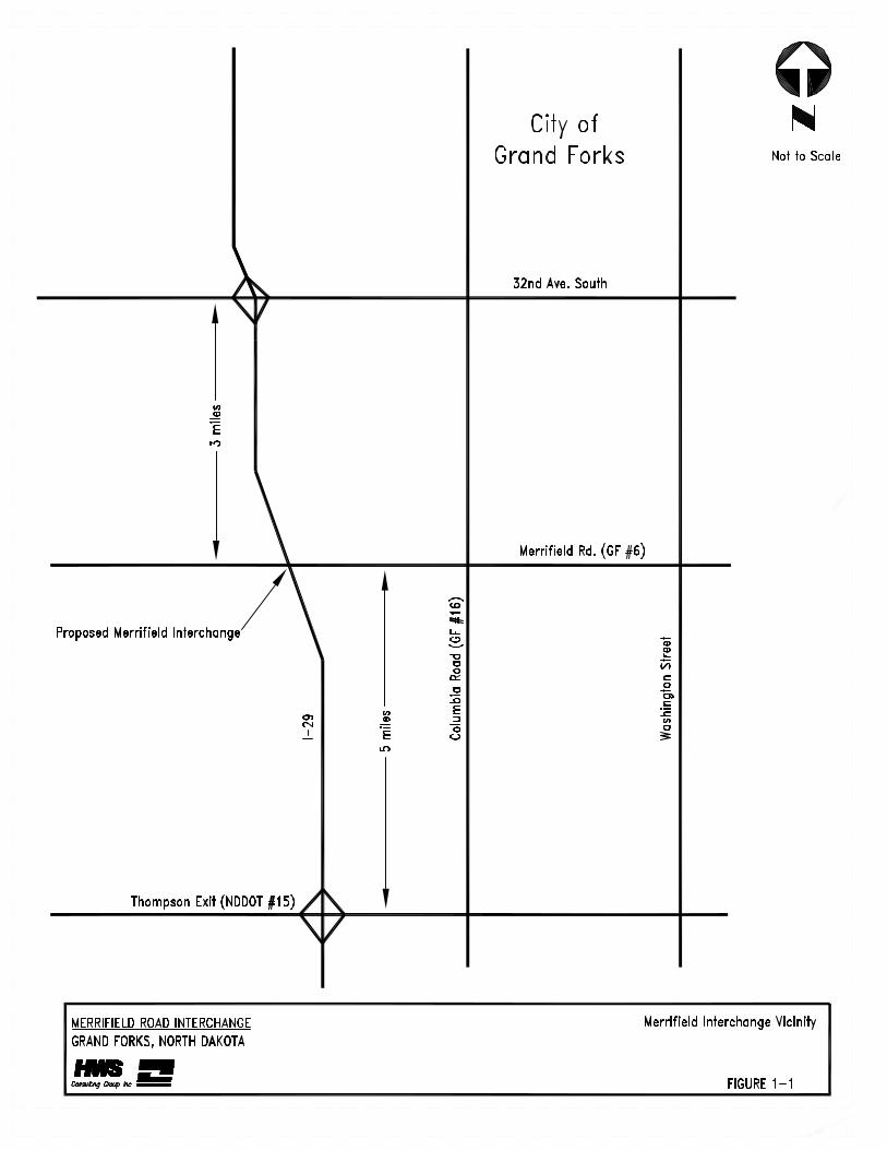
The Merrifield Road I-29 intersection is located approximately three (3) miles south ofGrand Forks, North Dakota at milepost 135. Figure 1-1 illustrates the approximatelocation of the intersection
1.2 Methodology
The Federal Highway Administration and North Dakota Department of Transportationhave strict guidelines for determining whether or not new interchanges on the interstatesystem are needed and feasible. The eight (8) criteria are summarized below:
1. Show existing roads and interchanges are congested or will be during the design year.2. Evaluate all reasonable alternatives.3. Show new interchange will not have adverse effects.4. Connections are only to public roads and provide all movements.5. Coordinate with other transportation improvements.6. Consistency with metropolitan and statewide transportation plan.7. Evaluate potential environmental impacts.8. Appropriate documentation of planning and environmental process.
The scope of work outlined below is intended to identify the work tasks necessary toaddress the criteria identified above for a new interchange on I-29.
WORK TASKS:
Task 1 – Project Management
This task includes all work necessary to manage the study in terms of coordination withthe MPO and appropriate agencies, as well as within the consultant team.
HWS Consulting Group Inc. Grand Forks/East Grand Forks MPOMerrifield Road and I-29 Interchange Feasibility Report
1-3
Task 2 – Public Involvement
This task includes all of the activities involved in meeting with the general public andadjacent property owners. It includes the dissemination of information as well ascollecting information from stakeholders.
Task 3 – Data Collection
This task involves collecting traffic data as well as physical information including maps,utilities, aerial photography, known environmental features and other informationnecessary to fully understand the key issues surrounding the potential Merrifieldinterchange.
Task 4 – Traffic Engineering/Transportation Planning
This task includes the development of P.M. peak hour turning movements using existingturning movements at key intersections in the study area and traffic projections providedby the MPO’s Travel Demand Model. The task also includes an analysis of keyintersections for the determination of future deficiencies and possible mitigationtechniques.
Task 5 – Alternative Development and Evaluation
This task involves a comparison of the costs and impacts of the no-build and alternativeimprovement options to the construction of the Merrifield Road/I-29 interchange.
Task 6 – Environmental Review
This task includes activities involved with the review of the existing environmentalfeatures within the proposed interchange area. A review of all known environmentalfeatures will be conducted to determine the impacts and potential mitigation toconstruction of an interchange.
Task 7 – Project Documentation
This task includes the preparation of all monthly progress reports as well as the Draft andFinal Interchange Feasibility Report.
HWS Consulting Group Inc. Grand Forks/East Grand Forks MPOMerrifield Road and I-29 Interchange Feasibility Report
2-1
Chapter 2EXISTING CONDITIONS
In the vicinity of the Merrifield Road and I-29 intersection it is mostly agricultural with someindustrial uses. Some residential exists approximately ½ mile to the east of the proposedinterchange on Merrifield Road. Two businesses base their operations within the area of theproposed interchange. Ag Depot is located in the southwest corner of the project area and over110 trucks per day use the facility. Telpro is located in the northwest corner of the project areaand also has significant truck traffic. Both businesses have plans for future expansion in theproject area.
2.1 Existing Transportation Network
Interstate 29 is an interstate freeway serving north/south travel throughout the UnitedStates. It has been identified by congress as a corridor of high priority. In the vicinity ofGrand Forks, I-29 is a 4-lane median divided roadway with paved shoulder along theinside and outside edges. The posted speed limit is 70 mph. Merrifield Road (GFCounty Road #6) is a two lane paved roadway which serves east/west travel south ofGrand Forks. It is currently a 2-lane roadway with a posted speed limit of 55 mph.Merrifield Road junctions South 42nd Street on the west side of the interstate, and SouthColumbia Road (GF County #16) on the east side of the interstate. These junctions arestop controlled in the north-south direction. 42nd Street is a gravel township road that issigned restricting loaded truck traffic. The loaded truck traffic must use WashingtonStreet (Hwy 81) which is 2 miles east of South 42nd Street.
The two (2) closest interchanges to this intersection are the 32nd Avenue Southinterchange and the Thompson interchange. The 32nd Avenue South interchange islocated three miles to the north of the proposed interchange, and is a standard urbandiamond design with each of the ramp termini being signalized at 32nd Avenue South.32nd Avenue South is a 4-lane roadway with exclusive left and right turn lanes onto eachramp. The posted speed limit on 32nd Avenue South is 40 mph. Both on/off rampterminals at the interchange have similar roadway geometry. Both the northbound andsouthbound off ramp have an exclusive right turn lane and a shared through/left turn lane,with the southbound ramp having dual lefts. Thompson interchange is located five milesto the south and is a standard rural diamond design.
2.2 Existing Traffic Data
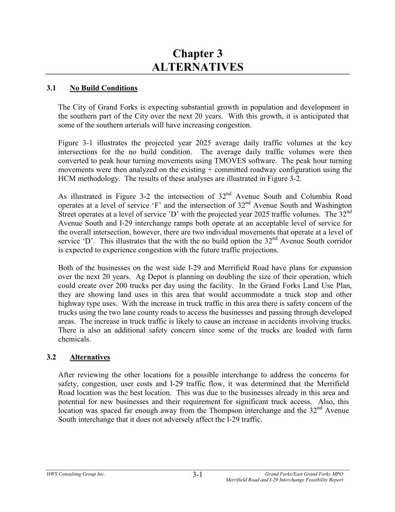
The existing traffic data was provided by the GF/EGF MPO for the affected intersections.They include Merrifield Road and South Columbia Road, 32nd Avenue South and I-29ramps, 32nd Avenue South and South Columbia Road, and 32nd Avenue South and SouthWashington Street. Figure 2-1 illustrates the existing turning movements and laneconfigurations at each intersection.
Capacity analysis at the existing intersections identified above was conducted todetermine the amount of delay currently experienced at these locations. Intersection
HWS Consulting Group Inc. Grand Forks/East Grand Forks MPOMerrifield Road and I-29 Interchange Feasibility Report
2-2
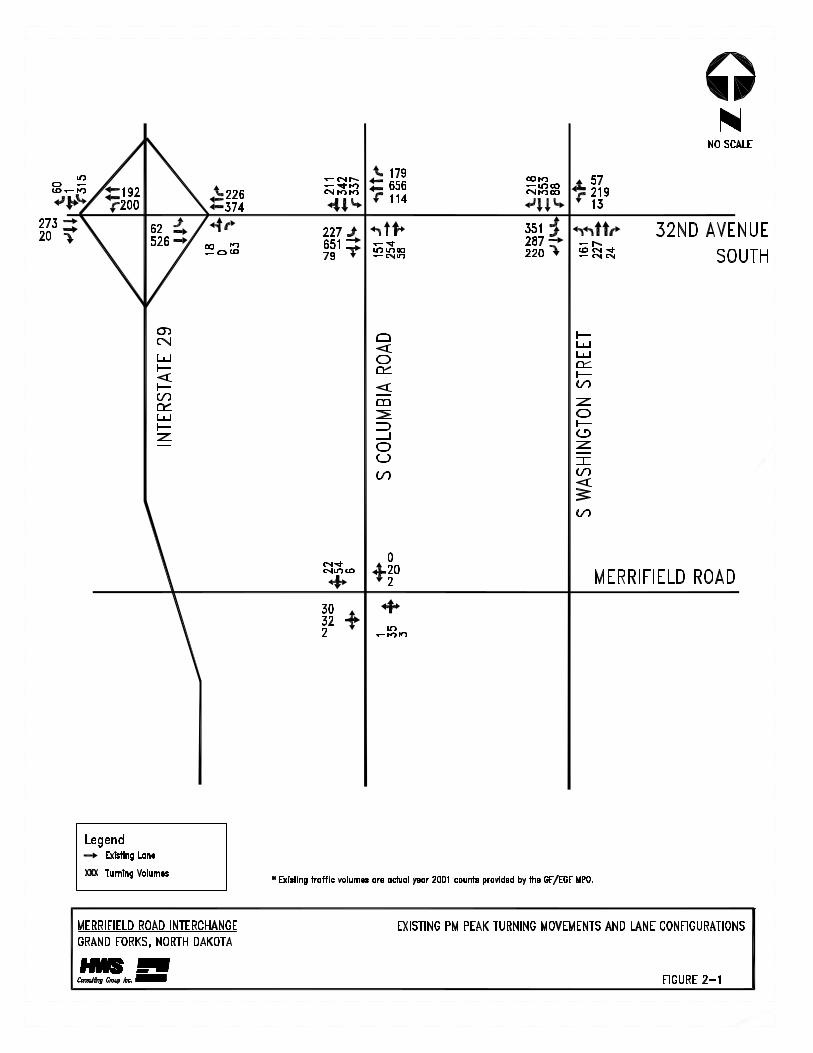
capacities have been analyzed in accordance with the requirements of the 2000 HighwayCapacity Manual (HCM), using the “operations” methodology. The result of such ananalysis is an intersection or movement level of service (LOS), which is a qualitativeassessment of the traffic flow characteristics described by a letter designation rangingfrom A to F. LOS A represents essentially uninterrupted flow with minimal delay, whileLOS F represents breakdown of traffic flow with excessive congestion and delay. LOS Cis generally regarded as the desirable minimum performance level. The level of serviceis determined by the average delay per vehicle at each intersection. Table 2-1 illustratesthe level of service ranges. The results of the analysis are shown in Figure 2-2
There is also extensive truck traffic in this area. The two businesses located on the westside of I-29 and Merrifield Road have significant truck traffic that either uses the 32nd
Avenue interchange or the Thompson interchange. This then requires the trucks to driveover 3 miles on the county roads to access the businesses. The trucks that arrive anddepart from Ag Depot carry placarded farm chemicals and have average loads of30,000 – 40,000 pounds each (A fully loaded truck weighs about 75,000 – 80,000pounds). A majority of the trucks go east on Merrifield Road to Washington Street andthen go north to 32nd Avenue to fuel up before accessing I-29 at the 32nd AvenueInterchange. This provides safety concern due to the high volume of trucks carrying farmchemicals passing through the developed areas of Grand Forks.
2.3 Existing Environmental Constraints
A study of the Merrifield Road and I-29 intersection was performed to identify anyhazardous waste sites and to determine the probability of environmental contaminationresulting from disturbance of any identified sites. This involved a search of state andfederal environmental records. The search was performed by an environmental databaseservice and conformed to the American Society of Testing and Materials (ASTM)standards for environmental studies.
Sites within a one-mile radius of the project were analyzed. No potential hazardouswaste sites were identified in the project area.
Table 2-1 Level of ServiceLOS Delay Range in Seconds
A 0 -10B 11 - 20C 21- 35D 36 - 55E 56 - 80F > 80
HWS Consulting Group Inc. Grand Forks/East Grand Forks MPOMerrifield Road and I-29 Interchange Feasibility Report
3-1
Chapter 3ALTERNATIVES
3.1 No Build Conditions
The City of Grand Forks is expecting substantial growth in population and development inthe southern part of the City over the next 20 years. With this growth, it is anticipated thatsome of the southern arterials will have increasing congestion.
Figure 3-1 illustrates the projected year 2025 average daily traffic volumes at the keyintersections for the no build condition. The average daily traffic volumes were thenconverted to peak hour turning movements using TMOVES software. The peak hour turningmovements were then analyzed on the existing + committed roadway configuration using theHCM methodology. The results of these analyses are illustrated in Figure 3-2.
As illustrated in Figure 3-2 the intersection of 32nd Avenue South and Columbia Roadoperates at a level of service ‘F’ and the intersection of 32nd Avenue South and WashingtonStreet operates at a level of service ’D’ with the projected year 2025 traffic volumes. The 32nd
Avenue South and I-29 interchange ramps both operate at an acceptable level of service forthe overall intersection, however, there are two individual movements that operate at a level ofservice ‘D’. This illustrates that the with the no build option the 32nd Avenue South corridoris expected to experience congestion with the future traffic projections.
Both of the businesses on the west side I-29 and Merrifield Road have plans for expansionover the next 20 years. Ag Depot is planning on doubling the size of their operation, whichcould create over 200 trucks per day using the facility. In the Grand Forks Land Use Plan,they are showing land uses in this area that would accommodate a truck stop and otherhighway type uses. With the increase in truck traffic in this area there is safety concern of thetrucks using the two lane county roads to access the businesses and passing through developedareas. The increase in truck traffic is likely to cause an increase in accidents involving trucks.There is also an additional safety concern since some of the trucks are loaded with farmchemicals.
3.2 Alternatives
After reviewing the other locations for a possible interchange to address the concerns forsafety, congestion, user costs and I-29 traffic flow, it was determined that the MerrifieldRoad location was the best location. This was due to the businesses already in this area andpotential for new businesses and their requirement for significant truck access. Also, thislocation was spaced far enough away from the Thompson interchange and the 32nd AvenueSouth interchange that it does not adversely affect the I-29 traffic.
HWS Consulting Group Inc. Grand Forks/East Grand Forks MPOMerrifield Road and I-29 Interchange Feasibility Report
3-4
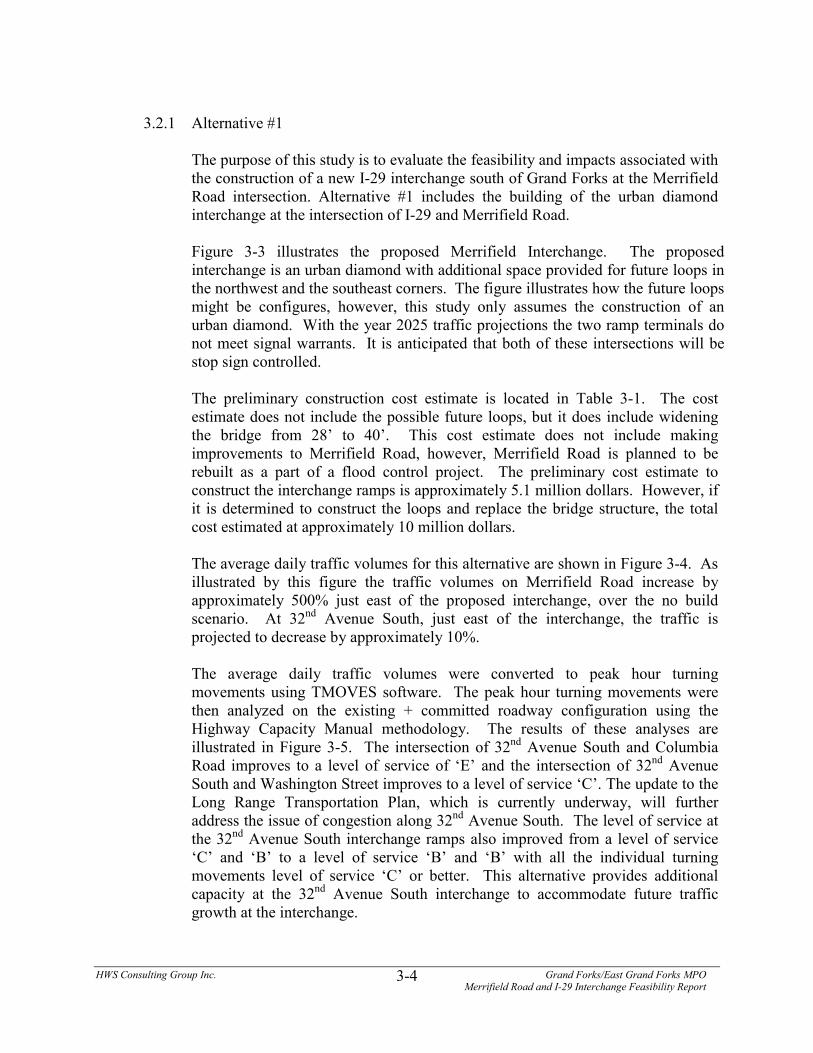
3.2.1 Alternative #1
The purpose of this study is to evaluate the feasibility and impacts associated withthe construction of a new I-29 interchange south of Grand Forks at the MerrifieldRoad intersection. Alternative #1 includes the building of the urban diamondinterchange at the intersection of I-29 and Merrifield Road.
Figure 3-3 illustrates the proposed Merrifield Interchange. The proposedinterchange is an urban diamond with additional space provided for future loops inthe northwest and the southeast corners. The figure illustrates how the future loopsmight be configures, however, this study only assumes the construction of anurban diamond. With the year 2025 traffic projections the two ramp terminals donot meet signal warrants. It is anticipated that both of these intersections will bestop sign controlled.
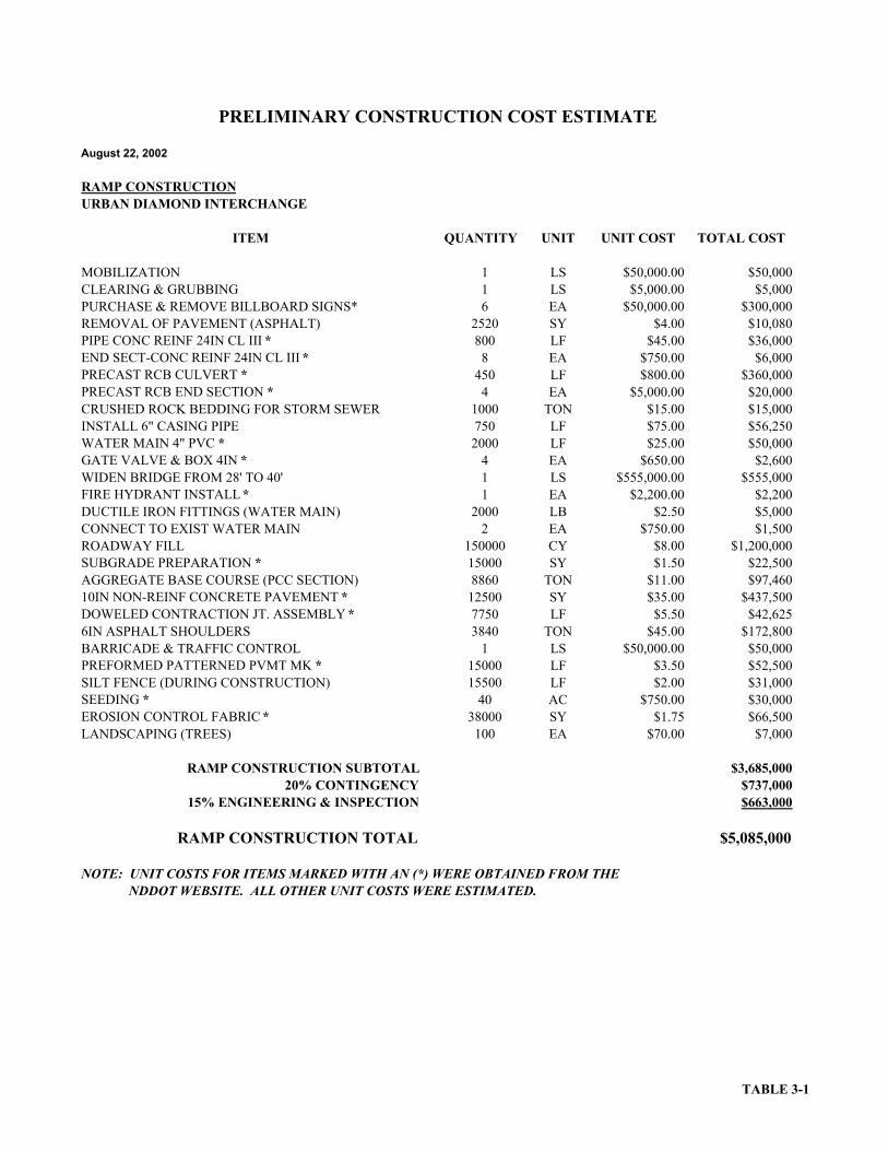
The preliminary construction cost estimate is located in Table 3-1. The costestimate does not include the possible future loops, but it does include wideningthe bridge from 28’ to 40’. This cost estimate does not include makingimprovements to Merrifield Road, however, Merrifield Road is planned to berebuilt as a part of a flood control project. The preliminary cost estimate toconstruct the interchange ramps is approximately 5.1 million dollars. However, ifit is determined to construct the loops and replace the bridge structure, the totalcost estimated at approximately 10 million dollars.
The average daily traffic volumes for this alternative are shown in Figure 3-4. Asillustrated by this figure the traffic volumes on Merrifield Road increase byapproximately 500% just east of the proposed interchange, over the no buildscenario. At 32nd Avenue South, just east of the interchange, the traffic isprojected to decrease by approximately 10%.
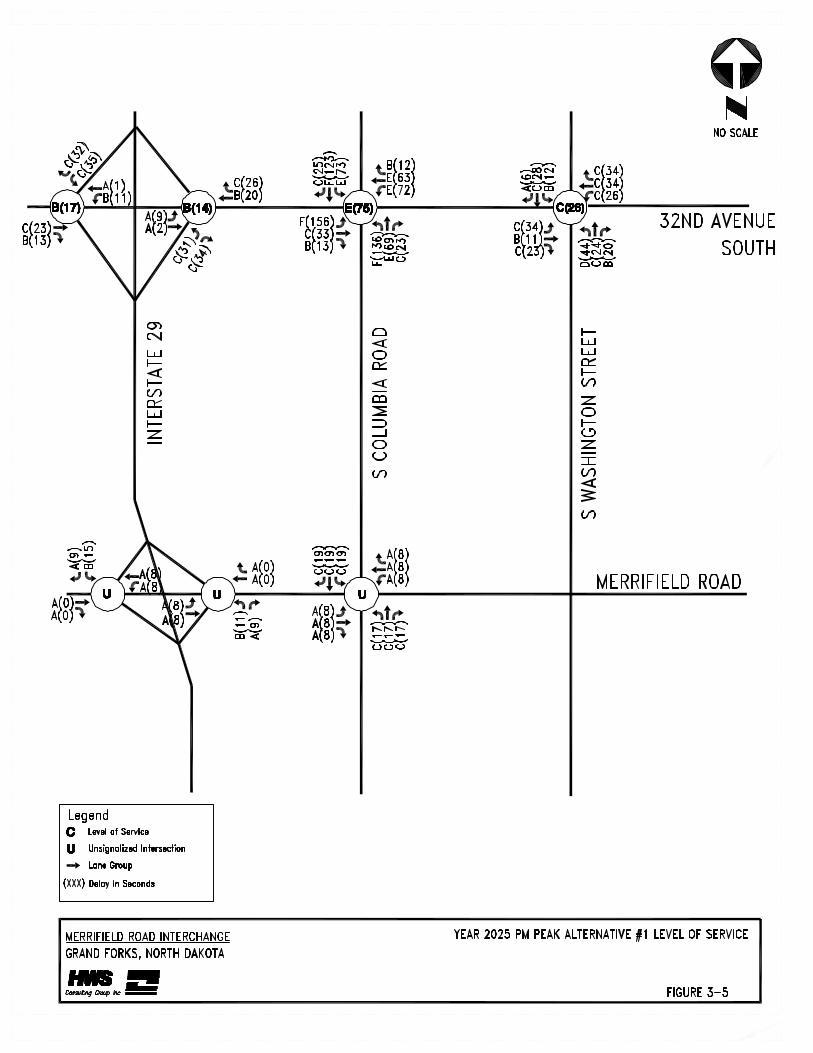
The average daily traffic volumes were converted to peak hour turningmovements using TMOVES software. The peak hour turning movements werethen analyzed on the existing + committed roadway configuration using theHighway Capacity Manual methodology. The results of these analyses areillustrated in Figure 3-5. The intersection of 32nd Avenue South and ColumbiaRoad improves to a level of service of ‘E’ and the intersection of 32nd AvenueSouth and Washington Street improves to a level of service ‘C’. The update to theLong Range Transportation Plan, which is currently underway, will furtheraddress the issue of congestion along 32nd Avenue South. The level of service atthe 32nd Avenue South interchange ramps also improved from a level of service‘C’ and ‘B’ to a level of service ‘B’ and ‘B’ with all the individual turningmovements level of service ‘C’ or better. This alternative provides additionalcapacity at the 32nd Avenue South interchange to accommodate future trafficgrowth at the interchange.

August 22, 2002
RAMP CONSTRUCTIONURBAN DIAMOND INTERCHANGE
ITEM QUANTITY UNIT UNIT COST TOTAL COST
MOBILIZATION 1 LS $50,000.00 $50,000CLEARING & GRUBBING 1 LS $5,000.00 $5,000PURCHASE & REMOVE BILLBOARD SIGNS* 6 EA $50,000.00 $300,000REMOVAL OF PAVEMENT (ASPHALT) 2520 SY $4.00 $10,080PIPE CONC REINF 24IN CL III * 800 LF $45.00 $36,000END SECT-CONC REINF 24IN CL III * 8 EA $750.00 $6,000PRECAST RCB CULVERT * 450 LF $800.00 $360,000PRECAST RCB END SECTION * 4 EA $5,000.00 $20,000CRUSHED ROCK BEDDING FOR STORM SEWER 1000 TON $15.00 $15,000INSTALL 6" CASING PIPE 750 LF $75.00 $56,250WATER MAIN 4" PVC * 2000 LF $25.00 $50,000GATE VALVE & BOX 4IN * 4 EA $650.00 $2,600WIDEN BRIDGE FROM 28' TO 40' 1 LS $555,000.00 $555,000FIRE HYDRANT INSTALL * 1 EA $2,200.00 $2,200DUCTILE IRON FITTINGS (WATER MAIN) 2000 LB $2.50 $5,000CONNECT TO EXIST WATER MAIN 2 EA $750.00 $1,500ROADWAY FILL 150000 CY $8.00 $1,200,000SUBGRADE PREPARATION * 15000 SY $1.50 $22,500AGGREGATE BASE COURSE (PCC SECTION) 8860 TON $11.00 $97,46010IN NON-REINF CONCRETE PAVEMENT * 12500 SY $35.00 $437,500DOWELED CONTRACTION JT. ASSEMBLY * 7750 LF $5.50 $42,6256IN ASPHALT SHOULDERS 3840 TON $45.00 $172,800BARRICADE & TRAFFIC CONTROL 1 LS $50,000.00 $50,000PREFORMED PATTERNED PVMT MK * 15000 LF $3.50 $52,500SILT FENCE (DURING CONSTRUCTION) 15500 LF $2.00 $31,000SEEDING * 40 AC $750.00 $30,000EROSION CONTROL FABRIC * 38000 SY $1.75 $66,500LANDSCAPING (TREES) 100 EA $70.00 $7,000
RAMP CONSTRUCTION SUBTOTAL $3,685,00020% CONTINGENCY $737,000
15% ENGINEERING & INSPECTION $663,000
RAMP CONSTRUCTION TOTAL $5,085,000
NOTE: UNIT COSTS FOR ITEMS MARKED WITH AN (*) WERE OBTAINED FROM THE NDDOT WEBSITE. ALL OTHER UNIT COSTS WERE ESTIMATED.
PRELIMINARY CONSTRUCTION COST ESTIMATE
TABLE 3-1
HWS Consulting Group Inc. Grand Forks/East Grand Forks MPOMerrifield Road and I-29 Interchange Feasibility Report
3-9
An analysis of the interchange was performed to determine whether theinterchange would degrade the level of service on I-29. Analysis on the mergingsections for each entrance ramp onto I-29 was performed to determine the level ofservice. The Highway Capacity Manual 2000 Exhibit 25-4 lists the densities withthe corresponding level of service. The analysis is based upon the freeway flowapproaching the merge area, the ramp flow, and length of acceleration lane. Table3-2 shows level of service for various lane lengths at each merge area.
Table 3-2Alternative No. 1, Merge Analysis
Merge AreaAccelerationLane Length
(ft)
Level ofService
0 B(10)500 A(7)Southbound I-29
Entrance Ramp 1000 A(4)0 B(11)
500 A(8)Northbound I-29Entrance Ramp 1000 A(5)
As illustrated above, that with the 2025 traffic projections the proposed Merrifieldinterchange merge areas operate at an acceptable level of service.
A weaving analysis was not conducted for the proposed interchange due to the 3mile and the 5 mile spacing between nearest interchanges. Therefore, theproposed interchange does not degrade the level of service on I-29.
An analysis was run using the GF/EGF transportation model to determine thevehicle miles traveled (VMT) and vehicle hours traveled (VHT) with theproposed interchange. These results were then compared to the VMT and VHTfrom the no build model. With the year 2000 traffic volumes there is a savings of3436 daily VMT and a savings of 47 daily VHT, with alternative #1. With theyear 2025 traffic volumes there is an increase of 3182 daily VMT and a savings of551 daily VHT, with alternative #1. The reason there was an increase in vehiclemiles traveled with this alternative was to due to the change in the land use plandue to the interchange at Merrifield Road. With an interchange at MerrifieldRoad, the land use plan assumes additional development in the area of theinterchange which increase the trip length from the existing developed areas ofGrand Forks.
HWS Consulting Group Inc. Grand Forks/East Grand Forks MPOMerrifield Road and I-29 Interchange Feasibility Report
3-10
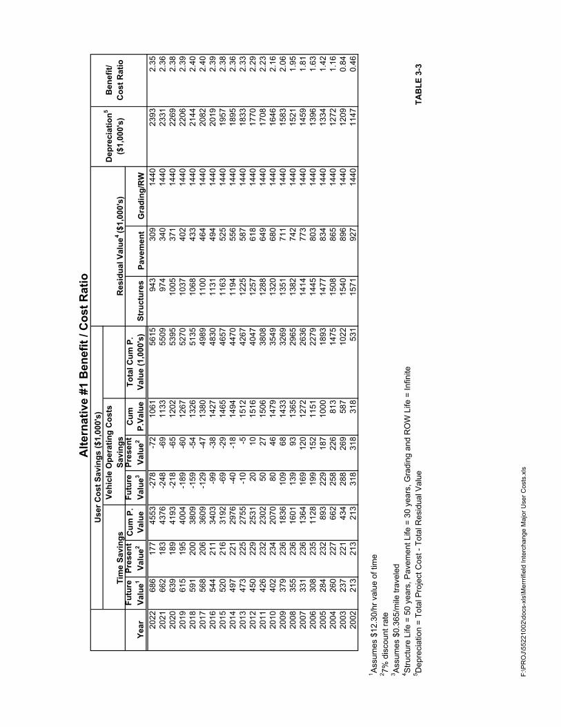
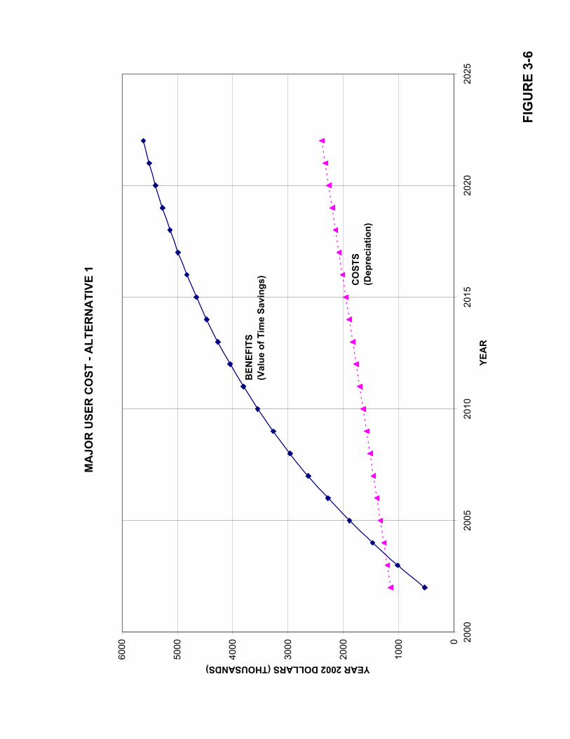
A benefit cost analysis was performed for a 20 year planning horizon. The 20year planning horizon is typical for transportation planning economics. Table 3-3shows the cost savings from year 2002 to year 2022 and also shows the yearlybenefit to cost ratio. As shown in Table 3-3, the total cumulative present value ofthe user cost savings is $5,615,000. Figure 3-6 graphs the benefits versus thecosts for Alternative #1. As illustrated in the graph, after the second yearAlternative #1 has a greater than one (1) benefit to cost ratio. There will also bepossible savings due to the decrease in truck volumes on the county roads and inthe developed areas and the reduced exposure for accidents. These savings aredifficult to quantify but could potentially be significant.
Dep
reci
atio
n5B
enef
it/($
1,00
0's)
Cos
t Rat
io
Year
Futu
re
Valu
e1Pr
esen
t Va
lue2
Cum
P.
Valu
eFu
ture
Va
lue3
Pres
ent
Valu
e2C
um
P.Va
lue
Tota
l Cum
P.
Valu
e (1
,000
's)
Stru
ctur
esPa
vem
ent
Gra
ding
/RW
2022
686
177
4553
-278
-72
1061
5615
943
309
1440
2393
2.35
2021
662
183
4376
-248
-69
1133
5509
974
340
1440
2331
2.36
2020
639
189
4193
-218
-65
1202
5395
1005
371
1440
2269
2.38
2019
615
195
4004
-189
-60
1267
5270
1037
402
1440
2206
2.39
2018
591
200
3809
-159
-54
1326
5135
1068
433
1440
2144
2.40
2017
568
206
3609
-129
-47
1380
4989
1100
464
1440
2082
2.40
2016
544
211
3403
-99
-38
1427
4830
1131
494
1440
2019
2.39
2015
520
216
3192
-69
-29
1465
4657
1163
525
1440
1957
2.38
2014
497
221
2976
-40
-18
1494
4470
1194
556
1440
1895
2.36
2013
473
225
2755
-10
-515
1242
6712
2558
714
4018
332.
3320
1245
022
925
3120
1015
1640
4712
5761
814
4017
702.
2920
1142
623
223
0250
2715
0638
0812
8864
914
4017
082.
2320
1040
223
420
7080
4614
7935
4913
2068
014
4016
462.
1620
0937
923
618
3610
968
1433
3269
1351
711
1440
1583
2.06
2008
355
236
1601
139
9313
6529
6513
8274
214
4015
211.
9520
0733
123
613
6416
912
012
7226
3614
1477
314
4014
591.
8120
0630
823
511
2819
915
211
5122
7914
4580
314
4013
961.
6320
0528
423
289
322
918
710
0018
9314
7783
414
4013
341.
4220
0426
022
766
225
822
681
314
7515
0886
514
4012
721.
1620
0323
722
143
428
826
958
710
2215
4089
614
4012
090.
8420
0221
321
321
331
831
831
853
115
7192
714
4011
470.
46
1 Assu
mes
$12
.30/
hr v
alue
of t
ime
2 7% d
isco
unt r
ate
3 Assu
mes
$0.
365/
mile
trav
eled
4 Stru
ctur
e Li
fe =
50
year
s, P
avem
ent L
ife =
30
year
s, G
radi
ng a
nd R
OW
Life
= In
finite
5 Dep
reci
atio
n =
Tota
l Pro
ject
Cos
t - T
otal
Res
idua
l Val
ueTA
BLE
3-3
Res
idua
l Val
ue4 ($
1,00
0's)
Alte
rnat
ive
#1 B
enef
it / C
ost R
atio
Savi
ngs
Tim
e Sa
ving
s Ve
hicl
e O
pera
ting
Cos
ts
Use
r Cos
t Sav
ings
($1,
000'
s)
F:\P
RO
J\55
2210
02\d
ocs-
xls\
Mer
rrifie
ld In
terc
hang
e M
ajor
Use
r Cos
ts.x
ls
FIG
UR
E 3-
6
MA
JOR
USE
R C
OST
- A
LTER
NA
TIVE
1
0
1000
2000
3000
4000
5000
6000
2000
2005
2010
2015
2020
2025
YEA
R
YEAR 2002 DOLLARS (THOUSANDS)
CO
STS
(Dep
reci
atio
n)
BEN
EFIT
S(V
alue
of T
ime
Savi
ngs)
HWS Consulting Group Inc. Grand Forks/East Grand Forks MPOMerrifield Road and I-29 Interchange Feasibility Report
4-1
Chapter 4RECOMMENDATIONS
The proposed Merrifield and I-29 interchange has many benefits and does not degrade the levelof service along the I-29 corridor. This alternative helps reduce congestion along 32nd AvenueSouth between I-29 and Washington Street. Although, even with this alternative, someintersections along this corridor are over capacity in year 2025, the average delay per vehicle atthese intersections is greatly reduced.
The proposed interchange also helps reduce truck traffic on the county roads. Currently, thetruck traffic that accesses the businesses along the west side of I-29 and Merrifield Road use theinterchanges and 32nd Avenue South and the Thompson interchange. This then requires thetrucks to use county roads and/or urban arterials to access these facilities. Both of the existingbusinesses have plans to expand their operations and in the proposed City of Grand Forks landuse plan they are expecting more businesses to locate in this area. This would greatly increasethe truck traffic in the area. With the high volumes of trucks, with some carrying farmchemicals, using the county roads and passing through the developed areas it creates safetyconcerns and concerns with maintaining the county roads. With an interchange at MerrifieldRoad the trucks would not have to travel through the urban area. This would significantly reducethe exposure rate for possible accidents involving trucks carrying farm chemicals.
This alternative also creates a greater than one benefit cost ratio after the second year. Thesecost savings are due to the savings in vehicle miles traveled and vehicle hours traveled. The netpresent value of these savings over a 20-year period is $5,615,000.
An analysis was conducted to determine if a new interchange at this location would degrade thelevel of service along I-29. Since the closest interchange was 3 miles away from this location aweaving analysis was not conducted. However, a merge analysis was conducted for both of theon ramps and it was determined that the level of service for the merge points ranges from level ofservice A to B, depending on the acceleration lane length. Therefore, this new interchangewould not adversely affect the traffic flow on I-29.
Therefore, due to the fact the interchange does not adversely affect the I-29 traffic and providesmany safety and user cost benefits, it is recommended to construct an interchange at the existingoverpass at I-29 and Merrifield Road.
HWS Consulting Group Inc. Grand Forks/East Grand Forks MPOMerrifield Road and I-29 Interchange Feasibility Report
4-1
Appendix
F:\PROJ\55211014\DOCS-XLS\SOLICITATION OF VIEWS Comments.doc
SOLICITATION OF VIEWS
In May, 2002, over 50 letters were sent out soliciting information from utility companies andpublic agencies regarding potential impacts to their facilities if an interchange were constructedat Merrifield Road. Of those responding, only six (6) had comments that will impact the study.The following summarizes those comments:
1. North Dakota Department of TransportationThe North Dakota Department of Transportation asked that a Class I Cultural ResourceInventory be conducted.
2. City of Grand Forks – Engineering Department� Requested better delineation of drainage facilities, what needs to go with the proposed
design and what needs to be constructed in the future.� Show impacts to existing drains� Show proposed toe of slopes for all fill areas.� The right-of-way appears to be more than what property owners expected.� Identify the design vehicle used for turning radii.
3. City of Grand Forks – Planning Department� Indicated concern over Solicitation of Views letter being sent now rather than with
Project Concept Report.� Cited issues relating to flood protection project, acquisition/relocation of billboards and
modifications to the county road system.
4. NODAK Electric CooperativeNODAK provided information on the existing underground facilities in the area.
5. State Historical Society of North DakotaRequested Section 106 consultations come through FHWA or North Dakota DOT rather thanthe cities of the consultant.
6. North Dakota Department of HealthThey generally think the impacts of constructing the interchange will be minor but providedinformation regarding construction techniques to minimize noise, dust and water qualityproblems.
The results of the Solicitation of Views process indicate that for the most part there are nofacilities in the vicinity that would stop the construction of an interchange. Concerns for utilitiesand other features are typical for a project of this type. The most serious issue is the impact ofthe ongoing flood protection project. The details of this project are currently unknown andtherefore, it is not possible to completely identify mitigation strategies. This information willneed to be determined in greater detail with a development of a Project Concept Report.
F:\PROJ\55211014\DOCS-XLS\Prop Own Mt Minutes 11-8-01.doc 1
MINUTES OFMERRIFIELD ROAD/I-29 INTERCHANGE
PROPERTY OWNER MEETINGNovember 8, 2001, 8:30 A.M.
Grand Forks City Hall, Grand Forks
ATTENDEES:Cindy VoigtRichard OnstadDennis PotterJohn DreesDuane MaatzDave Young
Roland YoungLarry P. YoungCheri ReitmeierJohn EricksonEarl HaugenMike Gorman
PURPOSE:
The Purpose of the meeting was to talk with property owners adjacent to the proposed I-29/Merrifield Road interchange to discuss existing farming and business operations and futureplans for development and/or expansion. This information will be used to estimate existingfuture use of a proposed interchange and it’s impacts on the adjacent roadway system.
DISCUSSION:
� Mike Gorman presented a scaled drawing of a proposed rural type interchange at I-29 andMerrifield Road. The drawing showed the general geometrics of proposed on and off ramps,traffic controls and modifications to the existing Merrifield Road. Mr. Gorman explainedthat the drawing was developed with a rural interchange in mind. If the traffic projectionsindicate that a more urban type interchange will be needed in the future, the proposedinterchange design could change significantly.
� Representatives from Ag Depot discussed their current operation.� They have over 100 employees.� Over 110 trucks per day use the facility.� They are planning a 70,000 sf addition.� They are experiencing a 34% annual growth rate.� They store bulk and package goods.� They currently have a 10,000 sf office with 40 employees.� They are planning over a 20 year time frame. The size of the operation could double in
that time.� Webster, Iowa has a similar site called Vandiest.� The consultant and members of the city and MPO staff were invited to come out and tour
the facility.� Trucks and personnel going to and from the site currently use the Thompson interchange
or 32nd Avenue South interchange.
F:\PROJ\55211014\DOCS-XLS\Prop Own Mt Minutes 11-8-01.doc 2
� 42nd Street is in bad shape and is getting beat up because of the amount of trucks andvehicles using the roadway. Mike Gorman noted that there is an existing load limit signnorth of Merrifield Road on 42nd Street and south of 32nd Avenue South. There is aconcern of the safety of trucks that use this roadway.
� Something needs to be done with the 42nd Street, Columbia, and Merrifield Roadintersections. Some trucks are using the Columbia/Merrifield Road interchange to get tocommercial areas in the southern part of Grand Forks.
� Discussion occurred with the property owner in the northeast corner of the intersection. Heindicated that this is currently being used as farmland, however, it could be a commercial orresidential site in the future.
� Telpro has plans to eventually add on to the south end of the building. Their truck traffic iscurrently using the same route as the Brown Corporation. They currently have 50employees. Ten are at the original facility and they may want to do something with retailoperation in the area immediately in the northwest quadrant of the I-29/Merrifield Roadintersection.
� Southeast corner property owner supports interchange, but something needs to be done withdrainage in the area. This is an important factor that needs to be considered.
� Consultant needs to determine future access points. How close could an access point onMerrifield Road be to potential off-ramps?
� The Corps of Engineers is completing a hydrological study which will be available to theconsultant soon.
� Property owners in the area have petitioned the state and city to look at advancedconstruction of an interchange. They would like to start construction around the year 2003timeframe. They will advance to the State funding for 2003 construction, hoping for2004/2005 fund reimbursement. The most important thing is to get the InterchangeJustification Report (IJE) completed as soon as possible.
� There is a natural gas pipeline in the interchange area. We need to find out about all theutilities in the interchange area as the IJR is completed.
� Nodak Electric Power is also in the interchange area.
� The consultant needs to check with the North Dakota Department of Transportation to findout if the Merrifield Road over I-29 needs to be widened if there is an interchange. Aftermuch discussion it was determined that widening probably would not be necessary.
� The NDDOT has told property owners that the cost of the interchange may be as high as $5.5- $6 million. Mike Gorman said this probably high if the bridge does not need to be replaced.
� Mike Gorman will meet with the North Dakota Department of Transportation to documentthe design criteria.
PROCEEDINGS OF THEEXECUTIVE POLICY BOARD OF THEGRAND FORKS/EAST GRAND FORKS
METROPOLITAN PLANNING ORGANIZATIONFriday, July 12, 2002 – 12:00 Noon
Grand Forks City Hall Conference Room A102
MOTION TO AMEND AGENDA
Grassel reported that a request has been made to amend the agenda to include an additional item:Amendment To The Transportation Plan To Include The Merrifield Road Interchange As AConstruction Project Rather Than Just Corridor Preservation.
Moved by Kweit, seconded by Mattson, to Amend The Agenda To Include An Amendment ToThe Transportation Plan To Include The Merrifield Road Interchange As A ConstructionProject Rather Than Just Corridor Preservation. Motion carried unanimously.
MATTER OF AMENDMENT TO THE LONG RANGE TRANSPORTATION PLAN TOINCLUDE THE MERRIFIELD ROAD INTERCHANGE AS A CONSTRUCTIONPROJECT RATHER THAN JUST CORRIDOR PRESERVATION
Haugen referred to copies of the staff report, which was delivered earlier, and explained that theMPO Executive Policy Board had asked HWS, Inc., to look at a possible Merrifield Interchange,and to prepare an Interchange Justification Report for it. He stated that a DraftInterchange Justification Report, a second draft actually, was prepared and distributed, and isrecommending that an interchange be constructed, with a cost estimate of $4.3 million dollars.
Haugen reported that the current Long Range Transportation Plan calls for just corridorpreservation activity along Merrifield Road, for both an interchange and a future Red RiverBridge. He stated that the request is for the MPO Executive Policy Board to submit, to bothcities, for their plan amendment process, and consideration, to amend their transportation plansto change, at this location, from corridor preservation activities to actual construction. He saidthat this will allow the MPO Executive Policy Board, after they forward recommendations, orafter 60-days, to consider taking final action to amend the MPO’s Long Range TransportationPlan to change the corridor activities at this site to actual construction, which will then allow thatthe final IJR be forwarded to Federal Highway through the NDDOT.
Haugen referred to a copy of the Technical Advisory Committee’ tentative timeline for thisproject, which was attached as part of the staff report, and pointed out that as this goes throughthe local plan amendment process, NDDOT and Bismarck Federal Highway will be providing uswith comments, so we will be involving them along the way, so that, it is hoped, by September11th we will have a document that everyone is comfortable with and easily approved andadopted.
Haugen stated that what we are asking today is for the MPO Executive Policy Board to submit arequest to both cities to consider an amendment to the Long Range Transportation Plan tochange from corridor activities along Merrifield Road and I-29 to construction of an interchange.
Kweit commented that he can report that the Grand Forks Planning Commission gavepreliminary approval to this report at their meeting on Wednesday, July 10th. He said he recallsthat when discussion on this first began, we had to get everything in place by a certain date inorder to get the land donated for the interchange, where does this stand today. Haugenresponded that he doesn’t know if this has changed any, that we are still working towardsmeeting those dates. Potter stated that Brown Corporations is not here today, so he would notpresume to say what their status is on this.
Grassel asked for a brief history on this issue, that he seems to recall that the MerrifieldInterchange was, at one time, included in the Long Range Transportation Plan, then wasremoved because of the bridge issue. Beauchamp said this was correct, that this is the long-and-short of it. Kvasager commented that everyone seemed to think this project was so far out in thefuture, that a bridge would have to be planned and a corridor preserved, before an interchangecould even be considered, but that now some of the business along that corridor feel there is aneed to do this as soon as possible. Mattson mentioned that when this was discussed with theMinnesota delegation, they stated that the interchange would need to be built before a bridgecrossing would even be considered. Haugen said that NDDOT’s perspective was just theopposite.
Beauchamp said he doesn’t want to get hung up on process, that he wants to see it move forward,but he asked if this was something we normally do, change it from corridor preservation to aproject, and then wait for all these drafts. Haugen responded that it was the normal process.
Moved by Kweit, seconded by Beauchamp, To Grant Preliminary Approval To An AmendmentTo The Long Range Transportation Plan To Include The Merrifield Road Interchange As AConstruction Project Rather Than Just Corridor Preservation, And To Submit A Request ToThe Cities Of Grand Forks And East Grand Forks And Grand Forks County To ConsiderAmending Their Transportation Plans As Such. Motion carried unanimously.
PLANNING AND ZONING COMMISSIONMEETING MINUTES
City of Grand Forks, North Dakota
July 10, 2002MERRIFIELD ROAD/I-29 INTERCHANGE
Potter asked the Commission to suspend the rules and introduce a text ordinance toamend the Land Use Plan to add the Merrifield Road/I-29 Interchange to the section inthe Land Use Plan related to the Metropolitan Planning Organization.
Potter referred members to the document titled Merrifield Road and I-29 InterchangeJustification Report. During a meeting with the Technical Advisory Committee of theMetropolitan Planning Organization, the committee arrived at a time schedule ofSeptember 12 for the MPO Policy Board to 1) add the Merrifield Interchange to theexisting long-range transportation plan; and 2) approve the interchange justificationreport and submit to the State of North Dakota. To be able to complete the timeline, thecity has to amend the comprehensive plan to add the Merrifield Interchange and in orderto do that and meet the September 12 deadline, the request is to introduce the textordinance and grant preliminary approval to amend the Land Use Plan. This wouldallow a hearing at the Council of the Whole on July 22, introduce the ordinance at theCity Council meeting on August 5. The final approval by the Planning and ZoningCommission would be on August 7 and the City Council would review for final approvalon August 19, 2002.
MOVED BY DREES AND SECONDED BY GRASSER TO SUSPEND THEAGENDA, INTRODUCE AN ORDINANCE TO AMEND THE LAND USE PLANAND ADD THE MERRIFIELD ROAD/I-29 INTERCHANGE. MOTIONCARRIED UNANIMOUSLY.
(GF City Council)
COMMITTEE OF THE WHOLEMonday, July 22, 2002 - (following special council meeting at 7:00 p.m.)
3.4 Amend Section 18-0802 of the Land Development Code relating to The Grand Forks East Grand Forks 2022 Transportation Plan Update.____________________________________ No comments.
PROCEEDINGS OF THE CITY COUNCILOF THE CITY OF GRAND FORKS, NORTH DAKOTA
August 5, 2002INTRODUCE ORDINANCE AMENDING THE COMPREHENSIVE
PLAN RELATED TO THE GRAND FORKS-EAST GRAND FORKS2022 TRANSPORTATION PLAN UPDATE BY ADDING THEMERRIFIELD ROAD/I-29 INTERCHANGE
The staff report from the Planning Department relating to the request from the Planning Department toamend Section 18-0802 of the Land Development Code related to the Grand Forks-East Grand Forks2022 Transportation Plan Update, with recommendation to introduce an ordinance amending the LandDevelopment Code related to The Grand Forks-East Grand Forks 2022 Transportation Plan Update byadding the Merrifield Road/I-29 Interchange.
Dennis Potter, city planner, asked the council give preliminary introduction and first reading to thisordinance and change the public hearing date from August 19 in the Planning staff report to September 3,2002.
Council Member Glassheim asked status of the interchange - funding, estimated cost and timelines; Mr.Potter stated they are giving approval to adding the Merrifield Road/I-29 Interchange to the City'scomprehensive plan and making a recommendation to the Metropolitan Planning Organization that theytake the same action; the issues of payment will be part of the next round of discussions that go on whenget to the project concept report and look to see how actually funded, the current concept is to try toachieve what's called advance funding and that would lead to a funding package made up of State fundsand local funds, the exact split is still under consideration and will be defined as part of the projectconcept report; and looking to get it done by 2005.
Council Member Glassheim stated he was concerned about the lengthening of the city farther south, andwhat that means to the entire city, and asked if urban sprawl would be created. Mr. Potter stated you arefaced with the fact that you have development in the area where Merrifield Road and I-29 are (Telpro andAgsco) and they are generating a significant amount of traffic, that Agsco is currently using MerrifieldRoad and coming into and out of their facility, going east to Columbia Road and depending on traffic anddestination, going south on Columbia Road getting onto old 81, and going to connector road to Thompsoninterchange and getting on the Interstate or coming north to the city and going to 32nd Avenue South andgetting on the freeway; and this becomes one of the trade-off issues that you look at when doing planningand if want to have that traffic which is going to increase, assuming both companies are successful,coming onto Columbia, etc. or want to have an interchange there that will deal with that traffic (could alsoincrease and have some development occur in that area). He stated there is residential development inthat area which is served by individual septic tank systems and by rural water and question is if there is apolitical will to say no, we are going to draw line in the sand and say no more development of any typesouth of a given line, because when get into urban sprawl; and non-urban sprawl discussion, somewhere apolitical body has to draw a line and say not going to do it. and not easy question.
Council Member Hamerlik stated that several years ago we included the Merrifield Road and the bridgeinto the concept, and this broadens that out to make it more useful. Mr. Potter stated it does and in theoryyou're not going to have a useful bridge over the Red River of the North on Merrifield Road unless youput an interchange at I-29 and Merrifield.
It was moved by Council Member Kreun and seconded by Council Member Christensen to approve therecommended action and to include the change of the public hearing date to September 3, 2002. Carried7 votes affirmative.
Council Member Brooks introduced an ordinance entitled "An ordinance amending theComprehensive Plan, amending Chapter XVIII, Article 8, Comprehensive Plan; Section 18-0802,Elements of the Grand Forks City Code of 1987, as amended, pertaining to the Grand Forks-East
Grand Forks 2022 Transportation Plan Update (2001 Bikeway, 1999 Pedestrian Element; 2002Transit Element, 2001 Street and Highway Element, and 2000 Grand Forks/East Grand Forks ITS
Strategy Plan Element)", which was presented, read and passed on its first reading.
PLANNING AND ZONING COMMISSIONMEETING MINUTES
City of Grand Forks, North DakotaAugust 7, 2002
3-7. (PUBLIC HEARING) MATTER OF THE REQUEST FROM THE PLANNINGDEPARTMENT FOR FINAL APPROVAL OF AN ORDINANCE TO AMENDTHE TEXT OF THE LAND DEVELOPMENT CODE, CHAPTER XVIII OF THEGRAND FORKS CITY CODE OF 1987, AS AMENDED, SECTION 18-0802RELATING TO THE GRAND FORKS-EAST GRAND FORKS 2022TRANSPORTATION PLAN UPDATE.
Potter reviewed the ordinance, stating the ordinance would add an interchange on I-29 atMerrifield Road. This would be added to the plan and recommend to the City Counciland the GF-EGF MPO that they approve the recommendation. Staff recommendation isfor approval.
Hagness asked what happens to the state highway user’s funds for that project. Is it thecity or the county that has to prioritize it?
Potter stated that once it is an approved site and gone through the interchangejustification report and been accepted by the Federal Highway Administration then itgoes into the Project Concept Report phase, this opens a parallel negotiation track withthe state over who will pay and how much of the cost.
Hagness wanted to know where 17th Avenue South and I-29 was involved in thepriority? Potter said that has nothing to do with the Merrifield Interchange because thecity has not approved an interchange on 17th Avenue South/I-29. The state does not havethat under consideration.
Hagness asked if the city or the county could afford an interchange at Merrifield Road.Potter said this was a very serious attempt to do an interchange at Merrifield and I-29 by2005.
Hagness asked where the funds were coming from and Potter said it would be paid bynegotiation process that would involve the state and federal dollars and also negotiationwith the local sponsor which would be the city. There could also be private sector dollarsused.
Hagness asked why the city would be the sponsor instead of the county. Potter saidbecause the area in the city’s two-mile area and the county deferred to the city on theproject. Hagness said they would because they don’t want to pay for it.
Malm opened the public hearing. There was no one to speak and the public hearing wasclosed.
Drees asked to be excused from voting. MOVED BY MATEJCEK AND SECONDEDBY LEE TO EXCUSE DREES FROM VOTING ON THE ISSUE. MOTIONCARRIED UNANIMOUSLY.
MOVED BY KREUN AND SECONDED BY KWEIT TO GRANT FINAL APPROVAL OFTHE ORDINANCE. MOTION CARRIED UNANIMOUSLY.
EAST GRAND FORKSPLANNING COMMISSION MINUTES
Thursday, August 8, 2002 – 7:30 p.m.East Grand Forks Council Chambers
1. MATTER OF REQUEST FOR PRELIMINARY APPROVAL OF ANAMENDMENT TO THE LONG RANGE TRANSPORTATION PLAN TOINCLUDE THE MERRIFIELD ROAD INTERCHANGE
Mr. Brooks explained that the Long Range Transportation Plan is part East Grand Forks’Comprehensive Plan, so anytime we want to make an amendment to the Transportation Plan,such as including an interchange at Merrifield, or a bridge, we are required to seek preliminaryand final approval on that amendment from the Planning Commission and the Citiy Council. Headded that this is the case in Grand Forks as well.
Mr. Brooks further explained that if the City of East Grand Forks wishes to make a change to theLong Range Transportation Plan, this body makes a recommendation to the City Council forapproval or disapproval, the City Council then submits their recommendation to the MPO, whothen determines what they want to do with the request, approve or disapprove it for inclusion intheir Long Range Transportation Plan.
Mr. Brooks explained that the MPO Executive Policy Board is made up of two East Grand ForksCity Council representatives, two Grand Forks City Council representatives, one PlanningCommission Representative from each city, one representative from both Polk County andGrand Forks County. He stated that, currently Dick Grassel is a member of that board as a City
Council representative, and that Gary Sanders is the Planning Commission’s representative onthe board.
Mr. Brooks reported that the City of Grand Forks is requesting approval to include aninterchange at Merrifield in the Long Range Transportation Plan, which is the reason for thisitem being on the agenda. He gave a brief overview of the proposed project, explaining that themain reason for the interchange is to address safety issues with chemical transport, to try to keeptrucks carrying chemicals, etc., from having to come into the city.
Mr. Brooks commented that an Interchange Justification Report is in the process of beingfinalized for this proposed project, so there is still a question as to whether or not the project willbe approved by Federal Highways. He added that even if this project is approved by the twoCities, there is, of course, always the chance that it will never be built.
Discussion ensued.
Mr. Brooks explained that there are three different plans in effect, the East Grand Forks LongRange Transportation Plan, the Grand Forks Long Range Transportation Plan, and the MPOLong Range Transportation Plan, that ideally, there should only be one, but that most likelywon’t ever be a reality.
Mr. Brooks reminded that he is asking for preliminary approval today, that if this body does notact on this issue, the MPO can still act on it after 60-days. He explained that if this occurs, theproject will not be included in the East Grand Forks plan, but the MPO can still act on it and putit in their plan.
Mr. Grassel commented that he is not opposed to this at all, but that he also feels we needanother bridge as well, and would like to see a corridor preserved for one. Mr. Brooks said thathe thinks we are really looking at two bridges, that from a planning perspective we need an inter-city bridge for residential traffic, and we need a by-pass.
Mr. Brooks stated that he feels this project is needed, that it makes good planning sense, and thatwe really need to stress the safety issues involved with it. He commented that this body’s job isto determine whether or not this is good planning, if it is a good project.
Mr. Brooks commented that as far as an additional residential bridge is concerned, Grand Forksis going to have to make a decision on a bridge, and they are aware of this. He explained that thetraffic right now, from the Point and the Sorlie Bridges, are both dumping onto DeMers andWashington. He stated that right now that intersection functions okay, but that is not going to bethe case in the next 20 years or so, which is what is looked at through the Long RangeTransportation Plan. He said that if nothing is done about a bridge, in twenty years or so the Cityof Grand Forks will be looking at having to do a major construction project, a DiamondInterchange, at the intersection of DeMers Avenue and South Washington Street, which will costabout the same as a bridge.

Moved by Mr. Grassel, seconded by Mr. Hecht, to grant preliminary approval to anAmendment to the Long Range Transportation Plan to include the Merrifield RoadInterchange. Motion carried unanimously.
PROCEEDINGS OF THE CITY COUNCILOF THE CITY OF GRAND FORKS, NORTH DAKOTA
September 3, 2002
The city council of the city of Grand Forks, North Dakota, met in the council chambers in CityHall on Tuesday, September 3, 2002, at the hour of 7:00 p.m. with Mayor Brown presiding.Present at roll call were Council Members Brooks, Hamerlik, Glassheim, Gershman,Christensen, Kerian, Kreun – 7; absent: none.
ADOPT ORDINANCE NO. 3941, AMENDING COMPREHENSIVEPLAN, SECTION 18-0802, ELEMENTS OF THE GRAND FORKSCITY CODE OF 1987, AS AMENDED, PERTAINING TO THEGRAND FORKS-EAST GRAND FORKS 2022 TRANSPORTATIONPLAN UPDATE (2001 BIKEWAY, 1999 PEDESTRIAN ELEMENT,2002 TRANSIT ELEMENT, 2001 STREET AND HIGHWAYELEMENT, AND 2000 GRAND FORKS/EAST GRAND FORKSITS STRATEGY PLAN ELEMENT)
An ordinance entitled “An ordinance amending the Comprehensive Plan, amending ChapterXVIII, Article 8, Comprehensive Plan; Section 18-0802, Elements of the Grand Forks City Codeof 1987, as amended, pertaining to the Grand Forks-East Grand Forks 2022 Transportation PlanUpdate (2001 Street and Highway Element, and 2000 Grand Forks/East Grand Forks ITSStrategy Plan Element),” which had been introduced and passed on its first reading on August 5,2002, and upon which public hearing had been scheduled for this evening, was presented andread for consideration on second reading and final passage.
The city auditor reported that the required legal notice had been published calling for a publichearing to be held on this matter this evening and further that to date no protests or grievanceshad been filed with his office.
Mayor Brown opened the public hearing, there were no comments and the hearing was closed.
Dennis Potter, city planner, stated that this ordinance is only adding (5) addition of MerrifieldRoad/I-29 Interchange. Council Member Christensen stated this should be adopted so that ourComprehensive Master Plan reflects that we are proposing a Merrifield Road/I-29 Interchangeand that last year talking about designating the Merrifield Road as a thoroughfare and probablybuild a tie-back for our dike along that road and this is a formality so that the master plan andtransportation plan reflect an interchange at that location when funding is available. Mr. Potterstated that the MPO’s process asks that Grand Forks and East Grand Forks basically approve thisproposal and send it to them so that they can put it in their long-range plan, which opens the doorto move forward to secure funding.
Upon call for the question of adoption of this ordinance and upon roll call vote, the followingvoted “aye”: Council Members Brooks, Hamerlik, Glassheim, Gershman, Christensen, Kerian,Kreun – 7; voting “nay”: none. Mayor Brown declared the ordinance adopted.
EAST GRAND FORKSPLANNING COMMISSION MINUTES
Thursday, September 12, 2002 – 7:30 p.m.East Grand Forks Council Chambers
Gordy Parr, Secretary, called the meeting to order with the following members present: JudyHanson, Greg Leigh, and Dick Grassel. Staff present were: Earl Haugen, GF/EGF MPOExecutive Director and Peggy McNelis, GF/EGF MPO Administrative Specialist.
A quorum was present.
1. MATTER OF PUBLIC HEARING AND FINAL APPROVAL OF AMAMENDMENT TO THE LONG RANGE TRANSPORTATION PLAN TOINCLUDE THE MERRIFIELD ROAD INTERCHANGE
Moved by Mr. Grassel, seconded by Mr. Leigh, to open the public hearing. Motion carriedunanimously.
Mr. Grassel commented that he knows that there has been some discussion by the GF/EGF MPOExecutive Policy Board on this matter. He stated that at the last East Grand Forks PlanningCommission meeting he did discuss the bridge issue in conjunction with this item, and added thathe doesn’t feel there is a problem with the overpass, however, he thought there may be someadditional developments concerning this item.
Mr. Haugen reported that since the last Planning Commission meeting there have been a coupleof changes to the interchange project, that the first change deals with an increase in the cost ofthe project by approximately $500,000. He explained that the existing overpass does not meetthe current width standards, therefore, widening it on each side would be necessary, thus theincrease in cost. He added that there is still the possibility, however, that as they lookat the existing structure, they may find that it needs to be completely removed and replaced,which would increase the cost by $5 Million Dollars. Mr. Grassel asked what the cost estimateis for just the on- and off-ramps. Mr. Haugen responded that it is $4.5 Million Dollars.Mr. Haugen commented that it has been known for some time that a more in-depth look at theexisting structure is needed before they will be able to determine if it can just be widened, or if itwill need to be replaced entirely. He pointed out that should it need to be replaced, the cost willthen rise to about $10 Million Dollars.
Mr. Leigh asked where the funding will be coming from for this project. Mr. Haugen respondedthat it will come from federal funds, most of it from Transportation Dollars, and that the typicalsplit for an interstate interchange would be 90% Federal and 10% Local Dollars. Mr. Leighasked if this was attainable considering how the budgets are now, particularly if it would need tobe removed entirely and replaced. Mr. Haugen responded that he feels there might be a politicalreality that monies might be earmarked for this project, however, the question is how much willbe earmarked. He commented that the Brown Corporations has floated the idea of financing the
construction themselves, with the idea that they would be reimbursed later, which is allowed andis called “Advanced Construction”.
Mr. Haugen reported the other change involves traffic operations, and what this interchange willmean to our traffic patterns. He explained that our previous study provided a broader scope oftraffic operations; that they found that 32nd Avenue South, with or without an interchange, intwenty-five years will have failing operations at Columbia Road and Washington Street. Heexplained that as far as traffic operations are concerned, the GF/EGF MPO expanded the futurestreet network, such as 36th Avenue South, 40th Avenue South, and 20th Street (north-southroadway), so it raised the Level of Service a letter grade on 32nd Avenue, but it is still a failingLevel of Service at the Intersection of Columbia Road and 32nd Avenue South, so, andinterchange, in and of itself does help, but we will still have to address problems on ColumbiaRoad and 32nd Avenue South.
Mr. Grassel asked if they are not already addressing the problems with Columbia Road and 32nd
Avenue South at this time. Mr. Haugen responded that the Long Range Transportation PlanUpdate process is just beginning to look at other alternatives for consideration besides the
Merrifield Interchange. Mr. Grassel asked if 17th Avenue South would be one of the alternativeslooked at. Mr. Haugen responded that it would, that an interchange at 17th Avenue South will belook at as an alternative, or just an overpass.
Mr. Leigh asked, if they need to completely replace the bridge at Merrifield; have they, or willthey look at locations closer to city limits for an interchange. Mr. Haugen responded that theyare looking at other locations besides 17th Avenue; that they will be looking at 47th Avenue.
Mr. Haugen explained that the current transportation plan calls for corridor preservation alongMerrifield Road for both an interchange and a bridge over the Red River. He stated that whatthisamendment does is changes the wording for the interchange from corridor preservation to actualconstruction.
Moved by Mr. Leigh, seconded by Mr. Grassel, to close the public hearing and forward arecommendation to the GF/EGF MPO Executive Policy Board to grant final approval of anAmendment to the Long Range Transportation Plan to include the Merrifield RoadInterchange. Motion carried uanimously.
AGENDACITY COUNCIL
WORK SESSION AND REGULAR MEETINGCITY OF EAST GRAND FORKS
SEPTEMBER 19, 2002
CALL REGULAR SESSION TO ORDER: 7:30 P.M.
Pursuant to due notice and call thereof, a regular meeting of the East Grand Forks CityCouncil was held in the City Hall Council Chambers on Thursday, September 19. 2002 at 7:30PM.
CALL OF ROLL:
On a Call of Roll the following members were present:Mayor Lynn Stauss, Council President R,C. Beauchamp, Council Vice President DickGrassel, Councilmembers Glen Trembath, Henry Tweten, Laura Driscoll, Mark Holy andSteve Gander.
Absent: None
SUSPENSION OF RULES:
A MOTION WAS MADE BY COUNCILMEMBER TREMBATH, SECONDED BYCOUNCILMEMBER GRASSEL, THAT THE COUNCIL DESIRES TO SUSPEND THERULES AND CONSIDER THE FOLLOWING FIVE ACTION(S).
APPROVE THE LABOR AGGREEMENT BETWEEN THE CITY OF EAST GRANDFORKS AND THE LAW ENFORCEMENT LABOR SERVICES, INC. (LELS) Local No.152 - Police - January 1, 2002 Through December 31 2003.
AUTHORIZE DISPOSAL OF PLAYGROUND EQUIPMENT IN SHERLOCK PARK ANDRR TRACKS AS SURPLUS PROPERTY.
CONSIDER APPROVAL OF AN EXEMPT PERMIT FOR A RAFFLE ON APRIL 27,2003 TO “FRIENDS OF THE GREENWAY” AT SHERLOCK FOREST PLAYGROUND(Sherlock Park) AND WAVE THE 30-DAY WAITING PERIOD.
GRANT FINAL APPROVAL OF AN AMENDMENT TO THE LONG RANGETRANSPORTATION PLAN TO INCLUDE MERRIFIELD ROAD INTERCHANGE.
ADJOURN THE REGULAR MEETING OF THE EAST GRAND FORKS CITY COUNCILOF SEPTEMBER 19, 2002 AT 8:10 PM.
Voting Aye: Beauchamp, Grassel, Trembath, Tweten, Driscoll, Holy, Gander.Voting Nay: None.
A MOTION WAS MADE BY COUNCILMEMBER TREMBATH, SECONDED BYCOUNCILMEMBER TWETEN, TOAPPROVE THE LABOR AGGREEMENT BETWEEN THE CITY OF EAST GRANDFORKS AND THE LAW ENFORCEMENT LABOR SERVICES, INC. (LELS) Local No.152 - Police - January 1, 2002 Through December 31 2003.
AUTHORIZE DISPOSAL OF PLAYGROUND EQUIPMENT IN SHERLOCK PARKAND RR TRACKS AS SURPLUS PROPERTY.
CONSIDER APPROVAL OF AN EXEMPT PERMIT FOR A RAFFLE ON APRIL 27,2003 TO “FRIENDS OF THE GREENWAY” AT SHERLOCK FOREST PLAYGROUND(Sherlock Park) AND WAVE THE 30-DAY WAITING PERIOD.
GRANT FINAL APPROVAL OF AN AMENDMENT TO THE LONG RANGETRANSPORTATION PLAN TO INCLUDE MERRIFIELD ROAD INTERCHANGE.
ADJOURN THE REGULAR MEETING OF THE EAST GRAND FORKS CITYCOUNCIL OF SEPTEMBER 19, 2002 AT 8:10 PM.
Voting Aye: Beauchamp, Grassel, Trembath, Tweten, Driscoll, Holy, Gander.Voting Nay: None.
MEETING ADJOURNED AT 8:10 PM
Next Regular Meeting of the East Grand Forks City Council – October 8, 2002 – 7:30PM
PROCEEDINGS OF THEEXECUTIVE POLICY BOARD OF THEGRAND FORKS/EAST GRAND FORKS
METROPOLITAN PLANNING ORGANIZATIONWednesday, September 25, 2002 – 12:00 NoonGrand Forks City Hall Conference Room A102
Punky Beauchamp, in Dick Grassel’s absence, called the meeting to order with the followingmembers present: Arvin Kvasager, Warren Strandell, Doug Christensen, Rob Kweit, GarySanders, and Steve Gander (Proxy for Dick Grassel). Staff present were: Earl Haugen,Executive Director; Lane Magnuson, Planner II; and Peggy McNelis, Administrative Specialist.
A quorum was present.
Guests present were: Dennis Potter, GF City Planner; Troy Schroeder, NWRDC; and JohnErickson, Brown Corporations.
MATTER OF MERRIFIELD INTERCHANGE JUSTIFICATION REPORT
Haugen reported that copies of the second draft Interchange Justification Report, prepared byHWS, were included in the packets. He explained that the second draft incorporates allcomments received, primarily those from NDDOT and FHWA, and that it also took a look at amore refined street network. He stated that basically, the justification for an interchange is there,that it will help relieve congestion on 32nd Avenue South, and the cost/benefit is still above 1.He pointed out that there is an increase in cost of about $500,000, which is due to a need towiden the bridge structure if the existing overpass bridge is usable.
Haugen commented that the second draft of the report was discussed at the last TechnicalAdvisory Committee meeting, and that a letter from NDDOT, in which they list some additionalcomments on the second draft, was also distributed. He explained that the letter discusses thatone figure needs a correction made to it; and that there is a concern that the interchange doesrelieve traffic on 32nd Avenue South, however, not at the intersection of 32nd Avenue South andthe interchange itself.
Haugen stated that the Technical Advisory Committee does recommend approval, subject toamendments to incorporate the figure change that NDDOT identified; to include, in theExecutive Summary, the action this board takes on the next agenda item which is to approveamending the Long Range Transportation Plan to include Merrfield as a construction item; toincorporate all minutes from the public meetings that have taken place to discuss inclusion of theinterchange; and to identify, in the Executive Summary, which page in the full-text of the bodythat those Executive Summary bullets are summarizing so that the reader has a quick reference tolook up the detailed information to support the statements.

Moved by Kweit, seconded by Sanders, to approve the Merrifield Interchange JustificationReport, subject to inclusion of those amendments discussed above.
Christensen asked how the interchange will be paid for, what is the typical source of funding.Haugen responded that the most typical source of funding for an interchange is through interstatemonies that the state receives, and would be paid using a typical cost share of 90/10, with 90%coming from federal monies and 10% from state monies.
Christensen asked if the cost of the project is $5,000,000 or $10,000,000. Haugen responded thatthe base cost estimate for the project is $5,000,000, however, when looking at the physicalstructure currently there it is determined that it is not usable, a new structure would need to bebuilt and would cost an additional $5,000,000. Christensen commented that the funding issuewon’t really become a concern until such time as it is determined the project will be built.Haugen responded that the next stage is to do a Project Concept Report (PCR), which will helpdetermine what the cost of the project will be. He stated that, typically the state won’t fund aPCR until they have the funding available to build the structure. He said that a PCR has a shelflife of about three-years, but could possibly be stretched to five-years if needed, which is whythey don’t usually do them until the funds are secured. Christensen asked who pays for the PCR.Haugen responded that again, a typical interchange project is a state project, therefore, the statewould fund the PCR. Christensen asked when we would know if the state is going to fund thePCR. Haugen responded that, currently, this project is not on the state’s horizon for funding,however, there is a possibility they could include it on their list in 2006.
Christensen asked how much the PCR will cost. Haugen responded that this will probably be anEIS (Environmental Impact Study), and will cost about $125,000 to complete.
Motion carried unanimously.
MATTER OF APPROVAL OF AN AMENDMENT TO THE LONG RANGETRANSPORTATION PLAN TO INCLUDE MERRIFIELD ROAD
Haugen reported that this entity just approved the Interchange Justification Report that says aninterchange at Merrifield Road is justified, now an amendment is required to the Long RangeTransportation Plan to include Merrifield Road is needed. He stated that both communities havesubmitted this amendment to their planning commissions and city councils, and have amendedtheir plans to include this project as a construction activity. He added that this has also beensubmitted to the Technical Advisory Committee, and that they recommend approval as well.
Moved by Kweit, seconded by Gander, to approve an Amendment to the Long RangeTransportation Plan to include Merrifield Road. Motion carried unanimously.


![2012 IJR Candidate Questionnaire [Cande Lucero Dente]](https://img.pdfslide.net/doc/110x75/568c37c71a28ab02359cc6e8/2012-ijr-candidate-questionnaire-cande-lucero-dente.jpg)


