Embed Size (px)
Citation preview

Merrimack River Watershed Assessment Study
Screening Level Model
Prepared for:
Sponsor Communities: Manchester, NH Nashua, NH Lowell, MA GLSD, MA Haverhill, MA
New England District U.S. Army Corps of Engineers
March 2004
A
Executive Summary The purpose of this interim report is to present the results of the screening level analysis performed under Task Order 3 of the Merrimack River Watershed Assessment Study. The screening level analysis was performed using the Watershed Management Model (WMM). This report provides a brief summary of the model structure and data requirements, as well as an assessment of the relative contribution of pollutant sources from geographic and physical source areas throughout the watershed. More detailed analysis of these sources and their impact on water quality will be performed in subsequent tasks using detailed, dynamic water quality and hydrologic/hydraulic models developed for the basin.
Screening Level Model Objectives The primary objectives of the screening level analysis are as follows:
Assess the relative contribution of pollutants from various sources, including stormwater runoff from land use based pollutant loadings, Combined Sewer Overflows (CSOs), industrial point sources, and wastewater treatment plants (WWTPs)
Assess the relative contribution of pollutants from geographic source areas, such as the major tributaries, mainstem segments, and five sponsor communities
Identify key pollutants and geographic focus areas for future water quality and hydrology/hydraulic modeling efforts
Evaluate the sensitivity of model results to various WMM assumptions, including pollutant loading rates, percentage of failing septic systems, and pollutant attenuation factors
The model objectives provided above were used as a guide for the development of the WMM model, as well as for the selection of model scenarios. The WMM model was not used to evaluate pollutant abatement scenarios; this work will be performed during subsequent modeling efforts.
Overview of the Watershed Management Model The Watershed Management Model (WMM) was developed as a database model to estimate relative changes in annual or seasonal pollutant loads from various sources within a watershed as a result of changes in land use or implementation of stormwater Best Management Practices (BMPs). The model may also be used to compare the relative non-point and point source loads by source or geographic area. The non-point source loads in WMM are calculated as a combination of pollutant loads resulting from stormwater runoff (all constituents) and from “failing” septic systems (total phosphorus and nitrogen only). WMM uses land use categories and associated pollutant loading rates, or Event Mean Concentrations (EMCs), to simulate pollutant loads carried in stormwater runoff. The model may also be used to estimate
Executive Summary
A ES-2
loads from other sources, including WWTPs, industrial point sources, CSOs, and failing septic systems. WMM is a public-domain model that was originally developed by CDM for the Florida Department of Environmental Protection and enhanced as part of the Rouge River National Wet Weather Demonstration Project.
WMM is only appropriate for the prediction of pollutant loads at the annual or seasonal level. The model should only be applied to the appropriate spatial (watershed-wide) and temporal (annual or seasonal) scales.
Existing Watershed Characteristics For the purposes of the screening level analysis, the Merrimack River watershed was divided into 28 sub-catchments in accordance with the following boundaries:
Watershed delineations for the Pemigewasset and Winnipesaukee Rivers, which join to form the Merrimack River in Franklin, New Hampshire
The contributing drainage area to the mainstem Merrimack River from its start in Franklin, New Hampshire to north of Hooksett, New Hampshire (including major tributaries)
The contributing drainage area of 11 major tributaries that join the Merrimack River downstream of Hooksett, New Hampshire
Separate delineations for each of the five sponsor communities or Manchester and Nashua, New Hampshire and Lowell, Lawrence, and Haverhill, Massachusetts
Six “corridors” delineating the drainage area (outside of the major tributaries and sponsor communities) contributing directly to the mainstem Merrimack River south of Hooksett, New Hampshire (all located in the immediate vicinity of the mainstem)
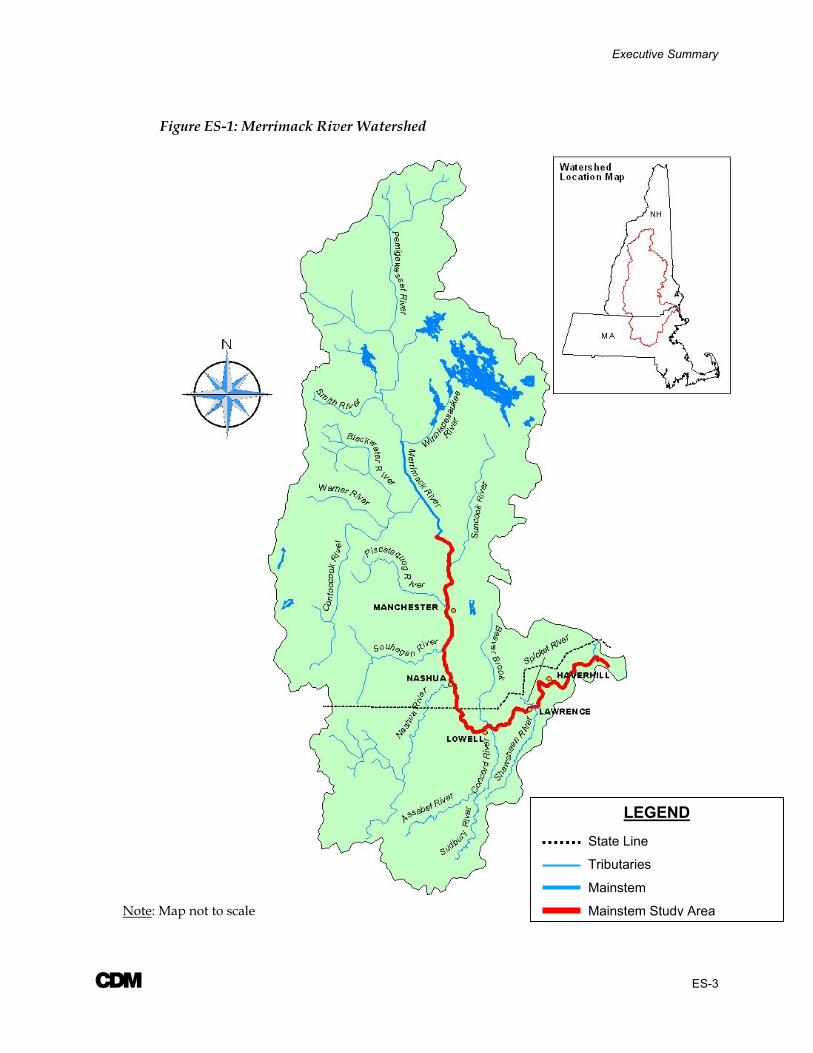
A map of the overall watershed is provided in Figure ES-1.
The land use composition of each sub-watershed was determined using a Geographic Information System (GIS). The following eight land use categories were used:
Forest/ Rural Open
Urban Open
Agricultural/ Pasture
Medium Density Residential
Commercial
Industrial
Highway
Water/ Wetlands
Executive Summary
A ES-3
Figure ES-1: Merrimack River Watershed
LEGEND
State Line
Tributaries
Mainstem
Mainstem Study AreaNote: Map not to scale

Executive Summary
A ES-4
Pollutant loading rates in the form of event mean concentrations (EMCs) were associated with each of the land use values to simulate pollutant loads carried in the stormwater runoff. The EMC values were developed from a variety of sources including (1) default values available in WMM, (2) regional values averaged from studies in the New England area, and (3) national values averaged throughout the United States. In general, the EMCs were fairly consistent across all the sources. As a result, CDM recommended the use of the regional data, where available (i.e. for commercial, industrial, and medium density residential land use), and the use of the default WMM values for all other land uses.
Information on existing point source discharges, including CSOs and municipal and industrial dischargers, was also input into WMM. CSO concentrations and annual discharge volumes were based on information contained in the Long-Term Control Plans for the five sponsor communities. Information on the point source discharge concentrations and volumes was based on data obtained from the USEPA. Data for each source was summarized in the “Summary of Information on Pollutant Sources” Report prepared under Task 2C of this Study.
WMM was used to estimate the annual pollutant loads from failing septic systems in the watershed. Since the model does not account for the portion of the loading that may be attributed to operational septic systems, this value was estimated outside of WMM using a method accepted by the Massachusetts Department of Environmental Protection.
For the purposes of WMM, the following three hydrologic conditions were evaluated: drought, normal, and wet conditions corresponding to the 5th, 50th, and 95th percentiles of annual precipitation data, based on statistical analysis of precipitation records at nine COOP stations throughout the watershed. An average of the precipitation totals corresponding to the drought, normal, and wet conditions at the nine stations was used in the WMM analysis, as noted below:
Drought: 33.68 inches
Normal: 43.84 inches
Wet: 55.68 inches
Executive Summary
A ES-5
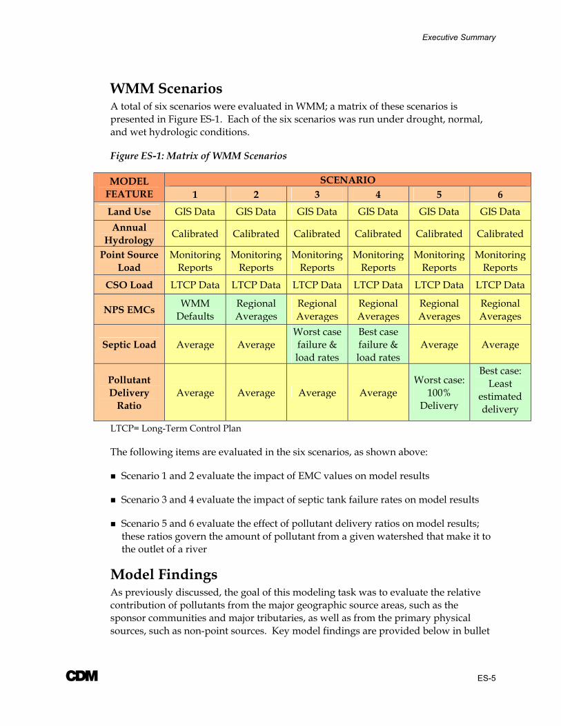
WMM Scenarios A total of six scenarios were evaluated in WMM; a matrix of these scenarios is presented in Figure ES-1. Each of the six scenarios was run under drought, normal, and wet hydrologic conditions.
Figure ES-1: Matrix of WMM Scenarios
SCENARIO MODEL FEATURE 1 2 3 4 5 6 Land Use GIS Data GIS Data GIS Data GIS Data GIS Data GIS Data Annual
Hydrology Calibrated Calibrated Calibrated Calibrated Calibrated Calibrated
Point Source Load
Monitoring Reports
Monitoring Reports
Monitoring Reports
Monitoring Reports
Monitoring Reports
Monitoring Reports
CSO Load LTCP Data LTCP Data LTCP Data LTCP Data LTCP Data LTCP Data
NPS EMCs WMM Defaults
Regional Averages
Regional Averages
Regional Averages
Regional Averages
Regional Averages
Septic Load Average Average Worst case failure & load rates
Best case failure & load rates
Average Average
Pollutant Delivery
Ratio Average Average Average Average
Worst case: 100%
Delivery
Best case: Least
estimated delivery
LTCP= Long-Term Control Plan
The following items are evaluated in the six scenarios, as shown above:
Scenario 1 and 2 evaluate the impact of EMC values on model results
Scenario 3 and 4 evaluate the impact of septic tank failure rates on model results
Scenario 5 and 6 evaluate the effect of pollutant delivery ratios on model results; these ratios govern the amount of pollutant from a given watershed that make it to the outlet of a river
Model Findings As previously discussed, the goal of this modeling task was to evaluate the relative contribution of pollutants from the major geographic source areas, such as the sponsor communities and major tributaries, as well as from the primary physical sources, such as non-point sources. Key model findings are provided below in bullet
Executive Summary
A ES-6
form, as well as a brief comparison of the model results from the six scenarios discussed in the previous section.
The WMM results suggest that non-point sources from the major tributaries dominate the annual pollutant loads for eight of the 10 parameters evaluated in this study, with the exceptions being the two nutrient parameters, total nitrogen and total phosphorus. These results were consistent across the six scenarios and three hydrologic conditions evaluated as part of this study.
The total phosphorus results suggest that annual loads are dominated by point sources in the sponsor communities (primarily the WWTPs). For total nitrogen, the results suggest that the annual loads are fairly evenly split between point source discharges in the communities and non-point source discharges in the tributaries. It is important to note, however, that no monitoring data was available for total phosphorus or total nitrogen effluent concentrations at the WWTPs.
In general, the WMM results were fairly insensitive to charges in the model assumptions, regarding EMC values, failing septic systems, and pollutant delivery ratios.
Minor changes were seen in the resulting annual loads in response to changes between the pairs of scenarios (i.e. Scenario 1 and 2, 3 and 4, and 5 and 6). These variations typically did not result in changes to the overall relative contribution of pollutant loads from the geographic and physical sources.
The model performed as expected in response to variations in the hydrologic regime between dry, normal, and wet conditions. The annual loads for each constituent increased proportionally in response to increases in the annual precipitation and changes in the pervious runoff coefficients.
Pie chart comparisons of the physical sources are provided in Figure ES-2 for the Scenario 6 results under “average” hydrologic conditions. This scenario was assumed to be the most “realistic” due to the variable pollutant delivery ratios and the average septic failure rate used.
Although the WMM results are only rough approximations of the annual loads, they do at least initially support the Merrimack River Basin Community Coalition’s hypothesis that other sources beyond CSOs may play important roles in pollutant loadings to the Merrimack River. The WMM results suggest that CSOs had little impact on the annual loads for most parameters. They were most significant in the fecal coliform and E. coli results, contributing approximately 19 and eight-percent of the annual loads, respectively.
Executive Summary
A ES-7
Limitation of WMM Results The WMM results represent pollutant loads at the annual scale. Therefore, these results are not necessarily indicative of water quality conditions and primary sources at the time-scale at which water quality exceedances occur. These results should not be used to infer information about the relative contribution of pollutants at the daily or weekly scale. For example, the WMM results suggest that non-point source pollution from the tributaries is the primary source of annual bacteria loads in the River. Although these sources may be significant at the annual level, it is possible that other factors, such as CSO discharges, could play a more important role in water quality exceedances at the daily scale, due to the distribution of loads throughout the year.
The detailed water quality and hydrologic/hydraulic models to be developed during subsequent phases of this project will be used to further refine this evaluation. These models will be able to assess water quality conditions at time steps on the order of hours and even minutes, as necessary, to identify dynamic response patterns and dominant loads over a range of events.
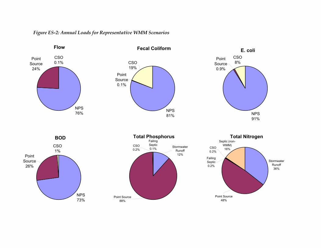
Figure ES-2: Annual Loads for Representative WMM Scenarios
Flow
NPS76%
CSO0.1%
Point Source
24%
Fecal Coliform
NPS81%
CSO19%
Point Source0.1%
E. coli
NPS91%
Point Source0.9%
CSO8%
BOD
NPS73%
Point Source
26%
CSO1%
Total Phosphorus
Point Source88%
Stormwater Runoff12%
CSO0.2%
Failing Septic0.1%
Total Nitrogen
Point Source48%
Septic (non-WMM)16%
Stormwater Runoff36%
CSO0.2%
Failing Septic0.2%

Figure ES-2 (cont'd)
Total Suspended Solids
NPS86%
CSO1%
Point Source
13%
Copper
NPS76%
CSO1%Point
Source23%
Cadmium
NPS93%
Point Source
6%
CSO1%
Lead
NPS97%
Point Source
2%
CSO1%
Zinc
NPS86%
Point Source
13%
CSO1%
A i
Contents
Executive Summary Section 1 Background
1.1 Interim Report Scope ............................................................................................... 1-1 1.2 Study Area ................................................................................................................ 1-1
Section 2 Objectives 2.1 Study Objectives....................................................................................................... 2-1 2.2 Screening Level Model Objectives......................................................................... 2-2
Section 3 Overview of the Watershed Management Model (WMM) 3.1 Model Overview....................................................................................................... 3-1 3.1.1 Water Quality Constituents ........................................................................... 3-2 3.2 Data Requirements................................................................................................... 3-3 3.3 Annual Runoff Calculations ................................................................................... 3-3 3.4 Non-Point Source Pollutant Loading Factors ...................................................... 3-4 3.5 Uncertainty Analysis ............................................................................................... 3-5 3.6 Model Limitations.................................................................................................... 3-6
Section 4 Existing Watershed Characteristics 4.1 Watershed Physical Features.................................................................................. 4-1 4.1.1 Drainage Area Delineation ......................................................................... 4-1 4.2 Land Use Summary ................................................................................................. 4-5 4.2.1 Existing Land Use in the Merrimack River Watershed .......................... 4-6 4.2.2 Comparison to Rouge River Watershed ................................................... 4-6 4.3 Event Mean Concentrations ................................................................................... 4-9 4.3.1 EMCs in the Merrimack River Watershed................................................ 4-9 4.4 Hydrologic Characteristics ................................................................................... 4-13 4.4.1 Annual Precipitation.................................................................................. 4-13 4.4.2 Annual Baseflow Characteristics ............................................................. 4-15 4.4.3 Pervious and Impervious Runoff Coefficients....................................... 4-16 4.5 Existing Combined Sewer Overflows ................................................................. 4-19 4.6 Existing Point Source Discharges ........................................................................ 4-21 4.7 On-site Wastewater Disposal Systems................................................................ 4-25 4.7.1 Summary of Watershed Area Serviced by Septic Systems .................. 4-25 4.7.2 Failing Septic Systems ............................................................................... 4-27 4.7.3 Septic Calculations Outside of WMM..................................................... 4-28
Section 5 Model Results 5.1 WMM Scenarios ....................................................................................................... 5-1 5.1.1 Scenario 1 & 2- Event Mean Concentrations ............................................ 5-2

Table of Contents
A ii
5.1.2 Scenario 3 & 4- Septic Impact ..................................................................... 5-2 5.1.3 Scenario 5 & 6- Pollutant Delivery Ratio .................................................. 5-2 5.2 Summary of Results................................................................................................. 5-3 5.2.1 Flow................................................................................................................ 5-4 5.2.2 Fecal Coliform............................................................................................... 5-4 5.2.3 E. coli.............................................................................................................. 5-6 5.2.4 Biochemcial Oxygen Demand (BOD)........................................................ 5-7 5.2.5 Total Phosphorus ......................................................................................... 5-8 5.2.6 Total Nitrogen (Nitrate/Nitrite + TKN) ................................................... 5-9 5.2.7 Total Suspended Solids (TSS)................................................................... 5-11 5.2.8 Copper ......................................................................................................... 5-12 5.2.9 Cadmium..................................................................................................... 5-13 5.2.10 Lead.............................................................................................................. 5-14 5.2.11 Zinc............................................................................................................... 5-15 5.3 Sensitivity Analysis of Percent Impervious........................................................ 5-16
Section 6 Summary of Findings 6.1 Relative Contribution of Physical and Geographic Sources .............................. 6-1 6.2 Scenario Comparison............................................................................................... 6-2 6.3 Model Limitations.................................................................................................... 6-3
Section 7 References
Appendices Appendix A EMC Memorandum Appendix B Manual Septic Calculations Appendix C WMM Results

Table of Contents
A iii
Figures
1-1 Merrimack River Watershed ................................................................................. 1-2 4-1 Merrimack River watershed sub-basin delineations and land use................... 4-4 4-2 Comparison of WMM default and regional EMC values ................................ 4-12 5-1 Matrix of WMM Scenarios ...................................................................................... 5-1 6-1 Scenario 6 Pie Chart Comparison- Average Hydrologic Comparison............. 6-4

Table of Contents
A iv
Tables
3-1 WMM Default Water Quality Parameters............................................................ 3-2 3-2 WMM Data Requirements....................................................................................... 3-3 4-1 Merrimack River Sub-watersheds ......................................................................... 4-2 4-2 Default WMM Land Use, Percent Imperviousness, and Range of
Percent DCIA used in the Rouge River Watershed Management Model ....... 4-5 4-3 Merrimack River Watershed Land Use Summary ............................................. 4-8 4-4 Summary of WMM Default and Regional Event Mean
Concentrations by Land Use Category............................................................... 4-11 4-5 Summary of Drought, Normal, and Wet Year Precipitation
Characteristics ........................................................................................................ 4-14 4-6 Summary of Mean Discharge and Baseflow Volumes at
Merrimack River in Lowell, Massachusetts....................................................... 4-16 4-7 Summary of WMM Hydrology Calibration/Validation ................................. 4-18 4-8 Summary of Average Annual CSO Discharges ................................................. 4-19 4-9 Summary of CSO Water Quality Concentrations.............................................. 4-20 4-10 Summary of Total WWTP and Industrial Discharge in the
Merrimack River Watershed................................................................................ 4-21 4-11 Summary of Point Source Water Quality ........................................................... 4-23 4-12 Summary of WWTP and Industrial Discharges ................................................ 4-24 4-13 Summary of Population, Housing and Septic System Statistics ..................... 4-26 4-14 Summary of Septic Loading Rates....................................................................... 4-27 4-15 Septic Tank Uncertainty Analysis for Medium Density Residential .............. 4-28 5-1 Pollutant Delivery Ratio Criteria ........................................................................... 5-3 5-2 Summary of Total Annual Flow Contributions under Drought,
Average, and Wet Hydrologic Conditions .......................................................... 5-4 5-3 Summary of Fecal Coliform Contributions under Average
Hydrologic Conditions ........................................................................................... 5-5 5-4 Summary of E. coli Contributions under Average Hydrologic Conditions .... 5-6 5-5 Summary of BOD Contributions under Average Hydrologic Conditions ...... 5-7 5-6 Summary of Total Phosphorus Contributions under Average
Hydrologic Conditions ........................................................................................... 5-9 5-7 Summary of Total Nitrogen Contributions under Average
Hydrologic Conditions ......................................................................................... 5-10 5-8 Summary of TSS Contributions under Average Hydrologic Conditions ...... 5-11 5-9 Summary of Copper Contributions under Average
Hydrologic Conditions ......................................................................................... 5-12 5-10 Summary of Cadmium Contributions under Average
Hydrologic Conditions ......................................................................................... 5-13
Table of Contents
A v
5-11 Summary of Lead Contributions under Average Hydrologic Conditions .... 5-14 5-12 Summary of Zinc Contributions under Average Hydrologic Conditions..... 5-15 6-1 Summary of Dominant Physical and Geographic Sources under
Average Hydrologic Conditions............................................................................ 6-2
A 1-1
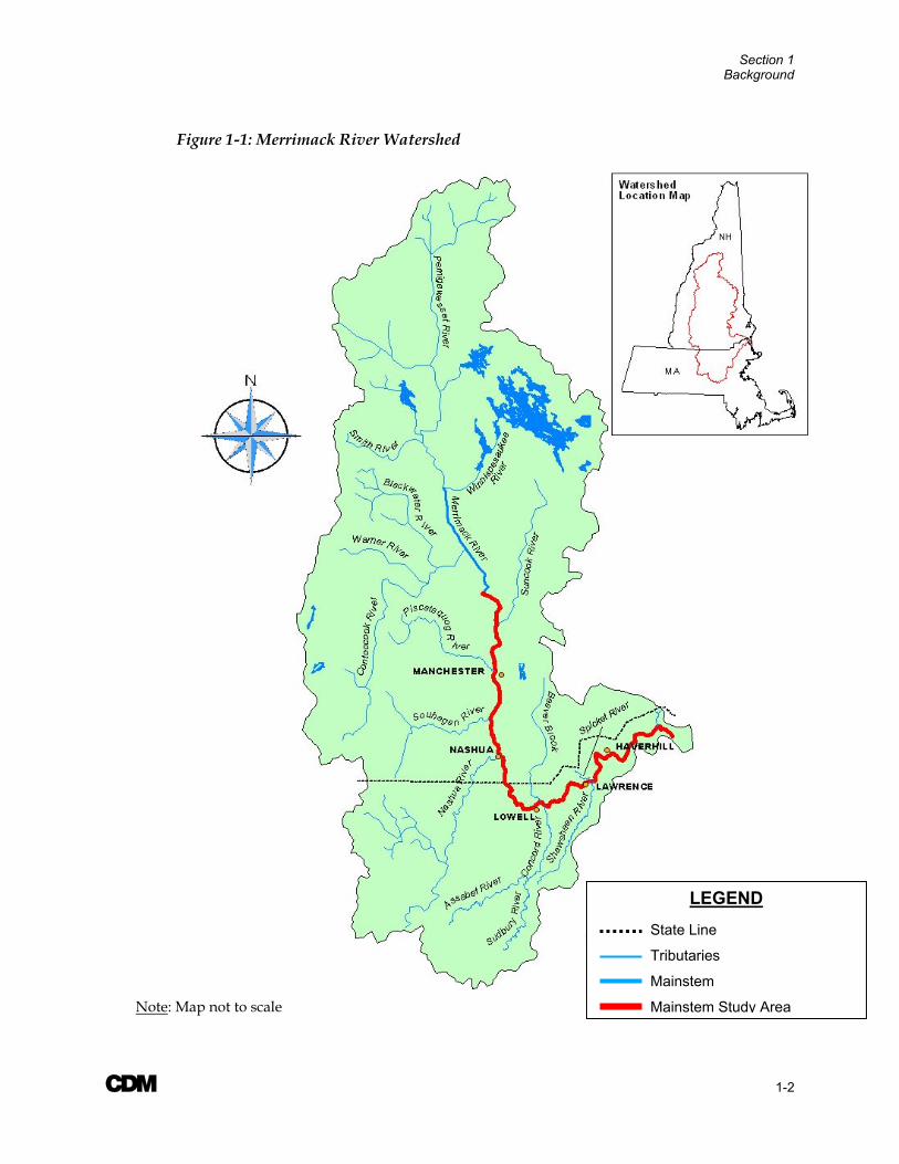
Section 1 Background 1.1 Interim Report Scope The purpose of this Interim Report is to present the results of the screening level analysis performed under Task Order 3 of the Merrimack River Watershed Assessment Study. This report describes the scope and objectives of the screening level analysis, provides a brief summary of the structure, required input data, and data sources for the Watershed Management Model (WMM) employed in this study, outlines the existing watershed characteristics central to the screening level analysis, and provides an assessment of the relative contribution of pollutant sources from throughout the watershed on an annualized level. More detailed water quality and hydrologic/hydraulic models developed in subsequent tasks of this Study will further define these pollutant sources and their relative impacts at time scales on the order of days and hours.
1.2 Study Area For the purposes of the screening level model, the entire Merrimack River watershed, including its tributaries, was included in the model to evaluate the relative impacts of all tributaries and mainstem segments. This Study Area includes the five sponsor communities of Manchester and Nashua, New Hampshire, Lowell and Haverhill, Massachusetts, and the Greater Lawrence Sanitary District (GLSD), Massachusetts. Additional information on the watershed characteristics and drainage area delineations within the Study Area is provided in Section 4.1.
For the purposes of the water quality monitoring program and future modeling efforts, the project Study Area has been defined as the portion of the Merrimack River mainstem located south of the Hooksett Falls Dam in Hooksett, New Hampshire to the mouth of the River at the Atlantic Ocean near Salisbury and Newburyport, Massachusetts. A map of the overall watershed is provided in Figure 1-1; the mainstem Study Area for the monitoring and future modeling efforts is highlighted in red.
Section 1 Background
A 1-2
Figure 1-1: Merrimack River Watershed
LEGEND
State Line
Tributaries
Mainstem
Mainstem Study AreaNote: Map not to scale
A 2-1
Section 2 Objectives This section discusses the overall study objectives, as well as the specific objectives for the screening level model analysis.
2.1 Study Objectives The overall purpose of the Merrimack River Watershed Assessment Study is to develop a comprehensive Watershed Management Plan. The Plan will be used to guide investments in the environmental resources and infrastructure of the basin and will be aimed at achieving water quality and flow conditions that support beneficial uses, including water supply, recreation, hydropower, fisheries, and other ecological habitat. The Plan will encompass the diverse interests and goals of the various partners and stakeholders throughout the Merrimack River watershed, including state, local, and Federal governments, industry, and concerned citizen groups.
The assessment will include a water resources and ecosystem restoration investigation of the Merrimack River and will be used to answer the following questions:
1. What are the impacts of pollutants on the Merrimack River mainstem with respect to state water quality standards and hence, the designated uses of water supply, recreation, and aquatic habitat?
2. What is the relative contribution of pollutants from various sources?
3. What are the existing and potential future beneficial uses of the Merrimack River?
4. What projects or “investments” will provide the most significant return on investment?
5. Which projects should have the highest priority?
The assessment study is divided into two phases, only the first of which is currently funded. The model development and analysis tasks are included in Phase I. The general purpose of each phase is discussed below:
Phase I (Funded): The primary purpose of Phase I is to identify the relative causes and impacts of pollution problems in the Merrimack River basin as they pertain to designated uses. This will be accomplished through characterization, field monitoring, simulation modeling, and planning-level review of alternative pollution abatement and management strategies. Ultimately, the output from Phase I should help decision-makers to understand the relative contributions of pollutants from various sources and the basin-wide impacts of these pollutants. The sensitivity of the mainstem water quality to incremental reductions in pollutant loads from specific sources will also be evaluated. Scenarios providing the most significant return on investments will be identified. This information may be used to guide decisions
Section 2 Objectives
A 2-2
about how best to direct funding to yield the greatest overall benefits with respect to the designated uses of the River.
Phase II (Not Yet Funded): Phase II will build on the results from Phase I, and may potentially include additional field monitoring to investigate specific areas of interest or concern identified during Phase I. Additionally, it is excepted that a detailed cost-benefit analysis will be conducted during Phase II to evaluate a wide array of possible abatement, control, and restoration initiatives, building upon those scenarios identified during Phase I. The simulation modeling and planning-level alternatives analysis performed during Phase I will serve as the basis for the development of optimization models during this second phase of the project. The optimization models may help to identify potential alternatives that are both economically and environmentally successful. Ultimately, the output from Phase II will be a prioritized list of recommended investments throughout the Merrimack River watershed aimed at improving beneficial uses and restoring ecosystems.
2.2 Screening Level Model Objectives The primary objectives of the screening level model are as follows:
Assess the relative annual mass contribution of pollutant from various sources, including stormwater runoff from land use based pollutant loadings, Combined Sewer Overflows (CSOs), industrial point sources, and wastewater treatment plants (WWTPs)
Assess the relative contribution of pollutant from geographic source areas, such as the major tributary basins, mainstem segments, and five sponsor communities
Identify key pollutants and geographic focus areas for future water quality and hydrology/hydraulic modeling efforts
Evaluate the sensitivity of model results to various WMM assumption, including event mean concentrations (EMCs), percentage of failing septic tanks, and pollutant attenuation factors
The model objectives discussed above will be used as a guide for the development of the WMM model and the choice of model scenarios. The WMM model will not be used to evaluate pollutant abatement scenarios; this work will be performed during subsequent, more detailed modeling efforts. A description of WMM is provided in Section 3.0, including a general model overview, a discussion of data requirements, and model limitations.

A 3-1
Section 3 Overview of the Watershed Management Model (WMM) The following section provides an overview of the Watershed Management Model (WMM), including the model structure, the required input data, methods for estimating annual runoff and non-point source pollutant loadings, and the model limitations.
3.1 Model Overview The Watershed Management Model (WMM) was developed as a database model to estimate relative changes in the annual or seasonal pollutant loads from various sources within a watershed as a result of changes in land use or due to the implementation of stormwater Best Management Practices (BMPs). The model was developed specifically as a planning-level tool to address the watershed management needs of non-point source pollution and to compare the relative contribution of loads by source or geographic area. WMM uses land use categories and associated event mean concentrations (EMCs), depending on the constituent of concern, to simulate pollutant loads carried in stormwater runoff. The model may also be used to estimate loads from other pollution sources, including wastewater treatment plants (WWTPs), industrial point sources, Combined Sewer Overflows (CSOs), and failing septic systems. Within a given watershed, multiple subbasins may be evaluated using WMM. Subbasins may be delineated based on hydrologic divides or jurisdictional boundaries, such as town lines. WMM is a public domain model originally developed by CDM for the Florida Department of Environmental Protection and enhanced for the USEPA as part of the Rouge River National Wet-Weather Demonstration Project.
Some key features of WMM include:
Estimates average annual runoff pollutant loads and concentrations for nutrients, oxygen demand, and sediment based upon EMCs, land use, imperviousness, annual precipitation, and annual baseflow
Estimates annual pollutant loads from stream baseflow
Estimates annual pollutant loads from CSOs
Estimates point source loads for comparison with relative magnitude of other watershed pollutant loads
Estimates pollutant loads from failing septic systems
Applies a delivery ratio to account for reduction in runoff pollutant load due to uptake or removal in stream courses
Section 3 WMM Overview
A 3-2
WMM may also be used to evaluate the effectiveness of various pollutant abatement strategies. For example, WMM may be used to evaluate alternative non-point source pollution management strategies, such as combinations of source and treatment control options, as well as various CSO controls. Both structural and non-structural controls may be evaluated. The use of this tool in the context of the Merrimack River Watershed Assessment Study will be evaluated following the development of more detailed simulation models and the identification of alternatives.
As noted above, WMM may be used to evaluate pollutant loads from baseflow components. However, it was decided that this feature would not be used in the model of the Merrimack River watershed due to concern over the potential for double counting of pollutant loads from point sources and septic systems in the baseflow. In WMM, the baseflow loads are calculated from observed dry-weather water quality data and user-defined estimates of the annual baseflow volume. Although dry-weather water quality data was available in the Merrimack River, these values do not purely represent the “baseflow” water quality, as discharges from septic systems and point source discharges are included in these values. Since there was no way to easily disaggregate the pollutant contributions in the dry-weather monitoring data from these sources, the decision was made to only use the WMM capabilities for evaluating non-point sources, point sources, and CSO discharges.
3.1.1 Water Quality Constituents WMM estimates loads from pollutants that are most frequently associated with non-point pollution sources. Table 3-1 provides a summary of the default constituents included in the model.
Table 3-1: WMM Default Water Quality Parameters
Pollutant Category Constituent Oxygen Demand Biochemcial Oxygen Demand (BOD) Carbonaceous Oxygen Demand (COD)1 Sediment Total Suspended Solids (TSS) Total Dissolved Solids (TDS)1 Nutrients Total Phosphorus Dissolved Phosphorus1 Total Kjeldahl Nitrogen Nitrate + Nitrite Metals Lead Copper Zinc Cadmium Bacteria Fecal Coliform
1Parameter not evaluated as part of the Watershed Management Model prepared for the Merrimack River watershed
Section 3 WMM Overview
A 3-3
For the Merrimack River Watershed Assessment Study, E. coli bacteria will also be evaluated as part of the screening level model. It is assumed that the dynamics of the E. coli bacteria perform similar to the fecal coliform bacteria, which is a default parameter in WMM.
COD, dissolved phosphorus, and total dissolved solids were not considered to be of interest in the Merrimack River watershed, and as such, were not included in the model developed for this study.
3.2 Data Requirements The WMM interface consists of several data input modules, which require the user to enter information on the existing watershed characteristics and the existing pollutant sources. A summary of the data required to run WMM is provided in Table 3-2. Additional information on the data used in the model for the Merrimack River watershed is provided in Section 4.0 of this report.
Table 3-2: WMM Data Requirements
Data Type Data Watershed Characteristics Watershed or sub-watershed area (in acres) Existing land use coverage for each watershed or sub-
catchment (values calculated as percent of total drainage area)
Percentage of impervious cover by land use category Hydrologic Data Long-term average annual precipitation Average annual baseflow Water Quality Data Event Mean Concentrations (EMCs) by land use for
each water quality parameter Inventory of point source discharges, include estimate
of average annual discharge volume and pollutant concentrations
Combined Sewer Overflows Estimate of CSO average annual discharge volume and pollutant concentrations Estimate of septic system service area On-site Wastewater
Disposal Systems Estimate of septic tank failure rate
3.3 Annual Runoff Calculations WMM calculates the annual runoff from pervious and impervious areas in each land use category by multiplying the average annual rainfall volume by a runoff coefficient. A runoff coefficient of between 0.85 and 1.0 is typically used for impervious areas (i.e. 85-percent to 100-percent of the rainfall is assumed to be converted to runoff from the impervious fraction of each land use). A pervious area runoff coefficient of between 0.05 and 0.30 is typically used.
Section 3 WMM Overview
A 3-4
The total average annual surface runoff from land use “L” is calculated by weighting the impervious and pervious area runoff factors for each land use category as follows:
( ) ( )[ ] IIMPCIMPCR LILpL ×+−= 1 (3-1)
where:
RL= Total average annual surface runoff from land use L (inches/year)
IMPL= Fractional imperviousness of land use L
I= Long-term average annual precipitation (inches/year)
CP= Pervious area runoff coefficient
CI= Impervious area runoff coefficient
(Source: Rouge River National Wet Weather Demonstration Project 1998)
Total runoff in a watershed is the area-weighted sum of RL for all land uses. Information on the percent of imperviousness for each watershed in the Merrimack River model is provided in Section 4.2.
3.4 Non-Point Source Pollutant Loading Factors The model estimates non-point pollutant loadings based on loading factors that vary by land use and the associated percent imperviousness. The pollutant loading factor ML is computed for each land use “L” by the following equation:
KREMCM LLL ××= (3-2)
Where:
ML= Loading factor for land use L (lbs/acre/year)
EMCL= Event Mean Concentration (EMC) of runoff from land use L (EMC varies by land use and pollutant)
RL= Total average annual surface runoff from land use L computed by Equation 3-1 (inches/year)
K= 0.2266, a unit conversion constant
(Source: Rouge River National Wet Weather Demonstration Project 1998)
The total annual pollutant load from a sub-basin may be calculated by multiplying the pollutant loading factor by the acreage in each land use and summing for all land uses. For fecal coliform, a conversion multiplier allows an annual load with units of counts per year to be calculated.
Section 3 WMM Overview
A 3-5
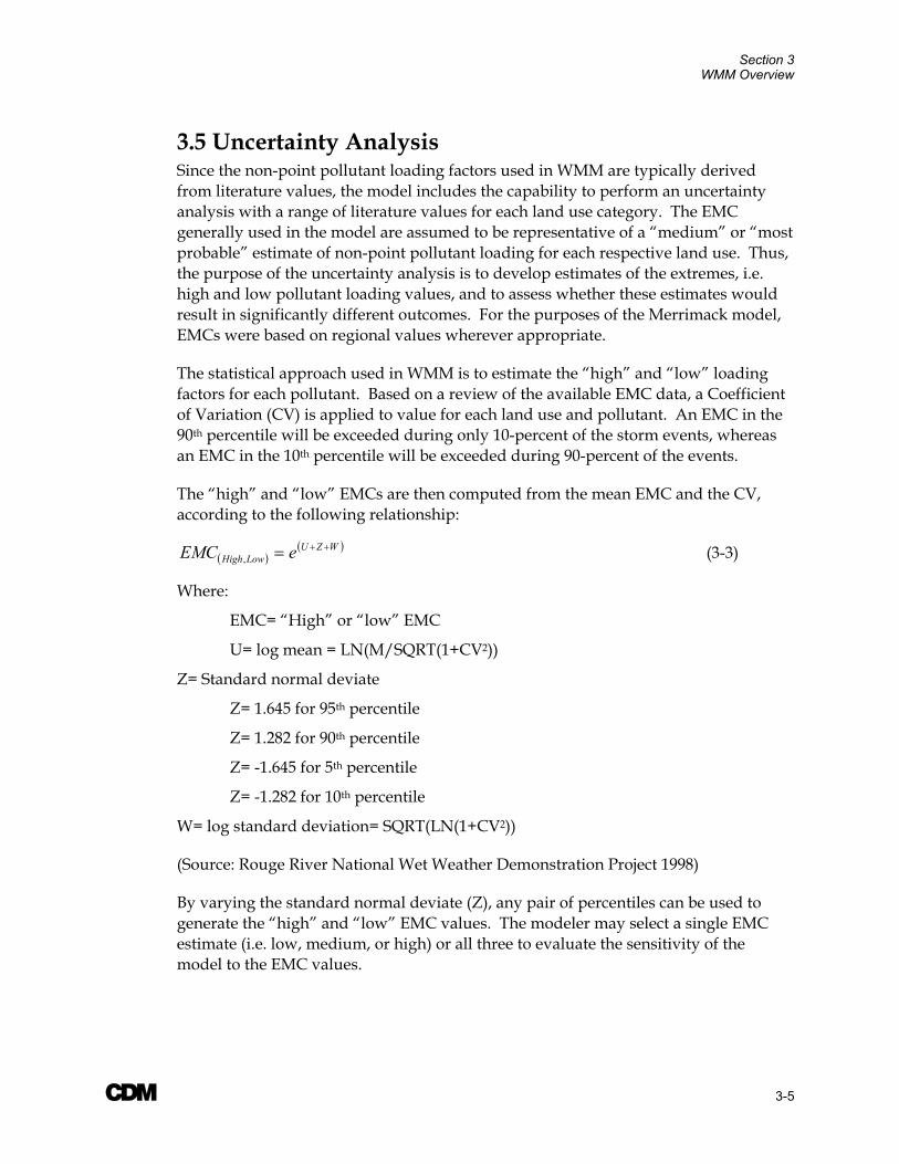
3.5 Uncertainty Analysis Since the non-point pollutant loading factors used in WMM are typically derived from literature values, the model includes the capability to perform an uncertainty analysis with a range of literature values for each land use category. The EMC generally used in the model are assumed to be representative of a “medium” or “most probable” estimate of non-point pollutant loading for each respective land use. Thus, the purpose of the uncertainty analysis is to develop estimates of the extremes, i.e. high and low pollutant loading values, and to assess whether these estimates would result in significantly different outcomes. For the purposes of the Merrimack model, EMCs were based on regional values wherever appropriate.
The statistical approach used in WMM is to estimate the “high” and “low” loading factors for each pollutant. Based on a review of the available EMC data, a Coefficient of Variation (CV) is applied to value for each land use and pollutant. An EMC in the 90th percentile will be exceeded during only 10-percent of the storm events, whereas an EMC in the 10th percentile will be exceeded during 90-percent of the events.
The “high” and “low” EMCs are then computed from the mean EMC and the CV, according to the following relationship:
( )( )WZU
LowHigh eEMC ++=, (3-3)
Where:
EMC= “High” or “low” EMC
U= log mean = LN(M/SQRT(1+CV2))
Z= Standard normal deviate
Z= 1.645 for 95th percentile
Z= 1.282 for 90th percentile
Z= -1.645 for 5th percentile
Z= -1.282 for 10th percentile
W= log standard deviation= SQRT(LN(1+CV2))
(Source: Rouge River National Wet Weather Demonstration Project 1998)
By varying the standard normal deviate (Z), any pair of percentiles can be used to generate the “high” and “low” EMC values. The modeler may select a single EMC estimate (i.e. low, medium, or high) or all three to evaluate the sensitivity of the model to the EMC values.

Section 3 WMM Overview
A 3-6
3.6 Model Limitations The Watershed Management Model predicts average annual or seasonal pollutant loadings discharged from the watershed. As previously discussed, the model may also be used to predict the cumulative effects of alternative watershed management decisions (i.e. CSO controls). The model should only be applied to the appropriate spatial (watershed-wide) and temporal (annual or seasonal) scale.

A 4-1
Section 4 Existing Watershed Characteristics The following section provides a summary of the existing watershed characteristics that were used to develop the Watershed Management Model (WMM) for the Merrimack River watershed. This includes information on the existing land uses, hydrologic characteristics, baseflow concentrations, on-site wastewater disposal systems, and existing point source discharges.
4.1 Watershed Physical Features The Merrimack River is formed by the confluence of the Pemigewasset and Winnipesaukee Rivers in Franklin, New Hampshire. The River flows southward for approximately 78 miles in New Hampshire, before it turns abruptly across the New Hampshire-Massachusetts border and flows in a northeasterly direction for approximately another 50 miles in Massachusetts before discharging to the Atlantic Ocean at Newburyport. The mainstem Merrimack River flows past the five major urban centers of Manchester and Nashua, New Hampshire and Lowell, Lawrence, and Haverhill, Massachusetts. The final 22 miles of the River are tidally influenced below Haverhill, Massachusetts.
The Merrimack River watershed covers an area of approximately 5,010 square miles in the south-central portions of New Hampshire (76-percent of the drainage area) and the northeastern portions of Massachusetts (24-percent of the drainage area) (see Figure 1-1), making it the fourth largest watershed in New England. Geographically, the basin encompasses a variety of terrain, from the relatively steep conditions of the White Mountain region in northern New Hampshire to the estuarine coastal basin of northeastern Massachusetts.
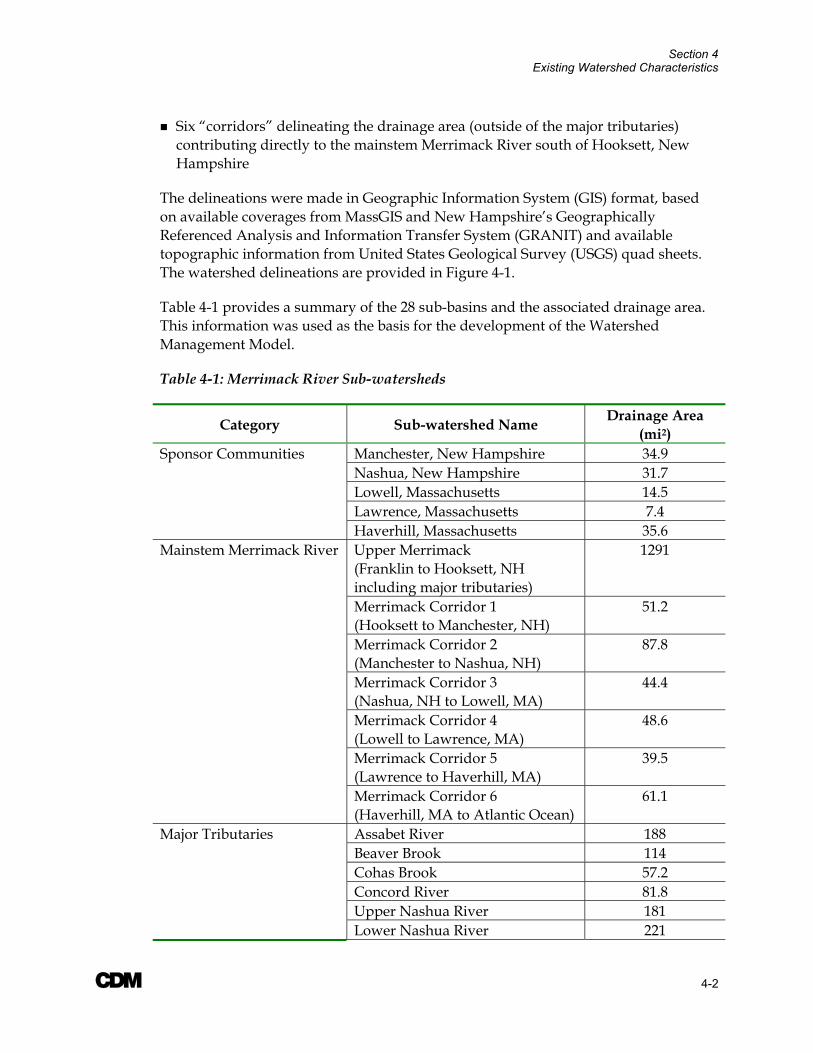
4.1.1 Drainage Area Delineation For the purposes of the screening level analysis, the Merrimack River watershed was divided into 28 sub-catchments, in accordance with the following boundaries:
Watershed delineations for the Pemigewasset and Winnipesaukee Rivers, which join to form the Merrimack River in Franklin, New Hampshire
The contributing drainage area to the mainstem Merrimack River from its start in Franklin, New Hampshire to north of Hooksett, New Hampshire (including major tributaries, such as the Contoocook, Soucook, and Suncook Rivers which join the Merrimack River in this region)
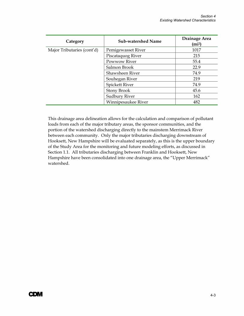
The contributing drainage area to 11 major tributaries (see Table 1-1) that join the Merrimack River downstream of Hooksett, New Hampshire
Separate delineations for each of the five sponsor communities of Manchester and Nashua, New Hampshire and Lowell, Lawrence, and Haverhill, Massachusetts in order to determine the relative contribution of pollutants from each community
Section 4 Existing Watershed Characteristics
A 4-2
Six “corridors” delineating the drainage area (outside of the major tributaries) contributing directly to the mainstem Merrimack River south of Hooksett, New Hampshire
The delineations were made in Geographic Information System (GIS) format, based on available coverages from MassGIS and New Hampshire’s Geographically Referenced Analysis and Information Transfer System (GRANIT) and available topographic information from United States Geological Survey (USGS) quad sheets. The watershed delineations are provided in Figure 4-1.
Table 4-1 provides a summary of the 28 sub-basins and the associated drainage area. This information was used as the basis for the development of the Watershed Management Model.
Table 4-1: Merrimack River Sub-watersheds
Category Sub-watershed Name Drainage Area (mi2)
Sponsor Communities Manchester, New Hampshire 34.9 Nashua, New Hampshire 31.7 Lowell, Massachusetts 14.5 Lawrence, Massachusetts 7.4 Haverhill, Massachusetts 35.6 Mainstem Merrimack River Upper Merrimack
(Franklin to Hooksett, NH including major tributaries)
1291
Merrimack Corridor 1 (Hooksett to Manchester, NH)
51.2
Merrimack Corridor 2 (Manchester to Nashua, NH)
87.8
Merrimack Corridor 3 (Nashua, NH to Lowell, MA)
44.4
Merrimack Corridor 4 (Lowell to Lawrence, MA)
48.6
Merrimack Corridor 5 (Lawrence to Haverhill, MA)
39.5
Merrimack Corridor 6 (Haverhill, MA to Atlantic Ocean)
61.1
Major Tributaries Assabet River 188 Beaver Brook 114 Cohas Brook 57.2 Concord River 81.8 Upper Nashua River 181 Lower Nashua River 221
Section 4 Existing Watershed Characteristics
A 4-3
Category Sub-watershed Name Drainage Area (mi2)
Major Tributaries (cont’d) Pemigewasset River 1017 Piscataquog River 215 Powwow River 55.4 Salmon Brook 22.9 Shawsheen River 74.9 Souhegan River 219 Spickett River 74.9 Stony Brook 45.6 Sudbury River 162 Winnipesaukee River 482
This drainage area delineation allows for the calculation and comparison of pollutant loads from each of the major tributary areas, the sponsor communities, and the portion of the watershed discharging directly to the mainstem Merrimack River between each community. Only the major tributaries discharging downstream of Hooksett, New Hampshire will be evaluated separately, as this is the upper boundary of the Study Area for the monitoring and future modeling efforts, as discussed in Section 1.1. All tributaries discharging between Franklin and Hooksett, New Hampshire have been consolidated into one drainage area, the “Upper Merrimack” watershed.
���������������
����� �������������������������������������������������������������������������������
�����
!������"�#������������!������"�#������
!�$����%���
&�����
��'(���
!�&��(�#(�
� (
� �(&�(
�������
�����
�����&����
���������%��
������&����
������)����%��
�����
*��%���*���"
����������������
���"�����%��
������*���"
!������"���������+��������%��
!������"���������,
!������"���������-
!������"���������.
�������*���"
!������"���������/
!������"���������0
!������"
�����������
�������"�
��������������� �����������������
������ ����������������������������������������������������
-1 1 -1 +1 !���

Section 4 Existing Watershed Characteristics
A 4-5
4.2 Land Use Summary The quality and quantity of stormwater runoff in WMM is directly related to the land use and its associated imperviousness. Table 4-2 provides a summary of the 10 default land use categories specified in the model; users may add additional land use categories to the model, as necessary.
Also included in the table is a summary of the default percent imperviousness assigned to each land used category in WMM, as well as the range of percent directly connected impervious area (DCIA) used in the development of the Watershed Management Model prepared for the Rouge River. The percent DCIA is defined as the portion of the total impervious area which discharges directly to the hydraulic system. Using a single-family home as an example, precipitation falls on the impervious rooftops, sidewalks, and driveways. The sum of these impervious surfaces may represent 30-percent or more of the total lot. However, much of the rain that falls on the roof may drain to the grass, where it can infiltrate. Therefore, not all of the 30-percent impervious area actually contributes runoff to the stormdrain system. According to the WMM User’s Manual (1998), the DCIA percentage is typically on the order of one-half of the total impervious area percentage. For the purposes of the Rouge model, the percent DCIAs listed in Table 4-2 were used to calculate the WMM runoff volumes. These percentages were calculated for the Rouge sub-watersheds based on field evaluations in sample areas. As can be seen in Table 4-2, the default percent impervious values provided in WMM fall within the range of percent DCIA calculated for the Rouge River watershed, indicating that these values have been corrected to account for the estimated percent of impervious area directly connected to the hydraulic system.
Table 4-2: Default WMM Land Use, Percent Imperviousness, and Range of Percent DCIA used in the Rouge Watershed Management Model
Land Use Category WMM Default Percent Imperviousness
Range of % DCIA for the Rouge River watershed
Forest/Rural Open 0.5% 0%- 15.1% Urban Open 0.5% 0%- 15.4%
Agricultural/Pasture 0.5% 0%- 4.6% Low Density Residential1 3.0% 0%- 11.8%
Medium Density Residential 16.6% 5.0%- 26.5% High Density Residential1 19.6% 0%- 54.8%
Commercial 37.1% 11.3%- 58.9% Industrial 67.7% 2.2%- 90.3% Highway 5.0% 0%- 60.9%
Water/Wetlands 56.7% 28.0%- 100% 1Land use not used in the WMM for the Merrimack River watershed
Section 4 Existing Watershed Characteristics
A 4-6
The default percentages listed in Table 4-2 were used in the development of the Watershed Management Model for the Merrimack River, since existing information on the impervious cover was not available basin-wide for the Merrimack River watershed. However, the estimated percentage of impervious area was verified during the hydrologic calibration, discussed further in Section 4.4.
It should be noted that the estimated percent imperviousness used in WMM for the highway land use category falls on the low end of the range of typically expected percent DCIA. A sensitivity analysis was performed using the calibrated WMM for the Merrimack River watershed to assess the impact of this estimated percentage on the overall model results. A discussion of this analysis is provided in Section 5.3.
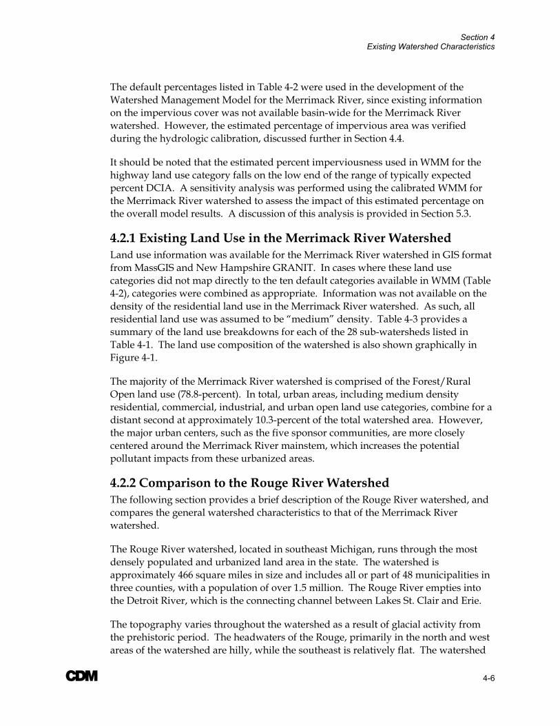
4.2.1 Existing Land Use in the Merrimack River Watershed Land use information was available for the Merrimack River watershed in GIS format from MassGIS and New Hampshire GRANIT. In cases where these land use categories did not map directly to the ten default categories available in WMM (Table 4-2), categories were combined as appropriate. Information was not available on the density of the residential land use in the Merrimack River watershed. As such, all residential land use was assumed to be “medium” density. Table 4-3 provides a summary of the land use breakdowns for each of the 28 sub-watersheds listed in Table 4-1. The land use composition of the watershed is also shown graphically in Figure 4-1.
The majority of the Merrimack River watershed is comprised of the Forest/Rural Open land use (78.8-percent). In total, urban areas, including medium density residential, commercial, industrial, and urban open land use categories, combine for a distant second at approximately 10.3-percent of the total watershed area. However, the major urban centers, such as the five sponsor communities, are more closely centered around the Merrimack River mainstem, which increases the potential pollutant impacts from these urbanized areas.
4.2.2 Comparison to the Rouge River Watershed The following section provides a brief description of the Rouge River watershed, and compares the general watershed characteristics to that of the Merrimack River watershed.
The Rouge River watershed, located in southeast Michigan, runs through the most densely populated and urbanized land area in the state. The watershed is approximately 466 square miles in size and includes all or part of 48 municipalities in three counties, with a population of over 1.5 million. The Rouge River empties into the Detroit River, which is the connecting channel between Lakes St. Clair and Erie.
The topography varies throughout the watershed as a result of glacial activity from the prehistoric period. The headwaters of the Rouge, primarily in the north and west areas of the watershed are hilly, while the southeast is relatively flat. The watershed

Section 4 Existing Watershed Characteristics
A 4-7
contains a range of land uses, from rural, undeveloped areas in the west and north, to urban, highly developed areas in the east and south. Nearly 67-percent of the Rouge River watershed is comprised of urban land uses. The majority of the urban development (47-percent) consists of single and multi-family residential developments. Approximately 20-percent of the watershed is in the commercial, industrial, and transportation land use category. Approximately 24-percent of the Rouge River watershed is open/undeveloped, and another ten-percent is agricultural.
Eleven of the 48 communities in the Rouge River watershed are entirely or partially served by combined sewer systems. The combined sewer service area of these communities is approximately 58,000 acres (nearly 90 square miles), which is close to 20-percent of the total drainage area. There are approximately 115 CSO outfalls in the Rouge River watershed.
By comparison, the Merrimack River watershed as a whole has a significantly lower percentage of urbanized area. However, the land use composition of the five sponsor communities is fairly similar to that of the Rouge River watershed.
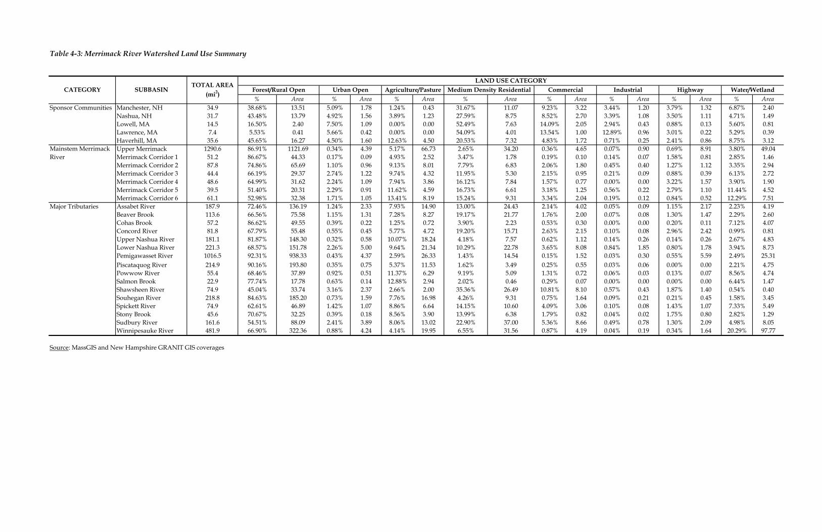
Table 4-3: Merrimack River Watershed Land Use Summary
% Area % Area % Area % Area % Area % Area % Area % AreaSponsor Communities Manchester, NH 34.9 38.68% 13.51 5.09% 1.78 1.24% 0.43 31.67% 11.07 9.23% 3.22 3.44% 1.20 3.79% 1.32 6.87% 2.40
Nashua, NH 31.7 43.48% 13.79 4.92% 1.56 3.89% 1.23 27.59% 8.75 8.52% 2.70 3.39% 1.08 3.50% 1.11 4.71% 1.49Lowell, MA 14.5 16.50% 2.40 7.50% 1.09 0.00% 0.00 52.49% 7.63 14.09% 2.05 2.94% 0.43 0.88% 0.13 5.60% 0.81Lawrence, MA 7.4 5.53% 0.41 5.66% 0.42 0.00% 0.00 54.09% 4.01 13.54% 1.00 12.89% 0.96 3.01% 0.22 5.29% 0.39Haverhill, MA 35.6 45.65% 16.27 4.50% 1.60 12.63% 4.50 20.53% 7.32 4.83% 1.72 0.71% 0.25 2.41% 0.86 8.75% 3.12Upper Merrimack 1290.6 86.91% 1121.69 0.34% 4.39 5.17% 66.73 2.65% 34.20 0.36% 4.65 0.07% 0.90 0.69% 8.91 3.80% 49.04Merrimack Corridor 1 51.2 86.67% 44.33 0.17% 0.09 4.93% 2.52 3.47% 1.78 0.19% 0.10 0.14% 0.07 1.58% 0.81 2.85% 1.46Merrimack Corridor 2 87.8 74.86% 65.69 1.10% 0.96 9.13% 8.01 7.79% 6.83 2.06% 1.80 0.45% 0.40 1.27% 1.12 3.35% 2.94Merrimack Corridor 3 44.4 66.19% 29.37 2.74% 1.22 9.74% 4.32 11.95% 5.30 2.15% 0.95 0.21% 0.09 0.88% 0.39 6.13% 2.72Merrimack Corridor 4 48.6 64.99% 31.62 2.24% 1.09 7.94% 3.86 16.12% 7.84 1.57% 0.77 0.00% 0.00 3.22% 1.57 3.90% 1.90Merrimack Corridor 5 39.5 51.40% 20.31 2.29% 0.91 11.62% 4.59 16.73% 6.61 3.18% 1.25 0.56% 0.22 2.79% 1.10 11.44% 4.52Merrimack Corridor 6 61.1 52.98% 32.38 1.71% 1.05 13.41% 8.19 15.24% 9.31 3.34% 2.04 0.19% 0.12 0.84% 0.52 12.29% 7.51
Major Tributaries Assabet River 187.9 72.46% 136.19 1.24% 2.33 7.93% 14.90 13.00% 24.43 2.14% 4.02 0.05% 0.09 1.15% 2.17 2.23% 4.19Beaver Brook 113.6 66.56% 75.58 1.15% 1.31 7.28% 8.27 19.17% 21.77 1.76% 2.00 0.07% 0.08 1.30% 1.47 2.29% 2.60Cohas Brook 57.2 86.62% 49.55 0.39% 0.22 1.25% 0.72 3.90% 2.23 0.53% 0.30 0.00% 0.00 0.20% 0.11 7.12% 4.07Concord River 81.8 67.79% 55.48 0.55% 0.45 5.77% 4.72 19.20% 15.71 2.63% 2.15 0.10% 0.08 2.96% 2.42 0.99% 0.81Upper Nashua River 181.1 81.87% 148.30 0.32% 0.58 10.07% 18.24 4.18% 7.57 0.62% 1.12 0.14% 0.26 0.14% 0.26 2.67% 4.83Lower Nashua River 221.3 68.57% 151.78 2.26% 5.00 9.64% 21.34 10.29% 22.78 3.65% 8.08 0.84% 1.85 0.80% 1.78 3.94% 8.73Pemigawasset River 1016.5 92.31% 938.33 0.43% 4.37 2.59% 26.33 1.43% 14.54 0.15% 1.52 0.03% 0.30 0.55% 5.59 2.49% 25.31Piscataquog River 214.9 90.16% 193.80 0.35% 0.75 5.37% 11.53 1.62% 3.49 0.25% 0.55 0.03% 0.06 0.00% 0.00 2.21% 4.75Powwow River 55.4 68.46% 37.89 0.92% 0.51 11.37% 6.29 9.19% 5.09 1.31% 0.72 0.06% 0.03 0.13% 0.07 8.56% 4.74Salmon Brook 22.9 77.74% 17.78 0.63% 0.14 12.88% 2.94 2.02% 0.46 0.29% 0.07 0.00% 0.00 0.00% 0.00 6.44% 1.47Shawsheen River 74.9 45.04% 33.74 3.16% 2.37 2.66% 2.00 35.36% 26.49 10.81% 8.10 0.57% 0.43 1.87% 1.40 0.54% 0.40Souhegan River 218.8 84.63% 185.20 0.73% 1.59 7.76% 16.98 4.26% 9.31 0.75% 1.64 0.09% 0.21 0.21% 0.45 1.58% 3.45Spickett River 74.9 62.61% 46.89 1.42% 1.07 8.86% 6.64 14.15% 10.60 4.09% 3.06 0.10% 0.08 1.43% 1.07 7.33% 5.49Stony Brook 45.6 70.67% 32.25 0.39% 0.18 8.56% 3.90 13.99% 6.38 1.79% 0.82 0.04% 0.02 1.75% 0.80 2.82% 1.29Sudbury River 161.6 54.51% 88.09 2.41% 3.89 8.06% 13.02 22.90% 37.00 5.36% 8.66 0.49% 0.78 1.30% 2.09 4.98% 8.05Winnipesauke River 481.9 66.90% 322.36 0.88% 4.24 4.14% 19.95 6.55% 31.56 0.87% 4.19 0.04% 0.19 0.34% 1.64 20.29% 97.77
Source: MassGIS and New Hampshire GRANIT GIS coverages
CATEGORY
Mainstem Merrimack River
Forest/Rural Open Urban Open Highway Water/WetlandSUBBASINTOTAL AREA
(mi2)
LAND USE CATEGORYAgriculture/Pasture Medium Density Residential Commercial Industrial

Section 4 Existing Watershed Characteristics
A 4-9
4.3 Event Mean Concentrations Non-point source loads calculated by WMM are a combination of pollutant loads resulting from stormwater runoff and from “failing” septic systems (total phosphorus and nitrogen). WMM uses land use categories and associated event mean concentrations (EMCs), depending on the constituent of concern, to simulate pollutant loads carried in stormwater runoff. Thus, EMCs are a key component of the non-point source pollution estimates in WMM. The following section provides a summary of the regional EMCs developed for the Merrimack River watershed, as well as the default WMM EMC values.
4.3.1 EMCs in the Merrimack River Watershed Pollutant EMCs are widely available in published literature at both the national and regional scale for most of the primary pollutants of concern. EMCs are flow-weighted average concentrations calculated for a given storm event. They are defined as the sum of individual measurements of stormwater pollutant loads divided by the total storm runoff volume.
On May 15, 2003, CDM issued a memorandum summarizing the available EMC values both nationally and regionally from the following sources:
Default EMC values available in the Watershed Management Model (WMM). These values were based on data from the USEPA’s National Urban Runoff Program (NURP) (1983), the Northern Virginia Planning District Commission (1979, 1983), and the Federal Highway Administration (1990)
Regional values averaged from New England studies. Mean regional EMCs were computed from available data collected in the Boston area during the USEPA’s NURP and stormwater sampling data from other sampling programs in Boston, Massachusetts (1999-2000), Worcester, Massachusetts (2002-2003), Manchester, New Hampshire (1992), and Lowell, Massachusetts (1992)
National values averaged throughout the United States. Mean national EMCs were computed from several sources, including USEPA’s NURP, the Rouge River National Wet Weather Demonstration Project, USGS, USEPA’s National Pollutant Discharge Elimination System (NPDES) database, and monitoring data from Maryland, Michigan, and Virginia
A copy of this memorandum is included in Appendix A. Following the release of this memo, the regional values were updated based on EMC values provided in additional studies received from the USEPA that were conducted in urbanized New England areas.
A review of the available data revealed that the relative magnitude of the reported EMCs was fairly consistent among the data sources. As a result, CDM recommended the use of the New England regional EMC values for the land use categories and

Section 4 Existing Watershed Characteristics
A 4-10
pollutant constituents for which this data was available (i.e. commercial, industrial, and medium density residential), and the use of default values in the WMM model for all others. A sensitivity analysis was performed during the model runs to evaluate the sensitivity of the WMM results to changes in the EMCs between the default WMM values and the regional values (where available). Additional information on the model scenarios is provided in Section 5.
A summary of the regional and default WMM EMC values for the pollutants of concern are provided in Table 4-4 for the eight land use categories listed in Table 4-3. The coefficient of variation (CV) for each EMC is also provided, defined as the standard deviation of the available EMC values divided by their mean for each pollutant and respective land use category. The coefficient of variation is a relative measure of the variability in a data set; the higher the value, the larger the variability. In WMM, it is used to assess the uncertainty of the pollutant loading factors, as discussed in Section 3.5 of this report. Figure 4-2 provides a graphical comparison of the default WMM and regional EMCs for the commercial, industrial, and medium density residential land uses.
E. coli values were only available for the regional medium density residential land use category. Therefore, a standard conversion factor of 125 E. coli= 200 Fecal coliform bacteria was used to convert the available Fecal coliform data into E. coli values for all other land uses. Is important to note, however, that this ratio did not hold true for the medium density residential land uses, where regional data was available. In contrast, the regional data points to higher E. coli values as compared to the fecal coliform concentrations.
Table 4-4: Summary of WMM Default and Regional Event Mean Concentrations by Land Use Category
EMC CV EMC CV EMC CV EMC CV EMC CV EMC CV EMC CV EMC CV EMC CV EMC CV EMC CVBOD mg/L 3.0 0.5 21 0.3 10 0.15 3.0 0.5 24 0.3 24 0.3 12 0 38 0.4 23 1.13 3.0 0.5 4.0 0.3Total Suspended Solids mg/L 145 0.5 77 0.9 44 0.16 51 0.5 141 0.9 149 0.9 42 0.19 70 1 49 0.94 51 0.5 6.0 0.9Total Phosphorus mg/L 0.37 0.7 0.33 0.7 0.15 0.31 0.11 0.7 0.43 0.7 0.32 0.7 0.11 0.03 0.52 0.7 0.41 0.5 0.11 0.7 0.08 0.7TKN mg/L 1.92 0.5 1.74 0.4 1.25 0.4 0.94 0.5 1.82 0.4 2.08 0.4 2.9 0 3.32 0.7 2.38 0.45 0.94 0.5 0.79 0.4Nitrate/Nitrite mg/L 4.06 0.5 1.23 0.5 0.6 0.47 0.8 0.5 0.83 0.5 1.89 0.5 1.11 0.38 1.83 0.8 1.12 0.65 0.8 0.5 0.59 0.5Lead mg/L 0 0 0.049 0.7 0.101 0.54 0 0 0.049 0.7 0.072 0.7 0.063 0 0.057 0.8 0.057 1.42 0.014 0 0.011 0.7Copper mg/L 0 0 0.037 0.8 0.084 0.46 0 0 0.037 0.8 0.058 0.8 0.113 0 0.026 1 0.033 0.84 0 0 0.007 0.8Zinc mg/L 0 0 0.156 1.1 0.151 0.24 0 0 0.156 1.1 0.671 1.1 0.164 0 0.161 0.8 0.134 0.45 0.04 0 0.03 1.1Cadmium mg/L 0 0 0.003 1.1 0.002 1.08 0 0 0.003 1.1 0.005 1.1 0.0051 1.1 0.004 0.8 0.0041 0.8 0.001 0 0.001 1.1Fecal Coliform #/100mL 5,000 1 2,600 1 9,306 1 300 1 600 1 600 1 1,467 1 25,001 1 12,360 1 5,000 1 300 1E. coli2 #/100mL 3,125 1 N/A N/A 5,816 1 188 1 375 1 N/A N/A 917 1 N/A N/A 26,982 2 3,125 1 188 1
Note: Regional EMCs were not available for the following land use categories: agricultural/pasture, forest/rural open, highway, urban open, and water/wetlands1Indicates default WMM EMC and CV was used in place of regional value2All E. coli values except for the medium density residential (where regional data was used), are based on a conversion factor of 125 E. coli= 200 Fecal coliform
CV= Coefficient of Variation
WMM Default Regional EMC WMM Default Regional EMCParameter
Agriculture/ Pasture Forest/Rural OpenWMM Default Regional EMCWMM Default WMM Default
Commercial Urban Open Water/ WetlandsEMCs BY LAND USE CATEGORY
UnitsHighway
WMM Default WMM Default WMM DefaultIndustrial Medium Density Residential

Figure 4-2: Comparison of WMM Default and Regional EMC values
Commercial
0.001
0.01
0.1
1
10
100
1000
10000
BOD TSS TP TKN NO23 Pb Cu Zn Cd FC EC
mg/
L ex
pect
FC
& E
C (#
/100
mL) WMM Default
Regional EMCs
Industrial
0.001
0.01
0.1
1
10
100
1000
10000
BOD TSS TP TKN NO23 Pb Cu Zn Cd FC EC
mg/
L ex
pect
FC
& E
C (#
/100
mL) WMM Default
Regional EMCs
Medium Density Residential
0.001
0.01
0.1
1
10
100
1000
10000
100000
BOD TSS TP TKN NO23 Pb Cu Zn Cd FC EC
mg/
L ex
pect
FC
& E
C (#
/100
mL) WMM Default
Regional EMCs
Note: All plots are in log scale

Section 4 Existing Watershed Characteristics
A 4-13
4.4 Hydrologic Characteristics The following section provides a summary of the existing hydrologic characteristics of the Merrimack River watershed, including annual precipitation, annual baseflow volume and water quality, and pervious and impervious runoff coefficients.
4.4.1 Annual Precipitation Precipitation in the Merrimack River watershed is fairly evenly distributed throughout the year. There are, however, large spatial variations in the amount and type of precipitation (e.g. rain versus snow), primarily as a result of the effects of terrain, elevation, latitude, and proximity to the ocean (Flanagan et al. 1999).
There are currently several climate stations in the basin that operate under the National Weather Service’s Cooperative Station Network (COOP). Meteorological data collected at the COOP stations is generally limited to daily measurements of maximum and minimum temperatures, precipitation, snowfall and depth of snow on the ground. One observation is typically made at the same time each day; however, several stations in the Merrimack River watershed also record hourly precipitation. The National Weather Service also runs one “first-order” station in the watershed at the municipal airport in Concord, New Hampshire. This station records a variety of climatic parameters, including precipitation, every hour throughout the day. Additional information on these monitoring stations and precipitation characteristics in the basin is provided in Section 3.0 of “Hydraulics and Hydrology Assessment “ Report prepared under Task 3B of this Study.
For the purposes of the Watershed Management Model, the following three precipitation scenarios were analyzed (1) drought conditions, (2) normal or average conditions, and (3) wet conditions. A statistical analysis of precipitation records was performed at nine COOP stations in the watershed with long-term rainfall records (defined as 30 years or more of data). At each station the precipitation amount corresponding to the 5th, 50th, and 95th percentiles was identified. The precipitation values from the nine stations were averaged to come up with a single value that represented the drought, normal, and wet year precipitation amounts. Table 4-5 provides a summary of the climate stations used in this analysis, the station period of record, and the corresponding rainfall amount for each condition.

Table 4-5: Summary of Drought, Normal, and Wet Year Precipitation Characteristics
Drought Normal Wet NH Concord Municipal Airport 271683 1921-2001 27.85 36.45 47.99
MacDowell Dam, Peterborough 275013 1951-1991 36.92 48.47 56.31Nashua 275712 1949-1996 33.98 43.28 52.12Plymouth 276945 1952-2001 33.04 42.45 55.07
MA Ashburnham 190190 1949-2001 36.02 48.17 58.66Bedford 190535 1958-2001 36.04 45.83 58.12Haverhill 193505 1950-2001 32.51 44.22 59.63Lawrence 194105 1926-2001 32.54 42.06 53.32Newburyport 195285 1949-2001 34.23 43.62 59.90
AVERAGE= 33.68 43.84 55.68
Note: Drought= 5th percentile Normal= 50th percentile Wet= 95th percentile
StatePrecipitation (inches)
Period of RecordCOOP IDClimate Station
Section 4 Existing Watershed Characteristics
A 4-15
4.4.2 Annual Baseflow Characteristics The Merrimack River and its major tributaries evaluated in this study exhibit dry-weather flow due to baseflow, permitted industrial and municipal discharges, and illegal discharges. As discussed in Section 3.1, the baseflow pollutant load capabilities in WMM were not used for the model of the Merrimack River watershed due to concerns over the potential for double counting pollutant loads from point sources and septic systems. However, the hydrologic component of the baseflow was used to help calibrate the model.
Annual Baseflow Volume The baseflow volume contribution was estimated from daily streamflow records recorded at the USGS gaging station in the Merrimack River below the confluence of the Concord River in Lowell, Massachusetts (01100000) using a streamflow partitioning method developed by the USGS (Rutledge 1993). The USGS developed a series of FORTRAN computer programs, know as “PART”, that estimate the recession of groundwater discharge and estimate the mean groundwater recharge and discharge. The USGS analysis is based on the following two assumptions:
All groundwater discharges to the stream (except losses due to riparian evapotranspiration)
Regulation and diversion of flow is negligible
These assumptions are generally valid for the Merrimack River. However, it is important to note that there are numerous lakes and aquifers in the watershed that may intercept and store groundwater throughout the watershed; most notably is Lake Winnipesaukee, which covers an area of approximately 72 square miles. However, as discussed in the “Hydrology and Hydraulics Assessment” report prepared under Task 3B of this Study, the impoundments along the mainstem Merrimack River are typically operated under “run-of-the-river” conditions, which validates the second assumption on the mainstem.
PART estimates that baseflow is equal to streamflow on days that fit required antecedent recession conditions. The program linearly interpolates the baseflow on other days (Rutledge 1993). Daily baseflow volumes are summed for a particular year or period of record in order to obtain an average annual or period of record baseflow (Harold 1994).
Separate baseflow estimates were developed for daily streamflow data in recorded in the mainstem Merrimack River at a USGS gage in Lowell, Massachusetts (01100000) using PART for the “drought”, “normal”, and “wet” year precipitation conditions discussed in Section 4.4.1. The years for the baseflow analysis were selected based on precipitation records at the NWS station in Lawrence, Massachusetts, which is the closest COOP station to the USGS gaging station in Lowell, Massachusetts. Using the drought, normal, and wet year precipitation statistics provided in Table 4-5, data from

Section 4 Existing Watershed Characteristics
A 4-16
the Lawrence station was evaluated to identify the years that most closely approximated the three statistical values. The streamflow data from those years was then used to estimate the baseflow volume.
Table 4-6 provides a summary of the baseflow volume for each condition, as well as the period of streamflow record on which this value was based.
Table 4-6: Summary of Mean Discharge and Baseflow Volumes at Merrimack River in Lowell, Massachusetts
Mean Discharge Mean Baseflow Hydrologic Condition Year
cfs in/yr cfs in/yr Baseflow
Index2 Drought 1980 5445 16.72 3763 11.55 69.1% Normal 1960 9010 27.22 6260 19.22 69.5% Wet 1954 10,706 32.87 7400 22.72 69.1% 1Baseflow analysis performed on data collected at the USGS gaging station in the Merrimack River downstream of the confluence with the Concord River in Lowell, Massachusetts (01100000; drainage area= 4425mi2). Values are based on the calendar year, not water year
2Defined as mean baseflow/ mean discharge It is important to note these baseflow volumes do not reflect a purely groundwater component. They also include discharges from WWTP and industrial dischargers (see Section 4.6) and any water released from storage in upstream lakes and ponds. In other words, all flows not directly attributable to storm runoff are termed “baseflow”.
4.4.3 Pervious and Impervious Runoff Coefficients As part of the hydrologic parameters in WMM, the user is asked to specify pervious and impervious runoff coefficients. These parameters may be used to calibrate the model to the average annual or seasonal runoff during the calibration period. These coefficients may be used to account for surface runoff, initial abstraction, and evapotranspiration (Rouge River National Wet Weather Demonstration Project 1998). Typical ranges of the runoff coefficients are as follows:
Pervious: 0.05 to 0.30 (FDOT 1987)
Impervious: 0.85 to 1.0 (Linsley and Franziani 1979)
A different set of calibration values was developed for the each of the three hydrologic conditions evaluated in this study (i.e. drought, normal, and wet year precipitation), since soil moisture content can either increase or decrease runoff potential during different climatic conditions. The model was calibrated to the average annual streamflow at the following two USGS gaging stations:
Merrimack River near Goffs Falls, below Manchester, New Hampshire (01092000)
Section 4 Existing Watershed Characteristics
A 4-17
Concord River below R. Meadow Brook at Lowell, Massachusetts (01099500)
Total flow estimated in WMM for the appropriate contributing sub-areas was summed to provide an estimate of the streamflow at each these stations. The model was then validated based on the average annual flows at the USGS gaging station on the Merrimack River below Concord River at Lowell, Massachusetts (01100000).
Table 4-7 provides summary of the calibrated runoff coefficients and the model calibration/validation results as compared to the actual streamflow values for each of the three hydrologic scenarios. The calibrated/validated values were generally well within five to 10-percent of the measured average annual discharge, indicating good agreement between the model results and the average annual hydrologic conditions.
Due to the dominance of the forested/open space land use category in the Merrimack River watershed, the predicted annual streamflow values are more sensitive to variations in the pervious runoff coefficient, as opposed to the impervious value. The calibrated pervious coefficients are low during the drought conditions, and increase during the normal and wet years, indicating that, as one would expect, a higher percentage of the annual precipitation is infiltrated during the drier conditions. A constant value of 0.9 was used for the impervious coefficient, indicating very little variation in this parameter in response to the governing climatic conditions.

Table 4-7: Summary of WMM Hydrology Calibration/ Validation
Pervious ImperviousDrought Conditions: Merrimack River near Goffs Falls 1980 3,330 3,781 11.9% Concord River at Lowell, MA 479 490 2.2% Merrimack River at Lowell, MA 5,445 5,466 0.4%
Normal Conditions: Merrimack River near Goffs Falls 1960 6,484 5,963 -8.7% Concord River at Lowell, MA 678 787 13.9% Merrimack River at Lowell, MA 9,010 8,671 -3.9%
Wet Conditions: Merrimack River near Goffs Falls 1954 7,352 7,280 -1.0% Concord River at Lowell, MA 933 995 6.2% Merrimack River at Lowell, MA 10,710 10,614 -0.9%
1Tributary sub-watersheds in WMM:
Merrimack River near Goffs Falls: Pemigewasset River, Winnipesaukee River, Upper Merrimack, Piscataquog River, Merrimack Corridor 1, and Manchester, New Hampshire
Concord River at Lowell, MA: Assabet River, Sudbury River, and Concord River
Merrimack River at Lowell, MA: Pemigewasset River; Winnipesaukee River; Upper Merrimack; Piscataquog River; Merrimack Corridor 1, 2, & 3; Manchester & Nashua, New Hampshire; Lowell, Massachusetts; Cohas Brook; Souhegan River; Upper and Lower Nashua River; Salmon Brook; Stony Brook; and Beaver Brook
0.9
0.1 0.9
2Runoff coefficients were calibrated to the annual average flows at Goffs Falls and on the Concord River; the model hydrology was validated on the annual flows at Lowell, MA
Hydrologic Condition/USGS Gaging Station1,2
Actual Average Annual Q (cfs)
WMM Calibrated/ Validated Average
Annual Q (cfs)
Calibrated Runoff CoefficientsCalibration/ Validation Year
Percent Difference
0.05 0.9
0.077

Section 4 Existing Watershed Characteristics
A 4-19
4.5 Existing Combined Sewer Overflows Combined sewer overflows (CSOs) currently exist in the following five sponsor communities of the Merrimack River Watershed Assessment Study: Manchester and Nashua, New Hampshire and Lowell, Greater Lawrence Sanitary District (GLSD), and Haverhill, Massachusetts. These CSOs discharge combined sanitary and stormwater flows of varying quantity and quality to the Merrimack River and several of its major tributaries. Table 4-8 presents a summary of the maximum number of discharge events and the total annual discharge volumes for each community.
Table 4-8: Summary of Average Annual CSO Discharges
Community Maximum Number of Discharge Events per Year
Average Annual Discharge Volume (MG)
Manchester, New Hampshire 49 220 Nashua, New Hampshire 25 26 Lowell, Massachusetts 37 352 GLSD, Massachusetts 14 112 Haverhill, Massachusetts 41 71 TOTAL/MAXIMUM= 49 781 MG= million gallons Source: CDM 1995, 1997, 2001, 2002a, and 2002b; Personal communication with Metcalf & Eddy (5/23/03)
Additional information on the CSO systems in each of the five communities is provided in Section 2.0 of the “Summary of Information on Pollutant Sources” Report developed under Task 2C of this study.
Table 4-9 provides a summary of the CSO water quality concentrations for the constituents of concern, as well as the CSO flow (in million gallon per day) for each of the five communities. These values are based on the representative CSO concentrations selected for each community and identified in each community’s respective Long-Term Control Plans (LTCPs). In situations where water quality data for a particular parameter was not available for a community, the average of the available data from the other communities was used in place of the missing data. It should be noted that the E. coli data for the Manchester CSOs appears low in comparison to that for the two other communities where monitoring data was available. CSO sampling performed as part of the Merrimack River Watershed Assessment Study will provide a more accurate estimate of existing concentrations. This data will be used during the subsequent, more detailed modeling work.
Monitoring data for nitrate/nitrite and cadmium was not available for any of the five communities. In both cases, the recommended CSO concentrations from WMM were used for these parameters. These recommended values were derived from CSO data collected as part of the Rouge River National Wet Weather Demonstration Project.

Table 4-9: Summary of CSO Water Quality Concentrations
Parameter Unit Manchester, NH Nashua, NH Lowell, MA GLSD, MA Haverhill, MABOD1 mg/L 53 18 60 41 43Total Suspended Solids mg/L 211 45 107 120 53Total Phosphorus mg/L 0.5 0.693 1.1 0.7 0.84TKN2 mg/L 7.6 1.51 3.78 2.24 3.78Nitrate/Nitrite3 mg/L 0.33 0.33 0.33 0.33 0.33Lead mg/L 0.053 0.025 0.06 0.073 0.032Copper mg/L 0.052 0.029 0.044 0.041 0.057Zinc mg/L 0.211 0.084 0.129 0.157 0.15Cadmium3 mg/L 0.004 0.004 0.004 0.004 0.004Fecal Coliform4 cfu/100mL 172,750 172,750 172,750 165,000 180,500E. coli5 cfu/100mL 40,0006 215,000 126,500 126,500 124,500
1BOD value for Haverhill, MA is average of four other communities2TKN value for Lowell and Haverhill, MA is average of three other communities3Nitrate/Nitrite and Cadmium values based on recommended concentrations in WMM. Values were derived from the Rouge River CSO data. 4Fecal Coliform value for Manchester, NH, Nashua, NH, and Lowell, MA is an average of two other communities5E. coli value for Lowell, MA and GLSD is an average of three other communities6E. Coli value for Manchester CSOs appears low in comparison to other communities. Wet-weather sampling conducted as part of the Merrimack River Watershed Assessment Study will provide a better estimate.
Section 4 Existing Watershed Characteristics
A 4-21
4.6 Existing Point Source Discharges Information on the existing municipal and industrial points source discharges to the Merrimack River watershed were collected under Task 2C of the Merrimack River Watershed Assessment Study, and summarized in the DRAFT “Summary of Information on Pollutant Sources” Report, dated September 2003. This information was compiled from a database of results from monthly monitoring reports submitted to USEPA by each of the respective dischargers in accordance with their NPDES permits. The USEPA supplied CDM with data from this database on March 21, 2003 for monthly reports submitted between 1997 and 2002; however, in some cases, only information from a limited number of years was available.
A total of 46 municipal and privately-owned wastewater treatment plants are permitted to discharge to the mainstem Merrimack River and its tributaries throughout the watershed. Of these, 32 are classified as “major” dischargers by the U.S. Environmental Protection Agency (USEPA); the remaining 14 are classified as “minor” dischargers. The USEPA defines major dischargers as those facilities with design flows greater than one million gallons per day.
Additionally, according to information received from USEPA on March 21, 2003, there are a total of 48 industrial facilities that currently discharge in the Merrimack River watershed. Of these, 11 are classified as “major” dischargers by USEPA; the remaining 37 are classified as “minor” dischargers.
Table 4-10 provides a summary of the total volume of WWTP and industrial dischargers in the Merrimack River watershed, organized by sub-watershed categories as provided in Table 4-1.
Table 4-10: Summary of Total WWTP and Industrial Discharges in the Merrimack River Watershed
Drainage Area Category Total WWTP Flow (MGD)
Total Industrial Flow (MGD)
Sponsor Communities 108 6.19 Mainstem Merrimack River 23.3 2431 Major Tributaries 44.7 4.10 TOTAL= 176 253 1Note: 238 MGD of flow is from a hydropower cooling water discharge from PSNH MGD= Million gallons per day
Table 4-11 provides a summary of the flow-weighted concentrations used in the Watershed Management Model; these values include both industrial and WWTP discharges. Point source information was only entered into the model for the dischargers along the mainstem. It was assumed that the point sources on the tributaries would have limited impact due to (1) the attenuation of pollutants before
Section 4 Existing Watershed Characteristics
A 4-22
they entered the mainstem Merrimack River, and (2) the relatively small portion of the total flow that may be attributed to the point source discharges.
Monitoring data was not available for total phosphorus, nitrate/nitrite, or TKN at any of the municipal dischargers in the watershed. As a result, the following concentrations were used based on literature values:
Total Phosphorus: 3.0mg/L
Nitrate/Nitrite: 3.0mg/L
TKN: 15mg/L
These concentrations were applied to all WWTP discharges and were used to develop flow-weighted concentrations for the sub-watersheds. A value of zero was assigned to all other parameters where no data was available.
Similarly, E. coli monitoring data was only available for the WWTPs in Manchester and Nashua, New Hampshire. As a result, this information was used to develop a typical WWTP E. coli discharge concentration, which was then applied to each of the other WWTPs in the Merrimack River watershed. It is important to note that both WWTPs reported only the maximum E. coli discharge concentration, so an average of these concentrations was used.
Table 4-12 provides a summary of the WWTP and industrial dischargers in each sub-watershed, as well as the average discharge in million gallons per day. All average flow values are based on monthly monitoring report data collected from the USEPA and summarized under Task 2C.

Table 4-11: Summary of Point Source Water Quality
BOD TSS TP TKN NO 2 /NO 3 Lead Copper Zinc Cadmium Fecal Coliform 2 E. coli 2
Manchester, NH 23.25 22.9 16.4 2.91 14.6 2.91 0.0013 0.0056 0.067 0.0005 14.6 176Nashua, NH 13.83 34.6 14.6 42.9 14.7 2.93 0.0055 0.037 0.077 0.0005 14.7 226Lowell, MA 34.00 15.2 14.4 2.81 14.0 2.81 0 0 0 0 11.5 255Lawrence, MA 31.18 14.5 8.87 2.91 14.6 2.91 0 0 0 0 14.1 265Haverhill, MA 11.76 11.3 9.01 2.44 12.2 2.44 0 0 0 0 4.24 222Upper Merrimack 249 0.96 5.02 0.13 0.67 0.13 0.0001 0.006 0.0016 0.00004 0.67 30Merrimack Corridor 1 0.63 16.5 19.9 3 15 3 0 0.008 0.055 0.0005 15 79Merrimack Corridor 2 5.33 14.0 15.6 3 15 3 0.0031 0.012 0.148 0.0018 15 129Merrimack Corridor 3 3.39 0 18.0 0 0 0 0 0 0 0 0 0Merrimack Corridor 4 0.58 0 6.43 0 0 0 0 0 0 0 0 0Merrimack Corridor 5 0.014 0 0 0 0 0 0 0.050 0 0 0 0Merrimack Corridor 6 6.04 20.9 16.8 2.95 14.76 2.95 0 0.022 0.00006 0 80 268
1Values based on information received from USEPA on March 21, 2003 and presented in the "Summary of Information on Pollutant Sources" Report 2Units in cfu/100mL
Total Flow (MGD)Watershed
Flow-Weighted Concentration (mg/L), except as noted1
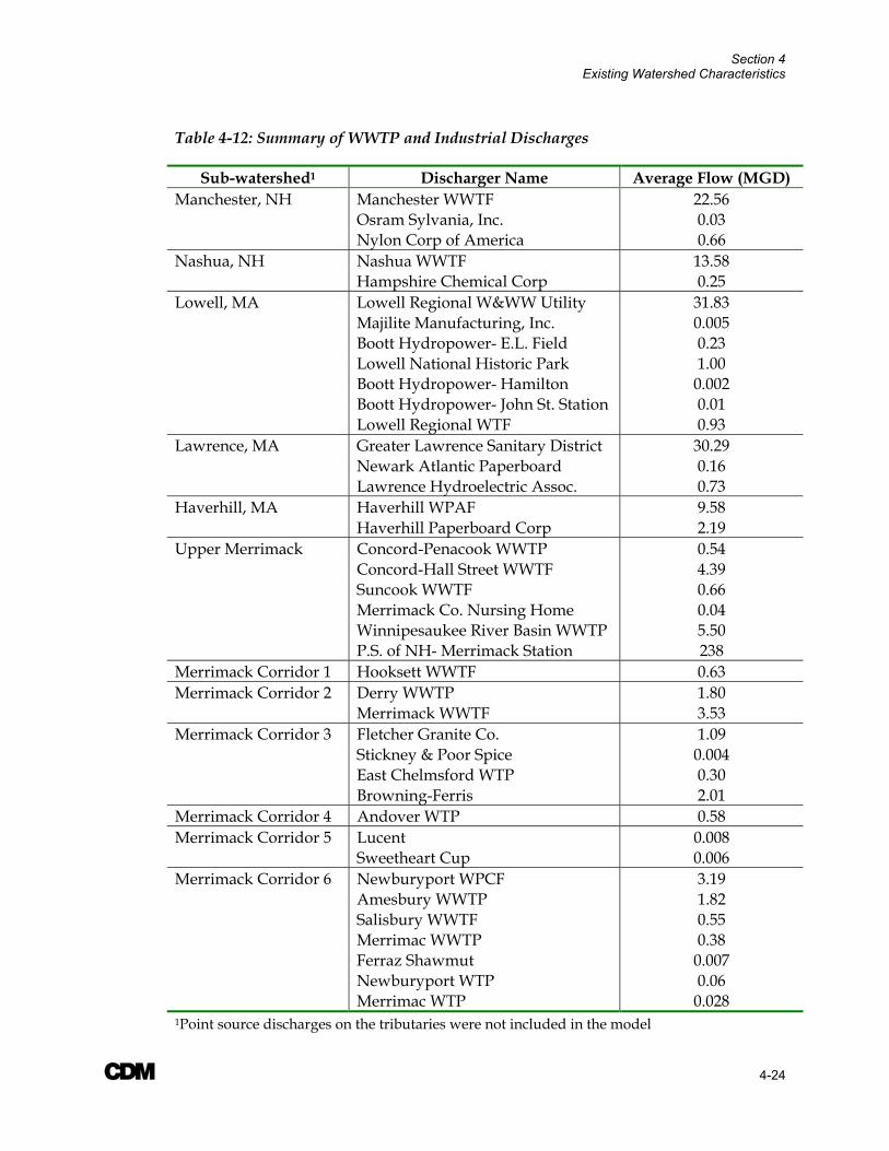
Section 4 Existing Watershed Characteristics
A 4-24
Table 4-12: Summary of WWTP and Industrial Discharges
Sub-watershed1 Discharger Name Average Flow (MGD) Manchester, NH Manchester WWTF 22.56 Osram Sylvania, Inc. 0.03 Nylon Corp of America 0.66 Nashua, NH Nashua WWTF 13.58 Hampshire Chemical Corp 0.25 Lowell, MA Lowell Regional W&WW Utility 31.83 Majilite Manufacturing, Inc. 0.005 Boott Hydropower- E.L. Field 0.23 Lowell National Historic Park 1.00 Boott Hydropower- Hamilton 0.002 Boott Hydropower- John St. Station 0.01 Lowell Regional WTF 0.93 Lawrence, MA Greater Lawrence Sanitary District 30.29 Newark Atlantic Paperboard 0.16 Lawrence Hydroelectric Assoc. 0.73 Haverhill, MA Haverhill WPAF 9.58 Haverhill Paperboard Corp 2.19 Upper Merrimack Concord-Penacook WWTP 0.54 Concord-Hall Street WWTF 4.39 Suncook WWTF 0.66 Merrimack Co. Nursing Home 0.04 Winnipesaukee River Basin WWTP 5.50 P.S. of NH- Merrimack Station 238 Merrimack Corridor 1 Hooksett WWTF 0.63 Merrimack Corridor 2 Derry WWTP 1.80 Merrimack WWTF 3.53 Merrimack Corridor 3 Fletcher Granite Co. 1.09 Stickney & Poor Spice 0.004 East Chelmsford WTP 0.30 Browning-Ferris 2.01 Merrimack Corridor 4 Andover WTP 0.58 Merrimack Corridor 5 Lucent 0.008 Sweetheart Cup 0.006 Merrimack Corridor 6 Newburyport WPCF 3.19 Amesbury WWTP 1.82 Salisbury WWTF 0.55 Merrimac WWTP 0.38 Ferraz Shawmut 0.007 Newburyport WTP 0.06 Merrimac WTP 0.028 1Point source discharges on the tributaries were not included in the model
Section 4 Existing Watershed Characteristics
A 4-25
4.7 On-site Wastewater Disposal Systems Septic systems are used for the subsurface disposal of wastewater, particularly in residential developments. These systems typically have a useful life expectancy and failures are known to occur, causing localized water quality problems. However, even properly operating septic systems may cause adverse impacts on water quality. Conventional septic systems are designed primarily for the removal of pathogens; thus even well-maintained systems provide minimal treatment of other constituents, such as nutrients, which may contribute to non-point source pollution.
The following section provides a summary of the percentage of the medium density residential land use category in the Merrimack River sub-basins serviced by septic systems, as well as the pollutant loading from these systems for the constituents of concern.
4.7.1 Summary of Watershed Area Serviced by Septic Systems Information on the number of septic systems in the Merrimack River watershed was collected under Task 2C of the Merrimack River Watershed Assessment Study and presented in the DRAFT “Summary of Information on Pollutant Sources” Report, dated September 2003. This information was obtained from the 1990 U.S. Census, which provided information on number of housing units serviced by septic systems on a town or county-wide basis.
To evaluate the impact of failing septic systems on non-point source pollution, the Watershed Management Model requires an estimate of the total land area in the low, medium, and high residential land use categories that are serviced by septic systems. For the purposes of the Merrimack model, data was not available basin-wide on the total residential land use category with septic systems. Thus, a one-to-one ratio was assumed between the percentage of housing units with septic systems (collected under Task 2C) and the percentage of residential land use with septic systems. As previously mentioned, all residential land use in the Merrimack watershed was assumed to be “medium” density.
Table 4-13 provides a summary of the input to WMM on percentage of residential land area serviced by septic systems for each sub-watershed. For the five sponsor communities, information was collected directly for each of the respective cities from the U.S. Census data. For the other sub-watersheds, an area-weighted average was developed based on the estimated number of septic system in each county (from the U.S. Census) and the percentage of the sub-basin area intersecting each county.

Section 4 Existing Watershed Characteristics
A 4-26
Table 4-13: Summary of Population, Housing, and Septic System Statistics
Category Sub-Watershed Population Housing
Units People per Household
Medium Density
Land Use (mi2)
Percentage of area
serviced by septic
systems Manchester, NH 99,567 44,361 2.2 11.1 5.4% Sponsor
Communities Nashua, NH 79,662 33,383 2.4 8.75 5.5% Lowell, MA 103,439 40,302 2.6 7.63 1.2% Lawrence, MA 70,207 26,915 2.6 4.01 1.0% Haverhill, MA 51,418 21,321 2.4 7.32 11.2%
Merrimack Corridor 1 7,967 3,332 2.4 1.78 47.4% Mainstem Merrimack Merrimack Corridor 2 45,986 18,862 2.4 6.83 38.0% Merrimack Corridor 3 93,921 37,611 2.5 5.30 24.8% Merrimack Corridor 4 146,121 58,373 2.5 7.84 19.4% Merrimack Corridor 5 181,831 72,868 2.5 6.61 19.2% Merrimack Corridor 6 52,098 21,212 2.5 9.31 33.3%
Upper Merrimack 221,140 94,687 2.3 34.2 47.4% Major Tributaries Assabet River 202,682 78,975 2.6 24.4 24.3% Beaver Brook 46,434 18,699 2.5 21.8 46.6% Cohas Brook 22,704 9,366 2.4 2.23 53.1% Concord River 99,026 38,507 2.6 15.7 19.0% Upper Nashua River 199,598 78,122 2.6 7.57 25.3% Lower Nashua River 130,229 51,074 2.5 22.8 30.2% Pemigewasset River 55,810 30,916 1.8 14.5 54.9% Piscataquog River 76,869 31,071 2.5 3.49 33.6% Powwow River 30,982 12,708 2.4 5.09 50.5% Salmon Brook 40,769 15,901 2.6 0.46 22.6% Shawsheen River 120,778 47,427 2.5 26.5 18.7% Souhegan River 87,334 35,142 2.5 9.31 31.8% Spickett River 37,297 15,314 2.4 10.6 51.5% Stony Brook 71,368 27,758 2.6 6.38 19.9% Sudbury River 235,393 91,592 2.6 37.0 21.1% Winnipesaukee River 43,088 26,538 1.6 31.6 63.8%
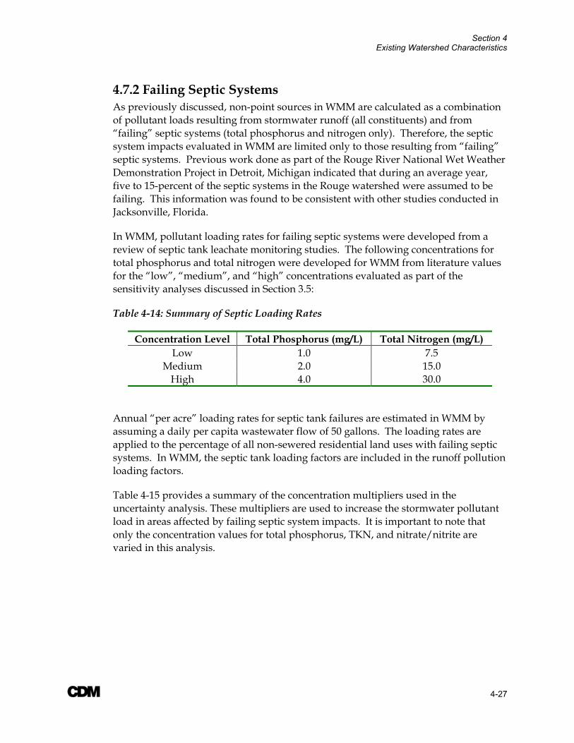
Section 4 Existing Watershed Characteristics
A 4-27
4.7.2 Failing Septic Systems As previously discussed, non-point sources in WMM are calculated as a combination of pollutant loads resulting from stormwater runoff (all constituents) and from “failing” septic systems (total phosphorus and nitrogen only). Therefore, the septic system impacts evaluated in WMM are limited only to those resulting from “failing” septic systems. Previous work done as part of the Rouge River National Wet Weather Demonstration Project in Detroit, Michigan indicated that during an average year, five to 15-percent of the septic systems in the Rouge watershed were assumed to be failing. This information was found to be consistent with other studies conducted in Jacksonville, Florida.
In WMM, pollutant loading rates for failing septic systems were developed from a review of septic tank leachate monitoring studies. The following concentrations for total phosphorus and total nitrogen were developed for WMM from literature values for the “low”, “medium”, and “high” concentrations evaluated as part of the sensitivity analyses discussed in Section 3.5:
Table 4-14: Summary of Septic Loading Rates
Concentration Level Total Phosphorus (mg/L) Total Nitrogen (mg/L) Low 1.0 7.5
Medium 2.0 15.0 High 4.0 30.0
Annual “per acre” loading rates for septic tank failures are estimated in WMM by assuming a daily per capita wastewater flow of 50 gallons. The loading rates are applied to the percentage of all non-sewered residential land uses with failing septic systems. In WMM, the septic tank loading factors are included in the runoff pollution loading factors.
Table 4-15 provides a summary of the concentration multipliers used in the uncertainty analysis. These multipliers are used to increase the stormwater pollutant load in areas affected by failing septic system impacts. It is important to note that only the concentration values for total phosphorus, TKN, and nitrate/nitrite are varied in this analysis.
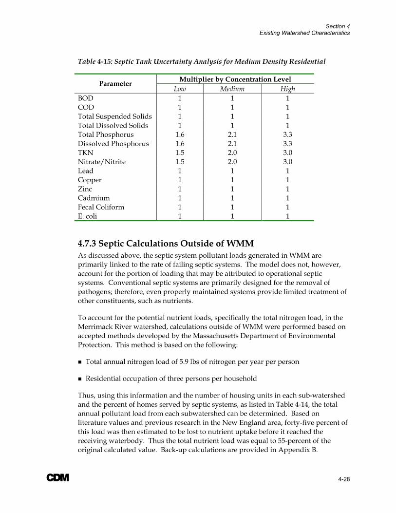
Section 4 Existing Watershed Characteristics
A 4-28
Table 4-15: Septic Tank Uncertainty Analysis for Medium Density Residential
Multiplier by Concentration Level Parameter Low Medium High
BOD 1 1 1 COD 1 1 1 Total Suspended Solids 1 1 1 Total Dissolved Solids 1 1 1 Total Phosphorus 1.6 2.1 3.3 Dissolved Phosphorus 1.6 2.1 3.3 TKN 1.5 2.0 3.0 Nitrate/Nitrite 1.5 2.0 3.0 Lead 1 1 1 Copper 1 1 1 Zinc 1 1 1 Cadmium 1 1 1 Fecal Coliform 1 1 1 E. coli 1 1 1
4.7.3 Septic Calculations Outside of WMM As discussed above, the septic system pollutant loads generated in WMM are primarily linked to the rate of failing septic systems. The model does not, however, account for the portion of loading that may be attributed to operational septic systems. Conventional septic systems are primarily designed for the removal of pathogens; therefore, even properly maintained systems provide limited treatment of other constituents, such as nutrients.
To account for the potential nutrient loads, specifically the total nitrogen load, in the Merrimack River watershed, calculations outside of WMM were performed based on accepted methods developed by the Massachusetts Department of Environmental Protection. This method is based on the following:
Total annual nitrogen load of 5.9 lbs of nitrogen per year per person
Residential occupation of three persons per household
Thus, using this information and the number of housing units in each sub-watershed and the percent of homes served by septic systems, as listed in Table 4-14, the total annual pollutant load from each subwatershed can be determined. Based on literature values and previous research in the New England area, forty-five percent of this load was then estimated to be lost to nutrient uptake before it reached the receiving waterbody. Thus the total nutrient load was equal to 55-percent of the original calculated value. Back-up calculations are provided in Appendix B.
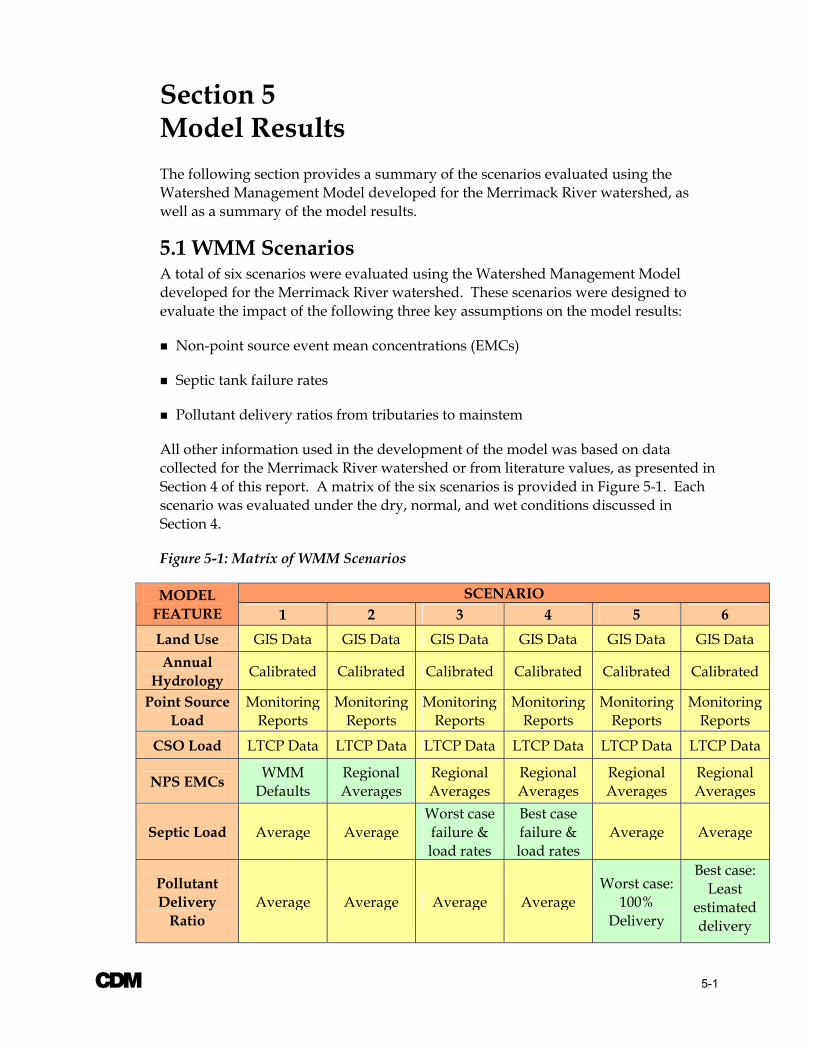
A 5-1
Section 5 Model Results The following section provides a summary of the scenarios evaluated using the Watershed Management Model developed for the Merrimack River watershed, as well as a summary of the model results.
5.1 WMM Scenarios A total of six scenarios were evaluated using the Watershed Management Model developed for the Merrimack River watershed. These scenarios were designed to evaluate the impact of the following three key assumptions on the model results:
Non-point source event mean concentrations (EMCs)
Septic tank failure rates
Pollutant delivery ratios from tributaries to mainstem
All other information used in the development of the model was based on data collected for the Merrimack River watershed or from literature values, as presented in Section 4 of this report. A matrix of the six scenarios is provided in Figure 5-1. Each scenario was evaluated under the dry, normal, and wet conditions discussed in Section 4.
Figure 5-1: Matrix of WMM Scenarios
SCENARIO MODEL FEATURE 1 2 3 4 5 6 Land Use GIS Data GIS Data GIS Data GIS Data GIS Data GIS Data Annual
Hydrology Calibrated Calibrated Calibrated Calibrated Calibrated Calibrated
Point Source Load
Monitoring Reports
Monitoring Reports
Monitoring Reports
Monitoring Reports
Monitoring Reports
Monitoring Reports
CSO Load LTCP Data LTCP Data LTCP Data LTCP Data LTCP Data LTCP Data
NPS EMCs WMM Defaults
Regional Averages
Regional Averages
Regional Averages
Regional Averages
Regional Averages
Septic Load Average Average Worst case failure & load rates
Best case failure & load rates
Average Average
Pollutant Delivery
Ratio Average Average Average Average
Worst case: 100%
Delivery
Best case: Least
estimated delivery
Section 5 Model Results
A 5-2
5.1.1 Scenario 1 & 2- Event Mean Concentrations The WMM default and regional average EMC values used in Scenarios 1 and 2, respectively, are presented in Table 4-4. As noted in Section 4.3, regional values were not available for the following land use types: agriculture/pasture, forest/rural open, highway, urban open, and water/wetlands. In these cases, the WMM default values were used in both Scenario 1 and 2. Therefore, only the EMC values for commercial, industrial, and medium density residential land uses differed between the two scenarios.
In both scenarios, an average septic failure rate of seven-percent and an average pollutant delivery ratio of 50-percent were used.
5.1.2 Scenario 3 & 4- Septic Impact A summary of information on septic system failure rates was presented in the DRAFT “Summary of Information on Pollutant Sources” Report, dated September 2003. As summarized in this report, a review of the available literature did not reveal any information regarding septic system failure rates for communities in the Merrimack River watershed. However, previous work done as part of the Rouge River National Wet Weather Demonstration Project in Detroit, Michigan indicated that during an average year, five to 15-percent of the septic systems in the Rouge watershed were assumed to be failing. Thus, for the Merrimack study, a three-percent failure rate was assumed for the “best case” scenario (Scenario 4) and a 15-percent failure rate was assumed for the “worst case” scenario (Scenario 3).
In both Scenario 3 and 4, the regional EMC values were used and an average pollutant delivery ratio of 50-percent was assumed.
5.1.3 Scenario 5 & 6- Pollutant Delivery Ratio In WMM, a pollutant delivery ratio is applied to each sub-watershed to account for the reduction in runoff pollutant load due to uptake or removal in stream courses. Under the “worst-case” conditions (Scenario 5), a pollutant delivery ratio of 100% was assumed, meaning that 100-percent of the pollutant load running off the land entered the river channel and made it to the downstream most point in the channel.
Under the “best-case” scenario (Scenario 6), a varied pollutant delivery ratio was estimated based on the size of the watershed, according to the criteria provided in Table 5-1. It was assumed that larger watersheds would have smaller delivery ratios, since it would take a proportionally longer period of time for the pollutant to reach the river channel and the downstream most point in the watershed.
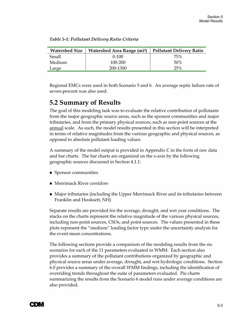
Section 5 Model Results
A 5-3
Table 5-1: Pollutant Delivery Ratio Criteria
Watershed Size Watershed Area Range (mi2) Pollutant Delivery Ratio Small 0-100 75% Medium 100-200 50% Large 200-1300 25%
Regional EMCs were used in both Scenario 5 and 6. An average septic failure rate of seven-percent was also used.
5.2 Summary of Results The goal of this modeling task was to evaluate the relative contribution of pollutants from the major geographic source areas, such as the sponsor communities and major tributaries, and from the primary physical sources, such as non-point sources at the annual scale. As such, the model results presented in this section will be interpreted in terms of relative magnitudes from the various geographic and physical sources, as opposed to absolute pollutant loading values.
A summary of the model output is provided in Appendix C in the form of raw data and bar charts. The bar charts are organized on the x-axis by the following geographic sources discussed in Section 4.1.1:
Sponsor communities
Merrimack River corridors
Major tributaries (including the Upper Merrimack River and its tributaries between Franklin and Hooksett, NH)
Separate results are provided for the average, drought, and wet year conditions. The stacks on the charts represent the relative magnitude of the various physical sources, including non-point sources, CSOs, and point sources. The values presented in these plots represent the “medium” loading factor type under the uncertainty analysis for the event mean concentrations.
The following sections provide a comparison of the modeling results from the six scenarios for each of the 11 parameters evaluated in WMM. Each section also provides a summary of the pollutant contributions organized by geographic and physical source areas under average, drought, and wet hydrologic conditions. Section 6.0 provides a summary of the overall WMM findings, including the identification of overriding trends throughout the suite of parameters evaluated. Pie charts summarizing the results from the Scenario 6 model runs under average conditions are also provided.
Section 5 Model Results
A 5-4
5.2.1 Flow The WMM results suggest that of the three major physical sources evaluated in this study, non-point sources are the largest contributor to total annual flow in the Merrimack River watershed under each of the three hydrologic conditions evaluated. However, it is important to note that this study did not evaluate baseflow contributions, which would most likely be the dominant source of streamflow in the Merrimack River. Point sources contribute the next largest percentage of annual flow, while CSO discharges are a fairly insignificant source. From a geographic perspective, the tributaries provide the vast majority of the streamflow (over 80-percent), with sponsor communities and Merrimack River corridors splitting the remaining approximately 20-percent.
Table 5-2 provides a summary of the total annual flow contributions from the various physical and geographic sources under the three hydrologic conditions evaluated in this study: drought, average, and wet years.
Table 5-2: Summary of total annual flow contributions under drought, average, and wet hydrologic conditions (values are percent of total)
Geographic Sources Physical Sources Hydrologic Condition Communities MR
Corridors Tribs NPS1 Point Source CSOs
Average 7% 7% 86% 76% 24% 0.1% Drought 11% 7% 83% 65% 35% 0.2%
Wet 5% 7% 88% 83% 17% 0.1% 1Includes stormwater runoff and septic system impacts 2Values have been rounded to the nearest whole number
Bar charts of the WMM flow results organized by geographic source areas are provided in Appendix C (pages C.1, C. 7, C.13, C.19, C.25, and C.31).
5.2.2 Fecal Coliform In general, non-point sources in the major tributaries dominated the annual fecal coliform loads in the Merrimack River watershed in each of the six scenarios evaluated as part of this study. This theme was common among the three hydrologic conditions evaluated with WMM.
In the sponsor communities, the highest fecal coliform loads consistently resulted from the CSOs, with point sources as the next largest source. It is important to note here that WMM assumes that 100-percent of a watershed with combined sewers is converted to CSO discharge; as such, there is no non-point source load from the five sponsor communities. This is only a rough approximation in the Merrimack River watershed, as each of the communities has some (small) portion of their runoff discharging to separated stormdrains.
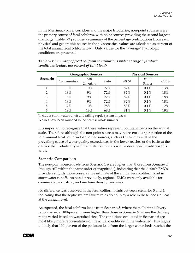
Section 5 Model Results
A 5-5
In the Merrimack River corridors and the major tributaries, non-point sources were the primary source of fecal coliform, with point sources providing the second largest discharge. Table 5-3 provides a summary of the percentage contributions from each physical and geographic source in the six scenarios; values are calculated as percent of the total annual fecal coliform load. Only values for the “average” hydrologic conditions are presented.
Table 5-3: Summary of fecal coliform contributions under average hydrologic conditions (values are percent of total load)
Geographic Sources Physical Sources Scenario
Communities MR Corridors Tribs NPS1 Point
Source CSOs
1 13% 10% 77% 87% 0.1% 13% 2 18% 9% 72% 82% 0.1% 18% 3 18% 9% 72% 82% 0.1% 18% 4 18% 9% 72% 82% 0.1% 18% 5 12% 10% 78% 88% 0.1% 12% 6 19% 13% 68% 81% 0.1% 19%
1Includes stormwater runoff and failing septic system impacts 2Values have been rounded to the nearest whole number
It is important to recognize that these values represent pollutant loads on the annual scale. Therefore, although the non-point sources may represent a larger portion of the total annual fecal coliform load, other sources, such as CSOs, may still be the prevailing cause of water quality exceedances in the lower reaches of the basin at the daily-scale. Detailed dynamic simulation models will be developed to address this issue.
Scenario Comparison The non-point source loads from Scenario 1 were higher than those from Scenario 2 (though still within the same order of magnitude), indicating that the default EMCs provide a slightly more conservative estimate of the annual fecal coliform load in stormwater runoff. As noted previously, regional EMCs were only available for commercial, industrial, and medium density land uses.
No difference was observed in the fecal coliform loads between Scenarios 3 and 4, indicating that the septic system failure rates do not play a role in these loads, at least at the annual level.
As expected, the fecal coliform loads from Scenario 5, where the pollutant delivery ratio was set at 100-percent, were higher than those in Scenario 6, where the delivery ratios varied based on watershed size. The conditions evaluated in Scenario 6 are most likely more representative of the actual conditions in the watershed. It is highly unlikely that 100-percent of the pollutant load from the larger watersheds reaches the
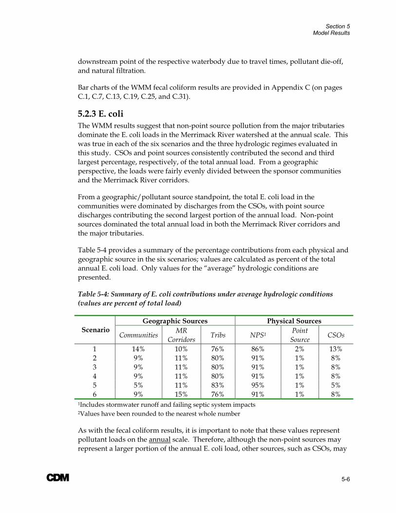
Section 5 Model Results
A 5-6
downstream point of the respective waterbody due to travel times, pollutant die-off, and natural filtration.
Bar charts of the WMM fecal coliform results are provided in Appendix C (on pages C.1, C.7, C.13, C.19, C.25, and C.31).
5.2.3 E. coli The WMM results suggest that non-point source pollution from the major tributaries dominate the E. coli loads in the Merrimack River watershed at the annual scale. This was true in each of the six scenarios and the three hydrologic regimes evaluated in this study. CSOs and point sources consistently contributed the second and third largest percentage, respectively, of the total annual load. From a geographic perspective, the loads were fairly evenly divided between the sponsor communities and the Merrimack River corridors.
From a geographic/pollutant source standpoint, the total E. coli load in the communities were dominated by discharges from the CSOs, with point source discharges contributing the second largest portion of the annual load. Non-point sources dominated the total annual load in both the Merrimack River corridors and the major tributaries.
Table 5-4 provides a summary of the percentage contributions from each physical and geographic source in the six scenarios; values are calculated as percent of the total annual E. coli load. Only values for the “average” hydrologic conditions are presented.
Table 5-4: Summary of E. coli contributions under average hydrologic conditions (values are percent of total load)
Geographic Sources Physical Sources Scenario
Communities MR Corridors Tribs NPS1 Point
Source CSOs
1 14% 10% 76% 86% 2% 13% 2 9% 11% 80% 91% 1% 8% 3 9% 11% 80% 91% 1% 8% 4 9% 11% 80% 91% 1% 8% 5 5% 11% 83% 95% 1% 5% 6 9% 15% 76% 91% 1% 8%
1Includes stormwater runoff and failing septic system impacts 2Values have been rounded to the nearest whole number
As with the fecal coliform results, it is important to note that these values represent pollutant loads on the annual scale. Therefore, although the non-point sources may represent a larger portion of the annual E. coli load, other sources, such as CSOs, may
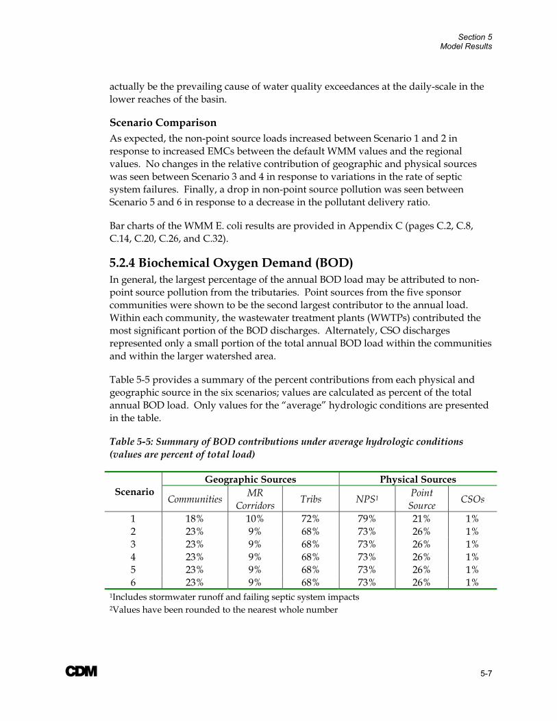
Section 5 Model Results
A 5-7
actually be the prevailing cause of water quality exceedances at the daily-scale in the lower reaches of the basin.
Scenario Comparison As expected, the non-point source loads increased between Scenario 1 and 2 in response to increased EMCs between the default WMM values and the regional values. No changes in the relative contribution of geographic and physical sources was seen between Scenario 3 and 4 in response to variations in the rate of septic system failures. Finally, a drop in non-point source pollution was seen between Scenario 5 and 6 in response to a decrease in the pollutant delivery ratio.
Bar charts of the WMM E. coli results are provided in Appendix C (pages C.2, C.8, C.14, C.20, C.26, and C.32).
5.2.4 Biochemical Oxygen Demand (BOD) In general, the largest percentage of the annual BOD load may be attributed to non-point source pollution from the tributaries. Point sources from the five sponsor communities were shown to be the second largest contributor to the annual load. Within each community, the wastewater treatment plants (WWTPs) contributed the most significant portion of the BOD discharges. Alternately, CSO discharges represented only a small portion of the total annual BOD load within the communities and within the larger watershed area.
Table 5-5 provides a summary of the percent contributions from each physical and geographic source in the six scenarios; values are calculated as percent of the total annual BOD load. Only values for the “average” hydrologic conditions are presented in the table.
Table 5-5: Summary of BOD contributions under average hydrologic conditions (values are percent of total load)
Geographic Sources Physical Sources Scenario
Communities MR Corridors Tribs NPS1 Point
Source CSOs
1 18% 10% 72% 79% 21% 1% 2 23% 9% 68% 73% 26% 1% 3 23% 9% 68% 73% 26% 1% 4 23% 9% 68% 73% 26% 1% 5 23% 9% 68% 73% 26% 1% 6 23% 9% 68% 73% 26% 1%
1Includes stormwater runoff and failing septic system impacts 2Values have been rounded to the nearest whole number

Section 5 Model Results
A 5-8
Scenario Comparison As shown in Table 5-5, the non-point source load in Scenario 1 was higher than that in Scenario 2, indicating the that WMM default EMCs (Scenario 1) provide a slightly more conservative estimate of the BOD loads. In general, the relative BOD loads were not impacted by changes to the failing septic system rates (Scenarios 3 and 4) or changes to the delivery ratios (Scenario 5 and 6).
Bar charts of the WMM BOD results are provided in Appendix C (pages C.2, C.8, C.14, C.20, C.26, and C.32).
5.2.5 Total Phosphorus The WMM results suggest that the annual phosphorus loads in the Merrimack River watershed are dominated by point source discharges from the sponsor communities. Although WWTPs are the largest dischargers in each of the communities, it is important to note that no total phosphorus monitoring data was available for the treatment plants. As discussed in Section 4.6, an average discharge concentration of 3mg/L was assumed for each WWTP and then a flow-weighted average was calculated for the sub-watershed. Future modeling studies will be better able to define the total phosphorus contributions from the WWTPs. Additionally, effluent samples collected from the sponsor community’s WWTPs during the three dry-weather sampling events were analyzed for total phosphorus.
In each of the six scenarios, stormwater runoff contributed the second largest percentage of the total annual phosphorus load. The majority of the phosphorus load in stormwater runoff may be attributed to the tributaries sources. The tributary loads were dominated by non-point source pollution, with point sources contributing only a small portion of the total load. In contrast, the point sources were a larger contributor than the point sources in the Merrimack River corridors. The annual septic system and CSO loads are inconsequential in comparison to the other loads.
Table 5-6 provides a summary of the percent contributions from each physical and geographic source in the six scenarios; values are calculated as percent of the annual total phosphorus load. Only values for the “average” hydrologic conditions are presented in the table.

Section 5 Model Results
A 5-9
Table 5-6: Summary of Total Phosphorus contributions under average hydrologic conditions (values are percent of total load)
Geographic Sources Physical Sources Scenario
Communities MR Corridors Tribs Stormwater
Runoff Point
Source CSOs Failing Septic
1 80% 5% 16% 14% 86% 0.2% 0.1% 2 81% 4% 14% 12% 87% 0.2% 0.1% 3 81% 5% 15% 12% 87% 0.2% 0.2% 4 81% 4% 14% 12% 87% 0.2% 0.1% 5 78% 5% 17% 16% 84% 0.2% 0.1% 6 82% 5% 13% 12% 88% 0.2% 0.1%
1Values have been rounded to the nearest whole number
Scenario Comparison As shown in Table 5-6, the total phosphorus loads calculated using the default WMM EMCs (Scenario 1) were higher than those calculated using the regional values (Scenario 2). In Scenarios 3 and 4, varying the rate of failing septic systems had minimal impact on the relative total phosphorus loads. Slightly higher septic loads were found at failure rates of 15-percent (Scenario 3). However, as noted previously, these loads were minor in comparison to those from other sources. As is expected, the stormwater loads decreased between Scenario 5 and 6, in response to changes in the pollutant delivery ratio.
Bar charts of the WMM total phosphorus results are provided in Appendix C (pages C.3, C.9, C.15, C.21, C.27, and C.33).
5.2.6 Total Nitrogen (Nitrate/ Nitrite + TKN) The results from WMM and manual calculations (see Section 4.7.3) suggest that annual total nitrogen loads are fairly evenly divided between point sources discharges from the communities and non-point sources from the tributaries. In general, failing septic systems and CSO discharges have very little impact on the overall pollutant load, together contributing less than one-percent of the total annual load. Non-failing septic contribute approximately 15-percent of the total annual load.
From a geographic perspective, the total nitrogen loads in tributaries are generally dominated by non-point source pollution, followed by septic discharges. In general, the largest septic load of the three geographic source areas comes from the tributary watersheds, which typically have a larger number of number of homes with private septic systems. Annual loads in the Merrimack River corridors are fairly equally divided between non-point sources, point sources, and operational septic systems. The total nitrogen load in the sponsor communities is dominated by point source discharges, the primary source of which is WWTPs. As with the total phosphorus data, it is important to note that no nitrogen monitoring data was available for the WWTPs. An average concentration of 3mg/L was assumed for the nitrate/nitrite

Section 5 Model Results
A 5-10
component and 15mg/L was assumed for the TKN component (Note: the total nitrogen load was calculated as the sum of the NO2/NO3 and TKN results). These values were based on accepted literature values and those used for similar point sources in the Rouge River National Wet Weather Demonstration Project. Flow-weight averages were developed for each sub-watershed using these values.
Table 5-7 provides a summary of the percent contributions from each physical and geographic source in the six scenarios; values are calculated as percent of the annual total nitrogen load. Only values for the “average” hydrologic conditions are presented in the table for those parameters calculated in WMM.
Table 5-7: Summary of Total Nitrogen contributions under average hydrologic conditions (values are percent of total load)
Geographic Sources Physical Sources Scenario
Communities MR
Corridors Tribs
Stormwater Runoff
Point Source
CSO Failing Septic
Septic (non WMM)
1 38% 10% 52% 40% 45% 0.2% 0.1% 15% 2 40% 10% 50% 37% 47% 0.2% 0.3% 15% 3 40% 10% 50% 37% 47% 0.2% 0.5% 15% 4 40% 10% 50% 37% 47% 0.2% 0.02% 15% 5 36% 10% 55% 44% 42% 0.2% 0.4% 14% 6 41% 11% 48% 35% 49% 0.2% 0.2% 16%
Scenario Comparison The stormwater runoff total nitrogen load was slightly higher in Scenario 1 using the default WMM EMC values, as compared to Scenario 2, where the regional EMC values were used. Little variation was seen in the results between Scenarios 3 and 4 in response to changes in the septic tank failure rates. Finally, as expected, the stormwater loads decreased between Scenario 5 and 6, in response to changes in the pollutant delivery ratio.
Bar charts of the WMM total nitrogen results are provided in Appendix C (pages C.3, C.9, C.15, C.21, C.27, and C.33).

Section 5 Model Results
A 5-11
5.2.7 Total Suspended Solids (TSS) In each of the six scenarios evaluated in WMM, non-point sources from the tributaries dominated the annual TSS load in the Merrimack River watershed. Point sources were the second largest physical source, with CSOs contributing only a small portion of the total annual load.
From a geographic standpoint, point source discharges dominated the pollutant loads from the five sponsor communities, while non-point sources were the predominate contributors to the annual TSS load in the tributaries and the Merrimack River corridors.
Table 5-8 provides a summary of the percent contributions from each physical and geographic source in the six scenarios; values are calculated as percent of the annual TSS load. Only values for the “average” hydrologic conditions are presented in the table.
Table 5-8: Summary of TSS contributions under average hydrologic conditions (values are percent of total load)
Geographic Sources Physical Sources Scenario
Communities MR Corridors Tribs NPS1 Point
Source CSOs
1 5% 8% 86% 90% 9% 1% 2 6% 8% 86% 89% 10% 1% 3 6% 8% 86% 89% 10% 1% 4 6% 8% 86% 89% 10% 1% 5 3% 8% 89% 94% 5% 0.5% 6 8% 15% 78% 86% 13% 1%
1Includes stormwater runoff and failing septic system impacts 2Values have been rounded to the nearest whole number
Scenario Comparison A minimal impact was seen between Scenarios 1 and 2 in the relative contribution of loads from the geographic and physical sources, indicating that there was little difference between the regional and default WMM values. No impact was seen in Scenarios 3 and 4 by varying the percentage of failing septic systems. As expected, the percent contribution from non-point sources dropped between Scenarios 5 and 6 as a result of changes to the pollutant delivery ratio. The percent contribution from the tributaries decreased in response to these changes.
Bar charts of the WMM total suspended solids results are provided in Appendix C (pages C.4, C.10, C.16, C.22, C.28, and C.34).
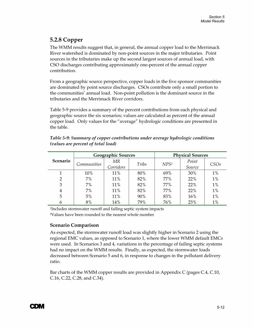
Section 5 Model Results
A 5-12
5.2.8 Copper The WMM results suggest that, in general, the annual copper load to the Merrimack River watershed is dominated by non-point sources in the major tributaries. Point sources in the tributaries make up the second largest sources of annual load, with CSO discharges contributing approximately one-percent of the annual copper contribution.
From a geographic source perspective, copper loads in the five sponsor communities are dominated by point source discharges. CSOs contribute only a small portion to the communities’ annual load. Non-point pollution is the dominant source in the tributaries and the Merrimack River corridors.
Table 5-9 provides a summary of the percent contributions from each physical and geographic source the six scenarios; values are calculated as percent of the annual copper load. Only values for the “average” hydrologic conditions are presented in the table.
Table 5-9: Summary of copper contributions under average hydrologic conditions (values are percent of total load)
Geographic Sources Physical Sources Scenario
Communities MR Corridors Tribs NPS1 Point
Source CSOs
1 10% 11% 80% 69% 30% 1% 2 7% 11% 82% 77% 22% 1% 3 7% 11% 82% 77% 22% 1% 4 7% 11% 82% 77% 22% 1% 5 5% 11% 90% 83% 16% 1% 6 8% 14% 79% 76% 23% 1%
1Includes stormwater runoff and failing septic system impacts 2Values have been rounded to the nearest whole number
Scenario Comparison As expected, the stormwater runoff load was slightly higher in Scenario 2 using the regional EMC values, as opposed to Scenario 1, where the lower WMM default EMCs were used. In Scenarios 3 and 4, variations in the percentage of failing septic systems had no impact on the WMM results. Finally, as expected, the stormwater loads decreased between Scenario 5 and 6, in response to changes in the pollutant delivery ratio.
Bar charts of the WMM copper results are provided in Appendix C (pages C.4, C.10, C.16, C.22, C.28, and C.34).
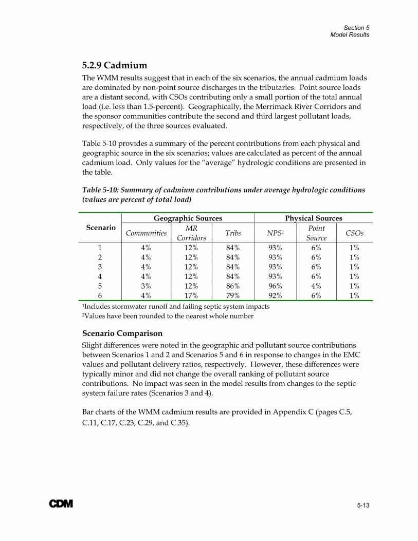
Section 5 Model Results
A 5-13
5.2.9 Cadmium The WMM results suggest that in each of the six scenarios, the annual cadmium loads are dominated by non-point source discharges in the tributaries. Point source loads are a distant second, with CSOs contributing only a small portion of the total annual load (i.e. less than 1.5-percent). Geographically, the Merrimack River Corridors and the sponsor communities contribute the second and third largest pollutant loads, respectively, of the three sources evaluated.
Table 5-10 provides a summary of the percent contributions from each physical and geographic source in the six scenarios; values are calculated as percent of the annual cadmium load. Only values for the “average” hydrologic conditions are presented in the table.
Table 5-10: Summary of cadmium contributions under average hydrologic conditions (values are percent of total load)
Geographic Sources Physical Sources Scenario
Communities MR Corridors Tribs NPS1 Point
Source CSOs
1 4% 12% 84% 93% 6% 1% 2 4% 12% 84% 93% 6% 1% 3 4% 12% 84% 93% 6% 1% 4 4% 12% 84% 93% 6% 1% 5 3% 12% 86% 96% 4% 1% 6 4% 17% 79% 92% 6% 1%
1Includes stormwater runoff and failing septic system impacts 2Values have been rounded to the nearest whole number
Scenario Comparison Slight differences were noted in the geographic and pollutant source contributions between Scenarios 1 and 2 and Scenarios 5 and 6 in response to changes in the EMC values and pollutant delivery ratios, respectively. However, these differences were typically minor and did not change the overall ranking of pollutant source contributions. No impact was seen in the model results from changes to the septic system failure rates (Scenarios 3 and 4).
Bar charts of the WMM cadmium results are provided in Appendix C (pages C.5, C.11, C.17, C.23, C.29, and C.35).

Section 5 Model Results
A 5-14
5.2.10 Lead In each of the six scenarios evaluated with WMM, the total annual lead load in the Merrimack River watershed was dominated by non-point source pollution from the tributaries. Point sources and CSO discharge each contribute less than two-percent of the total annual load.
From a geographic perspective, the annual lead loads in the sponsor communities are split fairly evenly between CSO and point source contributions. Non-point sources are the dominant contributors in the both the tributaries and the Merrimack River corridors.
Table 5-11 provides a summary of the percent contributions from each physical and geographic source in the six scenarios; values are calculated as percent of the annual lead load. Only values for the “average” hydrologic conditions are presented in the table.
Table 5-11: Summary of lead contributions under average hydrologic conditions (values are percent of total load)
Geographic Sources Physical Sources Scenario
Communities MR Corridors Tribs NPS1 Point
Source CSOs
1 3% 11% 86% 97% 2% 2% 2 2% 11 % 86% 97% 2% 1% 3 2% 11% 86% 97% 2% 1% 4 2% 11% 86% 97% 2% 1% 5 1% 11% 87% 98% 1% 1% 6 3% 17% 80% 97% 2% 1%
1Includes stormwater runoff and failing septic system impacts 2Values have been rounded to the nearest whole number
Scenario Comparison Unlike the other constituents, the non-point source load in Scenario 1 was lower than that in Scenario 2 where the regional EMC values were used. This is to be expected, as higher regional EMCs were used in the model for commercial land uses. In Scenarios 3 and 4, variations in the rate of failing septic systems had no impact on the relative geographic or physical source contributions. Only minor variations in the relative contribution of annual pollutant lead loads were observed between Scenario 5 and 6. As expected, a slight drop in the non-point source load was seen between Scenario 5 and 6.
Bar charts of the WMM lead results are provided in Appendix C (pages C.5, C.11, C.17, C.23, C.29, and C.35).
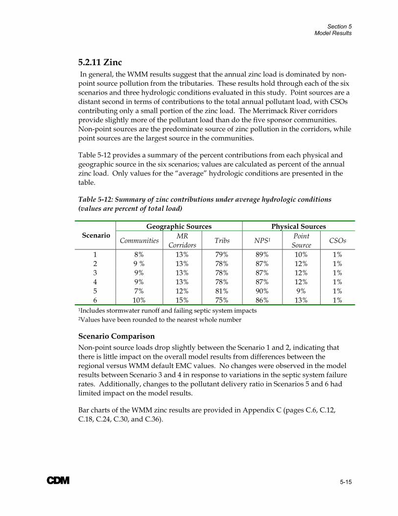
Section 5 Model Results
A 5-15
5.2.11 Zinc In general, the WMM results suggest that the annual zinc load is dominated by non-point source pollution from the tributaries. These results hold through each of the six scenarios and three hydrologic conditions evaluated in this study. Point sources are a distant second in terms of contributions to the total annual pollutant load, with CSOs contributing only a small portion of the zinc load. The Merrimack River corridors provide slightly more of the pollutant load than do the five sponsor communities. Non-point sources are the predominate source of zinc pollution in the corridors, while point sources are the largest source in the communities.
Table 5-12 provides a summary of the percent contributions from each physical and geographic source in the six scenarios; values are calculated as percent of the annual zinc load. Only values for the “average” hydrologic conditions are presented in the table.
Table 5-12: Summary of zinc contributions under average hydrologic conditions (values are percent of total load)
Geographic Sources Physical Sources Scenario
Communities MR Corridors Tribs NPS1 Point
Source CSOs
1 8% 13% 79% 89% 10% 1% 2 9 % 13% 78% 87% 12% 1% 3 9% 13% 78% 87% 12% 1% 4 9% 13% 78% 87% 12% 1% 5 7% 12% 81% 90% 9% 1% 6 10% 15% 75% 86% 13% 1%
1Includes stormwater runoff and failing septic system impacts 2Values have been rounded to the nearest whole number
Scenario Comparison Non-point source loads drop slightly between the Scenario 1 and 2, indicating that there is little impact on the overall model results from differences between the regional versus WMM default EMC values. No changes were observed in the model results between Scenario 3 and 4 in response to variations in the septic system failure rates. Additionally, changes to the pollutant delivery ratio in Scenarios 5 and 6 had limited impact on the model results.
Bar charts of the WMM zinc results are provided in Appendix C (pages C.6, C.12, C.18, C.24, C.30, and C.36).

Section 5 Model Results
A 5-16
5.3 Sensitivity Analysis to Percent Imperviousness As discussed in Section 4.2, a sensitivity analysis was performed to evaluate the impact of the estimated percent imperviousness for the highway land use category on the overall model results. This land use category makes up less than one-percent of the total area of the Merrimack River watershed.
As part of this analysis, the calibrated model was re-run for Scenario 1 and 5 under average conditions using a revised percent imperviousness of 55-percent, rather than the default value of five-percent. As expected, the annual pollutant loads increased in response to the higher percent imperviousness. In general, an increase of between 0 and 15-percent was observed, depending on the constituent. This increase does not substantially impact the overall study conclusions with respect to the relative contribution of pollutant loads from geographic and physical source areas in the basin. Therefore, it may be concluded that the Watershed Management Model developed for the Merrimack River watershed is fairly insensitive to an increase in the percent imperviousness for the highway land use category.
Furthermore, as discussed in Section 4.2, the percent DCIA is expected to be much lower than the 55-percent imperviousness used as the upper bound in this sensitivity analysis. In general, for most highway systems, very few stormdrains are connected to highway pavement. Most major interstates convey stormwater runoff via overland flow to an undeveloped drain system, such as a roadside vegetated swale, and have only a limited number of catchbasins collecting runoff at bridges and in urban areas. This results in a much lower percentage of impervious area that is directly connected to the hydraulic system; this value is reflected in the default WMM percent impervious values.
A 6-1
Section 6 Summary of Findings The Watershed Management Model (WMM) was used to evaluate the relative contribution of pollutant sources from various geographic and physical sources in the watershed. A total of six scenarios were evaluated for 11 parameters of concern (including flow). The scenarios were designed to evaluate the sensitivity of the WMM results to key assumptions, including EMC values, septic tank failure rates, and pollutant delivery ratios. The following section provides a summary of the significant model findings.
It is important to recognize that the WMM results represent pollutant loads at the annual scale. Therefore, these results are not necessarily indicative of water quality conditions at the scale on which water quality exceedances are measured.
6.1 Relative Contribution of Physical and Geographic Sources The WMM results suggest that, at the annual scale, non-point sources from the major tributaries typically dominate the pollutant loads for the eight of the 10 constituents evaluated in this study; the exceptions were the annual nutrient loads for nitrogen and phosphorus. These results were consistent across the six scenarios and three hydrologic regimes evaluated as part of this study. This finding is not surprising, as both the tributaries and the non-point sources are the largest contributors to total flow in the Merrimack River, as analyzed the respective geographic and physical sources.
The WMM results suggest that the annual total phosphorus loads were dominated by point sources in the communities (primarily WWTPs). The results suggest that for total nitrogen, the annual loads were fairly evenly split between point source discharges in the communities and non-point sources in the tributaries. It is important to note, however, that no monitoring data was available for total phosphorus or total nitrogen effluent concentrations at the WWTPs. Therefore, an assumed total phosphorus discharge concentration of 3.0 mg/L was used for all WWTPs. Similarly for the total nitrogen analysis, an average effluent concentration of 3.0 mg/L was assumed for the nitrate/nitrite component and 15 mg/L was assumed for the TKN component (Note: the total nitrogen load was calculated as the sum of the NO2/NO3 and TKN results). As previously discussed these concentrations were based on literature values. However, WWTP effluent samples from the five sponsor communities were analyzed for total phosphorus, TKN, and nitrate/nitrite during the three dry-weather sampling event conducted during the summer and early fall of 2003. These monitoring data will be used in lieu of literature values during the development of the more detailed models in subsequent tasks.
It is interesting to note that, according to the WMM results, the CSO discharges generally play a very small role in the annual pollutant loadings to the Merrimack River mainstem for the 10 constituents evaluated in this study. They were most
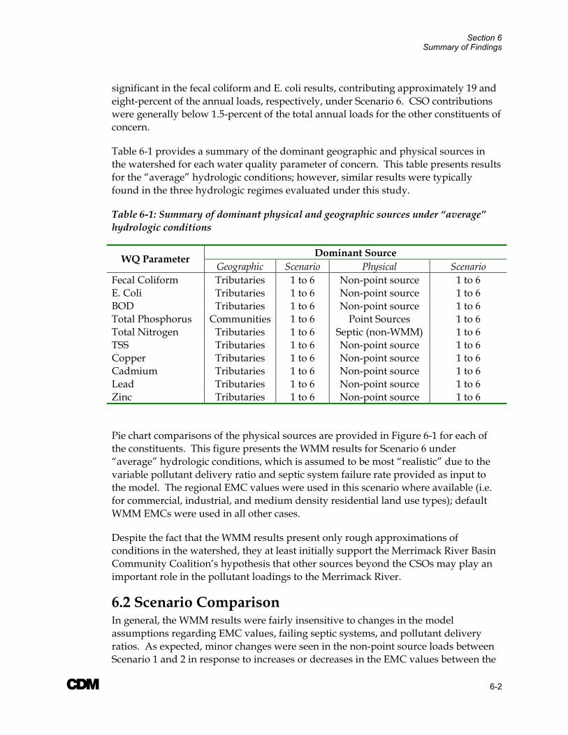
Section 6 Summary of Findings
A 6-2
significant in the fecal coliform and E. coli results, contributing approximately 19 and eight-percent of the annual loads, respectively, under Scenario 6. CSO contributions were generally below 1.5-percent of the total annual loads for the other constituents of concern.
Table 6-1 provides a summary of the dominant geographic and physical sources in the watershed for each water quality parameter of concern. This table presents results for the “average” hydrologic conditions; however, similar results were typically found in the three hydrologic regimes evaluated under this study.
Table 6-1: Summary of dominant physical and geographic sources under “average” hydrologic conditions
Dominant Source WQ Parameter Geographic Scenario Physical Scenario
Fecal Coliform Tributaries 1 to 6 Non-point source 1 to 6 E. Coli Tributaries 1 to 6 Non-point source 1 to 6 BOD Tributaries 1 to 6 Non-point source 1 to 6 Total Phosphorus Communities 1 to 6 Point Sources 1 to 6 Total Nitrogen Tributaries 1 to 6 Septic (non-WMM) 1 to 6 TSS Tributaries 1 to 6 Non-point source 1 to 6 Copper Tributaries 1 to 6 Non-point source 1 to 6 Cadmium Tributaries 1 to 6 Non-point source 1 to 6 Lead Tributaries 1 to 6 Non-point source 1 to 6 Zinc Tributaries 1 to 6 Non-point source 1 to 6
Pie chart comparisons of the physical sources are provided in Figure 6-1 for each of the constituents. This figure presents the WMM results for Scenario 6 under “average” hydrologic conditions, which is assumed to be most “realistic” due to the variable pollutant delivery ratio and septic system failure rate provided as input to the model. The regional EMC values were used in this scenario where available (i.e. for commercial, industrial, and medium density residential land use types); default WMM EMCs were used in all other cases.
Despite the fact that the WMM results present only rough approximations of conditions in the watershed, they at least initially support the Merrimack River Basin Community Coalition’s hypothesis that other sources beyond the CSOs may play an important role in the pollutant loadings to the Merrimack River.
6.2 Scenario Comparison In general, the WMM results were fairly insensitive to changes in the model assumptions regarding EMC values, failing septic systems, and pollutant delivery ratios. As expected, minor changes were seen in the non-point source loads between Scenario 1 and 2 in response to increases or decreases in the EMC values between the
Section 6 Summary of Findings
A 6-3
default WMM values and the regional values. These variations typically did not result in changes to the overall relative contribution of pollutant loads from the geographic and physical sources. Similar results were seen between Scenario 5 and 6 in response to variations in the pollutant delivery ration. For all parameters except for total phosphorus and total nitrogen, no change was observed in the WMM results between Scenario 3 and 4. Only slight changes (i.e. less than 0.5-percent) were observed for these nutrients between the two scenarios.
Additionally, the model performed as expected in response to variations in the hydrologic regime between dry, normal, and wet conditions. Throughout each scenario and water quality constituent, the annual loads increased proportionally in response to increases in the annual precipitation and changes in the pervious runoff coefficients, as discussed in Section 4.4.
6.3 Model Limitations It is important to note that the WMM results are applicable only to the assessment of pollutant loads at the annual scale. The results presented in Table 6-1 and Figure 6-1 should not be used to infer information on the relative contribution of pollutants at the weekly or daily-scale. For example, the WMM results for both fecal coliform and E. coli suggest that non-point source pollution from the tributaries is the major source of annual bacteria loads in the Merrimack River watershed. Although these non-point sources may represent a larger portion of the total annual load, other sources such as CSOs may still actually be the primary contributor to water quality exceedances in the lower reaches of the basin at the daily-scale.
The detailed water quality and hydrologic/hydraulic models to be developed during subsequent phases of this project will be used to further refine this evaluation. These models will be capable of assessing water quality conditions and impacts at time steps on the order of hours and even minutes, as necessary.

Figure 6-1: Scenario 6 Pie Chart Comparison- Average Hydrologic Conditions
Flow
NPS76%
CSO0.1%
Point Source
24%
Fecal Coliform
NPS81%
CSO19%
Point Source0.1%
E. coli
NPS91%
Point Source0.9%
CSO8%
BOD
NPS73%
Point Source
26%
CSO1%
Total Phosphorus
Point Source88%
Stormwater Runoff12%
CSO0.2%
Failing Septic0.1%
Total Nitrogen
Point Source48%
Septic (non-WMM)16%
Stormwater Runoff36%
CSO0.2%
Failing Septic0.2%

Figure 6-1 (cont'd)
Total Suspended Solids
NPS86%
CSO1%
Point Source
13%
Copper
NPS76%
CSO1%Point
Source23%
Cadmium
NPS93%
Point Source
6%
CSO1%
Lead
NPS97%
Point Source
2%
CSO1%
Zinc
NPS86%
Point Source
13%
CSO1%

A 7-1
Section 7 References CDM. May 1995. Long-Term CSO Control Plan. Prepared for City of Manchester, New Hampshire Department of Highways.
CDM. September 1997. Long-Term CSO Control Plan. Prepared for the City of Nashua, New Hampshire.
CDM. June 2001. Draft Long-Term Combined Sewer Overflow Control Plan. Volume I- Report. Prepared for Lowell Regional Wastewater Utility, Massachusetts.
CDM. November 2002 (2002a). Draft Long-Term Control Plan and Environmental Impact Report, Volume 1- Report and Volume 2- Appendices. Prepared for the Greater Lawrence Sanitary District (GLSD).
CDM. August 2002 (2002b). Final CSO Long-Term Control Plan/ Final Environmental Impact Report (EOEA #12088). Prepared for Haverhill, Massachusetts.
Flanagan, SM, MG Nielsen, KW Robinson, and JF Coles. 1999. Water-Quality Assessment of the New England Coastal Basins in Maine, Massachusetts, New Hampshire, and Rhode Island: Environmental Setting and Implications for Water Quality and Aquatic Biota. USGS Water Resources Investigations Report 98-4249, Pembroke, NH.
Florida Department of Transportation (FDOT). 1987. “Transportation Drainage Manual”. Tallahassee, Florida.
Harold, E.M. 1994. “Analysis of USGS Streamflow Gages in the Rouge River Watershed”. Rouge River National Wet Weather Demonstration Project.
Linsley R.U. and J.B. Franzini. 1979. Water Resources Engineering, McGraw-Hill Book Co.
Merrimack River Initiative. November 1996. Merrimack River Bi-State Water Quality Report, Part One. MADEP, NHDES, USEPA Region 1.
Rouge River National Wet Weather Demonstration Project. September 1998. Technical Memorandum- User’s Manual: Watershed Management Model Version 4.0. RPO-NPS-TM27.01.
Rutledge, A.T. 1993. “Computer Programs for Describing the Recession of Groundwater Discharge and for Estimating Mean Groundwater Recharge and Discharge from Streamflow Records”, UGS Water Resources Investigation Report 93-4121.

Appendix A: EMC Memorandum
May 15, 2003 Ms. Barbara Blumeris, Study Manager United States Army Corps of Engineers New England District 696 Virginia Road Concord, Massachusetts 01742-2751
Subject: Comparison of Stormwater Event Mean Concentration (EMC) values for use in CDM’s Screening Level Model for Merrimack River Watershed Pollutant Loads
Dear Ms. Blumeris:
In accordance with Task Order 3C of the Merrimack River Watershed Assessment Study, CDM is developing a screening level model to estimate pollutant loads in the watershed. The primary purpose of the model is to identify relative contributions of pollutants from different sources and sub-basins within the larger Merrimack River Watershed.
CDM will use the Watershed Management Model (WMM), originally developed by CDM for the Rouge River study in Michigan, for the screening level analysis. The model will simulate annual levels of point source pollution from wastewater treatment plants, annual CSO loads, and annual non-point source pollutant loads associated with stormwater runoff. The non-point source loads will be estimated using normal hydrologic patterns and Event Mean Concentration (EMC) values associated with various land use categories within the watershed. Ultimately, the model should provide initial indications of what sources of pollution, and what specific pollutant types, are likely to dominate the aggregate loading into the Merrimack River.
Pollutant EMC values for stormwater runoff are widely available in published literature. The intent of this letter is to condense and summarize alternative sources of these values, and to promote consensus among project participants with respect to the values that will be used in the screening model.
A

Ms. Barbara Blumeris A May 15, 2003
The following three sets of values are offered for consideration by project participants; each is described in more detail below:
• Default values in the WMM database
• Regional values averaged from numerous studies in New England
• National values averaged from multiple studies throughout the United States
Default EMC Values in the WMM Model:
Default EMC values in the WMM model are based on data from three sources:
a. Pooled USEPA Nationwide Urban Runoff Program (NURP) median national statistics (1983)
b. Northern Virginia Planning District Commission (1979, 1983) c. Federal Highway Administration (1990)
Regional Values Averaged from New England Studies:
Mean regional EMC values were computed from the following studies or data sets for New England communities:
a. USEPA NURP data obtained from Boston Area locations (per Rouge River National Wet Weather Project, Technical Memorandum, Appendix A, 1998).
b. Sampling results from 1999 – 2000 in Boston, MA: Vanasse Hangen Brustlin, Inc. (VHB) report for the Boston Water and Sewer Commission: Commercial Area Stormwater Monitoring Program, September, 2000.
c. Sampling results from 2002-2003 in Worcester, MA: CDM report, 2003. Values from multiple sampling sites and times are reported here as single average values.
d. Sampling results from Manchester, NH and Lowell, MA, collected by CDM in 1992 and 1999, respectively. Values from multiple sampling sites are reported here as single average values.

Ms. Barbara Blumeris A May 15, 2003 National Values Averaged from Throughout the United States
Mean national EMC values were computed from the following sources:
a. Values compiled from NURP, Rouge River, and local measurements for Phase I NPDES permit for the Greater Lawrence Sanitary District (MA) – CDM Report on Baseline Conditions, 2000.
b. NURP mean values, from Rouge River Technical Memorandum (1998) and Updating the U.S. Nationwide Urban Runoff Quality Database, Smullen, J.T. et al, 1999.
c. Pooled national mean values from NURP, USGS, and EPA NPDES database, per Updating the U.S. Nationwide Urban Runoff Quality Database, Smullen, J.T. et al, 1999.
d. USEPA national values, reported in a Local Government Workshop publication, “Tools for Watershed Protection,” by Horsley and Witten, Inc.
e. Values from Maryland, Michigan, and Virginia – used in CDM’s 1999 Wachusett Watershed Stormwater Management Study.
Average EMC values for each of the above three categories are tabulated and graphed on the following pages (note that the graphs are plotted on logarithmic scales to illustrate relative magnitudes of all values – actual variability between specific values can best be understood by reviewing the numeric tables). The data indicate that the relative magnitudes of reported EMCs are fairly consistent among the data sources. As a result, CDM recommends that the regional (New England) values be used for the land use categories and pollutant constituents for which regional data is available, and that the default values in the WMM model be used where regional values are not available.
We would appreciate your feedback on these proposed values. Please feel free to contact Mr. Kirk Westphal at [email protected] or 617-452-6440, or Ms. Beth Rudolph at [email protected] or 617-452-6356. Please let us know if you are comfortable with the proposed values, or if you prefer to suggest alternative values for consideration by the project team. In order to expedite the modeling effort, we ask that you respond by May 30, 2003.
Sincerely,
Kirk S. Westphal Water Resources Engineer CDM
Cc: Mr. Arthur Screpetis MADEP
Mr. Harold Costa, P.E. City of Lowell, MA
Mr. Richard Hogan, P.E. Greater Lawrence Sanitary District
Mr. Paul Currier NHDES
Mr. Thomas Siegle, P.E. City of Manchester, NH
Mr. William Pauk, P.E. City of Haverhill, MA
Mr. David Gray, P.E. USEPA
Mr. George Crombie, P.E. City of Nashua, NH
Default EMC Values for the Watershed Management Model (WMM)
Ag. &
Pasture Comm.
Forest/ Rural Open Highway Industrial
Medium Density
Res. Urban Open
Water/ Wetland
BOD (mg/l) 3 21 3 24 24 38 3 4 COD (mg/l) 53 80 27 103 85 124 27 6 TSS (mg/l) 145 77 51 141 149 70 51 6 TDS (mg/l) 415 294 415 294 202 144 415 12 TP (mg/l) 0.37 0.33 0.11 0.43 0.32 0.52 0.11 0.08 DP (mg/l) 0.09 0.17 0.03 0.22 0.11 0.27 0.03 0.04 TKN (mg/l) 1.92 1.74 0.94 1.82 2.08 3.32 0.94 0.79 NO23 (mg/l) 4.06 1.23 0.80 0.83 1.89 1.83 0.80 0.59 Pb (mg/l) 0.000 0.049 0.000 0.049 0.072 0.057 0.014 0.011 Cu (mg/l) 0.000 0.037 0.000 0.037 0.058 0.026 0.000 0.007 Zn (mg/l) 0.000 0.156 0.000 0.156 0.671 0.161 0.040 0.030 Cd (mg/l) 0.000 0.003 0.000 0.003 0.005 0.004 0.001 0.001 Fecal Coliform (#/100ml) 5000 2600 300 600 600 25001 5000 300 E-coli (#/100ml)
Regional Average EMC Values (New England)
Ag. &
Pasture Comm.
Forest/ Rural Open Highway Industrial
Medium Density
Res. Urban Open
Water/ Wetland
BOD (mg/l) 11 12 32 COD (mg/l) 43 92 TSS (mg/l) 41 42 58 TDS (mg/l) 54 TP (mg/l) 0.12 0.11 0.37 DP (mg/l) 0.07 0.75 0.18 TKN (mg/l) 0.90 2.90 2.06 NO23 (mg/l) 0.55 1.11 1.20 Pb (mg/l) 0.063 0.063 0.068 Cu (mg/l) 0.077 0.113 0.037 Zn (mg/l) 0.137 0.164 0.154 Cd (mg/l) 0.003 Fecal Coliform (#/100ml) 9008 1467 7861 E-coli (#/100ml) 38607
National Average EMC Values
Ag. &
Pasture Comm.
Forest/ Rural Open Highway Industrial
Medium Density
Res. Urban Open
Water/ Wetland
BOD (mg/l) 8 10 3 10 10 11 11 3 COD (mg/l) 59 46 103 78 59 17 TSS (mg/l) 140 84 104 142 140 127 114 17 TDS (mg/l) 0 0 TP (mg/l) 1.04 0.25 0.13 0.35 0.29 0.40 0.30 0.03 DP (mg/l) 0.09 0.04 0.15 0.11 0.01 TKN (mg/l) 1.36 1.28 0.71 1.78 1.28 2.35 1.56 0.60 NO23 (mg/l) 0.64 0.54 0.83 0.78 0.75 0.60 Pb (mg/l) 0.094 0.027 0.290 0.072 0.127 0.086 0.006 Cu (mg/l) 0.035 0.044 0.058 0.036 0.027 0.004 Zn (mg/l) 0.237 0.142 0.263 0.671 0.159 0.126 0.070 Cd (mg/l) 0.000 Fecal Coliform (#/100ml) 1500 2600 300 600 1000 3000 1500 300 E-coli (#/100ml)
Comparative EMC Values for Merrimack Watershed Screening Model

Note: Graphs are plotted on a logarithmic scale for comparison of relative magnitude. Actual values are listed in the preceding tables.
Agriculture/Pasture EMCs
0.0010.010.1
110
1001000
10000100000
BOD COD TSS TDS TP DP TKN NO23 Pb Cu Zn Cd FecalColiformm
g/l f
or a
ll ex
cept
FC
(#/1
00m
l)
WMM Default New England Averages National Averages
Commercial EMCs
0.0010.010.1
110
1001000
10000100000
BOD COD TSS TDS TP DP TKN NO23 Pb Cu Zn Cd FecalColiform
mg/
l for
all
exce
pt F
C (#
/100
ml)
WMM Default New England Averages National Averages
Forest/Rural Open EMCs
0.0010.010.1
110
1001000
10000100000
BOD COD TSS TDS TP DP TKN NO23 Pb Cu Zn Cd FecalColiform
mg/
l for
all
exce
pt F
C (#
/100
ml)
WMM Default New England Averages National Averages
Highway EMCs
0.0010.010.1
110
1001000
10000100000
BOD COD TSS TDS TP DP TKN NO23 Pb Cu Zn Cd FecalColiform
mg/
l for
all
exce
pt F
C (#
/100
ml)
WMM Default New England Averages National Averages
Note: Graphs are plotted on a logarithmic scale for comparison of relative magnitude. Actual values are listed in the preceding tables.
Industrial EMCs
0.0010.010.1
110
1001000
10000100000
BOD COD TSS TDS TP DP TKN NO23 Pb Cu Zn Cd FecalColiform
mg/
l for
all
exce
pt F
C (#
/100
ml)
WMM Default New England Averages National Averages
Medium Density Residential EMCs
0.0010.010.1
110
1001000
10000100000
BOD COD TSS TDS TP DP TKN NO23 Pb Cu Zn Cd FecalColiform
mg/
l for
all
exce
pt F
C (#
/100
ml)
WMM Default New England Averages National Averages
Urban Open EMCs
0.0010.010.1
110
1001000
10000100000
BOD COD TSS TDS TP DP TKN NO23 Pb Cu Zn Cd FecalColiform
mg/
l for
all
exce
pt F
C (#
/100
ml)
WMM Default New England Averages National Averages
Water/Wetland EMCs
0.0010.010.1
110
1001000
10000100000
BOD COD TSS TDS TP DP TKN NO23 Pb Cu Zn Cd FecalColiform
mg/
l for
all
exce
pt F
C (#
/100
ml)
WMM Default New England Averages National Averages

Appendix B: Manual Septic Calculations

Total Nitrogen Septic Load Calculations
Persons per house= 2.5Total N load= 5.9lbs/person/year
Watershed # Housing Unit % Septic Housing Units with Septic
Total Population on Septic
Total Nitrogen Load (lbs/yr)
Total w/ 45% Reduction for uptake Total
Assabet 78,975 24.26% 19,158 47,895 282,583 155,420Beaver 18,699 46.53% 8,701 21,752 128,335 70,584Cohas 9,366 53.13% 4,976 12,440 73,396 40,368Concord 38,507 19.00% 7,316 18,291 107,916 59,354Lower Nashua 51,074 30.19% 15,417 38,543 227,403 125,072Pemigewasset 30,916 54.93% 16,981 42,452 250,466 137,756Piscataquog 31,071 33.59% 10,437 26,092 153,942 84,668Powwow 12,708 50.46% 6,413 16,031 94,586 52,022Salmon 15,901 22.61% 3,595 8,987 53,022 29,162Shawsheen 47,427 18.73% 8,883 22,208 131,025 72,064Souhegan 35,142 31.79% 11,172 27,929 164,781 90,630Spickett 15,314 51.53% 7,891 19,728 116,394 64,017Stony 27,758 19.87% 5,514 13,786 81,336 44,735Sudbury 91,592 21.08% 19,311 48,278 284,840 156,662Upper Merrimack 94,687 47.72% 45,181 112,952 666,415 366,529Upper Nashua 78,122 25.26% 19,737 49,341 291,114 160,113Winnipesaukee 26,538 63.78% 16,927 42,317 249,673 137,320 1,846,475
Manchester 44,361 5.40% 2,395 5,989 35,334 19,433Nashua 33,383 5.50% 1,836 4,590 27,082 14,895Lowell 40,302 1.20% 484 1,209 7,133 3,923Lawrence 26,915 1.00% 269 673 3,970 2,183Haverhill 21,321 11.20% 2,388 5,970 35,222 19,372 59,808
Merrimack Corridor 1 3,332 47.43% 1,580 3,951 23,310 12,821Merrimack Corridor 2 18,862 38.03% 7,174 17,934 105,813 58,197Merrimack Corridor 3 37,611 24.78% 9,321 23,303 137,489 75,619Merrimack Corridor 4 58,373 19.42% 11,335 28,337 167,190 91,954Merrimack Corridor 5 72,868 19.18% 13,974 34,934 206,110 113,360Merrimack Corridor 6 21,212 33.31% 7,065 17,662 104,207 57,314 409,265

Appendix C: WMM Results

SCENARIO 1
Communities MR Corridors Tributaries Communities MR Corridors Tributaries Communities MR Corridors TributariesFecal Coliform counts/yr NPS 0.00E+00 4.04E+15 3.05E+16 0.00E+00 2.71E+15 2.04E+16 0.00E+00 5.66E+15 4.29E+16
Point Source 1.97E+13 7.93E+12 2.30E+12 1.97E+13 7.93E+12 2.30E+12 1.97E+13 7.93E+12 2.30E+12CSO 5.05E+15 0.00E+00 0.00E+00 5.05E+15 0.00E+00 0.00E+00 5.05E+15 0.00E+00 0.00E+00TOTAL 5.07E+15 4.05E+15 3.05E+16 5.07E+15 2.72E+15 2.04E+16 5.07E+15 5.67E+15 4.29E+16
E. coli counts/yr NPS 0.00E+00 2.51E+15 1.88E+16 0.00E+00 1.70E+15 1.28E+16 0.00E+00 3.53E+15 2.68E+16Point Source 3.26E+14 3.22E+13 2.30E+12 3.26E+14 3.22E+13 2.30E+12 3.26E+14 3.22E+13 2.30E+12CSO 3.10E+15 0.00E+00 0.00E+00 3.10E+15 0.00E+00 0.00E+00 3.10E+15 0.00E+00 0.00E+00TOTAL 3.43E+15 2.54E+15 1.88E+16 3.43E+15 1.73E+15 1.28E+16 3.43E+15 3.56E+15 2.68E+16
BOD lbs/yr NPS 0 3,170,000 26,999,802 0 2,140,000 17,820,715 0 4,480,000 38,370,000Point Source 6,510,000 641,694 730,000 6,510,000 641,694 730,000 6,510,000 641,694 730,000CSO 344,726 0 0 344,726 0 0 344,726 0 0TOTAL 6,854,726 3,811,694 27,729,802 6,854,726 2,781,694 18,550,715 6,854,726 5,121,694 39,100,000
Total P lbs/yr NPS 0 44,916 426,544 0 28,779 262,723 0 65,110 633,589Point Source 2,667,436 108,732 98,596 2,667,436 108,732 98,596 2,667,436 108,732 98,596CSO 5,443 0 0 5,443 0 0 5,443 0 0Septic 0 462 4,341 0 319 2,982 0 642 5,025TOTAL 2,672,879 154,110 529,481 2,672,879 137,830 364,301 2,672,879 174,484 737,210
Total N lbs/yr NPS 0 575,576 5,806,671 0 359,250 3,498,509 0 843,568 8,792,905Point Source 5,947,436 647,528 608,596 5,947,436 647,528 608,596 5,947,436 647,528 608,596CSO 31,827 0 0 31,827 0 0 31,827 0 0Failing Septic (WMM) 0 4,416 17,148 0 3,035 20,345 0 3,868 64,467Septic (non-WMM) 59,808 409,265 1,846,475 59,808 409,265 1,846,475 59,808 409,265 1,846,475TOTAL 6,039,071 1,636,785 8,278,890 6,039,071 1,419,078 5,973,925 6,039,071 1,904,229 11,312,443
Copper lbs/yr NPS 0 1,873 14,212 0 1,325 10,106 0 2,539 19,195Point Source 1,958 623 4,399 1,958 623 4,399 1,958 623 4,399CSO 302 0 0 302 0 0 302 0 0TOTAL 2,260 2,496 18,611 2,260 1,948 14,505 2,260 3,162 23,594
Cadmium lbs/yr NPS 0 223 1,734 0 158 1,228 0 306 2,349Point Source 55 31 30 55 31 30 55 31 30CSO 26 0 0 26 0 0 26 0 0TOTAL 81 254 1,764 81 189 1,258 81 337 2,379
Lead lbs/yr NPS 0 2,747 21,043 0 1,928 14,862 0 3,747 28,561Point Source 322 51 91 322 51 91 322 51 91CSO 365 0 0 365 0 0 365 0 0TOTAL 687 2,798 21,134 687 1,979 14,953 687 3,798 28,652
TSS lbs/yr NPS 0 7,430,000 81,250,000 0 4,400,000 45,630,000 0 11,300,000 125,320,000Point Source 4,480,000 799,567 3,800,000 4,480,000 799,567 3,800,000 4,480,000 799,567 3,800,000CSO 850,971 0 0 850,971 0 0 850,971 0 0TOTAL 5,330,971 8,229,567 85,050,000 5,330,971 5,199,567 49,430,000 5,330,971 12,099,567 129,120,000
Zinc lbs/yr NPS 0 12,337 90,365 0 8,719 64,046 0 16,735 122,348Point Source 7,992 2,511 1,206 7,992 2,511 1,206 7,992 2,511 1,206CSO 1,019 0 0 1,019 0 0 1,019 0 0TOTAL 9,011 14,848 91,571 9,011 11,230 65,252 9,011 19,246 123,554
Flow ac-ft/yr NPS 0 103,969 1,229,257 0 64,857 739,471 0 153,197 1,859,548Point Source 127,727 17,905 280,000 127,727 17,905 280,000 127,727 17,905 280,000CSO 2,392 0 0 2,392 0 0 2,392 0 0TOTAL 130,119 121,874 1,509,257 130,119 82,762 1,019,471 130,119 171,102 2,139,548
WetPollutant Source
Parameter Unit Average Drought
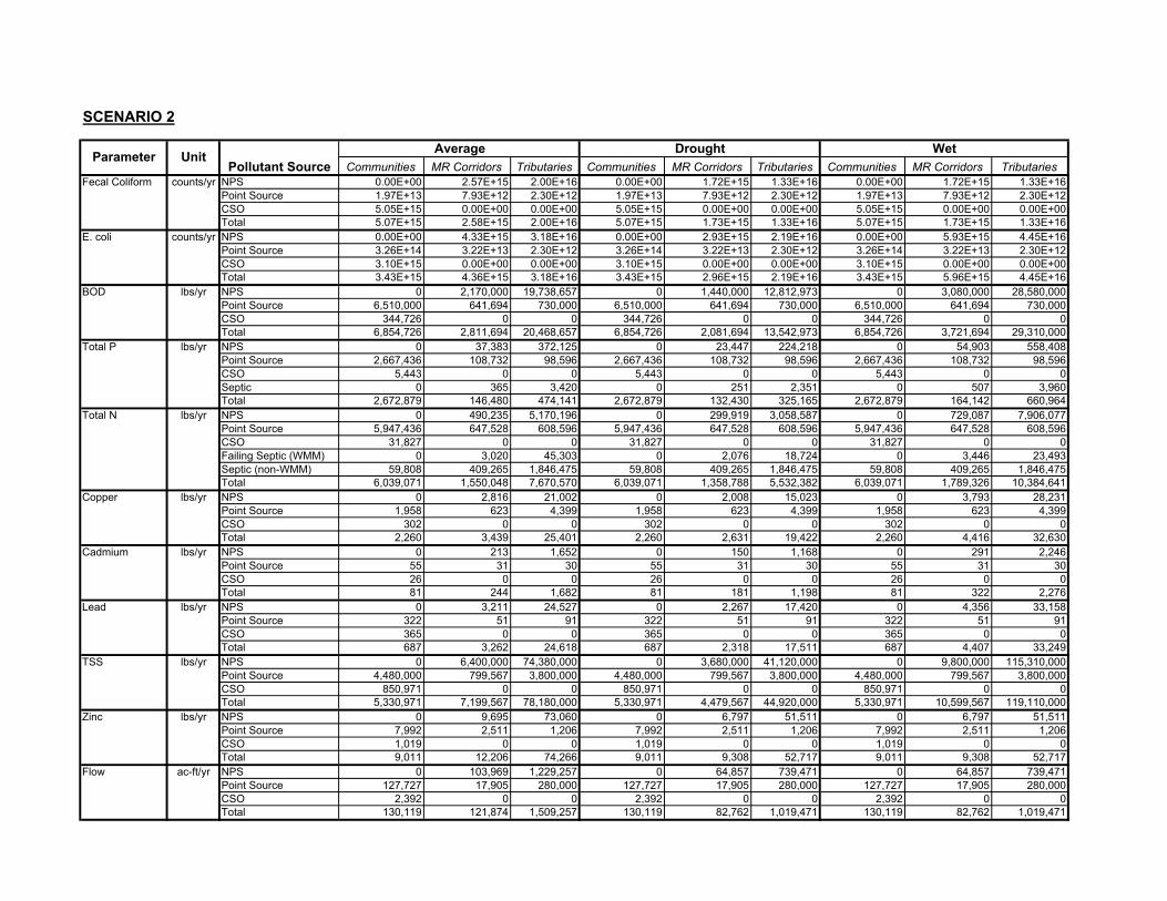
SCENARIO 2
Communities MR Corridors Tributaries Communities MR Corridors Tributaries Communities MR Corridors TributariesFecal Coliform counts/yr NPS 0.00E+00 2.57E+15 2.00E+16 0.00E+00 1.72E+15 1.33E+16 0.00E+00 1.72E+15 1.33E+16
Point Source 1.97E+13 7.93E+12 2.30E+12 1.97E+13 7.93E+12 2.30E+12 1.97E+13 7.93E+12 2.30E+12CSO 5.05E+15 0.00E+00 0.00E+00 5.05E+15 0.00E+00 0.00E+00 5.05E+15 0.00E+00 0.00E+00Total 5.07E+15 2.58E+15 2.00E+16 5.07E+15 1.73E+15 1.33E+16 5.07E+15 1.73E+15 1.33E+16
E. coli counts/yr NPS 0.00E+00 4.33E+15 3.18E+16 0.00E+00 2.93E+15 2.19E+16 0.00E+00 5.93E+15 4.45E+16Point Source 3.26E+14 3.22E+13 2.30E+12 3.26E+14 3.22E+13 2.30E+12 3.26E+14 3.22E+13 2.30E+12CSO 3.10E+15 0.00E+00 0.00E+00 3.10E+15 0.00E+00 0.00E+00 3.10E+15 0.00E+00 0.00E+00Total 3.43E+15 4.36E+15 3.18E+16 3.43E+15 2.96E+15 2.19E+16 3.43E+15 5.96E+15 4.45E+16
BOD lbs/yr NPS 0 2,170,000 19,738,657 0 1,440,000 12,812,973 0 3,080,000 28,580,000Point Source 6,510,000 641,694 730,000 6,510,000 641,694 730,000 6,510,000 641,694 730,000CSO 344,726 0 0 344,726 0 0 344,726 0 0Total 6,854,726 2,811,694 20,468,657 6,854,726 2,081,694 13,542,973 6,854,726 3,721,694 29,310,000
Total P lbs/yr NPS 0 37,383 372,125 0 23,447 224,218 0 54,903 558,408Point Source 2,667,436 108,732 98,596 2,667,436 108,732 98,596 2,667,436 108,732 98,596CSO 5,443 0 0 5,443 0 0 5,443 0 0Septic 0 365 3,420 0 251 2,351 0 507 3,960Total 2,672,879 146,480 474,141 2,672,879 132,430 325,165 2,672,879 164,142 660,964
Total N lbs/yr NPS 0 490,235 5,170,196 0 299,919 3,058,587 0 729,087 7,906,077Point Source 5,947,436 647,528 608,596 5,947,436 647,528 608,596 5,947,436 647,528 608,596CSO 31,827 0 0 31,827 0 0 31,827 0 0Failing Septic (WMM) 0 3,020 45,303 0 2,076 18,724 0 3,446 23,493Septic (non-WMM) 59,808 409,265 1,846,475 59,808 409,265 1,846,475 59,808 409,265 1,846,475Total 6,039,071 1,550,048 7,670,570 6,039,071 1,358,788 5,532,382 6,039,071 1,789,326 10,384,641
Copper lbs/yr NPS 0 2,816 21,002 0 2,008 15,023 0 3,793 28,231Point Source 1,958 623 4,399 1,958 623 4,399 1,958 623 4,399CSO 302 0 0 302 0 0 302 0 0Total 2,260 3,439 25,401 2,260 2,631 19,422 2,260 4,416 32,630
Cadmium lbs/yr NPS 0 213 1,652 0 150 1,168 0 291 2,246Point Source 55 31 30 55 31 30 55 31 30CSO 26 0 0 26 0 0 26 0 0Total 81 244 1,682 81 181 1,198 81 322 2,276
Lead lbs/yr NPS 0 3,211 24,527 0 2,267 17,420 0 4,356 33,158Point Source 322 51 91 322 51 91 322 51 91CSO 365 0 0 365 0 0 365 0 0Total 687 3,262 24,618 687 2,318 17,511 687 4,407 33,249
TSS lbs/yr NPS 0 6,400,000 74,380,000 0 3,680,000 41,120,000 0 9,800,000 115,310,000Point Source 4,480,000 799,567 3,800,000 4,480,000 799,567 3,800,000 4,480,000 799,567 3,800,000CSO 850,971 0 0 850,971 0 0 850,971 0 0Total 5,330,971 7,199,567 78,180,000 5,330,971 4,479,567 44,920,000 5,330,971 10,599,567 119,110,000
Zinc lbs/yr NPS 0 9,695 73,060 0 6,797 51,511 0 6,797 51,511Point Source 7,992 2,511 1,206 7,992 2,511 1,206 7,992 2,511 1,206CSO 1,019 0 0 1,019 0 0 1,019 0 0Total 9,011 12,206 74,266 9,011 9,308 52,717 9,011 9,308 52,717
Flow ac-ft/yr NPS 0 103,969 1,229,257 0 64,857 739,471 0 64,857 739,471Point Source 127,727 17,905 280,000 127,727 17,905 280,000 127,727 17,905 280,000CSO 2,392 0 0 2,392 0 0 2,392 0 0Total 130,119 121,874 1,509,257 130,119 82,762 1,019,471 130,119 82,762 1,019,471
WetUnitParameterPollutant Source
Average Drought
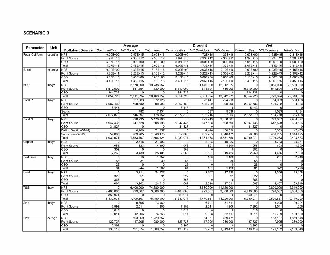
SCENARIO 3
Communities MR Corridors Tributaries Communities MR Corridors Tributaries Communities MR Corridors TributariesFecal Coliform count/yr NPS 0.00E+00 2.57E+15 2.00E+16 0.00E+00 1.72E+15 1.33E+16 0.00E+00 3.63E+15 2.81E+16
Point Source 1.97E+13 7.93E+12 2.30E+12 1.97E+13 7.93E+12 2.30E+12 1.97E+13 7.93E+12 2.30E+12CSO 5.05E+15 0.00E+00 0.00E+00 5.05E+15 0.00E+00 0.00E+00 5.05E+15 0.00E+00 0.00E+00Total 5.07E+15 2.58E+15 2.00E+16 5.07E+15 1.73E+15 1.33E+16 5.07E+15 3.64E+15 2.81E+16
E. coli count/yr NPS 0.00E+00 4.33E+15 3.18E+16 0.00E+00 2.93E+15 2.19E+16 0.00E+00 5.93E+15 4.45E+16Point Source 3.26E+14 3.22E+13 2.30E+12 3.26E+14 3.22E+13 2.30E+12 3.26E+14 3.22E+13 2.30E+12CSO 3.10E+15 0.00E+00 0.00E+00 3.10E+15 0.00E+00 0.00E+00 3.10E+15 0.00E+00 0.00E+00Total 3.43E+15 4.36E+15 3.18E+16 3.43E+15 2.96E+15 2.19E+16 3.43E+15 5.96E+15 4.45E+16
BOD lbs/yr NPS 0 2,170,000 19,738,657 0 1,440,000 12,812,973 0 3,080,000 28,580,000Point Source 6,510,000 641,694 730,000 6,510,000 641,694 730,000 6,510,000 641,694 730,000CSO 344,726 0 0 344,726 0 0 344,726 0 0Total 6,854,726 2,811,694 20,468,657 6,854,726 2,081,694 13,542,973 6,854,726 3,721,694 29,310,000
Total P lbs/yr NPS 0 37,383 372,125 0 23,447 224,218 0 54,903 558,408Point Source 2,667,436 108,732 98,596 2,667,436 108,732 98,596 2,667,436 108,732 98,596CSO 5,443 0 0 5,443 0 0 5,443 0 0Septic 0 782 7,331 0 537 5,038 0 1,083 8,484Total 2,672,879 146,897 478,052 2,672,879 132,716 327,852 2,672,879 164,718 665,488
Total N lbs/yr NPS 0 490,235 5,170,196 0 299,919 3,058,587 0 729,087 7,906,077Point Source 5,947,436 647,528 608,596 5,947,436 647,528 608,596 5,947,436 647,528 608,596CSO 31,827 0 0 31,827 0 0 31,827 0 0Failing Septic (WMM) 0 6,469 71,357 0 4,446 38,098 0 7,383 47,485Septic (non-WMM) 59,808 409,265 1,846,475 59,808 409,265 1,846,475 59,808 409,265 1,846,475Total 6,039,071 1,553,497 7,696,624 6,039,071 1,361,158 5,551,756 6,039,071 1,793,263 10,408,633
Copper lbs/yr NPS 0 2,816 21,002 0 2,008 15,023 0 3,793 28,231Point Source 1,958 623 4,399 1,958 623 4,399 1,958 623 4,399CSO 302 0 0 302 0 0 302 0 0Total 2,260 3,439 25,401 2,260 2,631 19,422 2,260 4,416 32,630
Cadmium lbs/yr NPS 0 213 1,652 0 150 1,168 0 291 2,246Point Source 55 31 30 55 31 30 55 31 30CSO 26 0 0 26 0 0 26 0 0Total 81 244 1,682 81 181 1,198 81 322 2,276
Lead lbs/yr NPS 0 3,211 24,527 0 2,267 17,420 0 4,356 33,158Point Source 322 51 91 322 51 91 322 51 91CSO 365 0 0 365 0 0 365 0 0Total 687 3,262 24,618 687 2,318 17,511 687 4,407 33,249
TSS lbs/yr NPS 0 6,400,000 74,380,000 0 3,680,000 41,120,000 0 9,800,000 115,310,000Point Source 4,480,000 799,567 3,800,000 4,480,000 799,567 3,800,000 4,480,000 799,567 3,800,000CSO 850,971 0 0 850,971 0 0 850,971 0 0Total 5,330,971 7,199,567 78,180,000 5,330,971 4,479,567 44,920,000 5,330,971 10,599,567 119,110,000
Zinc lbs/yr NPS 0 9,695 73,060 0 6,797 51,511 0 13,228 99,294Point Source 7,992 2,511 1,206 7,992 2,511 1,206 7,992 2,511 1,206CSO 1,019 0 0 1,019 0 0 1,019 0 0Total 9,011 12,206 74,266 9,011 9,308 52,717 9,011 15,739 100,500
Flow ac-ft/yr NPS 0 103,969 1,229,257 0 64,857 739,471 0 153,197 1,859,548Point Source 127,727 17,905 280,000 127,727 17,905 280,000 127,727 17,905 280,000CSO 2,392 0 0 2,392 0 0 2,392 0 0Total 130,119 121,874 1,509,257 130,119 82,762 1,019,471 130,119 171,102 2,139,548
WetPollutant Source
Parameter Unit Average Drought

SCENARIO 4
Communities MR Corridors Tributaries Communities MR Corridors Tributaries Communities MR Corridors TributariesFecal Coliform counts/yr NPS 0.00E+00 2.57E+15 2.00E+16 0.00E+00 1.72E+15 1.33E+16 0.00E+00 3.63E+15 2.81E+16
Point Source 1.97E+13 7.93E+12 2.30E+12 1.97E+13 7.93E+12 2.30E+12 1.97E+13 7.93E+12 2.30E+12CSO 5.05E+15 0.00E+00 0.00E+00 5.05E+15 0.00E+00 0.00E+00 5.05E+15 0.00E+00 0.00E+00Total 5.07E+15 2.58E+15 2.00E+16 5.07E+15 1.73E+15 1.33E+16 5.07E+15 3.64E+15 2.81E+16
E. coli counts/yr NPS 0.00E+00 4.33E+15 3.18E+16 0.00E+00 2.93E+15 2.19E+16 0.00E+00 5.93E+15 4.45E+16Point Source 3.26E+14 3.22E+13 2.30E+12 3.26E+14 3.22E+13 2.30E+12 3.26E+14 3.22E+13 2.30E+12CSO 3.10E+15 0.00E+00 0.00E+00 3.10E+15 0.00E+00 0.00E+00 3.10E+15 0.00E+00 0.00E+00Total 3.43E+15 4.36E+15 3.18E+16 3.43E+15 2.96E+15 2.19E+16 3.43E+15 5.96E+15 4.45E+16
BOD lbs/yr NPS 0 2,170,000 19,738,657 0 1,440,000 12,812,973 0 3,080,000 28,580,000Point Source 6,510,000 641,694 730,000 6,510,000 641,694 730,000 6,510,000 641,694 730,000CSO 344,726 0 0 344,726 0 0 344,726 0 0Total 6,854,726 2,811,694 20,468,657 6,854,726 2,081,694 13,542,973 6,854,726 3,721,694 29,310,000
Total P lbs/yr NPS 0 37,383 372,125 0 23,447 224,218 0 54,903 558,408Point Source 2,667,436 108,732 98,596 2,667,436 108,732 98,596 2,667,436 108,732 98,596CSO 5,443 0 0 5,443 0 0 5,443 0 0Septic 0 156 1,465 0 108 1,008 0 216 1,697Total 2,672,879 146,271 472,186 2,672,879 132,287 323,822 2,672,879 163,851 658,701
Total N lbs/yr NPS 0 490,235 5,170,196 0 299,919 3,058,587 0 729,087 7,906,077Point Source 5,947,436 647,528 608,596 7,627,436 647,528 608,596 7,627,436 647,528 608,596CSO 31,827 0 0 35,123 0 0 35,123 0 0Failing Septic (WMM) 0 1,294 2,272 0 889 13,737 0 1,477 11,497Septic (non-WMM) 59,808 409,265 1,846,475 59,808 409,265 1,846,475 59,808 409,265 1,846,475Total 6,039,071 1,548,322 7,627,539 7,722,367 1,357,601 5,527,395 7,722,367 1,787,357 10,372,645
Copper lbs/yr NPS 0 2,816 21,002 0 2,008 15,023 0 3,793 28,231Point Source 1,958 623 4,399 1,958 623 4,399 1,958 623 4,399CSO 302 0 0 302 0 0 302 0 0Total 2,260 3,439 25,401 2,260 2,631 19,422 2,260 4,416 32,630
Cadmium lbs/yr NPS 0 213 1,652 0 150 1,168 0 291 2,246Point Source 55 31 30 55 31 30 55 31 30CSO 26 0 0 26 0 0 26 0 0Total 81 244 1,682 81 181 1,198 81 322 2,276
Lead lbs/yr NPS 0 3,211 24,527 0 2,267 17,420 0 4,356 33,158Point Source 322 51 91 322 51 91 322 51 91CSO 365 0 0 365 0 0 365 0 0Total 687 3,262 24,618 687 2,318 17,511 687 4,407 33,249
TSS lbs/yr NPS 0 6,400,000 74,380,000 0 3,680,000 41,120,000 0 9,800,000 115,310,000Point Source 4,480,000 799,567 3,800,000 4,480,000 799,567 3,800,000 4,480,000 799,567 3,800,000CSO 850,971 0 0 850,971 0 0 850,971 0 0Total 5,330,971 7,199,567 78,180,000 5,330,971 4,479,567 44,920,000 5,330,971 10,599,567 119,110,000
Zinc lbs/yr NPS 0 9,695 73,060 0 6,797 51,511 0 13,228 99,294Point Source 7,992 2,511 1,206 7,992 2,511 1,206 7,992 2,511 1,206CSO 1,019 0 0 1,019 0 0 1,019 0 0Total 9,011 12,206 74,266 9,011 9,308 52,717 9,011 15,739 100,500
Flow ac-ft/yr NPS 0 103,969 1,229,257 0 64,857 739,471 0 153,197 1,859,548Point Source 127,727 17,905 280,000 127,727 17,905 280,000 127,727 17,905 280,000CSO 2,392 0 0 2,392 0 0 2,392 0 0Total 130,119 121,874 1,509,257 130,119 82,762 1,019,471 130,119 171,102 2,139,548
WetUnitParameterPollutant Source
Average Drought

SCENARIO 5
Communities MR Corridors Tributaries Communities MR Corridors Tributaries Communities MR Corridors TributariesFecal Coliform counts/yr NPS 0.00E+00 4.31E+15 3.30E+16 0.00E+00 2.90E+15 2.22E+16 0.00E+00 5.96E+15 4.69E+16
Point Source 1.97E+13 7.93E+12 2.30E+12 1.97E+13 7.93E+12 2.30E+12 1.97E+13 7.93E+12 2.30E+12CSO 5.05E+15 0.00E+00 0.00E+00 5.05E+15 0.00E+00 0.00E+00 5.05E+15 0.00E+00 0.00E+00Total 5.07E+15 4.32E+15 3.30E+16 5.07E+15 2.91E+15 2.22E+16 5.07E+15 5.97E+15 4.69E+16
E. coli counts/yr NPS 0.00E+00 7.15E+15 5.33E+16 0.00E+00 4.86E+15 3.60E+16 0.00E+00 9.99E+15 7.43E+16Point Source 3.26E+14 3.22E+13 2.30E+12 3.26E+14 3.22E+13 2.30E+12 3.26E+14 3.22E+13 2.30E+12CSO 3.10E+15 0.00E+00 0.00E+00 3.10E+15 0.00E+00 0.00E+00 3.10E+15 0.00E+00 0.00E+00Total 3.43E+15 7.18E+15 5.33E+16 3.43E+15 4.89E+15 3.60E+16 3.43E+15 1.00E+16 7.43E+16
BOD lbs/yr NPS 0 2,170,000 19,738,657 0 1,440,000 12,812,973 0 3,080,000 28,580,000Point Source 6,510,000 641,694 730,000 6,510,000 641,694 730,000 6,510,000 641,694 730,000CSO 344,726 0 0 344,726 0 0 344,726 0 0Total 6,854,726 2,811,694 20,468,657 6,854,726 2,081,694 13,542,973 6,854,726 3,721,694 29,310,000
Total P lbs/yr NPS 0 50,451 496,482 0 31,741 304,083 0 73,962 754,436Point Source 2,667,436 108,732 98,596 2,667,436 108,732 98,596 2,667,436 108,732 98,596CSO 5,443 0 0 5,443 0 0 5,443 0 0Septic 0 457 3,576 0 315 2,938 0 633 4,477Total 2,672,879 159,640 598,654 2,672,879 140,788 405,617 2,672,879 183,327 857,509
Total N lbs/yr NPS 0 638,444 6,773,460 0 394,258 4,058,977 0 944,727 10,316,547Point Source 5,947,436 647,528 608,596 5,947,436 647,528 608,596 5,947,436 647,528 608,596CSO 31,827 0 0 31,827 0 0 31,827 0 0Failing Septic (WMM) 0 3,545 66,123 0 2,436 28,943 0 2,736 63,605Septic (non-WMM) 59,808 409,265 1,846,475 59,808 409,265 1,846,475 59,808 409,265 1,846,475Total 6,039,071 1,698,782 9,294,654 6,039,071 1,453,487 6,542,991 6,039,071 2,004,256 12,835,223
Copper lbs/yr NPS 0 4,167 31,569 0 2,978 22,641 0 5,608 42,359Point Source 1,958 623 4,399 1,958 623 4,399 1,958 623 4,399CSO 302 0 0 302 0 0 302 0 0Total 2,260 4,790 35,968 2,260 3,601 27,040 2,260 6,231 46,758
Cadmium lbs/yr NPS 0 343 2,714 0 242 1,927 0 467 3,670Point Source 55 31 30 55 31 30 55 31 30CSO 26 0 0 26 0 0 26 0 0Total 81 374 2,744 81 273 1,957 81 498 3,700
Lead lbs/yr NPS 0 5,877 45,181 0 4,162 32,160 0 7,962 60,981Point Source 322 51 91 322 51 91 322 51 91CSO 365 0 0 365 0 0 365 0 0Total 687 5,928 45,272 687 4,213 32,251 687 8,013 61,072
TSS lbs/yr NPS 0 12,800,000 146,860,000 0 7,250,000 81,300,000 0 19,800,000 230,600,000Point Source 4,480,000 799,567 3,800,000 4,480,000 799,567 3,800,000 4,480,000 799,567 3,800,000CSO 850,971 0 0 850,971 0 0 850,971 0 0Total 5,330,971 13,599,567 150,660,000 5,330,971 8,049,567 85,100,000 5,330,971 20,599,567 234,400,000
Zinc lbs/yr NPS 0 12,908 99,977 0 9,096 70,935 0 17,548 135,253Point Source 7,992 2,511 1,206 7,992 2,511 1,206 7,992 2,511 1,206CSO 1,019 0 0 1,019 0 0 1,019 0 0Total 9,011 15,419 101,183 9,011 11,607 72,141 9,011 20,059 136,459
Flow ac-ft/yr NPS 0 103,969 1,229,257 0 64,857 739,471 0 153,197 1,859,548Point Source 127,727 17,905 280,000 127,727 17,905 280,000 127,727 17,905 280,000CSO 2,392 0 0 2,392 0 0 2,392 0 0Total 130,119 121,874 1,509,257 130,119 82,762 1,019,471 130,119 171,102 2,139,548
Average Drought WetParameterPollutant Source
Unit
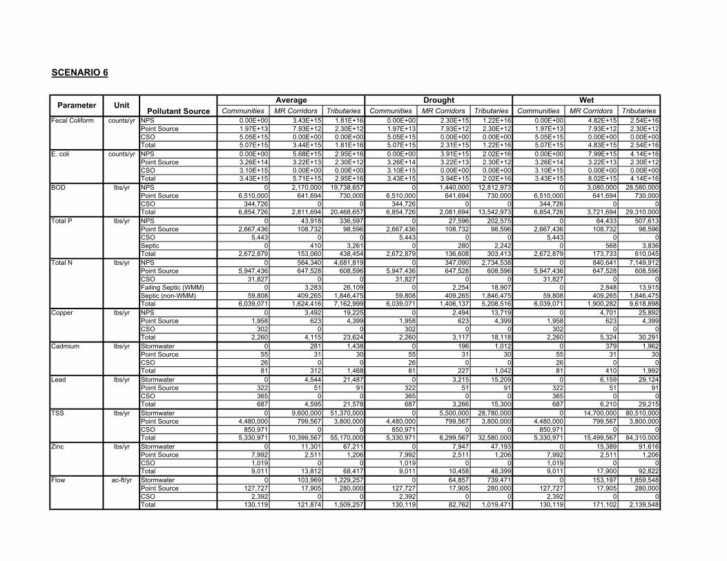
SCENARIO 6
Communities MR Corridors Tributaries Communities MR Corridors Tributaries Communities MR Corridors TributariesFecal Coliform counts/yr NPS 0.00E+00 3.43E+15 1.81E+16 0.00E+00 2.30E+15 1.22E+16 0.00E+00 4.82E+15 2.54E+16
Point Source 1.97E+13 7.93E+12 2.30E+12 1.97E+13 7.93E+12 2.30E+12 1.97E+13 7.93E+12 2.30E+12CSO 5.05E+15 0.00E+00 0.00E+00 5.05E+15 0.00E+00 0.00E+00 5.05E+15 0.00E+00 0.00E+00Total 5.07E+15 3.44E+15 1.81E+16 5.07E+15 2.31E+15 1.22E+16 5.07E+15 4.83E+15 2.54E+16
E. coli counts/yr NPS 0.00E+00 5.68E+15 2.95E+16 0.00E+00 3.91E+15 2.02E+16 0.00E+00 7.99E+15 4.14E+16Point Source 3.26E+14 3.22E+13 2.30E+12 3.26E+14 3.22E+13 2.30E+12 3.26E+14 3.22E+13 2.30E+12CSO 3.10E+15 0.00E+00 0.00E+00 3.10E+15 0.00E+00 0.00E+00 3.10E+15 0.00E+00 0.00E+00Total 3.43E+15 5.71E+15 2.95E+16 3.43E+15 3.94E+15 2.02E+16 3.43E+15 8.02E+15 4.14E+16
BOD lbs/yr NPS 0 2,170,000 19,738,657 0 1,440,000 12,812,973 0 3,080,000 28,580,000Point Source 6,510,000 641,694 730,000 6,510,000 641,694 730,000 6,510,000 641,694 730,000CSO 344,726 0 0 344,726 0 0 344,726 0 0Total 6,854,726 2,811,694 20,468,657 6,854,726 2,081,694 13,542,973 6,854,726 3,721,694 29,310,000
Total P lbs/yr NPS 0 43,918 336,597 0 27,596 202,575 0 64,433 507,613Point Source 2,667,436 108,732 98,596 2,667,436 108,732 98,596 2,667,436 108,732 98,596CSO 5,443 0 0 5,443 0 0 5,443 0 0Septic 0 410 3,261 0 280 2,242 0 568 3,836Total 2,672,879 153,060 438,454 2,672,879 136,608 303,413 2,672,879 173,733 610,045
Total N lbs/yr NPS 0 564,340 4,681,819 0 347,090 2,734,538 0 840,641 7,149,912Point Source 5,947,436 647,528 608,596 5,947,436 647,528 608,596 5,947,436 647,528 608,596CSO 31,827 0 0 31,827 0 0 31,827 0 0Failing Septic (WMM) 0 3,283 26,109 0 2,254 18,907 0 2,848 13,915Septic (non-WMM) 59,808 409,265 1,846,475 59,808 409,265 1,846,475 59,808 409,265 1,846,475Total 6,039,071 1,624,416 7,162,999 6,039,071 1,406,137 5,208,516 6,039,071 1,900,282 9,618,898
Copper lbs/yr NPS 0 3,492 19,225 0 2,494 13,719 0 4,701 25,892Point Source 1,958 623 4,399 1,958 623 4,399 1,958 623 4,399CSO 302 0 0 302 0 0 302 0 0Total 2,260 4,115 23,624 2,260 3,117 18,118 2,260 5,324 30,291
Cadmium lbs/yr Stormwater 0 281 1,438 0 196 1,012 0 379 1,962Point Source 55 31 30 55 31 30 55 31 30CSO 26 0 0 26 0 0 26 0 0Total 81 312 1,468 81 227 1,042 81 410 1,992
Lead lbs/yr Stormwater 0 4,544 21,487 0 3,215 15,209 0 6,159 29,124Point Source 322 51 91 322 51 91 322 51 91CSO 365 0 0 365 0 0 365 0 0Total 687 4,595 21,578 687 3,266 15,300 687 6,210 29,215
TSS lbs/yr Stormwater 0 9,600,000 51,370,000 0 5,500,000 28,780,000 0 14,700,000 80,510,000Point Source 4,480,000 799,567 3,800,000 4,480,000 799,567 3,800,000 4,480,000 799,567 3,800,000CSO 850,971 0 0 850,971 0 0 850,971 0 0Total 5,330,971 10,399,567 55,170,000 5,330,971 6,299,567 32,580,000 5,330,971 15,499,567 84,310,000
Zinc lbs/yr Stormwater 0 11,301 67,211 0 7,947 47,193 0 15,389 91,616Point Source 7,992 2,511 1,206 7,992 2,511 1,206 7,992 2,511 1,206CSO 1,019 0 0 1,019 0 0 1,019 0 0Total 9,011 13,812 68,417 9,011 10,458 48,399 9,011 17,900 92,822
Flow ac-ft/yr Stormwater 0 103,969 1,229,257 0 64,857 739,471 0 153,197 1,859,548Point Source 127,727 17,905 280,000 127,727 17,905 280,000 127,727 17,905 280,000CSO 2,392 0 0 2,392 0 0 2,392 0 0Total 130,119 121,874 1,509,257 130,119 82,762 1,019,471 130,119 171,102 2,139,548
Drought WetParameterPollutant Source
Unit Average