Embed Size (px)
Citation preview

M.E.S TEACHERS COLLEGE C.T.E., BANGALORE RURAL RAJAJINAGAR, BANGALURU – 10
Online Assignment On
Natural Disasters & their Rehabilitation Programmes
Submitted as per the requirement for the Second Semester B.Ed of Bangalore University 2014-15.
Presented byJayashree. P 14EDD13022

2004 Indian Ocean Earthquake and Tsunami
The 2004 Indian Ocean earthquake occurred at 00:58:53 UTC on 26 December with an epicentre off the west coast of Sumatra, Indonesia. The event is known by the scientific community as the Sumatra–Andaman earthquake. The resulting tsunami was given various names, including the 2004 Indian Ocean tsunami, South Asian tsunami, Indonesian tsunami, the Christmastsunami and the Boxing Day tsunami.The undersea megathrust earthquake was caused when the Indian Plate was subducted by the Burma Plate and triggered a series of devastating tsunamis along the coasts of most landmasses bordering the Indian Ocean, killing 230,000 people in 14 countries, and inundating coastal communities with waves up to 30 metre (100 ft) high. It was one of the deadliest natural disasters in recorded history. Indonesia was the hardesthit country, followed by Sri Lanka, India, and Thailand. With a magnitude of Mw 9.1–9.3, it is the thirdlargest earthquake ever recorded on a seismograph. The earthquake had the longest duration of faulting ever observed, between 8.3 and 10 minutes. It caused the entire planet to vibrate as much as 1 centimetre (0.4 inches) and triggered other earthquakes as far away as Alaska. Its epicentre was between Simeulue and mainland Indonesia. The plight of the affected people and countries prompted a worldwide humanitarian response. In all, the worldwide community donated more than US$14 billion (2004) in humanitarian aid.

Earthquake Characteristics
The earthquake was initially documented as moment magnitude 8.8. In February 2005 scientists revised the estimate of the magnitude to 9.0. Although the Pacific Tsunami Warning Center has accepted these new numbers, the United States Geological Survey has so far not changed its estimate of 9.1. The most recent studies in 2006 have obtained a magnitude of Mw 9.1–9.3. Dr. Hiroo Kanamori of the California Institute of Technology believes that Mw 9.2 is a good representative value for the size of this great earthquake. The hypocentre of the main earthquake was approximately 160 km (100 mi) off the western coast of northern Sumatra, in the Indian Ocean just north of Simeulue island at a depth of 30 km (19 mi) below mean sea level (initially reported as 10 km (6.2 mi)). The northern section of the Sunda megathrust ruptured over a length of 1,300 km (810 mi).[12] The earthquake (followed by the tsunami) was felt simultaneously in Bangladesh, India, Malaysia, Myanmar, Thailand, Singapore and the Maldives. Splay faults, or secondary "pop up faults", caused long, narrow parts of the sea floor to pop up in seconds. This quickly elevated the height and increased the speed of waves, causing the complete destruction of the nearby Indonesian town of Lhoknga.Since 1900 the only earthquakes recorded with a greater magnitude were the 1960 Great Chilean earthquake (magnitude 9.5) and the 1964 Good Friday earthquake in Prince William Sound (9.2). The only other recorded earthquakes of magnitude 9.0 or greater were off Kamchatka, Russia, on 4 November 1952 (magnitude 9.0)[18] and Tōhoku, Japan (magnitude 9.0) in March 2011.
ForeshockThe 2002 Sumatra earthquake is believed to have been a foreshock, predating the main event by over two years.

Tsunami
The sudden vertical rise of the seabed by several metres during the earthquake displaced massive volumes of water, resulting in a tsunami that struck the coasts of the Indian Ocean. A tsunami that causes damage far away from its source is sometimes called a teletsunami and is much more likely to be produced by vertical motion of the seabed than by horizontal motion.

The tsunami, like all others, behaved very differently in deep water than in shallow water. In deep ocean water, tsunami waves form only a small hump, barely noticeable and harmless, which generally travels at a very high speed of 500 to 1,000 km/h (310 to 620 mph); in shallow water near coastlines, a tsunami slows down to only tens of kilometres per hour but, in doing so, forms large destructivewaves. Scientists investigating the damage in Aceh found evidence that the wave reached a height of 24 metres (80 ft) when coming ashore along large stretches of the coastline, rising to 30 metres (100 ft) in some areas when traveling inland.Radar satellites recorded the heights of tsunami waves in deep water: at two hours after the earthquake, the maximum height was 60 centimetres (2 ft). These are the first such observations ever made. Unfortunately these observations could not be used to provide a warning, since the satellites were not built for that purpose and the data took hours to analyze. According to Tad Murty, vicepresident of the Tsunami Society, the total energy of the tsunami waves was equivalent to about five megatons of TNT (20 petajoules). This is more than twice the total explosive energy used during all of World War II (including the two atomic bombs) but still a couple of orders of magnitude less than the energy released in the earthquake itself. In many places the waves reached as far as 2 km (1.2 mi) inland. Because the 1,600 km (1,000 mi) fault affected by the earthquake was in a nearly northsouth orientation, the greatest strength of the tsunami waves was in an eastwest direction. Bangladesh, which lies at the northern end of the Bay of Bengal, had very few casualties despite being a lowlying country relatively near the epicenter. It also benefited from the fact that the earthquake proceeded more slowly in the northern rupture zone, greatly reducing the energy of the water displacements in that region.Coasts that have a landmass between them and the tsunami's location of origin are usually safe; however, tsunami waves can sometimes diffract around such landmasses. Thus, the state of Kerala was hit by the tsunami despite being on the

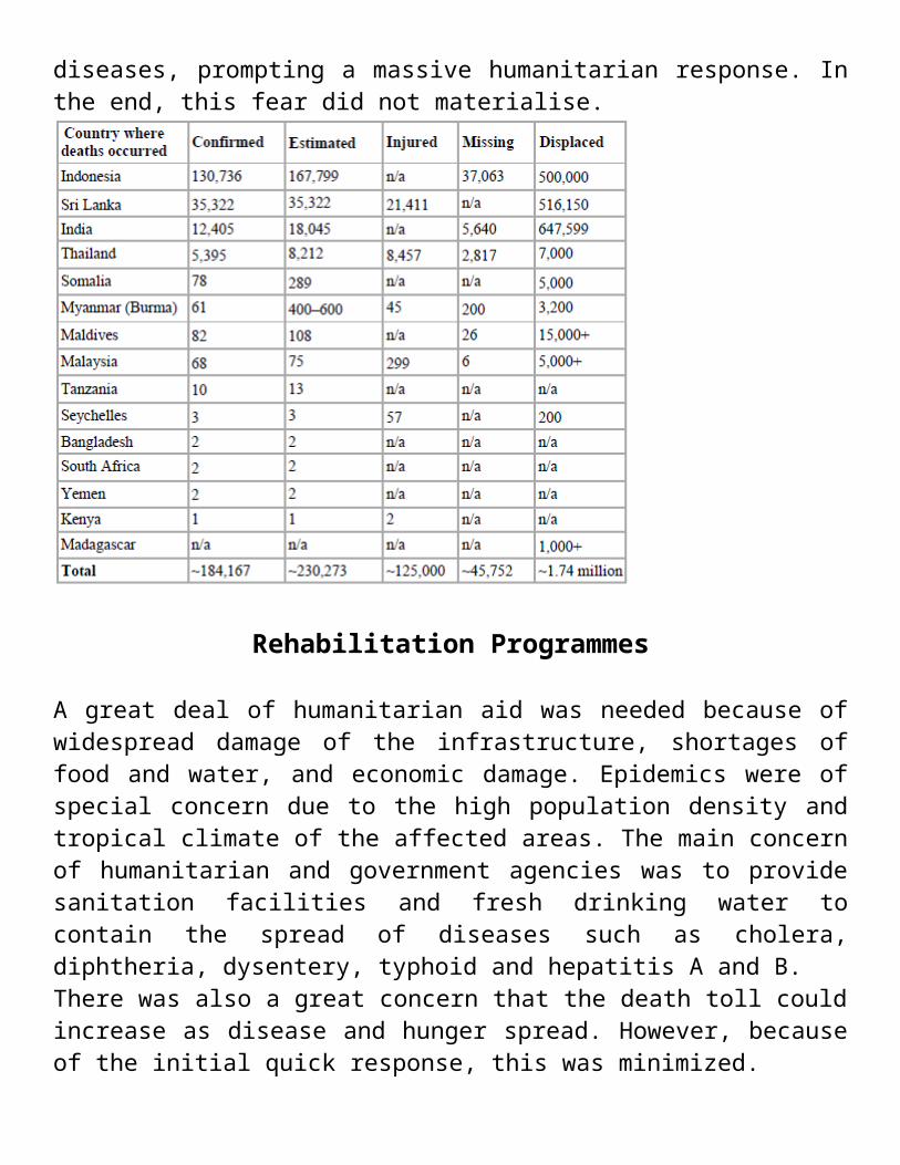
western coast of India, and the western coast of Sri Lanka suffered substantial impacts. Distance alone was no guarantee of safety, as Somalia was hit harder than Bangladesh despite being much farther away.Because of the distances involved, the tsunami took anywhere from fifteen minutes to seven hours to reach the coastlines. The northern regions of the Indonesian island of Sumatra were hit very quickly, while Sri Lanka and the east coast of India were hit roughly 90 minutes to two hours later. Thailand was struck about two hours later despite being closer to the epicentre, because the tsunami traveled more slowly in the shallow Andaman Sea off its western coast. way from the epicentre. In total, eight people in South Africa died due to abnormally high sea levels and waves.Relief agencies reported that onethird of the dead appeared to be children. This was a result of the high proportion of children in the populations of many of the affected regions and because children were the least able to resist being overcome by the surging waters. Oxfam went on to report that as many as four times more women than men were killed in some regions because they were waiting on the beach for the fishermen to return and looking after their children in the houses.In addition to the large number of local residents, up to 9,000 foreign tourists (mostly Europeans) enjoying the peak holiday travel season were among the dead or missing, especially people from the Nordic countries. The European nation hardest hit may have been Sweden, whose death toll was 543.States of emergency were declared in Sri Lanka, Indonesia, and the Maldives. The United Nations estimated at the outset that the relief operation would be the costliest in human history. Then UN SecretaryGeneral Kofi Annan stated that reconstruction would probably take between five and ten years. Governments and nongovernmental organisations feared that the final death toll might double as a result of diseases, prompting a massive humanitarian response. In the end, this fear did not materialise.

Rehabilitation Programmes
A great deal of humanitarian aid was needed because of widespread damage of the infrastructure, shortages of food and water, and economic damage. Epidemics were of special concern due to the high population density and tropical climate of the affected areas. The main concern of humanitarian and government agencies was to provide sanitation facilities and fresh drinking water to contain the spread of diseases such as cholera, diphtheria, dysentery, typhoid and hepatitis A and B.There was also a great concern that the death toll could increase as disease and hunger spread. However, because of the initial quick response, this was minimized.In the days following the tsunami, significant effort was spent in burying bodies hurriedly due to fear of disease spreading. However, the public health risks may have been exaggerated, and therefore this may not have been the best way to allocate resources. The World Food Programme provided food aid to more than 1.3 million people affected by the tsunami. Nations all over the world provided over US$14 billion in aid for damaged regions, with the governments of Australia pledging US$819.9 million (including a US$760.6million aid package for Indonesia), Germany offering US$660 million, Japan offering US$500 million, Canada offering US$343 million.
Norway and the Netherlands offering both US$183 million, the United States offering US$35 million initially (increased to US$350 million), and the World Bank offering US$250 million. Also Italy offered US$95 million, increased later to US$113 million of which US$42 million was donated by the population using the SMS system According to USAID, the US has pledged additional funds in longtermU.S. support to help the tsunami victims rebuild their lives. On 9 February2005, President Bush asked Congress to increase the U.S. commitment to a total of US$950 million. Officials estimated that billions of dollars would be needed. Bush also asked his father, former President George H. W. Bush, and former President Bill Clinton to lead a U.S. effort to provide private aid to the tsunami victims.In midMarch the Asian Development Bank reported that over US$4 billion in aid promised by governments was behind schedule. Sri Lanka reported that it had received no foreign government aid, while foreign individuals had been generous. Many charities were given considerable donations from the public. For example, in the United Kingdom the public donated roughly £330,000,000 sterling (nearlyUS$600,000,000). This considerably outweighed the donation by the government and came to an average of about £5.50 (US$10) donated by every citizen.In August 2006, fifteen local aid staff working on post tsunami rebuilding were found executed in northeast Sri Lanka after heavy fighting, the main umbrella body for aid agencies in the country said. There had been reports and rumors that the local aid workers had been killed.
References
Lay, T., Kanamori, H., Ammon, C., Nettles, M., Ward, S., Aster, R., Beck, S., Bilek, S., Brudzinski, M., Butler, R., DeShon, H., Ekström, G., Satake, K., Sipkin, S., The Great SumatraAndaman.
Earthquake of 26 December 2004, Science, 308, 1127–1133, doi:10.1126/science.1112250 (https://dx.doi.org/10.1126%2Fscience.1112250), 2005.
"Tsunamis and Earthquakes: Tsunami Generation from the 2004 Sumatra Earthquake — USGS Western Coastal and Marine Geology". Walrus.wr.usgs.gov. Retrieved 12 August 2010.