Embed Size (px)
Citation preview

Metasensing FastGBSAR Interferometro radar da terra in modalità SAR e RAR
Overview page 2
SAR Mode Land slope page 4 Mines Reservoir dam Land slide
RAR Mode Highway bridge page 6
Telecommunication tower Wind turbines Railway bridge
Ranger Software page 9
45° 27’ 39.384’’ N9° 07’ 30.145’’ E
CODEVINTECTecnologie per le Scienze della Terra e del Mare
FastGBSAR is a Ku-band ground-based interferometric radar system designed for > deformation monitoring > vibration measurement > stability assessment of natural slopes and man-made structures.

2
FastGBSAR Fast Ground-Based Synthetic Aperture Radar
MetaSensing has successfully deployed its innovative sensor to monitor > dams > bridges > landslides > open-pit mines > dikes (levees).
Features
> Dual-operation mode (SAR and RAR)
> Fast acquisition time tor high temperai resolution (scan time less than 5 s)
> Full polarimetry tor selection of responding scatterers
> System robustness for operations in harsh environmental conditions (high/low temperatures, inclement weather, dust, smoke, ashes etc.).
CODEVINTECTecnologie per le Scienze della Terra e del Mare
3
CODEVINTECTecnologie per le Scienze della Terra e del Mare
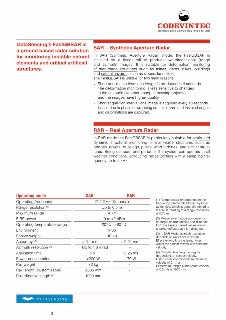
Operating mode SAR RAROperating frequency 17.2 GHz (Ku band)Range resolution (1) Up to 0.5 mMaximum range 4 kmEIRP power 19 to 42 dBmOperating temperature range -20º C to 60º CEnvironment IP65Sensor weight 10 kgAccuracy (2) ± 0.1 mm ± 0.01 mmAzimuth resolution (3) Up to 4.8 mrad -Aquisition time 5 s 0.25 msPower consumption <200 W 70 WRail weight 82 kg -Rail length (customizable) 2606 mm -Rail effective length (4) 1900 mm -
MetaSensing’s FastGBSAR is a ground based radar solution for monitoring instable natural elements and critical artificial structures.
SAR − Synthetic Aperture RadarIn SAR (Synthetic Aperture Radar) mode, the FastGBSAR is installed on a linear rail to produce two-dimensional (range and azimuth) images. It is suitable for deformation monitoring of man-made structures such as mines, dams, dikes, buildings and natural hazards, such as slopes, landslides.The FastGBSAR is unique for two main reasons:
> Short acquisition time: one image is produced in 4 seconds. The deformation monitoring is less sensitive to changes in the scenario (weather changes passing objects) and the images have higher quality.
> Short acquisition interval: one image is acquired every 10 seconds. Issues due to phase unwrapping are minimized and faster changes and deformations are captured.
RAR − Real Aperture RadarIn RAR mode the FastGBSAR is particularly suitable for static and dynamic structural monitoring of man-made structures such as bridges, towers, buildings, pillars, wind turbines, and similar struc-tures. Being compact and portable, the system can operate in all weather conditions, producing range profiles with a sampling fre-quency up to 4 kHz.
(1) Range resolution depends on the frequency bandwidth allowed by locai authorities, which is generally limited to 200 MHz, leading to a range resolution of 0.75 m.
(2) Measurement accuracy depends on target characteristics and distance from the sensor. Listed values are for a corner reflector at 1 km distance.
(3) In SAR Mode, azimuth resolution depends on rail effective length. Effective length is the length over which the sensor moves with constant velocity.
(4) Rail effective length is slightly dependent on sensor velocity. Listed value corresponds to minimum velocity of 0.1 m/s.Effective rail length at maximum velocity of 0.5 m/s is 1800 mm.

4
Monitoring an open-pit mine
FastGBSAR has been intensively monitoring an open-pit mine in Czech Republic to produce accurate dis-placement maps of the area.
The maximum distance was set to 1500 m, with a range resolution of 0.5 m and azimuth resolution of 5.4 mrad. The displacement is close to zero in almost all the area except in one part where a deformation of about 100 mm appears, this is due to the excavation works.
Figure shows the displacement map measured by the FastGBSAR around the open-pit mine and projected on a Digital Elevation Model.The movement of the excavator machine creates a movement away from the radar in the area behind it (red arrow) probably caused by the removal of mate-rial from the slope with relief of stress. A movements towards the radar (blue arrow) is also due to the ac-cumulation of material.
FastGBSAR – SAR mode
Monitoring a land slope
The FastGBSAR has been deployed on the side of a high-speed railway track in the Shanxi province in China, to monitor a land slope next to the railway. The measured displacement ranges from - 0.6 to 0.3 mm capturing the movement of the dry sand blown away from the wind caused by the passing train.The diagram reports the time series of the displace-ment for the three selected points.
Monitoring a land slope next to a high-speed railway track.
CODEVINTECTecnologie per le Scienze della Terra e del Mare

5
Monitoring a water reservoir dam
FastGBSAR has been deployed to monitor the response behavior of the Three Gorges test dam in China with respect to four different intensities of water discharge. The four steps of the water discharge are clearly visible from the red line corresponding to the gate of the dam.
Deployment site for the FastGBSAR, about 400 meters in front of the dam.
Time series of the displacement in four points of the dam before the water discharge (top) and during the water discharge (bottom).
Monitoring a land slide
FastGBSAR was deployed to observe a land slide in Italy to monitor slope stability and falling rocks.Figure shows the time series of the displacement for several points. The very high acquisitions rate (one image every 10 seconds) allowed a more efficient detection of falling rocks.The falling rock event can be seen as a abrupt and instantaneous change in the displacement series.
Monitoring the Corniolo (FC) land slide.
Time series of the displacement monitored for four different points.
CODEVINTECTecnologie per le Scienze della Terra e del Mare
6
FastGBSAR – RAR mode
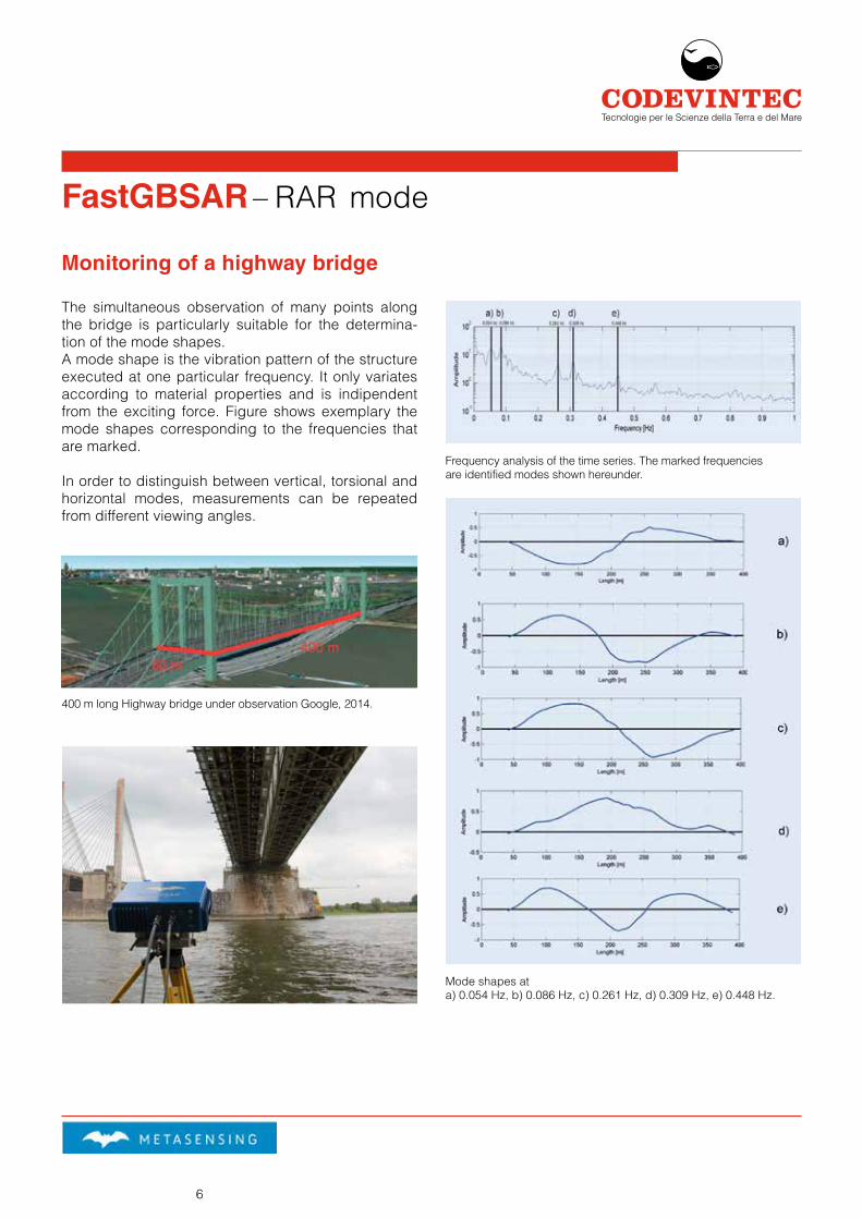
Monitoring of a highway bridge
The simultaneous observation of many points along the bridge is particularly suitable for the determina-tion of the mode shapes.A mode shape is the vibration pattern of the structure executed at one particular frequency. It only variates according to material properties and is indipendent from the exciting force. Figure shows exemplary the mode shapes corresponding to the frequencies that are marked.
In order to distinguish between vertical, torsional and horizontal modes, measurements can be repeated from different viewing angles.
400 m long Highway bridge under observation Google, 2014.
Frequency analysis of the time series. The marked frequencies are identified modes shown hereunder.
Mode shapes at a) 0.054 Hz, b) 0.086 Hz, c) 0.261 Hz, d) 0.309 Hz, e) 0.448 Hz.
CODEVINTECTecnologie per le Scienze della Terra e del Mare

7
Monitoring of telecommunication tower
A 42 meter high telecommunication tower has been monitored in moderate-low wind conditions. The measurements were per-formed by the polarimet-ric FastGBSAR version, equipped with four anten-nas. The use of the four polarimetric channels gives sensitivity to differ-ent scattering mechanism.
Figure shows the oscilla-tion of the tower plotted at three different heights for an osservation time of 10 seconds. The sub-millime-ter horizontal displacement value of the tower depends on the considered height.
Monitoring of wind turbines
The determination of vibrations and modal parameters of wind turbines can assist in the optimization of their design and performance.To avoid structural fail-ure, the knowledge of the eigenfrequencies of the tower and rotor blades is essential. In the following an example is shown of the smultaneous monitoring of two wind turbines at differ-ent distance.
Backscattered power and Signal to Noise Ratio (SNR) along the wind turbine. In corrispondence of the rotor, the SNR is low due to the moving rotor blades.
FastGBSAR installation for monitoring wind turbines.
Time series of horizontal displacement at different tower heights within the tower
CODEVINTECTecnologie per le Scienze della Terra e del Mare
8
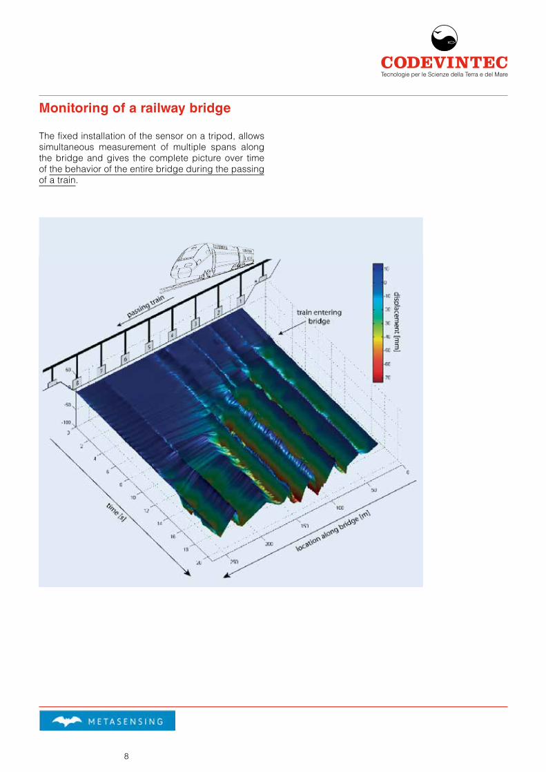
Monitoring of a railway bridge
The fixed installation of the sensor on a tripod, allows simultaneous measurement of multiple spans along the bridge and gives the complete picture over time of the behavior of the entire bridge during the passing of a train.
CODEVINTECTecnologie per le Scienze della Terra e del Mare

9
CODEVINTECTecnologie per le Scienze della Terra e del Mare
The FastGBSAR Ranger software is the new software for the real-time processing and visualization of the SAR mode FastGBSAR data, developed specifically for the mining environment and for monitoring critical structures and slope stability.
Thanks to its user friendly interface the user can obtain a complete picture of critical areas at first glance.
Data analysis is simple and fast, allowing for time series analysis, estimated time of failure calculation, quality parameter inspection and alarm display.
The software includes planar and 3D view for easy data visualization on a Digital Terrain Model.
FastGBSAR – Ranger SoftwareThe new software for real-time processing
Multiple parameters time series can be displayed by selecting several pixels on the maps. In just a few seconds all time series plots and all maps are automati- cally updated as new data are available. Figure shows an example of analysis in a case of a rock fall.
With the 3D view of the Ranger software the FastGBSAR displacement maps can be displayed on a Digital Terrain Model (DTM) of the area.Several maps can be superimposed thanks to the use of layers and transparency.
FastGBSAR in open-pit mine
3D tab with a displacement map over a DTM of the observed areaAnalysis tab with multiple parameters time series and synchronized planar view

10
Key Features
> Appealing graphical user interface > Simultaneous visualization of displacement maps,
quality parameters and time series > Straightforward processing of the FastGBSAR
radar data > Processing results available in a few seconds > Data download and storage handling > Real time processing and back analysis > Time of failure estimation > Planar and 3D view > Alert system for situational awareness
Visualization
The user can easily navigate through different tabs of the graphical interface, each one equipped with spe-cific tools for data visualization. All plots are synchro-nized and can be explored by zooming and panning. Simply passing the mouse over the map will show the pixels geographical coordinates and value.
> Home system log and information > Images simultaneous data quality parameter and
coherency visualization > Analysis displacement maps, multiple time series
analysis, time of failure estimation > Alarms alarms visualization and information > 3D visualization of the displacement maps and
quality parameters on the 3D model of the surface
Alarms
The FastGBSAR Ranger encompasses an early warn-ing system for safe operation in the monitored surface:
> Visual alarm messages and e-mail alerts > Alarm raising based on maximum displacement
and loss of coherency > Critical areas display > Continuous update > Statistics
Images tab with multiple quality parameters on a planar view
3D view of displacement over DEM
3D view of interferogram over DEM
CODEVINTECTecnologie per le Scienze della Terra e del Mare
11
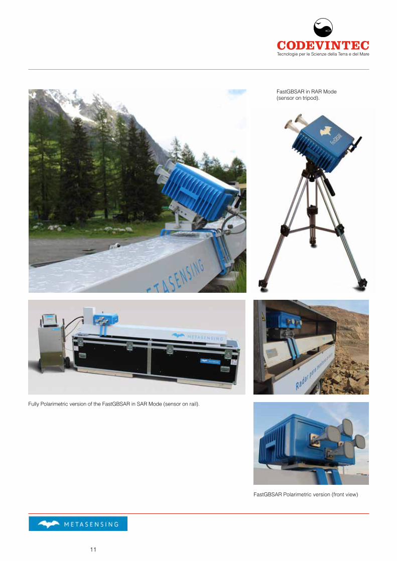
FastGBSAR in RAR Mode (sensor on tripod).
Fully Polarimetric version of the FastGBSAR in SAR Mode (sensor on rail).
FastGBSAR Polarimetric version (front view)
CODEVINTECTecnologie per le Scienze della Terra e del Mare

12
FastGBSAR – SAR mode
FastGBSAR – RAR mode
Land slope Water reservoir dam Open-pit mine Land slide
Telecom tower Wind turbines Bridge monitoring
CODEVINTECTecnologie per le Scienze della Terra
Codevintec Italiana srl Milano via Labus, 13 – 20147 Milano Roma Lungomare P.Toscanelli,64 – 00122 Roma
[email protected] ph +39 02 4830.2175 www.codevintec.it fax +39 02 4830.2169
© 2017 May - Codevintec Italiana srl, Milano