Embed Size (px)
Citation preview
METHOD 3 RISK CHARACTERIZATION
Former Lewis Chemical Corporation
0 & 12-24 Fairmount Court Hyde Park, MA
February 20, 2007
980 Washington Street, Suite 325 Dedham, MA 02026
(781) 251-0200 www.woodardcurran.com
Lewis Chemical (#218291) ii Woodard & Curran 218291_Method 3 RA_2-20-07.doc February 20, 2007
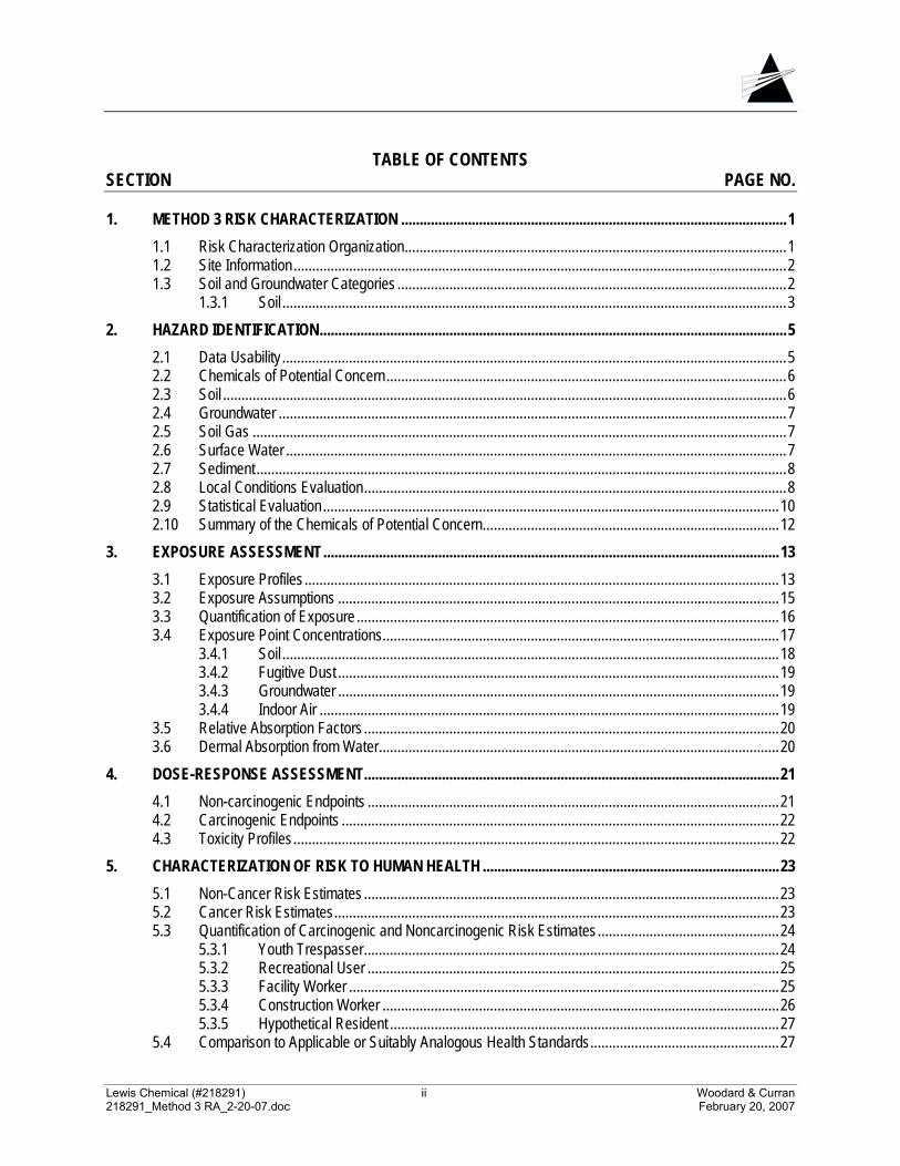
TABLE OF CONTENTS SECTION PAGE NO.
1. METHOD 3 RISK CHARACTERIZATION ........................................................................................................1 1.1 Risk Characterization Organization.......................................................................................................1 1.2 Site Information.....................................................................................................................................2 1.3 Soil and Groundwater Categories .........................................................................................................2
1.3.1 Soil ........................................................................................................................................3 2. HAZARD IDENTIFICATION..............................................................................................................................5
2.1 Data Usability ........................................................................................................................................5 2.2 Chemicals of Potential Concern............................................................................................................6 2.3 Soil ........................................................................................................................................................6 2.4 Groundwater .........................................................................................................................................7 2.5 Soil Gas ................................................................................................................................................7 2.6 Surface Water .......................................................................................................................................7 2.7 Sediment...............................................................................................................................................8 2.8 Local Conditions Evaluation..................................................................................................................8 2.9 Statistical Evaluation...........................................................................................................................10 2.10 Summary of the Chemicals of Potential Concern................................................................................12
3. EXPOSURE ASSESSMENT...........................................................................................................................13 3.1 Exposure Profiles ................................................................................................................................13 3.2 Exposure Assumptions .......................................................................................................................15 3.3 Quantification of Exposure ..................................................................................................................16 3.4 Exposure Point Concentrations...........................................................................................................17
3.4.1 Soil ......................................................................................................................................18 3.4.2 Fugitive Dust .......................................................................................................................19 3.4.3 Groundwater .......................................................................................................................19 3.4.4 Indoor Air ............................................................................................................................19
3.5 Relative Absorption Factors ................................................................................................................20 3.6 Dermal Absorption from Water............................................................................................................20
4. DOSE-RESPONSE ASSESSMENT................................................................................................................21 4.1 Non-carcinogenic Endpoints ...............................................................................................................21 4.2 Carcinogenic Endpoints ......................................................................................................................22 4.3 Toxicity Profiles...................................................................................................................................22
5. CHARACTERIZATION OF RISK TO HUMAN HEALTH ................................................................................23 5.1 Non-Cancer Risk Estimates ................................................................................................................23 5.2 Cancer Risk Estimates........................................................................................................................23 5.3 Quantification of Carcinogenic and Noncarcinogenic Risk Estimates.................................................24
5.3.1 Youth Trespasser................................................................................................................24 5.3.2 Recreational User ...............................................................................................................25 5.3.3 Facility Worker ....................................................................................................................25 5.3.4 Construction Worker ...........................................................................................................26 5.3.5 Hypothetical Resident .........................................................................................................27
5.4 Comparison to Applicable or Suitably Analogous Health Standards...................................................27

Lewis Chemical (#218291) iii Woodard & Curran 218291_Method 3 RA_2-20-07.doc February 20, 2007
6. CHARACTERIZATION OF RISK TO SAFETY...............................................................................................29
7. CHARACTERIZATION OF RISK TO PUBLIC WELFARE .............................................................................30
8. CHARACTERIZATION OF RISK TO THE ENVIRONMENT ..........................................................................31 8.1 Habitat Description..............................................................................................................................31 8.2 Stage I Screening ...............................................................................................................................32 8.3 Upper Concentration Limits.................................................................................................................32 8.4 Conclusions of the Environmental Risk Characterization....................................................................33
9. UNCERTAINTY ANALYSIS............................................................................................................................34 9.1 Hazard Identification ...........................................................................................................................34 9.2 Exposure Assessment ........................................................................................................................34 9.3 Dose-Response Assessment..............................................................................................................35 9.4 Human Health Risk Characterization ..................................................................................................36 9.5 Safety, Public Welfare and the Environment.......................................................................................36
10. CONCLUSIONS ..............................................................................................................................................37 10.1 Human Health .....................................................................................................................................37 10.2 Safety, Public Welfare and Environmental Risk Characterization.......................................................37
11. REFERENCES................................................................................................................................................39
LIST OF TABLES 1. Occurrence, Distribution and Selection of Chemicals of Potential Concern - Soil 2. Occurrence, Distribution and Selection of Chemicals of Potential Concern - Groundwater 3. Occurrence, Distribution and Selection of Chemicals of Potential Concern – Soil Gas 4. Occurrence, Distribution and Selection of Chemicals of Potential Concern - Sediment 5. Sediment Local Conditions Evaluation 6. Summary of the Chemicals of Potential Concern
a. Soil b. Groundwater c. Soil Gas d. Sediment
7. Exposure Assessment Summary 8. Values used for Daily Intake Calculations: Soil 9. Values used for Daily Intake Calculations: Fugitive Dust 10. Values used for Daily Intake Calculations: Groundwater 11. Values used for Daily Intake Calculations: Air 12. Values used for Daily Intake Calculations: Sediment
Lewis Chemical (#218291) iv Woodard & Curran 218291_Method 3 RA_2-20-07.doc February 20, 2007
13. Adult Lead Methodology: Facility Worker Scenario a. Site-wide Exposures b. Hot Spot #2
14. Adult Lead Methodology: Construction Worker Scenario a. Site-wide Exposures b. Hot Spot #2
15. Summary of Exposure Point Concentrations a. Site-Wide Exposures: Current b. Site-Wide Exposures: Future c. Hot Spot #1 d. Hot Spot #2
16. Relative Absorption Factors for Soil 17. Constituent-Specific Parameters Used in Estimating Dermal Absorption from Water 18. Calculation of the Dermal Absorption Factor for Aqueous Exposures 19. Noncancer Toxicity Data-Oral/Dermal 20. Noncancer Toxicity Data-Inhalation 21. Cancer Toxicity Data- Oral/Dermal 22. Cancer Toxicity Data - Inhalation 23. Summary of Total Hazard Indices and Risk Estimates
a. Site-wide Exposures b. Hot Spot #1 c. Hot Spot #2
24. Comparison of Soil and Groundwater Concentrations to MCP Upper Concentration Limits a. Soil b. Groundwater
25. Stage I Ecological Risk Characterization Screening
LIST OF ATTACHMENTS Attachment 1: Local Conditions Sediment Data Attachment 2: Local Conditions Evaluation-Statistical Output Attachment 3: Johnson & Ettinger Vapor intrusion Model Attachment 4: Estimation of Ambient Air Concentrations: Trench Model Attachment 5: Toxicity Profiles Attachment 6: Risk Calculations Attachment 7: IEUBK Model Output
Lewis Chemical (#218291) 1 Woodard & Curran 218291_Method 3 RA_2-20-07.doc February 20, 2007
1. METHOD 3 RISK CHARACTERIZATION A characterization of risk to human health, safety, public welfare, and the environment was completed for the Disposal Site (the “Site”) located at 0 & 12-24 Fairmount Court in Hyde Park, Massachusetts as part of a Phase II Comprehensive Site Assessment (CSA), in accordance with 310 CMR 40.0835(4)(h). This risk characterization has been performed in accordance with procedures outlined in the Massachusetts Contingency Plan (MCP; 310 CMR 40.0900) and in a manner consistent with scientifically acceptable risk assessment practices established by the Massachusetts Department of Environmental Protection (MADEP) and United States Environmental Protection Agency (USEPA). Under the MCP, risk characterizations are performed in accordance with one of three methods. Method 1 and Method 2 risk characterizations use promulgated MCP standards to characterize potential risks; these two methods are used to evaluate disposal sites where only soil and groundwater impacts have occurred, and such impacts are not likely to migrate to or exist in any other environmental medium. A Method 3 risk characterization uses detailed site-specific information to quantitatively assess cumulative noncancer and cancer risks, and can be used at any site. For this Site, a Method 3 risk characterization was selected, due to the presence of oil and/or hazardous material (OHM) in surface water and sediment, as well as the potential for vapor migration of OHM into indoor air. This risk characterization assesses cumulative noncancer and cancer risks at the Site in support of MCP Response Actions. This risk characterization was based on analytical data and other information provided to Woodard & Curran by Environmental Strategies & Management (ES&M), and is appended to the Phase II CSA prepared by ES&M.
1.1 RISK CHARACTERIZATION ORGANIZATION
The Method 3 risk characterization is organized as follows:
• Human Health Risk Characterization evaluates potential human receptors and exposure pathways and quantitatively evaluates the risk of harm to human health from exposure to site-related impact. The human health risk characterization consists of four main components: hazard identification, exposure assessment, dose-response assessment, and risk characterization;
• Characterization of Risk of Harm to Safety identifies and evaluates the potential current and
reasonably foreseeable presence of a threat of physical harm or bodily injury;
• Characterization of Risk of Harm to Public Welfare identifies and evaluates potential current and reasonably foreseeable nuisance conditions, loss of property use, unilateral restriction of the use of another person’s property, and any non-pecuniary effects related to the degradation of public resources;
• Characterization of Risk of Harm to the Environment identifies potential current and reasonably
foreseeable chemical distribution and potential routes of exposure, characterizes the populations exposed, and determines the risk of harm to ecological receptors from contaminants at or from the Site; and
Lewis Chemical (#218291) 2 Woodard & Curran 218291_Method 3 RA_2-20-07.doc February 20, 2007
• Uncertainty Analysis identifies the nature, direction and, when possible, the magnitude of the uncertainty associated with the risk characterization.
Each of these components are then brought together to present the conclusions of the Method 3 risk characterization.
1.2 SITE INFORMATION The former Lewis Chemical Company, located on Fairmount Court in Hyde Park, MA, is an approximately one-half acre vacant industrial property, comprised of a multi-story mill building/warehouse and partially paved surrounding areas once used for parking and storage. The property is located within an area of commercial, private business, recreational and residential usage. The property is bordered by Fairmount Avenue to the north; the Neponset River to the south and east; and an active train line to the west. A site locus map is provided as Figure 1 of the Phase II CSA report, to which this risk characterization report is attached.
As previously described in the Phase II CSA, the subject property has a long history of industrial use. Most recently, Lewis Chemical Company operated at the property from 1963 to 1983. Operations included the collection, storage, processing and transportation of hazardous waste. In 1983, the facility closed under a Court Order issued by the MADEP as a result of numerous state and federal violations of chemical storage, transportation and handling laws.
Environmental investigations have been conducted at the subject property since 1986; the property was first listed as a Disposal Site by the DEP in 1987 and is currently classified as a Tier 1B site. Most recently, ES&M has conducted environmental assessment activities in support of Phase I and Phase II investigations under the MCP, as described in the Phase II CSA, to which this risk characterization is appended.
The Disposal Site is defined in the Phase II CSA as the entire subject property and a portion of the Neponset River adjacent to the property. OHM has been identified in soil, groundwater and soil gas on the subject property, and sediment of the Neponset River adjacent to the Site. Types of constituents identified in these media include volatile organic compounds (VOCs), semi-volatile organic compounds (SVOCs), including polycyclic aromatic hydrocarbons (PAHs), polychlorinated biphenyls (PCBs), petroleum hydrocarbons and heavy metals.
1.3 SOIL AND GROUNDWATER CATEGORIES
This section identifies and documents the soil and groundwater categories applicable to the Site, as described in 310 CMR 40.0930. In a Method 3 risk characterization, rather than being used to characterize risks (as in a Method 1 or Method 2), these soil and groundwater categories are considered to be only general indicators of the potential for exposure to oil and hazardous material (OHM) in these media.
Lewis Chemical (#218291) 3 Woodard & Curran 218291_Method 3 RA_2-20-07.doc February 20, 2007
1.3.1 Soil The MCP specifies three soil categories (S-1, S-2, and S-3). Category S-1 soil represents the highest potential for exposure because it assumes the unrestricted use of the soil (i.e., residential), whereas Category S-3 soil represents the lowest potential for exposure. Currently, the Site is an inactive industrial facility located on a parcel of land zoned for commercial/industrial use. Furthermore, the Site is in a somewhat remote area and is surrounded by a secured fence. It is unlikely that children would be routinely present at the Site at a high frequency or engage in high intensity activities, given the Site’s industrial location and relative inaccessibility. Soils at the Site are partially paved and/or covered by buildings, or covered with debris and vegetation. Pavement, if present, is generally in poor condition. Under current conditions, soils located beneath the building or at depths greater than 15 feet bgs are considered isolated and are categorized as S-3. Soils located within 0-3 feet bgs are considered as potentially accessible and are classified as S-2. For this evaluation, we have assumed that no deed restrictions will be placed on the Site that would prevent high-intensity future land uses by either adults or children, and that impacted subsurface (i.e., greater than 3 feet below ground surface [bgs], but less than 15 feet bgs) soil in this portion of the Site may potentially be brought to the surface under future conditions. Thus, all Site soil located between 0-15 feet bgs is classified as S-1 for future land uses. (Soil located at depths greater than 15 feet bgs remains classified as S-3.) 1.3.1.1 Groundwater MADEP has established three categories for groundwater, which may apply to a specified volume of groundwater at the Site or to an aquifer taken as a whole. These groundwater categories were established to identify groundwater associated with the following three distinct types of exposures:
• GW-1 applies to groundwater assumed to be a potential source of drinking water. • GW-2 applies to groundwater considered to be a potential source of vapors that could migrate
through the subsurface and concentrate in indoor air of on-Site buildings.
• GW-3 applies to groundwater that is assumed to discharge to surface water. Groundwater at the Site is not a current or potential source of drinking water, as demonstrated by the consideration of the seven MCP criteria for GW-1 classification: groundwater is not within a Zone II or within an Interim Wellhead Protection Area (IWPA) for a public water supply; groundwater is not within a Potentially Productive Aquifer (medium to high yield) that has not been excluded as a non-potential Drinking Water Source Area; groundwater is not within the Zone A of a Class A Surface Water Body used as a public water supply; and groundwater is not within an area designated by a municipality specifically for the protection of groundwater quality to ensure its availability for use as a source of potable water. Furthermore, the Site is located less than 500 feet from a public water supply distribution pipeline, and is greater than 500 feet from a private drinking water supply well. Therefore, groundwater is not classified as GW-1. Depth to groundwater at the Site is moderately shallow (i.e., less than 15 feet below ground surface (bgs)) and, although the on-site building is currently vacant, it is likely that the property will be redeveloped and occupied in the future. Under reasonably foreseeable conditions, groundwater at the Site is classified as
Lewis Chemical (#218291) 4 Woodard & Curran 218291_Method 3 RA_2-20-07.doc February 20, 2007
GW-2. As such, volatile constituents present in shallow groundwater may potentially migrate from the subsurface into indoor air of a future on-site building. All groundwater in the Commonwealth is classified as GW-3, which assumes that Site groundwater will ultimately migrate and discharge to a surface water body. The nearest surface water feature to the Site is the Neponset River, which abuts the Site to the south and east. In summary, groundwater at the Site is classified as GW-2 and GW-3.
Lewis Chemical (#218291) 5 Woodard & Curran 218291_Method 3 RA_2-20-07.doc February 20, 2007
2. HAZARD IDENTIFICATION The objective of the Hazard Identification is to present the relevant sampling data and select the Chemicals of Potential Concern (COPCs) for each medium. This section summarizes the Site analytical data used to qualify and quantify the potential risks associated with exposure to each detected chemical in impacted media at the Site. Soil, groundwater, soil gas, surface water and sediment data were collected at the Site as part of Phase I/II response actions conducted by ES&M between 2002 and 2006. Analytical results discussed herein are based primarily on these data. Additionally, we also used Neponset River data collected by the United States Geological Survey (USGS), as presented in the following report:
Breault, R.F., Cooke, M. G., and Merrill, M. 2004. Data on Sediment Quality and Concentrations of Polychorinated Biphenyls from the Lower Neponset River, Massachusetts, 2002-2003. U.S. Geological Survey Open File Report 2004-1280, 55p.
Figures 2-5 of the Phase II CSA Report, to which this report is appended, depict the Disposal Site boundaries and sample locations.
2.1 DATA USABILITY For this risk characterization, we generally considered all available Site data as useable, with a few exceptions. Data not included in our evaluation are described by medium in the following sections. Below, we summarize the general treatment of the data.
Duplicate Samples/Analyses: Where duplicate samples were collected, we used the maximum detected concentration (if detected) or minimum laboratory reporting limit (LRL) between the primary and duplicate sample results. Likewise, where a constituent was analyzed via more than one analytical method (e.g., naphthalene was analyzed via EPA 8260 and MADEP VPH), we used the maximum detected result or minimum LRL among the various results. For constituent results reported by isomer (e.g., o-xylenes and p/m-xylenes), we summed the results from the separate isomers and reported one ‘total’ compound result (e.g., total xylenes). Polychlorinated biphenyl data was evaluated using individual aroclor data rather than ‘total PCB’ results.
Elevated detection limits: Some of the samples were diluted during analysis due to high concentrations of constituents. Consequently, detection limits in such samples may have been elevated relative to typical LRLs among other sample results. We excluded these elevated LRLs only in instances where the LRL exceeded twice the maximum detected concentration in a medium.
Temporal Sampling: For monitoring wells in which more than one sampling event has been conducted, we calculated a “temporal average” groundwater concentration for each sample location. These temporal average concentrations for wells within each area of the Site were then used as the basis for the average concentrations; however, the minimum and maximum detected values and frequencies of detection reported in data summary tables generally reflect all discrete sampling events.
Calculation of Averages: In calculating the average concentration for all media, we included one-half of the LRL as the concentration for non-detect results, with one exception. For non-detect results where the LRL exceeded twice the maximum detected concentration of a given dataset, we excluded that LRL from calculation of the mean, as previously described.
Lewis Chemical (#218291) 6 Woodard & Curran 218291_Method 3 RA_2-20-07.doc February 20, 2007
2.2 CHEMICALS OF POTENTIAL CONCERN Please refer to the Phase II CSA, to which this report is appended, for a detailed explanation of the nature and extent of contamination at the Site. This section contains only a brief description of the nature and extent of the OHM identified at the Site, which is presented in the following sections by environmental medium. Additionally, the chemicals of potential concern (COPCs) are identified for further evaluation in the risk characterization. COPCs are those constituents detected at the Site that will be carried through the risk characterization.
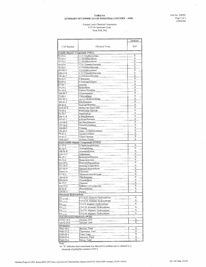
2.3 SOIL Data from sixty-one soil samples are available to represent soil quality at the Site. These data are summarized in Table 1. Soil samples were analyzed for VOCs, volatile and extractable petroleum hydrocarbons (VPH/EPH), polycyclic aromatic hydrocarbons (PAHs), heavy metals, and polychlorinated biphenyls (PCBs; as aroclors). Concentrations of VOCs were generally highest in samples collected in the eastern portion of the Site. Two distinct areas of the site were identified as VOC Hot Spots, due to elevated concentrations of VOCs in soil. Under the MCP, a Hot Spot is defined as a discrete area where the concentrations of oil or hazardous material are substantially higher than those concentrations in the surrounding area1. Hot Spot #1 is located by the southeastern corner of the building and is represented by soil sample II-A-03M (5-7’). Hot Spot #2 is located near the northeastern corner of the building and is represented by soil samples ESM-03 (10-12') and II-A-09D (13'-14'). These hot spots are depicted on Figure 4 in the Phase II CSA report to which this risk characterization is attached. Concentrations of other constituents (metals, PAHs, PCBs, PAHs) were variable, however, across the Site, indicating a heterogeneous lateral and vertical pattern of contamination. Highest concentrations of these constituents, however, were generally found in subsurface (i.e., greater than three feet bgs) soils, with the exception of certain PAHs and PCB Aroclors 1248 and 1254. Criteria considered in the selection of COPCs included frequency of detection and relevance to background levels. Any constituent detected at least once in samples of a particular medium at a frequency greater than 5% (in 20 or more samples) was retained as a COPC. Several VOCs and the PCB aroclor 1254 were excluded based on low frequency of detection. We compared maximum detected concentrations of constituents in soil to MADEP background levels for “natural” soils (MADEP, 2002a); constituents present at levels above the background level were retained as COPCs. Table 1 indicates COPCs in soil. As shown, concentrations of arsenic and cadmium are present at levels consistent with background levels and thus were excluded as COPCs for this risk assessment.
1 A Hot Spot is identified based on consideration of both the concentrations of a chemical within a contaminated area and the spatial pattern of that contamination. A discrete area where the concentration of an oil or hazardous material is greater than one hundred times the concentration in the surrounding area is considered a Hot Spot at the Site. Smaller differences in concentrations were not considered Hot Spots because (a) there is no evidence that areas of the Site have greater exposure potential than the surrounding area and (b) much of the data from the Site show a high variability in site concentrations.
Lewis Chemical (#218291) 7 Woodard & Curran 218291_Method 3 RA_2-20-07.doc February 20, 2007
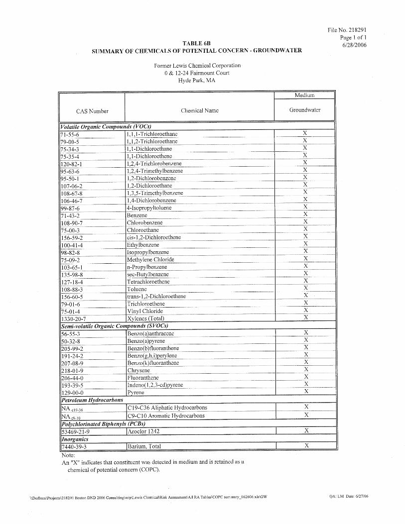
2.4 GROUNDWATER
Groundwater from permanent monitoring wells has been monitored at the Site on two occasions (2002 and 2006). As previously discussed, for wells that have been sampled during both the 2002 and 2006 rounds, we calculated a “temporal average wellhead” concentration for use in the risk characterization to reflect average concentrations over the time period.
Groundwater analytical results are summarized in Table 2. As indicated, VOCs, PAHs, petroleum hydrocarbon fractions, barium, and aroclor 1242 were detected in groundwater. Highest concentrations of VOCs (in particular, chlorinated VOCs) were generally detected near the eastern portion of the Site; however, elevated concentrations of non-chlorinated VOCs and petroleum hydrocarbons were also detected in the western portion of the Site by the railroad tracks, in the vicinity of the former fuel oil underground storage tank.
Two VOC hot spots were identified in Site groundwater; these hot spots are co-located with the two soil hot spots. Hot Spot #1 is represented by monitoring wells ESM-5, ESM-6, ESM-15, PZ-02, ESM-9, B1/0W-1; Hot Spot #2 is represented by monitoring wells ESM-3, PZ-01, PZ-03. Figure 3 of the Phase II CSA indicates the location of these two hot spots. Elevated concentrations of PCBs dissolved in groundwater are also present within these Hot Spots; it is theorized that the PCBs detected in groundwater in this area of the Site are attributed to the high levels of chlorinated solvents co-located in groundwater and that these solvents are essentially ‘extracting’ the PCBs from the soil matrix. The source of these PCBs is likely related to historical releases to the former tank farm drain (where PCBs were detected in drain sludge; see Section 5.3.3 of the Phase II report).
As some of the highest VOC concentrations were detected in wells along the eastern edge of the subject property, and along the bank of the Neponset River, ES&M installed four additional piezometers along the banks of the Neponset River (PZ-4, PZ-5 and PZ-6 on the opposite bank and PZ-7 on the adjacent bank by the Fairmount Avenue bridge) in November 2006 in order to evaluate the horizontal extent of the groundwater VOC plume (see Figure 3). These data are summarized in Table 3.5 of the Phase II CSA. No constituents were detected in PZ-4 and PZ-5 (located on the opposite bank); only methyl-tert-butyl ether (MTBE) was detected in PZ-6, which is the most upstream well. The data suggest that the river is acting as a barrier to lateral migration under the river of VOCs in groundwater; the presence of MTBE in well PZ-6 may potentially be related to an unknown (petroleum) source of OHM on the opposite bank. Relatively low levels of chlorinated VOCs were detected in well PZ-7, on the adjacent bank and downstream of the Lewis Chemical facility.
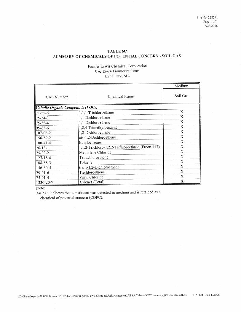
2.5 SOIL GAS
ES&M collected six soil gas samples (SG-1 through SG-6) from beneath the slab of the existing on-site building in April 2006 in order to evaluate potential vapor migration of VOCs from the subsurface. Results are summarized in Table 3. VOCs were detected in all six samples; the highest concentrations of most VOCs were detected in samples SG-6 and SG-4, located near Hot Spots #1 and #2, respectively. However, concentrations of VOCs were relatively consistent among all samples.
2.6 SURFACE WATER
ES&M collected surface water data from the Neponset River in 2002 and 2006. Samples were analyzed for VOCs and heavy metals in 2002; and for VOCs in the 2006 sampling round. We did not include the 2002

Lewis Chemical (#218291) 8 Woodard & Curran 218291_Method 3 RA_2-20-07.doc February 20, 2007
surface water data in our evaluation as the 2006 VOC data represent the most recent conditions in the river. No VOCs were detected in surface water collected in 2006. Although barium and lead (as total metals) were detected in 2002 results, we did not include these results in our evaluation as only trace concentrations were detected at levels just at or below the reporting limit. Thus, surface water was ruled out as a medium of concern for this Site.
2.7 SEDIMENT
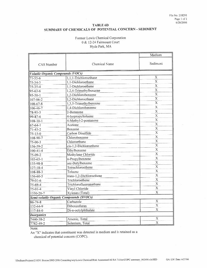
ES&M collected 12 sediment samples from the Neponset River during the 2002 and 2006 sampling events in areas both adjacent to and upstream of the Site. The collected sediment samples were analyzed for VOCs, SVOCs/PAHs, and/or metals. A summary of sediment analytical results for samples collected adjacent to the Site is presented as Table 4. Results indicate that PAHs and heavy metals were detected in most of the samples analyzed2. VOCs were detected in up to five of the “Site” sediment samples analyzed for this group of compounds. Highest concentrations of VOCs were generally detected in samples collected near the shore of the site by Hot Spot #1 (sample SED-SH; S-3) and Hot Spot #2 (sample S-6).
All VOCs detected in sediment are assumed to be related to releases from the Site and were retained as COPCs in sediment. For the other constituents detected, we evaluated concentrations of these contaminants with respect to upstream, or “local” conditions, as discussed in the following section.
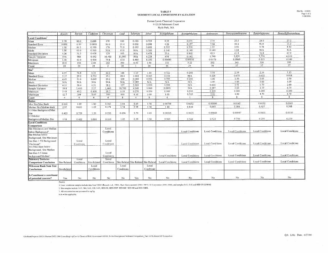
2.8 LOCAL CONDITIONS EVALUATION
The Neponset River winds through mixed residential, commercial and industrial areas from its source in Foxborough, MA to its mouth at Boston Harbor. Over time, much of the Neponset’s banks and bordering wetlands have been altered or filled in, and the river has been subject to both point and non-point sources of pollution, from industrial and municipal discharges to roadway run off and erosion. Numerous hazardous waste sites are also present along the Neponset River. Consequently, water and sediment quality in this waterway has been impacted by a variety of contaminants. This baseline level of contamination is referred to as “local conditions”.
As discussed in the previous section, heavy metals and PAHs were detected in sediments collected adjacent to and upstream of the Site. To determine whether the levels of these constituents are similar to those detected in upstream locations, we conducted a statistical evaluation of Neponset River sediment data, based on the data collected by ES&M, USGS (Breault et al. 2004), and Shaw Environmental (Shaw, 2004, 2005; IT 2001, 2002). We focused our evaluation on the stretch of river between the Site and the upstream LE Mason Facility disposal site located on Mother Brook, a channel that enters the Neponset River approximately 200 meters upstream of the Former Lewis Chemical Corporation site. Response actions conducted at the LE Mason site, a known source of PCB impact to Mother Brook and downstream areas, included the excavation of soil and the dredging and removal of streambed sediments over a stretch of river adjacent to and downstream of the facility. We also included USGS sediment data collected from the Neponset River upstream of the Mother Brook confluence. USGS/LE Mason local conditions sediment data are presented in Attachment 1. USGS Dataset: The USGS collected sediment-grab samples at 20 sites along the Neponset River. Samples BGY-100 through BGY-104 were collected upstream of the Mother Brook confluence; samples 2 As described further in Section 2.8, several documented disposal sites upstream are located upstream of the study area. Data collected by other entities suggest a baseline level of contamination along the length of the Neponset River. It is therefore unclear at this time if these constituents are related to former Site releases.

Lewis Chemical (#218291) 9 Woodard & Curran 218291_Method 3 RA_2-20-07.doc February 20, 2007
BGY-105 through BGY-133 were collected downstream of the confluence to the Walter Baker Dam in Milton, MA, located several miles downstream of the Site. USGS did not collect sediment samples from Mother Brook; therefore, no sediment data were collected relative to the LE Mason site. None of the USGS sediment samples was collected adjacent to the Former Lewis Chemical Site. USGS samples were analyzed for aroclors, metals, organochlorine pesticides and/or PAHs. Metals and PAH concentrations appear to be relatively consistent throughout the river, with occasional peaks immediately downstream of the confluence and at the Tileston and Hollingsworth (T&H) Dam and Walter Baker Dam. Organochlorine pesticides were not detected in any of the sediment samples collected along this stretch of river (Breault et al., 2004). Concentrations of total PCBs in the USGS data set range from below detection limits to 10.6 mg/kg at BGY-105, downstream of the Mother Brook confluence and upstream of the Former Lewis Chemical Corporation building. Concentrations of total PCBs generally appear to be higher in the stretch of the river between BGY-105 (located just downstream of the confluence) and the T&H Dam. Discussions with Robert Breault, USGS (2006), indicate that USGS has recently characterized sediment quality in Mother Brook (data not currently available) as well as additional points in the Lower Neponset, and that PCB concentrations are elevated in this waterway relative to the Neponset River. Furthermore, this study found that PCB congener patterns in many of the sediment samples (including recent samples collected by the Site) are similar to those found by the LE Mason facility. Results from this additional study suggest that PCBs from the LE Mason disposal site may have impacted sediments throughout the Neponset River from the Mother Brook confluence to Boston Harbor. Once the additional USGS PCB data are made publicly available, we will further evaluate these data with respect to local conditions. LE Mason Dataset: Between March and September, 2000, Shaw (then IT Corporation) conducted several rounds of sediment sampling in Mother Brook upstream and adjacent to the L.E. Mason Facility. Samples collected upstream of the LE Mason facility (SD-1 through SD-3 and U-1 through U-12) indicated detectable levels of PAHs, EPH, PCBs and metals. Concentrations of VOCs, PAHs, PCBs, EPH/VPH and metals were also detected adjacent to the L.E. Mason Facility. PCB concentrations in soil and sediment were highly elevated adjacent to the facility, with concentrations of total PCBs up to 4,600 mg/kg (IT, 2001). In August, 2001, an Immediate Response Action (IRA) was conducted in Mother Brook by Shaw (then IT Corp.) to excavate soil and sediment adjacent to the L.E. Mason Site for remediation of PCBs. Impacted soil and sediment were excavated up to a maximum depth of 14 feet. The brook bed was backfilled and restored to its previous elevations; the average concentration of PCBs remaining in the top two feet of soil and sediment over the remediation area was below the target clean-up goal of 3 mg/kg. (IT Group, April 26, 2002. Immediate Response Action Completion Report Mother Brook, L.E. Mason Company; Project # 830408-2002; Table 7 and Figure 12) Following the IRA, Shaw collected additional sediment samples (SED-1 through SED-42) along 11 transects (approximately 100 feet of waterway) in Mother Brook downstream from the L.E. Mason Site, between the Amtrak Bridge and 50 feet upstream of the confluence of Mother Brook and the Neponset River. These sediment samples were analyzed for total PCBs. Concentrations of PCBs ranged from non-detect to 104 mg/kg at sample location SD-27 (Shaw, December, 2004. Phase II/III Comprehensive Site Assessment and Remedial Action Plan Addendum; Tables 2 and 6, Appendix E and Figures 3, 4 and 5)). An extensive remediation of 1,800 linear feet of Mother Brook downstream of the Amtrak Bridge is scheduled for the summer of 2006. (Shaw, June 30, 2005. Notice of Intent, Phase IV – Remedy Implementation Plan Regulatory Permitting Support Document).
Lewis Chemical (#218291) 10 Woodard & Curran 218291_Method 3 RA_2-20-07.doc February 20, 2007
2.9 STATISTICAL EVALUATION Site Sediment concentrations were compared to local conditions following the procedure described in MCP Guidance (MADEP, 1995). Site sediment data were grouped and summary statistics were calculated for the results, which include ½ the detection limit for non-detect results, when ½ the detection limit was less than the maximum detected. Summary statistics for local conditions data were also generated, using the same rules. The results of these statistics are provided on Table 5. At this point in time, there are no publicly available sediment data3 from the section of the Neponset River adjacent to the Site that characterizes PCB concentrations in Site sediment relative to local conditions. Thus, the local conditions evaluation was conducted for only PAHs and heavy metals. All detected VOCs are assumed to be related to the Disposal Site and were retained as COPCs. (PCB levels in the Neponset River adjacent to the Site will be evaluated with respect to local conditions when the USGS data are made publicly available.) As per MADEP guidance (1995), the initial step in the local conditions evaluation was to select statistical measures representative of central-tendency and upper-bound concentrations in each dataset. Accordingly, the median and maximum values of each data set (i.e., “Site” and “Local Conditions”) were compared to evaluate whether site concentrations are consistent with local conditions. As recommended by MADEP (1995) the following conditions were used to determine if site levels are consistent with local conditions:
1. Maximum and median site concentrations are less than the maximum and median background concentrations. If only one Site statistic is less than background, one of the following must be true in order to conclude that the Site concentrations are consistent with Local Conditions.
2. Site median concentration is below the background median concentration, and the Site maximum concentration is less than 1.5 times background maximum concentration; or,
3. Site maximum concentration is below the background maximum concentration, and the Site median concentration is less than 1.5 times the background median concentration.
The summary statistics were calculated using Microsoft Excel's Data Analysis function. As shown on Table 5, each of the three conditions identified above were evaluated for each inorganic and SVOC constituent detected in Site sediment. The conclusion of the evaluation is identified in Table 5. Based on the comparison of summary statistics, arsenic, cadmium, lead, selenium and silver were identified as being at concentrations slightly above Local Conditions. In order to further refine the local conditions comparison for arsenic, lead, cadmium and silver, an additional comparison of Site to local conditions concentrations was performed in accordance with EPA’s “Guidance for Comparing Background and Chemical Concentrations in Soil for CERCLA Sites” (September 2002). Statistical methods used to compare to background generally include either parametric or non-parametric tests. Parametric statistical tests assume the data follow a known distribution, while non-parametric tests do not assume a specific underlying distribution. As described in EPA’s guidance (EPA, 2002), for data sets comprised of fewer than 20 samples, non-parametric tests should be used to avoid incorrectly assuming the data are normally or lognormally distributed when there may not be enough information. 3 Sediment data have been collected but have not yet been released by the USGS.
Lewis Chemical (#218291) 11 Woodard & Curran 218291_Method 3 RA_2-20-07.doc February 20, 2007
Because fewer than 20 site sediment samples were analyzed, the non-parametric Wilcoxon Rank Sum test, which compares medians of the data sets, was utilized. The Wilcoxon Rank Sum test, a non-parametric test that evaluates whether measurements from one data set is different from another set, ranks data from both sets together and compares the relative ranks of the two underlying data sets. The assumption is that the difference between local conditions and site data is due to a shift in the Site concentrations to higher values, due to Site contamination. This evaluation is more advanced than the simple comparison of medians performed above. The Wilcoxon Rank Sum test has been described by EPA as having three advantages for background comparisons:
1) The data sets are not required to be from a known type of distribution;
2) It allows for non-detect measurements to be present in both data sets; and,
3) It is robust with respect to outliers.
The Wilcoxon Rank Sum test was performed to test the null hypothesis (H0) that the median site sediment COPC data is equal to the median local conditions sediment data. If a sample result was non-detect, ½ of the detection limit was used as a surrogate. If the surrogate was greater than the maximum detected, it was not included in the analysis. The alternative hypothesis (HA) is that the median site sediment data do not equal the median background data. EPA recommends that for a relatively small site data set, an α = 0.20 (or an 80% confidence) is used. Wilcoxon Rank Sum tests were calculating using StatGraphics software (Manugistics, v. 5.1). Statistical outputs for the Wilcoxon Rank Sum test for arsenic, cadmium, lead and silver are provided in Attachment 2. Lead and silver were found to be at concentrations not significantly different from local conditions. Arsenic and selenium were found to be at concentrations significantly higher than local conditions. VOCs, arsenic, and selenium are therefore identified as the only site-related sediment COPCs, based on the datasets described herein. The table below summarizes the results of our local conditions evaluation:
Constituent Local Condition
Decision Volatile Organic Compounds Site-Related
Arsenic Site-Related Barium Local Conditions
Cadmium Local Conditions Chromium Local Conditions
Lead Local Conditions Selenium Site-Related
Silver Local Conditions Acenaphthene Local Conditions
Acenaphthylene Local Conditions Anthracene Local Conditions
Benzo(a)anthracene Local Conditions Benzo(a)pyrene Local Conditions
Lewis Chemical (#218291) 12 Woodard & Curran 218291_Method 3 RA_2-20-07.doc February 20, 2007
Constituent Local Condition
Decision Benzo(b)fluoranthene Local Conditions Benzo(g,h,i)perylene Local Conditions Benzo(k)fluoranthene Local Conditions
Chrysene Local Conditions Fluoranthene Local Conditions
Fluorene Local Conditions Indeno (1,2,3-cd)-pyrene Local Conditions
2-Methylnaphthalene Local Conditions Naphthalene Local Conditions
Phenanthrene Local Conditions Pyrene Local Conditions
Based on our evaluation of the available sediment data, we have concluded that all detected VOCs, arsenic and selenium are present in sediment adjacent to the site at levels exceeding those indicative of local conditions and thus are retained as sediment COPCs; all other detected constituents are attributed to local conditions and are not evaluated further in this risk characterization.
2.10 SUMMARY OF THE CHEMICALS OF POTENTIAL CONCERN
Tables 6a through 6d present a summary of the chemicals of potential concern by medium.
Lewis Chemical (#218291) 13 Woodard & Curran 218291_Method 3 RA_2-20-07.doc February 20, 2007
3. EXPOSURE ASSESSMENT
The objective of the Exposure Assessment is to estimate the type and magnitude of potential exposure to Site-related COPCs present at or migrating from the Site. Exposure is quantified for the populations potentially exposed to contaminated media via specific exposure pathways, based on current and future potential land use. The exposure estimates are calculated using chemical-specific exposure point concentrations (EPCs) and combined with dose-response information to characterize the potential risk to human receptors.
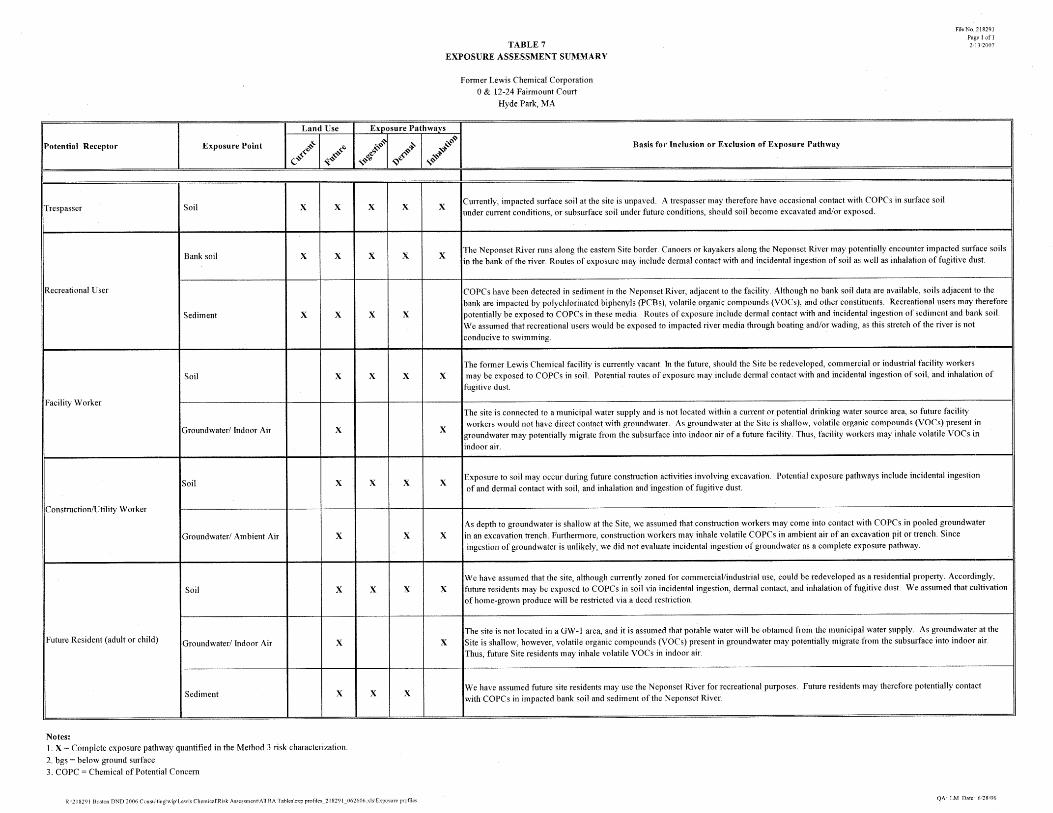
3.1 EXPOSURE PROFILES Complete and potentially complete exposure pathways were quantitatively evaluated as part of the human health risk characterization. A complete exposure pathway, which links COPCs in an environmental medium to a human receptor, consists of the following elements:
• a source and mechanism of chemical release; • a retention or transport medium; • a point of potential human contact (exposure point); and • an exposure route (e.g., dermal contact, ingestion, or inhalation).
Human exposure may be direct (i.e., the receptor contacts the COPC in the medium directly affected by site releases, such as air, water or soil) or may be indirect, involving exposure to chemicals from the Site through the food chain (for example, one may ingest COPC via consumption of fish or vegetables that have absorbed COPCs from contaminated media). The exposure assessment was conducted in a manner consistent with MADEP and USEPA risk characterization guidance (e.g., USEPA 1999, 2004; MADEP 1995; MADEP 2002 b,c,d). For each identified receptor at each exposure point, complete or potentially complete exposure pathways were identified based on Site activities and uses and the presence of COPCs in environmental media. Age groups that represent the longest or most intense exposure periods were selected to be adequately protective of all stages of the receptor’s life. The following exposure scenarios were therefore considered for the Site: Current/Future Trespasser Soil at the Site is partially paved and COPCs are present in exposed surface (i.e., 0-3’ bgs) soil. However, as previously discussed, the Site is surrounded by a locked fence and not readily accessible. For this evaluation, we have conservatively assumed that, under current conditions, trespassers at the Former Lewis Chemical Corporation property may potentially be exposed to COPCs in surface soil via incidental ingestion and dermal contact. Trespassers may also inhale COPCs entrained on dust particles. We assumed that in the future, subsurface soil may be brought to the surface during Site redevelopment. Thus, future trespassers may be exposed to both surface and subsurface (3-15’ bgs) soils. Current/Future Recreational User The Neponset River is a Class B waterway, suitable for swimming, boating and other recreational activities (310 CMR 4.00). Boaters on the Neponset River may potentially encounter COPCs in sediment
Lewis Chemical (#218291) 14 Woodard & Curran 218291_Method 3 RA_2-20-07.doc February 20, 2007
in the river, as well as on the banks of the river adjacent to the Site. Routes of exposure potentially include incidental ingestion of and dermal contact with sediment and bank soil4 and inhalation of fugitive dust from bank soil. We did not evaluate swimming-related exposures for this receptor, as this stretch of the Neponset is not conducive to swimming due to the steep vegetated banks and river current. Furthermore, surface water is not a medium of concern at this site. Recreational users were not assumed to encounter any upland soils at the Site, as the Site is fenced off behind the riverbank. Waders or boaters are not likely to access soils at this distance from the river, given the steep bank and presence of a fence at the property boundary and top of bank. As described above, we provided a separate evaluation for the trespasser scenario, in which a youth is exposed to COPCs in upland Site soils. Future Facility Worker Currently, the Site is vacant but will likely be redeveloped as commercial or industrial property in the future. We have therefore assumed that all impacted soils at the Site may become exposed. Future facility workers may potentially encounter COPCs in impacted soil via incidental ingestion, dermal contact and inhalation of fugitive dust. Due to the presence of VOCs in shallow groundwater and soil gas at the Site, we assumed future facility workers may also potentially inhale VOCs that have migrated from the subsurface into indoor air of a future (hypothetical) building. Hypothetical Future Resident We conservatively assumed that the Site may be redeveloped for residential use in the future. Thus, we quantified risks for a future residential scenario in which hypothetical Site residents may have dermal contact with or incidentally ingest COPCs in impacted soil and inhale COPCs entrained in fugitive dust. Due to the Site’s urban location, we did not quantify risks associated with the consumption of home-grown produce; instead, we assumed that this activity would be restricted through an Activity and Use Limitation. We assumed that residents may potentially inhale VOCs that have migrated from the subsurface into indoor air of a home. Additionally, given the close proximity of the Site to the river, we assumed that the resident may use the river for recreational purposes, and may therefore may be exposed COPCs in sediment and bank soil via dermal contact or incidental ingestion. Future Construction Worker During Site redevelopment activities, construction workers may be exposed to COPCs in soil or groundwater during activities requiring excavation. Potential routes of exposure include dermal contact with COPCs in soil and groundwater, and incidental ingestion of COPCs in soil. Construction workers may also inhale COPCs bound to air-borne particulates or VOCs in ambient air of an excavation trench. Incidental ingestion of contaminated groundwater was assumed to be unlikely, and was not evaluated for this scenario. The exposure profiles for the receptors evaluated in the risk characterization are summarized in Table 7. The relevant exposure assumptions for each of these scenarios are described in the following section.
4 It is unlikely that boaters would actually be exposed to bank soil by the Site, as the banks of the river are steep and generally covered with stone rip-rap and/or vegetation. However, we have conservatively assumed that bank soil is a medium of concern.
Lewis Chemical (#218291) 15 Woodard & Curran 218291_Method 3 RA_2-20-07.doc February 20, 2007
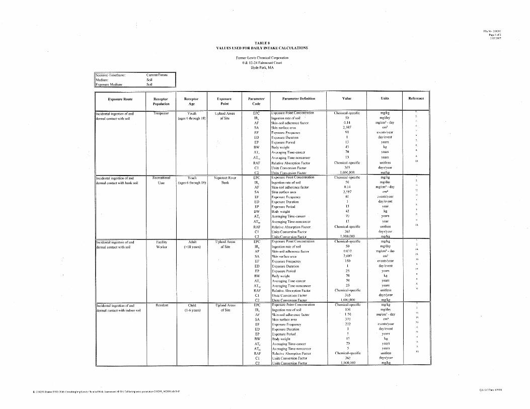
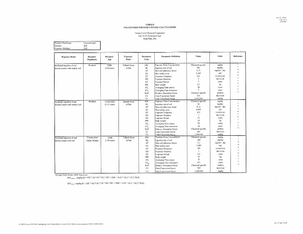
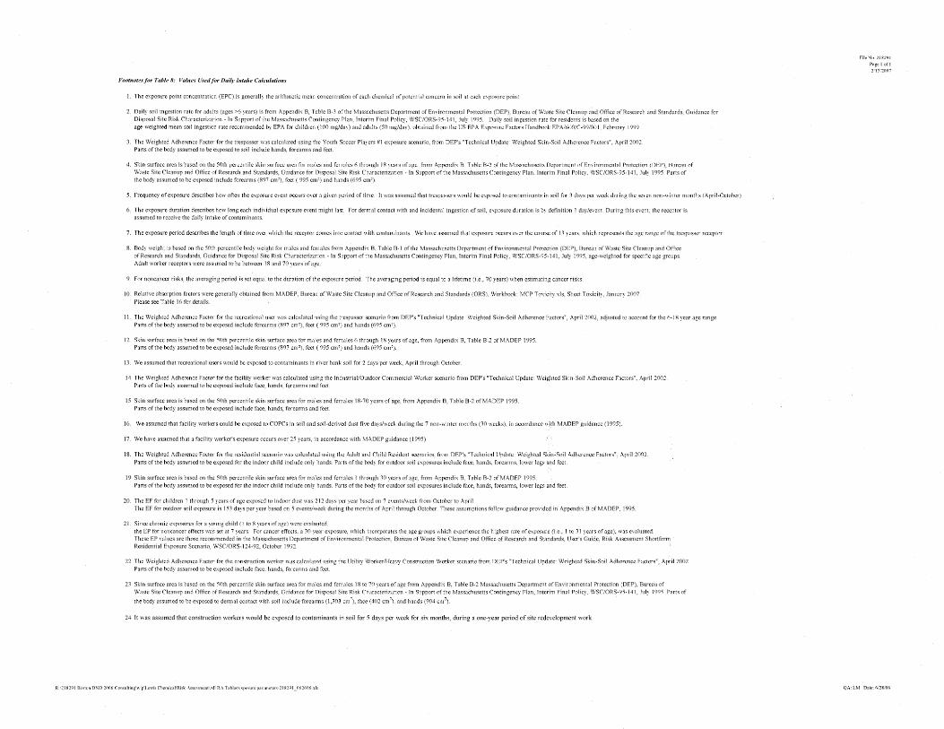
3.2 EXPOSURE ASSUMPTIONS The receptor-specific exposure assumptions for each medium of concern are presented in Tables 8 through 12. Generally, MADEP-recommended exposure parameters were used to calculate the exposure dose. Variables specific to each of the identified receptors are briefly described below. Trespasser For the trespasser scenario, we identified a youth of ages 6 to 18 years as the receptor most likely to have the highest level of exposure, assuming that children younger than 6 would be under parental supervision. Although adult trespassers may also access the Site, the youth age range of 6 to 18 years represents a more sensitive subpopulation5 and is thus protective of both adult and youth receptors. This age range results in an exposure duration of 13 years. W&C conservatively assumed that a trespasser would be present at the Site three days per week during the seven non-winter months (April through October) when the ground is not frozen and/or covered by snow and would come into contact with soil during each exposure event. For incidental ingestion of soil and sediment, W&C assumed that a trespasser would receive the full dose of soil from the Site and ingest 50 mg soil per day. This value is the daily soil ingestion rate recommended for this age group by MADEP (1995). The skin surface area used to evaluate dermal exposures to soil and sediment for the trespasser scenario assumed that the hands, forearms and feet would be exposed during a Site visit, to reflect exposures typical of walking across the Site. The 50th percentile surface area of male and female children ages 6 to 18, based on the assumed body parts, was used to estimate daily dermal intake rates (MADEP, 1995). The soil adherence factor of 0.14 mg/cm2 was based on the MADEP’s recommendation for a trespasser scenario (MADEP, 2002b), which W&C assumed was representative of typical outdoor exposures anticipated for this age group. Recreational User For the recreational user scenario, we used soil exposure assumptions similar to those of the trespasser scenario, in which an age range of 6-18 years was evaluated, as described above. We assumed, however, that a recreational user would also encounter river sediment and bank soil twice per week during the seven non-winter months. For bank soil exposures, we used the SA and AF values used for the trespasser scenario. In accordance with MADEP guidance (2002b), we used an enhanced AF of 1 mg/cm2 for dermal exposures to sediment. Future Facility Worker Commercial/industrial exposures were anticipated to occur over the course of a 25-year tenure, based on USEPA guidance (USEPA, Region 1, 1994). It is unlikely that future commercial redevelopment of the property would result in high-intensity or high-frequency exposures to impacted soil. However, W&C conservatively assumed a high frequency of exposure to impacted soil, with employees exposed to soil for five days per week during the seven non-winter months (April through October), when the ground is not frozen (150 days per year). Dermal and ingestion exposure parameters are those recommended by MADEP. In addition, this same receptor was assumed to inhale VOCs in indoor air eight hours per day, five days per week over the course of a 25 year occupational tenure.
5 Children are considered to be more sensitive to chemical exposures than are adults due to various factors, including their high skin surface area to body weight ratio, their propensity to engage in higher-intensity activities, and other metabolic/physiological differences (USEPA, 2002).
Lewis Chemical (#218291) 16 Woodard & Curran 218291_Method 3 RA_2-20-07.doc February 20, 2007
Construction and Utility Workers Construction or utility workers may potentially be exposed to impacted soil and shallow groundwater while involved in excavation activities. For soil exposures, assumptions are those recommended by MADEP for the evaluation of construction scenarios (MADEP 1995; 2002b,c,d). We assumed that a construction worker would be exposed to COPCs in groundwater only while setting up and removing dewatering equipment at the beginning and ending of each work week over the course of a six month period. Hypothetical Future Residents Future Site residents were assumed to be exposed to contaminants in soil, indoor air and river sediment. It was assumed that residents were present in their homes over the course of 30 years, in accordance with USEPA and MADEP guidance (MADEP 1992, 1995, 2002b; EPA 1999). For outdoor soil exposures, we assumed that residents would come into contact with COPCs in soil outside of their homes for 5 days per week between April and October, for 2 hours/day during their residential tenure, based on MADEP guidance (1992). We also evaluated indoor soil exposures for a child ages 1-5 years, assuming exposure occurred 7 days per week during the colder months, October through April. Indoor air exposures were assumed to continuously occur 50 weeks per year, in accordance with MADEP guidance (1992, 1995). Separate indoor air risks were calculated for an infant (0-1 year), assuming continuous exposure over the year. For river exposures, we assumed that a resident’s exposure would be similar to that of the recreational user scenario.
3.3 QUANTIFICATION OF EXPOSURE The quantitative exposure assessment describes a conservative estimate of exposure to a representative individual within the subpopulation based on the defined exposure profiles. The exposure dose therefore represents the amount of a COPC to which an individual receptor may come into contact. It is a function of receptor-specific exposure assumptions and chemical-specific exposure parameters. The material that reaches the receptor’s absorption barrier (such as the skin, lung, or gastrointestinal tract) is referred to as the applied dose (for ingestion and inhalation exposures), while the absorbed (or internal) dose is defined as the amount of material that actually crosses the receptor’s exchange boundary (as in dermal exposures). Exposure doses were calculated as the daily amount of constituent taken into the body per unit body weight per unit time (mg/kg-day). Average daily doses (ADDs) were based on conservative exposure assumptions and factors developed in accordance with Massachusetts (MADEP 1992, 1995 and 2002 b, c,d) and EPA guidelines (USEPA 1999, 2004). The general equation used to estimate Average Daily Doses (ADD), Lifetime Average Daily Dose (LADD), Average Daily Exposure (ADE) and Lifetime Average Daily Exposure (LADE) is:
ADD (or LADD) = Total amount of COPC contacted/ingested * Absorption Adjustment Factor Body weight * Averaging Period
For inhalation exposures, ADEs or LADEs were calculated, instead of ADDs or LADDs, by normalizing fugitive dust or vapor exposure point concentrations (EPCs) with averaging times: ADE or LADE = Time-weighted exposure concentration for airborne chemicals Averaging Period
Lewis Chemical (#218291) 17 Woodard & Curran 218291_Method 3 RA_2-20-07.doc February 20, 2007
Subchronic ADDs and ADEs were calculated for evaluation of non-carcinogenic effects associated with short-term exposures (i.e., less than 10% of a lifetime, or 7 years). Chronic ADDs and ADEs were calculated for the evaluation of noncarcinogenic effects that occur over a time period equal to or greater than 7 years, LADDs or LADEs were estimated for evaluation of carcinogenic effects. Lead Exposures The dose equations presented above do not apply to lead exposures. Different procedures were used to evaluate a child’s and adult’s exposure to lead, in accordance with USEPA guidance (USEPA 1994, with updates). For children, a model developed by the USEPA, the Integrated Exposure Uptake Biokinetic (IEUBK) Model (2004, Build 261), estimates blood lead levels (BLL) from multiple environmental exposures such as soil, diet, water, and air, and compares the estimated BLL to a target BLL. This target BLL is discussed further in Section 4.1. In general, USEPA model default values were used in the model, with the exception of the site-specific soil exposure point concentration.
USEPA has also published an adult lead exposure model (the Adult Lead Methodology, or ALM) to evaluate lead risks for non-residential exposure scenarios (USEPA 1996 with updates). This model estimates the blood lead level in the fetus of a pregnant adult worker, assuming that the adult female body burden of lead is available for transfer to the developing fetus. As a fetus is a more sensitive receptor than an adult, the lead risks calculated for the fetus will also be protective of a worker. The ALM model calculates the probability that the estimated fetal blood lead concentration will exceed a target blood lead level of 10 µg/dL, assuming a lognormal distribution. This probability is calculated for two types of populations: homogeneous and heterogeneous, which reflects race/ethnicity composition. The ALM provides default geometric mean (GM) and associated geometric standard deviation (GSD) values for both homogeneous and heterogeneous populations, representing data collected from across the United States. Regional BLL data are available, however, from the National Health and Nutrition Examination Survey (NHANES) III survey dataset (Phase I and II; USEPA 2002); we therefore used GM and GSD information for all races/ethnicities specific to the Northeast region of the United States. The ALM parameters and calculations are provided in Tables 13a,b and 14a,b for the facility worker and construction worker scenarios, respectively. We utilized the ALM to evaluate risks to facility workers and construction workers, but modified the model default exposure parameters to reflect the exposure assumptions we used for these two scenarios, as described previously. As neither the IEUBK nor ALM model is applicable to older children/teenagers, we evaluated lead risks for the trespasser and recreational user scenarios using the subchronic ADD equation in conjunction with the MADEP oral reference dose for lead.
3.4 EXPOSURE POINT CONCENTRATIONS The derivation of exposure point concentrations (EPCs) for each environmental medium evaluated in the risk characterization is presented in this section. Exposure point concentrations are estimates of the chemical concentrations to which a potential receptor is likely to be exposed under current and reasonably foreseeable future Site activities and uses, and are dependent upon the exposure period and pathway. A summary of EPCs is provided in Table 15a-d; a description of the exposure point concentrations used to evaluate each receptor’s exposure is presented below.
Lewis Chemical (#218291) 18 Woodard & Curran 218291_Method 3 RA_2-20-07.doc February 20, 2007
3.4.1 Soil All Site soil analytical results were initially considered in the derivation of soil EPCs for the various scenarios. As discussed, two hot spots were identified in Site soils. We therefore calculated EPCs for three distinct exposure points at the Site: Hot Spot #1, Hot Spot #2 and “Site-wide”, which encompasses the remaining portions of the Site exclusive of the two hot spot areas. Under current conditions, trespassers were assumed to encounter only surface (0-3’ bgs) soils. We therefore generated EPCs for constituents detected in soils 0-3’ bgs across the Site. (Both hotspots are located at depths greater than 3’bgs and therefore are not applicable for the current trespasser scenario.) For the future trespasser scenario, we used the average concentration as EPC for each COPC in Hot Spot #2 and the future Site-wide (0-15’ bgs) exposure points. As only one soil sample represents Hot Spot #1 (II-A-03m (5-7')), we used the detected concentration of each COPC at this sample location as the EPC. Recreational users were assumed to encounter bank soils. Since no soil samples have been collected from the actual river bank (which is covered in rip-rap), we assumed that surficial soil data collected adjacent to and outside of the bank are representative of bank soil conditions. We used the average concentration among surface soil samples II-A-01, II-A-03 and II-A-05 as the EPC for bank soils. We assumed that future facility workers, construction workers and hypothetical residents may potentially be exposed to Site soils at depths of 0-15’ bgs, assuming that impacted subsurface soils may be brought up to the surface during redevelopment. In accordance with the MCP (310 CMR 40.0924(2)(b)(3)), we included results for soil samples collected from within the 0-15 foot interval at the Site at each exposure point. We used the arithmetic mean concentration of all soil samples at each exposure point as the EPC. For estimation of soil EPCs, we generally used one-half of the laboratory reporting limit (LRL) to represent results reported as below the LRL in calculating the mean concentration, per MADEP guidance (MADEP 1995), with the exception of soil Hot Spot #1. Only one soil sample represented this exposure point; thus, the EPC for this exposure point was the detected concentration of each COPC. As previously described, two ‘hot spot’ areas of higher-level contamination were identified. EPCs for these exposure points thus rely on samples collected from only these two areas. Use of the mean soil concentration as the Site-wide EPC is likely a conservative estimate of actual average Site conditions at each exposure point, since sampling was typically biased toward areas of concern and/or sources of contamination. Generally, the range of detected concentrations at each exposure point was often within one to two orders of magnitude for each COPC. Environmental samples were generally collected from the areas of greatest impact and sample analysis was performed such that chemicals identified as contaminants in earlier investigations were analyzed. Therefore, the samples in each exposure point data set are, by design, representative of the most impacted areas of the Site. This skews the sample distribution such that a few highly concentrated samples inflate the arithmetic mean concentration for the exposure point well above a more typical concentration to which a receptor may be exposed. As potential receptors have an equal likelihood of being exposed to soils across the entire property in the future, rather than in discrete locations (due to the potential for soil excavation and use of the excavated soil as fill in other portions of the Site) use of the average is also appropriate for evaluating future exposures. We additionally have included one-half the LRL in the mean for individual sample results reported as below the detection limit. Thus, the arithmetic mean concentration used for a Site-wide EPC likely overestimates true average Site conditions, based on the inclusion of conservative assumptions.
Lewis Chemical (#218291) 19 Woodard & Curran 218291_Method 3 RA_2-20-07.doc February 20, 2007
3.4.2 Fugitive Dust Soil particles may be suspended in air and inhaled as dust by receptors at the Site. As analytical data for concentrations of COPCs in dust were not collected, fugitive dust concentrations were estimated from soil EPCs derived for each applicable receptor and exposure point (as described above). For the facility worker and resident, a fugitive dust EPC was estimated for only the inhalation of airborne respirable particles associated with windblown dust. We have assumed an open-field scenario, in which soils are not covered by either pavement or vegetation. For construction and utility workers, who are more likely to have an enhanced exposure to fugitive dust due to active/mechanical disturbance of soils, EPCs were generated for two separate exposure pathways: the inhalation of respirable particles; and the ingestion of particulates that were inhaled, trapped in mucosa of the upper respiratory tract, and swallowed (MADEP 2002d). The equations used to calculate these EPCs are provided in Table 9.
3.4.3 Groundwater Construction workers may potentially encounter COPCs in shallow groundwater while conducting excavation activities at the Site; potential routes of exposure therefore include dermal contact with shallow groundwater and inhalation of VOCs that have volatilized from groundwater into ambient air of a trench. We utilized monitoring well data from sampling events conducted in 2002 and 2006 as described previously in Section 2.4. Because multiple sampling events were conducted at each Site monitoring well to capture seasonal variations, a ‘temporal average’ concentration was first calculated for each wellhead. For sample results reported as non-detect, one-half the sample quantitation limit was included in the calculation of this average. For groundwater EPCs at each exposure point, we assumed that construction workers at the Site could be exposed to the mean temporal average concentrations among relevant wellheads.
3.4.4 Indoor Air Based on the presence of volatile constituents in soil gas, vapor intrusion risks were quantitatively evaluated for future Site facility workers and hypothetical future Site residents. For future indoor scenarios, the MADEP-modified Johnson and Ettinger (J & E) model (2006 version) was used to calculate attenuation factors for each COPC. Attenuation factors relate soil gas concentrations to indoor air concentrations using input parameters that incorporate Site-specific characteristics. A description of this model and the relevant calculations are presented in Attachment 3. We used a mix of MADEP default and Site-specific model parameters to estimate indoor air concentrations for both the future commercial and residential scenarios, based on the mean concentration of each COPC in soil gas collected from beneath the existing facility slab. 3.4.4.1 Ambient Air To evaluate a construction worker’s exposure to COPCs that may accumulate in an excavation area or trench air, ambient air concentrations of volatile COPCs were estimated from groundwater analytical results using a USEPA air emissions model (USEPA 1990). This model conservatively assumes that volatiles emanate from the subsurface in a trench or excavation that is proximate to or intersects the groundwater table throughout the workday. Ambient air EPCs for the construction worker scenario were calculated from the groundwater EPCs discussed in the previous section. A description of this emissions model and associated calculations are presented in Attachment 4.

Lewis Chemical (#218291) 20 Woodard & Curran 218291_Method 3 RA_2-20-07.doc February 20, 2007
3.4.4.2 Sediment We have assumed that a recreational user may encounter COPCs in impacted sediment while wading or boating, and that this receptor has an equal likelihood of exposure to any sediment location within the Site. We therefore used the arithmetic mean sediment concentration as the EPC for each COPC in sediment.
3.5 RELATIVE ABSORPTION FACTORS The routes of exposure and the exposure matrices upon which toxicological studies and resultant toxicity values are based are often different from the route of exposure and exposure matrix of a chemical at a particular site. This may result in different absorption rates and efficiencies. The relative absorption factor (RAF) is used to account for these differences in the absorption of a chemical. This assessment primarily relies on the RAFs calculated by MADEP (2007). Table 16 presents the RAFs used in this risk characterization. For COPCs for which MADEP has not specified RAFs, we have assumed 100% absorption for the soil ingestion route, and used a default dermal RAF of 1%, based on USEPA Region 4 guidelines.
3.6 DERMAL ABSORPTION FROM WATER For groundwater exposures, we used the EPA-recommended equations (EPA 2004) to estimate dermal absorption of COPCs for each relevant exposure scenario. Dermal absorption is a function of the concentration of the COPC, the chemical/physical properties of a COPC, as well as the receptor’s exposure time. The skin permeability coefficient (Kp) is a key parameter in estimating dermal absorption of chemicals in water. Kp (cm/hour) represents the permeability of a chemical from an unspecified (aqueous) vehicle (such as groundwater) through the skin. Published literature on experimentally-measured or estimated values of Kp were used for constituents in groundwater (USEPA, 2004). Permeability coefficients, lag-time (tau) and Fraction Absorbed (FA) values used to estimate the average daily doses for the COPCs are summarized in Table 17. Using the USEPA equation for short-duration exposures (2004), which is relevant for the construction worker scenario, we first calculated an intermediate “dermal absorption factor” for water exposures, which we then used in calculation of risk estimates. Calculation of the dermal absorption factor for each COPC is presented in Table 18.
Lewis Chemical (#218291) 21 Woodard & Curran 218291_Method 3 RA_2-20-07.doc February 20, 2007
4. DOSE-RESPONSE ASSESSMENT The dose-response assessment describes the relationship between the level of exposure and the likelihood and/or severity of an adverse effect. In other words, the dose-response assessment quantifies the toxicity of each chemical of concern using information obtained from published literature describing epidemiologic or toxicological studies. The products of the dose-response assessment are the toxicity values used to predict the likelihood of adverse health effects in identified receptors at Site-specific exposure levels. Tables 19 through 22 provide summaries of the toxicity values for carcinogenic and noncarcinogenic effects. Descriptions of the types of toxicity endpoints used in the risk characterization are further provided in Sections 4.1 and 4.2. For each of the COPCs, toxicity information was obtained from USEPA’s Integrated Risk Information System (IRIS; USEPA 2007), USEPA Regional Offices, the Health Effects Assessment Summary Tables (HEAST; USEPA 1997), and USEPA, MADEP or other pertinent guidance.
4.1 NON-CARCINOGENIC ENDPOINTS Non-carcinogenic effects, such as organ damage or reproductive effects, are evaluated by reference doses (RfDs) or Reference Concentrations (RfCs). RfDs and RfCs are developed based upon the assumption that there exists a threshold dose or concentration below which there will be minimal risk, if any, for adverse health effects; these values provide a benchmark for the daily dose to which humans may be subjected without an appreciable risk of deleterious effects during an average 70-year lifetime. RfDs for oral exposure are presented in milligrams per kilogram body weight-day (mg/kg-day) and RfCs for inhalation exposure are typically presented in milligrams per cubic meter (mg/m3). The basis of an RfD or RfC is usually the highest dose/concentration that causes no observable adverse effect (No Observed Adverse Effect Level [NOAEL]) after chronic, usually lifetime, exposure in animal experiments. The NOAEL is then divided by an uncertainty or safety factor, and occasionally an additional modifying factor, to obtain the RfD or RfC. Uncertainty factors account for interspecies variation and sensitive human populations. Reference doses for chronic (greater than 7 years exposure) and subchronic (assumes exposure less than seven years) oral and inhalation exposures are presented in Tables 19 and 20, respectively. Lead: As previously mentioned, future (hypothetical) residential childhood exposures to lead were evaluated using the IEUBK model, and adult non-residential lead exposures (i.e., future facility worker and construction worker) were evaluated using the ALM. Each model estimates a blood lead level (BLL) from environmental exposures (including off-site sources, such as air, water and food), and compares the estimated BLL to a target BLL of 10 µg/dL. This target value is defined by the USEPA as the lower limit of the range of known possible adverse neurobehavioral effects in young children (USEPA 1994)6.
6 BLLs exceeding 10 µg/dL in children trigger a tiered approach to reducing exposure and possibly absorption of lead from the environment. Individualized case management, which includes parent education, medical monitoring, and nutritional supplements, usually begins in children with BLLs exceeding 20 µg/dL. At BLLs greater than or equal to 45 µg/dL, chelation therapy is generally considered (AAP, 1998).
Lewis Chemical (#218291) 22 Woodard & Curran 218291_Method 3 RA_2-20-07.doc February 20, 2007
Both the IEUBK and ALM models calculate the probability that the estimated child or fetal blood lead concentration will exceed the target blood lead level of 10 µg/dL, assuming a lognormal distribution. The EPA has set a point of departure of 5% for this probability; i.e., soil lead concentrations resulting in an estimated probability greater than 5% are assumed to pose a significant risk of harm to human health.
4.2 CARCINOGENIC ENDPOINTS Previously, the USEPA has developed a classification system for compounds based upon the strength of evidence that a compound is a human carcinogen. The classification system was defined as follows:
• Group A - Human Carcinogen • Group B - Probable Human Carcinogen • B1 - Limited human data are available • B2 - Sufficient evidence in animals and inadequate or no evidence in humans • Group C - Possible Human Carcinogen • Group D - Not classifiable as to human carcinogenicity • Group E - Evidence of non-carcinogenicity for humans
In 2005, USEPA identified a new method for classifying carcinogens by a weight-of-evidence narrative (USEPA, 2005a). Because USEPA has not updated the classification system in its IRIS database at this time, W&C has retained use of the existing weight-of-evidence classification for this report. The USEPA's Carcinogen Assessment Group reviews human, animal, and in vitro data regarding suspected chemical carcinogens and derives oral cancer slope factors (CSFs) and inhalation unit risks (URs) for those chemicals determined to be carcinogens (Groups A, B, or C). CSFs are upper-bound estimates of the excess risk of developing cancer as a result of a period of continuous exposure to a chemical averaged throughout the course of a 70-year lifetime and are developed based on the assumption that there is no threshold level of exposure below which adverse effects will not be seen. CSFs are generally derived using data from animal bioassays, although human data are used when available. The excess carcinogenic risk for an experimental animal is then extrapolated to an expected excess carcinogenic risk for humans. The resulting values are more likely to overestimate than to underestimate the potential risk. A CSF has units of the inverse of milligrams of chemical per kilogram of body weight per day [1/(mg chemical/kg body weight-day)] or 1/(mg/kg-day). The inhalation UR is the 95% Upper Confidence Limit of the mean incremental lifetime cancer risk estimated to result from lifetime exposure to an agent if it is in the air at a concentration of 1 microgram per cubic meter (µg/m3). These values are used in lieu of the chemical's slope factor when an estimate of a lifetime average concentration of the chemical is available (MADEP, 1995). Tables 21 and 22 summarize oral and inhalation carcinogenic toxicity values, respectively, for the COPCs.
4.3 TOXICITY PROFILES The description of the potential health effects associated with each COPC is provided in a toxicity profile. These profiles provide a summary of the potential adverse human health effects that may be associated with exposure to a particular chemical. Toxicity profiles for the chemicals of potential concern are found in Attachment 5.
Lewis Chemical (#218291) 23 Woodard & Curran 218291_Method 3 RA_2-20-07.doc February 20, 2007
5. CHARACTERIZATION OF RISK TO HUMAN HEALTH Characterization of risk to human health is the estimation of the incidence and severity of the adverse effects likely to occur in a human population due to chemical exposures, expressed as risk estimates. Risk estimates are based upon the comparison of the results of the exposure assessment (Section 3) and the dose-response assessment (Section 4) and are indicative of the likelihood that adverse effects will occur. The purpose of this risk characterization is to present numerical estimates of risk (of both cancer and noncancer effects) in a context that can be used to make decisions about the need for additional response actions. In addition, concentrations of OHM can be compared to applicable or reasonably analogous regulations and standards for this Site.
5.1 NON-CANCER RISK ESTIMATES Not all chemicals are carcinogenic, but exposure to them may affect developmental, reproductive, neurobehavioral, and other physiological functions. These effects are assumed to have a threshold dose, below which no effects are expected. The potential for non-carcinogenic health effects is characterized by the Hazard Quotient (HQ), which is the ratio of the estimated average daily dose (or exposure) and a toxicity value considered to be the level above which adverse health effects would not be observed (i.e., RfD or RfC):
HQ = ADD / RfD To account for exposures that a receptor may receive from multiple chemicals and exposure routes, the cumulative noncancer risk estimate, known as the Hazard Index (HI), is calculated as the sum of the chemical-specific HQs. As shown in the following two equations, the cumulative HI for the receptor is calculated by summing the route-specific HI. Route-specific HIs are calculated as the sum of all chemical-specific HQs:
Total HIroute-specific = ∑ HQchemical-specific
Cumulative HIreceptor = ∑ HIroute-specific The cumulative HI is then compared with cumulative receptor non-cancer risk limit of one (310 CMR 40.0993(7). If the HI is less than or equal to one, a condition of no significant risk of harm to human health exists for the Site.
5.2 CANCER RISK ESTIMATES As discussed in the dose-response assessment (Section 4), the dose-response assessment for carcinogens assumes that there is no threshold dose for carcinogenicity. The potential for carcinogenic health effects is characterized as the Excess Lifetime Cancer Risk (ELCR). The ELCR represents the incremental probability of an individual developing cancer over a lifetime as a result of exposure to a potential carcinogen. For a given chemical, the ELCR is the product of the quantified exposure and the measure of carcinogenic potency (i.e., CSF or UR):
ECLR = ADD x CSF
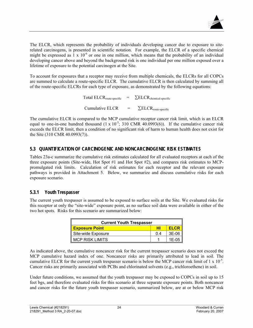
Lewis Chemical (#218291) 24 Woodard & Curran 218291_Method 3 RA_2-20-07.doc February 20, 2007
The ELCR, which represents the probability of individuals developing cancer due to exposure to site-related carcinogens, is presented in scientific notation. For example, the ELCR of a specific chemical might be expressed as 1 x 10⁻⁶ or one in one million, which means that the probability of an individual developing cancer above and beyond the background risk is one individual per one million exposed over a lifetime of exposure to the potential carcinogen at the Site. To account for exposures that a receptor may receive from multiple chemicals, the ELCRs for all COPCs are summed to calculate a route-specific ELCR. The cumulative ELCR is then calculated by summing all of the route-specific ELCRs for each type of exposure, as demonstrated by the following equations:
Total ELCRroute-specific = ∑ELCRchemical-specific
Cumulative ELCR = ∑ELCRroute-specific
The cumulative ELCR is compared to the MCP cumulative receptor cancer risk limit, which is an ELCR equal to one-in-one hundred thousand (1 x 10⁻⁵; 310 CMR 40.0993(6)). If the cumulative cancer risk exceeds the ELCR limit, then a condition of no significant risk of harm to human health does not exist for the Site (310 CMR 40.0993(7)).
5.3 QUANTIFICATION OF CARCINOGENIC AND NONCARCINOGENIC RISK ESTIMATES Tables 23a-c summarize the cumulative risk estimates calculated for all evaluated receptors at each of the three exposure points (Site-wide, Hot Spot #1 and Hot Spot #2), and compares risk estimates to MCP-promulgated risk limits. Calculation of risk estimates for each receptor and the relevant exposure pathways is provided in Attachment 5. Below, we summarize and discuss cumulative risks for each exposure scenario.
5.3.1 Youth Trespasser The current youth trespasser is assumed to be exposed to surface soils at the Site. We evaluated risks for this receptor at only the “site-wide” exposure point, as no surface soil data were available in either of the two hot spots. Risks for this scenario are summarized below:
Current Youth Trespasser Exposure Point HI ELCR Site-wide Exposure 0.4 3E-06 MCP RISK LIMITS 1 1E-05
As indicated above, the cumulative noncancer risk for the current trespasser scenario does not exceed the MCP cumulative hazard index of one. Noncancer risks are primarily attributed to lead in soil. The cumulative ELCR for the current youth trespasser scenario is below the MCP cancer risk limit of 1 x 10⁻⁵. Cancer risks are primarily associated with PCBs and chlorinated solvents (e.g., trichloroethene) in soil. Under future conditions, we assumed that the youth trespasser may be exposed to COPCs in soil up to 15 feet bgs, and therefore evaluated risks for this scenario at three separate exposure points. Both noncancer and cancer risks for the future youth trespasser scenario, summarized below, are at or below MCP risk
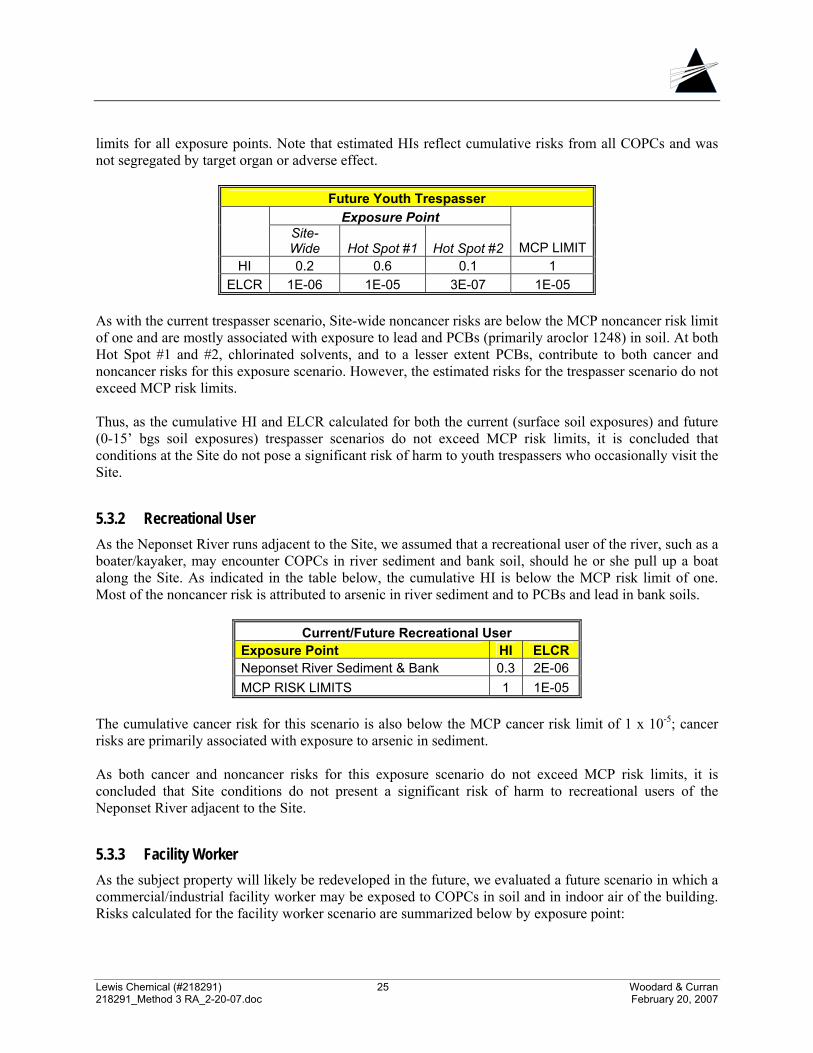
Lewis Chemical (#218291) 25 Woodard & Curran 218291_Method 3 RA_2-20-07.doc February 20, 2007
limits for all exposure points. Note that estimated HIs reflect cumulative risks from all COPCs and was not segregated by target organ or adverse effect.
Future Youth Trespasser Exposure Point
Site-Wide Hot Spot #1 Hot Spot #2 MCP LIMIT
HI 0.2 0.6 0.1 1 ELCR 1E-06 1E-05 3E-07 1E-05
As with the current trespasser scenario, Site-wide noncancer risks are below the MCP noncancer risk limit of one and are mostly associated with exposure to lead and PCBs (primarily aroclor 1248) in soil. At both Hot Spot #1 and #2, chlorinated solvents, and to a lesser extent PCBs, contribute to both cancer and noncancer risks for this exposure scenario. However, the estimated risks for the trespasser scenario do not exceed MCP risk limits. Thus, as the cumulative HI and ELCR calculated for both the current (surface soil exposures) and future (0-15’ bgs soil exposures) trespasser scenarios do not exceed MCP risk limits, it is concluded that conditions at the Site do not pose a significant risk of harm to youth trespassers who occasionally visit the Site.
5.3.2 Recreational User As the Neponset River runs adjacent to the Site, we assumed that a recreational user of the river, such as a boater/kayaker, may encounter COPCs in river sediment and bank soil, should he or she pull up a boat along the Site. As indicated in the table below, the cumulative HI is below the MCP risk limit of one. Most of the noncancer risk is attributed to arsenic in river sediment and to PCBs and lead in bank soils.
Current/Future Recreational User Exposure Point HI ELCR Neponset River Sediment & Bank 0.3 2E-06 MCP RISK LIMITS 1 1E-05
The cumulative cancer risk for this scenario is also below the MCP cancer risk limit of 1 x 10⁻⁵; cancer risks are primarily associated with exposure to arsenic in sediment. As both cancer and noncancer risks for this exposure scenario do not exceed MCP risk limits, it is concluded that Site conditions do not present a significant risk of harm to recreational users of the Neponset River adjacent to the Site.
5.3.3 Facility Worker As the subject property will likely be redeveloped in the future, we evaluated a future scenario in which a commercial/industrial facility worker may be exposed to COPCs in soil and in indoor air of the building. Risks calculated for the facility worker scenario are summarized below by exposure point:
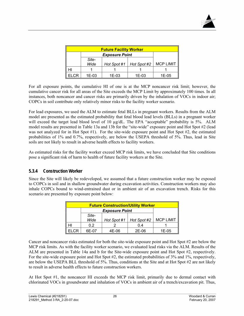
Lewis Chemical (#218291) 26 Woodard & Curran 218291_Method 3 RA_2-20-07.doc February 20, 2007
Future Facility Worker Exposure Point
Site-Wide Hot Spot #1 Hot Spot #2 MCP LIMIT
HI 1 1 1 1 ELCR 1E-03 1E-03 1E-03 1E-05
For all exposure points, the cumulative HI of one is at the MCP noncancer risk limit; however, the cumulative cancer risk for all areas of the Site exceeds the MCP Limit by approximately 100 times. In all instances, both noncancer and cancer risks are primarily driven by the inhalation of VOCs in indoor air; COPCs in soil contribute only relatively minor risks to the facility worker scenario. For lead exposures, we used the ALM to estimate fetal BLLs in pregnant workers. Results from the ALM model are presented as the estimated probability that fetal blood lead levels (BLLs) in a pregnant worker will exceed the target lead blood level of 10 µg/dL. The EPA “acceptable” probability is 5%. ALM model results are presented in Table 13a and 13b for the “site-wide” exposure point and Hot Spot #2 (lead was not analyzed for in Hot Spot #1). For the site-wide exposure point and Hot Spot #2, the estimated probabilities of 1% and 0.7%, respectively, are below the USEPA threshold of 5%. Thus, lead in Site soils are not likely to result in adverse health effects to facility workers. As estimated risks for the facility worker exceed MCP risk limits, we have concluded that Site conditions pose a significant risk of harm to health of future facility workers at the Site.
5.3.4 Construction Worker Since the Site will likely be redeveloped, we assumed that a future construction worker may be exposed to COPCs in soil and in shallow groundwater during excavation activities. Construction workers may also inhale COPCs bound to wind-entrained dust or in ambient air of an excavation trench. Risks for this scenario are presented by exposure point below:
Future Construction/Utility Worker Exposure Point
Site-Wide Hot Spot #1 Hot Spot #2 MCP LIMIT
HI 0.2 2 0.4 1 ELCR 6E-07 4E-06 2E-06 1E-05
Cancer and noncancer risks estimated for both the site-wide exposure point and Hot Spot #2 are below the MCP risk limits. As with the facility worker scenario, we evaluated lead risks via the ALM. Results of the ALM are presented in Table 14a and b for the Site-wide exposure point and Hot Spot #2, respectively. For the site-wide exposure point and Hot Spot #2, the estimated probabilities of 3% and 1%, respectively, are below the USEPA BLL threshold of 5%. Thus, conditions at the Site and at Hot Spot #2 are not likely to result in adverse health effects to future construction workers. At Hot Spot #1, the noncancer HI exceeds the MCP risk limit, primarily due to dermal contact with chlorinated VOCs in groundwater and inhalation of VOCs in ambient air of a trench/excavation pit. Thus,
Lewis Chemical (#218291) 27 Woodard & Curran 218291_Method 3 RA_2-20-07.doc February 20, 2007
the levels of COPCs present in groundwater at Hot Spot #2 present a significant risk of harm to future construction workers conducting excavation activities in this area of the Site.
5.3.5 Hypothetical Resident Since no deed restrictions beyond growing of produce have been contemplated at the Site, we assumed that the property may be converted in a residence; thus, future residents of the Site may be exposed to COPCs in soil and in indoor air. Additionally, we assumed that a resident will also use the river for recreational purposes and will therefore be exposed to COPCs in bank soil and in sediment. Risks for the residential scenario are summarized below.
Future Resident Exposure Point
Site-Wide Hot Spot #1 Hot Spot #2 MCP LIMIT
HI 18 28 16 1 ELCR 2E-02 2E-02 2E-02 1E-05
At all areas of the Site, both cumulative cancer and noncancer risks for the residential scenario are above the MCP risk limits. Most of the risk is driven by the inhalation of VOCs in indoor air. PCBs and heavy metals in soil also contribute to both cancer and noncancer risk. Childhood residential lead exposures were evaluated separately using the IEUBK lead model. Lead was detected in Hot Spot #2 and in the Site-wide exposure point, but not in Hot Spot #1. To streamline the evaluation, we ran the IEUBK model for only the Site-wide exposure point, in which lead concentrations were highest (261 mg/kg vs. 79 mg/kg in Hot Spot #2). IEUBK parameters and output are presented in Attachment 6. Results are expressed as a probability distribution indicating the percentage of children who are expected to exceed the target BLL of 10 µg/dL. This estimated probability of 2.4 % for the Site-wide exposure point is well below the EPA threshold probability of 5%. Thus, it is concluded that lead in Site soils will not likely result in a significant risk of harm to future Site residents. However, due to elevated concentrations of VOCs in soil gas and the presence of PCBs and heavy metals in soil, Site conditions pose a significant risk of harm to future Site residents in all exposure points at the Site.
5.4 COMPARISON TO APPLICABLE OR SUITABLY ANALOGOUS HEALTH STANDARDS The MCP requires that all applicable or suitably analogous health standards be identified and compared to exposure point concentrations in a Method 3 risk characterization (310 CMR 40.0993(3)). Such standards may include the following:
• Massachusetts Maximum Contaminant Levels (MMCLs), which are Massachusetts Drinking Water Standards (310 CMR 22.00);
• National Ambient Air Quality Standards (NAAQS), which are ambient air concentration limits listed at 40 CFR 50.00; and
• Massachusetts Surface Water Quality Standards (SWQS), specified in 310CMR 4.00.
Lewis Chemical (#218291) 28 Woodard & Curran 218291_Method 3 RA_2-20-07.doc February 20, 2007
Ambient air data are not available, but subsurface conditions are not expected to result in detectable ambient air concentrations at the Site. Therefore, we determined that NAAQS are not applicable to the Site.
Potentially applicable or suitably analogous standards include Massachusetts SWQS promulgated in 314 CMR 4.00. These standards are the USEPA National Recommended Water Quality Criteria (WQC; USEPA, 2002b), and include human-health based surface water quality standards that consider fish and/or water consumption. The nearest surface water body is the Neponset River. As surface water was ruled out as a medium of concern, however, WQC are not applicable to the Site.
The EPA residential lead hazard standard of 400 mg/kg in soil (40 CFR 745, Section 403 of the Toxic Substances Control Act) was also identified as a potentially applicable or suitably analogous health standard for the Site, since there are no deed restrictions at the Site that could restrict residential use of the property. However, the average concentrations of lead in both “site-wide” and Hot Spot #2 soils are below the EPA lead standard. (As previously discussed, lead was not detected/analyzed for in Hot Spot #1 soil.)
Lewis Chemical (#218291) 29 Woodard & Curran 218291_Method 3 RA_2-20-07.doc February 20, 2007
6. CHARACTERIZATION OF RISK TO SAFETY The risk of harm to safety is evaluated by comparing Site conditions to applicable or suitably analogous safety standards (310 CMR 40.0960(2)). For this Site, no applicable or suitably analogous safety standards were identified. The MCP in 310 CMR 40.0960 identifies several additional criteria that need to be considered in evaluation of safety, including:
• The presence of rusted or corroded drums or containers, open pits, lagoons or other dangerous structures (310 CMR 40.0960(3)(a)). None of these structures was observed on the Site.
• The threat of fire or explosion (310 CMR 40.0960(3)(b)). No conditions were identified at the
Site that would pose such a threat.
• Uncontained material that exhibits the characteristics of corrosivity, reactivity, or flammability as described in 310 CMR 40.0347. These materials have not observed at the Site.
Based upon the above evaluation, a condition of no significant risk of harm to safety exists at the Site, as no threat of physical harm or bodily injury to people related to the COPCs was observed at the Site or within the surrounding area (310 CMR 40.0960).
Lewis Chemical (#218291) 30 Woodard & Curran 218291_Method 3 RA_2-20-07.doc February 20, 2007
7. CHARACTERIZATION OF RISK TO PUBLIC WELFARE The characterization of risk to public welfare includes a qualitative assessment of whether the Site may adversely impact the neighboring community. Conditions at the Site are evaluated below with respect to each of these potential public welfare impacts:
• Nuisance conditions will not arise from Site activities or remedial activities; these conditions include the existence of noxious taste and/or odors in indoor air, ambient air or an accessible drinking water source;
• A condition of no significant risk of harm to the health of livestock is present at the Site; and
• Current and reasonably foreseeable communities affected by the Site releases will not experience
nuisance conditions, loss of active or passive property use, and any non-pecuniary effects. Nuisance conditions such as odors are not present at the Site, and groundwater is not a potential drinking water source. Livestock are not currently present at the Site nor, due to the Site’s developed location, are they expected to be present in the future. It is not anticipated that the surrounding community will experience nuisance conditions, loss of property uses, or other non-pecuniary effects as a result of Site releases. The characterization of risk to public welfare also includes a comparison of the concentrations of COPCs to Upper Concentration Limits (UCLs; 310 CMR 40.0994). UCLs are threshold concentrations that, if exceeded, indicate the potential for significant risk of harm to public welfare and the environment under future conditions. Table 24a and 24b present a comparison of mean soil and groundwater concentrations, respectively, at each of the three exposure points (HS#1, HS#2 and Site-wide) to UCLs, in accordance with the MCP (310 CMR 40.0996(2)(a)). Mean soil concentrations of each COPC in soil at all exposure points are below the applicable UCLs. In groundwater, the mean concentrations of trichloroethene in Hot Spot #1 and C19-C36 aliphatics in Hot Spot #2 exceed their respective UCLs. Thus, a condition of no significant risk to the public welfare has not been achieved at the Site.
Lewis Chemical (#218291) 31 Woodard & Curran 218291_Method 3 RA_2-20-07.doc February 20, 2007
8. CHARACTERIZATION OF RISK TO THE ENVIRONMENT This section addresses the potential risk of harm to the environment for the Site in accordance with MADEP guidance (MADEP 1996). Under the MCP, a two-stage approach is used to determine if chemicals originating at a Site are present in concentrations that pose a significant risk of harm to habitats and biota (310 CMR 40.0995(3)). The Stage I Environmental Screening (ES) first identifies complete exposure pathways, where chemicals of potential concern could reach identified ecological receptors. For all complete exposure pathways, chemical concentrations are compared to effects-based benchmark values. If chemical concentrations are below benchmark values, a condition of “no significant risk of harm to habitats and biota” is assumed to exist. In a Stage I ES, the habitat quality in the area of the Site is first evaluated to determine whether terrestrial or aquatic habitats may be affected currently or in the foreseeable future by chemicals found in soil and groundwater at the Site. This evaluation includes a physical and biological description of the Site, identification of impacted environmental media, and the identification of complete exposure pathways. For this Site, a Stage I ES was conducted.
8.1 HABITAT DESCRIPTION The habitat assessment considers the characteristics of the site that influence exposure to terrestrial and aquatic wildlife, and is based on information obtained from a site visit completed by W&C personnel and from previous site investigations. Additionally, information regarding natural resource areas at or within 500 feet of the Site is based on a review of the USGS Topographic Map, the Massachusetts Natural Heritage Atlas, 2006 on-line edition, and the 2006 MassGIS on-line mapping system for the area. The Site is located in a mixed residential/commercial/industrial setting and consists primarily of the former Lewis Chemical facility, partially paved areas, areas of debris and vegetated areas. The Site also includes the banks and sediment of the Neponset River. Upland areas of the Site provide limited, low-quality habitat for various species, including songbirds, waterfowl, rodents, raccoons, squirrels and other species typically present in suburban/urban areas. The Neponset River and banks, however, provide suitable habitat for many aquatic, semi-aquatic and terrestrial receptors, serving as a wildlife corridor throughout an urban area. According to MassGIS (2006), the Neponset River and banks are designated as Protected Open Space. Approximately two miles downstream of the Site, the lower Neponset River is a designated Area of Critical Environmental Concern (ACEC). No Natural Heritage and Endangered Species Program (NHESP) Priority Habitat of Rare Species/Estimated Habitat of Rare Wildlife or other sensitive resource areas, such as vernal pools, are present at or near the Site. Upland areas of the Site comprise approximately one-half acre, and much of the Site is developed. Based on existing and reasonably foreseeable conditions at the Site, it is concluded that a complete terrestrial exposure pathway does not exist. In accordance with MADEP guidance (1996), Site conditions in upland areas do not warrant further evaluation for terrestrial receptors. As previously discussed, VOCs and heavy metals (arsenic and selenium) have been detected in sediment samples collected from the river at concentrations elevated above local conditions7. Receptors that have
7 As discussed, PCBs in river sediment will be evaluated once additional USGS data are made publicly available.
Lewis Chemical (#218291) 32 Woodard & Curran 218291_Method 3 RA_2-20-07.doc February 20, 2007
the most direct exposure potential to COPCs in sediment are the benthic invertebrates (or benthos) that live in close contact with the sediment. Typical aquatic invertebrates that likely dominate the substrate in the Neponset River may include species such as dragonflies, mayflies, stoneflies, and crayfish. Exposure to sediment contaminants has the potential to cause adverse toxic effects to these receptors and alter community structure, and may reduce the abundance, diversity, and biomass of organisms. Benthic invertebrates participate in processes, such as nutrient cycling, essential to a healthy ecosystem. In addition, benthic invertebrates comprise an important prey base for higher trophic level species, including fish, waterfowl, some small mammals, and wading predatory birds. Fish and wildlife that feed on benthic organisms may be affected by sediment contaminants indirectly via a reduction of the benthic prey base, or directly via incidental ingestion of contaminated sediments and food organisms that have incorporated COPCs into their tissues. Metals are known bioaccumulative constituents. VOCs, which are relatively water-soluble, are not anticipated to significantly bioaccumulate in wildlife.
8.2 STAGE I SCREENING To evaluate potential effects to aquatic/benthic organisms under current conditions, W&C conducted a Stage I screening level evaluation by comparing sediment concentrations of COPCs at the Site to freshwater sediment benchmarks protective of ecological receptors. For sediment exposures, we compared the maximum detected concentration of each COPC in site sediment to the MADEP Stage I sediment screening benchmark (MADEP, 2006). Sediment screening benchmarks (used to evaluate effects to benthic communities) are concentrations associated with the probability of an adverse ecological effect, and are derived from a large number of field and laboratory studies. For arsenic, the Stage I benchmark is the Probable Effects Concentration (PEC; MacDonald et al., 2000). The PECs are consensus-based benchmarks derived from several sediment quality guidelines and represent a probable-effects threshold concentration above which effects on benthic organisms are expected to frequently occur (MacDonald et al., 2000). MADEP has not issued Stage I screening benchmarks for VOCs or for selenium. For these constituents, we evaluated potential ecological effects through comparison of sediment concentrations to various state/federal sediment benchmarks as provided in the Oak Ridge National Laboratory (ORNL) Risk Assessment Information System (RAIS). Table 25 summarizes the Stage I quantitative comparison of sediment concentrations to ecological benchmarks for sediment. As shown in this table, concentrations of selenium and many of the VOCs exceed the screening benchmarks. While this result does not mean that adverse ecological effects are expected, it does signify that the potential for significant ecological risk exists and that further evaluation is necessary.
8.3 UPPER CONCENTRATION LIMITS As part of a Method 3 environmental risk characterization, Site concentrations are compared to MCP Upper Concentration Limits (UCLs). The arithmetic mean soil concentration and mean groundwater concentration (based on temporal wellhead averages, 2002-2006) at each exposure point are compared to soil and groundwater UCLs in Table 24a and 24b, respectively. Mean soil concentrations of each COPC are below the applicable UCLs; however, C19-C36 aliphatics and trichloroethene in groundwater exceed the UCLs. Thus, a condition of No Significant Risk of Harm to the Environment does not exist under future conditions.
Lewis Chemical (#218291) 33 Woodard & Curran 218291_Method 3 RA_2-20-07.doc February 20, 2007
8.4 CONCLUSIONS OF THE ENVIRONMENTAL RISK CHARACTERIZATION A Stage I environmental risk characterization was conducted for the Site. Terrestrial exposure pathways were ruled out as incomplete due to the developed nature of the Site and the small area of impact. Wildlife may be exposed to COPCs in sediment of the Neponset River, which provides high quality habitat for a variety of organisms. Readily apparent harm is not evident at the Site, as indicated by the following criteria presented in 310 CMR 40.0995(3)(b)(1):
o There is no visual evidence of stressed biota attributable to Site releases, such as fish kills or abiotic conditions;
o No COPCs were detected in surface water samples collected from the river at concentrations above Massachusetts Surface Water Standards (i.e., federal WQC); and
o Oil, tar or other non-aqueous phase liquid is not present in soil, groundwater or sediment. However, the results of the Stage I screening level comparison indicate that concentrations of VOCs and selenium exceed sediment benchmarks protective of ecological receptors, indicating that sediment COPCs may present a potential risk of harm to the environment at the levels present in the river adjacent to the Site. Additionally, concentrations of C19-C36 aliphatics and trichloroethene in groundwater exceed UCLs. Therefore, it is concluded that a condition of No Significant Risk of harm to the environment has not been achieved at the Site under current or reasonably foreseeable future conditions. Additional evaluation of potential ecological effects, through a comprehensive Stage II ERC, is warranted to determine whether Site conditions present a significant risk of harm to ecological receptors.
Lewis Chemical (#218291) 34 Woodard & Curran 218291_Method 3 RA_2-20-07.doc February 20, 2007
9. UNCERTAINTY ANALYSIS As part of a Method 3 risk characterization, information is presented on the uncertainty associated with the risk characterization, including data gaps in toxicological or exposure assessment information and the conservative assumptions or scientific judgments used to bridge these data gaps. Numerical estimates of risk to human health, public welfare, safety, and the environment presented in this report are only as good as the data and information upon which they are based. A discussion of the uncertainty and conservatism associated with this risk characterization is provided in this section to facilitate an understanding of the strengths and limitations of the Method 3 risk characterization for this Site. Below, W&C highlights some of the potential sources of uncertainty and the likely direction of their effect.
9.1 HAZARD IDENTIFICATION In general, uncertainties associated with hazard identification include the methodologies used to collect the samples, the analyses conducted on samples collected, the overall number of samples that are collected, and the available data. Numerous soil samples were collected from across the Site and provide an adequate representation of average Site conditions. Only two rounds of groundwater data have been collected to date, however, and thus the data may not fully reflect seasonal/temporal changes. In this risk characterization, we have countered some of this uncertainty by utilizing groundwater data collected over these sampling rounds and by incorporating conservative assumptions into the exposure assessment and risk characterization when possible. PCB data are not currently available for river sediments located adjacent to the Site. This lack of data represents a data gap in the risk characterization and may potentially underestimate risk. As previously discussed, USGS has collected additional sediment and surface water data indicating that PCBs are present throughout the Neponset River as a result of releases from L.E. Mason and other disposal sites upstream of the Site. It is recommended that when additional data are available, these data are reviewed relative to local conditions to evaluate whether the former Lewis Chemical Site has contributed to PCB contamination in the river. If so, these data would be incorporated into the risk characterization in order to evaluate the extent of PCBs in river sediment relative to the Site and local conditions and, if warranted, to characterize potential risks associated with human and ecological exposure.
9.2 EXPOSURE ASSESSMENT In general, estimation of EPCs (including calculation of arithmetic mean concentrations and derivation of EPCs based on exposure models), characterization of current and reasonably foreseeable Site activities and uses, and calculation of daily doses contribute most to the uncertainty in the exposure assessment component of the risk characterization. To counter this uncertainty, health-protective exposure assumptions based on either Site-specific information or conservative default values provided in MADEP or USEPA guidance were used to quantitatively evaluate potential risks posed by the Site. Specific examples of uncertainty in the exposure assessment include the following:
• Both the IEUBK and ALM models used to estimate blood lead levels (in children and construction workers, respectively) take into account background levels of lead attributable to non-site sources (such as diet, air, water, etc.) and therefore likely overpredicts site-related lead risks.
Lewis Chemical (#218291) 35 Woodard & Curran 218291_Method 3 RA_2-20-07.doc February 20, 2007
• For soil exposures, the average concentration of each COPC was generally used (with the
exception of Hot Spot #1, for which only one sample was available) to evaluate potential Site-related risks. Although in some instances use of the average may potentially underestimate risk, it is more likely that the mean concentration represents a conservative estimate of average Site conditions, as much of the sampling was biased toward areas of the highest contamination, and future receptors are likely to have a more widespread exposure to site soils. To counter some of this uncertainty, we included one-half the detection limit for results reported as non-detect.
• When evaluating fugitive dust exposures, we assumed that Site soils would not be covered by
vegetation. For the future scenarios, in particular, this may be a conservative assumption, as the developed property is likely to be paved and/or landscaped.
• For the trespasser and recreational user scenario, we assumed that these receptors would be
exposed to impacted media at the Site on a routine, weekly basis over their entire thirteen-year exposure duration. For such exposure scenarios, there is considerable uncertainty in predicting a trespasser’s or recreator’s exposure at a Site. In all likelihood, we have overestimated actual exposure to Site media for these receptors.
In general, we used a mixture of conservative and mid-range exposure assumptions in order to derive realistic, yet protective, estimates of exposure.
9.3 DOSE-RESPONSE ASSESSMENT The primary sources of uncertainty associated with the toxicity values used to quantify risks include: (1) extrapolation of dose-response information from effects observed at high doses to predict adverse effects at low levels anticipated for human exposure to environmental contaminants, (2) use of toxicity information compiled from short-term exposure studies to predict the effects associated with long-term exposures (and vice-versa), (3) use of dose-response information from animal studies to predict likely effects in humans, and (4) use of toxicity information based on homogeneous animal populations or healthy human populations to predict the effects that are likely to be observed in the general population (including sensitive subgroups). Human variability in response to chemical exposures may be dependent on a number of factors, and risks estimated for one population may not necessarily be protective or indicative of risks in a different population. The dose-response values used in the calculation of HIs and cancer risk estimates are conservative values. Since RfDs and RfCs are derived using a number of safety factors and are developed to protect sensitive populations, the actual dose or concentration associated with a health effect is likely to be higher than the dose or concentration established by USEPA or the MADEP for most groups in the general population. To be conservative, when no subchronic dose-response value was available, the chronic value was used. Oral toxicity values were converted to dermal toxicity values for several COPCs (primarily metals) where information about dermal absorption was available. For other compounds, we have used the oral toxicity values to evaluate dermal risks. Use of oral values may potentially over- or underestimate potential risks via dermal exposure routes. However, it is standard practice to use values derived from studies based on oral exposures to evaluate dermal contact exposures. This technique is generally health-protective since it has been demonstrated that the most significant exposures for most chemicals or COPCs occur via the oral and inhalation route.
Lewis Chemical (#218291) 36 Woodard & Curran 218291_Method 3 RA_2-20-07.doc February 20, 2007
For some compounds lacking toxicity data, we utilized noncancer toxicity values from surrogate compounds with similar chemical structure. For example, pyrene is used as a surrogate compound for the C11-C22 aliphatic hydrocarbon range. Use of surrogate compounds may potentially over or underestimate risks associated with these compounds. Cancer is typically associated with a life-long, extended exposure. Recent data suggest, however, that early-life exposures in children may result in early cancer progression or an enhanced rate of cancer in adulthood (USEPA, 2005b). Children are often more sensitive than adults to both carcinogenic and noncarcinogenic compounds, and for mutagenic (DNA-altering) compounds, in particular, early life exposures to such compounds may exhibit a greater cancer effect than would later-life exposures (USEPA, 2005b). For carcinogens that are known to have a mutagenic mode of action, such as vinyl chloride, an Age-Dependent Adjustment Factor (ADAF) is applied to early-life exposures (USEPA, 2005b). The ADAF accounts for susceptibility differences between early and later-life exposures, and is applied to the CSF or inhalation UR. The USEPA IRIS cancer values for vinyl chloride, a known mutagen, include an ADAF. For compounds in which the mode of action is unknown, however, cancer risks may be underestimated for childhood receptors.
9.4 HUMAN HEALTH RISK CHARACTERIZATION Sources of uncertainty in the risk characterization section include the equal weight given to chemical constituents whose RfDs have different confidence levels in estimating noncarcinogenic HIs and the assumption of simple additivity of ELCRs and HIs across COPCs. In general, conservative parameters were used whenever possible or recommended by MADEP or USEPA guidance. By using this conservative approach in developing risk estimates, it would be expected that the calculated risk estimates are likely to result in upper bound estimates of actual Site-related hazards. Consequently, these estimates should be used to highlight areas of potential concern and to assist in providing practical risk management information, rather than be considered as absolute estimates of health risks.
9.5 SAFETY, PUBLIC WELFARE AND THE ENVIRONMENT There is little uncertainty regarding risks to safety and public welfare. Safety hazards attributable to the Disposal Site are not evident and are unlikely to be present based on the nature of the release. Conditions at the Site will not detracted from the Site’s use, nor have Site conditions adversely impacted conditions in the surrounding community. Sediment data from the Neponset River indicate that concentrations of VOCs and selenium are elevated with respect to local conditions and Stage I ecological screening criteria. Although readily apparent harm to the environmental is not evident at the Site, the Stage I ERC results indicate that further evaluation of ecological effects is warranted. Woodard & Curran recommends that future assessment at the Site includes a comprehensive Stage II ERC.
Lewis Chemical (#218291) 37 Woodard & Curran 218291_Method 3 RA_2-20-07.doc February 20, 2007
10. CONCLUSIONS A Method 3 risk characterization was completed for the disposal site located at 0 & 12-24 Fairmount Court in Hyde Park, Massachusetts. Results of the human health, safety, public welfare, and environmental risk characterizations are summarized below.
10.1 HUMAN HEALTH The MCP indicates that a condition of No Significant Risk of harm to human health exists or has been achieved if:
• No Cumulative Receptor Cancer Risk calculated is greater than the Cumulative Cancer Risk Limit of 1 x 10⁻⁵;
• No Cumulative Receptor Noncancer Risk is greater than the Cumulative Receptor Noncancer Risk
Limit of 1.0; and
• No Exposure Point Concentration of OHM is greater than an applicable or suitably analogous public health standard.
Cumulative receptor noncancer risks were compared to one (1), the MCP Cumulative Noncancer Risk Limit. The cumulative receptor cancer risks were compared to the MCP Cumulative Cancer Risk Limit, which is an ELCR equal to one in one hundred thousand (1 x 10⁻⁵). Risks estimated for the trespasser and recreational scenarios do not exceed MCP risk limits. Both cumulative cancer and noncancer risks for the construction worker, facility worker and future resident scenarios, however, exceed MCP risk limits. Therefore, a condition of No Significant Risk (NSR) of harm to human health has NOT been achieved for the Site.
10.2 SAFETY, PUBLIC WELFARE AND ENVIRONMENTAL RISK CHARACTERIZATION Based on observations made and information collected during environmental investigations of the Site, conditions at the Site do not pose a threat of physical harm or bodily injury to people. Furthermore, W&C did not identify release-related conditions that may pose a risk to public safety. Therefore, a condition of No Significant Risk of harm to safety has been achieved at the Site. There are no identifiable adverse impacts to the surrounding community from the site. However, one of the public welfare criteria involves a comparison of analytical data to Upper Concentrations Limits. Groundwater concentrations of trichloroethene at Hot Spot #1 and C19-C36 aliphatics at Hot Spot #2 exceed their Upper Concentration Limits. Therefore, in accordance with the MCP at 310 CMR 40.0996(3), a condition of No Significant Risk to Public Welfare has NOT been achieved at the Site. This condition is specifically attributed to the technical exceedance of trichloroethene and C19-C36 aliphatics UCLs in groundwater alone. As the Site is developed and less than one acre in size, there are currently no complete exposure pathways on Site for terrestrial receptors. No observations of readily apparent harm to the environment have been made at the Site; however, sediment concentrations of selenium and VOCs exceed ecological screening benchmarks used in a Stage I Ecological Screening. Therefore, a condition of No Significant Risk of harm

Lewis Chemical (#218291) 38 Woodard & Curran 218291_Method 3 RA_2-20-07.doc February 20, 2007
to the environment has NOT been achieved at the Site for current and reasonably foreseeable future conditions.
Lewis Chemical (#218291) 39 Woodard & Curran 218291_Method 3 RA_2-20-07.doc February 20, 2007
11. REFERENCES
American Academy of Pediatrics (AAP). 1998. Policy Statement: Screening for Elevated Blood Lead
Levels (RE 9815). Pediatrics, 101: 1072-1078. Breault, R.F., Cooke, M. G., and Merrill, M. 2004. Data on Sediment Quality and Concentrations of
Polychorinated Biphenyls from the Lower Neponset River, Massachusetts, 2002-2003. U.S. Geological Survey Open File Report 2004-1280, 55p.
IT Group, January 24, 2001. 120-Day IRA Status Report, L.E. Mason Company, 98 Business Street,
Boston, MA. IT Group, April 26, 2002. Immediate Response Action Completion Report Mother Brook, L.E. Mason
Company. MacDonald, D.D., Ingersoll, C.G., and Berger, T.A. 2000. Development and Evaluation of Consensus-
Based Sediment Quality Guidelines for Freshwater Ecosystems. Arch. Environ. Contam. Toxicol. 39, 200-31.
Massachusetts Department of Environmental Protection (MADEP). 2002a. Background Levels of
Polycyclic Aromatic Hydrocarbons and Metals in Soil. Bureau of Waste Site Cleanup, Boston, MA. May 23, 2002.
Massachusetts Department of Environmental Protection (MADEP) 2002b. Draft Supplemental Guidance:
Weighted Skin-Soil Adherence Factors. Office of Research and Standards, Boston, Massachusetts. February, 2002.
Massachusetts Department of Environmental Protection (MADEP). 2002c. Technical Update: Enhanced
Soil Ingestion Rates. Office of Research and Standards, Boston, Massachusetts. February, 2002. Massachusetts Department of Environmental Protection (MADEP) 2002d. Draft Technical Update:
Characterization of Risks due to Inhalation of Particulates by Construction Workers. Boston, Massachusetts.
Massachusetts Department of Environmental Protection (MADEP) 2006. Technical Update: Revised
Sediment Screening Values. Office of Research and Standards, Boston, MA. January 2006. Massachusetts Department of Environmental Protection (MADEP) 2007. Development of MCP Risk-
Based Levels for Soil and Groundwater (provided as downloadable Excel spreadsheets through the MADEP website (http://www.state.ma.us/dep/bwsc). ‘Toxicity.xls’ (chemical/toxicological information) and ‘MCP GW2 alpha.xls’ (Vapor Intrusion model)
Massachusetts Department of Environmental Protection (MADEP). 1996. Guidance for Disposal Risk
Characterization, Method 3 - Environmental Risk Characterization, Interim Final Policy, Bureau of Waste Site Cleanup and Office of Research and Standards. Boston, MA.
Lewis Chemical (#218291) 40 Woodard & Curran 218291_Method 3 RA_2-20-07.doc February 20, 2007
Massachusetts Department of Environmental Protection (MADEP). 1995. Guidance for Disposal Site Risk Characterization - In Support of the Massachusetts Contingency Plan, Interim Final Policy. WSC/ORS 95-141. July, 1995. Bureau of Waste Site Cleanup. Boston, Massachusetts.
Massachusetts Department of Environmental Protection (MADEP). 1992. Documentation for the Risk
Assessment Shortform, Residential Scenario. October, 1992. Bureau of Waste Site Cleanup and Office of Research and Standards. Boston, MA.
Shaw, June 30, 2005. Notice of Intent, Phase IV – Remedy Implementation Plan Regulatory Permitting
Support Document. Shaw, December, 2004. Phase II/III Comprehensive Site Assessment and Remedial Action Plan
Addendum. United States Environmental Protection Agency (USEPA). 2007. Integrated Risk Information System
(IRIS). On-line database. Office of Emergency and Remedial Response: Washington, D.C. United States Environmental Protection Agency (USEPA). 2005a. Guidelines for Carcinogen
Risk Assessment. Risk Assessment Forum, March 2005. EPA/630/P-03/001F United States Environmental Protection Agency (USEPA). 2005b. Supplemental Guidance for Assessing
Susceptibility from Early-Life Exposure to Carcinogens. Risk Assessment Forum, Washington D.C. (EPA/630/R-03/003F)
United States Environmental Protection Agency (USEPA). 2004. Risk Assessment Guidance for
Superfund, Part E. Supplemental Guidance for Dermal Risk Assessment, Final. EPA/540/R/99/05, July 2004.
United States Environmental Protection Agency (USEPA). 2002. Guidance for Comparing Background
and Chemical Concentrations in Soil for CERCLA Sites; September. United States Environmental Protection Agency (USEPA). 2002a. Blood Lead Concentrations in U.S.
Adult Females: Summary Statistics from Phases I and II of the National Health and Nutrition Evaluation Survey (NHANES III). EPA OSWER #9285.7-52 March 2002
United States Environmental Protection Agency (USEPA). 2002b. National Recommended Water
Quality Criteria: 2002, Office of Water/Office of Science and Technology. EPA-822-R-02-047. [Updates through December 2004]
United States Environmental Protection Agency (USEPA). 1999. Exposure Factors Handbook. Office
of Health and Environmental Assessment. Washington, D.C. (EPA/600/C-99/001). United States Environmental Protection Agency (USEPA). 1997. Health Effects Assessment Summary
Tables (HEAST). Office of Emergency and Remedial Response: Washington, D.C. United States Environmental Protection Agency (USEPA). 1996. Recommendations of the Technical
Review Workgroup for Lead for an Interim Approach to Assessing Risks Associated with Adult Exposures to Lead in Soil. Technical Review Workgroup for Lead, December.
Lewis Chemical (#218291) 41 Woodard & Curran 218291_Method 3 RA_2-20-07.doc February 20, 2007
United States Environmental Protection Agency (USEPA). 1994. Guidance Manual for the Integrated
Exposure Uptake Biokinetic Model for Lead in Children. Office of Emergency and Remedial Response: Washington, D.C. (EPA 540-R-93-081)
United States Environmental Protection Agency, Region 1 (USEPA-R1). 1994. Risk Updates. No. 2,
August, 1994. USEPA Region 1, Boston, MA. United States Environmental Protection Agency (USEPA). 1990. Estimation of Baseline Air Emissions
at Superfund Sites. Report ASF-2a. Office of Air Quality. August. United States Environmental Protection Agency (USEPA). 1989. Risk Assessment Guidance for
Superfund: Volume I Human Health Evaluation and Volume II Environmental Evaluation Manual.

Lewis Chemical (#218291) Woodard & Curran 218291_Method 3 RA_2-20-07.doc February 20, 2007
TABLES