Embed Size (px)
Citation preview
Today’s open house provides you with information on the Metro Line NW LRT project, and your opportunity to help us plan for LRT and the future of your community.
Stay engaged!For more information on upcoming events, please call 311 or visit edmonton.ca/metronw
Metro Line Northwest LRT Expansion Project
Welcome
153 AVENUE153 AVENUE 137 STREET137 STREET
127 STREET127 STREET
CASTLE DOWNSCASTLE DOWNS
145 AVENUE145 AVENUE
137 AVENUE137 AVENUE
132 AVENUE132 AVENUE
BLATCHFORDBLATCHFORD
NAITNAIT
CHURCHILLCHURCHILL
Kingsway
Kingsway
111 Ave NW111 Ave NW
124 St NW
124 St NW
104 Ave NW104 Ave NW
Jasper AveJasper Ave
107 Ave NW107 Ave NW
97 St NW
97 St NW
Princess Eliza
beth
Ave NW
Princess Eliza
beth
Ave NW
101 St NW
101 St NW
Yellowhead TrailYellowhead Trail
118 Ave NW118 Ave NW
St. Albert Trail NW
St. Albert Trail NW
Groat Rd N
WG
roat Rd NW
127 St NW
127 St NW
Stony Plain Rd NW
Stony Plain Rd NW
Yellowhead TrailYellowhead Trail
137 Ave NW137 Ave NW
127 St NW
127 St NW
97 St NW
97 St NW
153 Ave NW153 Ave NW
82 St NW
82 St NW
137 Ave NW137 Ave NW
82 St NW
82 St NW
118 Ave NW118 Ave NW
111 Ave NW111 Ave NW
112 Ave NW112 Ave NW
Rossdal
e RD N
W
Rossdal
e RD N
W
Scon
a RD
NW
Scon
a RD
NW
105 St NW
105 St NW
109 St NW
109 St NW
113a St NW
113a St NW
MACEWANMACEWAN
KINGSWAY/ ROYALALEXANDRA HOSPITALKINGSWAY/ ROYALALEXANDRA HOSPITAL
127 Ave NW127 Ave NW 127 Ave NW127 Ave NW
142 St NW
142 St NW
Campbell Rd NW
Campbell Rd NW
BLATCHFORDBLATCHFORD
Future St. AlbertPark and Ride
Future St. AlbertPark and Ride
DOWNTOWNDOWNTOWN
QUEEN MARYPARK
QUEEN MARYPARK
OLIVEROLIVER
WESTMOUNTWESTMOUNT
INGLEWOODINGLEWOOD
PRINCE CHARLESPRINCE CHARLES
SPRUCEAVENUESPRUCEAVENUE
ALBERTAAVENUEALBERTAAVENUE
RIVERDALERIVERDALE
ROSSDALEROSSDALE
DELTONDELTON
MCCAULEYMCCAULEY
BOYLE STREETBOYLE STREET
CALDERCALDER LAUDERDALELAUDERDALE
KENSINGTONKENSINGTON ROSSLYNROSSLYN
GRIESBACHGRIESBACHCARLISLECARLISLE
BARANOWBARANOW
CAERNARVONCAERNARVON
BEAUMARISBEAUMARIS
DUNLUCEDUNLUCEOXFORDOXFORD
CARLTONCARLTON
CUMBERLANDCUMBERLAND
HUDSONHUDSON
ATHLONEATHLONE
PEMBINAPEMBINA
KILLARNEYKILLARNEY
GLENGARRYGLENGARRY
NORTHMOUNTNORTHMOUNT
EVANSDALEEVANSDALE
EAUX CLAIRESEAUX CLAIRES
WELLINGTONWELLINGTON
CENTRALMCDOUGALL
CENTRALMCDOUGALL
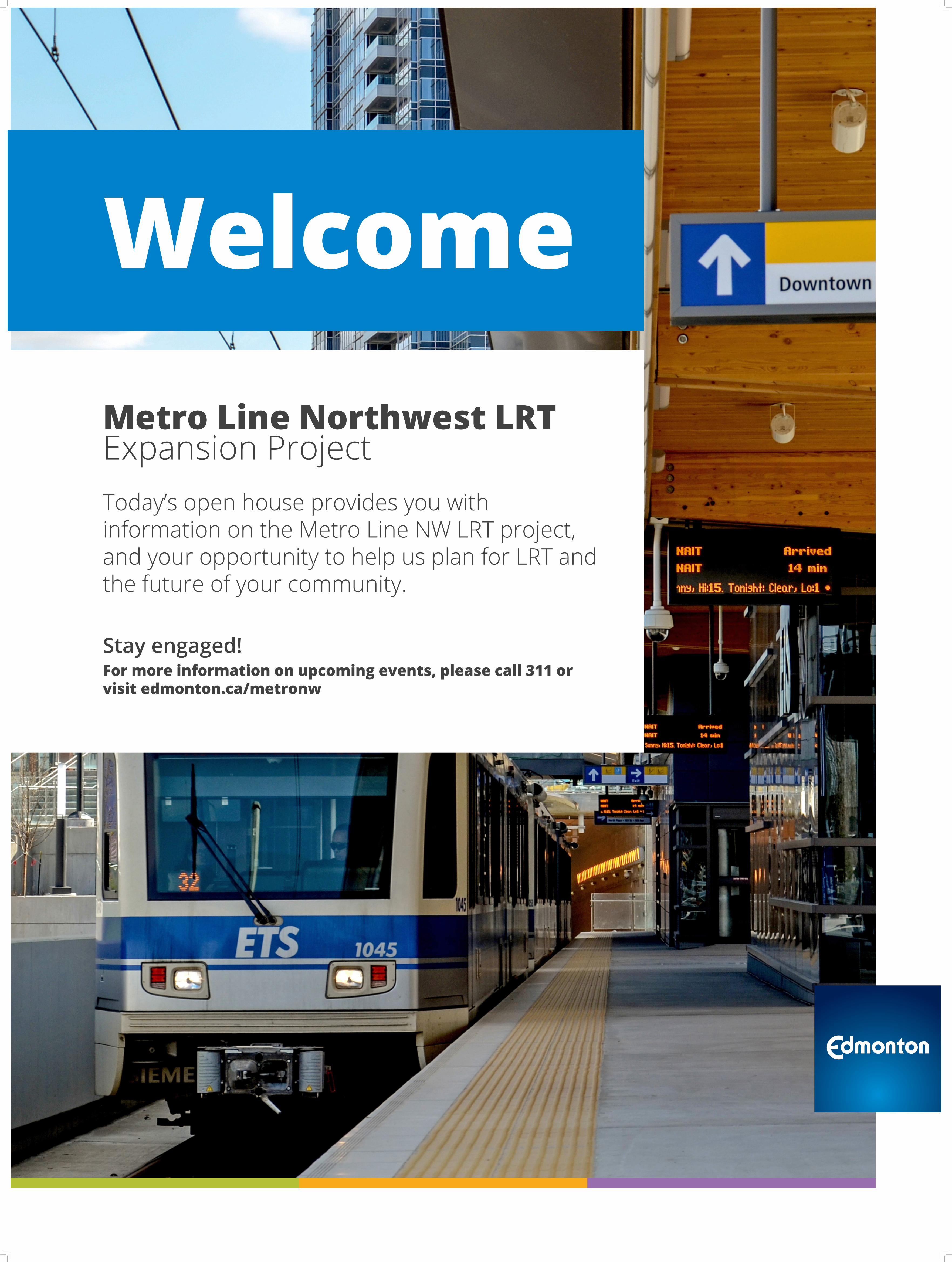
Please tell us where you live
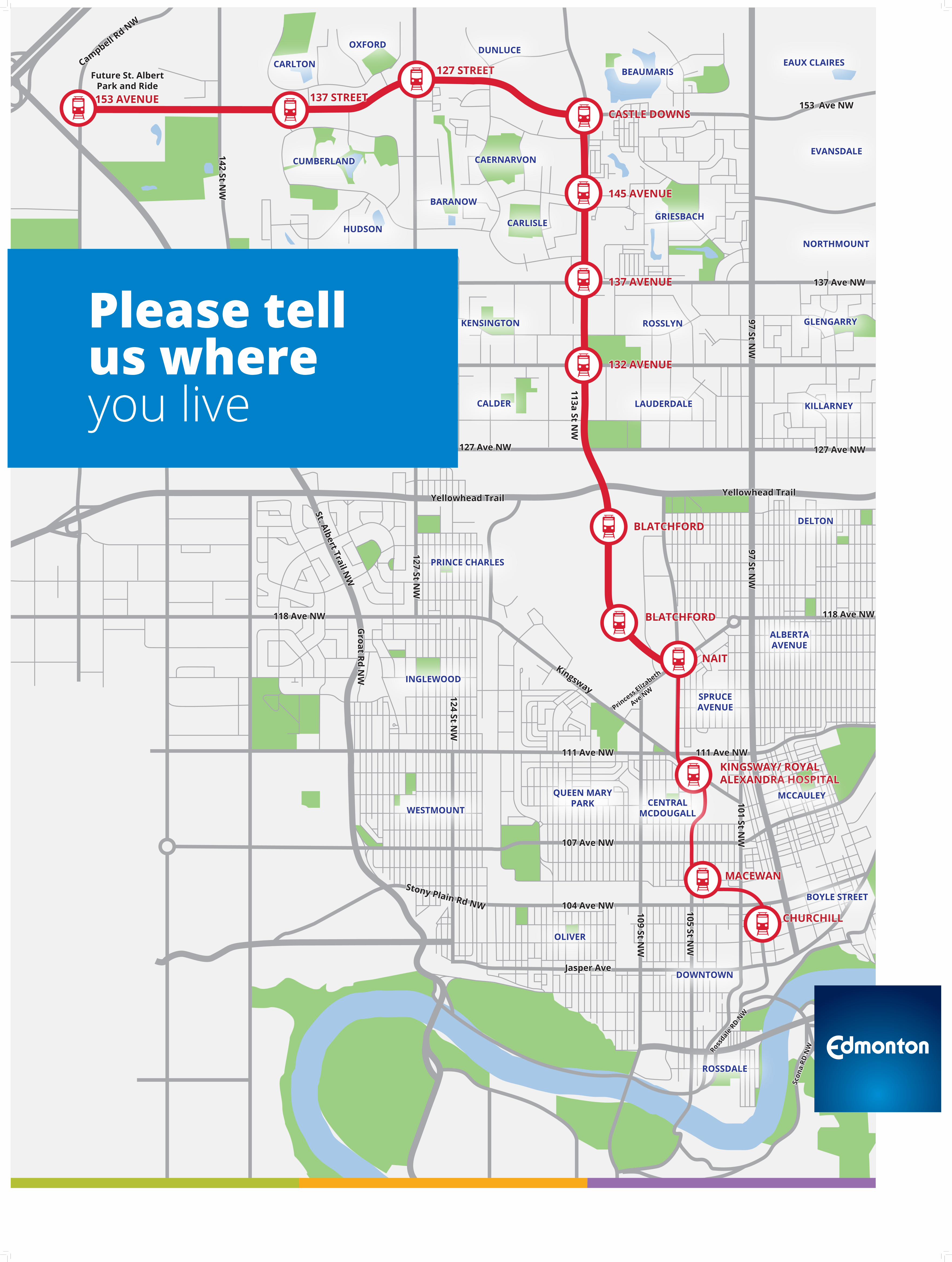
The City of Edmonton’s Public Engagement Framework is part of the City’s overall commitment to open government – Edmonton as an Open City.
Through the public engagement spectrum, there are four roles the public can play when they participate in the City’s public engagement activities.
Public input into the Metro Line NW LRT at this stage of planning focuses on Advise and Refine. We are looking for your feedback in the following areas:
• Final track alignment • Side or centre running track• Community connections to stations • Potential construction concerns
Share Your VoiceShape Our City
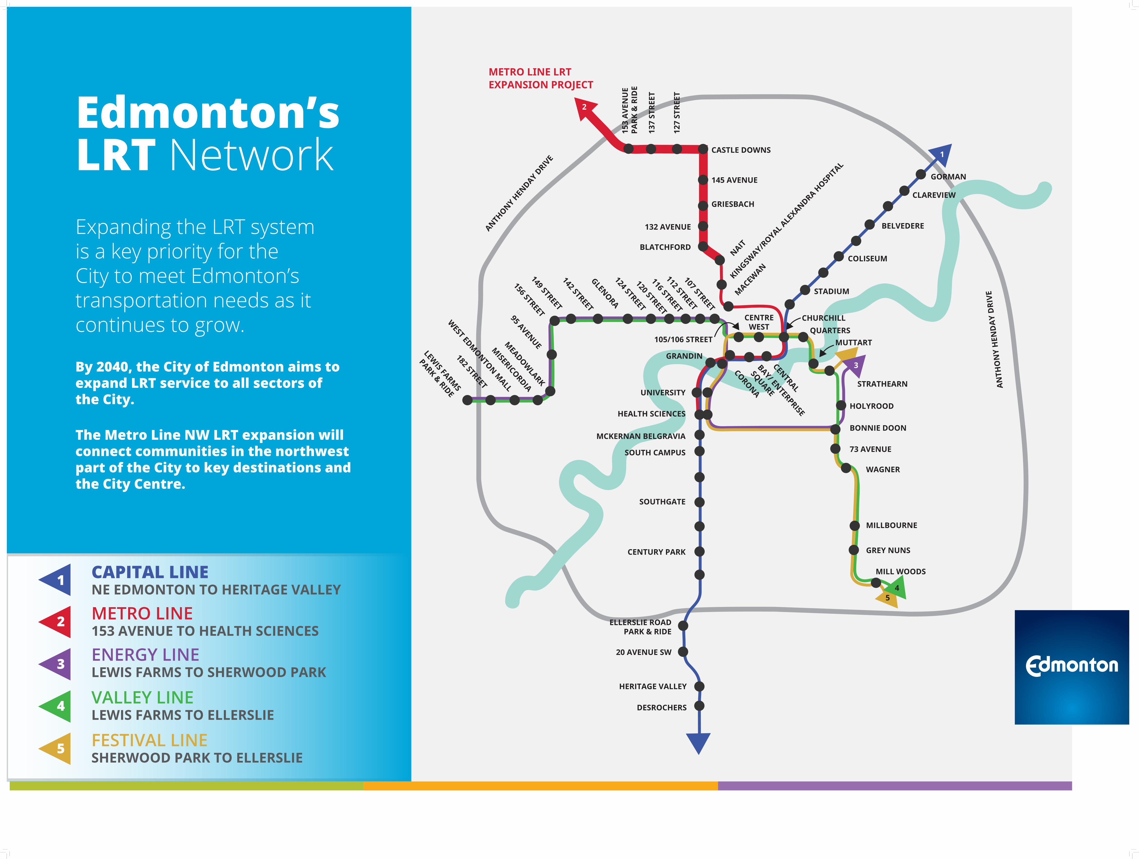
Expanding the LRT system is a key priority for the City to meet Edmonton’s transportation needs as it continues to grow.
By 2040, the City of Edmonton aims to expand LRT service to all sectors of the City.
The Metro Line NW LRT expansion will connect communities in the northwest part of the City to key destinations and the City Centre.
Edmonton’s LRT Network
54
1
2
3
ANTHONY H
ENDAY D
RIVE
153
AVE
NU
EPA
RK &
RID
E
137
STRE
ET
127
STRE
ET
CASTLE DOWNS
145 AVENUE
GRIESBACH
132 AVENUE
BLATCHFORD
NAITKIN
GSWAY/R
OYAL ALEX
ANDRA HOSP
ITAL
MACEWAN
GORMAN
CLAREVIEW
BELVEDERE
COLISEUM
STADIUM
CHURCHILLQUARTERS
MUTTART
CENTREWEST
STRATHEARN
HOLYROOD
BONNIE DOON
73 AVENUE
WAGNER
MILLBOURNE
GREY NUNS
MILL WOODS
CENTRAL
BAY/ ENTERPRISE
SQUARE
CORONA
105/106 STREET
GRANDIN
UNIVERSITY
HEALTH SCIENCES
MCKERNAN BELGRAVIA
SOUTH CAMPUS
SOUTHGATE
CENTURY PARK
ELLERSLIE ROADPARK & RIDE
20 AVENUE SW
HERITAGE VALLEY
DESROCHERS
AN
THO
NY
HEN
DA
Y D
RIVE
LEWIS FARM
S
PARK & RIDE182 STREET
WEST EDM
ONTON MALL
MISERICORDIA
MEADOW
LARK
95 AVENUE
156 STREET149 STREET142 STREETGLENORA124 STREET120 STREET
116 STREET112 STREET107 STREET
METRO LINE LRTEXPANSION PROJECT
1
2
3
4
5
CAPITAL LINE NE EDMONTON TO HERITAGE VALLEY
METRO LINE 153 AVENUE TO HEALTH SCIENCES
ENERGY LINE LEWIS FARMS TO SHERWOOD PARK
VALLEY LINE LEWIS FARMS TO ELLERSLIE
FESTIVAL LINE SHERWOOD PARK TO ELLERSLIE
JuneNovember
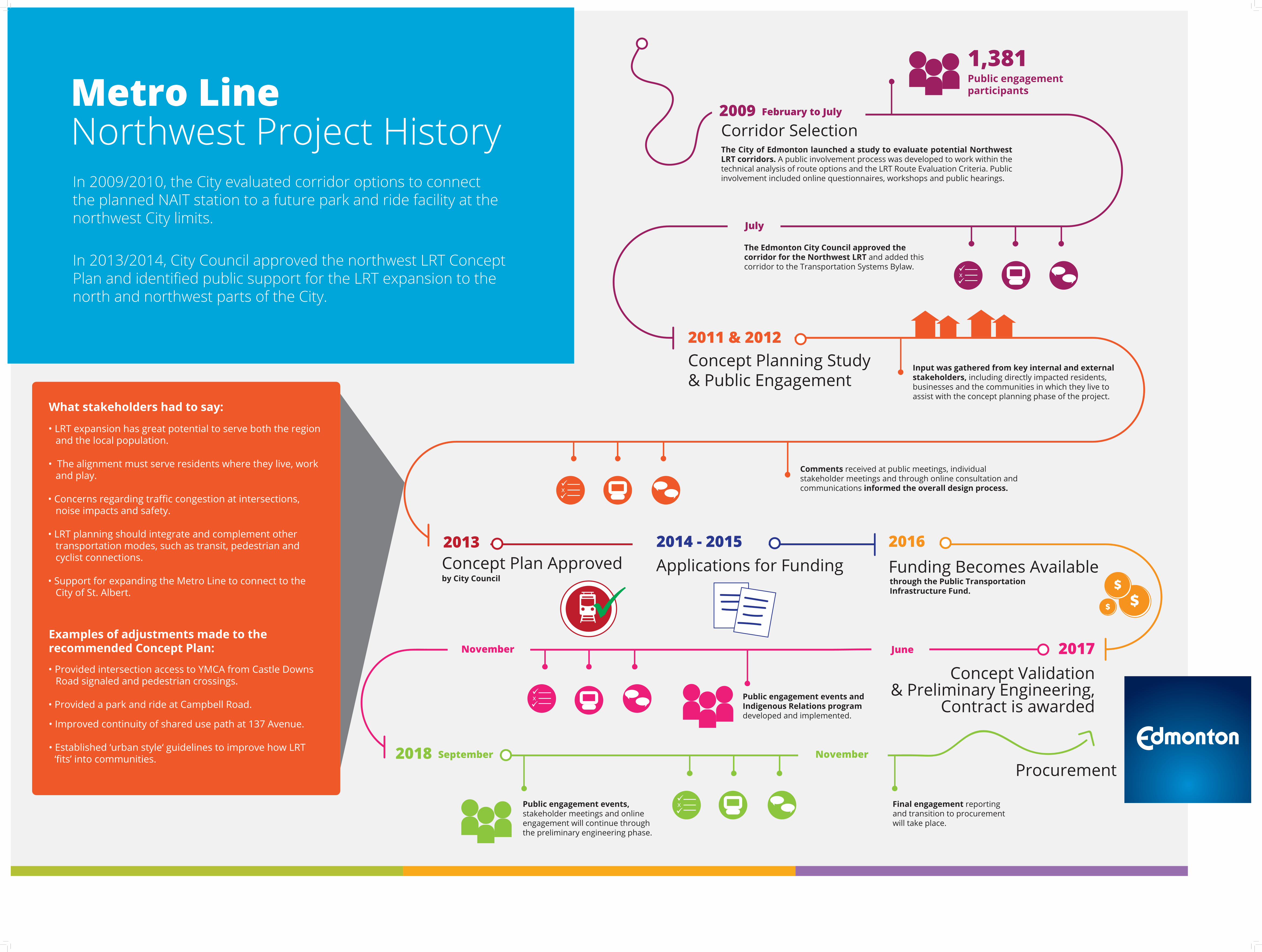
1,381Public engagementparticipants
x
Comments received at public meetings, individual stakeholder meetings and through online consultation and communications informed the overall design process.
Input was gathered from key internal and external stakeholders, including directly impacted residents, businesses and the communities in which they live to assist with the concept planning phase of the project.
Public engagement events and Indigenous Relations program developed and implemented.
Public engagement events, stakeholder meetings and online engagement will continue through the preliminary engineering phase.
Final engagement reporting and transition to procurement will take place.
2009Corridor SelectionThe City of Edmonton launched a study to evaluate potential Northwest LRT corridors. A public involvement process was developed to work within the technical analysis of route options and the LRT Route Evaluation Criteria. Public involvement included online questionnaires, workshops and public hearings.
February to July
July
The Edmonton City Council approved the corridor for the Northwest LRT and added this corridor to the Transportation Systems Bylaw.
2011 & 2012Concept Planning Study& Public Engagement
2013Concept Plan Approvedby City Council
x
2014 - 2015Applications for Funding
2016Funding Becomes Availablethrough the Public Transportation Infrastructure Fund.
2017Concept Validation
& Preliminary Engineering, Contract is awarded
x
2018 September
x
November
Procurement
$$
$
• LRT expansion has great potential to serve both the region and the local population.
• The alignment must serve residents where they live, work and play.
• Concerns regarding traffic congestion at intersections, noise impacts and safety.
• LRT planning should integrate and complement other transportation modes, such as transit, pedestrian and cyclist connections.
• Support for expanding the Metro Line to connect to the City of St. Albert.
What stakeholders had to say:
Examples of adjustments made to the recommended Concept Plan:
• Provided intersection access to YMCA from Castle Downs Road signaled and pedestrian crossings.
• Provided a park and ride at Campbell Road.
• Improved continuity of shared use path at 137 Avenue.
• Established ‘urban style‘ guidelines to improve how LRT ‘fits’ into communities.
Metro Line Northwest Project HistoryIn 2009/2010, the City evaluated corridor options to connect the planned NAIT station to a future park and ride facility at the northwest City limits.
In 2013/2014, City Council approved the northwest LRT Concept Plan and identified public support for the LRT expansion to the north and northwest parts of the City.
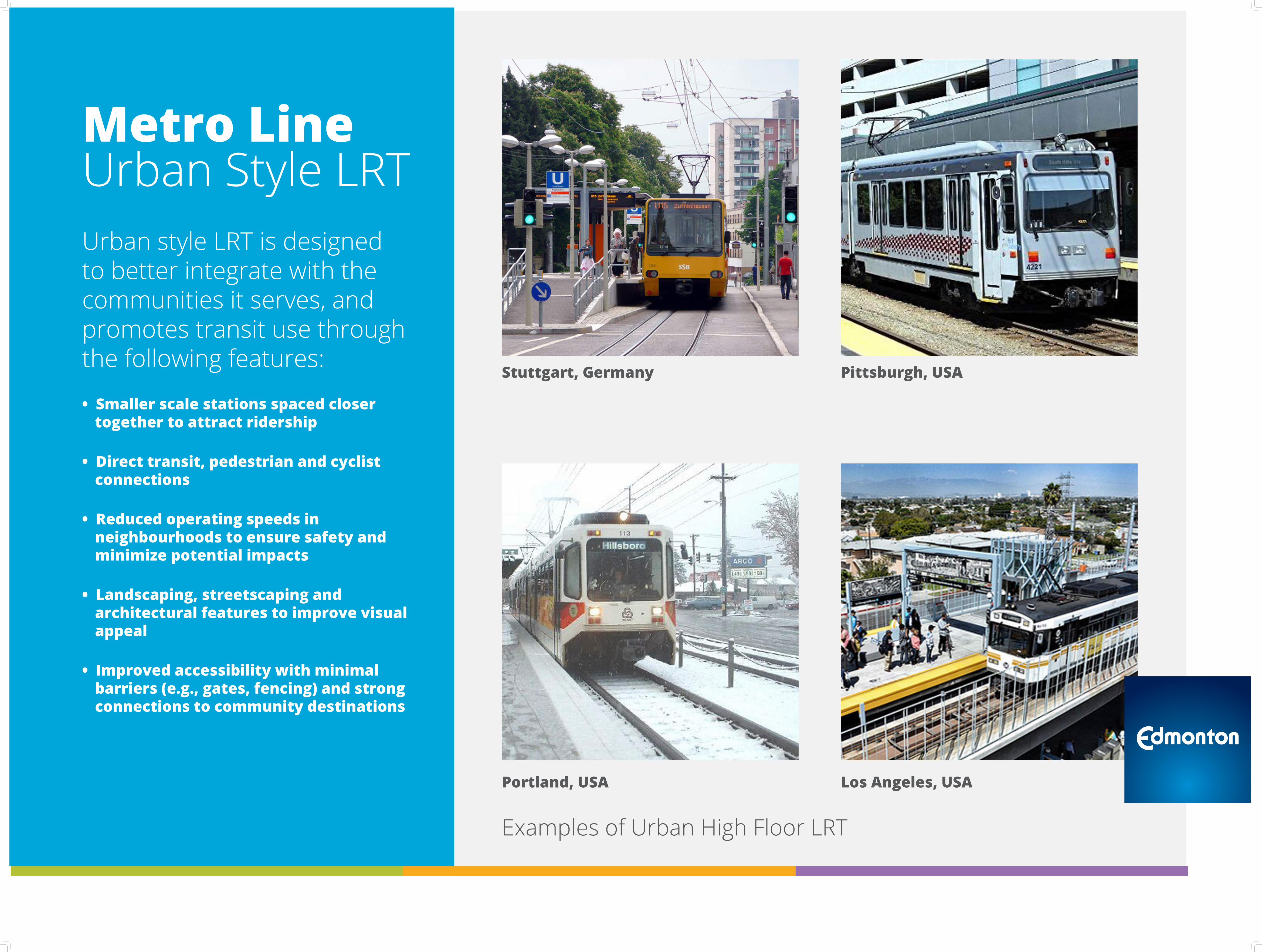
Urban style LRT is designed to better integrate with the communities it serves, and promotes transit use through the following features:
• Smaller scale stations spaced closer together to attract ridership
• Direct transit, pedestrian and cyclist connections
• Reduced operating speeds in neighbourhoods to ensure safety and minimize potential impacts
• Landscaping, streetscaping and architectural features to improve visual appeal
• Improved accessibility with minimal barriers (e.g., gates, fencing) and strong connections to community destinations
Metro LineUrban Style LRT
Stuttgart, Germany Pittsburgh, USA
Portland, USA Los Angeles, USA
Examples of Urban High Floor LRT
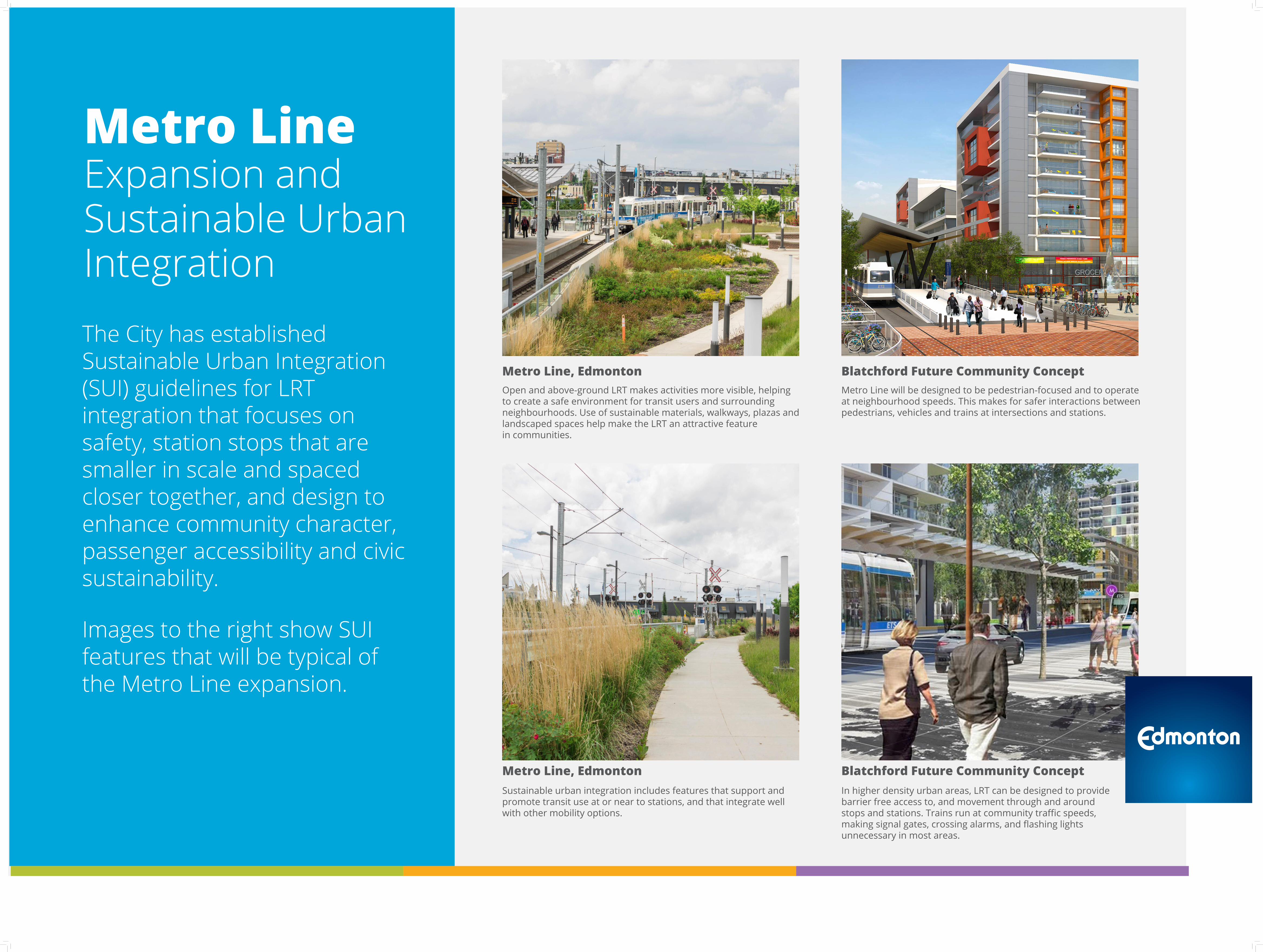
Metro LineExpansion and Sustainable Urban Integration
The City has established Sustainable Urban Integration (SUI) guidelines for LRT integration that focuses on safety, station stops that are smaller in scale and spaced closer together, and design to enhance community character, passenger accessibility and civic sustainability.
Images to the right show SUI features that will be typical of the Metro Line expansion.
Open and above-ground LRT makes activities more visible, helping to create a safe environment for transit users and surrounding neighbourhoods. Use of sustainable materials, walkways, plazas and landscaped spaces help make the LRT an attractive feature in communities.
Blatchford Future Community ConceptMetro Line will be designed to be pedestrian-focused and to operate at neighbourhood speeds. This makes for safer interactions between pedestrians, vehicles and trains at intersections and stations.
Sustainable urban integration includes features that support and promote transit use at or near to stations, and that integrate well with other mobility options.
In higher density urban areas, LRT can be designed to provide barrier free access to, and movement through and around stops and stations. Trains run at community traffic speeds, making signal gates, crossing alarms, and flashing lights unnecessary in most areas.
Blatchford Future Community Concept
Metro Line, Edmonton
Metro Line, Edmonton
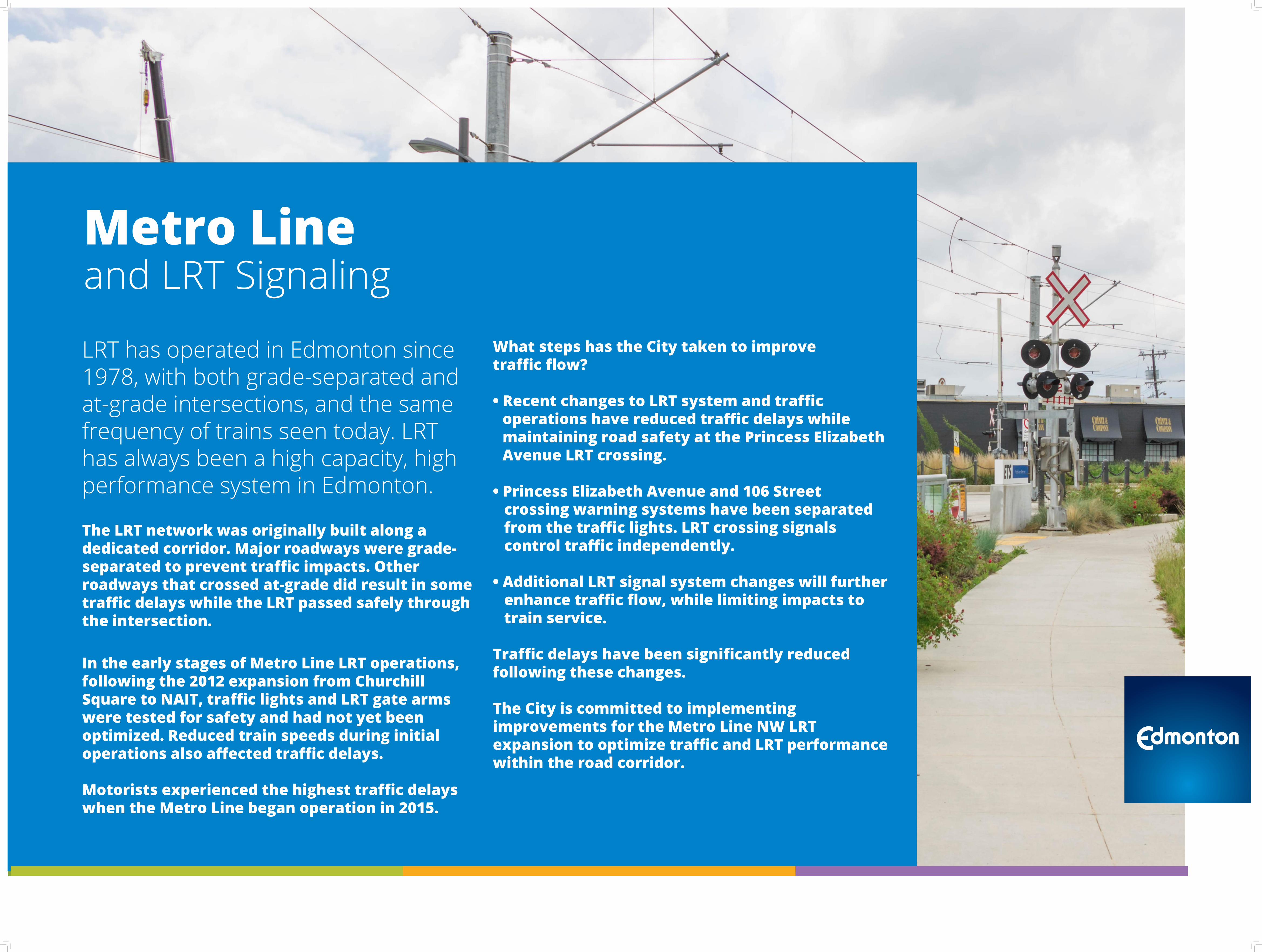
Metro Lineand LRT Signaling
LRT has operated in Edmonton since 1978, with both grade-separated and at-grade intersections, and the same frequency of trains seen today. LRT has always been a high capacity, high performance system in Edmonton.
The LRT network was originally built along a dedicated corridor. Major roadways were grade-separated to prevent traffic impacts. Other roadways that crossed at-grade did result in some traffic delays while the LRT passed safely through the intersection.
In the early stages of Metro Line LRT operations, following the 2012 expansion from Churchill Square to NAIT, traffic lights and LRT gate arms were tested for safety and had not yet been optimized. Reduced train speeds during initial operations also affected traffic delays.
Motorists experienced the highest traffic delays when the Metro Line began operation in 2015.
What steps has the City taken to improve traffic flow?
• Recent changes to LRT system and traffic operations have reduced traffic delays while maintaining road safety at the Princess Elizabeth Avenue LRT crossing.
• Princess Elizabeth Avenue and 106 Street crossing warning systems have been separated from the traffic lights. LRT crossing signals control traffic independently.
• Additional LRT signal system changes will further enhance traffic flow, while limiting impacts to train service.
Traffic delays have been significantly reduced following these changes.
The City is committed to implementing improvements for the Metro Line NW LRT expansion to optimize traffic and LRT performance within the road corridor.
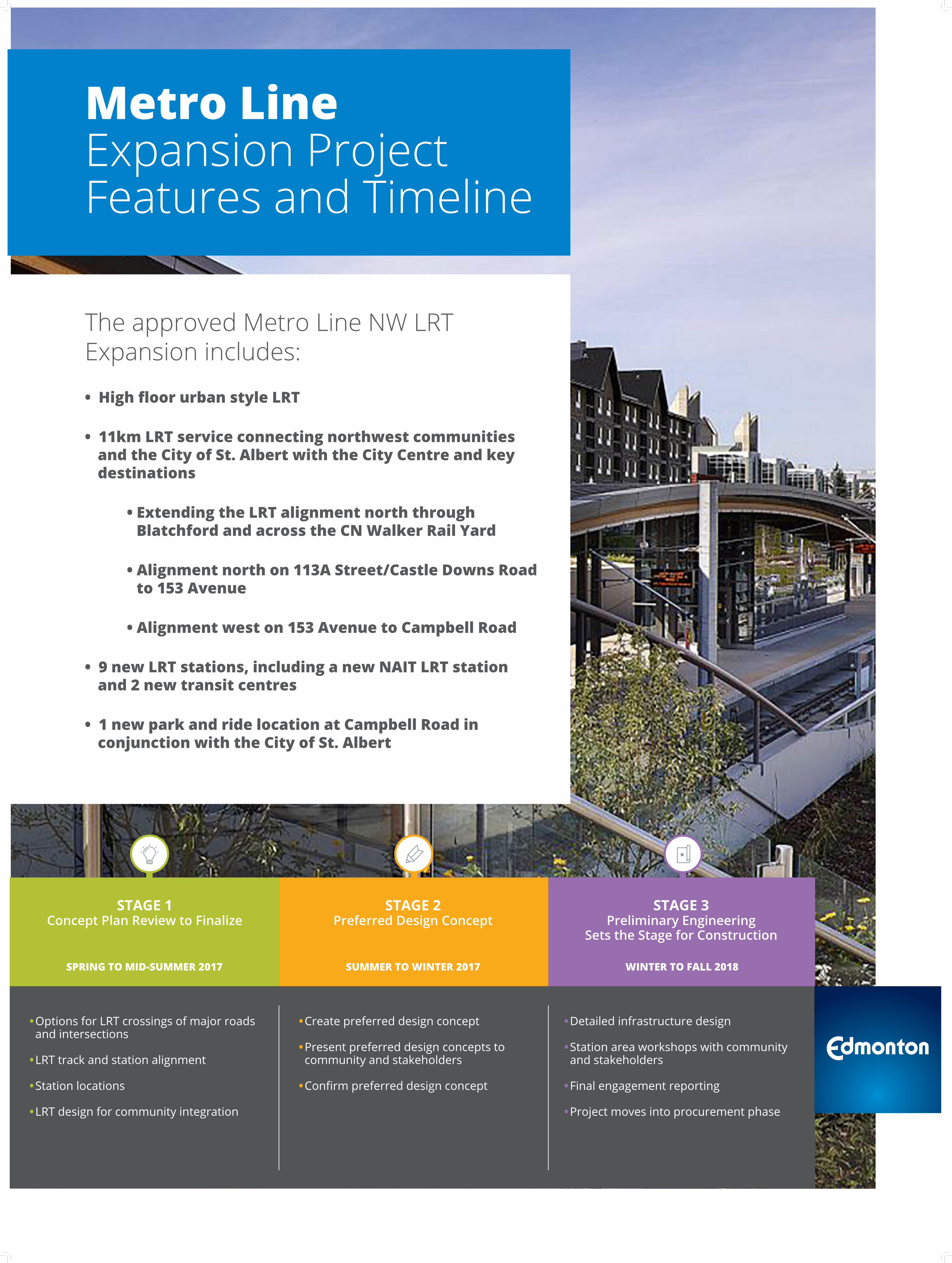
The approved Metro Line NW LRT Expansion includes:
• High floor urban style LRT
• 11km LRT service connecting northwest communities and the City of St. Albert with the City Centre and key destinations
• Extending the LRT alignment north through Blatchford and across the CN Walker Rail Yard
• Alignment north on 113A Street/Castle Downs Road to 153 Avenue
• Alignment west on 153 Avenue to Campbell Road
• 9 new LRT stations, including a new NAIT LRT station and 2 new transit centres
• 1 new park and ride location at Campbell Road in conjunction with the City of St. Albert
Metro LineExpansion Project Features and Timeline
• Create preferred design concept
• Present preferred design concepts to community and stakeholders
• Confirm preferred design concept
• Detailed infrastructure design
• Station area workshops with community and stakeholders
• Final engagement reporting
• Project moves into procurement phase
SUMMER TO WINTER 2017SPRING TO MID-SUMMER 2017 WINTER TO FALL 2018
• Options for LRT crossings of major roads and intersections
• LRT track and station alignment
• Station locations
• LRT design for community integration
STAGE 1 Concept Plan Review to Finalize
STAGE 2 Preferred Design Concept
STAGE 3 Preliminary Engineering
Sets the Stage for Construction
153 AVENUE153 AVENUE 137 STREET137 STREET
127 STREET127 STREET
CASTLE DOWNSCASTLE DOWNS
145 AVENUE145 AVENUE
137 AVENUE137 AVENUE
132 AVENUE132 AVENUE
BLATCHFORDBLATCHFORD
NAITNAIT
CHURCHILLCHURCHILL
Kingsway
Kingsway
111 Ave NW111 Ave NW
124 St NW
124 St NW
104 Ave NW104 Ave NW
Jasper AveJasper Ave
107 Ave NW107 Ave NW
97 St NW
97 St NW
Princess Eliza
beth
Ave NW
Princess Eliza
beth
Ave NW
101 St NW
101 St NW
Yellowhead TrialYellowhead Trial
118 Ave NW118 Ave NW
St. Albert Trial NW
St. Albert Trial NW
Groat Rd N
WG
roat Rd NW
127 St NW
127 St NW
Stony Plain Rd NW
Stony Plain Rd NW
Yellowhead TrialYellowhead Trial
137 Ave NW137 Ave NW127 St N
W127 St N
W
97 St NW
97 St NW
153 Ave NW153 Ave NW
82 St NW
82 St NW
137 Ave NW137 Ave NW
82 St NW
82 St NW
118 Ave NW118 Ave NW
111 Ave NW111 Ave NW
112 Ave NW112 Ave NW
Rossdal
e RD N
W
Rossdal
e RD N
W
Scon
a RD
NW
Scon
a RD
NW
105 St NW
105 St NW
109 St NW
109 St NW
113a St NW
113a St NW
MACEWANMACEWAN
KINGSWAY/ ROYALALEXANDRA HOSPITALKINGSWAY/ ROYALALEXANDRA HOSPITAL
127 Ave NW127 Ave NW 127 Ave NW127 Ave NW
142 St NW
142 St NW
Campbell Rd N
W
Campbell Rd N
W
BLATCHFORDBLATCHFORD
Future St. AlbertPark and Ride
Future St. AlbertPark and Ride
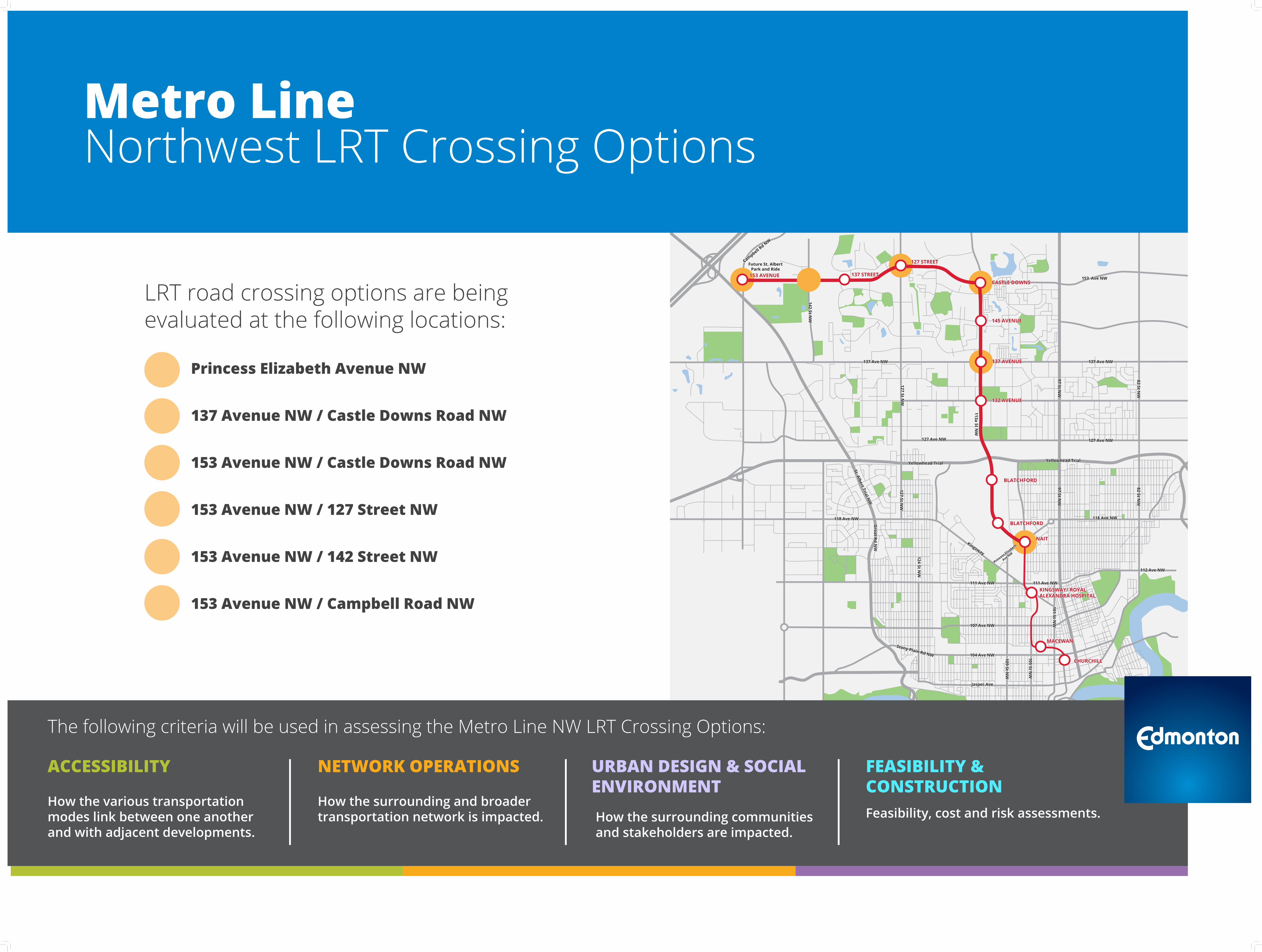
ACCESSIBILITY
How the various transportation modes link between one another and with adjacent developments.
The following criteria will be used in assessing the Metro Line NW LRT Crossing Options:
NETWORK OPERATIONS
How the surrounding and broader transportation network is impacted.
URBAN DESIGN & SOCIAL ENVIRONMENTHow the surrounding communities and stakeholders are impacted.
FEASIBILITY & CONSTRUCTIONFeasibility, cost and risk assessments.
Metro LineNorthwest LRT Crossing Options
LRT road crossing options are being evaluated at the following locations:
Princess Elizabeth Avenue NW 137 Avenue NW / Castle Downs Road NW
153 Avenue NW / Castle Downs Road NW
153 Avenue NW / 127 Street NW 153 Avenue NW / 142 Street NW
153 Avenue NW / Campbell Road NW
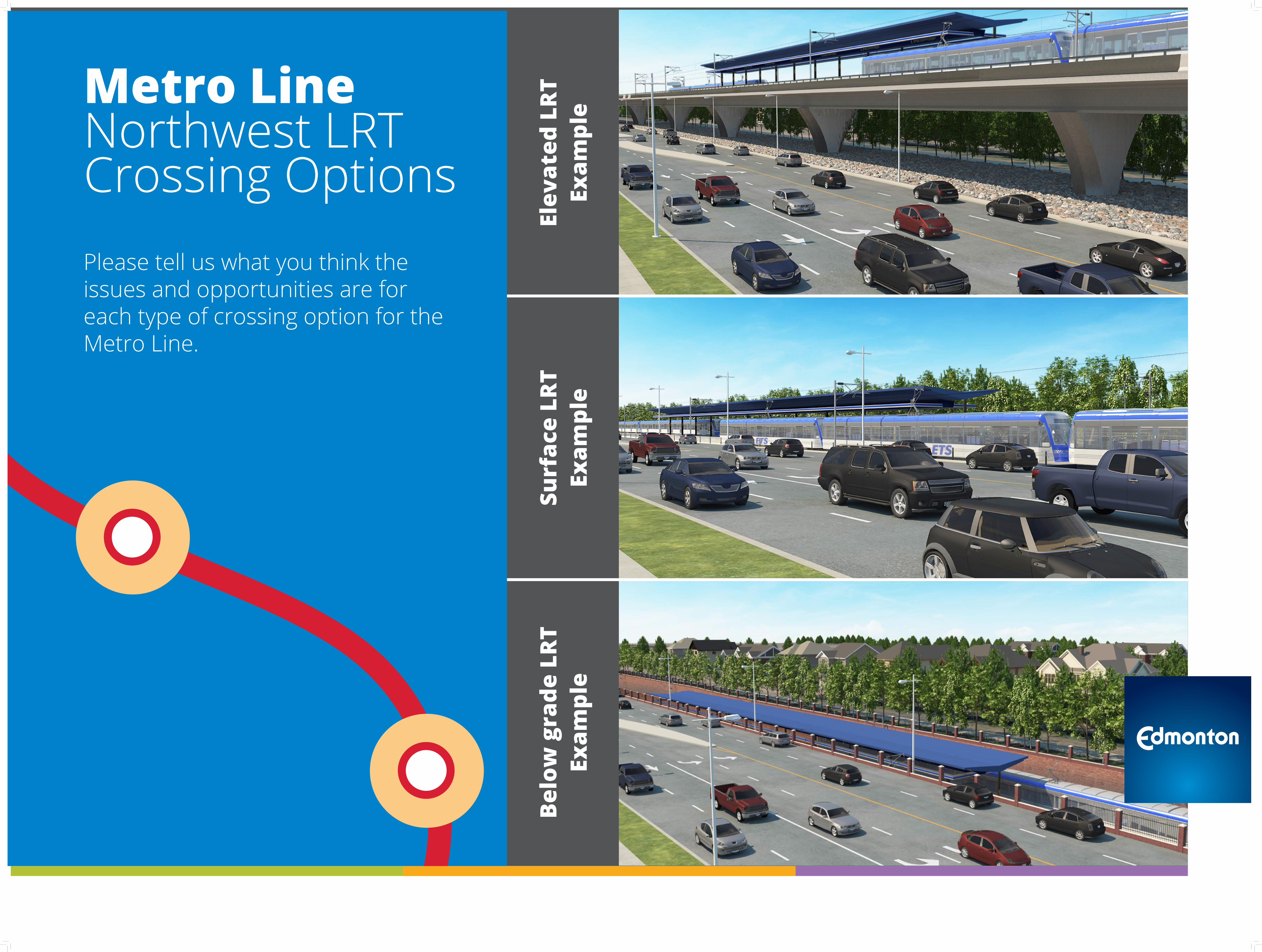
Metro LineNorthwest LRT Crossing Options
Surf
ace
LRT
Ex
ampl
eBe
low
gra
de L
RT
Exam
ple
Elev
ated
LRT
Ex
ampl
e
Please tell us what you think the issues and opportunities are for each type of crossing option for the Metro Line.
153 AVENUE153 AVENUE 137 STREET137 STREET
127 STREET127 STREET
CASTLE DOWNSCASTLE DOWNS
145 AVENUE145 AVENUE
137 AVENUE137 AVENUE
132 AVENUE132 AVENUE
BLATCHFORDBLATCHFORD
NAITNAIT
CHURCHILLCHURCHILL
Kingsway
Kingsway
111 Ave NW111 Ave NW
124 St NW
124 St NW
104 Ave NW104 Ave NW
Jasper AveJasper Ave
107 Ave NW107 Ave NW
97 St NW
97 St NW
Princess Eliza
beth
Ave NW
Princess Eliza
beth
Ave NW
101 St NW
101 St NW
Yellowhead TrailYellowhead Trail
118 Ave NW118 Ave NW
St. Albert Trail NW
St. Albert Trail NW
Groat Rd N
WG
roat Rd NW
127 St NW
127 St NW
Stony Plain Rd NW
Stony Plain Rd NW
Yellowhead TrailYellowhead Trail
137 Ave NW137 Ave NW
127 St NW
127 St NW
97 St NW
97 St NW
153 Ave NW153 Ave NW
82 St NW
82 St NW
137 Ave NW137 Ave NW
82 St NW
82 St NW
118 Ave NW118 Ave NW
111 Ave NW111 Ave NW
112 Ave NW112 Ave NW
Rossdal
e RD N
W
Rossdal
e RD N
W
Scon
a RD
NW
Scon
a RD
NW
105 St NW
105 St NW
109 St NW
109 St NW
113a St NW
113a St NW
MACEWANMACEWAN
KINGSWAY/ ROYALALEXANDRA HOSPITALKINGSWAY/ ROYALALEXANDRA HOSPITAL
127 Ave NW127 Ave NW 127 Ave NW127 Ave NW
142 St NW
142 St NW
Campbell Rd NW
Campbell Rd NW
BLATCHFORDBLATCHFORD
Future St. AlbertPark and Ride
Future St. AlbertPark and Ride
DOWNTOWNDOWNTOWN
QUEEN MARYPARK
QUEEN MARYPARK
OLIVEROLIVER
WESTMOUNTWESTMOUNT
INGLEWOODINGLEWOOD
PRINCE CHARLESPRINCE CHARLES
SPRUCEAVENUESPRUCEAVENUE
ALBERTAAVENUEALBERTAAVENUE
RIVERDALERIVERDALE
ROSSDALEROSSDALE
DELTONDELTON
MCCAULEYMCCAULEY
BOYLE STREETBOYLE STREET
CALDERCALDER LAUDERDALELAUDERDALE
KENSINGTONKENSINGTON ROSSLYNROSSLYN
GRIESBACHGRIESBACHCARLISLECARLISLE
BARANOWBARANOW
CAERNARVONCAERNARVON
BEAUMARISBEAUMARIS
DUNLUCEDUNLUCEOXFORDOXFORD
CARLTONCARLTON
CUMBERLANDCUMBERLAND
HUDSONHUDSON
ATHLONEATHLONE
PEMBINAPEMBINA
KILLARNEYKILLARNEY
GLENGARRYGLENGARRY
NORTHMOUNTNORTHMOUNT
EVANSDALEEVANSDALE
EAUX CLAIRESEAUX CLAIRES
WELLINGTONWELLINGTON
CENTRALMCDOUGALL
CENTRALMCDOUGALL
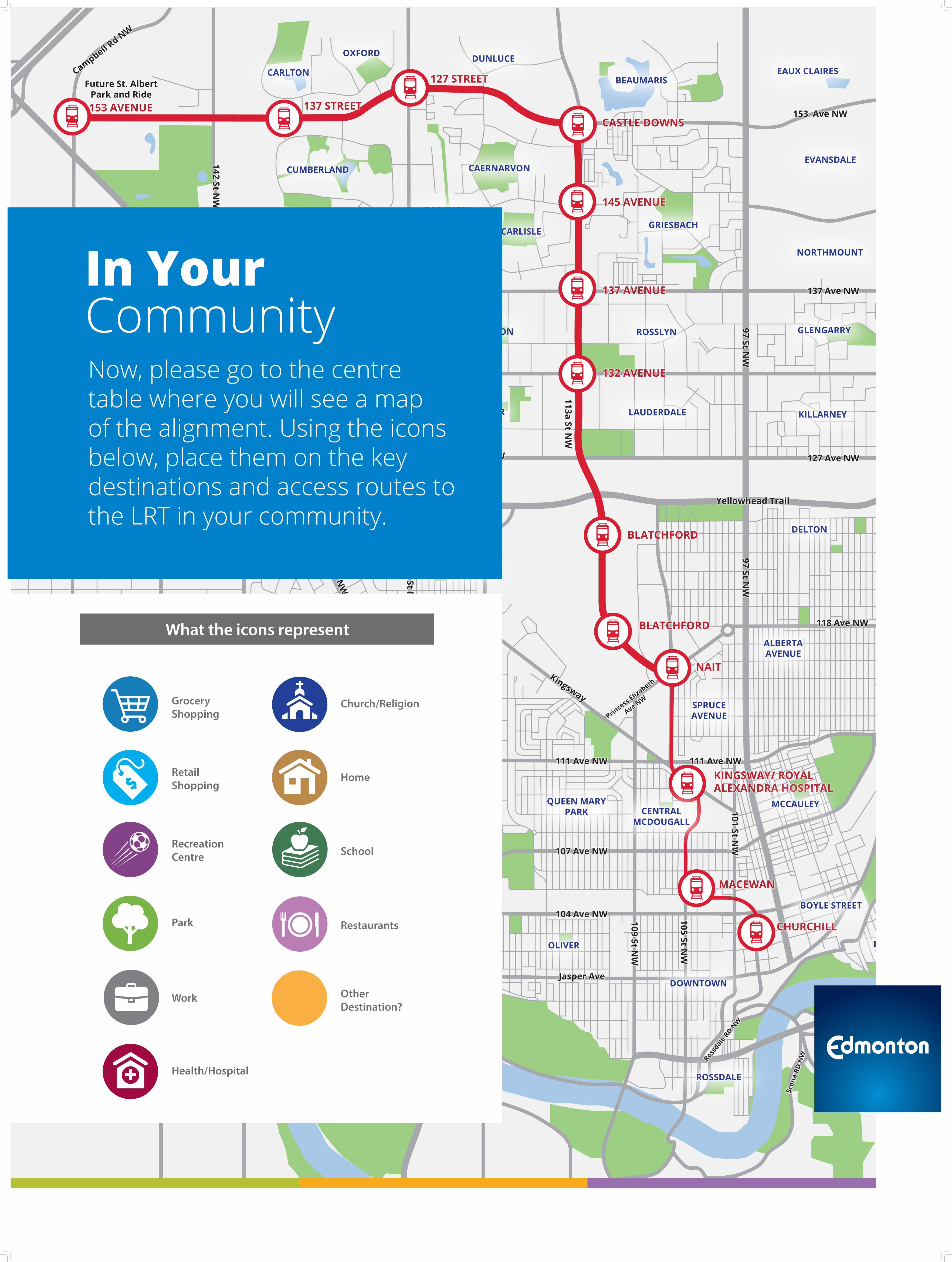
Now, please go to the centre table where you will see a map of the alignment. Using the icons below, place them on the key destinations and access routes to the LRT in your community.
In YourCommunity
Grocery Shopping
Retail Shopping
Recreation Centre
Park
Work
Health/Hospital
Church/Religion
Home
School
Restaurants
Other Destination?
What the icons represent