Embed Size (px)
Citation preview
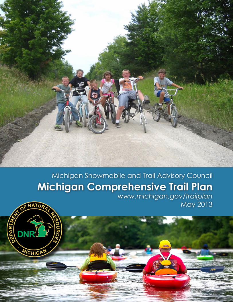
Michigan Snowmobile and Trail Advisory Council
Michigan Comprehensive Trail Planwww.michigan.gov/trailplan
May 2013
MICHIGAN
COMPREHENSIVE
TRAILS PLAN As required by PA 45 of 2010
2013-2018
_______________________________________________________
MICHIGAN SNOWMOBILE AND TRAILS ADVISORY COUNCIL
MICHIGAN DEPARTMENT OF NATURAL RESOURCES
MAY, 2013

Trail: A path, route, way, right of way, or corridor posted, signed or designated as open for travel by the general public.
An opportunity to experience solitude or companionship, recreation or challenge; an opportunity for the appreciation of nature; a means of achieving renewal of body, mind and spirit.
TABLE OF CONTENTS
MICHIGAN SNOWMOBILE AND TRAILS ADVISORY COUNCIL ........................ 1
EXECUTIVE SUMMARY ........................................................................... 2
CHAPTER 1 - INTRODUCTION ................................................................ 13
CHAPTER 2 - RECOMMENDATIONS AND ACTIONS ................................... 25
CHAPTER 3 - MOTORIZED TRAIL SYSTEM .............................................. 39
OFF-ROAD VEHICLE (ORV) TRAIL SYSTEM .................................... 39
SNOWMOBILE TRAIL SYSTEM ......................................................... 45
CHAPTER 4 - NON-MOTORIZED TRAIL SYSTEM ...................................... 56
LOOPED TRAILS ............................................................................ 56
EQUESTRIAN TRAILS ..................................................................... 75
LINEAR TRAILS .............................................................................. 93
CHAPTER 5 - WATER TRAILS .............................................................. 103
APPENDIX 1 2012 TRAIL USER SURVEY ANALYSIS ............................ 113
APPENDIX 2 ORV PLAN .................................................................. 118
APPENDIX 3 CONNECTING MICHIGAN ............................................... 118
APPENDIX 4 MICHGIAN TRAILS AT THE CROSSROAD .......................... 118
APPENDIX 5 2011 EQUINE TRAILSWAYS SUBCOMMITTEE REPORT ..... 118
APPENDIX 6 STATEWIDE TRAIL NETWORK PLAN ............................... 119
APPENDIX 7 ACKNOWLEDGEMENTS ................................................. 149
APPENDIX 8 REFERENCES .............................................................. 151
APPENDIX 9 SUMMARY OF PUBLIC COMMENTS ................................. 151
Michigan Trail Plan Page 1
MICHIGAN SNOWMOBILE AND TRAILS ADVISORY COUNCIL The Michigan Snowmobile and Trails Advisory Council (MSTAC) was created by PA 46 of 2010. The 11-member council was appointed by the governor and includes five representatives of the snowmobile and ORV community (three or more must be the owner of a snowmobile) and two members from the Equine Trailways Subcommittee. One of the members of the council must be from the Upper Peninsula.
The MSTAC is charged with advising the director of the DNR and the governor on the creation, development, operation and maintenance of motorized and non-motorized trails in this state. In providing this guidance, the advisory council shall “seek to create a linked trail system.”
Members of the committee are:
Frank Wheatlake (Chair/Snowmobile)
Sandra Batie (Equine)
James Dickie (Snowmobile)
James Duke (Snowmobile/U.P. Resident)
Thomas Dunn (ORV)
Michael Foote (Equine)
Carolyn Kane (Non-motorized)
Nancy Krupiarz (Non-motorized)
William Manson, Jr. (Snowmobile)
Erin McDonough (Non-motorized)
Greg Yager (ORV)
MSTAC conducts much of its work through four subcommittees: Equestrian Trailways, Non-Motorized, ORV, and Snowmobile Subcommittees. The Equestrian Trailways Subcommittee (ETS) is called for in Act 45 of 2010. PA 46 of 2010 charged the ETS with preparing an equestrian plan which can be found in Appendix X. The ORV, Snowmobile, Equestrian and Non-motorized (excluding the equestrian portion) portions of this plan were prepared by the respective subcommittees, assisted by DNR staff and reviewed, edited and adopted by MSTAC. Stakeholders also provided assistance on the Water Trails Chapter of the plan. All comments that were received as a result of the public review of the plan were considered by the appropriate subcommittees and recommendations regarding the comments were provided by the subcommittees to MSTAC for consideration. A summary of the public comments is provided in Appendix 9. Appendix 7 identifies the participants in these trail user subcommittees.

Michigan Trail Plan Page 2
EXECUTIVE SUMMARY The Michigan Snowmobile and Trails Advisory Council (MSTAC) and the Equine Trailways Subcommittee (ETS) were established with enactment of Public Acts 45 and 46 of 2010. PA 45 of 2010 defined equestrian (EQ) use on state lands and charged the ETS, MSTAC, and the Department of Natural Resources (DNR) with the responsibility of developing recommendations for a state trail system. The act calls for a three step planning process for the state trail system initiated by ETS preparing an equine trail plan and submitting it to MSTAC by June of 2011. The ETS 2011 Report can be found at: http://www.michigan.gov/documents/dnr/2011RecReportETS_Final_030212._378261_7.pdf. Once MSTAC receives the ETS equine trail plan, it has one year to prepare a plan for a state trail system that considers all trail users. Under the law, MSTAC then provides its plan to the DNR which has one year to prepare and adopt a comprehensive trail plan.
The following plan is intended to meet the planning requirements, but more importantly, acknowledge Michigan’s position as the nation’s Trail State. Michigan has an incredible array of trails, developed and maintained by an extensive collaboration among state and local governments, non-profits, foundations and volunteers. The following plan provides recommendations on how to improve this system and to ensure the continued benefits of national prominence. While much has been accomplished there are significant opportunities left to address. The coalition that has created and is managing this spectacular trail system must together continue to plan, manage and maintain the system while recognizing the challenges presented by existing funding constraints.

Michigan Trail Plan Page 3
INTRODUCTION - CHAPTER ONE
Chapter 1 provides an overview of the extensive trail network that provides hours of fun, improved health, and lasting memories for Michigan’s wide range of trail users from snowmobilers to paddlers, hikers to mountain bikers, and road bike enthusiasts to off-road vehicle (ORV) riders. The Michigan trail system also provides access to Michigan’s many diverse natural resource offerings including hunting, fishing, wildlife viewing, berry and mushroom picking and swimming. Trails promote a healthy lifestyle and increase opportunities to explore nature. The trail network is an important economic driver for Michigan’s economy; hosting festivals and races, attracting out-of-state guests and new residents, and assisting in placemaking. This system is the result of an amazing network of partnerships that have acquired, developed and are maintaining trails.
MSTAC and the Michigan Department of Natural Resources’ shared vision for Michigan’s trail system is:
The State of Michigan’s trail system is a significant statewide sustainable network of trails in quantity and quality that takes into account the full spectrum of trail users.
The system has sufficient funding to allow existing trails to be appropriately maintained and to expand to meet user and community needs.
Every home in the state is a trailhead because the network provides close-to-home opportunities for transportation, healthful exercise, recreation and enhanced sense of place.
The network provides connections to parks, urban centers, cultural and conservation areas. The network also provides access to and enjoyment of Michigan’s abundant natural, cultural and scenic resources while also conserving those resources.
Trails are linked to allow citizens and visitors to experience urban and rural environments on the same network with minimal conflicts.
Amenities to increase the enjoyment of trail use are easily accessed in adjoining villages, towns and cities, and those communities enjoy the economic benefits that are derived from the statewide trail network.
A full range of opportunities from universal access to challenging trails are available throughout the state.
The public has an electronic portal to access trail information and related amenities.
Trail planning and implementation are coordinated among all levels of government.
The system is acquired, developed, maintained and promoted through partnerships among units of governments, the private sector, volunteer organizations and non-profit organizations.
Michigan Trail Plan Page 4
RECOMMENDATIONS AND ACTIONS - CHAPTER TWO
Chapter 2 identifies eight priority recommendations with associated key actions that should be implemented to assist in achieving the vision and ensuring that Michigan’s trail system continues to be nationally recognized for its quality, extent, and the experiences that the trails and their host communities provide. The priority recommendations reflect common threads regarding issues, threats and opportunities identified for all trail types and trail user’s interest as reflected in trail user surveys. The priority recommendations are:
Trails are maintained to ensure a sustainable and quality trail system by establishing development and maintenance guidelines.
Key recommendations include: adopting maintenance guidelines for each trail type, regular adjustment of fees to reflect current development and maintenance costs, and removal of impediments for volunteer involvement.
Expand trails and trail experiences and opportunities to ensure access to trail systems, outdoor recreation opportunities and to Michigan’s treasured natural and cultural resources.
Key recommendations include: identifying and addressing critical gaps in the regional trail networks, including trails in local and regional transportation plans, increasing the number of water, heritage and cultural trails, coordinating trail planning among all trail providers, coordinating trails to ensure access to a diversity of recreational opportunities and ensuring the protection of natural resources.
The Michigan Snowmobile and Trails Advisory Council (MSTAC) leads the effort to maintain and enhance Michigan’s reputation as the trail state.
Key recommendations include: MSTAC establishing criteria for determining priorities for funding, convening a biennial trail summit, creating a process for anticipating and mediating conflicts between users, and tracking progress in implementing the trail plan utilizing an adaptive management approach.
Link trails, trail users and adjoining towns to create memorable trail experiences and enhance local economic prosperity.
Key recommendations include: designating a position within DNR to work with local units of governments to create “trail towns”, allowing for better directional signage to guide trail users into local communities, convening trail town communities on a regular basis; and documenting how trails contribute to local prosperity.
Develop, enhance and celebrate partnerships and collaborations to acquire, develop and maintain trails and trail connections.
Key recommendations include: improving the process for creating trail “friends” groups, creating a development plan with partners to address critical trail linkages, and maximizing the use of volunteer organizations to provide maintenance of trails.
Implement a marketing plan, including an electronic portal that allows citizens and visitors to be aware of all trails and related amenities.
Key recommendations include: creating a marketing program for the state’s trail system, obtaining national exposure for Michigan’s trail system, coordinating all trail
Michigan Trail Plan Page 5
marketing efforts and creating an online portal that allows a trail user to plan trail experiences.
Develop funding sources and mechanisms for trail maintenance and to fill the funding gaps for acquisition and development.
Key recommendations include: securing funding to maintain existing trails and expand trails to meet user and community needs, transitioning the Recreation Passport to an “opt out” option to help support the trail system and determine revenue needs compared to available revenues and identify means to address those funding gaps.
Ensure that the state’s trail system compliments other plans and planning efforts, conserves the resources that enhance the system, and is compatible with other values and programs associated with the land.
Key recommendations include: Trail development and maintenance must be compatible and consistent with other state land management plans; create one trail approval process in the DNR and make it transparent, address emerging trends; promote leave no trace ethic and interpret natural and cultural features on newly developed trails.
The Motorized Trail System, Non-Motorized Trail System and Water Trail System chapters of the plan examine in great detail each specific trail type; identify a strategic vision for each trail type, prioritize trail links and make recommendations for growing and improving the system. Each chapter was written by a MSTAC subcommittee with the assistance of DNR staff. The chapters reflect the interests of the respective trail users. For each trail type, the plan also identifies the existing trail system, opportunities for related business development; private sector involvement and investment, and threats to expansion of the system.
Michigan Trail Plan Page 6
MOTORIZED TRAIL SYSTEM - CHAPTER THREE
ORV Trail System
The ORV trail system is comprised of the Cycle Conservation Club (CCC) motorcycle trail, designated routes, open state forest roads, scramble areas, open county roads and shoulders of county roads. The ORV system is guided by PA 451, 1994, Part 811 and a strategic plan prepared by the ORV Subcommittee of the MSTAC and adopted by the DNR.
Priorities for the ORV trail system include:
Construct a route running parallel to the Michigan Cross Country Cycle Trail (MCCCT) in the Lower Peninsula for all types of ORVs and a similar route in the Upper Peninsula extending from Wisconsin to Drummond Island.
Proactively plan for the opening of certain state forest roads in the Lower Peninsula and snowmobile trails. Construct two routes in the Lower Peninsula extending from the central Lower Peninsula to Mackinac City on the east and west side and a loop going completely around the Upper Peninsula.
Identify and/or develop ORV connectors open to ORVs of all types between towns, trails and other points of interest.
Develop with local trail sponsors and the US Forest Service a trail marker that identifies ORV connector routes.
Five year goals for improving the ORV Trail system:
Continue to implement the 2008 ORV Management Plan.
Design new trails with safety as a primary concern.
Increase user fees to support ORV trail development and maintenance needs and to provide increased safety training and law enforcement. An inflationary escalator should be included in any new fee authorization.
Regularly review training programs for effectiveness.
Continue trail expansion as funding becomes available with a southern Michigan focus.
Proactively explore and address issues related to expanding the trail system to public and private lands.
Construct and manage trails to DNR/industry guidelines to control environmental impacts.
Snowmobile Trail System
The snowmobile trail system is comprised of groomed trails located throughout the state on dedicated trail easements of which 50% are on private lands. The system is maintained by volunteers through a grant- in-aid program administered by the DNR. Snowmobiles are also allowed to operate off trail on state and federal forest lands (except in the Huron Manistee National Forests) and in state parks and recreation areas when sufficient snow is available. The Snowmobile Subcommittee of MSTAC advises the DNR on the snowmobile trails programs by establishing goals and priorities for the program.

Michigan Trail Plan Page 7
Priorities and five year goals for the snowmobile trails program:
Increase enforcement patrols on the snowmobile trails to assist in increasing compliance of the trail permit system.
Increase fines for lack of trail permit.
Expand cost-shared expenses on multiple use trails and systems.
Stabilize the trail network by acquiring easements on private lands utilizing the Permanent Snowmobile Trail Fund.
Address equipment funding shortfalls.
Attract new members to grant sponsor organizations to continue the hard work of current grant sponsors and to gain valuable knowledge through mentoring.
Continue to match the program with available revenue which may require changes in equipment purchases, limit in future enhancements to the program and possible retraction in the amount of new trails.
NON-MOTORIZED TRAIL SYSTEMS - CHAPTER FOUR
Looped Trail System
For purpose of this plan, looped trails generally have a single start and end point within a specific area (attached to a trailhead, campground or other significant feature) and offer trails with a variety of lengths. Looped trails are used by hikers, trail runners, equestrians, mountain bikers, people on snowshoes, dog sledders and cross country skiers. Specific visions and opportunities are identified for mountain biking, cross country skiing and hiking/running/snowshoeing.
Priorities for the looped trail system:
Existing looped trail facilities need to be upgraded and maintained for year-round use.
Streamline and coordinate the new trail proposal process within the DNR.
Once the existing looped trail system is improved and the trail proposal process enhanced, then the opportunities to address looped trail “gaps” and regional needs can be carried out. Looped trail gaps, regional needs, and opportunities are too numerous to mention but should be prioritized by the following criteria:
o There is an interest in creating “friends organizations” to help with trail maintenance, and promotion.
o Provides access to scenic beauty, water features or other outstanding natural or cultural resources.
o Links to other recreational facilities.
o Provides new recreational opportunities or addresses user conflict from over-use of a nearby looped trail.
o Assists in enhancing local economic prosperity.

Michigan Trail Plan Page 8
Five year goals for the looped trail system are: All existing designated looped trails are improved and maintained to guidelines.
Amenities are provided on the trails to meet user needs including signage, benches, trailhead, and restrooms where necessary
Looped trails are marketed and promoted so that Michigan citizens and visitors are aware of the vast system of looped trail opportunities.
Citizens and visitors have access to current trail conditions to help in planning their outing.
Management plans are created for each looped trail system and yearly inspections are conducted to ensure that the looped trails are being managed according to the management plan.
Specific priorities were identified for cross country, hiking and mountain biking.
Cross Country Skiing Priorities:
Keep existing cross country ski trails maintained and groomed.
Add amenities to increase the positive experiences at popular trail systems, including warming facilities and restrooms.
Promote current cross country ski systems with adequate signage, marketing and up to date trail and grooming reports. Promote skiing as a healthy lifestyle sport to help combat obesity in our state.
Keep skiing affordable and accessible to citizens and visitors.
Create and maintain an inventory of all cross country ski trails in the state,
Organize the cross country ski providers in the state to improve promotion, resolve conflicts, share best practices, increase visibility and clout.
Improve the process for partners to develop and maintain cross country ski trails on state land.
Improve process for permitting ski races and events on state land recognizing the need for flexibility due to changing weather conditions.
Prepare a study on the economic impacts of cross country skiing in the state.
Protect the integrity of groomed trails (snowshoes, ORV and others can ruin groomed trails).
Explore the opportunity to have hut-to-hut ski trail systems (the huts could be public or privately run).
Create a “best management practices” document for grooming and maintaining trails and encourage its use by all trail providers.
Educate winter sport enthusiasts about appropriate use of trails and the harm that they can cause by inappropriately using trails groomed for a particular sport.
Identify and pursue stable funding sources to develop and maintain cross country ski trails.
Michigan Trail Plan Page 9
Adequate signage for skiers at trails should be maintained. Signage and promotion on area ski trails on roads and highways should be clearly marked and promoted.
Area partnerships between local government units, local clubs, service groups and private businesses should be encouraged.
Hiking Trail System:
Create an inventory of all hiking trails in Michigan and then complete a gap analysis to determine if more trails are needed.
In partnership with the federal government, local communities and other land managers acquire lands or easements or designate a trail corridor for the 400 miles needed to complete the 1,150 miles of the North Country National Scenic Trail in Michigan.
Provide consistent signage on trails including access points, way-finding and confidence markings.
Create looped trails off of existing long distance trails, especially near population centers and campgrounds, and/or that connect to existing local trails, parks, natural features and campsites.
Continue to expand public/private partnerships to develop and maintain trail and trail facilities and expand the network of friends groups who will take ownership in the trails integrity.
Establish an advisory board for hiking trails that can also be a convening agency to develop active hiking groups.
Secure a designated funding source for development and maintenance of hiking trails.
Market and publicize Michigan’s incredible hiking trail network.
Mountain Biking Trail System:
Integrate the hundreds of miles of mountain biking trails into statewide trail promotion and branding efforts including Pure Michigan and Trail Towns.
Develop, enhance, and document the resources and relationships between mountain bike organizations and local, regional and state DNR staff.
Develop criteria, process, and evaluation of trails for all users for Michigan.
Provide for a more equitable voice of all users in the MSTAC committee ensuring all groups are represented.
Develop reliable data on the economic impact of mountain biking trails, events, and tourism in the state of Michigan.
Increase access to natural surface trail systems including multi-use recreation trails.
Develop additional outlets to encourage, support, and incentivize local trail groups to build, maintain, and promote trails throughout the state.
Michigan Trail Plan Page 10
Equestrian Trail System
For purposes of the plan, equestrian trails are those which allow for equestrian use. Most equestrian trails allow for other uses.
Five-year goals related to the EQ Trail System:
Complete a comprehensive EQ trail and facilities inventory
Improve and expand DNR EQ trails and facilities
Promote EQ trails and facilities to users and businesses
Collaborate with partners and governmental agencies to improve communications, expand riding opportunities and to maintain trails and facilities
Identify and pursue stable funding to develop and maintain equine facilities
Develop a conflict resolution process
Recommendations related to the EQ Trail System (abbreviated from Chapter 3):
As part of the internet portal development, provide an online trails database.
Provide a gap analysis of where infrastructure needs must be pursued to achieve vision and goals.
Prioritize potential projects by geographic area in consideration of state lands and existing state facilities, and where trails and facilities can be enhanced and/or expanded for equine use.
Expand riding trails at non-linear state parks and recreation areas with EQ facilities so riders have access to a minimum of 10 miles of trail.
Investigate opportunities to re-purpose existing or reopen closed U.P. state forest campgrounds for EQ use.
Open opportunities in state forests, parks and game areas to allow horseback riding when there are no conflicts with pre-existing management plans, no issues surrounding legal use of lands and an assessment has been conducted on potential user conflicts.
Inform equine riders of DNR’s trail proposal process.
Partner with the U.S. Forest Service, other states, local governments and other public entities to provide trails and campgrounds that are identified as needed in the gap analysis.
Investigate opportunities to partner with others in the design, construction, and operation of a Signature Equestrian Park.
Encourage the Michigan Natural Resources Trust Fund Board to reinstate the $500,000 limit for development grants.
Investigate and make recommendation on funding sources that have been implemented in other states.
Develop a group of qualified Michigan mediators/facilitators who will receive education in the laws and regulations which affect DNR’s administration of lands under its stewardship.
Develop a process for referrals to mediate/facilitate and resolve recurring conflicts between user groups.
Michigan Trail Plan Page 11
Linear Trail System
The linear trail system is comprised of point to point trails that include linear state parks, rails to trails administered by local units of governments or non-profits, the Shore to Shore Equestrian Trail, the Midland to Mackinac hiking trail and the North Country National Scenic Trail. Linear trails are open for a variety of uses but motorized use is generally restricted to snowmobiles.
Priorities:
MSTAC should identify criteria for determining the priority linear trail connections for purposes of directing limited development funds.
Interim connections are identified for the gaps within regional trail systems that can be utilized until permanent trail corridors are acquired and developed.
The five Great Lake to Lake Michigan trail routes are identified and promoted.
Maintenance plans are developed for all linear trails with a maintenance funding source identified in each plan.
Trail town plans are prepared for each state-owned and managed linear trail.
At least 50 percent of towns along linear trails adopt Complete Street resolutions or ordinances and 75 percent of those prepare and implement non-motorized plans incorporating the feeder routes to the trails.
A central comprehensive trail website offering user-friendly information on all types of trails and how to get there as well as trail events, nearby travel amenities, such as restaurants and hotels, and other information needed to encourage their use.
A variety of programs encouraging trail usage are taking place on at least 50 percent of all state-owned trails.
A statewide trail classification system is created for multi-use trails to help ensure consistency in development and user information and expectations
Complete the Belle Isle to Ironwood hiking/biking trail.
Michigan Trail Plan Page 12
WATER TRAIL SYSTEM - CHAPTER FIVE
The water trail system is emerging as a new recreation opportunity in the state. Water trails are designated routes on both the Great Lakes and inland waters. The system is managed by non-profits, local units of governments or the state.
Five-year goals for a water trail system are:
30 percent of Michigan’s navigable waters have a designated water trail.
Five connected lake system trails are officially designated.
75 percent of the Great Lakes shoreline has an associated designated water trail.
50 percent of Michigan’s designated water trails utilize the online database (statewide repository for water trail data developed with funding from CZMP)
Actions steps that would need to occur to ensure reaching the goals include:
Adoption of criteria on what is considered a designated trail
Inventory of potential trails that meet criteria
Official designation of water trails
Marketing and promotion campaign of designated trails
Design of an evaluation system to track progress
Adoption of standards for signage
Yearly inspection of water trails
Acknowledgements
Hundreds of dedicated partners are involved in the acquisition, development, promotion and maintenance of Michigan’s trail system and have had a role in the preparation of this plan. We thank them for their passion that has enabled Michigan to be known as The Trail State.
Michigan Trail Plan Page 13
CHAPTER 1-INTRODUCTION
Reason for Plan:
The Michigan Snowmobile and Trails Advisory Council (MSTAC) and the Equine Trailways Subcommittee (ETS) were established with enactment of Public Acts 45 and 46 of 2010. PA 45 of 2010 defined equestrian (EQ) use on state lands and charged the ETS, MSTAC, and the Department of Natural Resources (DNR) with the responsibility of developing recommendations for a state trail system. The act calls for a three step planning process for the state trail system initiated by ETS preparing an equine trail plan and submitted to MSTAC by June of 2011. The ETS 2011 Report can be found at: http://www.michigan.gov/documents/dnr/2011RecReportETS_Final_030212._378261_7.pdf Once MSTAC receives the ETS equine trail plan, it has one year to prepare a plan for a state trail system that considers all trail users. Under the law, MSTAC then provides its plan to the DNR which has one year to prepare and adopt a comprehensive trail plan.
The following plan is intended to meet the planning requirements, but more importantly, to acknowledge and enhance Michigan’s position as the nation’s Trail State. Michigan has an incredible array of trails, developed and maintained by an extensive collaboration among state and local governments, non-profits, individuals, volunteer organizations and foundations. The following identifies a plan to improve upon this system and to ensure the continued benefits of national prominence. While much has been accomplished there are significant opportunities left to address. The coalition that has created and is managing this spectacular trail system must together continue to plan, manage and maintain the system recognizing the challenges presented by insufficient revenues.
Michigan Trail Plan Page 14
Background on Michigan’s trail system:
Michigan is home to one of the largest interconnected trail systems in the country, serving the explorer’s spirit of snowmobilers, equestrians, hikers, bicyclists, ORV enthusiasts, cross country skiers, dog sledders and paddlers. Close to home trails are increasing in popularity offering urban residents the opportunity to get fresh air, a few minutes of exercise and solitude. For example, the 13-mile long City of Lansing’s River Trail is busy being used as a transportation route, lunchtime exercise trail or a beautiful place to walk dogs or push strollers. Other trails located throughout the state provide hours or days of enjoyment and access to a diversity of recreational opportunities. Equestrians manage the “Shore to Shore Trail,” which provides 220 miles of trails stretching from Empire to Oscoda with campgrounds spaced a day’s ride apart along the length of the trail. In addition, there is a North-South spur of the “Shore to Shore” trail that links Cadillac with the Mackinac Bridge. Motorcycle enthusiasts challenge themselves on the 26-mile Bass Lake Motorcycle
Trail located near Gwinn. The Serious Trail Runners website voted the 18-mile Potawatomi Trail in Pinckney Recreation Area as the best running trail in Michigan. The list goes on and on…
This trail network - and the outdoor recreation, health and economic benefits it brings to nearby communities -- is driving the recognition of Michigan to be known nationally not only as the Great Lakes State, but also as the Trail State. The accolades are piling up:
According to Eric Oberg, manager of trail development for the Midwest Regional Office of the Rails to Trails Conservancy, the pride of place and sense of ownership that Michigan residents feel for its trails are evident in communities large and small, rural and urban.
“It’s not just Michigan’s sheer volume of trails, it’s that you’re blessed with lots of long-distance trails, too,” Oberg said. “There are so many options; 20-, 30- and 40-mile-plus corridors … that’s very special and unique.”
Oberg’s conservancy recently recognized Michigan for having the most rail-trail miles of any state in the
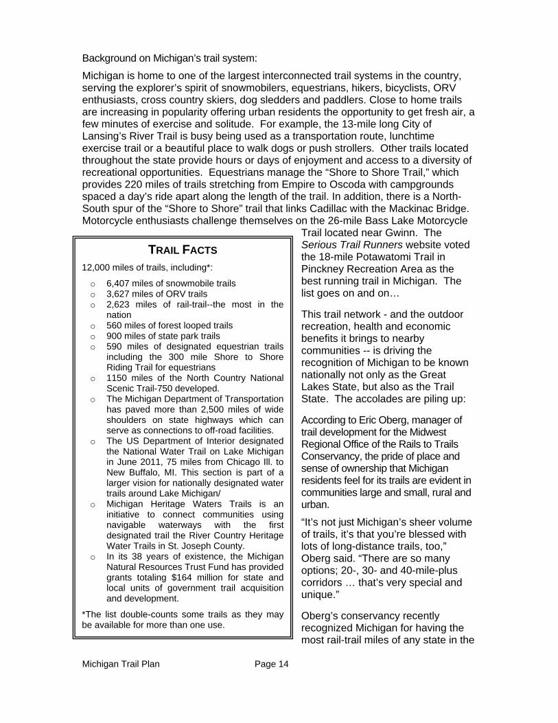
TRAIL FACTS 12,000 miles of trails, including*:
o 6,407 miles of snowmobile trails o 3,627 miles of ORV trails o 2,623 miles of rail-trail--the most in the
nation o 560 miles of forest looped trails o 900 miles of state park trails o 590 miles of designated equestrian trails
including the 300 mile Shore to Shore Riding Trail for equestrians
o 1150 miles of the North Country National Scenic Trail-750 developed.
o The Michigan Department of Transportation has paved more than 2,500 miles of wide shoulders on state highways which can serve as connections to off-road facilities.
o The US Department of Interior designated the National Water Trail on Lake Michigan in June 2011, 75 miles from Chicago Ill. to New Buffalo, MI. This section is part of a larger vision for nationally designated water trails around Lake Michigan/
o Michigan Heritage Waters Trails is an initiative to connect communities using navigable waterways with the first designated trail the River Country Heritage Water Trails in St. Joseph County.
o In its 38 years of existence, the Michigan Natural Resources Trust Fund has provided grants totaling $164 million for state and local units of government trail acquisition and development.
*The list double-counts some trails as they may be available for more than one use.
Michigan Trail Plan Page 15
nation, edging out Minnesota and Pennsylvania. He said that Michigan has “been at the forefront of rail-trail development, from the very beginning.”
Mountain bike trails in the Keweenaw area were recently recognized as one of seven International Mountain Biking Association “Ride Centers” as well as an IMBA Epic Ride in October of 2009 because of the 25-mile mountain bike trail system featuring 20 single track trails and a 600-700 foot elevation change. The recognition includes not only the heart pounding trail system, but the amenities provided in the surrounding area. The Bell's Beer Iceman Cometh Challenge in the northwest Lower Peninsula is widely regarded as the premier mountain bike event in the Midwest and is the largest single day race in the country. Sanctioned by USA Cycling, The Bell's Beer Iceman Cometh Challenge boasts a $52,000 cash purse with $30,000 reserved for professional cyclists. In 2012 participants came from 32 states.
In 2008, the North Central Trail, stretching from Gaylord to Mackinaw City, was ranked as one of the top five “Trails for Autumn” by the Rails to Trails Conservancy and was designated a National Recreation Trail in June 2012 by the US Department of Interior.
The Michigander was selected as one of the top 10 multi-day rides in the country by Bicycling Magazine.
Drummond Island was honored by BFGoodrich® Tires as one of the 2010 Outstanding Trails. BFGoodrich Tires, working in conjunction with Tread Lightly!® and United Four Wheel Drive Associations, chose the Drummond Island trail system because of its beauty and the challenge that it presents to off-road enthusiasts. The Drummond Island trail system offers more than 115 miles of trail laid out in a closed loop system and provides a wide range of riding opportunities.
UP Snowmobiling.com claims that snowmobiling in the Upper Peninsula is rated the “Best” in the nation year after year. One of the best known snowmobile trails is the Bill Nichols rail-trail that links Houghton to Mass City, a distance of 41 miles on the former Copper Range Railroad grade. The grade crosses the branches of the Firesteel River with 3 bridges that are 65, 75, & 85 feet high.
Trails are not only important for fun, relaxation and fitness, they are also important as a driver for local and regional economies; they enhance a community’s sense of place,
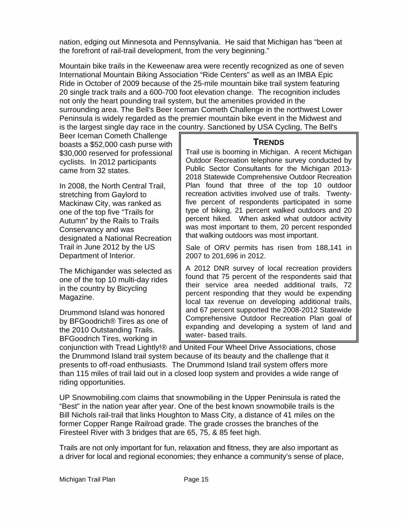
TRENDS Trail use is booming in Michigan. A recent Michigan Outdoor Recreation telephone survey conducted by Public Sector Consultants for the Michigan 2013-2018 Statewide Comprehensive Outdoor Recreation Plan found that three of the top 10 outdoor recreation activities involved use of trails. Twenty-five percent of respondents participated in some type of biking, 21 percent walked outdoors and 20 percent hiked. When asked what outdoor activity was most important to them, 20 percent responded that walking outdoors was most important.
Sale of ORV permits has risen from 188,141 in 2007 to 201,696 in 2012.
A 2012 DNR survey of local recreation providers found that 75 percent of the respondents said that their service area needed additional trails, 72 percent responding that they would be expending local tax revenue on developing additional trails, and 67 percent supported the 2008-2012 Statewide Comprehensive Outdoor Recreation Plan goal of expanding and developing a system of land and water- based trails.
Michigan Trail Plan Page 16
and increase property values. Trails have the potential to create jobs, grow local business (Barthlow and Moore, 1998), enhance property values (Adelaja et al., 2007), and provide positive health, recreational and spiritual benefits, especially for adjacent landowners (Sjoquist, 2003).
Michigan residents indicated in a March 2009 survey by Michigan State University Institute for Public Policy and Social Research (State of the State Survey 2022-51) that trails and parks were ranked sixth in importance in driving the state’s economic recovery behind the auto industry, renewable energy, agriculture, tourism and attracting people from other states.
Almost 70 percent of the respondents surveyed about the Pere Marquette Trail in Midland County and the Fred Meijer White Pine Trail in Kent County reported that the trails increased their community’s pride, and 67 percent in Midland County and 57 percent in Kent County indicated that the trails were important to community revitalization.
In 2006, the week-long Michigander bike ride reported that the typical traveling party (average of two people) spent $393 on food, gas, lodging, and souvenirs.
(Kaplanidou)
In February 1998, Michigan State University completed an assessment for the DNR of snowmobiling’s impact in the state of Michigan. That survey showed that the average snowmobiler in Michigan spent $4,218 annually on snowmobiling activity, equipment and vacationing in Michigan, which generated over $1 billion in economic impact in the state. At that time, over 6,455 full- time jobs were created by snowmobiling in Michigan.
A similar study, Michigan Licensed ORV Use and Users-2010, analyzed the economic significance of
ORV use in Michigan on public lands during a 12-month period in 2008–09. The study estimated economic contributions of equipment purchases and trip spending for this time period.
The study estimated that during that 12 month period, $212 million was spent on ORV equipment, repairs, insurance and storage in Michigan, and $82 million was spent on ORV-related trips.
Direct and secondary effects of ORV use on Michigan’s economy were also analyzed for trip-related spending. As those dollars “rippled” through the economy, the total effect of ORV-related spending was estimated at almost $98 million in sales, generating 800 jobs and more than $31 million in labor income. Total value added (essentially revenue less expenses) was over $54 million.
The ETS 2011 Recommendations Report, using a Michigan State University study (Wolf, et. al, 2006) estimated that there is approximately $351 million in direct and secondary economic impact generated by equestrian trail riders in Michigan annually.
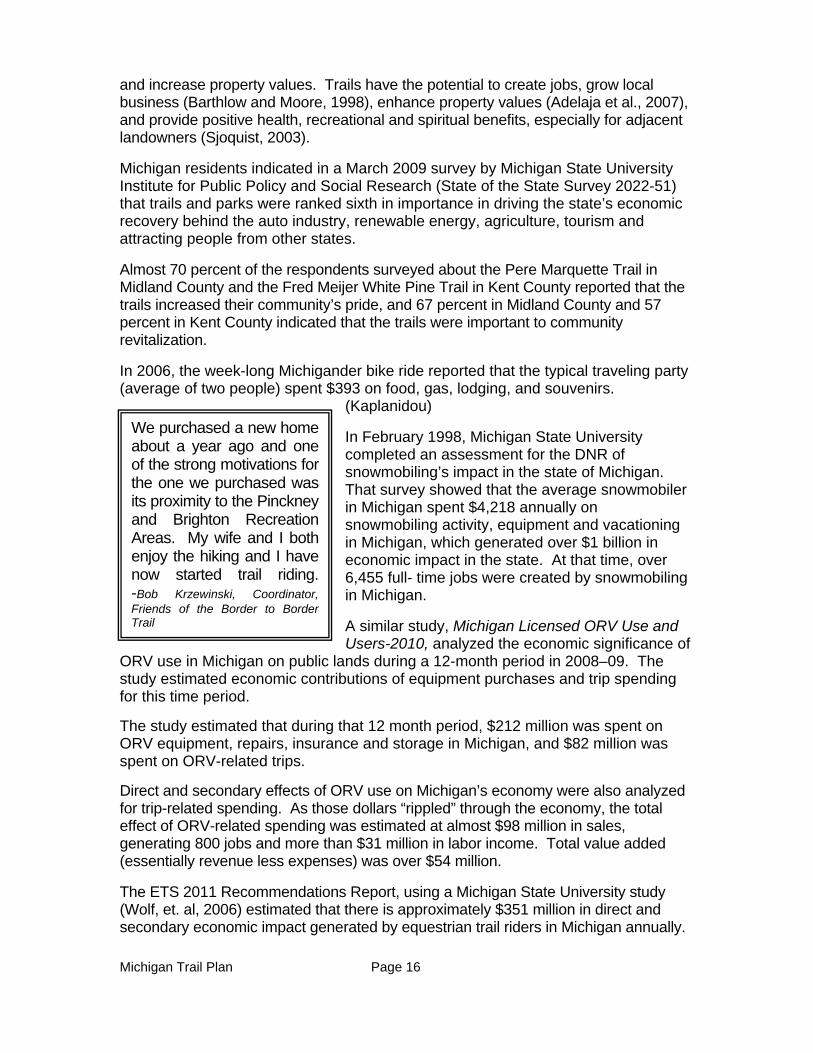
We purchased a new home about a year ago and one of the strong motivations for the one we purchased was its proximity to the Pinckney and Brighton Recreation Areas. My wife and I both enjoy the hiking and I have now started trail riding. -Bob Krzewinski, Coordinator, Friends of the Border to Border Trail
Michigan Trail Plan Page 17
It is easy to get lost in numbers and studies about trails and the impact on their communities, but throughout the state, businesses and local units of governments tell compelling stories that put these numbers and studies into perspective.
Jim Conboy, an avid Michigan trail user and member of the Top of Michigan Trails Council, has long been involved with advocating for the North Central State Trail, a 62-mile rail-trail that stretches from Gaylord to Mackinaw City.
“The North Central State Trail has brought nearby communities together like nothing else has. They are pulling together to promote the trail, and that initial face-to-face contact is spreading to other collaborative approaches.” Conboy said.
Bob Ulrich has a similar story. He retired in 2000, moved to Cheboygan County, and immediately “got bit” by the snowmobile bug. As a member of the Inland Lakes Snowmobile Club, he has been enjoying the sport ever since.
Ulrich believes the network of snowmobile trails in Michigan is “outstanding because of the care that went into the planning and, now, the grooming by the clubs.” That strong network means more riders come to Michigan, and that is great for local business.
“Snowmobilers need three things besides the snow. First, they need gas; second, they need to eat; and, finally, a place to stay while on their trip. Local businesses reap the financial benefits from snowmobiling,” he said. “In fact, many depend on us during the winter months to keep their businesses in the black.”
With an amazing variety of trails to choose from, Michigan residents can utilize the network as an easy and inviting way to keep themselves physically “in the black,” too.
Nancy Krupiarz, Executive Director of the Michigan Trails and Greenways Alliance, has seen many instances of trail-related health turnarounds. She shared a story about a couple of young women who joined a walking program held on the Kalamazoo River Valley Trail and, through persistent effort, lost a substantial amount of weight. The two felt so empowered, she said, that they sought out other ways to make personal improvements and, eventually, each enrolled in college for the first time.
Michigan Trail Plan Page 18
Dr. Joshua Meyerson, medical director for the Health Department of Northwest Michigan, is himself a trail convert. Dr. Meyerson said he had always driven to and from work and just decided one day to start biking, using the trail near his house to make the 19-mile trek. Once mostly sedentary, the doctor said his trail use led to his being “very much in shape” and eating better, too.
“Trails are an excellent way to promote healthy living through recreation,” he said. “They offer an alternative way of commuting to work or school, and I see lots of people riding bikes and pushing strollers… and just families out on the trails.”
History of Trails
Historically, trails have been the means to connect man to places that they want or need to go. Water trails and routes bordering the Great Lakes brought the first French explorers
to the great waters of Michigan. The explorers followed the paths of the Native Americans as they searched for pelts. Native American trails also became the routes for the state’s first roads, moving the military, commerce, settlers and freedom-seeking slaves across the Lower Peninsula. Railroads later created connections between internal settlements, thus allowing Michigan’s population and economy to grow. These abandoned railroad corridors now form Michigan’s rail-trail system that is enjoyed by snowmobilers, hikers, equestrians and bikers, and that brings economic prosperity to adjoining communities. Michigan’s long fascination with all things motorized extends to snowmobiles and ORVs. State and local governments partnering with motorized enthusiasts created the state’s world class snowmobile and the growing ORV trail system. Michigan’s trail system provides connections between communities, but also connects citizens and guests to Michigan’s spectacular natural resources.
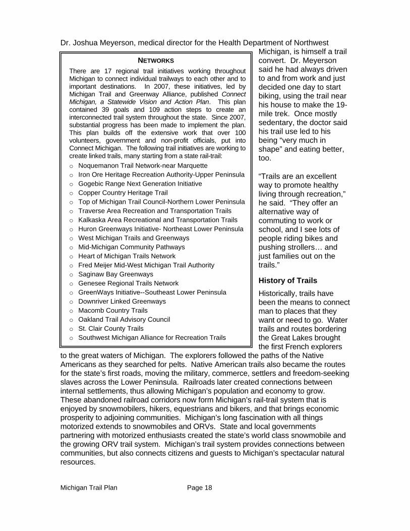
NETWORKS
There are 17 regional trail initiatives working throughout Michigan to connect individual trailways to each other and to important destinations. In 2007, these initiatives, led by Michigan Trail and Greenway Alliance, published Connect Michigan, a Statewide Vision and Action Plan. This plan contained 39 goals and 109 action steps to create an interconnected trail system throughout the state. Since 2007, substantial progress has been made to implement the plan. This plan builds off the extensive work that over 100 volunteers, government and non-profit officials, put into Connect Michigan. The following trail initiatives are working to create linked trails, many starting from a state rail-trail:
o Noquemanon Trail Network-near Marquette o Iron Ore Heritage Recreation Authority-Upper Peninsula o Gogebic Range Next Generation Initiative o Copper Country Heritage Trail o Top of Michigan Trail Council-Northern Lower Peninsula o Traverse Area Recreation and Transportation Trails o Kalkaska Area Recreational and Transportation Trails o Huron Greenways Initiative- Northeast Lower Peninsula o West Michigan Trails and Greenways o Mid-Michigan Community Pathways o Heart of Michigan Trails Network o Fred Meijer Mid-West Michigan Trail Authority o Saginaw Bay Greenways o Genesee Regional Trails Network o GreenWays Initiative--Southeast Lower Peninsula o Downriver Linked Greenways o Macomb Country Trails o Oakland Trail Advisory Council o St. Clair County Trails o Southwest Michigan Alliance for Recreation Trails
Michigan Trail Plan Page 19
Funding of Trails
Different funding sources are available for motorized versus non-motorized trail.
Motorized trail enthusiasts pay for the total acquisition costs of their trail corridors and the development, enforcement and maintenance of trails. As explained in more detail in the Motorized Trail Chapter (Chapter 3), snowmobilers are required to pay for registering their vehicle and to purchase a trail permit if they intend on riding trails. ORV riders are required to license their vehicle. Most of the development and maintenance of snowmobile and ORV trails are accomplished by local clubs through contracts with the DNR which provides grants for these activities. Motorized trails are available for use by non-motorized trail users that do not assist in paying the cost of development and maintenance.
The Michigan Natural Resources Trust Fund has been critical for the acquisition and development of non-motorized trail acquisition and development, especially linear trails. Much of the linear trail development has been assisted by Federal highway transportation funds. Local units of government, foundation and private contributions have also been critical for the acquisition, development and maintenance of many of the linear trails. Most other non-motorized trails, such as cross country ski, hiking, mountain bike, and equestrian trails have been developed on state-owned lands with assistance from the Recreation Improvement Fund or state park revenues. These trails are also often developed and maintained by user groups. Currently a Recreation Passport is required to on a vehicle that accesses non-motorized trails in state parks or recreation areas. Some trailhead parking lots in state forests also now require a Recreation Passport to be on parked vehicles. A portion of the Recreation Passport revenues are available for trail development or maintenance.
STATE FUNDS
The following list of funds has been used for the development and/or maintenance of trails and will continue to be an important revenue source for trails. All of the listed recreationally related state funds are constitutionally protected under Article 9 Section 40 of the Michigan Constitution.
PA 452 of 1994, Part 19- Michigan Natural Resources Trust Fund
The Michigan Natural Resources Trust Fund is available for the acquisition of land and development of recreation facilities. The Michigan Natural Resources Trust Fund has funded $164 million in state and local trail-related projects in its 38 years of existence.
PA 451 of 1994, Part 711 - Recreation Improvement Fund
Dedicated revenues from the state gas tax are used for maintenance and development of recreation trails. Approximately two percent of the funds allocated annually to the Recreation Improvement Fund must be used to restore damage caused by the use of ORVs.
Michigan Trail Plan Page 20
PA 451 of 1994, Part 741 - State Parks
Revenues from the sale of Recreation Passports, out-of-state day use passes, camping, and other revenues can be used for the acquisition of land and the development, maintenance and operation of recreational facilities within state parks or facilities where a Recreation Passport is required.
PA 451 of 1994, Part 741-Local Public Recreation Facility Fund
The Local Public Recreation Facility Fund generated from the sale of the Recreation Passport can be used for the development of local recreation facilities, including trails.
PA 451 of 1994, Part 781 - Waterways
The revenue from boat registrations and the sale of fuel deposited into the Waterways Fund can be used to develop, maintain and operate access sites that could be part of a water trail.
PA 451 of 1994, Part 811 – Off-Road Vehicles
Revenues collected from the sale of off-road vehicle licenses can be used for signage, maintenance, construction, leasing of lands to provide recreational opportunities for off-road vehicles, ORV law enforcement, restoration of environmental damage caused by ORVs and required ORV safety education.
PA 451 of 1994, Part 821 - Snowmobiles
Revenues collected from the sale of snowmobile trail permits and snowmobile registrations can be used for signage, maintenance, construction, equipment, law enforcement, and purchasing or leasing of land to provide recreational opportunities for snowmobiles.
PA 451 of 1994, Part 831 - State Forest Recreation
The State Forest Recreation Account can be used for the development, operation, maintenance and promotion of state forest recreation activities.
PA 51 of 1951, Section 10k funds - State Transportation Funds (MTF)
All agencies receiving funds from Act 51 shall spend a minimum of one percent of their MTF (averaged over 10 years) on non-motorized transportation facilities and services. This money can only be used for construction and not for operation or maintenance and includes funding for sideways, shared-use paths, bike lanes and associated pavement marking.
Michigan Trail Plan Page 21
FEDERAL FUNDS
23 USC 206 - Recreational Trails Program (RTP)
Dedicated revenues from federal gas tax used for maintenance and development of recreation trails. Funds must be distributed to project types that meet an allocation formula identified in the legislation; 30 percent motorized, 30 percent non-motorized and 40 percent diversified use. Additionally, the program requires an advisory board made up of trail users to meet every fiscal year to provide guidance on the program.
Moving Ahead for Progress in the 21st Century Act (MAP-21)
MAP-21 extends the federal-aid highway program and authorized funding for the Recreational Trails Program (RTP) as a set aside of the new Transportation Alternatives Program (TAP). MAP-21 also amends the Surface Transportation Program (STP) to allow any projects eligible under the RTP to be eligible for STP funds.
CMAQ - Congestion Mitigation and Air Quality
A program of MAP 21, it provides funding for trails, shared-use paths and bike lanes in areas of non-attainment for air quality.
Land and Water Conservation Fund
The Land and Water Conservation Fund provides funding for the acquisition of land and the development or renovation of outdoor recreation facilities.
Cost to Develop and Maintain Trails by Trail Type
The following chart provides information on the cost to develop and maintain trails. The information comes from a variety of sources. Costs vary depending on whether the land is currently owned by the developing agency, volunteers are used in the project, the type of material used for surfacing the trail and whether there is a need for bridges, culverts or boardwalks and other factors.
COST TO DEVELOP AND MAINTAIN TRAILS
TRAIL TYPE MILE OF DEVELOPMENT MILE OF MAINTENANCE
Snowmobile $5,000-$200,000* $350 per mile per season
ORV $5,000-$200,000* $61 per mile-less than 50 inches wide
$46 per mile-72 inches wide
Paved Rail-Trail $185,000-$250,000 $1,000-$13,000**
Un-paved Rail-Trail $45-$70,000 $1,000-$13,000**
Mountain Biking Trail $5,000-$26,000 $100-$4,000
Equestrian $1,000-$3,000 $300-$500
Walking $1,000-$3,000 $300-$500
Michigan Trail Plan Page 22
Water Trail less than $1,000 less than $1,000***
* Cost depends on whether the route is owned by the state and whether culverts, bridges, and other high cost items are required to be built for the trail
** Cost depends on if the trail is maintained by volunteers or paid staff, and the goals for trail and amenity quality ***It is expected that most of the MI water trail system could be developed using existing access sites. Costs would be for marketing, mapping, signage, handicapped accessibility, amenities.
Michigan Trail Plan Page 23
Limitations on the Use of State Land
There are many sources of funding that are used to purchase state land for public purposes. All funding sources carry some criteria as to how the land can be utilized. Three primary sources of funding that include restrictions with respect to trail-related recreation on the acquired lands are: (1) Pittman Robertson Wildlife Restoration Funds (PR), (2) Dingell Johnson Sport Fish Restoration Fund (DJ) and (3) License Fee Acquired Lands (LF).
PR/DJ Grant Acquired and Managed Lands: DNR lands which are PR/DJ acquired and/or managed are distributed in a checker board pattern across the state. Many of these areas are desirable to a variety of recreation users. Trail use is not prohibited on PR/DJ purchased land. However, when it does occur, the intensity and frequency cannot interfere with the primary purpose of hunting and fishing. For example, PR/DJ funds cannot be used for enforcement of use restrictions or other non-PR/DJ purposes on PR/DJ lands. As an example, should the US Fish and Wildlife Service determine that the state is not adequately managing the frequency and intensity of EQ use on these lands and if a satisfactory resolution is not achieved, future PR/DJ funding is jeopardized. Since these funds have been significant-$23.5 million in 2012-careful management of non-hunting and non-fishing activities is very important.
License Fee Acquired and Managed Lands: Some DNR lands were acquired and/or are managed with hunting and fishing license fees. A provision of the PR (1937) and DJ (1950) Acts is that states must assent to only use state license fees for fish and wildlife services. Michigan assented in 1939. The state acceptance of these provisions is found in Section 324.40501 of the Natural Resources and Environmental Protection Act 451 of 1994 where it states “…funds accruing to this state from license fees paid for by hunters shall not be used for any purpose other than game and fish activities under the administration of the DNR.” The DNR complies with the law by only allowing for trails that support fish and wildlife purposes.
DNR Trail Planning Process
The DNR manages state-owned lands in a manner that protects and enhances the public trust while providing for the use and enjoyment of those lands as required in the Natural Resources and Environmental Protection Act. In order to do so, the DNR as public land managers must understand and manage the impacts of any development on the lands under its management control. The department has been balancing uses of the land for many decades and recognizes the need for adaptive management as use and intensity of uses change.
Careful management decisions have allowed a world-class trail system to be developed on state land, as well as campgrounds, access sites, timber management to maintain healthy forests, management to maintain healthy wildlife populations, oil, gas and mineral extraction, opportunities for solitude and quiet experiences, and many other uses and values.
Michigan Trail Plan Page 24
The DNR has several internal processes for evaluating the proposed development of a new trail. The process varies depending on whether the proposed trail is located in a state park/recreation area or elsewhere on state land. These processes assist in determining whether the trail will be compatible with existing management plans; verifying that sensitive natural or cultural resources are not adversely impacted; ensuring forest certification requirements are met; and avoiding user conflicts on trails or in other types of recreational experience.
In the State Forest and in wildlife areas, recreational trail proposals are evaluated using the DNR’s State Forest Land Resource Assessment Activities Procedure. The procedure for State Parks/Recreation Areas has not been promulgated. The Department is currently merging these processes.
The DNR welcomes proposals from the public on new trail opportunities. To provide for a transparent nomination process, the DNR will post the DNR trail nomination form and application requirements on its website. This nomination form will trigger the appropriate internal department review.
Michigan Trail Plan Page 25
CHAPTER 2 - RECOMMENDATIONS AND ACTIONS
PRIORITY: ENSURE A SUSTAINABLE TRAIL SYSTEM BY MAINTAINING TRAILS TO
ESTABLISHED GUIDELINES.
Why this Priority?
Maintaining a high quality trail system is critical to ensure that Michigan fosters its reputation as The Trail State. Ongoing maintenance of trails is also important for safety, minimizing capital outlay costs and protecting environmental integrity. The public spends their limited recreation time and resources on facilities that meet their expectations. When a trail is rutted, filled with downed trees, lacking directional signs or is poorly groomed, citizens go elsewhere to play, including out of state. The 2013-2017 Statewide Comprehensive Outdoor Recreation Plan focus group participants repeatedly emphasized that the state should ensure that existing facilities are maintained in a quality fashion before the construction of new facilities.
The most important consideration for trail maintenance is whether or not a trail was initially built correctly. Many trails were never designed or constructed for the type or amount of use that they currently receive and may require major redevelopment to reduce long-term maintenance costs.
Key actions to implement this priority:
In order to provide a quality trail system, all trails shall be maintained to meet maintenance guidelines reviewed and recommended for adoption by MSTAC. In order to meet this action, existing national standards developed for different trail types should be considered by MSTAC for adoption.
For grant-maintained trails, failure to meet maintenance guidelines should result in immediate correction, and, if not corrected, potential revocation of the maintenance grant.
Reimbursement rates for snowmobile trail maintenance should be re-evaluated on a regular basis to ensure adequate support for desired trail maintenance levels.
Fees that support trail programs should be regularly adjusted to reflect current development and maintenance costs.
Standardized yearly maintenance plans that recognize the type, use and challenge being offered by a trail should be developed and implemented for all trail types. All DNR- maintained trails should be inspected annually based upon maintenance plans.
Explore and address impediments to volunteer organizations providing maintenance of DNR trails.
Utilize the Civilian Conservation Corp (if re-created) to provide maintenance activities on all trail types.

Michigan Trail Plan Page 26
How Success will be Measured
In the MDNR/MSTAC 2012 Trail User Survey that was conducted to inform this plan, 8.4 percent of the respondents indicated that their trail use declined because of the quality of the trails. MSTAC will consider this priority recommendation successful if the percentage of survey participants is reduced from 8.4 to 5 percent in the subsequent trail survey.
Michigan Trail Plan Page 27
PRIORITY: EXPAND TRAILS, TRAIL EXPERIENCES AND OPPORTUNITIES TO
ENSURE ACCESS TO TRAIL SYSTEMS, OUTDOOR RECREATION AND MICHIGAN’S
TREASURED NATURAL AND CULTURAL RESOURCES.
Why this Priority?
While the trail system should be maintained to guidelines that ensure quality experiences and retain existing trail users, the system must also expand to provide new opportunities, experiences and access to recreational opportunities such as hunting, fishing, trapping, kayaking, etc. There are certain trail experiences, for example water trails, where there are abundant opportunities but minimal work has been accomplished toward designating such trails. Significant opportunities also exist to interpret Michigan’s natural and cultural resources along trail corridors to provide enhanced experiences and promote place-making. “Designating” a trail helps to provide the trail user with confidence that amenities appropriate to the trail are available including signage, restrooms, trail parking facilities, and overnight accommodations if appropriate.
The Midwest states account for 22% of all rail-trails and 32% of all rail-trail miles in the country. The Canadian province of Ontario has more rail-trails and rail trail mileage than any other Canadian province. Developers of the Trans-Canada Trail have planned routes to Windsor and Sault Ste. Marie Canada. These facts point to the opportunity to not only continue to develop trail opportunities within the state but also to link with opportunities in other states and in Canada.
Trail planners and developers should also recognize the importance of networks and ease of access, including access that meets ADA standards. Trails in urban settings need to be planned and designed to minimize dependence on access via a motorized vehicle and to ensure a sense of safety. They should provide access between neighborhoods and community services. ORV trails should be designed so that a full loop can be ridden without interruptions. Trails should be designed recognizing how far the public is willing to drive for that recreational activity. For example, the Michigan 2013-2017 Outdoor Recreation Citizen Survey found that people who liked to walk outdoors were only willing to drive a half-hour for that activity, so walking trails need to be available at the community level. The trail user survey recently conducted by the DNR in preparation for this plan found that 54 percent of snowmobilers were willing to travel six hours or more to participate in their sport, including 12 percent that indicated they were willing to travel 11 hours or more to snowmobile trails. So snowmobile trails are not required in all communities. Similarly, 33% of equestrians were willing to travel six hours or more, including 11 percent willing to travel 11 hours or more.
Having a looped or linked system is important for all trail users and future investments in trails should be made with this in mind. The trail user survey found that a looped trail was “extremely” or “very important” for all types of trail users.
Users of trails have multiple reasons why they pursue their trail sport, whether it is to promote a healthy lifestyle or to enjoy Michigan’s spectacular natural resources. Expansion of Michigan’s trail system should recognize trail users’ interests and
Michigan Trail Plan Page 28
needs and also ensure the protection of resources to ensure sustainability of the system.
Key Actions to Implement this Priority:
Identify critical gaps in the existing regional trail networks, work to address those gaps and strive for a seamless system. Gaps may include lack of diversity of experiences.
Meet ADA requirement for trail expansions as appropriate.
Assure compatibility of trail expansions on state-owned lands with other values and programs associated with the land.
Include access to trails in local and regional transportation plans.
Develop and coordinate implementation plans for priority trails, trail linkages and critical gaps in cooperation with federal, state, local government, other states, Canadian provinces, and the private and nonprofit sectors. Planning should also occur between program areas of the DNR.
Increase the number of trails as identified in this plan.
Provide interpretive opportunities as appropriate on all trail types.
Identify opportunities for developing heritage and other cultural trails.
Strive to keep up with current trends in trail management, design and operation.
How Success will be Measured:
Three critical linkages in the linear trail system are completed within five years.
Michigan Trail Plan Page 29
PRIORITY: THE MICHIGAN SNOWMOBILE AND TRAILS ADVISORY COUNCIL
(MSTAC) LEADS THE EFFORT TO MAINTAIN AND ENHANCE MICHIGAN’S
REPUTATION AS THE TRAIL STATE.
Why this Priority?
Enhancing Michigan’s reputation as The Trail State will occur with the continued cooperation and collaboration of trail organizations and steady, guiding leadership. The MSTAC is the organization to provide that leadership as its membership reflects all of the major trail user groups and its legal charge to “advise the governor and the Department of Natural Resources in the creation, development, operation, and maintenance of motorized and non-motorized trails in this state” provides it the authority and credibility to implement the vision.
Key Actions to Implement this Priority:
MSTAC should establish criteria for identifying and funding priority gaps and connections that also recognize opportunities that arise unexpectedly.
MSTAC should work with trail and other government organizations to convene a biennial trail summit.
MSTAC should create a process for anticipating and mediating conflicts among trail users.
MSTAC should track progress in implementing this trail plan utilizing an adaptive management approach by reviewing identified outcomes and metrics and determining changes to the plan, key recommendations and key actions based upon collected data.
MSTAC should regularly survey trail users to identify priorities and progress.
We are blessed to have so many open trails that the public can use. They are an inspiration and inspire many of us older runners and hikers to get out there and see nature and get some fresh country air in our lungs. I have been involved in the Old Farts Running Club for about the past six years and I have seen first-hand how these trails have touched the lives of so many runners throughout our state and our nation. Since the OFRC has been putting on some trail- runs through these woods there have been dramatic impacts throughout this region. There have been runners from over 33 states and even other countries like Japan, England, Iceland and Canada that have come to Lowell, Michigan just to run on these trails. The economic impact of bringing in so many out of town runners has no doubt made a huge impact on all aspects of our economy and none of this would have been possible without these trails.
-Old Farts Running Club

Michigan Trail Plan Page 30
MSTAC should appoint a subcommittee that includes representatives from transportation, utility companies, economic development, health, and tourism that can advise MSTAC and the advisory workgroups in their work.
MSTAC should strive to build linkages between the Comprehensive Trail Plan and all other land management plans to ensure compatibility with use and vision.
How Success will be Measured:
MSTAC will measure success by the completion of all of the key actions within five years.
Michigan Trail Plan Page 31
PRIORITY: LINK TRAILS, TRAIL USERS AND ADJOINING TOWNS TO CREATE
MEMORABLE TRAIL EXPERIENCES AND ENHANCE LOCAL PROSPERITY
Why this Priority?
Trails, trail users and the trails adjoining towns should be linked to ensure that trail users have the amenities that they need for memorable trail experiences and so adjoining towns will realize the potential of trails to drive local economic growth.
The Prospect Foundation in Pennsylvania understood this important relationship and developed the Trail Town Program® to provide trail users the needed services along the Great Allegheny Passage (Passage), and in turn support community revitalization in the adjoining trail towns. The program provides tools, research and low- interest loans to communities adjoining the Passage to grow their businesses and provide trail users with an enhanced experience. The program also works to address trail-wide issues and opportunities through regional cooperation and to create safe connections between the trail and adjoining communities. The Trail Town Program® has documented its value through the growth of new trailside related businesses and an increase in trail use.
Communities associated with the North Central State Trail in the northern Lower Peninsula wanted the same results as the trail towns along the Passage. The towns bordering the North Central State Trail developed a tool kit on how communities can maximize the economic benefit of the trail and a strategy for amenities that the communities would provide to maximize use of the trail. “Instead of letting economic development happen by chance, the Towns to Trails Initiative encourages the development of trails and the business that they bring to the local towns,” stated Harry Burkholder, a planner involved in the North Central Trail Town effort. “By involving and communicating with the local jurisdictions, chambers of commerce, trail advocates, and recreation and economic planning divisions of these towns, all parties can benefit from trails and their users.”
The Trail Town Program®
partnered with the Laurel Highlands Visitors Bureau and the Allegheny Trail Alliance on an economic impact study of the trail from 2007-2009. As part of the study, businesses and trail users were surveyed. It was found that the trail generated annual spending of $40 million a year.
On average, business owners indicated that more than one-quarter of their gross revenue was directly attributed to trail users and two-thirds responded that they experienced at least some increase in gross revenue because of the proximity to the trail. --- The Great Allegheny Passage Economic Impact Study 2007-2008, August 7, 2009, Campus, Inc.
“The North Central State Trail and the North Eastern State Trail have brought the communities along them together like nothing has before. They are pulling together to promote the trails and that initial face to face contact is spreading to other collaborative approaches.- Jim Conboy, Board Member of Top of Michigan Trails Council
Michigan Trail Plan Page 32
This community collaboration related to trails should be replicated throughout the state. The following actions are recommended to ensure that Michigan cities, villages and towns maximize the economic benefits of Michigan’s extensive trail system and the use of trails by visitors and citizens.
Key Actions to Implement this Priority:
Designate a position within the DNR’s Parks and Recreation Division to work with local units of government to create linkages between department-managed trails and adjoining local units of government.
The DNR should create a toolkit to help communities understand how to capitalize on their local trails to grow their area’s economy.
Organize a biennial trail town conference in conjunction with the MSTAC, the Michigan Municipal League, Michigan Townships Association, Michigan Association of Counties, and other partner trail organizations including state agencies. The purpose of the conference would be to share best management practices, encourage other towns to become engaged with their adjoining trails, market Michigan’s trail system, and present relevant survey information.
The MSTAC and the DNR should create a recognition program for trail towns and trail businesses and use the biennial conference to deliver that recognition.
Create an evaluation mechanism to document how the trails contribute to the economic prosperity of towns that adopt the “trail town” initiative.
Change DNR policy relating to signs to allow for directional signs to adjoining towns. Policy should allow for signage similar to MDOT’s Tourist Oriented Direction Signs which provide for standardized signs that advertise local businesses.
The DNR should fast track local unit of government requests to develop amenities associated with trails, including trailhead parking lots, trailside parks, benches, bathrooms and drinking water on state land.
How Success will be Measured:
Economic impact study of a regional trail that implements a trail town program documents increased economic growth generated by the program.
Michigan Trail Plan Page 33
PRIORITY: DEVELOP, ENHANCE AND CELEBRATE PARTNERSHIPS AND
COLLABORATIONS TO ACQUIRE, DEVELOP AND MAINTAIN TRAILS AND TRAIL
CONNECTIONS.
Why this Priority?
The quality and quantity of Michigan’s spectacular trail system is due to the partnerships that have collaborated to acquire, develop and maintain the trails in the system. Federal, state, local units, county and regional governments, non-profits, foundations, user advocacy organizations and individuals have invested in creating and maintaining Michigan’s trail system. It is a unique arrangement which has allowed exponential growth of the system by addressing impediments such as funding in innovative ways. For example, in Michigan, volunteers have contributed 23,781 hours valued at $518,188 to maintain the North Country National Scenic Trail (US Department of Interior, National Park Service). By recognizing a shared mission, federal, state, local units, nonprofits and individuals have focused on collaboration rather than individual accomplishments and the system is a testament to the success
of this way of doing business.
Currently there are 17 regional trail initiatives that are developing networks of rail-trails. In most cases, the projects have a state-acquired rail-trail as the trunk of the system with branches providing connections to communities and other recreation facilities. The snowmobile program has grown and prospered due to the partnership between the DNR and local snowmobile organizations that develop, maintain and groom Michigan’s renowned snowmobile trail system. Michigan’s equestrian community is justifiably proud of the Shore to Shore Trail that they maintain, stretching from Empire to Oscoda and from Cadillac to the Mackinac Bridge, with the trail and related campgrounds on state, private or federally- owned lands. The continued maintenance and future growth of the system is dependent on these partnerships.
“The Inland Lakes Snowmobile Club is a big supporter of the Indian River Grooming Club, both financially and with manpower for trail brushing and also installing and maintaining trail signs. Because our club members actively use the network of groomed trails here in Michigan, we all appreciate the work the DNR continues to do to keep our trails open and safe.” -The Inland Lakes Snowmobile Club
The new Burt Lake Trail, when complete, will be an 18-mile east/west connector between the North Central State Trail and the Northwestern State Trail. Thanks to Burt Township, the Cheboygan County Road Commission, local residents and the Top of Michigan Trails Council, the first phase will be ready for area residents and visitors to bike and hike in 2013. The first phase is funded by a Transportation Enhancement Grant of $473,325 from the Michigan Department of Transportation, a grant of $398,500 from the Michigan Natural Resources Trust Fund and $140,000 in private contributions to fulfill the required local match. Major donations were received from the Burt Lake Preservation Association, the Tri-County Bicycle Association DALMAC Fund, the Petoskey-Harbor Springs Area Community Foundation, hospitals of northern Michigan, and more than 120 individual donors.
Michigan Trail Plan Page 34
What should be celebrated is the role that volunteers have played in the development and maintenance of the trail system. The snowmobile trail system is almost entirely maintained by volunteers, many of the cross country ski trails are groomed by volunteers, mountain bike trails have been constructed and are being maintained by volunteers, “friends organizations” are maintaining trails in many state parks, and the Shore to Shore equestrian trail was developed and is being maintained by volunteers. Trail users are passionate about their trail sport and are willing to put their time, energy and resources to providing opportunities. Michigan would not be The Trail State without the investment that volunteers have made in the trail system.
Key Actions to Implement this Priority:
Implement a standardized application and memorandum of understanding process for DNR “friends” organizations to assist in the development and maintenance of trail facilities.
With MSTAC taking the lead, identify critical linkages, trail expansions and trail development needs and create a development plan with partners and collaborators to meet that need.
Maximize the use of volunteer organizations to provide maintenance of state trails by eliminating obstacles and streamlining the process.
Recognize and support regional trail organizations’ efforts to promote trails.
DNR, MSTAC, Michigan Natural Resources Trust Fund, Michigan Economic Development Corporation, Michigan Department of Agriculture and Rural Development and Michigan Department of Transportation shall align and prioritize their efforts to support and create trail connections.
Improve the trail review process within the DNR and make the process transparent to the public.
Trail partners should collaborate with the public health community to promote the use of trails for physical and mental health.
How Success will be Measured:
Completion of three priority linkages within five years secured through collaborations.
Increase the percentage of trails built and maintained in partnership by 5 percent annually.
Michigan Trail Plan Page 35
PRIORITY: CREATE AND IMPLEMENT A STATEWIDE MARKETING PLAN THAT
ENGAGES RESIDENTS AND GUESTS IN THE STATE’S VAST ARRAY OF TRAIL
OPPORTUNITIES.
Why this Priority?
The key to enhancing Michigan’s reputation as The Trail State is to create and implement a robust marketing program to ensure that residents and guests are fully aware of the vast array of trail opportunities and related amenities that are available in this state. No other state has the array and extent of opportunities that are available in Michigan, but comprehensive information about the system is difficult to locate. For trail users who travel to participate in their sport, there is no convenient way to plan their trip or receive assistance in matching opportunities with supporting amenities. Currently, trail users cannot find out the difficulty of trails, what other users they might find on the trail, or other necessary information to allow for the trail experience that meets their needs and expectations. The need for a more robust marketing program and an online information source is also a priority of the Governor’s Blue Ribbon Recreation and Parks Commission and the Michigan 2013-2017 Statewide Comprehensive Outdoor Recreation Plan.
Key Actions to Implement this Priority:
DNR working with Pure Michigan and trail partners should create a marketing program, brand and logo for the state’s trail system.
DNR should provide marketing support for state and partner organizations.
Trail partners should all work to obtain national exposure for Michigan’s trail system.
Trail partnership should create social media tools to promote trails, trail use and the multiple benefits of trails.
DNR and MSTAC should create a robust education and outreach effort to help minimize conflicts and promote safety.
DNR, Pure Michigan and trail partners should create an online portal that allows a trail user to identify trails and related amenities in their area or plan where they wish to visit. All trails should be listed and the portal should include an “open source database” so that local communities can utilize the data to drive local economies.
The DNR should take the lead in identifying and coordinating all trail marketing efforts to ensure maximum effectiveness and efficiency.
How Success will be Measured:
MSTAC will demonstrate marketing success when the percentage of people that indicate on the yearly use survey that they get their information about trails from the DNR website increases from nine to 12 percent.
Michigan Trail Plan Page 36
PRIORITY: DEVELOP FUNDING SOURCES AND MECHANISMS FOR TRAIL
MAINTENANCE AND FILL FUNDING GAPS FOR ACQUISITION AND DEVELOPMENT.
Why this Priority?
The Michigan Natural Resources Trust Fund is available to acquire property for trails and to assist in the development of trails. Federal transportation dollars have also been successfully used for the development of trails. With the Michigan Natural Resources Trust Fund reaching its constitutional cap there are reduced dollars available for trail development and acquisition. Federal dollars have also been reduced by approximately one-third in the past year. In addition, there are very limited sources of revenue for trail maintenance, which is vital to retaining and growing the user base, and in turn is ultimately vital for local communities. Michigan will not retain its national prominence as The Trail State without additional state funding for all trail types.
Funding for trails is currently determined by the type of use. ORV and snowmobile trail users pay the full costs for acquiring easements, developing and maintaining their trail system. Non-motorized trail users do not have a sustainable source of funding even though demands for all types of non-motorized trails are increasing.
Key Actions to Implement this Priority:
The DNR and trail partners should compile the cost of maintaining trails to guidelines, operating state-owned trails and acquiring and developing priority linkages in order to determine revenue needs compared to available revenues. Once this analysis is completed, the Department shall work with MSTAC and trail partners to identify means to address funding needs including fees for non-motorized use similar to the fees associated with motorized use.
The DNR should create a guide to assist local governments and nonprofits in financing the acquisition, development and maintenance of trails.
Maximize and leverage, to the fullest extent possible, existing funding sources to address priorities.
Transition the Recreation Passport to an “opt out” program when people register their vehicles. Earmark a portion of that revenue stream for trail maintenance.
The DNR and trail partners should actively seek and recruit corporate sponsors from the recreation industry to invest in recreational trails.
Eighty percent of the 4,000 plus respondents to the Trail Survey conducted for this report replied that they would be willing to pay for trail maintenance on an annual basis, similar to ORV and snowmobile riders.

Michigan Trail Plan Page 37
Create a mechanism whereby funds (federal, state, local, private and non-profit) can be pooled and dedicated for the purpose of acquisition, development, maintenance, and operation of multi-use trails corridors. A financial incentive should be developed property owners who permit a portion of their property to be used for a trail.
How Success will be Measured:
Adequate funding meets annual maintenance needs on all trail types.
Michigan Trail Plan Page 38
PRIORITY: ENSURE THAT THE STATE’S TRAIL SYSTEM COMPLIMENTS OTHER
PLANS AND PLANNING EFFORTS, CONSERVES THE RESOURCES THAT ENHANCE
THE SYSTEM, AND IS COMPATIBLE WITH THE OTHER VALUES AND PROGRAMS
ASSOCIATED WITH THE LAND.
Why this Priority?
Public lands in Michigan are managed for multiple values and multiple stakeholders including wildlife, timber, water quality, oil and gas, and many other forms of recreation. State parks and recreation areas have general management plans that guide the development and management of park facilities including trails. The state forests are certified as being managed sustainably (as required by law) by two different certifying agencies. These certifications require state forests to adhere to management plans and to conserve the resource integrity of the forest. Existing plans also manage recreation, resource protection, public use for state wildlife areas, the Pigeon River Country State Forest, designated environmental areas, etc. How the state land was acquired also dictates the use of the land. For example, land acquired with game and fish license funds can only be used for wildlife purposes. The DNR has and will continue to manage its portion of the state trail system in balance with these plans and land acquisition and management funding sources. The DNR and its trail partners have created this world class trail system in concert with its other land management priorities and plans.
As part of the balancing process, the state also strives to develop and manage trails to conserve the resources that make the experience enjoyable and unique. Other considerations in that balancing process are managing the number and location of trails so that conflicts are reduced, quiet and solitude are maintained as appropriate, sensitive areas are protected, and the trail use experience is of high quality. While a priority of this plan is to develop new trails, this development must be managed to protect both the experience and other values.
Key Actions to Implement this Priority:
Trail development and maintenance must be compatible and consistent with other state land management plans
The trail proposal and approval process should be made transparent so that the public understands the DNR process for evaluating new trail proposals and the considerations in that process.
The DNR should work proactively with stakeholders to address emerging trail trends and user needs to ensure consistency with land management plans and resource conservation needs.
Trail marketing efforts should promote the “leave no trace” ethic to support the sustainability of the trail system.
Interpretation of the natural and cultural resources and land management activities should be planned as part of all new trail development.
How Success will be measured:
No audit findings regarding trails in the forest certification annual review or other audits of state land management practices.
Michigan Trail Plan Page 39
CHAPTER 3 - MOTORIZED TRAIL SYSTEM
OFF-ROAD VEHICLE TRAIL SYSTEM
Background
Statutory regulation of off-road vehicles (ORVs) began in Michigan with PA 319 of 1975. The Act required the DNR to develop a comprehensive plan for the management of ORV use of areas, forest roads and forest trails, under the jurisdiction of the DNR.
In compliance with Act 319, the DNR published the first ORV plan in 1979 that provided recommendations in three areas:
Minimize social conflict
Meet outdoor recreation needs
Protect environmental integrity by confining ORV use on state public lands to the state forest roads, and a system of designated ORV trails, routes and areas.
Growing concern about natural resource damage caused by ORV use precipitated the passage of PA 17 of 1991 which restricted the use of ORVs on public lands in the Lower Peninsula to only designated trails, routes and areas. In the Upper Peninsula, state forest roads and designated trails remained opened to ORVs, unless posted closed.
ORV Plan Process
In the spring of 2004, the DNR initiated, with the assistance of Michigan State University, a public planning process to update the 1979 ORV Plan and assess program needs from a variety of perspectives, from land managers to trail riders. In August 2005, MSU submitted the draft plan based on public input to the DNR. The MSU plan included 44 specific recommendations grouped into eight topic areas. The plan was adopted by the ORV Advisory Committee and DNR Director Humphries in 2008. Recommendations were targeted to the following eight areas:
1. Designated ORV Trail System
2. System Maintenance
3. Enduro Motorcycle Events
4. Program Administration
5. Damage Restoration
6. Law Enforcement
7. Safety Education
8. Licensing
Michigan Trail Plan Page 40
Forest Certification and Other Plan Influences
PA 124 of 2004 required that state forest lands be certified under at least one forest certification program by January 2006, in order to demonstrate sustainable forestry management and keep Michigan’s timber a marketable commodity. The certification process overlapped the ORV plan review process and public comment period. In December 2005, a corrective action request (CAR) was issued by the Forest Stewardship Council and Sustainable Forestry Initiative forest certification auditors to address illegal ORV use on state forest lands. An ORV Task Force was appointed and charged to propose a strategy to address the CAR and illegal ORV use in three areas: user education, law enforcement, and restoration/maintenance of damaged lands. The task force completed its charge in June 2006, and submitted several recommendations.
These recommendations were supported by the DNR and submitted to the forest certification auditors at the 2007 annual surveillance audit. The auditors found that the recommendations adequately addressed their request to develop a strategy to reduce or eliminate illegal ORV use, and considered the CAR completed. The auditors then established a new CAR (CAR 2007.4) which required the DNR to incorporate and implement the recommendations into the ORV Management Plan.
In addition, PA 154 of 2005, Section 807, was enacted and required the DNR to submit a comprehensive plan to expand the current ORV trail mileage by at least 25 percent, or 796 miles, over the next four years. The Section 807 report was issued in June 2006 and focused on upgrades of the existing designated ORV system to meet maintenance standards. It also cited several opportunities for growth beyond the traditional boundaries of the state forests and onto lands managed by local units of government or the private sector. Trail advocates were identified as a crucial element in the success of this initiative for trail expansion.
In 2006, the DNR was receiving increased pressure to allow counties to designate their roads open to ORVs in the Upper Peninsula and northern Lower Peninsula. The DNR requested and received a letter of guidance from the Office of the Attorney General that precipitated a response from the legislature with a bill that would address the issues raised in the letter, and provide the counties with broader authority to designate roads open to ORVs. The bill passed the House unanimously but was not taken up by the Senate. The DNR followed up with a letter to all county road commissions, encouraging them to work the DNR in formally designating ORV routes and trails that would connect the state designated ORV motorized trail system with local communities and services.
The updated management plan which guides the maintenance and development of the ORV system is included in Appendix 2.
Existing System
Michigan is nationally known for its extensive off-road vehicle (ORV) trail system. The 3,627 miles of designated trail routes and 2,198 acres of scramble areas are located throughout the state on state and federally owned forest lands and more recently on private lands. The system has expanded almost 20 percent since 1996.
Within Michigan's designated trail system, 24 percent of the trails are designated and
Michigan Trail Plan Page 41
maintained for motorcycle use only, 50 percent are designated for motorcycles and all-terrain vehicles (ATVs) and 24 percent are designated as ORV routes - open to ORVs of all sizes, including trucks, motorcycles and ATVs.
In addition to the designated ORV trail and route system, thousands of miles of state and National Forest roads in the Upper Peninsula are open to operation of ORVs.
Designated ORV scramble areas include the Black Mountain Scramble Area in Cheboygan County, St. Helen Motorsport Area in Roscommon County, Bull Gap Hill Climb in Oscoda County, Silver Lake State Park in Oceana County and the Mounds ORV Park in Genesee County.
Michigan's ORV trail program is funded exclusively from ORV licenses fees. An ORV license is required when an ORV is operated on public trails, roads, designated scramble areas and frozen public waters. The fund is protected by the state constitution and may be used only to pay for trail maintenance, new trail development, law enforcement, safety education, and restoration of damage caused by illegal ORV use on public lands. A small percentage also is set aside for administration of the program.
The Michigan ORV trail maintenance program is carried out by 34 nonprofit clubs and public agencies that receive grants from the DNR. These trail sponsors are responsible for grooming, signing and brushing the trails.
The DNR spends approximately $1.6 million each year on the maintenance of existing designated trails. In addition, the DNR annually spends about $400,000 on restoring damage caused by illegal ORV use.
To help riders better understand what is and is not safe and responsible riding the DNR has published The Handbook of Michigan Off-Road Vehicle Laws, which is available from DNR Operations Service Centers and most ORV dealers. The publication also may be found online at www.offroad-ed.com/mi/handbook/laws.htm.
To assist ORV riders even further, the DNR has improved the quality and availability of ORV maps, which can be accessed on the DNR's website at http://www.michigan.gov/dnr under Recreation, Camping & Boating. These maps accurately represent the current trail system and will help riders to stay on the trails.
Vision of what a quality system would look like:
ORV trail system is expanded or enhanced to provide riding opportunities at a variety of levels of challenge for all ORV user groups to further enhance tourism in the state.
The existing trails, routes and use-areas are consistently maintained to guidelines and the approved sign plan is implemented across the entire trail system. Bridges and culverts are replaced to address safety and environmental impacts.
The DNR provides recognized leadership and oversight to facilitate the program.
Annual trail condition and trail maintenance compliance inspections are conducted in a thorough manner.
Michigan Trail Plan Page 42
Enforcement presence by conservation officers and contracted law enforcement assistance is increased by 25 to 30 percent.
The public has easy to access information about trails, trail conditions and related amenities.
A permanent designated trail network is in place through the acquisition of permanent easements.
The program is recognized for being a safe recreation experience with all riders receiving safety education.
Opportunities – Gaps, Regional Needs
Trail Development Priorities:
Construct a route running parallel to the Michigan Cross Country Cycle Trail (MCCCT) in the Lower Peninsula for all types of ORVs including side-by-sides that are increasing in popularity, and a similar route in the Upper Peninsula extending from Wisconsin to Drummond Island.
The DNR and ORV stakeholders will identify and develop an interconnected ORV route system in the Lower Peninsula that utilizes existing state forest roads, county roads and new trails to provide enhanced opportunities and increased connectivity between trails and communities while minimizing conflicts with other users, environmental damage and safety concerns.
Construct two routes in the Lower Peninsula extending from the central Lower Peninsula to Mackinac City on the east and west sides and a loop going completely around the Upper Peninsula.
Identify and/or develop ORV connectors open to ORVs of all types between towns, trails or other points of interest. Connector routes can aid in developing an interconnecting ORV trail system. Connectors may include segments of state designated ORV routes or other dirt, gravel or paved corridors where local ordinances and special conditions allow for ORV use. Some examples of potential connectors include State Forest, county, USFS and corporate timber company roads that are open to ORVs and permission has been obtained to sign as an ORV connector and routes and/or trails located on private land where permission has been secured.
Develop with local trail sponsors and the US Forest Service a trail marker that identifies ORV connector routes. Identifying ORV connector routes is important for point-to-point or destination type riding. Providing a consistent trail marker for an interconnecting ORV route system would provide the following benefits:
o Opportunities to create trail maps that users could reference to reach their destination.
o Inform users that they are on a route open to ORVs.
o Reduce user confusion by providing a single consistent trail marker.
o Reduction in unwanted and unlawful use of ORVs.
o Bring ORV routes into economically depressed communities.
Michigan Trail Plan Page 43
Opportunities for Related Business Development
This is directly correlated to trail development and expansion. As the trail system grows more opportunities for business development will occur.
Business Opportunities Include:
Near-to-trail repair facilities
ORV sales facilities
ORV Touring Packages- with ORV rentals
ORV tour guides
Near- to-trail restaurants and lodging facilities
ORV rentals
Opportunities for Private Sector Involvement and Partnership:
Identify ways for local units of government and partners to assist in achieving the goals outlined in the plan.
Research other states to see what is working to attract the ORV tourist.
Have representatives from the DNR involved with national and international organizations such as the National Off-Highway Vehicle Conservation Council and the International Association of Off-Highway Vehicle Administrator’s Association to gain a better understanding of industry and trail rider trends and how other states are addressing/managing these changes.
Collaborate with ORV manufacturers on potential funding sources outside of the funds generated by ORV sticker sales and to stay informed on industry trends.
Threats & Challenges
Funding
Additional revenue to the ORV program fund is necessary in order to appropriately maintain and grow the system, address ORV damage, provide adequate enforcement, achieve the management plan objectives and fulfill regional needs. The additional 25 percent increase in the amount of trail called for in recent law (necessitating private land owner leases in some cases) exacerbates the revenue problem. User groups are currently in support of increased fees.
Land Use Conflict
Expansion of the system is challenged by a number of issues including potential restrictions on the lands caused by funding source used to acquire the ORV trail/route and the need to manage lands sustainably under Forest Certification. In addition, there is an interest by the ORV community to expand ORV use onto snowmobile trails which would potentially require new leased easements. Approximately 50 percent of the snowmobile trail easements are leased and at this point the leases provide for use only by snowmobilers. Willingness by lessors to expand the leased easements to ORV needs to be explored.
Michigan Trail Plan Page 44
User Conflict
Conflicts occur between motorized users as well as between motorized and non-motorized trail users. While there will always be user conflicts, the most effective approach is to address conflicts as they occur by people located as close to the conflict as possible.
Industry Changes
The ORV industry has constantly changed over the past 40 years bringing new products to market before there is the recreational infrastructure to support the product. This lack of infrastructure causes user conflicts, unmet user expectations and further strains limited resources. The ORV industry should assist in addressing this threat.
Oversight
Limited revenues have also limited the staff devoted to administering the program, managing the trails, providing appropriate law enforcement and ensuring appropriate oversight to limit resource damage. The ORV plan calls for increased law enforcement activity by 25 to 35 percent. Due to limited staff, there is greater reliance on grant recipients and trail users to report issues, problems and potential problems.
Trail Expansion
Expansion of the system and providing connections to communities and other trails will be challenging because of the need to obtain trail easements from private landowners. Changes in legislation may be necessary to address trail connectivity issues including allowing ORV use of certain MDOT right- of- ways, state assumption of risk as currently provided to snowmobile clubs by the state; and to increase ORV registration fees.
Priorities/Goals (five-year)
Continue to implement the 2008 ORV Management Plan.
Design new trails with safety as a primary concern.
Increase user fees to support ORV trail development and maintenance needs and to provide for increased safety training and law enforcement. An inflationary escalator should be included in any new fee authorization.
Regularly review training programs for effectiveness.
As outlined in this chapter, continue trail expansion as funding becomes available.
Explore and address issues related to expanding the trail system to private lands.
Construct and manage trails to DNR/industry guidelines to control environmental impacts while seeking common sense solutions to allowable impact.
Develop new ORV trail facilities in the southern portion of the state.
Michigan Trail Plan Page 45
SNOWMOBILE TRAIL SYSTEM
Background
Existing System & Current Funding
Before 1968, Michigan had between 200 and 300 miles of scattered loop trails. The passage of PA 74, 1968 championed the creation of the current Michigan snowmobile program. This law requires that a registration sticker be placed on each snowmobile that is operated in the State of Michigan. A portion of the revenues collected from registrations are deposited into the Snowmobile Trail Improvement Fund (STIF). These funds have been used to construct and maintain many of the existing 6,500 miles of snowmobile trails. Amendments to the act in 2008 removed registration dollars from the STIF fund. As the number of registered snowmobiles fluctuated so did the amount of funding available for trail development, maintenance and management purposes. This fluctuating revenue precipitated the need to stabilize revenue sources and, in 1987, the Recreation Improvement Fund Act (RIF) was signed into law. The law allocates two percent of the state gasoline tax revenues into the RIF fund (the amount of gas tax generated by recreational vehicles off roads) and of that amount, not less than 14 percent of RIF funds are deposited into the Snowmobile Trail Improvement Fund (STIF). As a further means of providing adequate funding for the system, legislation was passed in 1994 requiring all snowmobiles which are operated off private lands to have a snowmobile trail permit. A portion of the revenues from these permits are deposited into STIF. STIF is used to construct and maintain trails. Current projected annual income from all sources into the Snowmobile Trail Improvement Fund is approximately $9.4 million.
Today, Michigan has over 6,500 miles of marked, well-groomed public snowmobile trails throughout the state. These trails are maintained by snowmobile clubs, business groups, chambers of commerce or a combination thereof and are called “grant sponsors.” The snowmobile community is proud of the role it has played in the creation, maintenance and continued success of the snowmobile trail system. Beyond their actual volunteer labor efforts on the trails, organized snowmobilers have worked with government officials at the local, state, and federal levels in a variety of ways and have been instrumental in the enactment of numerous pieces of legislation which collectively have created the current snowmobile trail program.
A goal of the program has always been to ensure that the trails are connected, creating a network stretching across the snow-belt areas of the state. This network permits snowmobilers to travel hundreds and even thousands of miles across many different areas of the state. The trails are developed on lands owned by the private sector (50 percent of the trails) and state and federal lands (each with 25 percent of the trails) . They are an important part of the social and economic fabric of Michigan.
Technological improvements in snowmobiles
A number of significant improvements have been made in snowmobile technology since the time when many of the snowmobile trails and facilities were first developed. Improvements in the suspension system, engine power, fuel efficiency, windshield effectiveness and overall reliability have resulted in snowmobiles with
Michigan Trail Plan Page 46
increased comfort, acceleration, and top speeds. These improvements have also allowed snowmobilers to travel for increased periods of time on trips that cover longer distances at higher speeds while getting optimum fuel mileage. While these improvements may have kept much of the snowmobiling public active in the sport and aided in the recruitment of new participants they have also contributed to serious management challenges. For example, in the mid-1990s Michigan annually recorded approximately 45 snowmobile fatalities. Accidents on snowmobile trails accounted for 25 percent of these fatalities. Snowmobile safety and zero tolerance programs, tougher Driving Under the Influence (DUI) laws and better-maintained trails have led to snowmobile fatalities being reduced by 50 percent.
Current System
Over 6,500 miles of groomed snowmobile trails.
Over 230,000 registered snowmobiles.
164,000 Michigan snowmobile trail permits were sold for the 2010-2011 winter season.
78 percent of snowmobiling days in Michigan were primarily spent on the trail system.
Thousands of snowmobilers visit from other states and Canadian provinces.
Snowmobiling generated $2 million in Michigan state gasoline taxes in the winter of the 2010-2011.
The total economic activity associated with snowmobile trip spending in Michigan is $500 million in income and about 6,455 jobs.
Current Management Strategy
The Parks and Recreation Division (PRD) of the DNR is responsible for the management of the Michigan snowmobile trail system. As a part of this responsibility, the PRD coordinates and oversees the Recreational and Snowmobile Trail Grants Program. The purpose of the grants program is to provide financial assistance to local units of government; nonprofit incorporated snowmobile clubs and associations and other nonprofit, incorporated organizations for the development and maintenance of snowmobile trails and areas. The entire trail system is maintained by grant sponsors.
Trail maintenance occurs year around and is segmented into normal and special maintenance operations. Normal maintenance operations include annual trail brushing, and signing efforts. These activities are currently reimbursed at $90/mile/season. Special maintenance projects are also eligible for funding. These projects include: bridges, bridge repair to decking and railings, bridge beltings, culverts and washout repairs, beaver dam removals, gates for private landowners, removing hazardous trees, stumping, grading and new trail development including heavy brushing, culverts, and bulldozing to build up the trail.
The grooming of snowmobile trails is paid at a rate of $5.13 per mile when trail grooming actually takes place during the 16 week operational season. The rate of reimbursement is determined each year on December 1and again on April 15 based
Michigan Trail Plan Page 47
upon a number of variables, including fuel oil and lubrication prices, equipment parts and machine maintenance time.
In order to promote the Michigan snowmobile trail system, the DNR publishes and distributes snowmobile trail maps on line at www.michigan.gov/snowmobiling.
Partnerships
The success of the Michigan snowmobile trail system is due to the partnerships/collaborations that have been developed between the grant sponsors and the state and federal governments, private organizations, and individuals.
A total of 68 grant sponsors actively groom and maintain the trails. This occurs during snow and non-snow seasons. Funds are allocated and paid to the grant sponsors on a reimbursement basis, through a formal agreement between the grant sponsor and the DNR. Funds are available for development of new snowmobile trails and areas; maintenance of existing trails and areas, which includes grooming, signing and trail brushing; leases, easements or permits for snowmobile trails on private lands; groomer comprehensive/collision insurance and trail liability insurance.
The Michigan Snowmobile Association, convention and visitor bureaus, chambers of commerce, regional tourism organizations, snowmobile clubs and councils are also important partners in the snowmobile program. These organizations provide information to potential trail users concerning trail opportunities, snow conditions and detailed snowmobile trail riding maps.
The Ottawa, Hiawatha, and Huron-Manistee National Forests all permit snowmobiling. In the Huron Manistee National Forest snowmobiles are not allowed off designated snowmobile trails or on unplowed roads unless designated. However, they do not groom any trails. They have been very cooperative in working with grant sponsors in the planning, layout and construction of groomed trails located within their boundaries. Also, many thousands of miles of un-groomed roads are open to snowmobiling within the National Forests. Snowmobile trail mileage on National Forest land totals approximately 1,600 miles or 25 percent of the statewide system.
The DNR Parks and Recreation Division administers 101 State Parks and Recreation Areas. Thirty-two of these parks, recreation areas and state park linear trails, comprising almost 84,000 acres, are open to snowmobiling when a minimum of four inches of snow has accumulated.
Snowmobile Advisory Workgroup
The Snowmobile Advisory Workgroup, a sub-committee of the Michigan Snowmobile and Trails Advisory Committee (MSTAC) consists of seven members appointed by the chair of the MSTAC. The Snowmobile Advisory Workgroup advises the DNR regarding:
the development of criteria for safety education
the allocation of funds from the Recreational Snowmobile Trail Improvement Fund
Michigan Trail Plan Page 48
the promulgation of rules affecting snowmobile use in Michigan
the development of annual updates to the comprehensive plan for implementing a statewide recreational and snowmobile trail system
implementation of the recommendations made by snowmobile users regarding trails that should be designated for snowmobile use
the development of a comprehensive plan for the use of snowmobiles in Michigan.
Enforcement
The DNR Law Enforcement Division has the primary responsibility for the enforcement of snowmobile laws on state lands. They also administer a statewide safety and education training program. The division receives funding from registration revenues to finance law enforcement efforts. In addition, county sheriff departments receive grants to aid in the enforcement of laws pertaining to snowmobiling.
Marketing
The marketing of a service, such as the snowmobile trail system, entails a coordinated effort to strategically price, promote, plan and deliver a final product or service to the users. The Michigan Snowmobile Trail System currently has all of the necessary components.
Price: The state charges $30 for a three-year registration sticker, this money is used for law enforcement and to purchase easements for a permanent trail system. In addition, a yearly $45 trail permit is required if the snowmobile is to be operated off private lands. The money from this permit is used to fund the operation of the snowmobile program.
Promotion: The DNR publishes and distributes maps of the snowmobile trail system. Information is also available on the DNR website at www.michigan.gov/snowmobiling.
The Michigan Snowmobile Association, local chambers of commerce, visitor and tourism bureau and many clubs also promote and provide maps of all the snowmobile trail areas at www.msasnow.org.
Planning: The Snowmobile Trail Program is in the ongoing process of planning for the development and maintenance of the trail system.
Product/Service: The current 6,500 miles of trail, and numerous trailheads are the final product which the program provides to its users.
Current Funding Distribution System
PA 451 of 1994 mandates snowmobiles to have a $30 snowmobile registration sticker. Registration fees are deposited into the Snowmobile Registration Fee subaccount where they are then moved to the appropriate account.
Michigan Trail Plan Page 49
In 1987, the Michigan Legislature passed the Recreation Improvement Fund, Act, PA 221 of 1987. Under the act, two percent of the state gasoline tax is allocated to the RIF and of that amount, not less than 14 percent of RIF funds are deposited into the Snowmobile Trail Improvement Fund.
PA 99 of 1994 was enacted to provide adequate funding for the system. This legislation requires that all snowmobiles which are operated on public lands possess a $45 trail permit. Of these revenues, $43.53 is deposited into the Michigan Snowmobile Trail Improvement Fund.
More recently, PA 371 of 2010 created the "Historic Snowmobile Registration," a one-time fee of $50 for snowmobiles 26 years and older.
SNOWMOBILE FEE BREAKDOWN
Michigan Snowmobile Registration Decal $30 (3 Year)
$3 Secretary of State
$19 Law Enforcement (DNR & Sheriff Grants)
$8 Permanent Snowmobile Trail Fund (used to acquire permanent trail easements)
Michigan Snowmobile Trail Permit $45 per year
$43.53 Snowmobile Trail Improvement Fund (STIF)
$1 to selling agent
$ .47 Administration & Printing
Michigan Historic Snowmobile Registration $ 50 (one time)
$42 into Snowmobile Trail Improvement Fund (STIF)
$5 into Law Enforcement ( DNR & Sheriff Grants)
$ 5 Secretary of State
Recreation Improvement Fund (RIF)
14 percent of two percent of the total gas tax collected goes into Snowmobile Trail Improvement Fund
Projected annual income from all sources into the Snowmobile Trail Program is approximately $12 million. The following graph (Michigan Snowmobile Program Revenue Distribution Chart) details the distribution of revenue into the snowmobile program.
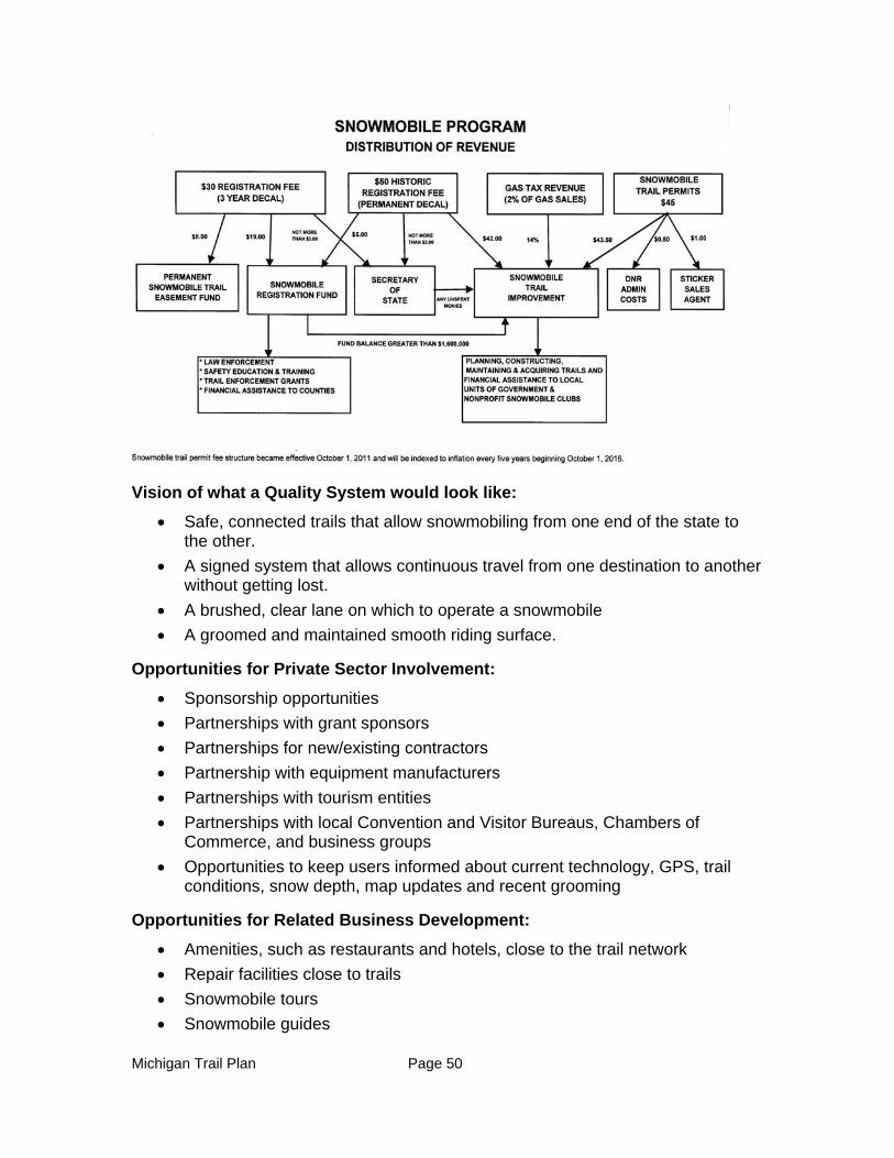
Michigan Trail Plan Page 50
Vision of what a Quality System would look like:
Safe, connected trails that allow snowmobiling from one end of the state to the other.
A signed system that allows continuous travel from one destination to another without getting lost.
A brushed, clear lane on which to operate a snowmobile
A groomed and maintained smooth riding surface.
Opportunities for Private Sector Involvement:
Sponsorship opportunities
Partnerships with grant sponsors
Partnerships for new/existing contractors
Partnership with equipment manufacturers
Partnerships with tourism entities
Partnerships with local Convention and Visitor Bureaus, Chambers of Commerce, and business groups
Opportunities to keep users informed about current technology, GPS, trail conditions, snow depth, map updates and recent grooming
Opportunities for Related Business Development:
Amenities, such as restaurants and hotels, close to the trail network
Repair facilities close to trails
Snowmobile tours
Snowmobile guides
Michigan Trail Plan Page 51
Promotional magazines and articles
Opportunities - Gaps, Regional Needs:
The current system is approximately 6,500 miles in length and provides thousands of miles of continuous riding. The current trail system is an interconnected network of looped trails, with connector trails running north, south, east and west. On this system of trails, a snowmobiler can begin their ride at the Michigan-Indiana border and travel to the Mackinac Bridge with only two trail interruptions. From here there are many alternative travel routes to the Michigan-Wisconsin border as well as routes to other states and Canada.
Priority Lower Peninsula Connections:
Connection of the Berrien trail # 182 to the Cass/Van Buren Trail # 590 or # 12
Connection between the North Allegan County Loop Trail # 59 and the White Pine Trail # 5 (Around Grand Rapids)
Connection of White Pine Trail # 5 to the Musketawa Trail # 19
Connection of the Musketawa Trail # 19 South to the Allegan Trail # 59
Connection of the Sanilac Trail # 20 to the North around the Bay
Connection of the Pere Marquette Trail # 30 East to the Bay Area
Connection of the Oceana Trail #191 East to the Newaygo Trail # 320
Connection from the Lake Trail # 3 or the Mason Trail # 6 into or near the town of Ludington
Connection of Trail # 30 before Clare North towards Trail # 657 Leota in Clare County
Connection of Trail # 69 and Trail # 489 in Roscommon and Crawford County and trails around Roscommon
Connection between Mesick to Copemish (on the state-owned rail grade)
Connection between Cadillac to Manton (Possibly along old 131 corridor)
Connection from Benzie Trail # 3 East to Trail # 510 in Grand Traverse County
Connection from Trail # 55 Kalkaska East to Trail # 76 Kalkaska County
Extend Benzie Trail # 3 North to the town of Lake Leelanau
Connect Trail # 4 from the Ellsworth area South to Central Lake, through Bellaire and then East to Mancelona
Connection between Trail # 7 and Trail # 9 along the Cheboygan/ Otsego County line, or Onaway to Indian River
Connection between Rogers City south to Trail # 992
Connection between Trail #4 and Trail #992 through the City of Alpena
Connection between Trail # 4 near Alpena and Trail # 996 Barton City
Priority Upper Peninsula Connections:
Michigan Trail Plan Page 52
Connection between Rudyard Trail # 472 and the Red Creek Bridge Trail # 47
Connection between Hulbert Trail # 474 and Newberry Trail # 45
Connection between Pike Lake Trail # 8 and Pine Lake Trail # 45
Connection between Trail # 33 west to Trail # 7 South of Alger County
Costs Associated with the Development of Additional Trail Mileage
In order to make informed decisions concerning the development of additional trail mileage, it is necessary to examine the monetary costs associated with developing and continually maintaining additional trail mileage. It should be noted that the following costs are very general and represent estimations of associated costs.
Annual Management Costs
Regular Maintenance
(Brushing and Signing) $ 580,000
(Grooming- 5 year average) $ 2,053,000
Special Maintenance $ 1,000,000
Insurance (Comprehensive/collision) $ 183,000
Insurance (Liability) $ 141,000
Snowplowing $ 192,000
Portable Toilets $ 58,000
Leases & ROW $ 215,317
Contingency $ 68,000
Groomer Utility $ 95,000
Signage and posts $ 250,000
Equipment Replacement $ Variable
Equipment Major Repair $ 400,000
Administration $ 1,400,000
Total $ 5,694,317
Michigan Trail Plan Page 53
One-Time Trail Development Costs
Trail Development, extensive brushing, construction Variable
Threats
Safety and Accidents
Over the last 10 years snowmobile groups have banded together to promote zero tolerance of alcohol when riding snowmobiles. The combination of a public relations campaign and stricter DUI laws has contributed to a reduction in alcohol-related accidents and fatalities. Snowmobile safety courses for kids and adults are now offered through the clubs and online courses are also becoming popular with adults. These courses have also contributed to encouraging safe riding habits.
Threats from Extreme Groups
In Michigan and nationally, there are groups that would like to see motorized recreation banned from state and National Forests. With science-based knowledge, the snowmobile groups have been able to keep access open to most lands.
Funding Concerns
The snowmobile grant sponsors receive 100 percent reimbursement for grooming tractors and drags. The cost of this equipment has rapidly increased and a lack of snow over the last several winters has taxed the system. Different rental, lease and trade-in programs are currently being looked at to address providing necessary equipment at affordable rates.
Planned increases in trail permit revenue have not occurred due to resistance by the legislature to pass the necessary legislative amendments.
Volunteer Concerns
In the beginning of the snowmobile trail program, the trails were relatively small, local looped systems that were very easy for volunteers to maintain. The local clubs were the primary users of these trails. As snowmobile- related tourism increased, this situation began to change. Due to grant sponsor’s efforts, increased funding, and leases for the use of private lands, the miles of maintained trail have also greatly increased. The increase in trail mileage has resulted in additional maintenance efforts. As trail mileage and funding have increased, the efforts required from grant sponsors to track and document the funds have increased greatly. This not only creates extra work for the volunteer sponsor organization, but it is considered a part of the club’s “administrative cost” and is therefore not a reimbursable expense. As the number of maintained miles has increased, so has the overall use of the trails. The number of available volunteers is decreasing while the workload is increasing. The snowmobile trail program has evolved into a major business enterprise, and in some areas it has become a struggle to manage and operate it as a volunteer-managed program. It now requires partnerships with businesses, other state departments and tourism-related businesses.
The Lack of a Permanent Trail System
Michigan Trail Plan Page 54
The Michigan snowmobile trail system is situated on the lands of local, state, and federal government agencies, as well as those of large and small private properties. Due to land use and user conflicts, these trails are constantly being rerouted. This rerouting results in wasting of time, money, and administrative resources of the DNR and grant program sponsors.
Trails on Privately-Owned Property
Approximately 50 percent of the current 6,500 mile trail system is located on privately- owned property. These properties range from relatively small privately-owned acreage to lands owned by large corporate landholders. The use of private lands for the development of the trail system is especially critical for the approximately 500 miles of trail which run between the City of Grand Rapids and the Michigan-Indiana border. Private lands are leased from landowners for the purpose of snowmobiling. Irresponsible/unsafe actions by a minority of snowmobilers result in the loss of some leases each year. In addition, when these private properties are sold the new owners may not be supportive of the system and may not renew existing leases. The above factors have created a constantly moving, temporary trail system.
Forest and State Road Issues
On state forest lands, the current definition of a forest road classifies all snowmobile trails, including new abandoned rail-trail acquisitions, as “forest roads.” As such, all snowmobile trails are open to all licensed vehicles, year round. Additionally, they are subject to being rerouted or closed if/when other users request plowed road access. In order to reduce maintenance costs, the Michigan Department of Transportation (MDOT) desires to remove trails that go over or under highway bridges. For safety reasons, the DNR opposes the removal of these over/under passes.
Overcrowding
While large numbers of snowmobilers are good for local, regional, and state economies, the increase in popularity has led to the overcrowding of the trail system. Certain areas of the state, especially in the UP, are so heavily used that around the clock grooming is inadequate to maintain the trails. Inadequate trail grooming as well as excessive use leads to rough trail surfaces. When this occurs, snowmobilers often leave the trails in search of a smoother riding surface. As a result snowmobilers may trespass on private property, ride into hazardous situations, or cause damage to environmentally sensitive areas. A need for parallel trails may be the answer to this problem.
Priorities/Goals (five years):
1. A complete interconnected trail system with adequate funding to maintain a smooth, safe riding experience.
2. Financial support from grant programs such as the Michigan Natural Resources Trust Fund, the National Recreation Trails Fund, and the MAP-21.
3. Increased compliance with the existing trail permit program.

Michigan Trail Plan Page 55
4. Costs of the trail system are shared with other users who benefit from the system.
5. Encourage and attract youthful involvement in the snowmobile program to enhance mentoring from experienced, knowledgeable, hardworking grant sponsors.
6. Trail placement is secure and constructed on permanent easements.
Priorities:
1. Increase patrols on the snowmobile trails and increase compliance of the trail permit system.
2. Increase fines for lack of trail permit.
3. Expand cost-shared expenses on multiple use trails and systems.
4. Stabilize the trail network by acquiring easements on private lands utilizing the Permanent Snowmobile Trail Fund.
5. Address equipment funding shortfalls.
6. Attract new members to grant sponsor organizations to continue the hard work of current grant sponsors and to gain valuable knowledge through mentoring.
7. Continue to match the program with available revenue which may require changes in equipment purchases, limit future enhancements to the program and cause possible retraction in the amount of new trails.
How to Sustain the System:
Weather is always a factor in snowmobiling. Poor snow seasons must be acknowledged and plans for funding shortfalls need to be established.
Promotion of the sport is critical for the system to sustain itself.
A young, healthy trail sponsor workforce is needed to carry on the work of the veteran, experienced and dedicated trail sponsors.
Encouragement and recruiting of new grant sponsors would help sustain the system into the future.

Michigan Trail Plan Page 56
Chapter 4 - Non-Motorized Trail System
LOOPED TRAILS
Background
Definition of Looped Trails
For purposes of this plan, “looped trails” are defined as regularly-maintained land-based trails that are designated and maintained for non-motorized uses including but not limited to: cross country skiing, bicycle riding, equestrian and hiking/running/snowshoeing. Looped trails generally have a single start and end point within a specific area (attached to a trailhead, campground or other significant feature) and offer a variety of lengths depending on the trail loops selected by the user.
Other types of non-motorized trails located on or off state lands in Michigan include long distance point-to-point trails such as the North Country National Scenic Trail, the Shore to Shore Riding and Hiking Trail and Midland to Mackinac Trail which are covered in the linear trail portion of this chapter Many looped trails and linear trails provide for recreational opportunities for multiple types of uses but there are also trails designed specifically for a single use, like mountain biking (i.e. VASA single track).
Existing System
Amazing looped trails exist throughout the state of Michigan that offer opportunities for fun, relaxation, exercise and experiencing nature. The DNR reports almost 1,600 miles of looped trails exist on state-managed lands, particularly within state parks and in state forests. This number doesn’t include the thousands of miles of trails that are available on federal lands, specialized trails such as the award-winning mountain bike system located in the Keweenaw Peninsula or in local jurisdictions.
Vision Statement for Looped Trails
Looped trails provide non-motorized opportunities to experience the outdoors along marked trail systems that provide access to unique scenic, natural features and/or historical areas. Looped trails also provide access to the state’s land holdings for various activities such as wildlife viewing, berry picking, mushrooming, hunting and fishing.
A quality statewide looped trail system would be:
An integrated system between State, Federal and local trail systems.
Fully funded for both construction and maintenance,
Constructed and maintained according to accepted, natural resource-based guidelines for the primary intended use but accommodating all non-motorized users (to the fullest extent practicable) including hikers, bicyclists, equestrians, and cross-country skiers.
Michigan Trail Plan Page 57
Properly signed including: way-finding/advance signage, trailhead signage, and confidence markers.
Promoted so that all necessary information to plan an outing is available including maps, elevations, mileage, acceptable uses, directions to the trailheads, level of challenge offered by the trail, current conditions (i.e. cross country ski grooming schedule and updates on snow conditions or special circumstances such as unique regulations).
Linked, where appropriate, to other looped trails, linear trails, other types of recreational facilities, and to local communities.
Permanent corridors are preserved when other uses of the state forest cause change in land management practices or forest cover.
Interpretive opportunities are provided along the trails to help explain natural resource management activities including timber harvesting, wildlife management or resource protection and cultural features.
A venue where community events such as races and nature study can occur with minimal DNR oversight.
Adopted by “Friends” organizations to help with maintenance, promotion, event planning and resource protection.
Developed and maintained for as many user groups as can be sustained on a given trail minimizing user conflicts and encouraging harmonious multiple uses.
Opportunities – Gaps, Regional Needs
Opportunities for maintaining and expanding the looped trail systems include:
1. Existing looped trail facilities need to be upgraded and maintained for year-round use. Needs include:
A budget for maintenance and improvements according to a master plan for each looped trail
Creating new “places” along the trails including interpretive signs, scenic cultural, or wildlife viewing areas and rest stops
Equipment sufficient to maintain trails
Upgraded signs, benches, mounting blocks and overlooks
Maintenance plans and maintenance schedules for each looped trail
A “friends” organization for each looped trail system to assist in addressing maintenance, promotion, conflict resolution and enforcement needs.
2. Manage use-expectations with comprehensive marketing and maps, including a web-based portal that has a comprehensive listing of looped trails and associated amenities. Maps should include:
Appropriate activities on a given looped trail (what it was designed for)
Difficulty ratings- Easy/Moderate/Difficult
Michigan Trail Plan Page 58
Length of trail/loops and expected hike/bike/ski time
Consistent mapping standards for all looped trails
Marketing of ethical use principles such as -“Leave No Trace”
3. Streamline and coordinate the existing trail proposal processes within the DNR.
4. Once the existing looped trail system is improved and the trail proposal process enhanced, then the opportunities to address looped trail “gaps” and regional needs can be carried out. Looped trail gaps, regional needs and opportunities are too numerous to mention but should be prioritized by the following criteria:
There is an interest in creating a “friends organizations” to help with trail maintenance and promotion.
The looped trail provides access to scenic beauty, water features, or other outstanding natural, historic or cultural resources.
The looped trail links to other recreational facilities, whether or not owned/ managed by the state.
The looped trail provides new recreational opportunities, addressing user conflict from over-use of a nearby looped trail or fills a needs gap.
The looped trail assists in enhancing local economic prosperity.
Opportunities for Related Business Development:
Business development is fostered by a quality, well-maintained non-motorized trail system. There are several actions that the state can take to foster business development related to looped trails including:
Utilizing DNR guidelines, allow adjacent and nearby businesses to develop connector trails and signage in order to maximize the economic potential of the trail.
Allow for vendors to provide services such as bike and ski rental near or at popular looped trails.
POTENTIAL LOOPED TRAIL EXPANSION The Grand Traverse Hiking Club has initiated a proposal to develop an 18 mile looped trail system in northern Wexford and southern Grand Traverse Counties. This trail would fill a backcountry/backpacking niche currently unavailable in the area. This proposed trail loop would encompass Old US-131, Spring Lake State Forest campgrounds, a MDOT roadside park and the Village of Fife Lake. The proposed trail is very scenic, utilizes existing amenities such as camping, and parking; provides increased revenue at two State Forest Campgrounds, and increases visitors to the Village of Fife Lake. The Grand Traverse Hiking Club has volunteered to “adopt” this proposed trail. Communication with MDOT regarding the use of highway right-of-way has been positive.
Michigan Trail Plan Page 59
Identify and assist in the development of connector routes from communities to looped trails. Work with public transportation providers to provide bike racks.
Work with local economic development agencies to develop lodging and other resources near trail facilities.
Create a marketing and branding program to increase the use of looped trails
Provide support and advice to businesses and communities as to how to take advantage of nearby trail use.
Opportunities for Private Sector Involvement:
Event planning including festivals and events on and around the looped trails.
Guiding visitors on looped trails.
Creating tours that provide multiple day opportunities utilizing looped trails, linear and water trails
Shuttle service to transport luggage and equipment between looped trails, to campgrounds or overnight accommodations
Trailside support and amenities – bicycle repair shops, restaurants and overnight lodging
Threats:
The biggest threat to the existing system is lack of maintenance. Many facilities are not regularly cleared or groomed. There is a significant need for infrastructure and maintenance on the existing facilities including consistent signage, map production, bridge/boardwalk repairs, trailhead development, mowing, grading, tread stabilization and the re-routing or development of new loops in order to protect the environment.
Priorities/Goals: (five -year)
All existing designated looped trails are improved and maintained to guidelines.
Amenities are provided on the trails to meet user needs including signage, benches, trailhead, and outhouses where necessary.
Looped trails are marketed and promoted so that Michigan citizens and visitors are aware of the vast system of looped trail opportunities.
Citizens and visitors can obtain looped trail conditions to help in planning their outing.
Management plans are created for each looped trail system and yearly inspections are conducted to ensure that the looped trails are being managed according to the management plan.
Sport Specific Recommendations:
Looped trails provide a multitude of recreational opportunities year-round. The following are visions, opportunities and threats for sport-specific uses of the looped trail system.
Michigan Trail Plan Page 60
Cross Country Ski Trails:
Current System:
As the Great Lakes Winter Trails Council so appropriately states, “humans were never meant to hibernate.” Cross country skiing offers the perfect opportunity to enjoy Michigan’s winter wonderland while receiving a great workout.
There are over 3,000 miles of cross country ski trails in Michigan, according to the state’s Pure Michigan website, ranging from resorts offering multiple kilometers of expertly groomed trails to city parks that open ski trails when there is sufficient snow. The Pure Michigan website also identifies 329 public and private facilities offering cross country skiing.
Almost every town in the Upper Peninsula is home to excellent cross country trails built upon the traditions of the Nordic miners who immigrated to the copper and iron mines bringing their love for experiencing winter on boards strapped to their feet. The quality of opportunities in the Upper Peninsula is well known in the cross country skiing community, attracting enthusiasts from across the county. The 2007 and 2008 US Cross Country Championships were held at Michigan Technological University Nordic Training Center and the Central Collegiate Ski Association Championship was hosted at the Al Quaal Recreation Area in Ishpeming.
Northern Lower Michigan also has a diverse offering of cross country ski trails allowing citizens and visitors the opportunity to experience the stark beauty of Sleeping Bear Dunes in winter, the towering virgin pines at Hartwick Pines State Park, the quiet solitude of Sand Lakes Quiet Area; the rush of a perfectly-groomed trail on the VASA Trails in Traverse City or the expertly groomed trails Forbush Corners in Frederic. Cross country ski races are growing in popularity in the northern Lower Peninsula. For example, the popular Michigan Cup Cross Country ski race takes place annually from October through March. More than 20 races are scheduled throughout the state with a variety of distances, techniques, intervals and mass starts. Racers can compete individually or in team competitions.
The DNR is just one of many cross country ski providers. The DNR or its partners groom 132 miles of trails in the Upper Peninsula in 15 areas including eight state parks. In the northern Lower Peninsula, 191 miles of trails are groomed in 11 state parks and 11 forest pathways. In southern Michigan, 28 miles of trails are groomed in seven state parks. In addition, there are hundreds of miles of un-groomed trails available on DNR managed lands throughout the state. Volunteers assist the Department in grooming and maintaining many of the trails. There are also non-profits that operate cross country ski trail facilities on leased state land, e.g. the VASA trail system in Traverse City. The Huron Clinton Metro Park System, many of the land conservancies and county and local parks also provide cross country skiing depending on weather conditions.
Unlike most of the other trail systems in the state, the private sector provides a significant number of cross country ski facilities. Nineteen of the 51 alpine ski resorts in the state also offer cross country skiing. Several resorts cater to cross country ski enthusiasts including Timber Ridge Resort in Traverse City, Cross
Michigan Trail Plan Page 61
Country Ski Shop in Grayling, Cross Country Ski Headquarters in Roscommon, Bear Creek Cabins in Ironwood, ABR Ski Trails in Ironwood, Big M Trails in Wellston, Powder Horn Lodge in Ironwood, Beaver Creek Resort in Gaylord, The Listening Inn in Crystal Falls, CedarHurst Lodge in Republic and Drummond Island Resort on Drummond Island.
Funding:
The Recreation Passport is currently the only state funding source for maintenance and grooming of cross country ski trails. The Recreation Improvement Fund is available for one-time expenditures including development of cross country ski trails. Some of the grooming of DNR cross country ski trails, especially those on pathways, is supported through volunteer contributions collected at the trailheads. The Michigan Natural Resources Trust Fund is available for acquisition of land and development of cross country ski facilities.
Vision for Cross Country Ski Trails:
Michigan is known and promoted as the premiere cross country ski destination because of its exceptional snow, quality and diversity of trails and terrain, welcoming snow towns and beautiful scenery. Cross country ski trails are sustained through a reliable funding stream. Amenities appropriate to outdoor winter sports including: ski rentals, warming huts, plowed parking, restrooms and signage are provided to increase the quality of the trail experience. Cross country ski enthusiasts have easy access to virtual information on trail locations, information on types of trails, associated amenities and real time skiing conditions. The cost to participate in this sport is kept affordable to attract families and young people.
Opportunities for Private Sector Development:
There are opportunities for the private sector to provide additional trails and support amenities such as lodging, shuttle services, trailside restaurants, guide services and rental facilities.
Threats to Cross Country Ski Trails:
Global climate change will have an impact, although at this time it is unknown the long term prognosis for Michigan’s “snow” industry. Existing cross country ski looped trails in the traditional “snow belt” regions should be maintained, improved and groomed accordingly.
There are fewer people, especially young people, enjoying the sport. Learn- to- ski opportunities should be created targeted at elementary, middle and high school students. Superiorland Ski Club in Marquette has shown the effectiveness of this strategy. For over 20 years the club has taught over 100 young people how to ski at Blueberry Ridge Pathway. Additional free ski days and Rec 101 classes should be promoted to attract new skiers.
State funding is limited and many user group and trail systems are interested in the same limited resources. Therefore it is important to continue to prioritize for funding those ski trails which are of highest quality and popularity.

Michigan Trail Plan Page 62
Snow biking, snowshoeing and dog walkers can destroy groomed trail surfaces. The DNR should work closely with trail managers to assure the integrity of the trail corridor.
Priorities:
Keep existing cross country ski trails maintained and groomed.
Add amenities to increase positive experiences at popular trail systems, including warming facilities and restrooms.
Promote current cross country ski systems with adequate signage, marketing and up- to-date trail and grooming reports. Promote skiing as a healthy lifestyle sport to help combat obesity in our state.
Keep skiing affordable and accessible to citizens and visitors.
Create and maintain an inventory of all cross country ski trails in the state and include in the inventory: length, difficulty, diagonal/skating, groomed/ungroomed conditions and amenities. Utilize the information to launch a more extensive promotion of cross country ski opportunities.
Organize the cross country ski providers in the state to improve promotion, resolve conflicts, share best management practices, increase visibility and clout.
Improve the process for partners to develop and maintain cross country ski trails on state land.
Improve the process for permitting ski races and events on state land recognizing the need for flexibility due to changing weather conditions.
Prepare a study on the economic impacts of cross country skiing in the state.
Protect the integrity of groomed trails (snowshoes, ORV and others can ruin groomed trails). Separate trails for snowbikes and snowshoes may need to be developed. Investigate passing a law making it illegal to destroy a groomed trail surface.
Explore the opportunity to have hut-to-hut ski trail systems (the huts could be public or privately managed).
Create a “best management practices” document for grooming and maintaining trails and encourage its use by all trail providers.
Educate winter sport enthusiasts about appropriate use of trails and the harm that they can cause by inappropriately using trails groomed for a particular sport.
Identify and pursue stable funding sources to develop and maintain cross country ski trails.
Adequate signage for skiers at trails should be maintained. Signage and promotion on area ski trails on roads and highways should be clearly marked and promoted.
Area partnerships between local government units, local clubs, service groups and private businesses should be encouraged. Ski clubs should be encouraged to maintain and groom area cross country ski trails.

Michigan Trail Plan Page 63
Complete a trail inventory and gap analysis to identify the following:
o Are there sufficient trails?
o Are the trails in the right location considering?
Snowfall amounts?
Population?
Scenic beauty?
Hiking Trails:
Although people can walk or hike almost anywhere on public lands, this section refers to trails that are built and used primarily for hiking or backpacking and not multi-use trails such as a rail-trail, a trail used primarily by equines or a pathway built primarily for cross country skiing. Hiking trails are usually narrow, single track and natural dirt surfaced. In urban areas and to accommodate requirements of the Americans with Disabilities Act hiking trails may be wider and have a hard surface. . Most hiking trails are looped trails.
Current System:
With Michigan’s incredible natural resources, vast amount of public forest lands as well as parks and conservancy properties, there are more miles of beautiful hiking trails throughout the state than can easily be documented. Hiking trails can be found in many locations including local, regional, state and national parks; schools (including universities) and conservancy properties; state and national forests; and on private lands. Hiking trails can be used for many different reasons and different lengths of time. Some hiking trails are used daily for dog walking, running or a stroll in the park; they can also provide a half- to a full- day adventure or an overnight or week-long backpacking trip.
Hiking is a popular activity in Michigan. A recent phone survey of Michigan residents conducted for the 2013-2017 Statewide Comprehensive Outdoor Recreation Plan found that 29 percent of the respondents indicated that their favorite outdoor activity was “walking out of doors” and 20 percent indicated that their top outdoor recreation activity was “hiking.” Hiking is in our nature as citizens of Michigan. Hiking is considered a quiet sport, where solitude and nature are the destination.
Michigan is home to the longest segment, at 1,150 miles, of the North County National Scenic Trail (NCT) that goes from New York to North Dakota. The vision for the NCT is to connect the Appalachian Trail to the Lewis and Clark Trail, which connects to the Pacific Crest Trail. The NCT is designed to go through scenic locations, public parks and public lands. Of the 1,150 miles within the state, 750 miles are completed and 400 miles of trail are yet to be developed. Most of those 400 miles are located near urban centers where there is the least amount of public land.
The NCT is the backbone of Michigan’s hiking trail network as it traverses both the Lower and Upper peninsulas and connects many of Michigan’s prime natural, historic and cultural resources. Loops hikes can be planned connecting the NCT to adjoining trails for day or weekend backpacking trips. A great example of a looped

Michigan Trail Plan Page 64
hike is the Manistee River Trail in the Manistee National Forest which parallels the beautiful Manistee River and connects to the NCT, via a suspension bridge, on the other side of the river for an excellent two- or three-day hiking trip. This looped hike is supported by two national forest campgrounds.
Other long distance hiking trails exist in the state including the 210-mile Midland to Mackinac Hiking Trail that follows a Native American footpath primarily through the Pigeon River Country and Mackinac State Forests. Trails that provide multi-day hiking opportunities also exist in Pictured Rocks and Sleeping Bear Dunes National Lakeshores, Isle Royale National Park and Tahquamenon Falls and Porcupine Mountains Wilderness State Parks.
Existing Funding:
The Michigan Natural Resources Trust Fund is available for acquisition of lands for hiking trails and the development of hiking trails and trailside facilities. Recreation Passport funds are used for the development and maintenance of hiking trails in state parks and recreation areas. Now that a Recreation Passport is required for most state forest pathway parking lots, these funds are also available for state forest pathway maintenance. The Recreation Improvement Fund is available for development of trails and other one-time expenses; it is not available for ongoing maintenance activities. Volunteers and “Friends” organizations have been very important in providing on-going trail maintenance on state lands. Maintenance of hiking trails on other public lands is funded through annual budget allocations.
Opportunities for Private Sector:
There are many opportunities to provide support services to our vast number of hiking trails. Specific opportunities include shuttle services for long distance trails, backcountry lodging, guidebooks, guide services, outfitters, trailside restaurants and lodging.
Threats
The integrity of trails should be considered as part of forest management planning and buffer zones around trail systems should be implemented. Where buffers are not feasible, interpretation of the land management activities should be implemented.
Use and conflicts should be considered in developing and maintaining hiking trails. In high use areas, hiking trails should be developed only for foot travel.
The lack of trail maintenance in some areas has diminished trail quality and the overall user experience.
Opportunities/Goals for Hiking Trails
An interactive website with all hiking trails that can be searched by trail length, location, type, etc.
A smart phone app for all hiking trails with GPS capabilities; linked to the website.
Complete the undeveloped 400 miles of the 1,150 mile North Country Trail.
Michigan Trail Plan Page 65
Create camping sites or connect to existing camping sites next to or near long distance trails.
Market Michigan as a hiking destination.
Create more long distance looped trails allowing for multiple day hikes.
Provide more hiking opportunities in southern Michigan.
Improve and create easier opportunities for “friends groups” to manage and maintain trails.
Develop a maintenance guide for trails to assist all trail providers, including volunteers, in providing quality and safe hiking trails. In order to have a quality experience along trails which in turn will increase use, better and consistent maintenance is needed as well as linkages and loops between trail systems, especially in the Upper Peninsula.
Complete an inventory of all trails with information such as:
o Level of difficulty
o Experience (what you will see)
o Mileage
o Time travel
o Elevation changes and profiles
o Suitable for overnight, weekend or multi-day trips
Organize a meeting of hiking advocates to gauge interest in creating a hiking coalition to help advocate for hiking trails. There are many different users of hiking trails including educational groups, birders, hunters, runners and dog walkers - bringing these user groups together will help meet user needs, address conflicts and improve service.
Shuttle service should be considered for long distance hiking opportunities where a looped trail is not possible, similar to the Tahquamenon Falls Shuttle Service.
Create backcountry camping experiences with rustic campsites, yurts (public or private) or lodging (public or private) like those that exist in Europe, the White Mountains and Maine.
Create a program to have an area become “a quality hiking center” like the International Mountain Bike Association does for mountain biking. Under the proposal a community could become a “hiking center” if they meet certain criteria.
Locate and then market multi-sport backcountry activities such as hiking in one direction and canoeing or kayaking the other direction. Work with private outfitters to provide services to such destinations.
Any new trails should highlight what makes Michigan special, such as trails along rivers, lakes or dunes.
Have appropriate signage on trails to allow for interpretive experiences, keep people from getting lost and to market nearby amenities and services.
Michigan Trail Plan Page 66
Market Michigan’s premier hiking trails such as Pictured Rocks, Isle Royale and Porcupine Mountains, to help Michigan become a hiking destination.
Priorities:
Create an inventory of all hiking trails in Michigan and then complete a gap analysis to determine if more trails are needed. This inventory and gap analysis should be done at a regional level (perhaps the regional council of governments). When doing the gap analysis, regional partners should look at potential loops, trail connections to existing parks, trails and communities, opportunities to highlight Michigan’s natural features, such as dunes, rivers, lakes and forests, ensure trails are accessible to the population centers and provide that different types of experiences (length, day hike, multi-day hike) exist.
In partnership with the federal government, local communities and other land managers, acquire lands or easements or designate a trail corridor for the 400 miles needed to complete the 1,150 miles of the NCT in Michigan. Rebuild existing trails if they are found to either be non-sustainable or offer a poor quality the trail experience.
Provide consistent signage on trails including access points, wayfinding and confidence markings.
Create looped trails off of existing long distance trails, especially near population centers and campgrounds, and/or that connect to existing local trails, parks, natural features and campsites.
Continue to expand public/private partnerships to develop and maintain trail and trail facilities and expand the network of friends groups who will take ownership of the trails integrity.
Establish an advisory board for hiking trails that can also be a convening agency to develop active hiking groups.
Secure a designated funding source for development and maintenance of hiking trails.
Market and publicize Michigan’s incredible hiking trail network.
Mountain Biking
Current System
Over the last 20 years the sport of mountain biking has grown beyond a fad to a lifestyle for millions of Americans. As the sport has grown, so has the amazing trail system throughout the state of Michigan. From the Keweenaw Peninsula to Detroit , in both urban metropolitan and rural communities, there are riding experiences that rival that of any in North America. The list of trails is extensive and continues to grow on local, county, state and federal land.
An extensive network of mountain biking organizations and their volunteers support land managers in maintaining hundreds of miles of trail statewide at numerous locations. Trails highlighted in green are on DNR property:
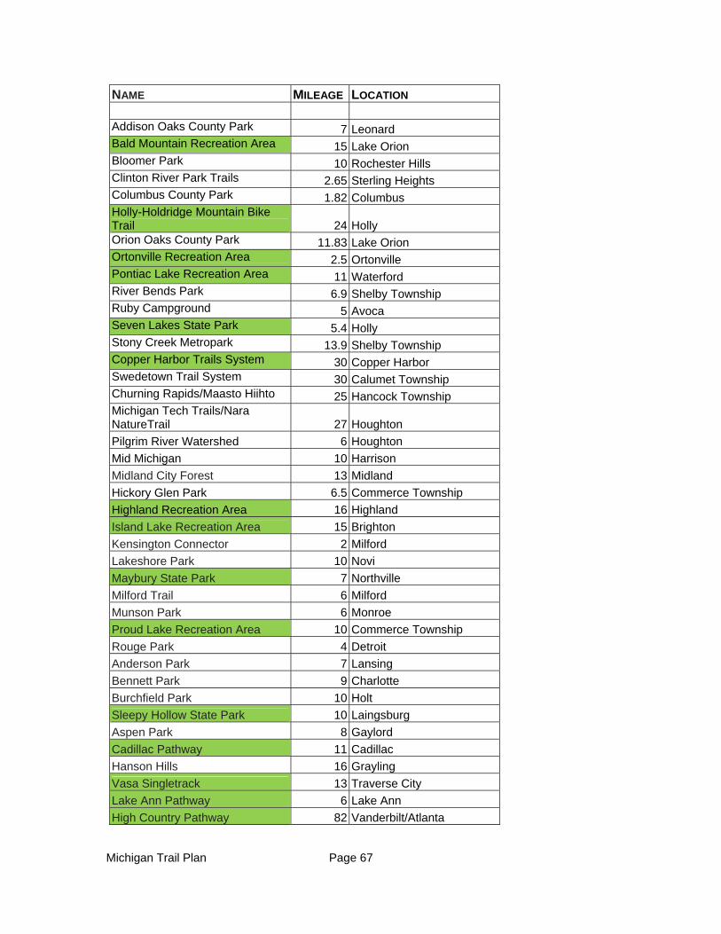
Michigan Trail Plan Page 67
NAME MILEAGE LOCATION
Addison Oaks County Park 7 Leonard Bald Mountain Recreation Area 15 Lake Orion Bloomer Park 10 Rochester Hills Clinton River Park Trails 2.65 Sterling Heights Columbus County Park 1.82 Columbus Holly-Holdridge Mountain Bike Trail 24 Holly Orion Oaks County Park 11.83 Lake Orion Ortonville Recreation Area 2.5 Ortonville Pontiac Lake Recreation Area 11 Waterford River Bends Park 6.9 Shelby Township Ruby Campground 5 Avoca Seven Lakes State Park 5.4 Holly Stony Creek Metropark 13.9 Shelby Township Copper Harbor Trails System 30 Copper Harbor Swedetown Trail System 30 Calumet Township Churning Rapids/Maasto Hiihto 25 Hancock Township Michigan Tech Trails/Nara NatureTrail 27 Houghton
Pilgrim River Watershed 6 Houghton
Mid Michigan 10 Harrison
Midland City Forest 13 Midland
Hickory Glen Park 6.5 Commerce Township
Highland Recreation Area 16 Highland
Island Lake Recreation Area 15 Brighton
Kensington Connector 2 Milford
Lakeshore Park 10 Novi
Maybury State Park 7 Northville
Milford Trail 6 Milford
Munson Park 6 Monroe
Proud Lake Recreation Area 10 Commerce Township
Rouge Park 4 Detroit
Anderson Park 7 Lansing
Bennett Park 9 Charlotte
Burchfield Park 10 Holt
Sleepy Hollow State Park 10 Laingsburg
Aspen Park 8 Gaylord
Cadillac Pathway 11 Cadillac
Hanson Hills 16 Grayling
Vasa Singletrack 13 Traverse City
Lake Ann Pathway 6 Lake Ann
High Country Pathway 82 Vanderbilt/Atlanta
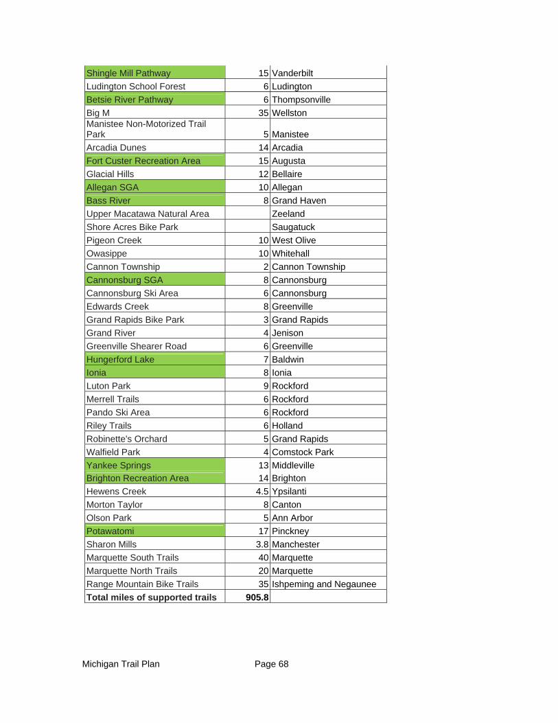
Michigan Trail Plan Page 68
Shingle Mill Pathway 15 Vanderbilt
Ludington School Forest 6 Ludington
Betsie River Pathway 6 Thompsonville
Big M 35 Wellston Manistee Non-Motorized Trail Park 5 Manistee
Arcadia Dunes 14 Arcadia
Fort Custer Recreation Area 15 Augusta
Glacial Hills 12 Bellaire
Allegan SGA 10 Allegan
Bass River 8 Grand Haven
Upper Macatawa Natural Area Zeeland
Shore Acres Bike Park Saugatuck
Pigeon Creek 10 West Olive
Owasippe 10 Whitehall
Cannon Township 2 Cannon Township
Cannonsburg SGA 8 Cannonsburg
Cannonsburg Ski Area 6 Cannonsburg
Edwards Creek 8 Greenville
Grand Rapids Bike Park 3 Grand Rapids
Grand River 4 Jenison
Greenville Shearer Road 6 Greenville
Hungerford Lake 7 Baldwin
Ionia 8 Ionia
Luton Park 9 Rockford
Merrell Trails 6 Rockford
Pando Ski Area 6 Rockford
Riley Trails 6 Holland
Robinette's Orchard 5 Grand Rapids
Walfield Park 4 Comstock Park
Yankee Springs 13 Middleville
Brighton Recreation Area 14 Brighton
Hewens Creek 4.5 Ypsilanti
Morton Taylor 8 Canton
Olson Park 5 Ann Arbor
Potawatomi 17 Pinckney
Sharon Mills 3.8 Manchester
Marquette South Trails 40 Marquette
Marquette North Trails 20 Marquette
Range Mountain Bike Trails 35 Ishpeming and Negaunee
Total miles of supported trails 905.8
Michigan Trail Plan Page 69
For over 20 years mountain biking advocacy organizations have been engaged in supporting the construction, maintenance, programming and promotion of trails in the state. In recent years leaders of many of the local organizations made a strategic decision to more strongly align themselves with the International Mountain Bicycling Association (IMBA). IMBA is a 501(c)3 non-profit educational association whose mission is to create, enhance, and preserve great mountain biking experiences.
There are many other organizations that have been effective advocates for mountain biking, and have built and continue to maintain trails across the state. In Upper Michigan specifically, mountain bike trails have been developed by various local trail organizations. The communities of Marquette, Ishpeming, Houghton, and Calumet have benefited greatly from the work of these local trail organizations. Together, all of these organizations have played a key role in the development of the sport in Michigan and will continue to be important partners. For example, the Copper Harbor Trails Club (CHTC) builds and maintains the trails in Copper Harbor that are recognized as an IMBA Silver Level Ride Center (one of only seven in the country) and also works with other trail groups in the Keweenaw as a member of the Keweenaw Trails Alliance. The Noquemenon Trail Network (NTN) in Marquette County is the driving force for mountain bike trail development in the central Upper Peninsula.
The Michigan mountain biking community has approximately 1,500 active members within the various IMBA chapters and hundreds more in organizations not currently associated with IMBA. The local groups work hard to be a substantial partner in trail development and maintenance projects. In many cases they are the reason that trails require little or no financial support from state DNR, local municipalities or counties. In 2012 alone, mountain biking volunteers donated over 13,600 hours building and maintaining trails throughout the state and this doesn’t include their time supporting events, programs, administration, etc. This equates to approximately $275,000 worth of volunteer labor with these benefits going to all users of the trails. Trails are built and maintained using nationally recognized IMBA/National Forest Service standards.
Recreational mountain biking provides significant economic impact especially in communities near trails. Mountain bikers eat at local establishments, purchase gas and other supplies as well as support local bike shops statewide. Mountain bike events such as races and tours create even more economic impact including enticing out-of-state riders to travel to Michigan for high quality events. Mountain bike races and festivals are happening nearly every week of the year throughout the state ranging from small chapter/club oriented week night time trials to large national level competitions that draw thousands of participants and spectators.
According to the Outdoor Industry Association’s (OIA) 2012 Annual Report, “Running, jogging and trail running are the most popular outdoor activities with almost 51 million participants and a participation rate of 18 percent.” The vast majority of trails are built and maintained by mountain bikers, especially on state land, is open to hikers and trail runners. The OIA states that 15% of Americans age six and older participate in

Michigan Trail Plan Page 70
cycling and mountain biking and biking is the most popular outdoor activity for youth ages (six to 17). Vision of what a quality mountain bike system would look like:
A successful mountain bike trail is one that provides a high quality experience for any level of rider. A variety of purpose-built trails for varying abilities, adequate mileage of trails, combined with support facilities including accessible trailheads, restrooms and signage are now preferred for destination mountain bike riding. Mountain bike trail systems can vary greatly from one region to the next because of vegetation, soils, terrain and historical development. With advances in mountain bike technology along with an increase in riders, trails are evolving. While traditional single track trails are desirable, so are purpose built “flow” trails that have been built with machines and extensive labor.
The vision for the state’s mountain bike trail system is a high quality, sustainable system of well-marked looped trails of varying lengths (five-30 miles) that are easily accessible to all of Michigan’s population.Premier trails and destinations with multiple trail options will be marketed through a campaign coordinated between State, local, and private (bike shops, user groups, etc.) efforts. Premier trails include trails with unique features or landscapes, long distance opportunities (30-100 miles) with hut-to-hut or camping options or varied levels of challenge.
Longer distance trails benefit from signage which provides distances to local amenities where available, using a system similar to the Tourist Oriented Destination Signs (TODS) program found on the interstate highways. Signage with unique location codes would also enhance emergency response capabilities for emergencies along the trails.
Races, organized rides and other events are encouraged and supported by the trail manager and local businesses. There is an ongoing effort to connect looped and linear mountain bike trails to other trails, as well as to nearby towns, parks, and other destinations where restrooms, parking, bike repair, food, and other amenities are available.
Michigan has a very organized and active system of non-profit mountain bike user groups. Utilizing this network of mountain bike trail users, the DNR should develop an informed group of mountain bike trail advocates who share a common interest with the DNR, other land managers and other trail users in assuring the availability of and access to high quality mountain bike trails and related facilities. Clear and replicable trail management agreements should be encouraged with these non-profit organizations.
Mountain bike trail use benefits from a thoroughly mapped trail system. Utilizing this inventory of trails, a statewide network of high quality mountain bike trails should be identified and promoted. Include in this promotion the related facilities and businesses in such a manner that Michigan becomes widely known as a state that both welcomes and promotes mountain bike recreation. The state of Michigan would benefit by tying in the adventure inherent in the sport of mountain biking with a focused Pure Michigan advertising campaign. The state has some of the best trails
Michigan Trail Plan Page 71
in the country and few people know this fact. Other states capitalize on the attraction to this sport and have made a name for themselves as mountain biking destinations. Michigan has the trails to be a national and international destination, the state needs to capitalize on this asset.
Opportunities – Gaps, Regional Needs
Opportunities:
Most looped trails were designed for hiking and cross country skiing, making them acceptable for mountain biking but not necessarily attractive to the “hard-core” mountain biking enthusiast. These trails, were not built to current development guidelines and as a result, do not hold up over the long term. Appropriately designed mountain bike trails are built to be compatible with the environment, are easier to maintain, and are more attractive to all levels of mountain bikers. Designated single track mountain bike trails could be developed within existing looped trail areas, sharing trailheads and facilities with other looped trails but separated from other trail users as needed. These trails could also be used by snow bikers and snowshoe trail users, providing an alternative to using groomed cross country ski trails in the winter.
Across the nation destination mountain bike trail systems are being constructed by specially-trained professional trail contractors utilizing local, state, and federal funding.
Gaps:
Gap: Dedicated financial support to professionally reconstruct or replace legacy trails is needed to support growing visitor use in all areas of the state and to complete visions and connections such as the Keweenaw Point Trail and the Pinckney-Waterloo Trail.
Gap: There should be a mountain bicycling representative on the Michigan Snowmobile and Trails Advisory Council. This would assist the DNR and other agencies in creating trails that also maximize their potential to attract and profit from mountain bicyclists.
Gap: There is still a need for land acquisition, specifically in Copper Harbor, to protect the heart of the trail system and allow for connections to adjacent land for future growth and development.
Gap: Partnerships are helping to bridge needs across the state. State Park staff are recognizing the economic impact of mountain biking and the investment and contributions of local organizations and are working with the clubs and chapters on opportunities as they become available. Examples of a successful partnership:
The Shingle Mill and High Country Pathways. These have been maintained utilizing volunteers from the Northern Michigan Mountain Bike Association (NMMBA). Volunteers from across the northern Lower Peninsula ensure the trails are maintained and boardwalks are repaired. The High Country Pathway has been established as an IMBA Epic Ride,
Michigan Trail Plan Page 72
which is an international recognition of the quality of this mountain bike experience.
In a town of 160 year round residents, the Copper Harbor Trails Club employs 1 full time and 3 part time professional trail builders and has a vision to expand further through fundraising and contract projects. Copper Harbor Trails – Silver Level IMBA Ride Center could be utilized as a statewide model to help guide other areas.
Opportunities for Related Business Development:
Businesses in communities that are in close proximity to a popular trail destination will attest that trails do have a substantial economic impact on their bottom line. At the trails themselves and in the surrounding community trails have the ability to serve both the mountain biking community and the surrounding area:
Tourism and Guiding –Based on an Outdoor Industry Association study, 80% of mountain bikers take at least one mountain biking trip/year (1 or more nights) with 4.6 nights average length of stay. 45% prefer to camp and 45% prefer bed and breakfasts or inns with 8% preferring hotels.
Increased rental concessions and retail on both state property and in surrounding community – increasing access to bike rental and repair concessions can support numerous park attendees from campers and day-use visitors.
Local restaurant and business impact - the proximity of restaurants and brew pubs often plays a role in the level of use of mountain bike trails. Advertising along the trails and at trailheads for these and other establishments can provide important information for trail users as well as an income stream to support the trails.
Promotion and Media – the Copper Harbor Trails system, an IMBA Silver Ride Center, has been featured in numerous national magazine publications, online news outlets, professional videos, industry catalogs, and more. It has also been ranked one of the top 10 riding destinations in North America but has yet to be included in a Pure Michigan campaign.
Opportunities for Private Sector Involvement and Partnership:
Private sector partnerships with the DNR to enhance the mountain bike trail system are many. Partnership opportunities include trail event promotions, marketing of the trails, implementation of a “trail town” program, fundraising, and trail maintenance assistance.
Races and events can bring significant economic benefits to the host communities. For instance, the Bell’s Beer Iceman Cometh Mountain Bike Race now brings 5,000 competitors and over 10,000 supporting friends and family. In 2009 the race was capped at 2,500 competitors. The race organizers and local stakeholders estimated the economic impact to the Traverse City area at $1.5 million. The Ore to Shore Race in the Marquette area brings in over 2,000 racers on an annual basis.
Michigan Trail Plan Page 73
Many municipal trail development projects are employing fund raising strategies to support the development of new trail assets. For example, the Merrell Trail outside of Grand Rapids was funded in part by the Merrell Corporation and in return they granted naming rights.
IMBA Destinations have been proven to be a recipe for creating a high quality trail network that not only evaluates the trail system but the surrounding resources and amenities.
Threats and Challenges
Trails shared with equestrians are often the site of conflicts. Shared use is achievable with well-thought-out design and soil evaluation; however, the majority of the shared use trails do not meet either criteria. There is little data gathered at the state level as to the specific trail use characteristics and, therefore, the economic development associated with this trail use is underestimated and not well understood. Lack of economic impact data for trails is a serious threat as the current and future potential will go unrecognized.
Lack of funding support needs to be addressed. Mountain biking in Michigan is not only very popular, but is also big business. Continuing to rely on local non-profit organizations to support the construction and maintenance of trails in the state is not sustainable. DNR facilities are benefiting directly through campground use and permit fees and should be contributing to the trails built and maintained by local mountain bike organizations that are used by numerous other user groups.
Priorities/Goals
1. Integrate the hundreds of miles of mountain biking trails into statewide trail promotion and branding efforts including Pure Michigan and Trail Towns.
Recommendations:
Collaborate with the Up North Trails project, IMBA and MTBprogram.com to develop a comprehensive mountain biking trail inventory and mapping initiative and include in statewide marketing and branding efforts
Develop marketing tools to promote both statewide and regional trail destinations highlighting mountain bike trails and IMBA Destinations Develop, enhance, and document the resources and relationships between mountain bike organizations and local, regional and state DNR staff.
Recommendations:
Create a streamlined process for DNR review and approval of trail events/permits, maintenance partnerships, and trail building efforts.
Create a process and policy related document clearly detailing the creation, adjustment, and maintenance of mountain bike trails on state land.
Michigan Trail Plan Page 74
Provide a convenient and economical opportunity for leaders of the mountain bike community to interact with key DNR staff and land managers.
Create a statewide trail manual, similar to Minnesota’s, that establishes clear criteria, a definitive process, and evaluation of trails for all users for Michigan.
Provide for a more equitable voice of all users in the MSTAC committee ensuring all groups are represented.
Recommendations:
Nominate a representative of the mountain biking community to both the MSTAC committee and the non-motorized sub-committee. Include Upper Peninsula representation as feasible.
Develop reliable data on the economic impact of mountain biking trails, events, and tourism to or in the state of Michigan.
Recommendations:
Collaborate with universities, communities and other stakeholders to develop a statewide economic impact study on mountain biking trails, events, and tourism
Develop a template for local and regional events to better measure impact and tourism draw
Increase access to natural surface trail systems, including multi-use recreation trails
Recommendations:
Identify, master plan and develop off-road bike trail infrastructure connections to the extensive off-road multi-use recreation trail network to create better access for communities, neighborhoods and family
Develop additional outlets to encourage, support, and incentivize local trail groups to build, maintain, and promote trails throughout the state.
Recommendations:
Define and implement a process to recognize, incentivize, and support local trail organizations who volunteer to build, maintain, program, and promote natural surface sustainable single track trails:
o DNR Volunteer Awards, Hall of Fame, etcetera
o Create a system of incentives to motivate trail users to become trail stewards
Create clear and accessible criteria for federal, state, and local trail funding and decision making
Michigan Trail Plan Page 75
EQUESTRIAN TRAILS
Background
The process to develop comprehensive equestrian trail recommendations started in March of 2010, when the Parks and Recreation Division (PRD) of the DNR initiated an internal assessment of equestrian (EQ) opportunities and needs for use of PRD lands in state recreation areas in southern Michigan. This assessment led ultimately to a recommendation to develop a statewide EQ plan for the DNR to address all DNR lands and to provide trail experiences for more than 50,000 equestrians in the state (ETS 2011 Recommendations Report, Appendix 5). To help move that process forward, an application for planning assistance was submitted to the National Park Service - Rivers, Trails & Conservation Assistance (RTCA) Program seeking planning assistance, and that was approved.
On April 1, 2010, the Michigan Snowmobile and Trails Advisory Council (MSTAC) and the Equine Trailways Subcommittee (ETS) were established with the enactment of Public Acts 45 and 46 of 2010. These acts defined EQ use on state lands and charged the ETS, MSTAC, and the DNR with the responsibility of developing recommendations for a trail network system for the state and thus dovetailed with the March 2010 process. A specific timeline was established that required the ETS to make their recommendation to the MSTAC by June of 2011. MSTAC accepted the report in July of 2011and the final plan was approved in February of 2012. This Michigan Comprehensive Trail Plan uses the EQ recommendations from the ETS 2011 Recommendations Report and the EQ Workgroup report.
Links to the ETS report can be found in Appendix 5:
In the 2010 ETS Recommendation Report, the ETS provided 46 recommendations summarized under the four main goals that follow:
Identify and promote a statewide network of high quality pack and saddle trails and related facilities/businesses in such a manner that Michigan becomes widely known as a state that both welcomes and promotes saddle and pack equine recreation.
Establish effective collaborations and partnerships to identify, develop, and maintain a generous set of safe, financially sustainable and ecologically sound equine trail recreational opportunities on public and leased private lands spatially distributed across the state.
Develop an informed group of equine trail users who share a common interest with the DNR, other land managers and other trail users in assuring the availability of and access to high quality pack and saddle trails and related facilities.
Develop partnerships and collaborations with the DNR, other land managers, and other trail users for support, expansion, and maintenance of Michigan trails and related facilities as well as minimization of user conflicts and illegal use.
Michigan Trail Plan Page 76
This section of the Michigan Comprehensive Trails Plan builds on and refines the recommendations from the ETS 2011 Recommendations Report; however, it abbreviates the EQ workgroup report. The unabbreviated EQ workgroup report is included in Appendix 6. It contains additional detail regarding the existing trail system and how the type of state land influences equine riding opportunities; a more detailed vision statement for 2016; a report on rider characteristics, concerns, and perceived needs; and an expanded discussion of barriers and threats to equine activities on state lands.
Description of the Existing Trail System
The DNR has initiated a comprehensive inventory of EQ trails and facilities on state lands; it is anticipated that this inventory will be completed soon and regularly updated. To understand where EQ use is currently allowed and issues for expansion, it is important to recognize that different types of state lands have different rules and regulations with respect to EQ use.
The manner in which designated trails were established on public land varies significantly based on the funding source used to acquire the parcel and its location within designated boundaries. Section 72115 of PA 45 of 2010 defines where EQ use is allowed:
State Parks and Recreation Areas
EQ use in state parks and state recreation areas is allowed only on “designated EQ” trails. The designation of uses is made by DNR program managers in consideration of a wide variety of environmental factors and legal requirements. The designation of an existing trail and/or the development of new infrastructure are often guided by DNR Management Zone Plans that have been developed for state parks and recreation areas. The establishment of these plans involves public participation and a careful review of each park’s unique conditions, including legal mandates, funding sources used for land acquisition, and the natural features that could impact use, such as: soil, terrain and hydrology. This comprehensive analysis provides prescriptive guidance as to what recreation uses will be allowed in certain areas and is the guiding document when considering requests for additional facilities. Within state parks and recreation areas with designated EQ trails and campgrounds, the DNR relies on partnerships with user groups to develop new EQ trails and to provide long-term maintenance assistance. It is DNR’s objective that all EQ trails have a user group before being approved for development.
State parks and recreation areas with EQ facilities are all located in southern Michigan (see Exhibit 1). They are:
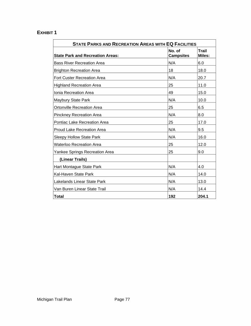
Michigan Trail Plan Page 77
EXHIBIT 1
STATE PARKS AND RECREATION AREAS WITH EQ FACILITIES
State Park and Recreation Areas: No. of Campsites
Trail Miles:
Bass River Recreation Area N/A 6.0
Brighton Recreation Area 18 18.0
Fort Custer Recreation Area N/A 20.7
Highland Recreation Area 25 11.0
Ionia Recreation Area 49 15.0
Maybury State Park N/A 10.0
Ortonville Recreation Area 25 6.5
Pinckney Recreation Area N/A 8.0
Pontiac Lake Recreation Area 25 17.0
Proud Lake Recreation Area N/A 9.5
Sleepy Hollow State Park N/A 16.0
Waterloo Recreation Area 25 12.0
Yankee Springs Recreation Area 25 9.0
(Linear Trails)
Hart Montague State Park N/A 4.0
Kal-Haven State Park N/A 14.0
Lakelands Linear State Park N/A 13.0
Van Buren Linear State Trail N/A 14.4
Total 192 204.1
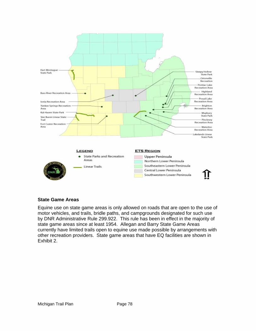
Michigan Trail Plan Page 78
State Game Areas
Equine use on state game areas is only allowed on roads that are open to the use of motor vehicles, and trails, bridle paths, and campgrounds designated for such use by DNR Administrative Rule 299.922. This rule has been in effect in the majority of state game areas since at least 1954. Allegan and Barry State Game Areas currently have limited trails open to equine use made possible by arrangements with other recreation providers. State game areas that have EQ facilities are shown in Exhibit 2.
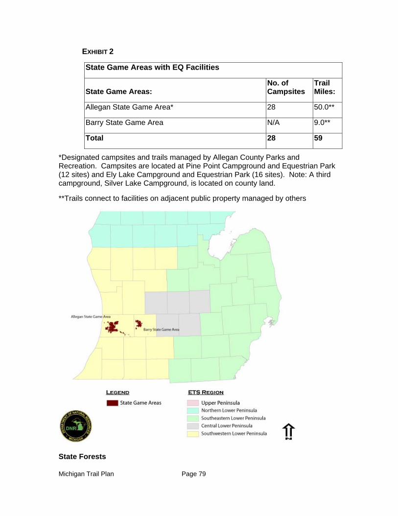
Michigan Trail Plan Page 79
EXHIBIT 2
State Game Areas with EQ Facilities
State Game Areas: No. of Campsites
Trail Miles:
Allegan State Game Area* 28 50.0**
Barry State Game Area N/A 9.0**
Total 28 59
*Designated campsites and trails managed by Allegan County Parks and Recreation. Campsites are located at Pine Point Campground and Equestrian Park (12 sites) and Ely Lake Campground and Equestrian Park (16 sites). Note: A third campground, Silver Lake Campground, is located on county land.
**Trails connect to facilities on adjacent public property managed by others
State Forests
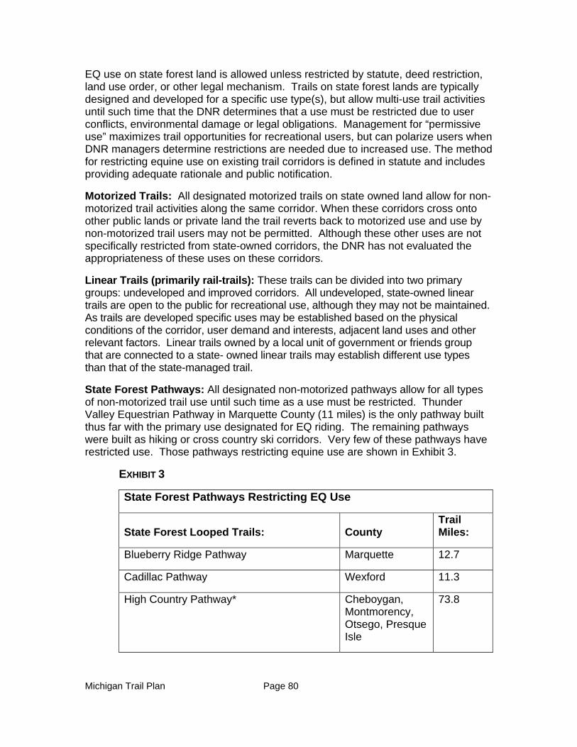
Michigan Trail Plan Page 80
EQ use on state forest land is allowed unless restricted by statute, deed restriction, land use order, or other legal mechanism. Trails on state forest lands are typically designed and developed for a specific use type(s), but allow multi-use trail activities until such time that the DNR determines that a use must be restricted due to user conflicts, environmental damage or legal obligations. Management for “permissive use” maximizes trail opportunities for recreational users, but can polarize users when DNR managers determine restrictions are needed due to increased use. The method for restricting equine use on existing trail corridors is defined in statute and includes providing adequate rationale and public notification.
Motorized Trails: All designated motorized trails on state owned land allow for non-motorized trail activities along the same corridor. When these corridors cross onto other public lands or private land the trail reverts back to motorized use and use by non-motorized trail users may not be permitted. Although these other uses are not specifically restricted from state-owned corridors, the DNR has not evaluated the appropriateness of these uses on these corridors.
Linear Trails (primarily rail-trails): These trails can be divided into two primary groups: undeveloped and improved corridors. All undeveloped, state-owned linear trails are open to the public for recreational use, although they may not be maintained. As trails are developed specific uses may be established based on the physical conditions of the corridor, user demand and interests, adjacent land uses and other relevant factors. Linear trails owned by a local unit of government or friends group that are connected to a state- owned linear trails may establish different use types than that of the state-managed trail.
State Forest Pathways: All designated non-motorized pathways allow for all types of non-motorized trail use until such time as a use must be restricted. Thunder Valley Equestrian Pathway in Marquette County (11 miles) is the only pathway built thus far with the primary use designated for EQ riding. The remaining pathways were built as hiking or cross country ski corridors. Very few of these pathways have restricted use. Those pathways restricting equine use are shown in Exhibit 3.
EXHIBIT 3
State Forest Pathways Restricting EQ Use
State Forest Looped Trails: County Trail Miles:
Blueberry Ridge Pathway Marquette 12.7
Cadillac Pathway Wexford 11.3
High Country Pathway* Cheboygan, Montmorency, Otsego, Presque Isle
73.8
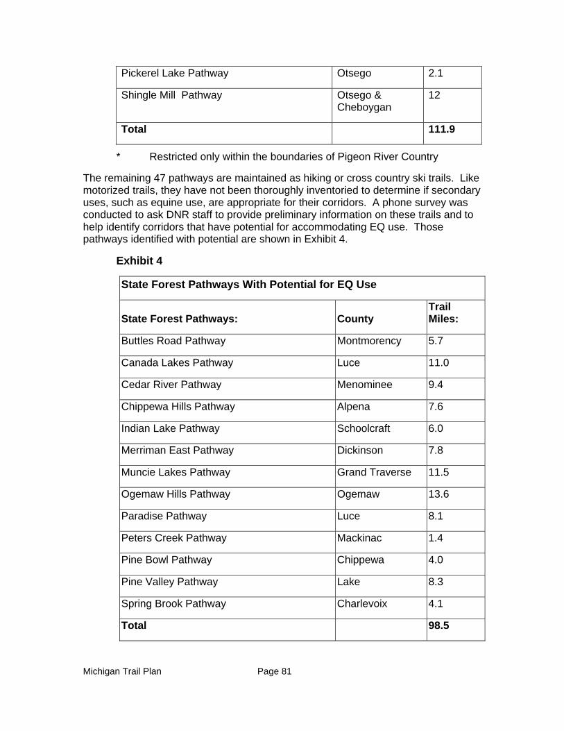
Michigan Trail Plan Page 81
Pickerel Lake Pathway Otsego 2.1
Shingle Mill Pathway Otsego & Cheboygan
12
Total 111.9
* Restricted only within the boundaries of Pigeon River Country
The remaining 47 pathways are maintained as hiking or cross country ski trails. Like motorized trails, they have not been thoroughly inventoried to determine if secondary uses, such as equine use, are appropriate for their corridors. A phone survey was conducted to ask DNR staff to provide preliminary information on these trails and to help identify corridors that have potential for accommodating EQ use. Those pathways identified with potential are shown in Exhibit 4.
Exhibit 4
State Forest Pathways With Potential for EQ Use
State Forest Pathways: County Trail Miles:
Buttles Road Pathway Montmorency 5.7
Canada Lakes Pathway Luce 11.0
Cedar River Pathway Menominee 9.4
Chippewa Hills Pathway Alpena 7.6
Indian Lake Pathway Schoolcraft 6.0
Merriman East Pathway Dickinson 7.8
Muncie Lakes Pathway Grand Traverse 11.5
Ogemaw Hills Pathway Ogemaw 13.6
Paradise Pathway Luce 8.1
Peters Creek Pathway Mackinac 1.4
Pine Bowl Pathway Chippewa 4.0
Pine Valley Pathway Lake 8.3
Spring Brook Pathway Charlevoix 4.1
Total 98.5
Michigan Trail Plan Page 82
The remaining pathways have conditions which are not conducive for EQ riding as identified by DNR staff.
Trails Owned/Maintained by Other Organizations
Other trails such as the North Country National Scenic Trail (developed by the Federal Government with assistance of volunteers), Midland to Mackinaw Trail (developed by the Boy Scouts) and the Michigan Shore-to-Shore Riding/Hiking Trail were initiated and developed by others for a specific trail activity. Only the Michigan Shore-to-Shore Trail is open in its entirety to EQ use. Like the motorized trails, these trails cross a patchwork of land ownership and jurisdictions. The DNR and other land owners have given these trail managers approval to develop and maintain the trail on their lands.
Other Public Agencies
Federal agencies and local units of government are also important providers of EQ trails and campgrounds. The U.S. Forest Service (USFS) is the primary federal landowner in Michigan. On USFS lands, horse and pack animals are allowed on lands, trails and campgrounds unless designated as closed to equines. Lands administered by the National Park Service are closed to use of horses and pack animals outside of trails, routes or areas specifically designated for their use (Code of Federal Regulations), such as the Alligator Hill Trail within Sleeping Bear Dunes National Lakeshore.
In southern Michigan, where state and federal forests do not exist, county and regional park systems provide additional EQ trail and camping opportunities. Key examples include Oakland County Parks, the Huron Clinton Metropark Authority (HCMA), and Allegan County Parks.
Vision Statement (condensed- See Appendix for full vision)
Equestrians enjoy a generous, diverse, enjoyable, safe, financially sustainable and ecologically sound network of high quality public and private equine trails and camping facilities within the State of Michigan. Michigan is known as a state that welcomes and promotes equine trail recreation. Equine trails, trailheads, and camping facilities are dispersed throughout the state in such a manner that from any point within the state, there will be riding opportunities within a two- hour drive, overnight equestrian accommodations within a four- hour drive, and Signature Equestrian Centers within an eight- hour drive.
The vision for a quality equestrian system is based on the data gathered from focus group meetings, surveys, the ETS 2011 Recommendations Report and the USDA Forest Service (Hancock, et.al, 2007). More detail regarding ideal design components that define “high quality” trails, trailheads, campgrounds and a “Signature Equestrian Center” are included in the EQ appendix.
Equine Trail Characteristics, Concerns, and Perceived Needs
Statewide Opportunities
The statewide opportunities listed below are based on focus group meetings and an Equestrian Trail User Survey, all of which were conducted in August and September
Michigan Trail Plan Page 83
of 2012. A focus group meeting was held within each of the ETS Regions and a total of 55 individuals representing various equine associations participated. The Equestrian Trail User Survey was distributed statewide electronically through user groups, and garnered 574 responses from individual horse riders.
Other surveys were referenced, including the ETS Trail Survey found in the ETS 2011 Recommendations Report, the DNR’s Trail Survey of all trail users conducted in August 2012, and other states’ research related to demand for EQ trails and campgrounds.
The following opportunities are based on data analysis of the surveys and focus group meetings cited above.
Priorities
When asked to make a choice, the majority of riders participating in either the focus groups or answering the Equestrian Trail User Survey would prefer to see an increase in the number of EQ trails and campground facilities over improving existing EQ trails and campgrounds. However, many also had concrete ideas for improvements that would expand existing trail lengths, and for achievable maintenance initiatives that would improve the existing system.
This and previous surveys consistently found that respondents also desire more riding opportunities near their homes. This finding was supported in focus group meetings, but those attending in low population areas, such as the UP, were concerned that their input would be silenced by the number of riders living near larger urban centers. All regions should be reviewed for expanding single-day riding opportunities consistent with the Vision objectives.
Trails - While most participants of the focus group meetings and surveys currently ride a variety of surfaces and locations, most prefer to ride on loop trail systems that offer variable scenery and terrain, away from motorized traffic and other user groups. Shade was also cited as extremely important in the DNR’s Trail Survey. For better riding experiences, three to five loops at a given site were recommended.
Trailheads - The four most important trailhead amenities identified in the Equestrian Trail User Survey include: 1) water for equines, 2) adequate car and trailer parking, 3) generous vehicle/trailer turn-around space and 4) shade. The next item of importance 5) hitching posts and/or picket poles for equines received significantly less interest than the top rated items.
Campgrounds - According to the ETS survey, 85 percent of EQs camp overnight. As identified in the Equestrian Trail User Survey, the four most important campground amenities are 1) pull-through sites, 2) campsites designed for larger trailers, 3) electricity at campsites and 4) shade trees. Providing showers (Item #5) and modern toilet building (Item #6) scored close to providing shade. Converting hand pumps to a pressurized water system was ranked eighth out of the 22 available options. This lower ranking was supported later when 74 percent of the respondents indicated that hand pumps were adequate to meet their watering needs within a
Michigan Trail Plan Page 84
campground. Many respondents indicated that they camp with their own water supply that will last them a couple of days.
Ride Duration and Length - The majority of participants of the focus group meetings and the online survey indicated that day riding was the most common EQ experience they participated in, traveling up to two hours to do so. Multi-day riding from one camping location was second with the majority of participants traveling up to four hours to get to their EQ facility location. Overall, the surveyed EQs will typically travel up to four hours for a quality riding experience.
For day rides, the majority of participants (44.9 percent) ride between five and 10 miles, although another 40 percent ride for 10 to 20 miles. For multi-day ride experiences, the majority of riders (51.5 percent) ride between 10 and 20 miles per day. When developing new trail experiences, this result indicates that daily trail lengths five to 20 miles either in a looped system or between campgrounds/trailheads are ideal.
Communication - Analysis of survey data and focus group comments indicate a need for better communication between EQ organizations and the DNR. The top three opportunities for improvements in communication include:
1. A statewide map, guidebook and website listing (with maps) of all EQ trail facilities (campgrounds, trails, trailheads).
2. Better signage at all EQ facilities clearly identifying directions (including confidence markers), rules, regulations, emergency contacts, legal restrictions and maps.
3. More DNR communication and education with EQ partners. From past experience, it is assumed this communication would be about issues such as existing facilities and trails, expansion plans, maintenance issues, trail etiquette, trail conflicts, land management plans including timber harvest plans, and limitations because of land characteristics and/or funding sources.
Maintenance Fees - According to the DNR’s Trail Survey, 80 percent of EQs would support an annual fee for trail maintenance. The 2011 ETS Survey (see Appendix 6) results also support this initiative; however respondents in the southeast Lower Peninsula showed the greatest opposition to fees. These results suggest an opportunity to investigate and implement these types of fundraising mechanisms in support of EQ trails.
Southeast Lower Peninsula Opportunities - While EQs in the southeast Lower Peninsula take advantage of riding opportunities in other parts of the state, the focus group participants (eight total) preferred to stay closer to home when riding. When compared to the rest of the state, riders from this area prefer day rides that are on looped trails. This result could be a reflection of the greater number of looped trail riding and camping opportunities offered to the riders in this region. It should also be noted that only a few participants from other focus group indicated a desire to travel to southeast Lower Peninsula for their riding opportunities.
Michigan Trail Plan Page 85
Survey data defining desired trail lengths and demographic information for this area indicate a need to increase EQ trail connection opportunities in this region. Specifically, connector trails are desired between state recreation areas. The top three locations for riding in this region are Proud Lake State Recreation Area, Highland State Recreation Area and Waterloo/Pinckney State Recreation Area.
Central Lower Peninsula Opportunities - Central Lower Peninsula focus group EQs (six total) mainly ride at Ionia State Recreation Area and Sleepy Hollow State Park. When compared with the rest of the state, riders from this area are more likely to travel for multi-day rides. Many riders, from this region, have an interest in traveling to the Northern Lower Peninsula for a “quality” trail riding and camping experience. This focus group population desire more trails within the region, improved trail signage, more trails in Sleepy Hollow State Park including connection of Sleepy Hollow State Park trails to the Clinton-Ionia-Shiawassee Trail, and on the Clinton-Ionia-Shiawassee Trail linkages where EQ use is currently not allowed.
Southwest Lower Peninsula Opportunities - While focus group EQs (seven total) in the Southwest Lower Peninsula currently ride primarily at Yankee Springs State Recreation Area, Hungerford Lake Federal Recreation Area, and Silver Creek (Allegan State Game Area), many prefer to travel to the Northern Lower Peninsula for multi-day riding experiences. These riders shared the desire for more trails and campgrounds in their region. Users in this region specifically requested campgrounds with larger sites and longer trail lengths. Focus group participants mentioned the desire for a more modern, better designed campground, as well as the addition of a children’s trail that circles the campground, and connector trails between existing loop trails.
Northern Lower Peninsula Opportunities - Current use in this region by focus group participants (19 total) primarily occurs at Pigeon River Country State Forest and the Michigan Shore to Shore Hiking and Riding Trail. EQs from this region shared many of the same desires in the statewide opportunities listed above. The primary desire of participants in the Northern Lower Peninsula focus group was centered around the expansion of EQ opportunities (state and federal) in the region and, specifically, to open more riding and camping opportunities within or near the Pigeon River Country State Forest and west of I-75. More well-marked looped trails associated with existing and new campgrounds were also requested. Other desires included a modern campground facility to attract riders from other regions (Wisconsin and the Lower Peninsula) and more trails in state forests. In the survey, multi-day riding trended higher than single-day riding. Northern Lower Peninsula EQs also desired better communication with the DNR in developing new facilities.
Upper Peninsula Opportunities - The primary concern of the focus group EQs in the Upper Peninsula (15 total) was to increase the riding opportunities in their region. Many of the focus group participants indicated that the majority of their riding and cart/carriage driving occurs within the region and they expressed a strong desire for more state-owned EQ trail and camping opportunities. Also worth noting, when compared to the rest of the state, riders in this area preferred to ride on forest roads. Various sites for repurposing closed or under-developed campgrounds and trails were identified. Among these sites, the federal Pine Marten Trail was featured as
Michigan Trail Plan Page 86
having potential for expansion. Desired specific trail improvements included longer trails as well as wider trails to accommodate side-by-side riding and cart/carriage driving. Riders in this region also supported obtaining riding information from the internet as opposed to other forms of communication.
Opportunities for Business Related Development
Business related development can complement and enhance the trail user’s quality of experience. Examples include:
Tack shops accessible to EQ trails and campgrounds
Large animal veterinary services
Horse boarding (e.g. B&B for horses) and grooming
Stables with horses to rent and related services
Rider boarding (e.g. B&B, motel/hotel, campgrounds for people)
Restaurants, ice cream shops, fuel, grocery, and general merchandise (This is also supported by data in the DNR’s Trail Survey)
Outfitters or guides to support large group rides, etc. Entertainment and recreation opportunities in which EQ’s may participate
when not riding (e.g. movies, golf, fishing, swimming, etc.)
Many such examples already exist in Michigan and current business owners and entrepreneurs need to be made aware of the EQ market.
Opportunities for Private Sector Involvement
The opportunities for private sector involvement in support of EQ trail and camping use in Michigan are many. Examples include:
Festivals and events that promote EQ trail riding
Support for EQ groups and associations
Marketing and branding
Transient boarding facilities near trails
Fundraising
Endowment programs (identified in 2011 ETS report)
Partnerships with land trusts (e.g. Equestrian Land Conservation Resource and Trust)
Snowmobile trail private easement agreements (potential for EQ use)
Support and promotion of ‘Trail Towns’
Barriers (Threats)
Barriers to EQ activities in the state of Michigan were identified from the online survey and focus group meetings. These barriers act as road blocks for proposed EQ improvements in Michigan:
Michigan Trail Plan Page 87
Land Restrictions
There are many sources of funds that are used to purchase state lands for public use, all of which come with criteria on how the lands can be used. Three primary sources of funding that include restrictions with respect to EQ related and other forms of recreation on the acquired lands are (1) Pittman Robertson Wildlife Restoration Funds (PR), (2) Dingell Johnson Sport Fish Restoration Fund (DJ) and (3) License Fee Acquired Lands (LF).
PR/DJ Grant Acquired and Managed Lands: DNR lands which are PR/DJ acquired and/or managed are distributed in a checker board pattern across the state. Many of these areas are desirable to a variety of recreation users. Horseback riding is not prohibited on PR/DJ land. However, when it does occur, the intensity and frequency cannot interfere with the primary purpose of hunting and fishing. For example, PR/DJ funds cannot be used for enforcement of use restrictions or other non-PR/DJ purposes on PR/DJ lands. Should the US Fish and Wildlife Service determine that the state is not adequately managing the frequency and intensity of EQ use on these lands; and if a satisfactory resolution is not achieved, future PR/DJ funding is jeopardized. Since these funds have been significant—$23.5 million in 2012, careful management of EQ and other recreational activities (and other non-hunting and non-fishing activities) are necessary to ensure continued receipt of federal support.
License Fee Acquired and Managed Lands: Some DNR lands were acquired and/or are managed through hunting and fishing license fees. A provision of the PR (1937) and DJ (1950) Acts is that states must assent to only use state license fees for fish and wildlife services. Michigan passed the required Assent Law in 1939 and this provision is found in Section 324.40501 of the Natural Resources and Environmental Protection Act 451 where it states “…funds accruing to this state from license fees paid for by hunters shall not be used for any purpose other than game and fish activities under the administration of the DNR.”. The DNR complies with the law by only allowing for trails that support fish and wildlife purposes.
Collaboration
EQ organizations identified that their working relationship with the DNR varies between management areas. Consistent policies and procedures are needed to help ease these working relationships. Many users report that when they have expressed an interest in developing more trails, they have been frustrated with the lack of response from the DNR.
User Fees and Approvals
Confusing fee rates and the method and time for achieving approvals for use of EQ trail camps were identified as problems that needed resolution. Respondents expressed frustration over the dissimilarity of state camping fees compared to the amenities they offer. The lack of clear registration directions at unstaffed campgrounds was also cited as a problem.
Michigan Trail Plan Page 88
Travel Information
A lack of information on trail locations (maps) and trail conditions are barriers to attracting trail riders to Michigan. Additionally, 40% of EQs polled in the DNR’s 2012 Trail Survey indicate that the state has poor promotion of available EQ experiences.
Coordination
A lack of coordination and cooperation between EQ riding associations and groups was identified as a barrier to garnering approval, funding, and implementation of more EQ trails and campgrounds in Michigan. (Note: The list of EQ associations and groups found in the Appendix 6 totals nearly 88 individual groups statewide)
Education/Communication
Focus group comments and survey data show that the lack of information on how to use EQ trails causes barriers to a quality riding experience. Cited were the lack of trail signage, maps, information regarding rules and regulations, fee collecting procedures, and proper trail etiquette including “leave no trace” practices. Trail users cite that poor trail etiquette results in user conflicts.
Perceived Threats
Gas Prices/Distance From Home: Threats identified for the EQ community include high gas prices, which threaten to prevent EQs from traveling greater distances to their favorite destinations.
Out-of-State Facilities: Another potential threat to the EQ economy in Michigan is riders traveling out-of-state for their EQ experiences. Many EQs in the Upper Peninsula identified going to Wisconsin for their quality riding experience while others in the Southwestern Lower Peninsula cited trips to Indiana, Wisconsin, Kentucky, or Tennessee for their quality riding experience.
Use Conflicts: EQs identified that opportunities have diminished for them statewide due to real and perceived conflicts with other users. Regionally, user conflicts were higher in the Upper Peninsula and the northern Lower Peninsula with ORV users when compared to statewide average. Conflicts with hunters in southeast Lower Peninsula were higher than the statewide average.
Some recreation area users in the southern Lower Peninsula also had conflicts with mountain bikers, though the survey indicated state-wide that EQs had few interactions with other user groups while trail riding. Focus group meeting feedback perceived that other user groups did not want equines using the trails, and that trail closures could result. These perceived concerns include the inability to hear EQ users when they approach, the unpredictability of equines, manure left behind, and erosion of trail surfacing from equine use.
EQs expressed that other users do not know how to behave around equines and that there are safety concerns with mixing non-EQs with EQs in the same campground.
Michigan Trail Plan Page 89
Equity of Use: Minimal campground facilities have been created to serve EQ users. While EQs can only camp in these given facilities, other users are not necessarily excluded from equine campgrounds. In addition, the lack of EQ trails forces EQs to ride on trails not designed or built for them. The EQ user is asking for parity of facilities in line with other user types.
Maintenance and Construction: Although many EQ facilities are constructed and maintained by EQ associations and groups, larger projects may be difficult for these groups to accomplish. Examples of these activities may include access road improvements, severe erosion control and major tree clearing. While groups are willing to perform some of these tasks, these activities require special equipment, certifications, and/or licenses.
Overall Goals (Next 5 years)
Complete comprehensive EQ trails and facilities inventory
Improve and expand DNR EQ trails and facilities
Promote EQ trails and facilities to users and businesses
Collaborate with partners and governmental agencies to improve communications, expand riding opportunities and maintain trails and facilities
Identify and pursue stable funding to develop and maintain equine facilities
Develop a conflict resolution process
Recommendations
In partnership with the ETS and equine riding community, the following goals and recommendations were developed. The first three recommendations under each goal are the highest priority.
Goal #1 - Complete comprehensive EQ Trails and Facilities Inventory and Analysis
1. As part of the internet portal development, provide an online trails database that includes comprehensive geospatial data, descriptions, and pictures of public EQ trails, trailheads and campgrounds including those “permissive use” trails that are identified as suitable for EQ use. [Primary lead: DNR]
2. Once the inventory is adequate, provide a gap analysis of where infrastructure needs must be pursued to achieve the Vision and goals (e.g. abandoned county roads, utility corridors or user-created trails). [Primary lead: DNR]
3. Prioritize potential projects by geographic area in consideration of state lands and existing state facilities, and where trails and facilities can be enhanced and/or expanded for equine use. [Primary lead: DNR]
4. Develop guidelines and assess the suitability of ORV trails, snowmobile trails (undeveloped) rail-trails, and existing looped trails for EQ use. [Primary lead: DNR]
5. Inventory and publish EQ trails and facilities on other public lands such as county parks, municipalities and federal lands. [Primary lead: DNR]
Michigan Trail Plan Page 90
Goal #2 - Improve and Expand DNR EQ Trails and Facilities
1. Open opportunities in our state forest, parks and game areas to allow horseback riding when there is no conflict with pre-existing management plans, no issues surrounding legal use of lands and an assessment has been conducted on potential user conflicts. In those state lands where equine trail use has been curtailed due to management constraints (e.g. land funding restrictions) identify similar equine trail opportunities in close proximity to the closed trails, campgrounds, or trailheads. [Primary lead: DNR].
2. Expand riding trails at non-linear state parks and recreation areas with EQ facilities so riders have access to a minimum of 10 miles of trail. Look for opportunities to configure trails so multiple loops are provided including connections to other trails nearby (including neighboring states). [Primary lead: DNR]
3. Investigate opportunities to repurpose existing or reopen closed U.P. state forest campgrounds for EQ use, with the objective of designating 2 or more EQ campgrounds with access to 20 miles of loop trails and/or connectivity to existing equine trails in the Upper Peninsula. [Primary lead: DNR]
4. Investigate and provide designated trail riding opportunities in several dispersed locations in the Upper Peninsula that will provide a minimum of 10 miles of well-marked trails and basic trailhead amenities for day rides. [Primary lead: EQs]
5. Develop and implement the process to identify and connect existing EQ trails with particular attention to Southeast Michigan state parks and recreation areas. [Primary lead: EQs]
6. Using existing or new state forest EQ campgrounds north of Clare and south of the Mackinaw Bridge, identify opportunities for loop riding trail development that would provide a minimum of 20 total miles of riding opportunities per campground. [Primary lead: DNR]
7. Identify opportunities for designation of EQ trails in State Game Areas which won’t conflict with management plans or land acquisition or management funding sources. [Primary lead: DNR]
8. Conduct a demand analysis to determine the need for a Signature Equestrian Park(s). [Primary lead: ETS/MSTAC]
9. Based on positive demand analysis results, identify potential locations for Signature Equestrian Parks and provide pros and cons for each. [Primary lead: DNR]
10. Develop uniform sign guidance covering design, content and location information for use on EQ trails, trailheads, and campgrounds. Partner with Friends Groups to place and maintain signs where needed. [Primary lead: DNR]
11. Develop an implementation plan for trails and facilities recommendations that includes quarterly reporting on implementation progress [Primary lead: ETS/DNR].
Michigan Trail Plan Page 91
Goal #3 - Promote EQ Trails and Facilities to Users and Businesses
1. Collaborate with Pure Michigan, riding associations and others on the development of innovative promotional platforms that will draw new users, e.g. the development of awards/patches for riding certain areas of the state, or volunteering for maintaining certain amounts of trail corridors. [Primary lead: ETS]
2. As part of the internet portal development, provide detailed EQ information that includes location and trail maps garnered from the inventory, rules and procedures regulating use, trail etiquette and Leave No Trace policies that can be conveyed to users on a variety of platforms. [Primary lead: DNR]
3. Work with the Land Information Access Association to provide guidance on trail towns catering to EQs. (Primary lead: ETS/MSTAC]
Goal #4 - Collaborate with Partners and Governmental Agencies to Improve Communications, Expand Riding Opportunities, and Maintain Trails and Facilities
1. Inform equine riders of DNR’s trail proposal process. This information would allow EQ users the ability to assist in the identification and development of connecting EQ trails on private and public land. [Primary lead: DNR]
2. Partner with the U.S. Forest Service, other states, local governments and other public entities to provide trails and campgrounds that are identified as needed in the gap analysis. [Primary lead: DNR]
3. Investigate opportunities to partner with others in the design, construction, and operation of a Signature Equestrian Park. Develop through collaborative partnership(s) a feasibility assessment, development plan, business plan, and marketing plan. [Primary lead: DNR]
4. Inform the public on how they can effectively participate in the DNR’s land management planning processes. [Primary lead: DNR]
5. Collaborate with riding associations to facilitate opportunities so that the equine community can learn how to initiate friends associations, perform trail maintenance activities, and achieve certification for chainsaw operations. [Primary lead: EQs]
Goal #5 - Identify and Pursue Stable Funding to Develop and Maintain Equine Facilities
1. Encourage the Michigan Natural Resources Trust Fund Board to reinstate the $500,000 limit for development grants and to meet the Governor’s objective to make Michigan the “Trail State”, by placing emphasis on trail-related projects. [Primary lead: MSTAC]
2. Investigate and make recommendation on funding sources that have been implemented in other states, including, but not limited to bridle tags and special license plates. [Primary lead: ETS]
3. Work with riding associations to promote purchase of the Recreation Passport to their members and others to provide stable funding for the development and maintenance of recreation facilities. [Primary lead: EQs]
Michigan Trail Plan Page 92
4. Create different fees depending on services provided in campgrounds which would provide the means for development of expanded amenities and for users to pay for services received. [Primary lead: DNR]
Goal #6 - Develop a Conflict Resolution Process
1. Promote the establishment of a “friends group” for each State Park, Recreation Area, Forest, or Game Area which would consist of a representative from each user group and which can serve as the first step in resolving conflicts at a local level. [Primary lead: ETS]
2. Develop a group of qualified Michigan mediators/facilitators who will receive education in the laws and regulations which affect DNR’s administration of lands under its stewardship. [Primary lead: MSTAC]
3. Develop a process for referrals to mediate/facilitate and resolve recurring conflicts between user groups utilizing those qualified Michigan mediators/facilitators who have received training in the laws and regulations related to DNR land administration. Costs of mediation/facilitation to be borne by the user groups involved in the conflict. [Primary lead: MSTAC]
4. Promote utilization of MSTAC as a forum for directing and facilitating conflict resolution at the regional or state organizational level. [Primary lead: MSTAC]
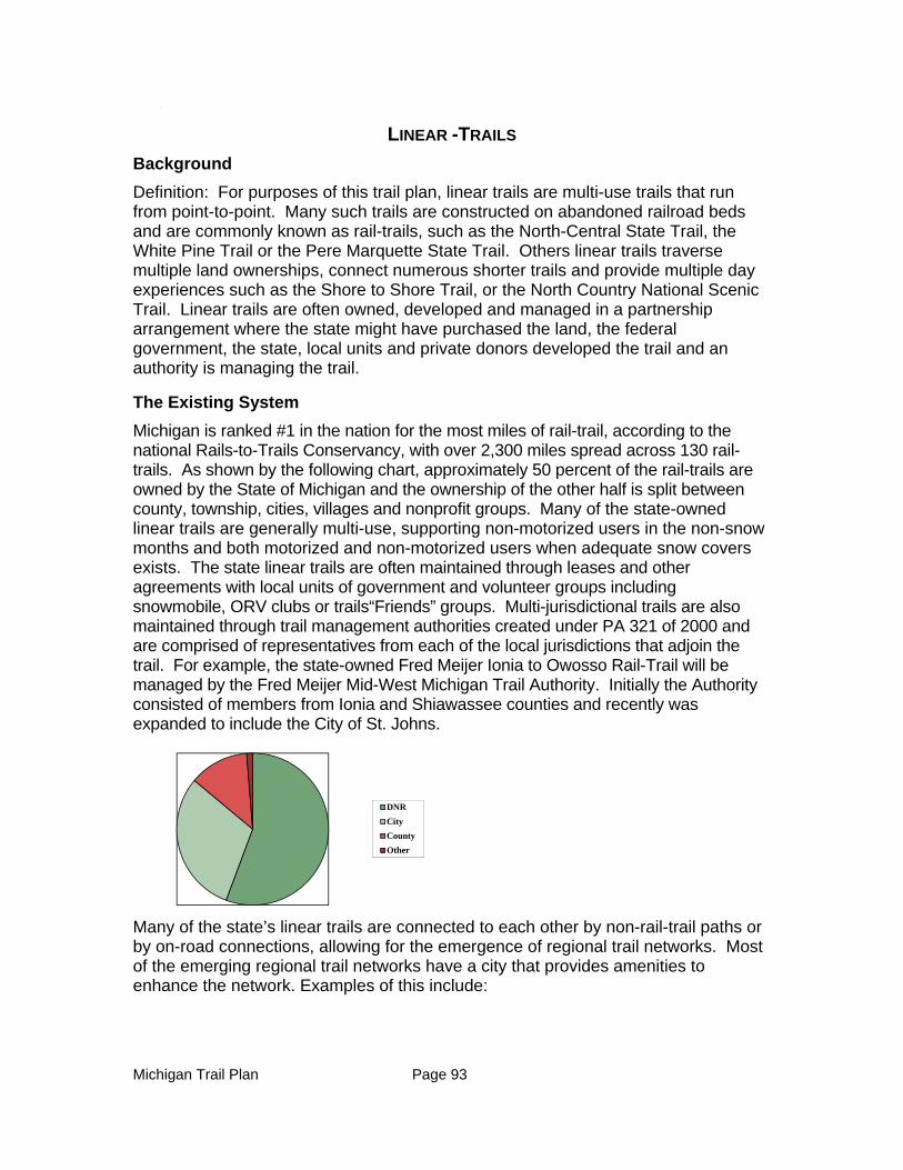
Michigan Trail Plan Page 93
1.
LINEAR -TRAILS
Background
Definition: For purposes of this trail plan, linear trails are multi-use trails that run from point-to-point. Many such trails are constructed on abandoned railroad beds and are commonly known as rail-trails, such as the North-Central State Trail, the White Pine Trail or the Pere Marquette State Trail. Others linear trails traverse multiple land ownerships, connect numerous shorter trails and provide multiple day experiences such as the Shore to Shore Trail, or the North Country National Scenic Trail. Linear trails are often owned, developed and managed in a partnership arrangement where the state might have purchased the land, the federal government, the state, local units and private donors developed the trail and an authority is managing the trail.
The Existing System
Michigan is ranked #1 in the nation for the most miles of rail-trail, according to the national Rails-to-Trails Conservancy, with over 2,300 miles spread across 130 rail-trails. As shown by the following chart, approximately 50 percent of the rail-trails are owned by the State of Michigan and the ownership of the other half is split between county, township, cities, villages and nonprofit groups. Many of the state-owned linear trails are generally multi-use, supporting non-motorized users in the non-snow months and both motorized and non-motorized users when adequate snow covers exists. The state linear trails are often maintained through leases and other agreements with local units of government and volunteer groups including snowmobile, ORV clubs or trails“Friends” groups. Multi-jurisdictional trails are also maintained through trail management authorities created under PA 321 of 2000 and are comprised of representatives from each of the local jurisdictions that adjoin the trail. For example, the state-owned Fred Meijer Ionia to Owosso Rail-Trail will be managed by the Fred Meijer Mid-West Michigan Trail Authority. Initially the Authority consisted of members from Ionia and Shiawassee counties and recently was expanded to include the City of St. Johns.
Many of the state’s linear trails are connected to each other by non-rail-trail paths or by on-road connections, allowing for the emergence of regional trail networks. Most of the emerging regional trail networks have a city that provides amenities to enhance the network. Examples of this include:
DNR
City
County
Other
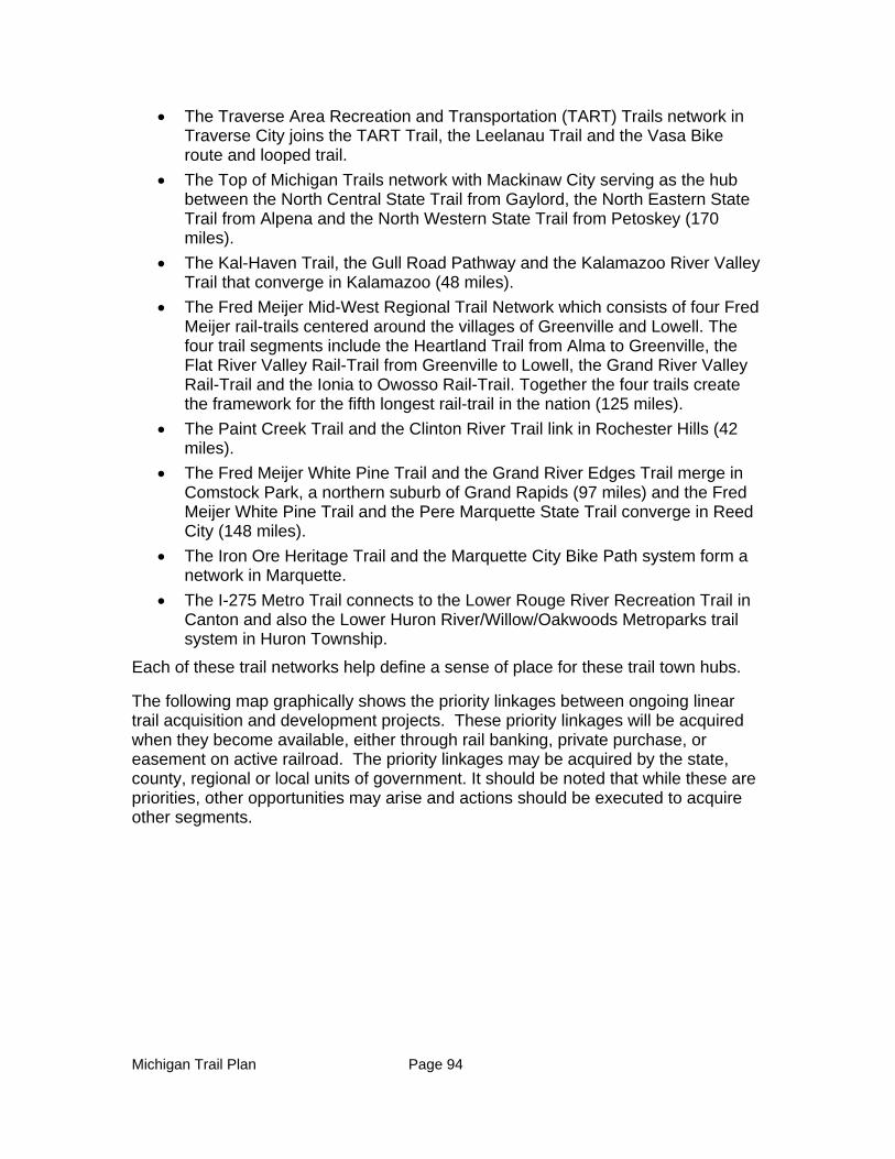
Michigan Trail Plan Page 94
The Traverse Area Recreation and Transportation (TART) Trails network in Traverse City joins the TART Trail, the Leelanau Trail and the Vasa Bike route and looped trail.
The Top of Michigan Trails network with Mackinaw City serving as the hub between the North Central State Trail from Gaylord, the North Eastern State Trail from Alpena and the North Western State Trail from Petoskey (170 miles).
The Kal-Haven Trail, the Gull Road Pathway and the Kalamazoo River Valley Trail that converge in Kalamazoo (48 miles).
The Fred Meijer Mid-West Regional Trail Network which consists of four Fred Meijer rail-trails centered around the villages of Greenville and Lowell. The four trail segments include the Heartland Trail from Alma to Greenville, the Flat River Valley Rail-Trail from Greenville to Lowell, the Grand River Valley Rail-Trail and the Ionia to Owosso Rail-Trail. Together the four trails create the framework for the fifth longest rail-trail in the nation (125 miles).
The Paint Creek Trail and the Clinton River Trail link in Rochester Hills (42 miles).
The Fred Meijer White Pine Trail and the Grand River Edges Trail merge in Comstock Park, a northern suburb of Grand Rapids (97 miles) and the Fred Meijer White Pine Trail and the Pere Marquette State Trail converge in Reed City (148 miles).
The Iron Ore Heritage Trail and the Marquette City Bike Path system form a network in Marquette.
The I-275 Metro Trail connects to the Lower Rouge River Recreation Trail in Canton and also the Lower Huron River/Willow/Oakwoods Metroparks trail system in Huron Township.
Each of these trail networks help define a sense of place for these trail town hubs.
The following map graphically shows the priority linkages between ongoing linear trail acquisition and development projects. These priority linkages will be acquired when they become available, either through rail banking, private purchase, or easement on active railroad. The priority linkages may be acquired by the state, county, regional or local units of government. It should be noted that while these are priorities, other opportunities may arise and actions should be executed to acquire other segments.
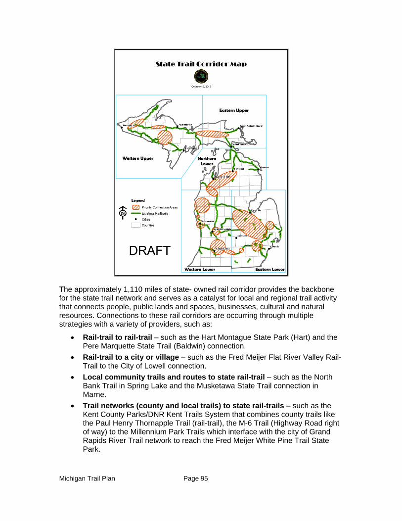
Michigan Trail Plan Page 95
The approximately 1,110 miles of state- owned rail corridor provides the backbone for the state trail network and serves as a catalyst for local and regional trail activity that connects people, public lands and spaces, businesses, cultural and natural resources. Connections to these rail corridors are occurring through multiple strategies with a variety of providers, such as:
Rail-trail to rail-trail – such as the Hart Montague State Park (Hart) and the Pere Marquette State Trail (Baldwin) connection.
Rail-trail to a city or village – such as the Fred Meijer Flat River Valley Rail-Trail to the City of Lowell connection.
Local community trails and routes to state rail-trail – such as the North Bank Trail in Spring Lake and the Musketawa State Trail connection in Marne.
Trail networks (county and local trails) to state rail-trails – such as the Kent County Parks/DNR Kent Trails System that combines county trails like the Paul Henry Thornapple Trail (rail-trail), the M-6 Trail (Highway Road right of way) to the Millennium Park Trails which interface with the city of Grand Rapids River Trail network to reach the Fred Meijer White Pine Trail State Park.
Michigan Trail Plan Page 96
The shorter connections in and around urban areas are often the most difficult segments to complete. Railroad corridors are typically not an option for development as a connection between a linear trail and to a community and the use of other methods are required to achieve connectivity including the use of utility corridors, road rights-of-way, easements over private lands and even side paths. These connections are often more difficult to acquire because of multiple ownerships. It is difficult to identify priority connections because of the vast number of connections that could link rail-trails to communities, natural or cultural areas, or other recreation opportunities. It is possible, however, to create criteria to help make strategic decisions about the importance of a proposed connection.
Multi-use Rail-Trails
Linear trails support a variety of recreational uses determined by a number of factors including but not limited to local preferences, information collected through a master planning process involving trail user input, topographical and resource based limitations, and funding availability. Biking, walking, running and cross-country skiing are typically allowed on most trails, whereas snowmobiling, horseback riding, ATV riding, and rollerblading occur where conditions permit. The majority of the rail-trail miles in the Upper Peninsula are used primarily by the motorized community. Many of the miles in the Lower Peninsula have been acquired and are being developed for non-motorized use with snowmobiling permitted when adequate snow falls during the winter season. Most of the state rail-trail miles are available for shared equestrian use or alongside the improved corridor where site conditions are favorable.
Other Linear Trails
The North Country National Scenic Trail - Michigan is home to the longest segment, at 1,150 miles, of the North County National Scenic Trail (NCT) that goes from New York to North Dakota. The vision for the NCT is to connect the Appalachian Trail to the Lewis and Clark Trail, which connects to the Pacific Crest Trail. The NCT is designed to go through scenic locations, public parks and public lands. Of the 1,150 miles, 750 miles are complete and 400 miles of trail are yet to be developed. Most of those 400 miles are located near urban centers where there is the least amount of available public land. The NCT connects many of Michigan’s prime natural, historic and cultural resources.
The Shore to Shore trail is a 220-mile trail running from Empire on the west coast of the Lower Peninsula to Oscoda on the east coast of the Lower Peninsula. There is also a north-south spur that runs from Cadillac to the Mackinac Bridge. The trails are managed by the Michigan Trail Riders Association, Inc., a statewide equestrian organization. The trail runs through federal, state and privately-owned lands and has trailside campgrounds spaced a day’s trail ride apart. The Shore to Shore Trail is also available for hikers.
Sleeping Bear Heritage Trail- When completed, the 27-mile trail will run from the southern edge of Leelanau County through the Sleeping Bear Dunes National Lakeshore to Good Harbor Bay. The first four-mile section between Glen Arbor and the Dune Climb is completed. Trail development was funded through a series of
Michigan Trail Plan Page 97
Federal Highway Administration Grant Programs targeted for transportation enhancement of federal public land and through individual contributions.
Midland to Mackinac- The 200-mile trail follows the path of an historic Native American trail. The trail stretches from Midland County to the Straits of Mackinac. It is managed and maintained by the Midland to Mackinac Trail Council and was restored by the Lake Huron Area Council No. 265 of the Boy Scouts of America. The trails winds through both state and national forests. It is available only for hiking, except when the trail overlaps with a multi-use trail.
New Linear Trail Initiatives
Michigan Trails and Greenway Alliance with the assistance of the Kresge Foundation is working on developing five shore to shore linear trails by connecting multiple linear trail routes. The Great Lake to Lake Trail Route 1 primarily uses the route of the former Michigan Airline Railroad and is linking up 15 existing rail-trails with on-road route connectors from South Haven to Port Huron. This developing route is 55 percent complete and many counties, cities, and townships are working on making the connections. The Great Lake to Lake Trail Routes Two and Three are more than 75 percent complete. The last two routes, Great Lake to Lake Trail Routes Four and Five utilize snowmobile routes at this time, so community engagement is necessary to get the project initiated in the Upper Peninsula. While the Great Lake to Lake Trails in the Lower Peninsula are east-west routes, existing north-south oriented trails in between Routes One and Two could provide connections between these routes, eventually forming a significant looped route in the Lower Peninsula.
Governor Snyder in his 2013 Energy and Environment message called for the creation of a hiking/biking trail that would connect Belle Isle Park in the City of Detroit to the Wisconsin border near Ironwood Michigan. This visionary 924- mile trail will incorporate existing trails, like the North Central State Trail with an additional 240 miles that would need to be developed. Similar to the entire trail system, this new trail would be a collaborative effort between the state, local units of government, nonprofits and private landowners.
Funding the System
The Michigan Trailways Act of 1994 created the Michigan Trailways Program, laying the foundation for state involvement in the creation of an interconnected statewide system of linear trails. The DNR and the Michigan Department of Transportation have both recognized the tremendous recreational, health, transportation, and economic outcomes that result from the conversion of the inactive railroad corridors into multi-use trails. Together, they have supported the state’s many miles of linear trails now in place. A variety of state and federal grant sources have provided a majority of the acquisition and development funding for the state trails network. Since its inception, the Michigan Natural Resources Trust Fund has contributed over $160 million for state and local trail projects. The Recreation Trails Program and the Transportation Enhancement program, federal programs managed at the state level, have contributed over $133 million to the mix of funding. The local match provided by a variety of sources completes the typical funding scenario for most trails. For example, the Southeast Michigan Greenways Initiative managed by the Community
Michigan Trail Plan Page 98
Foundation for Southeast Michigan raised $25 million from foundations and private contributions to leverage over $50 million of matching public investment. Similarly, the West Michigan Trails and Greenways Coalition, a non-profit regional trail organization has been able to harness a significant number of federal and state grants by providing the required match from foundation and individual contributions. The Meijer Foundation has played a key role in providing local match for the “Fred Meijer” trails within the West Michigan Trails network. The Meijer Foundation has also invested in the ongoing care and maintenance of several of its funded rail-trails through a multimillion dollar endowment fund. This fund, managed by the Grand Rapids Community Foundation and dispersed by the Fred Meijer Midwest Michigan Trail Authority will provide the dollars necessary for basic upkeep. Supplemental activities and additional maintenance will be provided by friends groups and the local units of government based on the local desire and resources available for trail care.
Planning for Linear Trails
Multiple state agencies and recreational stakeholder groups collaborated on two separate trail planning initiatives that helped advance the state’s trail system. First, under the leadership and direction of the Michigan Trails and Greenways Alliance (MTGA) Connecting Michigan: A statewide trailways vision and action plan was initiated at a trail summit in April of 2006. This broad-based initiative brought together trail planners, advocates and recreational users throughout Michigan for a yearlong process to identify and address critical issues that were impeding progress in the development of a statewide interconnected system of trailways. Nine task forces were formed to address:
Trailway Funding
Database and Website
Property Issues
Trail Usage
On-Road Connections
Building Support for Trailways
Overcoming Boundaries
Coordinating Resources
Multi-Use Trails and Design
Trails in a Statewide Context
A complete copy of the report including a history of Michigan trailways, studies and action plans for the nine topic areas that identified 39 goals and 109 action steps and an implementation strategy is included as Appendix 3.
A second trail planning initiative, Michigan at the Crossroads: A Vision for Connecting Michigan, developed by the DNR in collaboration with the Michigan Department of Transportation was completed in the spring of 2007. This report summarized the importance of the state trail network and the opportunities, challenges and suggestions for advancing Michigan’s trail agenda. The complete report is included as Appendix 4.
Michigan Trail Plan Page 99
Developing a statewide network of trails is an evolving dynamic process. Much has been accomplished and yet there is even more to do. State agencies in partnership with local communities, volunteer groups, nonprofits, and businesses are continuously working together to foster the vision of Michigan as The Trail State, leaving an incredible legacy for future generations.
A Vision for the Future
The vision is for a well-maintained interconnected system of multi-use trails that are within five miles of 90 percent of Michigan citizens.
Michigan is now in the enviable position of being able to connect many of its linear trails creating both long-distance and/or multi-directional continuous trail networks. It will take partners at all levels, from federal, state, regional, local and individuals as well as funding from all possible private and public sources to complete. Connections between multi-use trails can happen through off-road trails where favorable conditions exist (right-of-way width, public ownership or favorable private ownership for trail easements and topographical factors, such as wetlands, driveway crossings, etc. are minimal or through on-road facilities, such as bike lanes, wide shoulders, signed low-traffic roads. For example, another interconnected route is emerging within mid-Michigan with the recent acquisition of the abandoned rail corridor between Greenville and Ionia. Together with the Fred Meijer Heartland Trail and the Fred Meijer Ionia to Owosso Rail-Trail, the network currently forms somewhat of a giant “C”. Connecting the Fred Meijer system to the Saginaw Valley Rail-trail to the northeast and to the Flint River Trail to the east could form another complete trail loop in Mid-Michigan. Further, connections to the Fred Meijer White Pine Trail to the west could tie this regional system into the West Michigan trails network.
The Michigan Department of Transportation (MDOT) is concluding a multi-year statewide non-motorized transportation planning effort. Four of the seven MDOT regions have completed a non-motorized strategy to help guide regional trail connections. MDOT has completed regional maps of existing trails and select attributes that influence on-road bicycling as a trail connection. “The maps enable citizens to make non-motorized transportation choices. The MDOT regional non-motorized planning processes also included community engagement summits. Citizens voiced their desires for non-motorized connections on road corridors which were registered in a non-motorized transportation plan. High priority proposed non-motorized routes were indicated for each region to take forward into state transportation planning processes. Currently the MDOT Metro Regions and three counties in the University Region adjacent to the Metro Region are undergoing the community engagement process. The priority linkages proposed in each region should be weighed carefully in consideration of state trail plan priorities for non-motorized trails. The results from this planning effort can be found on the MDOT website under Projects and Programs: Non-motorized: http://michigan.gov/mdot/0,4616,7-151-9621_11050---,00.html
Many cities, villages, and townships have been working together to develop regional trail networks through the implementation of local non-motorized transportation
Michigan Trail Plan Page 100
plans. Both trail connections and on-road non-motorized accommodations help to close the gaps between destinations, such as parks, neighborhoods, shopping districts, and other attractions. In some areas, “Complete Streets” policies, which require that transportation planners consider implementing non-motorized transportation priorities as transportation improvements and upgrades are made, are helping to close gaps between destinations. A number of Michigan’s cities, villages, and townships have adopted Complete Streets resolutions, ordinances, or administrative language. Local jurisdictions are working in tandem with parks and recreation, public works, and planning departments as well as county road commissions in conjunction with state and local funding partners to make these connections complete.
The Michigan State Parks and Outdoor Recreation Blue Ribbon Panel recently released its report, with one of the recommendations being to tie Michigan’s state parks to nearby cities, villages and other attractions through the use of trails and non-motorized routes. One such opportunity exists to tie Hartwick Pines State Park, Higgins Lake State Park, and Otsego State Park together with the Grayling Bicycle Turnpike and the resulting interconnected network, to Mackinaw City via the North Central State Trail.
Threats
By interconnecting trails as outlined above and employing the use of Complete Streets and other best practices to provide connections for biking and walking, Michigan can further elevate its #1 trail state status and maximize the resulting benefits of recreation, transportation, fitness, and economic development. The more trails are linked to each other and to destinations, the more useful they become and the more accessible they are for the majority of citizens in the state. However, there are several critical issues which impede progress towards this vision.
Over $300 million in funding from the Natural Resources Trust Fund through the DNR and the federal Transportation Enhancement program through the MDOT have been instrumental over the past thirty years in acquiring and developing the Michigan trail system. Trail funding has recently been significantly diminished due to legal restrictions and federal legislative changes. The available funding for trail projects through both programs has been reduced by approximately 30 percent; therefore, the need for new and/or increased funding sources is necessary to complete priority connections. The Michigan Trailways Fund, which still exists in state law and is designed to capture revenues from potential concessions along state trails and from utility easements, has not received funds to any useful extent. Recently enacted legislation reduces payments into this fund as internet providers were given reduced rates to install internet connections in trail corridors.
Lack of maintenance funding- One of the major obstacles faced by local jurisdictions that desire trails for their citizens is the lack of maintenance funding. A trail study conducted by Public Sector Consultants in 2007 showed that trail maintenance is carried out by an array of partners, ranging from individual trail advocacy groups, trail user groups, local public works or parks and recreation departments. It was also found that depending on the
Michigan Trail Plan Page 101
use of volunteer labor and the standards for trail maintenance (ranging from low to high), the cost for upkeep of trails can range anywhere from $800 per mile to $3,500 per mile (urban areas usually demand more attention, resulting in a higher cost/mile).
Transportation Planning Processes – While many communities have adopted local Complete Streets policies, there is a gap between locals adopting Complete Street policies and taking the next steps toward implementation. There is concern that many road project opportunities for addressing non-motorized priorities and concerns could fall between the cracks until the policy is activated through routine transportation planning policies and procedures.
Prioritize and coordinate funding - As the draft 2013-17 Statewide Comprehensive Outdoor Recreation Plan has indicated, Michigan citizens have voiced their desire for more trails and elected officials are striving to meet the demand. Trail projects should be given top priority for state and federal funding consideration. There is currently no consensus between trail funding sources on criteria with which to make trail funding decisions and local stakeholders are left to their own devices to position their project to maximize their opportunity to receive a grant.
Lack of information for trail users – Information on trails is scattered on various individual trail websites and on some local government websites. Basic information on state-owned trails is on the DNR website, but it is not comprehensive. The Michigan Trails and Greenways Alliance has an interactive geographic trail database and map on their website that is not complete. MDOT’s regional trail maps available in print and online are the most comprehensive in terms of existing trails and on-road connections for the non-motorized trail system, excluding looped trails, water and equestrian trails. Still, the existing sources of trail information are incomplete and lacking integration with other trail tourism information is needed to plan a trail adventure from start to finish. There is a need for a central comprehensive trail website offering user-friendly information on all types of trails and how to get there as well as trail events, nearby travel amenities, such as restaurants and hotels, and other information needed to encourage their use. The “Up North Trails Initiative”, a 22-county effort led by the Land Information Access Association in conjunction with the Northeast Michigan Council of Governments and the Northwest Michigan Council of Governments in conjunction with stakeholder groups, offers the best prototype (modeled after the “Discover US Heritage Route 23” site www.us23heritageroute.org) for providing this needed information, with an integrated database and website, as well as customized itinerary-building capacity, but funding it has been a long and arduous process. Michigan is losing trail tourism visits and the resulting tourism revenue because of this lack of access to information.
Pure Michigan has recently launched a revised Michigan.org web site that is intended to meet the needs of the traveling public by allowing them to locate their destination or activity and then find out about amenities or recreational opportunities associated with their destination and activity. Pure Michigan is
Michigan Trail Plan Page 102
working closely with the DNR and trail partners to ensure that the website meets the need for marketing Michigan’s trail system.
Priorities/Goals (five- year):
MSTAC should identify criteria for determining the priority linear trail connections for purposes of directing limited development funds.
Interim on-road connections should be identified for the gaps within major trail initiatives that can be utilized until permanent trail corridors are acquired and developed.
The five Great Lake to Lake Michigan trail routes should identified and promoted
Maintenance plans should be developed for all state-owned linear trails with a maintenance funding source identified in each plan.
Trail town plans should be established for each state-owned and managed linear trail
Get at least 50 percent of towns along linear trails adopt Complete Street resolutions or ordinances and 75 percent of those adopt non-motorized plans incorporating the feeder routes to the trails.
Create a central comprehensive trail website offering user-friendly information on all types of trails and how to get there as well as trail events, nearby travel amenities, such as restaurants and hotels, and other information needed to encourage their use.
A variety of programs encouraging trail usage should be taking place on at least 50% of all state-owned trails.
A statewide trail classification system should be created for multi-use trails to help ensure consistency in development and user information and expectations.
The Belle Isle to Ironwood hiking/biking trail should be completed.

Michigan Trail Plan Page 103
CHAPTER 5 - WATER TRAILS
Definition
Water trails are recreational routes on waterways with a network of public access points supported by broad-based community partnerships. Water trails provide both conservation and recreation opportunities.
Background and History of Water Trails in Michigan
With Michigan’s 10,000 miles of rivers and streams, hundreds of inland lakes and the largest freshwater coastline in the world, there are endless opportunities for establishing a spectacular water trail system in Michigan. Much of the framework for such a system already exists. For example, there is significant infrastructure in place to support such a statewide trail system, including many locally designated water trails with access sites, harbors of refuge, waterside campsites, paddling guides and boat liveries. What is missing is an accepted statewide criteria for designating a trail so that a water trail user can know what to expect on a trail, including level of difficulty, distance between access sites and trail amenities such as campgrounds, restaurants, or restrooms. There are, however, several on-going initiatives to designate local water trails in the state as well as an effort to coordinate at the state level and in cooperation with neighboring states.
Michigan Heritage Water Trails
PA 454 of 2002 called for the Great Lakes Center for Maritime Studies at Western Michigan University, in conjunction with former Michigan Department of History, Arts and Libraries (now DNR History Division) and the Michigan 4-H Youth Conservation Council to develop a statewide program called the "Michigan Heritage Water Trail Program." The act required the recognition of private property rights while completing the following:
Establish a method for designating significant water corridors in the state as Michigan heritage water trails.
Provide recognition for the historical, cultural, recreational, and natural resource significance of Michigan heritage water trails.
Establish methods for local units of government to participate in programs that complement the designation of Michigan heritage water trails.
Heritage water trails are routes on navigable waterways designed and implemented to allow an interactive experience between the water trail and the historical events that occurred along the trails. Historical markers posted on bridge crossings highlight historic events or themes related to the waterway. A companion guide provides a more detailed presentation of the historic material in addition to acting as a conventional water trail guide with maps, access points, rest stop locations, paddling conditions, etc. An interpretive program and exhibit at a local museum on or nearby the water trail may also be part of the experience. A website is in place which allows users to plan and select paddling routes and gain access to information on amenities on and near the rivers. Four rivers or river segments have been designated as Michigan Heritage Water Trails:
Michigan Trail Plan Page 104
River Country Heritage Water Trail, (St. Joseph County)
Bangor/South Haven Heritage Water Trail, (Van Buren County)
Tip of the Thumb Heritage Water Trail, (Huron, Tuscola and Sanilac Counties)
Kalamazoo Watershed Heritage Water Trail
MI Great Lakes Coastal Water Trails
In 2010, Michigan Sea Grant, in collaboration with Michigan’s Coastal Zone Management Program, gathered together a visionary group of volunteers from all over the state — people who work with coastal communities to develop water trails and love the Great Lakes – to create the MI Great Lakes Water Trails Advisory Council (The Council). The Council is an ad-hoc collection of volunteers from local, regional and state organizations who are concerned about the sustainability and resilience of Michigan’s coastal communities. These volunteers coalesced around the idea of a statewide system of contiguous regional water trails along Michigan’s Great Lakes coasts and connecting waters. Such a system will provide a framework to more effectively share information and coordinate marketing efforts for visitors and residents interested in accessing Michigan’s spectacular shoreline, which will promote sustainability, tourism, recreation and related economic development in coastal communities. he Council’s formation was a direct result of the momentum created by local trail groups and their work with Michigan’s Coastal Zone Management Program (CZM). CZM has been actively involved in the creation of locally-designated water trails, providing funding and technical expertise to those seeking assistance since 2005.
MDEQ Coastal Zone Management Program - Currently funded water trail projects:
2012
The Land Information Access Association (LIAA) is currently working with the Michigan Great Lakes Water Trails Advisory Council (an ad-hoc collection of volunteers from local, regional and state organizations driven under the leadership of Michigan Sea Grant) to promote public access by linking regional water trails to form a statewide water trail system along every mile of the Great Lakes shoreline. A statewide repository for all coastal water trail resources will improve the sharing of information between regions, heighten awareness of coastal access availability and increase visibility and marketability of local trails to a broader audience. This project will facilitate the development of technical and data resources that are necessary to support the statewide effort and help to continue the work of establishing coastal trails where gaps remain.
Western Michigan University is currently working on a project which is focused on implementing, monitoring, and evaluating a National Recreation Water Trail on Lake Michigan. The scope of work includes inventorying Lake Michigan sea kayak access points, meeting with local agencies, visitor info centers, and the public, determining long-term viability of launches in view of future climate change and changing lake levels, designing websites for trip planning and hosting a Lake Michigan Water Trail Conference which occurred in the fall of 2012.
Michigan Trail Plan Page 105
2011
Eastern U.P. Regional Planning and Development Commission received a grant to promote the economic and aesthetic value of the North Lake Huron shore. This project involved the creation of a web-based North Lake Huron Blueways & Greenways Guide that details information on trails, kayak and boat access sites and other recreational opportunities within the coastal zone of Lake Huron, from St. Ignace to Drummond Island. The North Lake Huron shore contains a vast amount of ecological resources; providing access to marshes, beaches, sand dunes, coastal forests, wetlands, and other areas containing habitat for many rare and endangered species. The Les Cheneaux Islands also deliver high-quality coastal scenery and aesthetics providing for a wide variety of paddle and boating adventures, eco-tourism potential and year-round opportunities for silent sport enthusiasts. This project was a collaborative effort that utilized existing information from several initiatives and organizations including the M-134 Heritage Route, North Huron Scenic Pathway Committee, Great Waters Tourism Association, and the Little Traverse Conservancy. The deliverable product is an interactive web site, www.lakehuronrec.com, which uses text, pictures, graphics, animations, and maps to provide an overall experience of the entire area to immerse a person in the natural beauty of this coastal region and provide useful information on the coastal recreation opportunities within the northern Lake Huron Region.
The Western Upper Peninsula Planning & Development Region received a grant to create a water trail plan and guide that encompassed the coastal regions of Gogebic, Ontonagon, Houghton, Keweenaw, and Baraga Counties. The project consisted of three primary components: A public Access Plan, an Interactive Website and User Guide and an Outreach Campaign which can be found at www.paddlelakesuperior.org
The Public Access Plan consists of a detailed inventory and evaluation of existing public access opportunities, identification of potential land/water trail connections to further existing water trail efforts along the Lake Superior shore, and prioritized public access enhancement and sensitive environmental protection projects. This plan can now be used to assist the western region of the Upper Peninsula to better plan for the protection and management of its coastal resources by coordinating efforts across jurisdictions. This Plan brought stakeholders and water trail users together resulting in a coordinated regional plan. The project also ties directly to existing water trail efforts in Wisconsin and to the Hiawatha Water Trail in Marquette and Alger Counties.
The Interactive Website and User Guide assists in promoting coastal tourism opportunities, enhancing the user experience and promoting responsible coastal recreation and stewardship. It allows the public to easily explore coastal recreation and access opportunities on a regional basis while learning about protection efforts. This information is available for online viewing as well as by download for easy hard copy reproduction.
An Outreach and Promotional Campaign was completed which will utilize press releases and social media in order to heighten awareness of coastal resources
Michigan Trail Plan Page 106
and water trail opportunities and to promote widespread use of the products developed through this project.
The West Michigan Shoreline Regional Development Commission (WMSRDC) received a grant to undertake Phase II of a study for greenways and blueways (water trails) along the Lake Michigan shoreline in Oceana and Mason Counties. In 2009, CZMP funded Phase I of this study in Muskegon County. Both projects addressed three components: inventory, describe and map linkages of existing greenways and blueways (water trails), and a set of recommendations and implementation schedule to improve public access through greenways and blueways (water trails).
2010
The Northeast Michigan Council of Governments (NEMCOG) received a grant to develop a web-based guide of northeast Michigan coastal trails, parks, public access sites, historic and natural points of interest, and other features located in Cheboygan, Presque Isle, Alpena, Alcona, and Iosco Counties. In 2008, NEMCOG also received a grant from the CZM to survey, research, and map the water trail information (access points, distance between access points, hazards, points of natural, historical, and cultural interest along the routes, etc.) for this northeast Michigan shoreline. This 2010 project furthers this effort through the development of a web-based atlas and hardcopy brochure with maps of northeast Michigan coastal trails, public access sites, historic and natural points of interest, and other features that promote the coast as a recreational tourist destination.
The US-23 Heritage Route Management Council was a project partner for both projects and served as an ad hoc advisory committee. Therefore, the web-based atlas, www.us23heritageroute.org, was incorporated in the US-23 Heritage Route tourism website.
St. Clair County received a grant to develop a comprehensive water trail system along the St. Clair River corridor, from Lake St. Clair at the southern border to the northern border of the county along Lake Huron. The project involved GIS mapping of access points; identification of paddling routes and sensitive environments; development of a water trail plan and the development and implementation of interactive multi-functional website and mobile website (www.bluewaysofstclair.org)
2005
Metropolitan Affairs Coalition received a grant to develop the first planned Heritage Water Trail for Southeast Michigan, allowing kayakers and canoeists to paddle on and enjoy the unique natural resources and history of the Detroit, Huron, Raisin, and Rouge Rivers. The Heritage Water Trail Plan included: creation of a regional water trail vision that identifies potential water corridors; and the development of a detailed implementation plan for the first phase to serve as a demonstration project for subsequent phases. Phase I includes the Huron River (mouth to the City of Flat Rock) and the Detroit River (Pte. Mouillee to Elizabeth Park-Trenton).
Michigan Trail Plan Page 107
Western Michigan University received a grant for a Heritage Water Trail along the shoreline of Tuscola and Huron Counties. Heritage water trails are routes on navigable waterways such as rivers, lakes, and canals that are designed and implemented to foster an interactive historical education experience. Michigan Public Act 454 of 2002 directed the Great Lakes Center for Maritime Studies at Western Michigan University, in conjunction with the Michigan Department of History, Arts and Libraries and the 4-H Youth Conservation Council to develop a statewide recognition program called the "Michigan Heritage Water Trail Program." The Huron Coastal Heritage Water Trail served as a pilot program for the development of a planning model to design and implement coastal heritage water trails in Michigan. The project team worked with local, county, state, and tribal authorities on the Lake Huron shoreline in Huron and Tuscola counties to plan and implement a coastal heritage water trail.
Vision of what a quality system would look like:
Michigan’s water trail system reflects the abundance of water that defines the state. Citizens and visitors are able to explore our coastlines and navigable waters through geographically dispersed water trails that offer a diversity of experiences including lengths, scenery, challenges and amenities while:
Increasing access to outdoor recreation on shorelines and waterway.
Becoming a catalyst for protecting and restoring the health of local waterways and surrounding lands.
Offering users opportunities to learn about the value of water resources, cultural heritage, boating skills, and outdoor ethics.
Providing the public with accessible and understandable water trail information, including details for identifying access and trail routes; cultural, historic, and natural features; hazards; and water quality.
Having support from local communities and user groups to help maintain and steward the water trail system.
Existing Locally Designated Trails:
Bangor/South Haven Heritage Water Trail
Blueways of St. Clair
Detroit Heritage River Water Trail
Grand River Heritage Water Trail
Hamlin Lake Water Trail-within Ludington State Park
Huron River Water Trail
Huron Shores Coastal Water Trail
Isle Royale National Park Water Trail
Kalamazoo Watershed Heritage Water Trail
Keweenaw Water Trail
Lake St. Clair Coastal Water Trail
Les Cheneaux Water Trail
Looking Glass River Trail
Michigan Trail Plan Page 108
Ludington State Park Canoe Trail
River Country Heritage Water Trail
The Hiawatha Water Trail
The Shiawassee River Heritage Water Trail
Tip of the Thumb Water Trail
Current Activities:
A. Ongoing Water Trail Activities:
Sleeping Bear Dunes National Lakeshore is working to develop a 30- mile route along Lake Michigan with access to backcountry camping.
West Michigan Shoreline Regional Development Commission is working on a blueways and greenways plan for the west Michigan area. Currently they are focusing on identifying public access, amenities, and ownership.
Planning is underway to create a quad-state Lake Michigan tri-modal loop allowing biking, paddling or driving around Lake Michigan. Organizations in the states surrounding Lake Michigan are working to develop this trail in their own state utilizing in most cases existing corridors. Western Michigan University is taking the lead for Michigan and recently sponsored a two day conference to review this trail opportunity.
East Michigan Council of Governments has proposed and sought funding to create a Saginaw Bay Water Trail that would fill the gap between the Huron Shores Coastal Water Trail and the Tip of the Thumb Water Trail.
The Eastern U.P. Regional Planning and Development Commission has completed an assessment of access points and is seeking funding to develop a water trail map along the eastern shores of Lake Superior, St. Mary’s River and into Lake Huron.
In June of 2011, The Lake Michigan Water Trail, 75 miles from Chicago, IL to New Buffalo MI, was designated a National Recreation Trail by the US Department of Interior. This section is part of a larger vision for a nationally designated water trail around the entirety of Lake Michigan.
B. Funding Opportunities for Water Trails under the CZMP
The Coastal Zone Management (CZM) Program provides grant funds to coastal communities and partners to further the CZM Program objectives of protecting and restoring healthy coastal ecosystems, including fish and wildlife habitat; creating and enhancing public access to the Great Lakes and coastal resources; preserving historic maritime structures; revitalizing urban waterfronts; minimizing the loss of life and property in areas vulnerable to coastal hazards including erosion, floods, and dangerous currents; and increasing recreational opportunities along Michigan's Great Lakes coast. These grant funds are made available by the National Oceanic and Atmospheric Administration (NOAA), pursuant to the Coastal Zone Management Act (CZMA) of 1972.
Michigan Trail Plan Page 109
The Great Lakes are a primary focus for recreation and tourism in Michigan. The CZM Program protects, restores, creates and enhances public access to the Great Lakes using approaches that support coastal communities and fosters appreciation of our natural resources. The CZM Program is committed to providing public access to the Great Lakes for recreational use through planning, design, engineering and construction projects.
A Request for Proposals (RFP) is announced annually in January with an application submittal deadline for funding in the upcoming fiscal year. The maximum grant amount is $100,000 with a 1:1 match requirement. In addition, all construction projects must be within Michigan's coastal boundary that generally lies 1,000 feet inland from the ordinary high water mark of the Great Lakes. The RFP Application Package can be found at: http://www.mi.gov/coastalmanagement.
C. Trends
Nearly half of all Americans participated in some type of outdoor recreation in 2009, and 82% of this group planned to spend more time outdoors in 2010. Participation in kayaking has grown over the last few years, and now more Americans paddle (kayak, canoe, raft) than play soccer. Increased water trail access has become the catalyst for more awareness and opportunities that offer users a wide variety of experiences.
Adaptive Paddling: In 2006, The Kellogg Foundation announced a funding opportunity for communities to develop infrastructure as it relates to adaptive recreation. The Access to Recreation funding program was time-limited ending in 2010. As a result, several adaptive kayak launches have been developed and installed across the State. Examples of these launches can be found on the Detroit River and in St. Clair County. In addition to these launches, programming has begun to be developed to provide the users with a unique experience. Such partners as the Wounded Warrior Project, Special Olympics and Michigan Adaptive Sports are beginning to recognize these new launches as new opportunities.The success of these launches has led to many other water trail projects considering adaptability as a part of their program. As new trails are being developed, adaptive paddlesports and its impact for people of all abilities are being brought to the forefront of planning.
On-Water Events: Special events by local communities to create awareness of water resources are increasing public opportunities for organized use and programming of water resources. Michigan water trail planners are finding the need to do more regional collaboration with local non-profits and other organizations to conduct and promote on-water events. Many non-profits are working to provide paddling tours that highlight locally designated water trails and embrace stewardship, fundraising and partnerships. Unique paddle tours are increasing in popularity as paddlers seek to connect with history and natural resources. In addition, paddling tours for groups such as Rotary, Kiwanis and others offer opportunities to socialize in different
Michigan Trail Plan Page 110
settings.
Promotion: The Michigan No Child Left Inside Coalition has recognized paddlesports as an asset and has promoted the sport at their annual Day at the Capitol. Trail Town development is now gaining support from communities that are looking to build their front porch to the water. Water Towns are gaining momentum. Placemaking and Main Street initiatives place a special emphasis on water access. Partnerships between paddlesport providers and local businesses, such as restaurants, are becoming more prevalent.
Link to Economic Development
A. Business Opportunities
Community leaders and entrepreneurs throughout the state have long leveraged their proximity to Michigan’s coastlines and inland waterways to support local businesses and new opportunities for economic development. Whether it’s a historic fishing village in Leland or the Thomas Edison Inn in Port Huron, local business owners have realized the inherent benefits of being near our great waterways. Increasingly, local business owners are realizing the benefits of leveraging the vast array of opportunities supported by water trails. However, there are still opportunities for businesses that have not yet embraced water trails to do so. These business opportunities include:
Collaboration between water trail managers and communities adjoining the water trails could develop or grow businesses that support the use of the trail, such as kayak or canoe rentals, shuttle services, lodging and restaurants.
There are also business opportunities in planning events related to the water trails such as canoe races or triathlons utilizing neighboring hiking/running trails.
Many water trail users prefer to camp and private-owned or managed campgrounds would be an asset along trails.
Organized tours which would allow water trail enthusiasts to experience a variety of such trails presents opportunities. There is also a large and growing market for organized tours by national organizations such as Road Warriors or REI that might be interested in including water trails as part of their touring packages.
Coordinate with convention & visitors bureaus and Pure Michigan to promote Michigan’s water trails as a system of connected locally-designated trails.
B. Outfitters
Scores of canoe/kayak/float tube liveries adjoin rivers and lakes throughout the state offering expanded economic development opportunities. Examples include:
A new business in Indian River that provides guide service for kayaking the unique rivers of northern Michigan.
Michigan Trail Plan Page 111
New kayaking guide service to view the rock formations of Pictured Rocks National Seashore.
Silent Sports Lodge in Wolverine is promoting the multiple outdoor recreation opportunities in the area including kayaking/canoeing the Sturgeon and other nearby rivers.
The Port Austin Kayak and Bike Rental continues to add retail sites as the popularity of the Tip of the Thumb Heritage Water Trail continues to grow.
Visitors to the Detroit area can explore the waterways that led the Industrial Revolution on tours conducted by Riverside Kayak Connection.
International, national, state and local conference planners are working with kayaking outfitters to offer mobile workshops on water trails to conference attendees.
C. Trail Towns
Recreational trails provide many physical, economic, environmental and social benefits to a community. They can help encourage healthy lifestyles, bring customers into local businesses, protect wildlife habitats and promote a strong sense of community and place. As the number of recreational trails being built increases, it is important to understand how they fit into and shape our community identity. The basic Trail Town concept is simple: ensure that communities along the trail are better able to maximize the economic potential of trail-based tourism.
Many communities across Michigan are working to leverage their existing trail resources for community and economic development. However, only a handful of communities are exploring the creation of a Trail Town program. A regional approach to the Trail Town concept might be especially impactful to the collection of communities that have a natural waterfront.
Threats:
Since the water trail program is in its infancy, there is a real opportunity to plan, develop and manage the program to address the threats that could cause conflicts or impediments to growing the program. These potential threats include:
Lack of organized state government involvement in the development and designation of a statewide coordinated water trail system that connects and promotes locally-designated water trails
Potential conflicts between water trail users and anglers
Potential conflicts between paddlers and motor-boat users
Low and ever-changing water levels due to global climate change
Access sites might have been purchased with hunting or fishing license dollars or federal dollars that restrict use to those user groups
Lack of revenue to create a state water trail program
Lack of private sector infrastructure
Michigan Trail Plan Page 112
Priorities (five year)
The development of a water trail program offers significant opportunities for enhanced fun, exercise, nature appreciation and economic growth with minimal investment. Adopting challenging goals should help to drive the growth of this program and ensure that within five years a robust program is in place. Suggested five-year goals are:
30 percent of Michigan’s navigable waters have a designated water trail
Five connected lake system trails are officially designated
75 percent of the Great Lakes shoreline is designated as water trail
50 percent of Michigan’s designated water trails utilize the online database (statewide repository for water trail data developed with funding from CZMP)
Action Steps
Some of the actions steps that would need to occur to ensure reaching the goals include:
Adoption of standardized criteria on what minimum information is needed to be considered a state-designated trail
Inventory of potential trails that meet criteria
Official designation of water trails
Marketing and promotion campaign of designated trails
Design of an evaluation system to track progress Adoption of standards for signage that accommodate both river and lake-wide
water trails and respect the wishes of local property owners and governing bodies
Michigan Trail Plan Page 113
APPENDIX 1
2012 TRAIL USER SURVEY ANALYSIS
Conducted by the DNR
To inform on the development of the comprehensive trail plan required under Act 45 of 2010, the MSTAC and the DNR distributed an electronic survey to approximately 250 trail related organizations and individuals in August of 2012, requesting them to forward the survey to their membership and to others who are interested in Michigan’s trail system. The deadline for completing the survey was August 31. Approximately 4,500 (4,540 to date) people responded to the survey. Seventy-one percent of the respondents were male and approximately 50 percent were over 50 years of age and 27 percent were between 40 and 49 years of age. A copy of the survey, as well as more detailed responses, is attached.
The purpose of the plan is to identify a statewide trail network. This plan also documents the extensive trail network for motorized, non-motorized, equestrian and water trails in the state and identifies a strategic vision for each trail type with priority recommendations for reaching those visions. In addition, the plan identifies seven priority recommendations that should be implemented to assist in reaching the trail plan’s overall vision and ensure that Michigan’s trail system is nationally recognized because of the quality, quantity, and experiences that our trails and their host communities provide. The survey provided valuable information to ensure that priority recommendations and action steps meet the needs of the state’s trail users.
Key Findings of the Survey:
Participation by all trail user groups has stayed about the same over the last five years. Approximately 40 percent of hikers and off-road bikers indicated that their participation had increased with 28 percent of off-road biking and 21 percent of road bikers indicating that their participation had increased a lot.
Trail use increased because of new trail opportunities.
For those respondents whose trail use had declined, 20 percent indicated that the reason for the decline was because of having less time.
Eighty-three percent of the trail users’ primary purpose for using trails was for recreation with 16 percent indicating that they used trails for health or wellness benefits.
Eighty-three percent of the respondents rated the quality of their favorite trails as excellent or good.
Seventy-seven percent of the respondents rated the quantity of their favorite trails as excellent or good.
Forty-three percent of the respondents indicated that they liked to spend more than two hours but less than five hours on a trail.
Forty-one percent of the respondents indicated that it was extremely important to increase the number of trails anywhere in the state.
Sixty-five percent of the respondents indicated that they seldom had an interaction with other types of trail users that diminished their trail experience.
Michigan Trail Plan Page 114
Trail Use
The MSTAC and the DNR are interested in how often trail users enjoy their sport. Respondents were asked how often they enjoyed the different types of trails found in the state. Road bikers, off-road biking and hikers were the most frequent participants in their respective activities (40 percent of off- road bikers indicated they did this activity 20 days or more a year, 36 percent of those participating in road biking did so 20 days or more a year, and 33 percent of hikers indicated that they hiked more than 20 days a year). Twenty-four percent of the respondents indicated that they participated in road biking 50 days or more a year. Only 20 percent of the respondents indicated that they never hiked versus 70 percent of the respondents never participating in off-road vehicle activities. Nationally, the average number of outdoor outings per adult aged 25 and
older is just over 79 outings a year 1.
When asked whether their participation in their favorite trail activity had increased, decreased, or stayed the same, most respondents indicated that use had stayed the same or increased. Sixty percent of the road bikers, 59 percent of the equestrians, 56 percent of the off-road bikers and 50 percent of the snowmobilers indicated that their use had increased. Approximately 30 percent of the snowmobilers and off-road ATVs indicated that their use had declined.
The predominate reasons for all user groups that their use had increased was because friends or family had become more involved in the activity, new trail opportunities, or because they had “more time.”
Approximately 20 percent of the off-road bikers, on-road bikers, hikers, trail runners and cross country skiers indicated that they were more frequently hitting the trails to improve their health.
The main reasons for decreasing use were because the users had “less time” (20 percent), “lost interest in the activity” (16 percent) or had “less money to spend” (11 percent). Less time was the predominate reason for all trail-use groups, except side by side ATV users, full size ATV users, and trail runners, who indicated that loss of interest was the main reason that their use had declined.
Understanding why people are trail users helps the DNR and MSTAC determine marketing strategies. Most of the respondents utilized the trails to have fun, 15.5 percent also used trails for the health or wellness benefits offered by trail use. Twenty-three percent of the road bikers, 22 percent of the off-road bikers and 19 percent of the hikers participated in their recreational activity for health reasons. Two percent of the road bikers and off-road bikers did the activity for transportation. Michigan is nationally ranked 31 in the amount of residents that use their bikes for transportation purposes.
Understanding the length of time that trail users were interested in participating in their sport is critical for planning trail lengths and looped trail systems. On average, trail users (43 percent) preferred to spend more than two hours but less than five hours on their trail experience. Approximately 34 percent of snowmobilers and ORV enthusiasts preferred to spend more than five hours but less than eight hours out on the trail. Twenty-five percent of snowmobilers liked to spend more than two days on the trail with 11 percent desiring more than five-day experiences. Approximately 20
Michigan Trail Plan Page 115
percent of bikers, trail runners and cross country skiers preferred to spend between one-half hour and two hours on their trail experience.
In preparing the trail plan, MSTAC and the DNR were interested in determining how trail users evaluated the current trail system and the facilities that support those trails. Overall, 83 percent of the respondents rated the quality of their trails and 84 percent of the respondents rated the quantity of the facilities that support their favorite trail facilities as good or excellent with 37 percent rating the quality of their trails and 25 percent rating their favorite trail facilities as excellent. Only 3 percent of the respondents rated the quality of their trails as poor and 56 percent of the respondents rated the quantity of their trail facilities as poor. These averages were consistent among all trail user groups with 8 percent of the ORV enthusiasts rating their trail system facilities as poor.
Trail user groups were also consistently pleased with the quantity of trails that were available for their use with 78 percent rating the quality as good or excellent and 32 percent rating the quantity of trails as average or poor. The averages, again, were consistent among all trail user groups with ORVers (15 percent) and equestrians (14 percent) rating the quantity of trails as poor.
Travel Time
With limited acquisition, development and maintenance resources, it is important to prioritize where trails are developed. Understanding how far people are willing to travel to participate in their favorite trail activity helps planners and developers understand how the current system meets user needs and where resources should be prioritized for future development. Those that were interested in longer experiences were willing to travel further for that experience. For example, 54 percent of snowmobilers and almost half of the off-road vehicle users were willing to travel six or more hours to participate in their recreation. Fifty percent or more of the road bikers, off-road bikers and hikers preferred to travel less than two hours to participate in their recreational activity. Twenty percent of all respondents indicated that they were willing to travel up to four hours to participate in their preferred trail activity.
Where Trail Use is Occurring
The primary use of trails occurred in the northern Lower Peninsula with approximately 50 percent of the ORV and snowmobile use occurring in this area of the state. Twenty-five percent of the use occurred in southern Michigan excluding southeast Michigan where 30 percent of the on-road biking, 20 percent of the off- road biking and 28 percent of the hiking occurred. The west end of the Upper Peninsula was used by 21 percent of the snowmobilers, 21 percent of the side-by side ORV enthusiasts and 19 percent of the ATV users.
Management of Trails
In general, respondents were not familiar with who was responsible for the management of their favorite trail with 44 percent responding that a club/nonprofit/friends organization was responsible for their trail and 15 percent responding that they were not aware of who managed their trail. Respondents were also unfamiliar with the role that the DNR played in acquiring, managing, providing
Michigan Trail Plan Page 116
funding, designing or maintaining trails. This information highlights the fact that users generally do not know or care who manages the trails that they use, so all trails should be managed to the same standards of quality or the entire system is viewed as deficient.
Trail Informational Sources
The MSTAC and the DNR are committed to an enhanced marketing program so that visitors and residents can have an easy means for finding trail opportunities. Understanding the sources that trail users currently utilize for information helps to steer the marketing program. Forty percent of the respondents found out about their favorite trail activity from friends and family matching the information the DNR has received in other recent stakeholder and citizen surveys. Nine percent used the DNR’s website and 33 percent used other websites but of those only 3 percent used the Pure Michigan website. Trail runners (11percent) were the most likely to use social media tools to find information about their trail activity. Ten percent of equestrians used newsletters as an information source.
Improving Trail Experience
The primary purpose of the plan is to improve the trail system to meet user’s needs. While survey participants were pleased with Michigan’s trail system, they still desired more trails and strongly supported better trail maintenance. The survey explored what actions could be implemented to improve trail experiences. For all trail user groups, respondents replied that extremely important or very important actions that trail developers could take to improve trail experiences would be to increase the number of trails anywhere in the state. Increasing the maintenance of trails was found to be extremely important or very important by all categories of respondents. Increasing the number of trails close to a resident’s home was extremely important to off-road bikers, hikers, trail runners, cross country skiers, equestrians and paddlers. Having amenities such as restaurants was important to motorized trail users. All trail user groups were interested in additional interconnections between trail systems. Shorter trails and increasing the challenge of the trails was not important to a majority of the respondents.
Important Characteristics of Trails
Trail users were asked about the characteristics of a trail that make it a high quality experience. Directional signs (77 percent) and the length of the trail (70 percent) were the most important characteristics for a high quality trail. Maintenance of the trail was also identified as very important to 37 percent of the respondents with 40 percent of the snowmobile respondents indicating that this was very important. Opportunity to appreciate nature was ranked as the most important characteristic by 37 percent of the trail users and very important to 50 percent of the equestrian respondents. User groups would prefer solitude. Amenities associated with the trails were found to be not very important to all user groups as was having a hard surface for travel and trails being handicapped accessible. All user groups were willing to share the use of their trails. All user groups found the cost of using the trail to be important as well as having a looped trail system.

Michigan Trail Plan Page 117
Paying for Maintenance
All trail user groups responded consistently at 80 percent plus that they were willing to pay for trail maintenance on an annual basis.
User Conflicts
Most trail users seldom (66 percent) experienced user conflicts on their favorite trail and approximately 14 percent responded that they frequently experienced interactions that diminished their trail experience. These answers were consistent among all trail user groups.

Michigan Trail Plan Page 118
APPENDIX 2
ORV PLAN
The Michigan ORV plan can be found at: http://www.michigan.gov/documents/dnr/ORVPlanApproved_234099_7.pdf
APPENDIX 3
CONNECTING MICHIGAN
Connecting Michigan can be found at: http://michigantrails.org/connectingmichigan/
APPENDIX 4
MICHIGAN TRAILS AT THE CROSSROAD
Michigan Trails at the Crossroads can be found at: http://www.michigan.gov/documents/dnr/DNR_Trail_Report2-6-07_188399_7.pdf
APPENDIX 5
2011 RECOMMENDATIONS REPORT OF THE EQUINE TRAILWAYS SUBCOMMITTEE
The 2011 Recommendations Report of the Equine Trailways Subcommittee for The Michigan Snowmobile and Trails Advisory Council can be found at:http://www.michigan.gov/documents/dnr/2011RecReportETS_Final_030212._378261_7.pdf

Michigan Trail Plan Page 119
APPENDIX 6
STATEWIDE TRAIL NETWORK PLAN
(EQUESTRIAN CHAPTER)
COMPLETE
Introduction
The process to develop comprehensive equestrian trail recommendations started in March of 2010 when the Parks and Recreation Division (PRD) of the DNR initiated an internal assessment of equestrian (EQ) opportunities and needs for use of PRD lands in state recreation areas in southern Michigan. This assessment led ultimately to a recommendation to develop a statewide EQ plan for the DNR to address all DNR lands and to provide trail experiences for more than 50,000 equestrians in the state (ETS 2011 Recommendations Report, Appendix 5). To help move that process forward, an application for planning assistance was submitted to the National Park Service - Rivers, Trails & Conservation Assistance (RTCA) Program seeking planning assistance, which was approved.
On April 1, 2010, the Michigan Snowmobile and Trails Advisory Council (MSTAC) and the Equine Trailways Subcommittee (ETS) were established with the enactment of Public Acts 45 and 46 of 2010. These acts defined EQ use on state lands and charged the ETS, MSTAC, and the DNR with the responsibility of developing recommendations for a trail network system for the state and thus dovetailed with the March 2010 process. A specific timeline was established within the Public Acts that required the ETS to make their recommendation to the MSTAC by June of 2011. MSTAC accepted the report in July of 2011. This Michigan Comprehensive Trail Plan uses the EQ recommendations from the ETS 2011 Recommendations Report and the EQ Workgroup report, but expands the plan to consider all trail users.
The ETS 2011 Report can be found at: http://www.michigan.gov/documents/dnr/2011RecReportETS_Final_030212._378261_7.pdf The ETS provided 46 recommendations summarized under the four main goals that follow:
Identify and promote a statewide network of high quality pack and saddle trails and related facilities/businesses in such a manner that Michigan becomes widely known as a state that both welcomes and promotes saddle and pack equine recreation.
Establish effective collaborations and partnerships to identify, develop, and maintain a generous set of safe, financially-sustainable and ecologically-sound equine trail recreational opportunities on public and leased private lands spatially distributed across the state.
Develop an informed group of equine trail users who share a common interest with the DNR, other land managers and other trail users in assuring the availability of and access to high quality pack and saddle trails and related facilities.
Michigan Trail Plan Page 120
Develop partnerships and collaborations with the DNR, other land managers, and other trail users for support, expansion, and maintenance of Michigan trails and related facilities as well as minimization of user conflicts and illegal use.
The DNR is working jointly with the MSTAC to accelerate this process by collaborating on the final plan recommendations concurrently. This report builds on and refines the recommendations from the ETS 2011 Report. This report has several sections: a description of the existing trail system and how the type of state land influences equine riding opportunities; a vision statement for 2016; a report on rider characteristics, concerns, and perceived needs; identification of opportunities for business related development; identification of opportunities for private sector development; a discussion of barriers and threats to equine activities on state lands; and a list of overall 5 year goals and recommendations.
DESCRIPTION OF THE EXISTING TRAIL SYSTEM
The DNR has initiated a comprehensive inventory of EQ trails and facilities on state lands; it is anticipated that this inventory will be completed soon and updated regularly. The goal is to make this inventory available to the public in a comprehensive, searchable geo-spatial format.
To understand why EQ use is where it is and issues for expansion, it is important to recognize that different types of state lands have different rules and regulations with respect to EQ use.
The manner in which designated trails were established on public land varies significantly based on the parcel’s land use and ownership history. Some trails began as animal trails that evolved into hunter looped trails, and are now used by recreationists for various trail purposes. Work and forest roads, originally developed for logging and mineral extraction, may also serve as recreational trail corridors that provide access into remote areas. This situation is the case for many of Michigan’s snowmobile and ORV trails and even some hiking and riding trails within state forests. Abandoned roads and rail corridors developed by previous generations are now providing new trail opportunities. Maybury State Park for example was once the site of a tuberculosis sanitarium. The sanitarium’s abandoned roadways have been expressly developed for a specific trail purpose and function. These trails have been purpose-built and benefit from careful consideration of the natural resources, socio-economic considerations, and trail user input into their design, construction, and maintenance.
EQ use of trails differs depending on their location on state land. Section 72115 of PA 45 of 2010 acknowledges and defines these differences as follows:
State Parks and Recreation Areas
EQ use in state park and state recreation areas is allowed only on “designated EQ” trails. The designation of uses is made by DNR program managers in consideration of a wide variety of environmental factors and legal requirements. The designation of an existing trail and/or the development of new infrastructure are often guided by DNR Management Zone Plans that have been developed for state parks and recreation areas. The establishment of these plans involve public participation and a careful
Michigan Trail Plan Page 121
review of each park’s unique conditions, including legal mandates, funding sources used for land acquisition, and the natural features that could impact use, such as; soil, terrain and hydrology. This comprehensive analysis provides prescriptive guidance as to what recreation uses will be allowed in certain areas and has become a valuable tool when the DNR responds to demands for additional facilities.
Within state parks and recreation areas with designated EQ trails and campgrounds, the DNR relies on partnerships with user groups to implement new trail development and to provide long-term assistance in the maintenance of EQ trails. It is a DNR objective that all existing EQ trails will have a user groups in place to help maintain them before new trail corridors are approved for development.
State parks and recreation areas with EQ facilities are all located in southern Michigan (see Exhibit 1). They are:
EXHIBIT 1
STATE PARKS AND RECREATION AREAS WITH EQ FACILITIES
STATE PARK AND RECREATION AREAS: NO. OF
CAMPSITES TRAIL
MILES:
Bass River Recreation Area N/A 6.0
Brighton Recreation Area 18 18.0
Fort Custer Recreation Area N/A 20.7
Highland Recreation Area 25 11.0
Ionia Recreation Area 49 15.0
Maybury State Park N/A 10.0
Ortonville Recreation Area 25 6.5
Pinckney Recreation Area N/A 8.0
Pontiac Lake Recreation Area 25 17.0
Proud Lake Recreation Area N/A 9.5
Sleepy Hollow State Park N/A 10.0
Waterloo Recreation Area 25 12.0
Yankee Springs Recreation Area 25 9.0
Linear Trails
Hart Montague Linear State Park N/A 4.0
Kal-Haven Linear State Park N/A 14.0
Lakelands Linear State Park N/A 13.0
Van Buren Linear State Trail N/A 14.4
Total 192 198.1
Michigan Trail Plan Page 122
State Game Areas
Equine use on state game areas is only allowed on roads that are open to the use of motor vehicles, trails, bridle paths, and campgrounds designated for such use by DNR Administrative Rule 299.922. This rule has been in place in the majority of state game areas since at least 1954. Allegan and Barry State Game Areas currently have limited trails open to equine use. State game areas that have EQ facilities are shown in Exhibit 2.
Michigan Trail Plan Page 123
EXHIBIT 2
State Game Areas with EQ Facilities
State Game Areas: No. of
Campsites Trail
Miles:
Allegan State Game Area* 28 50.0**
Barry State Game Area N/A 9.0**
Total 28 59.0
* Designated campsites and trails managed by Allegan County Parks and Recreation.
Campsites are located at Pine Point Campground and Equestrian Park (12 sites) and Ely Lake Campground and Equestrian Park (16 sites). Note: a third campground, Silver Lake Campground, is located on county land.
** Trails connect to facilities on adjacent public property managed by others
Michigan Trail Plan Page 124
State Forests
EQ use on state forest land is allowed unless restricted by statute, deed restriction, land use order, or other legal mechanism. Trails on state forest lands are typically designed and developed for a specific use type(s), but allow multi-use trail activities until such time that the DNR determines that a use must be restricted due to user conflicts, environmental damage or legal obligations. Management for “permissive use” maximizes trail opportunities for recreational users, but can polarize users when DNR managers determine restrictions are needed due to increased use. The method for restricting equine use on existing trail corridors has now been defined in statute and includes providing adequate rationale and public notification.
Motorized Trails
All designated motorized trails on state-owned land allow for non-motorized trail activities along the same corridor. When these corridors cross onto other public lands or private land, the trail purpose reverts back to whatever use is permitted. Although these other uses are not specifically restricted from state-owned corridors, the DNR has not evaluated the appropriateness of these uses on these corridors. All non-motorized use groups, including EQs, should use these corridors with caution.
Detailed snowmobile maps can be found at: http://www.michigan.gov/dnr/0,4570,7-153- 10365_14824-31074--,00.html
ORV maps can be found at: http://www.michigan.gov/dnr/0,4570,7-153-10365_15070-38330--,00.html
Linear Trails (primarily rail-trails)
The State of Michigan owns and manages nearly 1,000 miles of non-State Park linear corridors. They can be divided into two primary groups: unimproved or improved corridors. All unimproved linear corridors are open to the public in their acquired “as is” state or condition unless otherwise closed or restricted by a Land Use Order of the Director (LUOD). As the corridor is planned, designed, and improved once funding has been secured, specific uses may be established based on the physical conditions of the corridor, user demand and interests, adjacent land uses and other relevant factors.
Corridors are typically improved for a primary use or uses while allowing for other compatible recreational uses. Improvements may or may not include pavement. Nearly all linear trails are available for horse use however, the condition of the corridors will vary. Most of the miles in the Upper Peninsula are maintained for motorized recreation as the primary use. Improvements along these corridors include signage required by the motorized program; clearing, brushing, culvert and bridge work and involve little if any surface modifications.
Rail corridor in the Lower Peninsula is typically improved with the primary use as non-motorized with snowmobile use allowed in the winter where there is adequate snowfall. Improvements often consist of clearing, brushing, signage, bridge and culvert work and surface improvements such as crushed limestone or paving to meet ADA requirements. Linear trails owned by a local unit of government or friends group
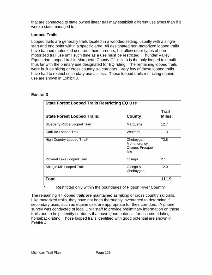
Michigan Trail Plan Page 125
that are connected to state owned linear trail may establish different use types than if it were a state managed trail.
Looped Trails
Looped trails are generally trails located in a wooded setting, usually with a single start and end point within a specific area. All designated non-motorized looped trails have banned motorized use from their corridors, but allow other types of non-motorized trail use until such time as a use must be restricted. Thunder Valley Equestrian Looped trail in Marquette County (11 miles) is the only looped trail built thus far with the primary use designated for EQ riding. The remaining looped trails were built as hiking or cross country ski corridors. Very few of these looped trails have had to restrict secondary use access. Those looped trails restricting equine use are shown in Exhibit 3.
EXHIBIT 3
State Forest Looped Trails Restricting EQ Use
State Forest Looped Trails: County Trail Miles:
Blueberry Ridge Looped Trail Marquette 12.7
Cadillac Looped Trail Wexford 11.3
High Country Looped Ttrail* Cheboygan, Montmorency, Otsego, Presque Isle
73.8
Pickerel Lake Looped Trail Otsego 2.1
Shingle Mill Looped Trail Otsego & Cheboygan
12.0
Total 111.9
* Restricted only within the boundaries of Pigeon River Country
The remaining 47 looped trails are maintained as hiking or cross country ski trails. Like motorized trails, they have not been thoroughly inventoried to determine if secondary uses, such as equine use, are appropriate for their corridors. A phone survey was conducted of local DNR staff to provide preliminary information on these trails and to help identify corridors that have good potential for accommodating horseback riding. Those looped trails identified with good potential are shown in Exhibit 4.
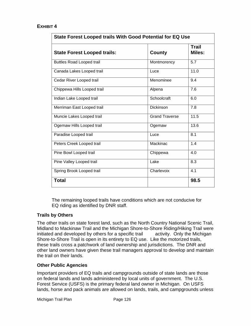
Michigan Trail Plan Page 126
EXHIBIT 4
State Forest Looped trails With Good Potential for EQ Use
State Forest Looped trails: County Trail Miles:
Buttles Road Looped trail Montmorency 5.7
Canada Lakes Looped trail Luce 11.0
Cedar River Looped trail Menominee 9.4
Chippewa Hills Looped trail Alpena 7.6
Indian Lake Looped trail Schoolcraft 6.0
Merriman East Looped trail Dickinson 7.8
Muncie Lakes Looped trail Grand Traverse 11.5
Ogemaw Hills Looped trail Ogemaw 13.6
Paradise Looped trail Luce 8.1
Peters Creek Looped trail Mackinac 1.4
Pine Bowl Looped trail Chippewa 4.0
Pine Valley Looped trail Lake 8.3
Spring Brook Looped trail Charlevoix 4.1
Total 98.5
The remaining looped trails have conditions which are not conducive for EQ riding as identified by DNR staff.
Trails by Others
The other trails on state forest land, such as the North Country National Scenic Trail, Midland to Mackinaw Trail and the Michigan Shore-to-Shore Riding/Hiking Trail were initiated and developed by others for a specific trail activity. Only the Michigan Shore-to-Shore Trail is open in its entirety to EQ use. Like the motorized trails, these trails cross a patchwork of land ownership and jurisdictions. The DNR and other land owners have given these trail managers approval to develop and maintain the trail on their lands.
Other Public Agencies
Important providers of EQ trails and campgrounds outside of state lands are those on federal lands and lands administered by local units of government. The U.S. Forest Service (USFS) is the primary federal land owner in Michigan. On USFS lands, horse and pack animals are allowed on lands, trails, and campgrounds unless
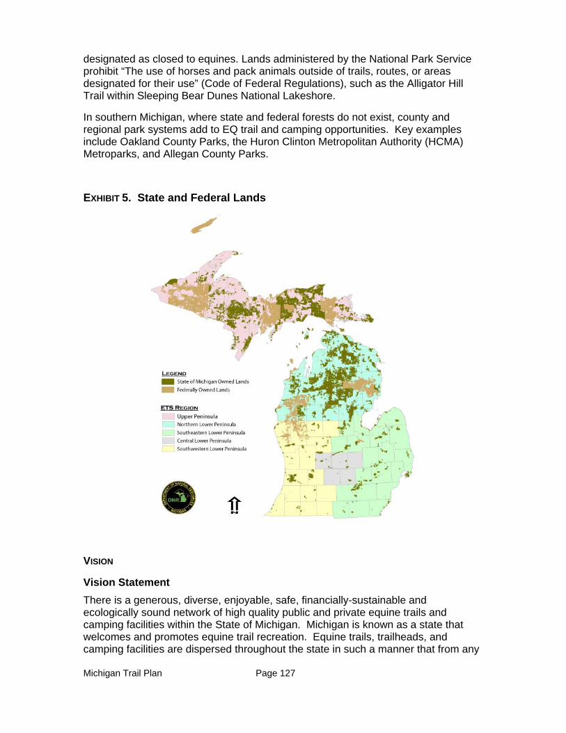
Michigan Trail Plan Page 127
designated as closed to equines. Lands administered by the National Park Service prohibit “The use of horses and pack animals outside of trails, routes, or areas designated for their use” (Code of Federal Regulations), such as the Alligator Hill Trail within Sleeping Bear Dunes National Lakeshore.
In southern Michigan, where state and federal forests do not exist, county and regional park systems add to EQ trail and camping opportunities. Key examples include Oakland County Parks, the Huron Clinton Metropolitan Authority (HCMA) Metroparks, and Allegan County Parks.
EXHIBIT 5. State and Federal Lands
VISION
Vision Statement
There is a generous, diverse, enjoyable, safe, financially-sustainable and ecologically sound network of high quality public and private equine trails and camping facilities within the State of Michigan. Michigan is known as a state that welcomes and promotes equine trail recreation. Equine trails, trailheads, and camping facilities are dispersed throughout the state in such a manner that from any
Michigan Trail Plan Page 128
point within the state, there will be day riding opportunities within a two-hour drive, overnight equestrian accommodations within a four-hour drive, and Signature Equestrian Centers within an 8-hour drive.
Expanded Vision Statement
In 2018, Michigan is known as “The Trail State” that welcomes the trail rider. Both Michiganders and tourists recognize and appreciate the reputation of Michigan with respect to trail riding and camping. This reputation is bolstered by the abundant and diverse choices of high quality trails, looped trails, trailhead staging areas, and equine campgrounds available to the equestrian on federal, state, county, and private lands.
The rider’s choice, and the planning of the ride, is facilitated by an interactive regional map, accessed through a single internet portal that accurately relates riding and camping opportunities and characteristics in each region. At each location, there are downloadable maps of trails that can be printed or put into global positioning devices. Riding associations are clearly identified on the internet portal site and they also provide Global Positioning System (GPS) data to load directly into handheld devices. There is also available for purchase a hardcopy book of 2018 maps and characteristics of Michigan equestrian trails and campgrounds.
The 2018 rider can select from enjoyable looped or point- to- point trails. Many of these trails and looped trails connect, so that it is possible to ride long distances. All trails and looped trails are clearly signed and are connected to high quality campgrounds and/or trailhead staging areas. In southern Michigan, the system of EQ trails utilizing state park and recreation area trails, rail-trails, and other connectors provides a unique riding experience with changing topography, scenic views, and access to local amenities, all of which are located in close proximity to the state’s most populous areas. One particularly popular trail system stretches from Jackson to Pontiac Lake Recreation Area, and plans are being implemented to provide a connecting trail that reaches from Jackson west to Lake Michigan along this same corridor. Communities along this popular set of trails, praise the system as a treasure significant to their community well-being.
Throughout the state, there are “trail towns” which connect directly to the trails that welcome and provide for the needs of equestrians. More and more trail towns are being self-identified each year, and it is easy for a community to assess what is needed to be attractive to the equestrian via internet materials specifically dedicated to “becoming a valued trail town”.
Equestrians are well informed about the guidelines and regulations that assure safe and ecologically sound experiences. All are informed about “Leave No Trace” camping and riding guidelines. The equestrian community is positively engaged in partnership with agencies, businesses, and other trail users to assure the ecological and financial sustainability of the state-wide trail network. Equestrians effectively self-police, so the need for law enforcement of various trail and campground regulations is quite minimal. There is a conflict resolution and mediation process administered by a partnership of the DNR and the newly created Michigan State University Mediation Center that is well used by various trail users, and that keeps disputes and conflict to a minimum.
Michigan Trail Plan Page 129
It is easy for the agencies to communicate with the trail riding community via internet (e.g. email, twitter, etc.) and because a single association represents the majority of the associations’ interests. This single association also provides considerable benefits to their members in the form of consultation, trail map books, GPS data, conflict resolution advice, and facilitation. This single association also stands ready to answer questions from new riders be they Michiganders or tourists, and offers youth incentive program, and seminars on pertinent trail riding topics.
There are clear processes developed for the nominating and selection of new trail and campground opportunities or addressing problems with existing facilities. Equestrians feel that they are a valued part of the process and decisions that guide the future of the equestrian trail system.
The vision for a quality equestrian system is based on the data gathered from focus group meetings, surveys, the ETS 2011 Recommendations Report and the USDA Forest Service (Hancock, et.al, 2007).
The ideal design components that define “high quality” trails, trailheads, campgrounds and a “Signature Equestrian Center” include the following:
Trails:
1. Will be easily accessible from trailheads or campgrounds and well-marked.
2. Signage will include trail maps, trail indicators and confidence markers.
3. Will consist of both linear and looped trails with the majority being looped trails between 10 and 30 miles in length for day rides, more for multi-day locations.
4. Will have watering sites along the trail corridor, ideally every 10 miles.
5. Surfaces will be firm without wet organics, slick rocky surfaces, or easily eroded soil types. Alignments will avoid steep hills and fall line construction that are difficult to maintain.
6. Trail tread shall be a minimum of two feet wide for single track trails, and a minimum of 10-feet wide for side-by-side and cart/carriage driving. Adequate turning radii on turns and curves will be provided for cart/carriage driving trails.
7. Shall be groomed to retain a 10 -foot overhead height clearance and an additional two feet either side of the trail tread for side clearance.
8. Paths shall traverse a variety of terrain and vegetation to enhance the riding experience.
Trailheads:
1. Adequate parking for at least 3 car-trailers that are a minimum of 28 feet wide and 55 feet long.
2. Access roads and parking spaces provide a minimum of 35’ turning radii for easy maneuvering of large rigs.
3. Are level, with well-maintained access road and parking surfaces that reduce the risk of equine injuries while in transit.
Michigan Trail Plan Page 130
4. An information kiosk that explains the rules, regulations, etiquette policies (i.e. where to dispose of manure), emergency contact information and a trail map.
5. Access to drinkable water.
6. Shall provide restrooms and mounting blocks.
7. Include shaded equine picket or corral areas.
8. Provide direct access to trails.
Campgrounds:
1. Have either an Information Station (un-staffed) or a Registration Office (staffed) to explain the registration process, site rules, regulations, and information about the trails.
2. Roads and campsites provide a minimum 35’ turning radii for easy maneuvering of large horse trailers and campers. Access road is well maintained to reduce risk of equine injuries while in transit.
3. Campsites are flat, level and have adequate clearance around camper and horse trailer to allow easy access and work space for equine care activities. Minimum length of campsite/trailer parking shall be 55 feet.
4. Adequate equine picket or corral areas that will accommodate the maximum number of equines allowed per campsite. Each campsite will have shade for equines when at rest.
5. Sanitary facilities meeting the minimum requirements for licensed campgrounds will be provided.
6. Each designated site will contain a fire ring and picnic table, and the campground will have one community fire circle.
7. A minimum of one manure bunker for every 10 sites shall be provided with adequate isolation from campsites.
8. Mounting blocks will be provided near all common areas, including restrooms and water supply locations.
9. The siting of campgrounds will avoid areas that contain plants toxic plants to horses.
Signature Equestrian Centers:
1. Contain at least 3 different choices of camping opportunities
a. Rustic
b. Semi-Modern c. Modern
2. Offer variable riding experiences for both the day rider and overnight guests.
a. Multiple loops providing a minimum total of 75 miles of trail of varying distances between 10-20 miles in length.
b. Range in difficulty with varying terrain and vegetative cover c. Provides varying widths for single file riding, side by side riding and
horse and cart driving.
Michigan Trail Plan Page 131
3. Offer variable picket and corral/stall containment areas for equines during overnight stays.
4. Offer enclosed corral riding area.
5. Provide wash racks for equine cooling and grooming.
6. Provide non-horse related recreation and entertainment on site and/or nearby.
EQUESTION’S CHARACTERISTICS, CONCERNS, AND PERCEIVED NEEDS
Statewide Opportunities
The statewide opportunities listed below are based on Focus Group meetings and an Equestrian Trail User Survey, all of which were conducted in August and September of 2012. A Focus Group meeting was held within each of the ETS Regions (Exhibit 6) and a total of 55 individuals representing various equine associations participated. The Equestrian Trail User Survey was distributed statewide electronically through user groups, and garnered 574 responses from individual horse riders. Summaries of the responses received from these efforts are found in the appendix.

Michigan Trail Plan Page 132
EXHIBIT 6. ETS REGIONS
Other surveys were referenced, including the ETS Trail Survey found in the ETS 2011 Recommendation Report, the DNR’s Trail Survey of all trail users conducted in August 2012, and other states’ research related to demand for EQ trails and campgrounds.
The following opportunities are based on data analysis of the surveys and focus group meetings cited above.
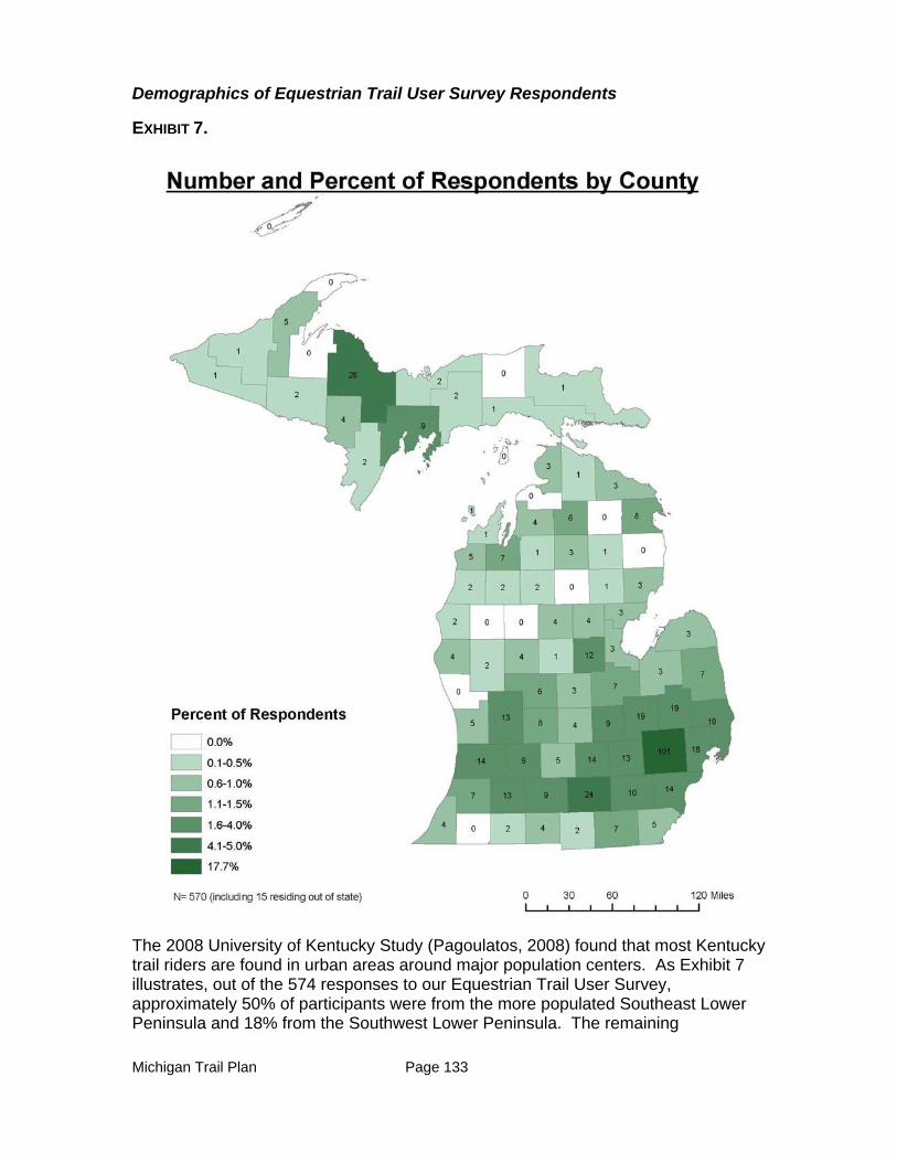
Michigan Trail Plan Page 133
Demographics of Equestrian Trail User Survey Respondents
EXHIBIT 7.
The 2008 University of Kentucky Study (Pagoulatos, 2008) found that most Kentucky trail riders are found in urban areas around major population centers. As Exhibit 7 illustrates, out of the 574 responses to our Equestrian Trail User Survey, approximately 50% of participants were from the more populated Southeast Lower Peninsula and 18% from the Southwest Lower Peninsula. The remaining
Michigan Trail Plan Page 134
respondents came from the Northern Lower Peninsula (19%), the Upper Peninsula (10%) and out of state (3%). These results correlate directly with population densities in the state.
According to the DNR’s 2012 Trail Survey, when a respondent’s EQ use increased it was mainly due to greater interest from friends and family. Most survey participants were over the age of 50 and were female.
Participation in the five focus group meetings held around the state did not match those of the state’s demographics. The focus groups with the greatest participation were those held in the Upper Peninsula and in the northern Lower Peninsula. These meetings were equally attended by both genders. Many of the attendees were representing their associations in these focus groups.
Priorities
When asked to make a choice, the majority of riders participating in either the focus groups or answering the Equestrian Trail User Survey would prefer to see the number of EQ trails and campground facilities offered in the state increase over improving existing EQ trails and campgrounds. However, many also had concrete ideas of improvements that would expand existing trail lengths, and achievable maintenance initiatives that would improve the existing system.
Location
An analysis of where riders live and where their primary riding location is (Exhibit 8) shows that Southeast Lower Peninsula riders travel the most extensively outside of their region to access riding opportunities. It also reflects that riders from other regions are not proportionately frequenting EQ facilities in the Southeast Lower Peninsula. Exhibit 8 shows that the favorite riding destination for respondents is in Northern Lower Peninsula region. This result was supported by information gathered at the Focus Group meetings as well. One possible explanation is that EQs ride either near their home (day use or multiday) or they travel north of Clare for a multi-day riding experience. In the 2011 ETS Survey, when asked if there were adequate amounts of accessible trails and equine facilities such as campgrounds near their homes, most indicated that there were not. Further research would need to be conducted to determine if this impression is accurate and, if so, how these riding choices should influence the type and location of future investments in EQ trails, trailheads, and campgrounds.
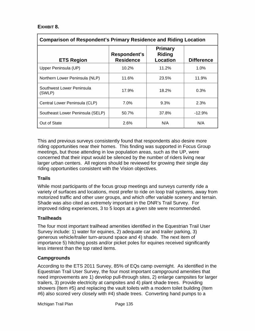
Michigan Trail Plan Page 135
EXHIBIT 8.
Comparison of Respondent’s Primary Residence and Riding Location
ETS Region Respondent’s
Residence
Primary Riding
Location Difference
Upper Peninsula (UP) 10.2% 11.2% 1.0%
Northern Lower Peninsula (NLP) 11.6% 23.5% 11.9%
Southwest Lower Peninsula (SWLP)
17.9% 18.2% 0.3%
Central Lower Peninsula (CLP) 7.0% 9.3% 2.3%
Southeast Lower Peninsula (SELP) 50.7% 37.8% -12.9%
Out of State 2.6% N/A N/A
This and previous surveys consistently found that respondents also desire more riding opportunities near their homes. This finding was supported in Focus Group meetings, but those attending in low population areas, such as the UP, were concerned that their input would be silenced by the number of riders living near larger urban centers. All regions should be reviewed for growing their single day riding opportunities consistent with the Vision objectives.
Trails
While most participants of the focus group meetings and surveys currently ride a variety of surfaces and locations, most prefer to ride on loop trail systems, away from motorized traffic and other user groups, and which offer variable scenery and terrain. Shade was also cited as extremely important in the DNR’s Trail Survey. For improved riding experiences, 3 to 5 loops at a given site were recommended.
Trailheads
The four most important trailhead amenities identified in the Equestrian Trail User Survey include: 1) water for equines, 2) adequate car and trailer parking, 3) generous vehicle/trailer turn-around space and 4) shade. The next item of importance 5) hitching posts and/or picket poles for equines received significantly less interest than the top rated items.
Campgrounds
According to the ETS 2011 Survey, 85% of EQs camp overnight. As identified in the Equestrian Trail User Survey, the four most important campground amenities that need improvements are 1) develop pull-through sites, 2) enlarge campsites for larger trailers, 3) provide electricity at campsites and 4) plant shade trees. Providing showers (Item #5) and replacing the vault toilets with a modern toilet building (Item #6) also scored very closely with #4) shade trees. Converting hand pumps to a
Michigan Trail Plan Page 136
pressurized water system was ranked 8 out of the 22 available options. This lower ranking was supported later when 74% of the respondent’s indicated that hand pumps were adequate to meet their watering needs within a campground. Many respondents indicated that they travel with their own water supply that will last them a couple of days within a campground.
Ride Duration and Length
The majority of participants of the focus group meetings and the online survey indicated that day riding was the most common EQ experience they participated in, traveling up to 2 hours to do so. Multi-day riding from one camping location was second with the majority of participants traveling up to 4 hours to get to their EQ facility location. Overall, the surveyed EQs will typically travel up to 4 hours for a quality riding experience.
For day rides, the majority of participants (44.9%) ride between five and 10 miles, although another 40% ride for 10 to 20 miles. For multi-day ride experiences, the majority of riders (51.5%) ride between 10 to 20 miles per day. When developing new trail experiences, this result indicates that daily trail lengths of five and 20 miles either in a looped system or between campgrounds/trailheads are ideal.
Communication
Analysis of survey data and focus group comments indicate a need for better communication between EQ organizations and the DNR. The top three opportunities for improvements in communication include:
1. A statewide map, guidebook and website listing (with maps) of all EQ trail facilities (campgrounds, trails, trailheads).
2. Better signage at all EQ facilities clearly identifying directions (including confidence markers), rules, regulations, emergency contacts, legal restrictions and maps.
3. More DNR communication and education with EQ partners. From past experience, it is assumed this communication would be about issues such as existing facilities and trails, expansion plans, maintenance issues, trail etiquette, trail conflicts, land management plans including timber harvest plans, and limitations because of land characteristics and/or funding sources.
Maintenance Fees
According to the DNR’s 2012 Trail Survey, 80% of EQs would support an annual maintenance fee for purposes of trail maintenance. The ETS 2011 Survey results also support this initiative; however, respondents in the Southeast Lower Peninsula showed the greatest opposition to fees. These results suggest an opportunity to investigate and implement these types of fundraising mechanisms in support of EQ trails.
Southeast Lower Peninsula Opportunities
While EQs in the Southeast Lower Peninsula take advantage of riding opportunities in other parts of the state, the focus group participants (8 total) preferred to stay closer to home when riding. When compared to the rest of the state, riders from this
Michigan Trail Plan Page 137
area prefer day rides that are on looped trails. This result could be a reflection of the greater number of looped trail riding and camping opportunities offered to the riders in this region. It should also be noted that only a few participants from other focus group indicated a desire to travel to the Southeast Lower Peninsula for their riding opportunities.
Survey data defining desired trail lengths and demographic information for this area indicate a need to increase EQ trail connection opportunities in this region. Specifically, connector trails are desired between state recreation areas. The top three locations for riding in this region are Proud Lake State Recreation Area, Highland State Recreation Area and Waterloo/Pinckney State Recreation Area.
Central Lower Peninsula Opportunities
Central Lower Peninsula focus group EQs (6 total) mainly ride at Ionia State Recreation Area (located in the Southwestern Lower Peninsula region) and Sleepy Hollow State Park. When compared with the rest of the state, riders from this area are more likely to travel for multi-day rides. Many riders, from this region, have an interest in traveling to the Northern Lower Peninsula for a “quality” trail riding and camping experience. This focus group population desires: more trails within the region, improved trail signage, more trails in Sleepy Hollow State Park including connection of Sleepy Hollow State Park trails to Clinton-Ionia-Shiawassee Trail, and on the Clinton-Ionia-Shiawassee Trail development linkages where EQ use is currently not allowed.
Southwest Lower Peninsula Opportunities
While focus group EQs (7 total) in the Southwest Lower Peninsula currently ride primarily at Yankee Springs State Recreation Area, Hungerford Lake Federal Recreation Area, and Silver Creek (Allegan State Game Area), many prefer to travel to the Northern Lower Peninsula for multi-day riding experiences. These riders shared the desire for more trails and campgrounds in their region. Users in this region specifically identified campgrounds with larger sites and longer trail lengths than what is currently being offered. Focus group participants mentioned the desire for a more modern, better designed campground, as well as the addition of a children’s trail that circles the campground, and connector trails between existing loop trails.
Northern Lower Peninsula Opportunities
Current use in this region by focus group participants (19 total) primarily occurs at Pigeon River Country State Forest and the Michigan Shore to Shore Hiking and Riding Trail. EQs from this region shared many of the same trends in the statewide opportunities listed above. The primary desire of participants in the Northern Lower Peninsula focus group was centered around the expansion of EQ opportunities (state and federal) in the region and, specifically, to open more riding and camping opportunities within or near the Pigeon River Country State Forest and west of I-75. More well-marked looped trails associated with existing and new campgrounds were also requested. Other desires included a modern campground facility to attract riders from other regions (Wisconsin and the Lower Peninsula) and more trails in state forests. In the survey, multi-day riding trended higher than single-day riding.
Michigan Trail Plan Page 138
Northern Lower Peninsula EQs also desired better communication with the DNR in developing new facilities.
Upper Peninsula Opportunities
The primary concern of the focus group EQs in the Upper Peninsula (15 total) was to increase the riding opportunities in their region. Although many of the focus group participants indicated that the majority of their riding and cart/carriage driving occurs within the region, there was a strong desire for more state-owned EQ trail and camping opportunities here. Also worth noting, when compared to the rest of the state, riders in this area preferred to ride on forest roads. Various sites for repurposing closed or under-developed campgrounds and trails were identified. Among these sites, the federal Pine Marten Trail has popular EQ camping use that provides a good opportunity for expansion. Specific trail improvements desired included longer trails as well as wider trails to accommodate for side-by-side riding and cart/carriage driving. Riders here also supported obtaining riding information from the internet as opposed to other forms of communication.
OPPORTUNITIES FOR BUSINESS RELATED DEVELOPMENT
Business related development can complement and enhance the trail user’s quality of experience. Examples include (but are not limited to):
Tack shops accessible to EQ trails and campgrounds
Large animal veterinary services
Horse boarding (e.g. B&B for horses) and grooming
Stables with horses to rent, and related services
Rider boarding (e.g. B&B, motel/hotel, campgrounds for people)
Restaurants, ice cream shops, fuel, grocery, and general merchandise (This is also supported by data in the DNR’s Trail Survey)
Outfitters or guides to support large group rides, etc.
Entertainment and recreation opportunities in which EQs may participate when not riding (e.g. movies, golf, fishing, swimming, etc.)
Many such examples already exist, and current business owners and entrepreneurs just need to be made aware of the EQ market that they can serve. Others represent untapped possibilities.
OPPORTUNITIES FOR PRIVATE SECTOR INVOLVEMENT
The opportunities for private sector involvement in support of EQ trail and camping use in Michigan are many. Examples include:
Festivals and events that promote EQ trail riding
Support for EQ groups and associations
Marketing and branding
Transient boarding facilities near trails
Fundraising
Endowment programs (identified in 2011 ETS Recommendation Report)
Michigan Trail Plan Page 139
Partnerships with land trusts (e.g. Equestrian Land Conservation Resource and Trust)
Snowmobile trail private easement agreements (potential for EQ use) Support and promotion of ‘Trail Towns’
Trail Towns
There are many communities that are interested in becoming trail town. Trail towns are those that are a destination on a distance trail and which cater to various trail users. There is existing information about how a community can successfully become a “trail town” - see the information available on the Land Information Access Association (LIAA.org). The LIAA has assisted the “Up North Trails Initiative” in Michigan by providing information for trail towns in a 22-county effort that included cooperation with the Northeast and the Northwest Michigan Council of Governments as well as stakeholders. The LIAA produced a trail town manual, see http://www.liaa.org/downloads/north_central_state_trail_town_manual.pdf. Additionally, Pennsylvania has a trail town initiative and their manual of guidance can be found in the appendix to the LIAA North Central State Trail Town Manual.
EQs can help identify the best way for a trail town to take advantage of those local business community opportunities. For example, many trail riders have their own live-in trailers, but would welcome a business that provided corrals, showers, and meals. Or, an EQ friendly, traditional Bed and Breakfast along a distance trail might be a welcome choice for trail riders. Identification of these local businesses, with good maps to locate them, could occur through an interactive map and inventory of trail towns catering to EQs. The Discover US Heritage Route 23 website www.us23hertigeroute.org of interactive maps and inventory is a model for how to connect a variety of business types, campgrounds, recreational experiences, and towns for a visitor’s recreational trip planning.
BARRIERS (THREATS)
Barriers to EQ activities in the state of Michigan were identified from the online survey and focus group meetings. These barriers act as road blocks for proposed EQ improvements in Michigan.
Land Restrictions
There are many sources of funds that are used to purchase state lands for public purposes. Three primary sources of funding that include restrictions with respect to EQ related recreation on the acquired lands are (1) Pittman Robertson Wildlife Restoration Funds (PR), (2) Dingell Johnson Sport Fish Restoration Fund (DJ) and License Fee Acquired Lands (LF).
PR/DJ Grant Acquired and Managed Lands
DNR lands which are PR/DJ acquired and/or managed are distributed in a checker board pattern across the state. Many of these areas are desirable to a variety of recreation users. Horseback riding is not prohibited on PR/DJ land. However, when it does occur, the intensity and frequency cannot interfere with the primary purpose of hunting and fishing. For example, PR/DJ funds cannot be used for enforcement of use restrictions or other non-PR/DJ purposes on PR/DJ lands. Should the US Fish

Michigan Trail Plan Page 140
and Wildlife Service determine that the state is not adequately managing the frequency and intensity of EQ use on these lands; and if a satisfactory resolution is not achieved, future PR/DJ funding is jeopardized. Since these funds have been significant—$23.5 million in 2012, careful management of EQ (and other non-hunting and non-fishing activities) has been a state concern.
License Fee Acquired and Managed Lands
Some DNR lands were acquired and/or are managed through hunting and fishing license fees. A provision of the PR (1937) and DJ (1950) Acts is that states must assent to only use state license fees for fish and wildlife services. Michigan passed Assent in 1939. The state acceptance for these provisions is found in Section 324.40501 of the Natural Resources and Environmental Protection Act 451 where it states “…funds accruing to this state from license fees paid for by hunters shall not be used for any purpose other than game and fish activities under the administration of the DNR.” If this restriction is strictly interpreted then horseback riding may be restricted on these lands.
Collaboration
EQ organizations identified that their working relationship with the DNR varies between management areas. Consistent policies and procedures are needed to help ease these working relationships. Many users have expressed an interest in developing more trails and are frustrated with the lack of response from the DNR when approached.
User Fees and Approvals
Confusing fee rates, the method of achieving approvals, and the time required for approval for use of EQ trail camps were identified as problems that needed resolution. Respondents expressed frustration over the dissimilarity of state camping fees compared to the amenities they offer. The lack of clear registration directions at un-staffed campgrounds was also cited as a problem.
Travel Information
A lack of information on trail locations (maps) and trail conditions are barriers to attracting trail riders to Michigan. Additionally, 40% of EQs polled in the DNR’s 2012 Trail Survey indicate that the state has poor promotion of available EQ experiences.
Coordination
A lack of coordination and cooperation between EQ riding associations and groups was identified as a barrier to garnering approval, funding, and implementation of more EQ trails and campgrounds in Michigan. (Note: The list of EQ associations and groups found in the Appendix totals nearly 80 individual groups statewide)
Education
Focus group comments and survey data show that the lack of information on how to use EQ trails causes barriers to a quality riding experience. Cited were the lack of trail signage, maps, information regarding rules and regulations, fee collecting procedures, and proper trail etiquette including “leave no trace” practices. Trail users cite that poor trail etiquette results in user conflicts.
Michigan Trail Plan Page 141
Perceived Threats
Gas Prices/Distance From Home: Threats identified for the EQ community include high gas prices, which threaten to prevent EQs from traveling greater distances to their favorite destinations.
Out-of-State Facilities: Another potential threat to the EQ economy in Michigan is riders traveling out-of-state for their EQ experiences. Many EQs in the Upper Peninsula identified going to Wisconsin for their quality riding experience while others in the Southwestern Lower Peninsula cited trips to Indiana, Wisconsin, Kentucky, or Tennessee for their quality riding experience.
Use Conflicts: EQs identified that opportunities have diminished for them statewide due to real and perceived conflicts with other users. Regionally, user conflicts were higher in the Upper Peninsula and the Northern Lower Peninsula with ORV users when compared to state-wide average. Conflicts with hunters in Southeast Lower Peninsula were higher than the state-wide average.
Some recreation area users in the Southern Lower Peninsula also had conflicts with mountain bikers, though the survey indicated state-wide that EQs had few interactions with other user groups while trail riding. Focus group meeting feedback perceived that other user groups did not want equines using the trails, and that trail closures could result. These perceived concerns include the inability to hear EQ users when they approach, the unpredictability of equines, manure left behind, and erosion of trail surfacing from equine use.
EQs expressed that other users do not know how to behave around equines and that there are safety concerns with mixing non-EQs with EQs in the same campground.
Equity of Use: Minimal campground facilities have been created to serve EQ users. While EQs can only camp in these given facilities, other users are not necessarily restricted from equine campgrounds. In addition, the lack of EQ trails forces EQs to ride on trails not designed or built for them. The EQ user is asking for parity of facilities in line with other user types.
Maintenance and Construction: Although many EQ facilities are constructed and maintained by EQ associations and groups, larger projects may be difficult for these groups to accomplish. Examples of these activities may include access road improvements, severe erosion control and major tree clearing. While groups are willing to perform some of these tasks, these activities require special equipment, certifications, and/or licenses.
OVERALL GOALS (NEXT 5 YEARS)
Complete comprehensive EQ trails and facilities inventory
Improve and expand DNR EQ trails and facilities
Promote EQ trails and facilities to users and businesses
Michigan Trail Plan Page 142
Collaborate with partners and governmental agencies to improve communications, expand riding opportunities and to maintain trails and facilities
Identify and pursue stable funding to develop and maintain equine facilities
Develop a conflict resolution process
RECOMMENDATIONS
In partnership with the ETS and equine riding community, the following goals and recommendations were developed. The first three recommendations under each goal are the highest priority.
Goal #1 - Complete comprehensive EQ Trails and Facilities Inventory and Analysis
1. As part of the internet portal development, provide an online trails database that includes comprehensive geospatial data, descriptions, and pictures of public EQ trails, trailheads and campgrounds including those “permissive use” trails that are identified as suitable for EQ use. [Primary lead: DNR]
2. Once the inventory is adequate, provide a gap analysis of where infrastructure needs must be pursued to achieve Vision goals (e.g. abandoned county roads, utility corridors or user created trails). [Primary lead: DNR]
3. Prioritize potential projects by geographic area in consideration of state lands and existing state facilities, and where trails and facilities can be enhanced and/or expanded for equine use. [Primary lead: DNR]
4. Develop guidelines and assess the suitability of ORV trails, snowmobile trails (undeveloped) rail-trails, and existing looped trails for EQ use. [Primary lead: DNR]
5. Inventory and publish EQ trails and facilities on other public lands such as county parks, municipalities and federal lands. [Primary lead: DNR]
Goal #2 - Improve and Expand DNR EQ Trails and Facilities
1. Open opportunities in our state forest, parks and game areas to allow horseback riding. In those state lands were equine trail use has been curtailed due to management constraints (e.g. land funding restrictions) identify similar equine trail opportunities in close proximity to the closed trails, campgrounds, or trailheads.
2. Expand riding trails at non-linear state parks and recreation areas with EQ facilities so riders have access to a minimum of 10 miles of trail. Look for opportunities to configure trails so multiple loops are provided including connections to other trails nearby (including neighboring states). [Primary lead: DNR]
3. Investigate opportunities to re-purpose existing or reopen closed U.P. state forest campgrounds for EQ use, with the objective of designating 2 or more EQ campgrounds with access to 20 miles of loop trails and/or

Michigan Trail Plan Page 143
connectivity to existing equine trails in the Upper Peninsula. [Primary lead: DNR]
4. Investigate and provide designated trail riding opportunities in several dispersed locations in the Upper Peninsula that will provide a minimum of 10 miles of well-marked trails and basic trailhead amenities for day rides. [Primary lead: EQs]
5. Develop and implement the process to identify and connect existing EQ trails with particular attention to Southeast Michigan state parks and recreation areas. [Primary lead: EQs]
6. Using existing or new state forest EQ campgrounds north of Clare and south of the Mackinaw Bridge, identify opportunities for loop riding trail development that would provide a minimum of 20 total miles of riding opportunities per campground. [Primary lead: DNR]
7. Identify opportunities for designation of EQ trails in State Game Areas. [Primary lead: DNR]
8. Conduct a demand analysis to determine the need for a Signature Equestrian Park(s). [Primary lead: ETS/MSTAC]
9. Based on positive demand analysis results, identify potential locations for Signature Equestrian Parks and provide pros and cons for each. [Primary lead: DNR]
10. Develop uniform sign guidance covering design, content and location information for use on EQ trails, trailheads, and campgrounds. Partner with Friends Groups to place and maintain signs where needed. [Primary lead: DNR]
11. Develop an implementation plan for trails and facilities recommendations that includes quarterly reporting on implementation progress (Primary lead: ETS/DNR).
Goal #3 - Promote EQ Trails and Facilities to Users and Businesses
1. Collaborate with Pure Michigan, riding associations and others on the development of innovative promotional platforms that will draw new users, e.g. the development of awards/patches for riding certain areas of the state, or volunteering for maintaining certain amounts of trail corridors. [Primary lead: ETS]
2. As part of the internet portal development, provide detailed EQ information that includes location and trail maps garnered from the inventory, rules and procedures regulating use, trail etiquette and Leave No Trace policies that can be conveyed to users on a variety of platforms. [Primary lead: DNR]
3. Work with the Land Information Access Association, using Michigan’s “Up North Initiative” as a model to provide guidance on trail towns catering to EQs. [Primary lead: ETS/MSTAC]
Goal #4 - Collaborate with Partners and Governmental Agencies to Improve Communications, Expand Riding Opportunities and Maintain Trails and Facilities
Michigan Trail Plan Page 144
1. Inform equine riders of DNR’s trail proposal process. This information would allow EQ users the ability to assist in the identification and development of connecting EQ trails on private and public land. [Primary lead: DNR]
2. Partner with the U.S. Forest Service, other states, local governments and other public entities to provide trails and campgrounds that are identified as needed in the gap analysis. [Primary lead: DNR]
3. Investigate opportunities to partner with others in the design, construction, and operation of a Signature Equestrian Park. Develop through collaborative partnership(s) a feasibility assessment, development plan, business plan, and marketing plan. [Primary lead: DNR]
4. Inform the public on how they can effectively participate in the DNR’s land management planning processes. [Primary lead: DNR]
5. Collaborate with riding associations to facilitate opportunities so the equine community can learn how to initiate friends associations, perform trail maintenance activities, and achieve certification for chain saw operations. [Primary lead: EQs]
Goal #5 - Identify and Pursue Stable Funding to Develop and Maintain Equine Facilities
1. Encourage the Michigan Natural Resources Trust Fund Board to reinstate the $500,000 limit for development grants and to meet the Governor’s objective to make Michigan the “Trail State”, to place emphasis on trail related projects. [Primary lead: MSTAC]
2. Pursue reclassification of equine use as an approved alternative mode of transportation as defined by DOT/FHWA to qualify for bicycle-pedestrian federal funding. [Primary lead: ETS]
3. Investigate and make recommendation on other funding sources that have been implemented in other states, including, but not limited to; bridle tags and special license plates. [Primary lead: ETS]
4. Work with riding associations to promote purchase of the Recreation Passport to their members and others to provide stable funding for the development and maintenance of recreation facilities. [Primary lead: EQs]
5. Initiation of diversity in the campground fee structure would provide the means for development of expanded amenities, user pays for services received. [Primary lead: DNR]
Goal #6 - Develop a Conflict Resolution Process
1. Promote the establishment of an overall Friend’s Group for each State Park, Recreation Area, Forest, or Game Area which would consist of a representative from each user group and which can serve as the first step in resolving conflicts at a local level. [Primary lead: ETS]
2. Develop a group of qualified Michigan mediators/facilitators who will receive education in the laws and regulations which affect DNR’s administration of lands under its stewardship. [Primary lead: MSTAC]

Michigan Trail Plan Page 145
3. Develop a process for referrals to mediate/facilitate and resolve recurring conflicts between user groups utilizing those qualified Michigan mediators/facilitators who have received training in the laws and regulations related to DNR land administration. Costs of mediation/facilitation to be borne by the user groups involved in the conflict. [Primary lead: MSTAC]
4. Promote utilization of MSTAC as a forum for directing and facilitating conflict resolution at the regional or state organizational level. [Primary lead: MSTAC]
PLAN REVIEW AND UPDATE
The Equestrian Chapter of the Statewide Trail Network Plan has been developed to be a dynamic instrument, designed to provide information and guidance for EQ trail users and public land managers over time. To assure the relevance of this plan, it will follow a 5-year review and update cycle.
Michigan Trail Plan Page 146
EQ ASSOCIATIONS Contact List (State Parks and Recreation Areas) NAME CONTACT PERSON CONTACT
• Brighton Trail Riders Association Russ Spicer [email protected]
• Horse Friends of Fort Custer Nancy Simmonds [email protected]
• Highland Trail Riders Association Jaqui McAtee [email protected]
• Highland Equestrian Conservancy Sharon Greene [email protected]
• Ionia Horse Trail Association Bob Walker [email protected]
• Fort Custer Horse Friends Association N/A [email protected]
• Friends of the Kal‐Haven Trail Rich Bowser [email protected]
• Friends of Lakelands Trail Jim Fackert [email protected]
• Maybury State Park Trail Riders Debby Brown [email protected]
• Maybury Trail Riders Association Nancy [email protected]
• Ortonville Recreation Equestrian Association Steve Keim [email protected]
• Pinckney Trail Riders Association Sue Armstrong [email protected]
• Pontiac Lake Horseman’s Association Susie Sulla [email protected]
• Proud Lake Trail Riders Association Dee Pasquantonio [email protected]
• Sleepy Hollow Trail Riders Association Marsha Putnam [email protected]
• Waterloo Horseman’s Association Chad Simpson [email protected]
• Yankee Springs Trail Riders Association Ronald Walker [email protected]
December, 2012 (Riding Associations) NAME CONTACT PERSON CONTACT
• Addison Oaks Trail Riders Libby Dwyer [email protected]
• All Around Riders Club Devora Davis [email protected]
• Allegan County Pleasure Riders Vicki Cassidy [email protected]
• Alpena (MI) Horsemen's Club Bonnie Cornelius [email protected]
• Back Country Horsemen Marieta Davis [email protected]
• Back Country Horsemen, Pigeon River & Beyond Norm Seppi [email protected]
• Bay Winds Pony Club Ricki Babcock Nadji [email protected]
Michigan Trail Plan Page 147
• Big Bay Pony Club Susan Roll [email protected]
• Birchwood Pony Club Anne Zaharias [email protected]
• Cedar Ridge Pony Club Jennifer MacLeod [email protected]
• Elba Equestrian Complex (Genesee County) Amy M McMillan [email protected]
• Elk Hill Trail Riders Charlotte Prochazka [email protected]
• Everett A. Cummings Center (Genesee County) Nancy A Edwards [email protected]
• 4‐H Karen Waite [email protected]
• Grand River Pony Club Marc McKinley [email protected]
• Great Lakes Distance Riding Association N/A [email protected]
• Great Lakes Region Pony Club Stacey Urbin [email protected]
• Friends of the Allegan County Equine Trails System (FACETS)
Vicki Cassidy [email protected]
• Friends of Gladwin Chuck Fanslow [email protected]
• Friends of Gladwin Chuck Fanslow [email protected]
• Friends of Jordan Valley Kevin Rider [email protected]
• Friends of the Macomb Orchard Trail Neil Kocsis [email protected]
• Friends of the Musketawa Trail Ed Holovka [email protected]
December, 2012 FRIENDS ORGANIZATIONS Name Contact Person Contact
• Friends of the Polly Ann Trail Cathy Brakefield [email protected]
• Friends of Rockport Carol Dodge‐ [email protected]
Grochowski [email protected]
• Headwaters Trails Sue Julian [email protected]
• Highland Hills Pony Club Alysia Apley [email protected]
• Huron River Trail Riders Cathy Branum [email protected]
• Huron Valley Pony Club Rebecca Sadler [email protected]
• Kalamazoo Valley II Pony Club Karen Barsuhn [email protected]
• Kensington Trail Riders Association Bill Terian [email protected]
• Lake Superior Pony Club Kelly Valensky [email protected]
• Little Traverse Bay Pony Club Kecia Freed kecia@twin‐valley.net
• Macatawa Pony Club Bart Shumaker [email protected]
• Mackinac Horsemen's Association Leanne Brodeur [email protected]
• Marquette County Horse Club Andi Goriesky [email protected]
Michigan Trail Plan Page 148
• Mason County Saddle Club Tracy Gillies [email protected]
• Metamora Hunt Club Michelle Mortier [email protected]
• Metamora Hunt II Pony Club Pamela Koskinen [email protected]
• Michigan Black Horsemen’s Association N/A http://mblackha.webs.com/
• Michigan Competitive Mounted Orienteering Alison Bennett [email protected]
• Michigan Equine Partnership (MEP) Larry Julian [email protected]
• Michigan Fox Trotter Association N/A michfoxtrotters.com
• Michigan Harness Horseman's Association LeeAnn Franks mhha@mhha‐online.com
• Michigan Horse Drawn Vehicle Association N/A http://www.mhdva.org/
• Michigan State University Horsemen’s Association N/A www.msu.edu/~msuha/contact
• MHC Trail Riders Committee Therese Kline [email protected]
• Michigan Interscholastic Horsemanship Association Michael Yanz [email protected]
• Michigan Rocky Mountain Horse Club Brenda Ricksger [email protected]
• Michigan State 4‐H State Trail Riders Bill Nelson [email protected]
• Michigan Trail Riders Christine Rayner [email protected]
• Northeastern Michigan Association of Horse Clubs N/A [email protected]
• Northwest Michigan Draft Horse and Mule Association Susan Zenker [email protected]
• Oakland County Pony Club Cindy McLaughlan 248‐887‐4915
• Oakland County 4‐H Youth Program Heather McAtee [email protected]
• Oakland Equestrian Coalition Merle Richmond [email protected]
• Orchard Hill Pony Club Mirta Soler [email protected]
• Raisin River Riders Nancy Harvey [email protected]
• Ranch Horse Association of Michigan N/A www.miranchhorse.com
• Rose Lake Pony Club Julie Millies‐Lucke [email protected]
• Rusty Spur Trails Riders Association N/A [email protected]
• Shiawassee Trail Riders Connie Frey [email protected]
• Shore to Shore Trail Riders LTD Larry Wahl [email protected]
• Southern Links Trail Friends Group Dale Fuller 810.793.2453
• Tri County Horse Association Vicki Sible [email protected]
• UP Trail Riders Norm Seppi [email protected]
• Upper Midwest Endurance and Competitive Rides Association (UMECRA)
Theresa Meyer [email protected]
• Walk Away Trail Riders Elaine Winkel [email protected]
Michigan Trail Plan Page 149
APPENDIX 7
ACKNOWLEDGEMENTS:
MICHIGAN COMPREHENSIVE TRAIL PLAN RESEARCHED AND WRITTEN BY:
Donna Stine, Jim Radabaugh, Richard Kennedy, Anna Marie Bauer, Paige Perry, Todd Neiss, Paul Curtis, Ron Yesney, Paul Yauk, Rob Katona, Mary Dettloff, Steve Kubisiak, Erin Treanore, Suzan Limburg, Molly Black, and Anastasia Endres-Bercher.
Report layout and design by: Jami Selden
CHAPTER 2 - MOTORIZED TRAIL SYSTEM
ORV: Rob Katona
Snowmobile: William Manson, Richard Kennedy
CHAPTER 3 - NON-MOTORIZED TRAIL SYSTEM
LOOPED TRAILS:
Todd Neiss, Paige Perry, Emily Meyerson, Erin Treanor, Suzy Limburg, Molly Black
EQUESTRIAN TRAILS:
The Equestrian Chapter of the Statewide Trails Network Plan is the outcome of a collaborative effort involving the Equine Trailways Subcommittee (ETS), the Department of Natural Resources (DNR), and the National Park Service – Rivers, Trails & Conservation Assistance Program (NPS-RTCA). A key contributor to the recommendations found herein are the EQs themselves, who provided valuable input in an EQ survey and at the five EQ focus group meetings, held around the state.
DNR/ETS “EQUESTRIAN PLANNING TEAM” includes:
DNR Land Administration
‐ Paul N. Curtis, Chair Parks and Recreation (PRD)
‐ Matt Lincoln PRD
‐ Brittany Blankenship PRD
‐ James Radabaugh PRD (Forest Recreation)
‐ Annamarie Bauer PRD (Forest Recreation)
‐ Brenda Curtis PRD (Forest Recreation)
‐ Earl Flegler Wildlife Division (WD)
Michigan Trail Plan Page 150
‐ Georgia Peterson Forest Resources Division (FRD)
ETS
‐ Sandra Batie (ETS Chair) Central Southern Lower Peninsula
‐ Jan Herrick Eastern Southern Lower Peninsula
‐ Sarah Nicholls Tourism and Marketing (Statewide)
NPS – RTCA
‐ Barbara Nelson-Jameson Michigan Program Director
‐ Mary Hanson Outdoor Recreation Planner
In the conduct of data gathering, fact checking, surveys, and focus groups, we had the assistance of the full ETS membership, which in addition to those on the Planning Team above, included: Joni Gleason (UP), Dick Kleinhart (NLP), and Mike Foote (SWLP). Other DNR staff also assisted the Planning Team, including: Dustin Corr (PRD), Valerie Frawley (Wildlife Division), and Jennifer Olson (Wildlife Division).
LINEAR TRAILS:
Nancy Krupiarz, Anna Marie Bauer and Paul Yauk
CHAPTER 4 - WATER TRAILS
Mary Bohling, Harry Burkholder, and Donna Stine

Michigan Trail Plan Page 151
APPENDIX 8
References
Abildso, Christiaan G., Sam Zizzi, Laurie C. Abildso, Jenessa C. Steele, and Paul M. Gordon. 2007. “Built Environment and Psychosocial Factors Associated with Trail Proximity and Use.” American Journal of Health Behavior 2007; 31(4):374–83. Available: http://www.eteamz.com/TweetsieHistoricTrail Association/files/04JulAug0407Abildso.pdf. [Accessed 9/25/12.]
Adelaja, S., Y. Hailu, T. Borowy, and J. Sharma. 2010. “How Important Are Parks and Trails to Michigan’s Economic Recovery?” A Land Policy Institute State of the State Bulletin. East Lansing, Mich.: Michigan State University, Land Policy Institute. Available: www.ippsr.msu.edu/SOSS/ Publications/ParksTrails.pdf. [Accessed 9/25/12.]
Alexander, L. 1995. “The Effect of Greenways on Property Values and Public Safety.” Colorado State Trails Program, Denver, CO.
Barthlow, K. and R. Moore, 1998. “The Economic Impacts and Uses of Long-Distance Trails.” United States Department of Interior, The National Park Service, Washington, D.C. Available at http://ntl/bts.gov/12000/12200/12275.pdf.
Commute by Bicycle: Michigan Ranks 31, Lansing State Journal, Oct 3, 2012.
2012. “DNR Recreation Provider Survey.” Internal, unpublished document provided to Public Sector Consultants by the MDNR (6/1/12).
Michigan Trails and Greenways Alliance (MTGA), National Park Service: Rivers, Trails, and Conservation Assistance (NPS-RTCA), and Michigan Recreation and Park Association (MRPA). 2007. “Connecting Michigan: A Statewide Trailways Vision and Action Plan.” Lansing, Mich.: Michigan Trails and Greenway Alliance. Available: http://michigantrails.org/connectingmichigan/ connecting_michigan_plan.pdf [Accessed 9/25/12.]
Nelson, C., D. Synes, L. Wu, et al. 2010. Michigan Licensed ORV Use and Users – 2010. East Lansing, Mich.: Department of Community, Agriculture, Recreation and Resource Studies, Michigan State University, and Michigan Department of Natural Resources and Environment.
Nelson, Charles M., I-Chun Wu, Daniel J. Stynes, and Erin McCarty. March 30, 2010. Assessment of Snowmobiling in Michigan by Snowmobilers with Trail Permits, 2009. Prepared for the Michigan Department of Natural Resources and Environment. Available: www.michigan.gov/documents/dnr/SNOWMOBILE-RPT_322022_7.pdf. [Online, accessed 11/26 12.]
Outdoor Foundation, “Outdoor Recreation participation: Topline Report 2012,” Adult Participation, 2012, Available: http://www.outdoorfoundation.org/pdf/ResearchParticipation2010.pdf (accessed 11/26/12
Michigan Trail Plan Page 152
Outdoor Industry Association. 2012. “The Outdoor Recreation Economy.” Boulder, Co.: Outdoor Industry Association, with Southwick Associates Inc. Available: http://www.outdoorindustry.org/pdf/OIA_OutdoorRecEconomyReport2012.pdf (Access 11/26/12)
Pennsylvania Trail Towns Program. Available: http://www.trailtowns.org/Data/Sites/1/trail_town_user_survey_final_report.pdf [Accessed 11/26/12]
Public Sector Consultants, 2012. Michigan Outdoor Recreation Telephone Survey Summary of Finding, Prepared for the Michigan Department of Natural Resources
Public Sector Consultants, 2012. “2013-2018 Michigan Comprehensive Outdoor Recreation.” Michigan Department of Natural Resources, Lansing MI.
Stynes, D., J. Lynch, and C. Nelson. February 1998. State and Regional Impacts of Snowmobiling in Michigan. East Lansing, Mich.: Michigan State University, Department of Park, Recreation and Tourism Resources.
Sjoquist, G. 2003. “Economic Impact of Trails.” American Trails org. Available at http://www.americantrails.org/resources/economic/MNecon.html.
Stynes, Daniel. 2010. Economic Analysis of the 2009 Michigan Snowmobiler Survey: State and Regional Impacts of Snowmobiler Spending. N. p.Tri-County Bicycle Association. 2012. 42nd Annual Dick Allen Lansing to Mackinaw BicycleTour. Available: www.dalmac.org.[Online, accessed 11/26/12.]
Wolf, Christopher, John Kaneene, Steve Miller, Mary Rossano, Marty Saffell, and Christine Skelly. 2006. “Economic Impact of the Michigan Equine Industry, 2006”. Summary of a Research Report. Department of Agricultural Economics, Michigan State University, East Lansing, Michigan. http://www.horsescountinmichigan.com/Portals/0/docs/Economic%20Impact%20of%20Michigan%20Equine%20Industry%202006.pdf
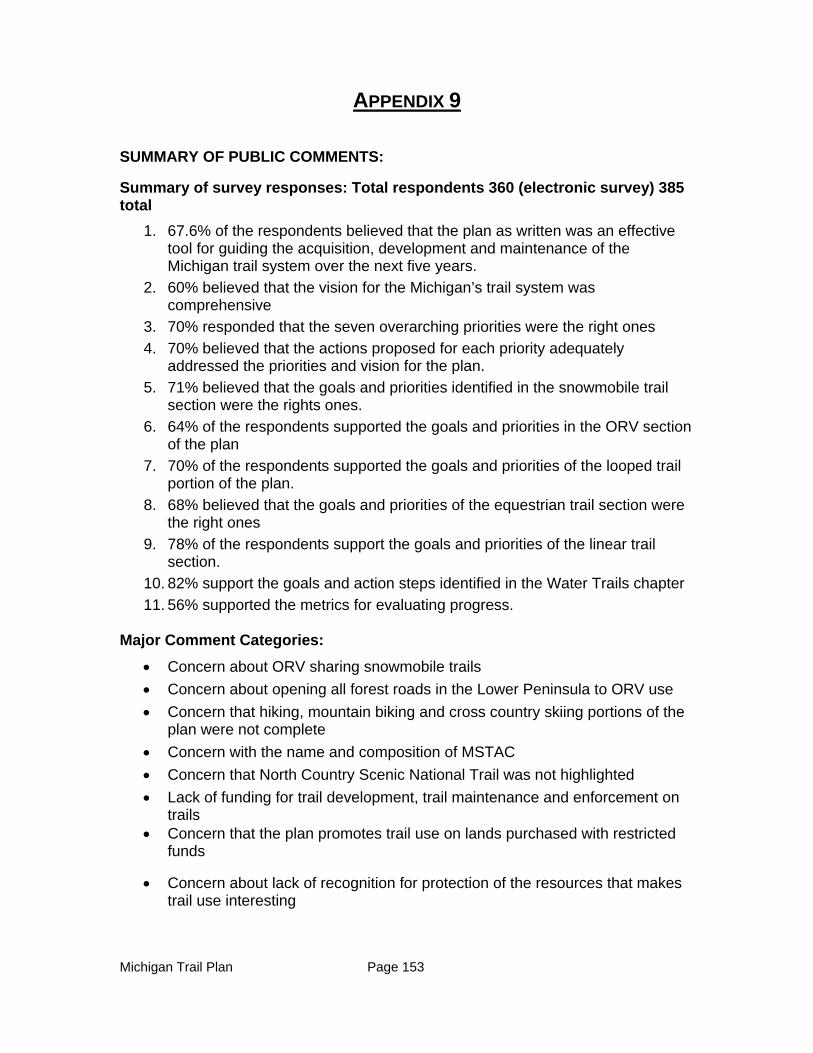
Michigan Trail Plan Page 153
APPENDIX 9
SUMMARY OF PUBLIC COMMENTS:
Summary of survey responses: Total respondents 360 (electronic survey) 385 total
1. 67.6% of the respondents believed that the plan as written was an effective tool for guiding the acquisition, development and maintenance of the Michigan trail system over the next five years.
2. 60% believed that the vision for the Michigan’s trail system was comprehensive
3. 70% responded that the seven overarching priorities were the right ones
4. 70% believed that the actions proposed for each priority adequately addressed the priorities and vision for the plan.
5. 71% believed that the goals and priorities identified in the snowmobile trail section were the rights ones.
6. 64% of the respondents supported the goals and priorities in the ORV section of the plan
7. 70% of the respondents supported the goals and priorities of the looped trail portion of the plan.
8. 68% believed that the goals and priorities of the equestrian trail section were the right ones
9. 78% of the respondents support the goals and priorities of the linear trail section.
10. 82% support the goals and action steps identified in the Water Trails chapter
11. 56% supported the metrics for evaluating progress.
Major Comment Categories:
Concern about ORV sharing snowmobile trails
Concern about opening all forest roads in the Lower Peninsula to ORV use
Concern that hiking, mountain biking and cross country skiing portions of the plan were not complete
Concern with the name and composition of MSTAC
Concern that North Country Scenic National Trail was not highlighted
Lack of funding for trail development, trail maintenance and enforcement on trails
Concern that the plan promotes trail use on lands purchased with restricted funds
Concern about lack of recognition for protection of the resources that makes trail use interesting
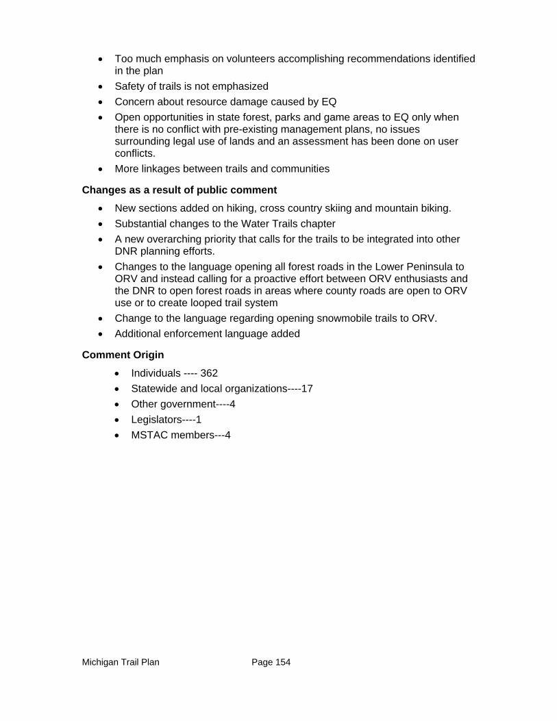
Michigan Trail Plan Page 154
Too much emphasis on volunteers accomplishing recommendations identified in the plan
Safety of trails is not emphasized
Concern about resource damage caused by EQ
Open opportunities in state forest, parks and game areas to EQ only when there is no conflict with pre-existing management plans, no issues surrounding legal use of lands and an assessment has been done on user conflicts.
More linkages between trails and communities
Changes as a result of public comment
New sections added on hiking, cross country skiing and mountain biking.
Substantial changes to the Water Trails chapter
A new overarching priority that calls for the trails to be integrated into other DNR planning efforts.
Changes to the language opening all forest roads in the Lower Peninsula to ORV and instead calling for a proactive effort between ORV enthusiasts and the DNR to open forest roads in areas where county roads are open to ORV use or to create looped trail system
Change to the language regarding opening snowmobile trails to ORV.
Additional enforcement language added
Comment Origin
Individuals ---- 362
Statewide and local organizations----17
Other government----4
Legislators----1
MSTAC members---4