Embed Size (px)
Citation preview

OSNA 2012 Website Report
Photo: Boro Becks Project
MIDDLESBROUGH OPEN SPACES NEEDS ASSESSMENT 2012
1

CONTENTS
Open Spaces Needs Assessment 2012 Page
Overview 3
Open Space Typologies Map 4 Sample Green Flag Quality Score Sheet 5 Sample Green Flag Value Score Sheet 6 Amenity and Natural Green Spaces Distance Threshold Plan 7
Parks and Public Gardens Distance Threshold Plan 8
Play Areas Distance Threshold Plan 9 Youth Activities Areas Distance Threshold Plan 10 Quality and Value Assessments Results (Bar Charts) 11 Open Spaces Quality Scores (Town Map) 12 Open Spaces Value Scores (Town Map) 13
Summary of Assessment Findings 14
Appendix 1 OSNA Quantity Targets and Survey Results Appendix 2 OSNA Quality and Value Scores
2

1. Middlesbrough’s Open Spaces Needs Assessment 2012 Overview
1.1 The Open Spaces Needs Assessment (OSNA) 2012 looked at Middlesbrough’s significant, publically accessible open spaces under various land use catagories or ‘typologies’ and assessed the sites for quantity, quality and strategic value of provision. In addition, some special land uses were noted that are private and not publically accessible to provide a complete picture of open space provision. Open Space provision covers a range of different land uses such as parks, local conservation sites, allotments, play areas and green spaces and the distribution map is shown on this report’s page 4. The assessment checked that Middlesbrough would have enough open space provision for the future. Middlesbrough’s first assessment was carried out in 2005. The 2005 assessment was used as a base line for an update audit of open spaces in 2012 and underpinned the Green Spaces Public Spaces Strategy 2007- 12.
1.2 All green space quantity targets were reviewed and updated in line with current best practice and legislation. Specific targets and quantity results are outlined in Appendix 1 of this report for each land catagory. Certain types of special land use were noted as part of Middlesbrough’s open space provision, irrespective of size, whether publically accessible or on privately owned land, but were not included in the quantity calculations of other types of specific or general green space provision. These special unquantified land catagories, for example, applied to those local wildlife sites which were not designated Local Nature Reserves, sports and recreation centres, civic spaces and memorial gardens and certain types of specialist sports provision.
1.3 There have been many changes over the last 7 years, including substantial
open space improvements, so there was a need to re score the quality and strategic value of individual sites. The nationally recognised Green Flag quality standards were used wherever appropriate to assess quality. The value of the sites to the town was assessed in terms of contribution to overall green infrastructure, appearance and bio diversity. The score sheets used are shown on pages 5 and 6.
1.3 Officers revisited and scored the quality and community value of 160
individual sites during the summer of 2012 and specific scores for each site can be seen in Appendix 2. In addition, the quantity and distribution across Middlesbrough of each type of significant open space, e.g. allotments, play area, parks, was mapped. These maps are shown on pages 7 -10. The accumulated data collected indicated the over and under provision of each typology and enabled comparisons with the 2005 survey as outlined in Appendix 1. This information has been fed into the planning process and will underpin future open space and physical infrastructure decisions for the town. A summary of the findings including plans and charts are included in this report on pages 11 – 16.
3

2. Open Spaces Typologies Map
4

3. Sample Green Flag Quality Score
Sheet
5

4. Sample Green Flag Value Score Sheet
6
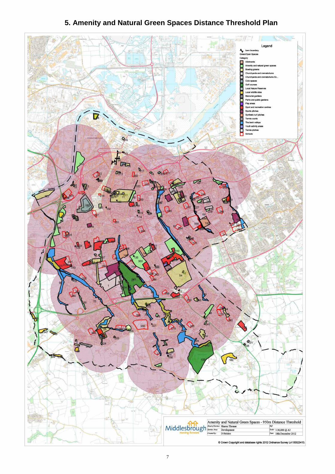
5. Amenity and Natural Green Spaces Distance Threshold Plan
7

6. Parks and Public Gardens Distance Threshold Plan
8

7. Play Areas Distance Threshold Plan
9

8. Youth Activities Areas Distance Threshold Plan
10

9. Quality and Value Assessments Results (Bar
Charts)
10. Open Spaces Quality Scores
OSNA - Quality Assessment
0%10%20%30%40%50%60%70%80%90%
100%
Allotm
ents
Amenity
& natur
al gree
n spac
es
Churchy
ards and
crem
atoriu
ms
Civic s
paces
** Mem
orial
garde
ns
Parks a
nd pub
lic ga
rdens
Play ar
eas
* Sport
s pitc
h surr
ounds
The be
ck va
lleys
Youth
activ
ity ar
eas
Typology
% S
core
20052012
OSNA - Value Assessment
0%10%20%30%40%50%60%70%80%90%
100%
Allotm
ents
Amenity
& natur
al gree
n spac
es
Churchy
ards and
crem
atoriu
ms
Civic s
paces
** Mem
orial
garde
ns
Parks a
nd pub
lic ga
rdens
Play ar
eas
* Sport
s pitc
h surr
ounds
The be
ck va
lleys
Youth
activ
ity ar
eas
Typology
% S
core
20052012
11

10. Open Spaces Quality Scores (Town Map)
12

11. Open Spaces Value Scores (Town Map)
13

12. Summary of Assessment Findings
1.1 There was an improvement in quality since 2005 across all the different typologies scored except for sports pitch surroundings. The Playing Pitch Strategy 2009 is currently being reviewed and is due for completion in 2013. This detailed study will look at the demand, supply and quality of playing pitches in detail.
1.2 The assessment showed a decrease in the number of sports and synthetic
pitches however the 2005 survey included school sports provision. The 2012 survey excluded school site facilities, as community use may not be guaranteed. The reviewed 2013 Playing Pitch Strategy will include the assessment of the existing quantity and quality of provision.
1.3 There was an improvement in the value scores across all of the scored
typologies in comparison to the 2005 survey except for Civic Spaces that had a slight reduction. The 2012 survey included areas previously not scored for example, Captain Cooks Square and North Ormesby Market Place, which might explain this difference.
1.4 The Parks and Green Spaces sites awarded a Green Flag in 2012 were
scored as exceptional for quality and value.
1.5 Areas for improvement in quality included Newham Beck and Middlebeck as well as the land adjacent to the A19 between Maldon Road and Mandale Road.
1.6 The South West Iron Masters site was the only site that scored poor for
value however this site is planned to be largely developed in the future with investment in adjacent green infrastructure.
1.7 In terms of square meterage, Middlesbrough has more than the
recommended provision for Parks and Public Gardens.
1.8 Middlesbrough Council has moved toward fewer but larger, better-equipped and maintained play area sites since 2005 as a result of the Play England approved Middlesbrough Child’s Play strategy 2006 - 2011. £1.5 million of external funding over the last 7 years has enabled the refurbishment of existing play areas as well as the creation of new play areas.
1.9 There is good coverage across the town for play areas however there is a
shortfall in Acklam and Linthorpe.
14

1.10 Middlesbrough has more than the recommended provision for Youth Activity
Areas in terms of square meterage. The distance thresholds however indicate a shortage of Youth Activity areas particularly to the south east of the town as well as parts of Linthorpe and Acklam.
1.11 There are 19.7 allotments per 1000 households this is 4.7 allotments per
1000 households more than the 2012 target. The move toward smaller more manageable plots has helped to increase the number available as well as the creation of new sites in the south of the town particularly.
1.12 Those areas not within the walking distance threshold for Amenity and
Natural Green Spaces are within the walking distance threshold for Parks and Public Gardens. The exception to this is a small part of Ormesby and Netherfields close to the borough boundary.
15