Embed Size (px)
Citation preview

MILK RIVER INTEGRATED WATERSHED MANAGEMENT PLAN
July 2, 2014

ACKNOWLEDGEMENTS Milk River IWMP Team Brian Hills, Alberta Environment and Sustainable Resource Development Greg Ottway, Alberta Tourism, Parks and Recreation Jennifer Nitschelm, Alberta Agriculture and Rural Development Joan Hughson, MRWCC Director Ken Miller, Miller Seeds Ltd., MRWCC Director Mary Lupwayi, MRWCC Program Coordinator Ross Ford, County of Warner, MRWCC Director Sam Wirzba, Alberta Environment and Sustainable Resource Development Sandi Riemersma, Palliser Environmental Services Ltd. Terrence Lazarus, Alberta Environment and Sustainable Resource Development Tim Romanow, MRWCC Executive Director Will Lindeman, MRWCC Director Technical Support Aaron Domes, Alberta Tourism, Parks and Recreation Brandy Downey, Alberta Environment and Sustainable Resource Development Brad Downey, Alberta Conservation Association Darrin Britton, Alberta Environment and Sustainable Resource Development Dennis Spackman, Alberta Tourism, Parks and Recreation Francois Blouin, MULTISAR – Prairie Conservation Forum Jeff Gutsell, Alberta Environment and Sustainable Resource Development Lynn Fitzpatrick, Alberta Environment and Sustainable Resource Development Terry Clayton, Alberta Environment and Sustainable Resource Development Simon Brookes, Alberta Environment and Sustainable Resource Development Wendell Koning, Alberta Environment and Sustainable Resource Development Map Support Blair Watke, Alberta Environment and Sustainable Resource Development River Access Sub-Committee Darcy Wills, Milk River Watershed Council Canada Greg Ottway, Alberta Tourism, Parks and Recreation Ken Brown, Milk River Raft Tours Mary Lupwayi, Milk River Watershed Council Canada Tim Romanow, Milk River Watershed Council Canada Will Lindeman, Milk River Watershed Council Canada Oil and Gas Industry Sub-Committee Allan Goosney, Crescent Point Darlene Sakires, Canadian Natural Resources Ltd. Jon Boyle, Rangeland Conservation Services Ltd. Kevin Redden, Medicine Hat Gas Company Rhonda Busch, Alberta Energy Regulator Trevor Murray, DeeThree Exploration Ltd.

Milk River Watershed Council Canada
Milk River Integrated Watershed Management Plan Page ii
ENDORSEMENTS AND/OR SUPPORT

Milk River Watershed Council Canada
Milk River Integrated Watershed Management Plan Page iii
TABLE OF CONTENTS
ACKNOWLEDGEMENTS .................................................................................................................................. i ENDORSEMENTS AND/OR SUPPORT ............................................................................................................ ii PREAMBLE ................................................................................................................................................... vi 1.0 INTRODUCTION ..................................................................................................................................... 1 2.0 PURPOSE AND INTENT .......................................................................................................................... 2 3.0 STATEMENT OF ISSUES .......................................................................................................................... 2 4.0 OBJECTIVES ............................................................................................................................................ 4 5.0 PLANNING AREA .................................................................................................................................... 5
5.1 MILK RIVER WATERSHED ..................................................................................................... 5 5.2 REACH DELINEATION ............................................................................................................ 6
6.0 ROLES AND RESPONSIBILITIES ............................................................................................................... 9 7.0 PUBLIC ENGAGEMENT AND FEEDBACK PROCESS ............................................................................... 11 8.0 RECOMMENDATIONS AND IMPLEMENTATION STRATEGY ................................................................. 13
8.1 SURFACE WATER QUANTITY ..................................................................................................... 13 8.1.1 Outcome and Goals ......................................................................................................... 13 8.1.2 Recommendations .......................................................................................................... 13 8.1.3 Implementation Strategy ................................................................................................ 16
8.2 SURFACE WATER QUALITY OBJECTIVES .................................................................................... 18 8.2.1 Outcomes and Goals ....................................................................................................... 18 8.2.2 Targets ............................................................................................................................. 18 8.2.3 Recommendations .......................................................................................................... 22 8.2.4 Implementation Strategy ................................................................................................ 23
8.3 GROUNDWATER ........................................................................................................................ 24 8.3.1 Outcomes and Goals ....................................................................................................... 24 8.3.2 Targets and Thresholds ................................................................................................... 24 8.3.3 Recommendations .......................................................................................................... 25 8.3.4 Implementation Strategy ................................................................................................ 31
8.4 RIPARIAN AREAS AND WETLANDS ............................................................................................ 36 8.4.1 Outcomes and Goals ....................................................................................................... 36 8.4.2 Targets and Thresholds ................................................................................................... 36 8.4.3 Recommendations .......................................................................................................... 37 8.4.4 Implementation Strategy ................................................................................................ 46

Milk River Watershed Council Canada
Milk River Integrated Watershed Management Plan Page iv
8.5 BIODIVERSITY ............................................................................................................................ 48 8.5.1 Outcomes and Goals ....................................................................................................... 48 8.5.2 Targets and Thresholds ................................................................................................... 49 8.5.3 Biodiversity Indicators ..................................................................................................... 49 8.5.4 Recommendations .......................................................................................................... 51 8.5.5 Implementation Strategy ................................................................................................ 54
8.6 LANDUSE ................................................................................................................................... 57
8.6.1 AGRICULTURAL ACTIVITY .......................................................................................................... 57
8.6.1.1 Outcomes and Goals .................................................................................................... 57 8.6.1.2 Targets and Thresholds ................................................................................................ 57 8.6.1.3 Recommendations ....................................................................................................... 58 8.6.1.4 Implementation Strategy ............................................................................................. 61
8.6.2 INDUSTRIAL AND COMMERCIAL ACTIVITY (OIL AND GAS) ....................................................... 63 8.6.2.1 Outcomes and Goals .................................................................................................... 63 8.6.2.2 Targets and Thresholds ................................................................................................ 63 8.6.2.3 Recommendations ....................................................................................................... 63 8.6.2.4 Implementation Strategy ............................................................................................. 69
8.6.3 TOURISM, RECREATION AND ACCESS ....................................................................................... 74 8.6.3.1 Outcomes and Goals .................................................................................................... 74 8.6.3.2 Targets and Thresholds ................................................................................................ 74 8.6.3.3 Recommendations ....................................................................................................... 74 8.6.3.4 Implementation Strategy .............................................................................................. 77 9.0 ECONOMY ........................................................................................................................................... 80
9.1 Outcomes and Goal ............................................................................................................ 80 9.2 Targets and Thresholds ...................................................................................................... 80 9.3 Recommendations ............................................................................................................. 80 9.4 Implementation Strategy ................................................................................................... 82
10.0 SCHEDULE .......................................................................................................................................... 85 11.0 LIST OF ACRONYMS ........................................................................................................................... 85 12.0 BIBLIOGRAPHY................................................................................................................................... 86
12.1 Literature Cited ......................................................................................................................... 86 12.2 Map Information ....................................................................................................................... 89

Milk River Watershed Council Canada
Milk River Integrated Watershed Management Plan Page v
Appendix A. Summary of MRWCC goals, IWMP objectives and environmental outcomes for the Milk River watershed. ......................................................................................................................................... 90 Appendix B. Evaluation of flows required to safely navigate the Milk River by canoe, raft or tube as identified through scheduled canoe trips by local operators. .................................................................... 92 Appendix C. History of Milk River Water Supply Investigations. ............................................................... 93 Appendix D. Groundwater maps. ............................................................................................................... 96 Appendix E. Milk River watershed surficial geology map. ......................................................................... 99 Appendix F. Recommended restricted activity dates and setback distances by level of disturbance (ESRD 2011). ................................................................................................................................................ 100 Appendix G. Summary of objectives and action recommendations for listed indicator wildlife species taken from Minister approved national Recovery Plans, ASRD-FWD approved Management Plans, and existing government planning documents. .............................................................................................. 101 Appendix H. Overview of range health and assessment and “good standing”. ...................................... 105 Appendix I. Enhanced Approval Process recommendations. The recommendations apply a minimum disturbance development philosophy. ..................................................................................................... 106

Milk River Watershed Council Canada
Milk River Integrated Watershed Management Plan Page vi
PREAMBLE
The Milk River Integrated Watershed Management Plan (Plan) was completed in May 2014 with the understanding that the Plan will be reviewed annually and updated every three years as new information is acquired and to reflect changing circumstances. Readers are encouraged to consult the Milk River Transboundary State of the Watershed Report (2013) for additional background information and maps pertaining to the watershed and its resources that are discussed throughout this Plan. Recommendations are put forward in this Plan for consideration by resource managers and watershed ‘users’, including landowners, residents, industry, recreational users, non-profit organizations, municipalities and provincial government agencies, so that watershed conditions (particularly environmental functions and valued ecosystem components) may be maintained and/or improved as a legacy for future generations. Plan recommendations are intended as suggestions that will help to achieve desired community outcomes related to surface water supply, water quality, groundwater, riparian areas and wetlands, biodiversity, land use and the economy. These outcomes were determined through community and stakeholder meetings early in the planning process. Resource managers and watershed users should be aware that the provisions in this plan are not binding on any person or entity. The Plan is not intended to be prescriptive; rather the Plan offers guidance to consider so that the desired goals and outcomes for the watershed may be achieved. These goals were developed in collaboration with community members and stakeholders and thereby reflect their ideals, values and concerns. Support or endorsement of this Plan means that resource managers and watershed users will endeavor to implement the various action recommendations as they are able and as is necessary to achieve goals to the best of their ability. The Plan was created with the expectation that recommendations will be voluntarily adopted by users, residents, leaseholders and landowners. The Plan should not infringe on private property rights.
The Milk River watershed is fortunate to contain large contiguous tracts of native grassland, a large variety of upland species and unique fish populations that tend to be at the northern extent of their ecological range. High levels of biodiversity are, in part, a product of the high percentage of Public Land that is found in the watershed and the stewardship actions that are undertaken by landowners and leaseholders. While biodiversity is highly valued in the watershed, it should not be maintained at the expense of basin resident’s ability to pursue their livelihood or to maintain economically viable farm and ranch operations; nor should it result in the erosion of private property rights. The cost of maintaining biodiversity (i.e., the retention of native flora and fauna) on private lands repeatedly surfaced in discussions. A number of landowners acknowledged their willingness to partner with governments and organizations to receive incentives and compensation for adopting land management regimes that favour wildlife while engaged in crop and livestock production. Maintaining biodiversity should not threaten or undermine the economic viability of agricultural production. Historically, the management of agricultural resources focused on improvements in livestock and crop productivity and in securing financial returns sufficient to maintain economically viable operations. While producers are inclined to achieve desired environmental outcomes identified

Milk River Watershed Council Canada
Milk River Integrated Watershed Management Plan Page vii
in this plan, they have expressed concern that doing so may impinge on economic viability of farm operations - current profit margins may be threatened in an already unstable economic region. The goal within this Plan is to balance the social, economic and environmental outcomes desired by the community in the watershed.
It needs to be emphasized that landowners and leaseholders within the Milk River watershed ask that this Plan be implemented in a way that respects property rights and personal capital investments. Currently, property owners have minimal ability to control activity (e.g., resource extraction, linear disturbance for power/energy infrastructure) on deeded lands. Compensation to landowners may not exist or is generally not adequate to recover the full losses experienced by private landowners when land disturbance or industrial activity takes place. With regard to maintaining biodiversity, current government policies and regulations do not encourage cooperation with landowners, rather landowners are penalized when species at risk are discovered on their property. Adequate compensation must be provided when recommended management practices for species at risk move beyond what can reasonably be accommodated by the agricultural industry.

Milk River Watershed Council Canada
Milk River Integrated Watershed Management Plan Page 1
1.0 INTRODUCTION The Milk River Watershed Council Canada (MRWCC) is a multi-stakeholder, not-for-profit organization operating in the Milk River watershed following their appointment as a designated Watershed Planning and Advisory Council (WPAC) in February 2006 by Alberta Environment and Sustainable Resource Development (ESRD). Membership includes representatives from municipal, provincial and federal governments, agriculture (irrigation, crop production and ranching sectors), environmental organizations, and the general public. The MRWCC is responsible for engaging stakeholders in watershed assessment and watershed management planning, considering existing land and resource management planning processes and decision-making authorities. To accomplish this, the MRWCC strives to provide stakeholders with timely, science-based watershed information that will support sustainable resource management. In 2005, a survey was used to identify valued watershed components in the Milk River region. Seven areas of interest were expressed through the surveys; these were: 1) water supply and management, 2) water quality, 3) conservation of wildlife and plant species diversity, 4) riparian protection, 5) an informed community, 6) good relationships with Saskatchewan and Montana, and 7) economic development. Goals, objectives and outcomes were identified for each of the seven valued watershed components by the MRWCC (Appendix A, Page 90). Since appointment, the MRWCC has been working to achieve their objectives. Studies were completed (the reports are available on the MRWCC website) to provide insight and fill data gaps for some of the valued watershed components, including:
Milk River Water Quality Program (2006-13)
Milk River Supplemental Water Supply Investigation (2007-08)
Economic Evaluation of Water Supply Options (2008)
Synoptic Groundwater Survey (2007; 2012)
Erosion and Sedimentation Study (2007-08)
Milk River Instream Flow Needs Study (2009-10)
Benthic Invertebrates Study (2008-2009)
Evaluation of Milk River Sediments (2009)
Streambank Stabilization Demo Project Conceptual Designs (2010)
Western Silvery Minnow Recovery Plan (approved; DFO/ASRD initiated, MRWCC Board supported)
St. Mary Sculpin Recovery Plan (DFO/ASRD Initiated, MRWCC Board supported)
Remote Metering Project (AENV/AARD Initiated, MRWCC Board supported)
Fecal Coliform Source Tracking Project (2012-2013)
In April 2008, the MRWCC released the first Milk River State of the Watershed (SOW) Report. This report summarizes the geography, geology and history of the watershed and comments on the current state of valued watershed resources including surface water and groundwater supply and quality, historical resources, fisheries and benthic invertebrates, riparian areas and wetlands, range health and wildlife. In 2013, the second edition of the Milk River Transboundary SOW Report was completed and was expanded to include the watershed area within Saskatchewan and Montana.

Milk River Watershed Council Canada
Milk River Integrated Watershed Management Plan Page 2
A number of recommendations were made in the Milk River SOW Report (2008) that provided direction for watershed management planning. These recommendations, in combination with the goals and objectives of the MRWCC, form the basis for moving forward with the development of the Milk River Integrated Watershed Management Plan (IWMP).
2.0 PURPOSE AND INTENT
The Milk River IWMP makes recommendations for adoption by decision making authorities, natural resource managers, basin users and basin residents regarding the management of land and water resources to achieve desired watershed outcomes and goals.
The Milk River IWMP links the issues of water quality, water quantity, riparian habitat and biodiversity with the watershed’s economic and social priorities. The plan provides management direction in the form of recommendations that will help guide the community’s activities for the benefit of future generations. The approach seeks to include balanced and representative public consultation. The Milk River IWMP will be presented as a guidance document and planning tool to all watershed stakeholders, including landowners, residents, a n d m u n i c i p a l , provincial and federal jurisdictions that have a mandate or management responsibility in the watershed.
Although considered a guidance document and planning tool, a recommendation will be put forward by the MRWCC, on behalf of all stakeholders, requesting the adoption of the IWMP by decision makers for consideration when reviewing proposals and development applications (approval and/or permits) that may impact land and water resources and their management in the Milk River watershed. All stakeholders participating in the development of this plan are encouraged to endorse and/or support the final Milk River IWMP and to implement it to the best of their ability.
The separate and future Approved Water Management Plan component of the IWMP, if approved by Cabinet, will give ESRD decision makers the ability to consider applications for water allocation transfers in the Alberta Milk River basin under the provisions of the Water Act. Decision makers will be required to consider any “Matters and Factors” that are included in the Approved Water Management Plan.
3.0 STATEMENT OF ISSUES
A survey was conducted during a public consultation process in 2005, prior to the formation of the MRWCC. The survey asked people to list the issues they believed were most pressing in the Milk River watershed. From the survey, a list of priorities was developed and goals and objectives were formed to address the main issues (Appendix A, Page 90). Since this initial input, the 2008 Milk River State of the Watershed Report was completed. A Technical Committee was struck to prioritize recommendations put forward in the SOW Report.
Purpose: The Milk River IWMP is a guidance document and planning tool and should be considered within broader regional and municipal planning initiatives and resource development strategies.

Milk River Watershed Council Canada
Milk River Integrated Watershed Management Plan Page 3
Similar issues and priorities were observed between the original survey in 2005 and the priority recommendations found in the SOW. The following is a list of priority areas that are ranked closely in terms of importance to stakeholders. In summary, the main concerns in the Milk River watershed are: Priority Concerns:
- Ability to secure a dependable water supply from a limited resource, - Limited economic development opportunities due, in part, to the limited, unsecure
supply of water, - Augmentation of natural flow in the Milk River by the St. Mary River diversion
(particularly the impacts associated with timing, duration and volume), and - Ability to maintain surface water and groundwater quality.
General Concerns
- Ability to maintain wildlife and biodiversity, - Potential loss/degradation of wetlands and riparian areas, and - Impact of various land uses (e.g. recreation, oil and gas, and agriculture) on watershed
resources. Issues that are of interest but outside of the scope of this IWMP are those related to:
- The review of the terms and conditions of the Boundary Waters Treaty 1909. Readers
using this document should be aware that a separate initiative is currently underway in which Alberta and Montana are working together to improve access to the shared water of the St. Mary and Milk rivers. The Montana-Alberta St. Mary and Milk Rivers Water Management Initiative aims to explore and evaluate options to improve access to the shared water of these two rivers.
In October 2013, the Government of Alberta released the draft South Saskatchewan Regional Plan (SSRP) that includes the Milk River watershed within the scope of its planning area. Concerns were raised by landowners, agricultural producers, leaseholders and municipalities across southern Alberta in response to the plan. The main concerns arising from the draft SSRP that were common within the Milk River watershed community and that warrant further discussion and direction within the Milk River IWMP are:
1. Local concern regarding how the provisions of the Alberta Land Stewardship Act could have detrimental impacts on landowner’s property rights.
2. The economic implications associated with preserving native grasslands and biodiversity (i.e., who pays), and
3. Property rights implications associated with preserving native grasslands and biodiversity.
The Milk River watershed is fortunate to contain large contiguous tracts of native grassland, a large variety of upland species and unique fish populations that tend to be at the northern extent of their ecological range within the Milk River watershed. High biodiversity is, in part, a product of the high percentage of Public Land maintained in the watershed and good stewardship on the part of landowners and leaseholders. While biodiversity is highly valued in

Milk River Watershed Council Canada
Milk River Integrated Watershed Management Plan Page 4
the watershed, it should not be managed at the expense of people’s ability to make a living within the watershed or without respect for individual property rights. While biodiversity is strongly valued within the Milk River community, the question of who will pay for biodiversity was brought forward a number of times throughout this planning process. While economic growth and prosperity are experienced in other parts of Alberta, communities in the Milk River watershed struggle to maintain and increase population and services (e.g., hospitals, schools). A balance between biodiversity and the well-being of the agricultural industry, and other sectors of the regional economy, is being sought.
4.0 OBJECTIVES1
The following nine objectives were developed to guide the development of the Milk River IWMP.
A. Water Supply and Allocation
Objective 1. As one component of the IWMP, develop an abbreviated Approved Water Management Plan (AWMP) under the provincial Water Act that:
a) Authorizes Alberta Environment and Sustainable Resource Development (ESRD) to consider applications for transfers of water allocations in the Milk River basin.
b) Specifies matters and factors that must be considered by ESRD when reviewing applications for transfers of water allocations.2
Objective 2. Recommend strategies that enhance the delivery and use of apportioned shares of water while maintaining environmental integrity in the Milk River watershed for both Alberta and Montana.
Objective 3. Recommend water conservation strategies that promote the efficient use of water for all sectors (i.e., municipal, industrial, irrigation, recreation).
B. Water Quality, Streambank and Riparian Protection
Objective 4. Recommend water quality objectives (WQOs) for four reaches of the Milk River (i.e., North Fork Milk River, Milk River mainstem (South Fork), Milk River Gravel-bed and Milk River Sand-bed).
Objective 5. Recommend minimum setback requirements for development from the Milk River and its tributaries and recommend appropriate management strategies to protect and/or enhance riparian and aquatic ecosystems.
1 Objectives 2-9 are not part of the Approved Water Management Plan, but rather this Integrated
Watershed Management Plan which does not require Cabinet approval. 2 In a subsequent phase of the planning process, amendments to the Approved Water Management Plan can
be made to include other matters that the Water Act directs in an Approved Water Management Plan. This might include recommendations for matters and factors that must be considered by Environment and Sustainable Resource Development decision makers when considering an application for an approval for construction or other activities that could negatively impact the aquatic ecosystem.

Milk River Watershed Council Canada
Milk River Integrated Watershed Management Plan Page 5
C. Groundwater
Objective 6. Recommend groundwater protection and conservation measures for vulnerable areas, including the Whisky Valley and Milk River aquifers.
D. Land Use
Objective 7. Recommend land use and development practices which are consistent with the objectives and resource management strategies for the Milk River watershed and its unique semi-arid environment.
E. Biodiversity
Objective 8. Recommend strategies to maintain biodiversity within the watershed.
F. Economy Objective 9. Recommend strategies to maintain and improve the economic condition within the Milk River watershed.
5.0 PLANNING AREA
5.1 MILK RIVER WATERSHED
The Milk River is the smallest of Alberta’s 7 major river basins, encompassing an area of 6,664 km2 (1,646,710 acres) (Figure 1). The Milk River is also the northern most tributary of the Missouri River. The watershed is a transboundary basin, spanning areas in the Provinces of Alberta and Saskatchewan and the State of Montana, U.S.A. The Milk River watershed boundary was updated in 2013 using the boundary layer created for the Montana-Alberta Water Management Initiative. This resulted in a slightly larger basin compared to the basin presented in the Milk River State of the Watershed Report (2008). As a result, the Village of Warner now lies on the boundary of the Milk River basin. Note that the Village of Warner is serviced with water from the Raymond Regional Water Line. The Town of Milk River and Village of Coutts are the other two major urban communities in the watershed. The Milk River is about 1,173 km long and flows through Montana and Alberta. The headwaters originate in northwestern Montana on the Blackfeet Reservation. The Milk River then enters Alberta, flows through the Town of Milk River, eastward and parallel with the southern Canadian border, prior to flowing back into Montana. The eastern tributaries (i.e., Lodge Creek, Battle Creek and Bare Creek) originate in the eastern part of the watershed and flow through Saskatchewan and south into Montana before joining the Milk River just east of Chinook, Montana. The Boundary Waters Treaty (Article VI) of 1909 was established to apportion the flows of the St. Mary and Milk Rivers between Canada and the United States and resolve water-sharing disputes. The details on how the water was to be shared were developed in the 1921
Milk River Watershed Council Canada
Milk River Integrated Watershed Management Plan Page 6
International Joint Commission (IJC) Order. Today, flows in the Milk River are augmented by water from the St. Mary River annually, typically during the period of April to October to meet the apportionment agreement. For the purpose of this IWMP, recommendations will apply to the area of the Milk River watershed that is located in Alberta, exclusively. However, some water management recommendations related to the timing, duration and volume of streamflows in the Milk River may be cooperatively implemented with Montana in the future.
5.2 REACH DELINEATION
Four reaches within the Milk River, Alberta, were used as boundaries to explore watershed resources in more detail and establish management objectives for applicable resources (i.e., water quality objectives, riparian management objectives). These reaches are the North Fork Milk River (Reach 1), Milk River Mainstem (South Fork) (Reach 2), the Gravel-bed Reach (Reach 3) and the Sand-bed Reach (Reach 4) (Figure 2). These reaches were previously identified in “The Biology and Status of Riparian Poplars in Alberta” (Bradley et al. 1991) and modified in the “Study of Sedimentation and Erosion on the Milk River” (AMEC 2008) to reflect changes in river gradient and bed material in addition to riparian and morphological changes (Figure 2).

Milk River Watershed Council Canada
Milk River Integrated Watershed Management Plan Page 7
Figure 1. Map of the transboundary Milk River watershed and its location in Alberta. Larger maps can be accessed in the Milk River Transboundary SOW Report (MRWCC 2013) or on the MRWCC’s website (www.milkriverwatershedcouncil.ca).

Milk River Watershed Council Canada
Milk River Integrated Watershed Management Plan Page 8
Figure 2. Map showing the four Milk River reaches defined in AMEC (2008) (ESRD 2013).

Milk River Watershed Council Canada
Milk River Integrated Watershed Management Plan Page 9
6.0 ROLES AND RESPONSIBILITIES
Landowners/Leaseholders Landowners and leaseholders manage the majority of land in the Milk River watershed for the purpose of agricultural production, mainly grazing, including Public Land (i.e., provincial Crown Land). In fact, of the 4,000 km2 of Public Land in the watershed, 3,837 km2 (96 %) are managed under grazing disposition. There are about 278 grazing dispositions issued by ESRD in the watershed, including 3 Cultivation Permits, 6 Farm Development Leases, 262 Grazing Leases, 4 Grazing Permits and 3 Provincial Grazing Reserves (L. Fitzpatrick, pers. comm). Grazing dispositions are also issued in parks and protected areas, including Writing-on-Stone Provincial Park, Cypress Hills Provincial Park and Kennedy Coulee Natural Area. These dispositions are administered by Alberta Tourism, Parks and Recreation. Management of Crown Lands occurs in cooperation between the disposition holder and the Provincial government. The leasee is a steward who manages a public asset. On deeded lands, agriculture is managed for best production generally achieved by applying good management of resources. Cultivated lands make up about 17% of the Milk River watershed area. Grain farms are found mainly in the central and western part of the watershed while ranching predominates in east. About 3,320 ha (8,200 acres) of land is available for irrigation; about 1,821 ha (4,500 acres) are actively irrigated. Standards for agricultural production are outlined in the Agricultural Operations Practices Act (AOPA), in municipal Acts, and in industry guidelines (e.g., Alberta Beef Producers, Canadian Cattle Commission). Landowners and leaseholders within the Milk River should be involved in development of future policy and guideline development. Traditionally, agriculture has been the foundation of economic development in the watershed and the priority land use within the watershed. Alberta Environment and Sustainable Resource Development Alberta Environment and Sustainable Resource Development (ESRD) has a legislated mandate for managing air quality, water resources, waste management, cumulative effects, provincial Crown (also called “public”) lands, the bed and shore of naturally occurring water bodies, and fish and wildlife resources in the Milk River watershed. ESRD’s mandate within the basin is significant because of the natural water bodies which are present, the sizeable public land base that exists and the large diversity of native plant and animal life that is found there. Public lands
Grazing leases are long-term authorizations to individuals, corporations or associations. Lease size ranges from an average of less than a section (640 acres) in central Alberta to almost three sections (1,920 acres) in the southern Alberta grasslands. In the Milk River watershed, lease sizes can be significantly larger. Grazing permits: Issued on an annual basis, often on land such as fragmented parcels and periodically wet areas (e.g., WOSPP). Provincial Grazing Reserves (PGRs) are community pastures located throughout the province that provide a significant amount of local, public grazing land. A head tax permit issued to the reserve association authorizes the grazing activity. Associations pay additional fees for rental of government buildings, corrals and maintenance of the pastures (ASRD 2003).

Milk River Watershed Council Canada
Milk River Integrated Watershed Management Plan Page 10
occupy approximately 60% of the basin (about 4,000 km2). These lands accommodate a variety of different surface and sub-surface land uses that provide wide ranging benefits for basin residents and Albertans. The oversight and management of provincial Crown assets (by provincial agencies) has been going on for several decades within the watershed. During this period of time, the Government of Alberta has adopted numerous policies, regulations, programs and administrative procedures to allocate and manage public land and natural resources in the basin. These are periodically reviewed and updated to reflect changing times and circumstance, shifting public values, advances in science and knowledge, or in response to particular resource management challenges that arise. Alberta Tourism, Parks and Recreation Alberta Tourism, Parks and Recreation – Parks Division manages parks and protected areas within the Milk River watershed (Figure 1). Most notable are Writing-on-Stone Provincial Park, Cypress Hills Provincial Park, the Kennedy Coulee Ecological Reserve, the Milk River Natural Area and the Onefour and Twin River Heritage Rangelands. Alberta Parks acts in accordance with the Provincial Parks Act, and the Wilderness Areas, Ecological Reserves, Natural Areas and Heritage Rangelands Act. In 2009, a 10-year Plan for Parks was endorsed, which commits Alberta Parks to achieving the following vision:
Alberta’s parks inspire people to discover, value, protect, and enjoy the natural world and the benefits it provides for current and future generations.
Within the Milk River watershed, Alberta Parks manages its land base to achieve a diverse variety of natural and cultural heritage objectives. Other key functions include promoting and facilitating appropriate visitor experiences, providing public safety and enforcement services on park lands, and operating and maintaining park facilities. Alberta Agriculture and Rural Development Alberta Agriculture and Rural Development (ARD) is a Water for Life Strategy partner and shares responsibility for goals and key actions related to safe, secure drinking water, healthy aquatic ecosystems, and water conservation. AARD provides technical and research support to WPAC committees throughout the province, including the MRWCC. In the Milk River basin, ARD is supporting research in water quality as related to fecal coliform source tracking. ARD is a member of the Montana-Alberta Joint Water Management Initiative, comprised of Alberta and Montana representatives, which is reviewing opportunities for improved water management by both jurisdictions on the St. Mary and Milk rivers. Agricultural practices in the Milk River watershed have a variety of connections to the department. ARD is responsible for the Agricultural Operations Practices Act (AOPA), legislation which sets manure management standards for Alberta operations. ARD promotes the development of improved irrigation water management technologies and practices to increase irrigation water use efficiency, and has been involved in real-time water use monitoring of private irrigators in the Milk River watershed. ARD delivers extension programs to assist producers to develop and implement plans to minimize impacts on the environment through the
Milk River Watershed Council Canada
Milk River Integrated Watershed Management Plan Page 11
Environmental Farm Plan, Alberta Environmentally Sustainable Agriculture and Growing Forward programs such as Stewardship Plans, On-Farm Energy Efficiency and On-Farm Water Management.
Alberta Energy Regulator The Alberta Energy Regulator is a regulatory body that was established in 2013 with a mandate to provide for the efficient, safe, orderly and environmentally responsible development of Alberta’s energy resources. The AER is responsible for regulating the life cycle of oil, oil sands, natural gas, and coal projects in Alberta from application and construction to production, abandonment, and reclamation.
The AER succeeds the Energy Resources Conservation Board and assumes the regulatory functions from the Ministry of Environment and Sustainable Resource Development that relate to public lands, water, and the environment. The AER is authorized to make decisions on applications for energy development, monitoring for compliance assurance, decommissioning of developments, and all other aspects of energy resource activities (activities that must have an approval under one of the six provincial energy statutes). This authority extends to authorizations pursuant to the Public Lands Act, the Environmental Protection and Enhancement Act and the Water Act that relate to energy resource activities.
Municipalities There are four rural municipalities (Cardston County, County of Warner, County of Forty Mile and Cypress County) and three urban municipalities (Town of Milk River, Village of Coutts and Village of Warner) within the Milk River watershed that have jurisdiction for land management within the watershed. Under Part 17 of the Municipal Government Act, municipalities have responsibilities in planning, regulating, subdividing and developing land in Alberta. They also have the authority to create planning and regulatory documents that prescribe how the land will be developed. These documents include statutory plans. They describe the planning policies and types of land uses permitted in the municipality and land use bylaws specifying development standards and regulations.
Agricultural Service Boards (ASBs), that form part of rural municipal government, are responsible for administering and developing programs to compliment Provincial legislation, including the Agricultural Service Board Act, the Weed Control Act, the Agricultural Pests Act and the Soil Conservation Act. It is generally the role of the Agricultural Fieldman to implement the work plan established by the ASB. Rural Extension Staff and/or Assistant Agricultural Fieldmen may also be employed to work directly with local producers and communities to provide technical assistance and to coordinate education opportunities (e.g., workshops, field tours) for land managers that promote environmental stewardship.
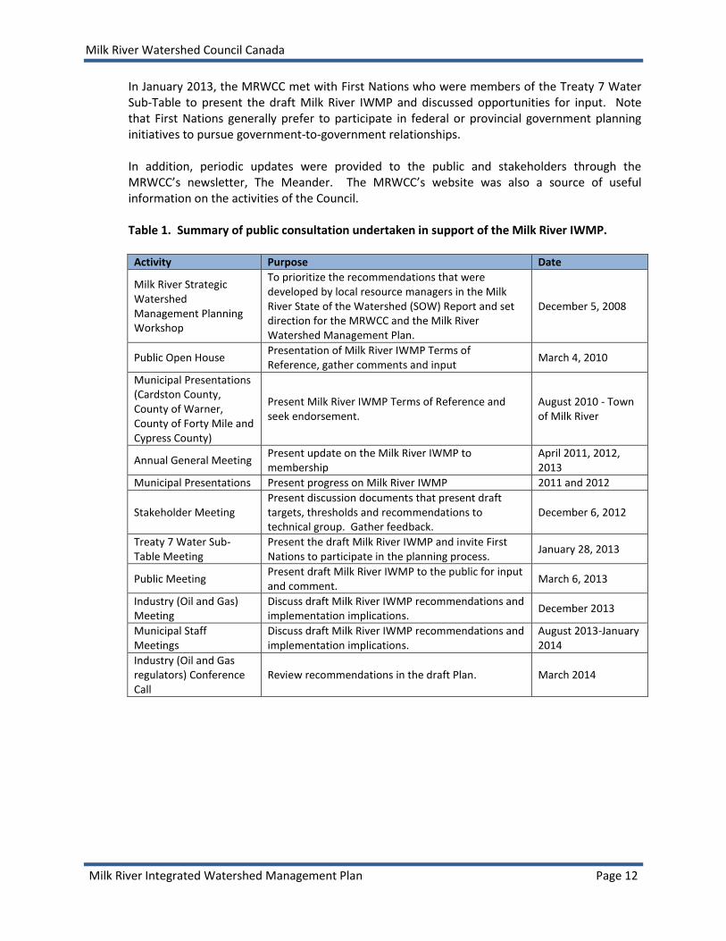
7.0 PUBLIC ENGAGEMENT AND FEEDBACK PROCESS The MRWCC frequently consulted with stakeholders and the public in accordance with the Framework for Water Management Planning (AENV 1999) to ensure that the Milk River IWMP reflects local objectives and ideals. Table 1 summarizes the public engagement and feedback opportunities completed during the IWMP development.
Milk River Watershed Council Canada
Milk River Integrated Watershed Management Plan Page 12
In January 2013, the MRWCC met with First Nations who were members of the Treaty 7 Water Sub-Table to present the draft Milk River IWMP and discussed opportunities for input. Note that First Nations generally prefer to participate in federal or provincial government planning initiatives to pursue government-to-government relationships. In addition, periodic updates were provided to the public and stakeholders through the MRWCC’s newsletter, The Meander. The MRWCC’s website was also a source of useful information on the activities of the Council. Table 1. Summary of public consultation undertaken in support of the Milk River IWMP.
Activity Purpose Date
Milk River Strategic Watershed Management Planning Workshop
To prioritize the recommendations that were developed by local resource managers in the Milk River State of the Watershed (SOW) Report and set direction for the MRWCC and the Milk River Watershed Management Plan.
December 5, 2008
Public Open House Presentation of Milk River IWMP Terms of Reference, gather comments and input
March 4, 2010
Municipal Presentations (Cardston County, County of Warner, County of Forty Mile and Cypress County)
Present Milk River IWMP Terms of Reference and seek endorsement.
August 2010 - Town of Milk River
Annual General Meeting Present update on the Milk River IWMP to membership
April 2011, 2012, 2013
Municipal Presentations Present progress on Milk River IWMP 2011 and 2012
Stakeholder Meeting Present discussion documents that present draft targets, thresholds and recommendations to technical group. Gather feedback.
December 6, 2012
Treaty 7 Water Sub-Table Meeting
Present the draft Milk River IWMP and invite First Nations to participate in the planning process.
January 28, 2013
Public Meeting Present draft Milk River IWMP to the public for input and comment.
March 6, 2013
Industry (Oil and Gas) Meeting
Discuss draft Milk River IWMP recommendations and implementation implications.
December 2013
Municipal Staff Meetings
Discuss draft Milk River IWMP recommendations and implementation implications.
August 2013-January 2014
Industry (Oil and Gas regulators) Conference Call
Review recommendations in the draft Plan. March 2014

Milk River Watershed Council Canada
Milk River Integrated Watershed Management Plan Page 13
8.0 RECOMMENDATIONS AND IMPLEMENTATION STRATEGY
8.1 SURFACE WATER QUANTITY Objective 1. As one component of the IWMP, develop an abbreviated Approved Water Management Plan (AWMP) under the provincial Water Act that:
a) Authorizes Alberta Environment and Sustainable Resource Development to consider applications for transfers of water allocations in the Milk River basin.
b) Specifies matters and factors that must be considered by Alberta Environment and Sustainable Resource Development when reviewing applications for transfers of water allocations.
Objective 2. Recommend strategies that enhance the delivery of apportioned shares of water (as outlined in the Boundary Waters Treaty 1909) while maintaining environmental integrity in the Milk River watershed for both Alberta and Montana. Objective 3. Recommend water conservation strategies that promote the efficient use of water for all sectors (i.e., municipal, industrial, irrigation, recreation).
8.1.1 Outcome and Goals
Water is managed in a manner that benefits communities while meeting the needs of the aquatic and riparian environment. Goals
Water sharing disputes are resolved.
An improved economy in the Milk River watershed exists due to a secure supply of water.
Information on water use in the Milk River watershed is available to the public.
8.1.2 Recommendations Milk River as a transboundary watershed where inter-basin transfers occur
a) The Provincial and Federal governments should better recognize that the Milk River
watershed is a basin where inter-basin water transfers occur (e.g., Boundary Water Treaty 1909 allows for water from St. Mary River to be diverted to the Milk River; in addition, Ridge Reservoir water may flow through Verdigris, and a water pipeline from the Oldman River basin provides water to the Village of Warner). The St. Mary and Milk rivers are connected through the St.Mary-Milk River Diversion, with the Milk River comprised mainly of St. Mary River water for much of the growing season (April to October). Future water decisions should be considered with this understanding.

Milk River Watershed Council Canada
Milk River Integrated Watershed Management Plan Page 14
Approved Water Management Plan
b) On completion of the Montana-Alberta
Transboundary Water Management Initiative’s report regarding improvements to the shared access to water in the St. Mary and Milk rivers, an Approved Water Management Plan (WMP) should be completed under the provisions of the Water Act. The Approved WMP should include recommendations related to the use of water license allocation transfers in the basin.
c) ESRD should collaborate with stakeholders to
determine how to best address desired flow regimes within the context of the 1909 Boundary Waters Treaty once the work of the Montana-Alberta Water Management Initiative is complete. The review may consider the development of Water Conservation Objectives. Note that the Milk River is considered an artificial system (i.e., natural flows in the Milk River are augmented by St. Mary River flows).
Timing and Duration of Flows to Enhance Environment and Recreation Opportunities
d) Flows from the St. Mary River diversion should occur when ice cover has melted on the
Alberta reach of the Milk River to reduce ice scour and subsequent erosion impacts to streambanks.
e) Flows from the St. Mary River diversion should increase and decrease in a manner that will reduce streambank erosion and promote development of functioning riparian areas.
f) A St. Mary River diversion shut-down date of October 1st should be considered to extend
the recreation usability of the Milk River in Alberta, weather permitting, and improve late season flows for aquatic life.
g) Flows from the St. Mary River diversion should be released to maintain a minimum of 12
m3/s (424 cfs) and maximum 26 m3/s (918 cfs) in the Milk River from May through October,
when possible, to support safe river navigation (i.e., allow recreational uses including
tubing, canoeing and kayaking). Optimal recreational flows as identified at the Town of Milk
River gauging station should be maintained in a range of 18 m3/s to 25 m3/s (636 cfs to 883
cfs) to provide the greatest opportunity for recreational use from the Town of Milk River to
Deer Creek Bridge (the area identified as most commonly used by recreational enthusiasts).
Note that the average summer flows range between 18 m3/s to 20 m3/s (636 cfs to 706 cfs).
Refer to Appendix B (Page 92) for an evaluation of recreational flows.
Water Conservation Objectives (WCOs) pertain to the amount and quality of water established by the Director (an ESRD staff member having delegated authority) to be necessary for the:
Protection of a natural water body or its aquatic environment, or any part of them,
Protection of tourism, recreational, transportation or waste assimilation uses of water, or
Management of fish and wildlife.
Water conservation objectives may also include water necessary for the rate of flow of water or water level requirements.
Milk River Watershed Council Canada
Milk River Integrated Watershed Management Plan Page 15
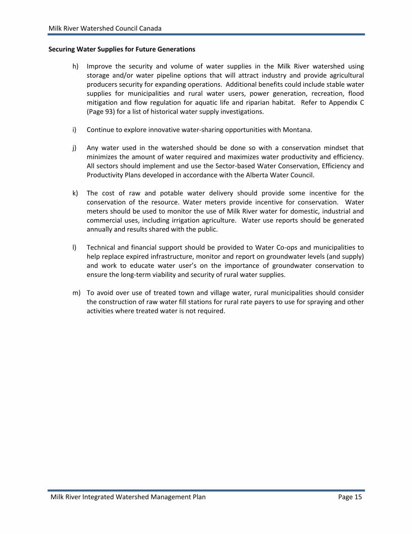
Securing Water Supplies for Future Generations
h) Improve the security and volume of water supplies in the Milk River watershed using storage and/or water pipeline options that will attract industry and provide agricultural producers security for expanding operations. Additional benefits could include stable water supplies for municipalities and rural water users, power generation, recreation, flood mitigation and flow regulation for aquatic life and riparian habitat. Refer to Appendix C (Page 93) for a list of historical water supply investigations.
i) Continue to explore innovative water-sharing opportunities with Montana. j) Any water used in the watershed should be done so with a conservation mindset that
minimizes the amount of water required and maximizes water productivity and efficiency. All sectors should implement and use the Sector-based Water Conservation, Efficiency and Productivity Plans developed in accordance with the Alberta Water Council.
k) The cost of raw and potable water delivery should provide some incentive for the
conservation of the resource. Water meters provide incentive for conservation. Water meters should be used to monitor the use of Milk River water for domestic, industrial and commercial uses, including irrigation agriculture. Water use reports should be generated annually and results shared with the public.
l) Technical and financial support should be provided to Water Co-ops and municipalities to
help replace expired infrastructure, monitor and report on groundwater levels (and supply) and work to educate water user’s on the importance of groundwater conservation to ensure the long-term viability and security of rural water supplies.
m) To avoid over use of treated town and village water, rural municipalities should consider
the construction of raw water fill stations for rural rate payers to use for spraying and other activities where treated water is not required.

Milk River Watershed Council Canada
Milk River Integrated Watershed Management Plan Page 16
8.1.3 Implementation Strategy
RECOMMENDATION RESPONSIBLE JURISDICTION
ACTIONS TIMELINE COMMUNITY
VALUE
8.1.2 a Recognize the Milk River as a watershed where inter-basin transfers occur.
ESRD; Government of Canada
Update GOA and Government of Canada policies and planning documents to acknowledge that inter-basin transfers occur in the Milk River watershed.
H H
8.1.2 b Complete the Approved Water Management Plan.
ESRD Work together with MRWCC and other stakeholders to complete the Approved Water Management Plan that would activate the water license transfer process within the Milk River watershed.
M H
8.1.2 c Explore the applicability of WCOs in the Milk River watershed.
ESRD; MRWCC
Consider existing studies when exploring the applicability of WCOs for Milk River, including:
- Instream Flow Needs Study (Golder 2010) - Milk River Fish Habitat Suitability Criteria Workshop
(Riemersma and Watkinson 2011) - Milk River Open Water Instream Flow Needs (AMEC 2011) - Milk River Winter Instream Flow Needs Study - Winter River2D
Modelling (AMEC 2011)
L L
8.1.2 d Initiate spring flows from St. Mary Diversion when ice cover has melted in Alberta reach of the Milk River.
ESRD; State of Montana
Initiate discussion and develop a strategy with Montana regarding environmental and recreation flows in Alberta within the existing context of the 1909 Boundary Waters Treaty and 1921 IJC Order.
M M
8.1.2 e Ramp flows to reduce erosion and improve riparian recruitment and condition.
ESRD; State of Montana M M
8.1.2 f Extend the St. Mary Diversion shut down date to October 1.
ESRD; State of Montana M M
8.1.2 g Maintain flow regime for recreation.
ESRD; State of Montana M M
8.1.2 h Improve the security and volume of water supplies using storage and/or water pipeline options.
MLAs; Municipalities; Residents; Water Users; MRWCC
MRWCC to gage community support for water storage. Mobilize community support to bring issue forward to the Government of Alberta.
H H-H
GOA; ESRD Finalize a decision regarding storage on the Milk River.
Milk River Watershed Council Canada
Milk River Integrated Watershed Management Plan Page 17
RECOMMENDATION RESPONSIBLE JURISDICTION
ACTIONS TIMELINE COMMUNITY
VALUE
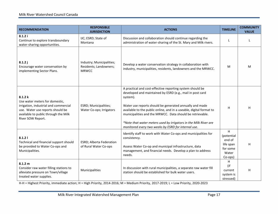
8.1.2 i Continue to explore transboundary water-sharing opportunities.
IJC; ESRD; State of Montana
Discussion and collaboration should continue regarding the administration of water-sharing of the St. Mary and Milk rivers.
L L
8.1.2 j Encourage water conservation by implementing Sector Plans.
Industry; Municipalities; Residents; Landowners; MRWCC
Develop a water conservation strategy in collaboration with industry, municipalities, residents, landowners and the MRWCC.
M M
8.1.2 k Use water meters for domestic, irrigation, industrial and commercial use. Water use reports should be available to public through the Milk River SOW Report.
ESRD; Municipalities; Water Co-ops; Irrigators
A practical and cost-effective reporting system should be developed and maintained by ESRD (e.g., mail in post card system). Water use reports should be generated annually and made available to the public online, and in a useable, digital format to municipalities and the MRWCC. Data should be retrievable. *Note that water meters used by irrigators in the Milk River are monitored every two weeks by ESRD for internal use.
H H
8.1.2 l Technical and financial support should be provided to Water Co-ops and Municipalities.
ESRD; Alberta Federation of Rural Water Co-ops
Identify staff to work with Water Co-ops and municipalities for consistency. Assess Water Co-op and municipal infrastructure, data management, and financial needs. Develop a plan to address needs.
H (potential
end of life span for some
Water Co-ops)
H
8.1.2 m Consider raw water filling stations to alleviate pressure on Town/village treated water supplies.
Municipalities In discussion with rural municipalities, a separate raw water fill station should be established for bulk water users.
H (if
current system is stressed)
H
H-H = Highest Priority, immediate action; H = High Priority, 2014-2016; M = Medium Priority, 2017-2019; L = Low Priority, 2020-2023

Milk River Watershed Council Canada
Milk River Integrated Watershed Management Plan Page 18
8.2 SURFACE WATER QUALITY OBJECTIVES Objective 5. Recommend water quality objectives (WQOs) for four reaches of the Milk River
(i.e., North Fork Milk River, Milk River Mainstem (South Fork), Milk River Gravel-bed and Milk River Sand-bed).
8.2.1 Outcomes and Goals
Water and adjacent land uses (that influence water quality) are managed in a manner that meets of the needs of communities while benefitting the aquatic and riparian environments.
Water of high quality is available for human use, communities, terrestrial and aquatic life, irrigation farming, and recreational and industrial users in the Milk River watershed.
Goals
Water quality is maintained, and where possible, improved in all watershed reaches.
Baseline water quality information is available to the public.
Water quality and quantity information is used by resource managers to promote sustainable land and water use and to integrate water management with other uses and human activities.
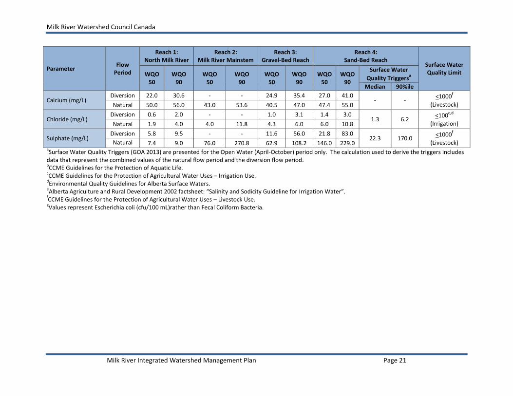
8.2.2 Targets
Targets for surface water quality are presented as Water Quality Objectives (WQOs). Table 3 summarizes the WQO 50 and WQO 90 for the four reaches of the Milk River (Figure 2). Refer to the discussion paper “Surface Water Quality Objectives for the Milk River – Open Water Season” (PESL 2012) for more detail on how the WQOs were determined. In addition to WQOs, the surface water quality triggers established in the South Saskatchewan Region Water Quality Management Framework (GOA 2013) for Reach 4 are provided for comparison (Table 3). There are some notable differences between the WQO 50 and Median trigger values, as well as the WQO 90 and the 90%ile trigger values for Reach 4 due to the different methods and historical time period of data used to calculate the objectives versus the Water Quality Management Framework triggers. Note that the province presents triggers for the open-water season (April-October) which includes both the natural flow period and the diversion
Targets: Identify what is desired or what is to be achieved and can be numerical or written statements. Targets are used to determine how valued components in the watershed rate or compare to acceptable or desired ratings. WQO 50: The water quality objective representing the 50th percentile or median (middle) value in the data set. Fifty percent of the values are above the median and fifty percent are below the median. Corresponds with the Median trigger established by GOA (2013). WQO 90: The water quality objective representing the 90th percentile value in the data set. Ninety percent of the values in the data set are below the 90th percentile and ten percent are above. Corresponds with the 90%ile trigger established by GOA (2013).
Milk River Watershed Council Canada
Milk River Integrated Watershed Management Plan Page 19
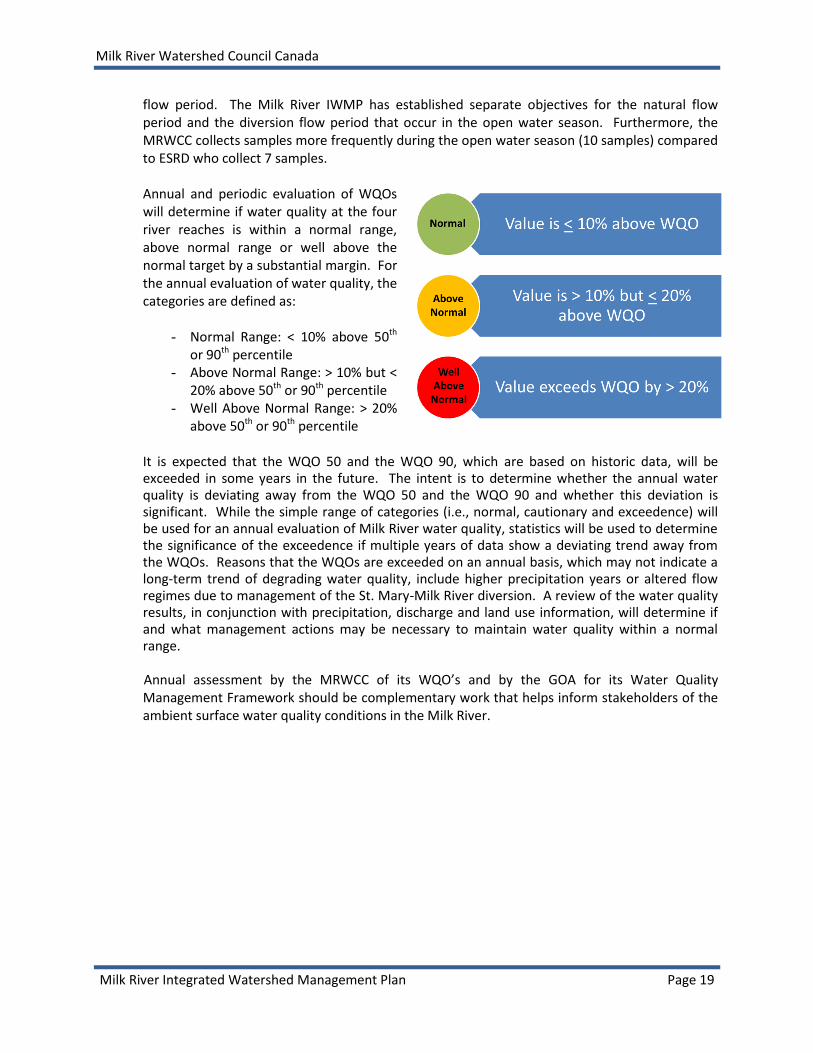
flow period. The Milk River IWMP has established separate objectives for the natural flow period and the diversion flow period that occur in the open water season. Furthermore, the MRWCC collects samples more frequently during the open water season (10 samples) compared to ESRD who collect 7 samples. Annual and periodic evaluation of WQOs will determine if water quality at the four river reaches is within a normal range, above normal range or well above the normal target by a substantial margin. For the annual evaluation of water quality, the categories are defined as:
- Normal Range: < 10% above 50th or 90th percentile
- Above Normal Range: > 10% but < 20% above 50th or 90th percentile
- Well Above Normal Range: > 20% above 50th or 90th percentile
It is expected that the WQO 50 and the WQO 90, which are based on historic data, will be exceeded in some years in the future. The intent is to determine whether the annual water quality is deviating away from the WQO 50 and the WQO 90 and whether this deviation is significant. While the simple range of categories (i.e., normal, cautionary and exceedence) will be used for an annual evaluation of Milk River water quality, statistics will be used to determine the significance of the exceedence if multiple years of data show a deviating trend away from the WQOs. Reasons that the WQOs are exceeded on an annual basis, which may not indicate a long-term trend of degrading water quality, include higher precipitation years or altered flow regimes due to management of the St. Mary-Milk River diversion. A review of the water quality results, in conjunction with precipitation, discharge and land use information, will determine if and what management actions may be necessary to maintain water quality within a normal range.
Annual assessment by the MRWCC of its WQO’s and by the GOA for its Water Quality Management Framework should be complementary work that helps inform stakeholders of the ambient surface water quality conditions in the Milk River.

Milk River Watershed Council Canada
Milk River Integrated Watershed Management Plan Page 20
Table 3. Water quality objectives for four reaches of the Milk River and surface water quality triggers at Reach 4 (Figure 2). Note that the
flow period at Reach 2 is from April-October since flows in this reach are not augmented by the St. Mary River.
Parameter Flow
Period
Reach 1: North Milk River
Reach 2: Milk River Mainstem
Reach 3: Gravel-Bed Reach
Reach 4: Sand-Bed Reach
Surface Water Quality Limit WQO
50 WQO
90 WQO
50 WQO
90 WQO
50 WQO
90 WQO
50 WQO
90
Surface Water
Quality Triggersa
Median 90%ile
Specific Conductivity (µS/cm)
Diversion 165 246 - - 210 398 250 540 248 733
<1000d,e
(Irrigation) Natural 445 512 510 882 570 674 727 936
pH (Value) Diversion 8.12 <6.5
and >9.0
- - 8.20 <6.5 and >9.0
8.24 <6.5 and >8.5
8.23 8.43 >6.5 and <9.0b,d
Natural 8.39 8.44
<6.5 and >9.0
8.41 8.46
Total Dissolved Solids (mg/L)
Diversion 89 147 - - 112 240 140 330 140 488
<500 and
<3500c,d
(Irrigation) Natural 257 294 304 546 342 418 450 593
Total Suspended Solids (mg/L)
Diversion 16 59 - - 56 282 131 384 107 304 -
Natural 5 55 14 247 7 267 13 228
Total Phosphorus (mg/L)
Diversion 0.014 0.037 - - 0.044 0.148 0.088 0.220 0.079 0.193 -
Natural 0.012 0.100 0.019 0.186 0.013 0.504 0.013 0.086
Total Dissolved Phosphorus (mg/L)
Diversion 0.003 0.007 - - 0.003 0.010 0.004 0.011 0.003 0.006 -
Natural 0.005 0.066 0.006 0.015 0.005 0.173 0.004 0.021
Total Nitrogen (mg/L)
Diversion 0.240 0.468 - - 0.325 0.667 0.365 0.668 0.32 0.59 -
Natural 0.900 1.578 0.600 1.360 0.680 1.637 0.320 1.400
Nitrate-Nitrogen (mg/L)
Diversion 0.057 0.114 - - 0.043 0.133 0.030 0.120 0.031 0.123
<2.93b,d
(Aquatic Life) Natural 0.387 0.729 0.025 0.440 0.096 0.478 0.036 0.532
Total Ammonia (mg/L)
Diversion 0.025 0.081 - - 0.025 0.084 0.025 0.068 0.025 0.070
Varies with pH &
Temperatureb,d
Natural 0.025 0.165 0.030 0.092 0.025 0.094 0.025 0.066
Fecal Coliform Bacteria (cfu/100 mL)
Diversion 27 140 - - 68 272 78 280 57
g 230
g
<100c
(Irrigation) Natural 55 668 77 619 49 522 29 163
Turbidity (NTU) Diversion 9.1 39.2 - - 33.0 148.0 58 158
60 170 - Natural 1.8 2.7 12.0 74.0 2.7 6.2 12 178
Milk River Watershed Council Canada
Milk River Integrated Watershed Management Plan Page 21
Parameter Flow
Period
Reach 1: North Milk River
Reach 2: Milk River Mainstem
Reach 3: Gravel-Bed Reach
Reach 4: Sand-Bed Reach
Surface Water Quality Limit WQO
50 WQO
90 WQO
50 WQO
90 WQO
50 WQO
90 WQO
50 WQO
90
Surface Water
Quality Triggersa
Median 90%ile
Calcium (mg/L) Diversion 22.0 30.6 - - 24.9 35.4 27.0 41.0
- - <1000
f
(Livestock) Natural 50.0 56.0 43.0 53.6 40.5 47.0 47.4 55.0
Chloride (mg/L) Diversion 0.6 2.0 - - 1.0 3.1 1.4 3.0
1.3 6.2 <100
c,d
(Irrigation) Natural 1.9 4.0 4.0 11.8 4.3 6.0 6.0 10.8
Sulphate (mg/L) Diversion 5.8 9.5 - - 11.6 56.0 21.8 83.0
22.3 170.0 <1000
f
(Livestock) Natural 7.4 9.0 76.0 270.8 62.9 108.2 146.0 229.0 aSurface Water Quality Triggers (GOA 2013) are presented for the Open Water (April-October) period only. The calculation used to derive the triggers includes
data that represent the combined values of the natural flow period and the diversion flow period. bCCME Guidelines for the Protection of Aquatic Life.
cCCME Guidelines for the Protection of Agricultural Water Uses – Irrigation Use.
dEnvironmental Quality Guidelines for Alberta Surface Waters.
eAlberta Agriculture and Rural Development 2002 factsheet: “Salinity and Sodicity Guideline for Irrigation Water”.
fCCME Guidelines for the Protection of Agricultural Water Uses – Livestock Use.
gValues represent Escherichia coli (cfu/100 mL)rather than Fecal Coliform Bacteria.

Milk River Watershed Council Canada
Milk River Integrated Watershed Management Plan Page 22
8.2.3 Recommendations
a) Continue with the Milk River Long-Term Water Monitoring Program at select locations to assess and evaluate water quality and compare with water quality objectives in this plan.
b) Continue and/or expand tributary monitoring in order to support local watershed groups
and municipalities. WQOs may be considered for priority tributaries such as:
Eastern Tributaries (Inter-provincial streams)
Red Creek (support Watershed Stewardship Group activity)
Verdigris Coulee (A significant source of poor water quality [i.e., high salts] when flowing).
c) The MRWCC and Alberta government officials are encouraged to explore with their
Montana counterparts how water flows might be managed, under existing treaty requirements and agreements, to achieve environmental and water quality objectives in Canada.
d) Streambank stabilization measures should be applied, where feasible, to reduce erosion
and subsequent sediment transport. e) Riparian condition should be improved, where needed, to restore functions that maintain
water quality. f) Implementation of industry Beneficial Management Practices (BMPs) should be promoted
to protect water quality:
For Municipalities:
Stormwater should be captured and treated prior to release into the Milk River.
For future developments that require the release of stormwater to surface water (either to the Milk River, its tributaries or lakes and wetlands), the release should be made at an appropriate rate and volume (e.g., predevelopment rates and volumes) to reduce the occurrence of streambank and gully erosion, flooding downstream and changes to native vegetation communities.
Appropriate water body and riparian setbacks should be implemented for developments located adjacent to the Milk River and its tributaries.
Residential, commercial and industrial areas should be designed using Low Impact Development (LID) principles.
For Agriculture:
Livestock grazing plans should include the creation of riparian pastures within a rotational grazing system.
Implementation of remote watering systems.
Proper siting for livestock wintering areas to control runoff.
Minimizing surface runoff of fertilizers and pesticides from cropped fields.
For Other Industry:
Abide by the Code of Practice for Watercourse Crossings.

Milk River Watershed Council Canada
Milk River Integrated Watershed Management Plan Page 23
Abide by the Code of Practice for Pipelines and Telecommunication Lines.
Watercourse, waterbody and riparian setbacks should be observed. g) Establish a Milk River Water Quality Review Committee within the MRWCC’s Research and
Monitoring Team to identify sources contributing to poor quality water and address water quality issues that may arise from the water monitoring program.
8.2.4 Implementation Strategy
RECOMMENDATION RESPONSIBLE JURISDICTION
ACTIONS TIMELINE COMMUNITY
VALUE
8.2.3 a Continue long-term water quality monitoring on the mainstem Milk River.
MRWCC; ESRD; AEMERA Secure funding and allocate budget
dollars to continue with the long-term water quality monitoring and to continue and/or expand monitoring program at tributaries.
H H
8.2.3 b Continue and/or expand tributary monitoring and establish WQOs for select tributaries.
MRWCC; ESRD; AEMERA
M M
8.2.3 c Identify appropriate flow regime to meet WQOs.
MRWCC; ESRD, MT Continue work to establish Instream Flow Needs.
M H
8.2.3 d Streambank stabilization measures implemented.
Landowners; Leaseholders; ESRD; DFO; AARD
Explore options for stabilizing streambanks and seek partnerships to implement projects.
M H
MRWCC; ESRD; DFO; AARD
Support Watershed Stewardship Groups who want to implement small-scale bioengineering projects.
M H
8.2.3 e Improve riparian condition, where needed, to restore/maintain water quality function.
MRWCC; ESRD; Municipalities; NGOs
Monitor and report on riparian condition. Provide support to landowners and leaseholders who wish to improve riparian condition.
M M
MRWCC; ESRD; Landowners; leaseholders; NGOs
Explore options for improving riparian condition and seek partnerships to implement projects.
M M
8.2.3 f Follow industry BMPs.
MRWCC; Municipalities
MRWCC to promote BMPs through workshops, newsletters and by disseminating information to industry.
M-H M
Municipalities; Industry
Seek new information, management practices within industry organizations.
M-H L
8.2.3 g Establish a Water Quality Review Committee.
MRWCC; ESRD; Municipalities
Identify Water Quality Review Committee members and establish a meeting date, at least once annually.
H H
H = High Priority, 2014-2016; M = Medium Priority, 2017-2019; L = Low Priority, 2020-2023

Milk River Watershed Council Canada
Milk River Integrated Watershed Management Plan Page 24
8.3 GROUNDWATER Objective 4. Recommend water conservation strategies that promote the efficient use of water for all sectors (i.e., municipal, industrial, irrigation). Objective 7. Recommend groundwater protection and conservation measures for vulnerable areas, including the Whisky Valley and Milk River aquifers (Figure 3).
8.3.1 Outcomes and Goals
Groundwater is recognized as a valuable resource in the Milk River watershed and management is in place to provide for its protection and conservation.
Goals
Groundwater is available and able to provide for domestic and livestock uses, as well as upland functions (e.g., contribution of inflow to the water balance of large permanent wetlands, to streamflow and wildlife habitat where groundwater seeps are prevalent).
Groundwater quality is not adversely affected by human activities and land uses such as the extraction of energy and aggregate resources, or by activity that leads to contamination.
Groundwater is mapped, interactions are understood and the resource is properly managed.
8.3.2 Targets and Thresholds Groundwater Supply Target
Existing and future groundwater and surface water demands are met with no observed decreasing trend in groundwater levels attributed to those demands.
Groundwater Quality Target Maintain the existing quality of groundwater (i.e., background or normal condition) throughout the watershed to provide for domestic and livestock drinking water.
Groundwater: Significant groundwater resources in the Milk River watershed include the Milk River Sandstone and Whisky Valley aquifers. The Milk River and these two aquifers are interconnected; water from the Milk River percolates into the Whisky Valley Aquifer, particularly when withdrawals from the aquifer are significant. Note that groundwater wells that are hydrologically connected to surface water are considered surface water. Aquifer: An underground bed or layer of sand, earth, gravel or porous stone that contains water or permits its passage (Armantrout 1998).

Milk River Watershed Council Canada
Milk River Integrated Watershed Management Plan Page 25
8.3.3 Recommendations3
Groundwater Supply
a) Federal, provincial and municipal decision makers should recognize the unique and important inter-connection between the Milk River, the Milk River Sandstone Aquifer and the Whisky Valley Aquifer in order to manage these resources accordingly.
b) A Groundwater Management Plan should be developed, that would include an assessment
of the potential for increased use of the Milk River Aquifer, the Whisky Valley Aquifer and other vulnerable groundwater sources. In the short-term, test wells should be drilled to confirm that the volume and quality of groundwater available in areas proposed for development are suitable for use and do not impact on existing users or substantially reduce streamflows in the Milk River. For the Whisky Valley Aquifer, the Whisky Valley Aquifer Model could be used to explore potential impacts at particular locations. Appendix D (Page 96) shows where areas of the Whisky Valley Aquifer are thicker and may have good potential for additional supply.
c) As part of the Groundwater Management Plan in “b”, identify alternative sources and delivery mechanisms of water (e.g., cisterns, water hauling and pipeline) where groundwater supplies are limited in volume or quality.
d) Technical and financial support should be provided for the proper decommissioning of abandoned water wells.
3 Many of the recommendations made for groundwater were taken from “Report on Development of a
Management/Protection Plan for the Whisky Valley Aquifer, County of Warner, Alberta” prepared for the Milk River West Water User’s Co-op, Milk River, AB (Golder Associates Ltd. 2004).

Milk River Watershed Council Canada
Milk River Integrated Watershed Management Plan Page 26
Figure 3. Milk River watershed aquifer vulnerability map showing the Milk River and Whisky Valley Aquifers. (Refer to Appendix D [Page 96] for a second aquifer vulnerability mapped prepared by Golder Associates (2004).
Milk River Watershed Council Canada
Milk River Integrated Watershed Management Plan Page 27
Groundwater Quality e) Review groundwater quality and investigate the type of targets that might be applicable to
resources in the watershed. Consider an interim groundwater quality target as a benchmark for future monitoring efforts.
f) Manage new development within “medium-high” and “high” risk areas as defined on the Aquifer Vulnerability Map (Figure 3) to minimize potential impacts to groundwater quality. Land uses that should not be permitted within these areas unless safeguards are in place to reduce risks, include:
i. Those that require the storage or handling of hazardous substances that could be released into the ground, or
ii. Those uses that include high water consumption (e.g., subdivisions, confined feeding operations). Table 7 provides examples of the kind of land uses/activities that might be excluded from the Whisky Valley Aquifer area.
Land use restrictions (Table 7; Figure 4) should be applied to the entire Whisky Valley Aquifer area which also partly coincides with the Milk River floodplain to protect these environmentally sensitive areas.
g) Appropriate BMPs should be applied when storing or handling hazardous materials that could impact surface waters and inadvertently reach groundwater and vice versa.
h) Appropriate Municipal Development Plan policies should be adapted to enhance the
protection of the quality and quantity of groundwater in the Milk River Aquifer, the Whisky Valley Aquifer and other vulnerable groundwater sources. Communal well capture zones (Figure 5), within the region of the Whisky Valley Aquifer in particular, should be identified in Land Use Bylaws as environmentally sensitive areas (Golder Associates 2004); land use safeguards should be adopted to protect such environmentally sensitive areas.
i) Potential new water contaminant sources overlying the Milk River Aquifer and Whisky
Valley Aquifer and in recharge areas should be identified on an on-going basis primarily through the review of development applications by appropriate authorities.4
4 An appropriate authority may include the County of Warner No. 5 Subdivision and Development Authority (SDA) which is a
committee of County Council.

Milk River Watershed Council Canada
Milk River Integrated Watershed Management Plan Page 28
Table 7. List of discretionary and prohibited land uses5 that could be applied to vulnerable groundwater areas, particularly the Whisky Valley Aquifer (County of Warner Land Use Bylaw No. 831-03 [Golder Associates 2004]).
Discretionary Land Uses
Agricultural services Kennels
Airports and airstrips Private recreation
Autobody repair and paint shop Grain elevators
Automotive dealership Highway commercial
Automotive repair and service shop Home occupations
Campgrounds Intensive horticulture
Cut-off country residential Isolated single lot commercial
Farm machinery and industrial vehicle sales and service
Isolated single lot country residential (for subdivision)
Secondary suites Isolated single lot industry
Public/institutional Stockpiles (e.g., manure, potatoes, aggregate)
Public recreation Public or private utilities
Resource extraction and associated works (e.g., pipelines)
Wind energy conversion systems
Second or more residences (re: sections 45-47)
Prohibited/Restricted Uses
Anhydrous ammonia storage Hazardous/noxious uses
Grouped country residential Stripping and sale of topsoil
Grouped industrial developments Confined Feeding Operations
Public Education and Awareness
j) An education program should be developed to inform residents of the importance of
groundwater supply and quality to the community and the need for aquifer protection and conservation measures6. In particular, the program should be targeted to community members who live or work in areas that overly or are near vulnerable groundwater sources, such as the Whisky Valley Aquifer and its recharge area.
Monitoring k) In addition to on-going monitoring of water quality for the four existing Water Co-op wells,
up-gradient “sentry” monitoring wells should be established in the Whisky Valley Aquifer and routinely monitored for indicator parameters. This would allow an early warning of the contamination or gradual degradation of the water before it reached any of the four critical water supply wells. The recommended location of the sentry monitoring wells is shown approximately on Figure 4. The recommended parameters for routine, quarterly monitoring include: electrical conductivity nitrate plus nitrite, total dissolved solids, chloride, phenolics, hardness, total organic carbon and BTEX (benzene, toluene, ethylbenzene, xylenes).
5 The control of land use in the County of Warner No. 5 is guided by its Subdivision and Development Authority (SDA), which is a committee of County Council.

Milk River Watershed Council Canada
Milk River Integrated Watershed Management Plan Page 29
l) Establish critical water levels within the Milk River and Whisky Valley aquifers and other vulnerable groundwater sources. If aquifer water levels drop below a specified level, or if a water quality parameter exceeds its target, specific actions such as re-sampling or notifying the Water Co-op or ESRD should be triggered. If possible, all routine monitoring results should be posted on a Water Co-op or municipal internet site to allow access by all the water users.
m) Groundwater quantity in the Whisky Valley Aquifer should also be monitored by continuing
to measure water use from the communal wells and water level in nearby monitoring wells. n) The results of the on-going groundwater quality and quantity monitoring programs should
be compiled into an electronic database, reviewed on a regular basis and reported in the Milk River State of the Watershed Report, as a minimum. The review should include a comparison with established groundwater guidelines and water level targets.
o) The logs of any new wells drilled in the area, including private wells and those drilled as part
of the research and monitoring programs, should be added to the Whisky Valley Aquifer model, along with any water level data to increase its accuracy and value for future use in managing the Whisky Valley Aquifer (Golder Associates 2004).
Emergency Preparedness and Contingency Plan p) Emergency Preparedness and Contingency Plans (EPCPs) should be developed for each of
the Water Co-op water supplies to minimize the impact of disruption6, primarily related to the chemical contamination of groundwater, on water users.
Research q) The potential interconnection of the Whisky Valley Aquifer with the Milk River is an
important factor in the security and future development of the Whisky Valley Aquifer. Further investigation should be carried out to understand this relationship.
r) The baseflow contribution from groundwater to the Milk River should be better evaluated
with streamflow measurements. s) Continue to support the Milk River Transboundary Aquifer Project (MiRTAP) to better
understand the Milk River Aquifer and hydrogeological processes and interactions.
6 Periodic emergencies or disruptions of supply may occur due to natural disasters, chemical contamination, or physical
disruption. Disruptions may vary in time (a few hours) or an undetermined length of time in the case of contamination. Contamination may interfere with the use of the water supply or its pumping, treatment or supply to consumers.

Milk River Watershed Council Canada
Milk River Integrated Watershed Management Plan Page 30
Figure 5. Existing and proposed land use restrictions map.
RESTRICTED ACTIVITIES: CONFINED FEEDING OPERATIONS, ANHYDROUS AMMONIA STORAGE, HAZARDOUS/NOXIOUS USES, GROUPED COUNTRY RESIDENTIAL, STRIPPING AND SALE OF TOPSOIL, GROUPED INDUSTRIAL DEVELOPMENTS

Milk River Watershed Council Canada
Milk River Integrated Watershed Management Plan Page 31
8.3.4 Implementation Strategy
RECOMMENDATION RESPONSIBLE JURISDICTION
ACTIONS TIMELINE COMMUNITY
VALUE
8.3.3 a Recognize the interconnection among the Milk River, the Milk River Sandstone Aquifer and the Whisky Valley Aquifer.
ESRD; Municipalities
Recognize the interconnection of surface and groundwater in relevant policy and planning document (e.g., provincial policy documents that describe the process to determine groundwater-surface water connection).
H H
8.3.3 b Develop a groundwater Management Plan to maintain groundwater yield and quality in the long-term.
ESRD; Geological Survey of Canada
ESRD should work closely with the Geological Survey of Canada and other stakeholders to complete a Groundwater Management Plan that would include the Milk River Aquifer, Whisky Valley Aquifer and other vulnerable groundwater sources. This may be accomplished, in part, through the Milk River Transboundary Aquifer Project (MiRTAP).
M H
8.3.3 c Consider alternative water supplies.
ESRD; Municipalities; Landowners
Landowners should work with appropriate authorities to identify alternative sources of water and delivery mechanisms (e.g., cisterns, water hauling) where groundwater supplies are limited in volume or quality.
M-H H
8.3.3 d Provide technical and financial assistance to decommission abandoned wells.
Government of Canada; ESRD; Landowners
Secure funding from federal and provincial programs (e.g., Growing Forward II). Provide additional funding for high risk wells located in vulnerable aquifer areas.
Ongoing H
8.3.3 e Review groundwater quality in the Milk River watershed and investigate the type of targets that may apply.
ESRD
Interim groundwater quality targets should be set at a level 10% higher than the seasonally high concentration for key parameters measured at individual wells, or at the drinking water standard concentration, if it represents less than a 10% increase. Key parameters include: electrical conductivity, nitrate+nitrite nitrogen, total dissolved solids, chloride, phenolics, hardness, total organic carbon and BTEX (benzene, toluene, ethylbenzene, xylenes). Example: If the highest concentration of total dissolved solids is measured at 500 mg/L then the target concentration should be set at <550 mg/L; seasonal variation of groundwater quality occurs, so separate targets may be necessary to reflect spring vs. fall conditions. If the measured TDS concentration (or the measured TDS concentration + 10%) is higher than the recommended drinking water standard concentration, then the drinking water standard should apply.
M-H H
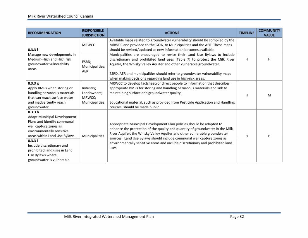
Milk River Watershed Council Canada
Milk River Integrated Watershed Management Plan Page 32
RECOMMENDATION RESPONSIBLE JURISDICTION
ACTIONS TIMELINE COMMUNITY
VALUE
8.3.3 f Manage new developments in Medium-High and High risk groundwater vulnerability areas.
MRWCC Available maps related to groundwater vulnerability should be compiled by the MRWCC and provided to the GOA, to Municipalities and the AER. These maps should be revised/updated as new information becomes available.
H H ESRD; Municipalities; AER
Municipalities are encouraged to revise their Land Use Bylaws to include discretionary and prohibited land uses (Table 7) to protect the Milk River Aquifer, the Whisky Valley Aquifer and other vulnerable groundwater. ESRD, AER and municipalities should refer to groundwater vulnerability maps when making decisions regarding land use in high-risk areas.
8.3.3 g Apply BMPs when storing or handling hazardous materials that can reach surface water and inadvertently reach groundwater.
Industry; Landowners; MRWCC; Municipalities
MRWCC to develop factsheet/or direct people to information that describes appropriate BMPs for storing and handling hazardous materials and link to maintaining surface and groundwater quality. Educational material, such as provided from Pesticide Application and Handling courses, should be made public.
H M
8.3.3 h Adapt Municipal Development Plans and identify communal well capture zones as environmentally sensitive areas within Land Use Bylaws. Municipalities
Appropriate Municipal Development Plan policies should be adapted to enhance the protection of the quality and quantity of groundwater in the Milk River Aquifer, the Whisky Valley Aquifer and other vulnerable groundwater sources. Land Use Bylaws should include communal well capture zones as environmentally sensitive areas and include discretionary and prohibited land uses.
H H
8.3.3 i Include discretionary and prohibited land uses in Land Use Bylaws where groundwater is vulnerable.

Milk River Watershed Council Canada
Milk River Integrated Watershed Management Plan Page 33
RECOMMENDATION RESPONSIBLE JURISDICTION
ACTIONS TIMELINE COMMUNITY
VALUE
8.3.3 j Develop a groundwater education program that highlights the importance of groundwater in the watershed.
ESRD, AARD, Municipalities, MRWCC, Industry (irrigators)
Develop an education program that informs all water consumers of the status and importance of conserving the communal water supply. The use of conservation BMPs should be encouraged along with other management strategies. Material should place the actual threat to the resource in perspective and include:
proper storage, handling and use of hazardous materials (e.g., road de-icing chemicals (for public works and provincial transportation staff), pesticides, fertilizers, fuels and lubricants (for the agricultural community),
proper water well location, maintenance, and abandonment,
adoption of water conservation measures (e.g., the use of low flow facilities, maintaining all taps and stock watering outlets to reduce leaks and overflows)
7and metering water usage from the aquifers.
the use of Environmental Farm Plans (EFPs) The extent of aquifer boundaries and areas where groundwater sources are vulnerable should be highlighted.
H
M
Methods used to raise community awareness of groundwater should include:
News media features and advertisements;
preparation of pamphlets and posters;
a grade-school program;
the placement of signs at strategic locations identifying the Aquifer and recharge areas;
presentations and workshops offered to local agricultural and community groups.
M
8.3.3 k Establish “early detection” sentry monitoring wells for water level.
ESRD; Water Co-ops
Establish sentry monitoring wells and use these wells to help determine the extent of the water capture zones for the Water Co-op wells.
H H
8.3.3 l Establish critical water levels.
ESRD; Geological Survey of Canada
Critical water levels within the Milk River and Whisky Valley aquifers should be established. Continue and maybe expand the groundwater quality monitoring program.
H H
7 Each of the three water co-ops limit each of their customers to a water withdrawal of approximately 2 gpm by equipping each inlet with a flow control valve.
This represents a potential withdrawal of 2880 gpd for domestic use, stock watering and general farm use.

Milk River Watershed Council Canada
Milk River Integrated Watershed Management Plan Page 34
RECOMMENDATION RESPONSIBLE JURISDICTION
ACTIONS TIMELINE COMMUNITY
VALUE
8.3.3 m Monitor groundwater quantity in wells.
ESRD; MRWCC; Water Co-ops
Establish a voluntary water level monitoring program to gather information about groundwater supplies.
M M
8.3.3 n Develop and maintain electronic database to store groundwater quality and quantity data from monitoring wells. Interpret results.
ESRD; AEMERA
ESRD should maintain the groundwater quality and quantity data base (e.g., water use reporting system) for the Water Co-ops and Milk River community. The results of the monitoring should be reviewed, interpreted and shared.
H H
MRWCC Report results of the groundwater quality and quantity monitoring program in the Milk River State of the Watershed Report.
M H
8.3.3 o Manage the Whisky Valley Aquifer model.
ESRD; County of Warner
The Whisky Valley Aquifer model should be managed and updated by the Province.
M M
8.3.3 p Emergency Preparedness and Contingency Plan developed.
ESRD; Water Co-op; MRWCC
Funding should be provided from the province to Water Co-ops to assist with the preparation of emergency plans. (Funding may be available through the SSRP implementation phase source water protection plans and may require the MRWCC to be the funding sponsor.) The Emergency Preparedness and Contingency Plan should include:
- A groundwater vulnerability map - Documentation of existing well capacities; - A monitoring program for early detection of aquifer contamination; - List of potential conditions which could result in loss of water supply; - A protocol for notification of appropriate officials and water consumers; - Prevention and emergency procedures for response to groundwater
contamination in a communal well capture zone or highly vulnerable aquifer area;
- Identification of available environmental cleanup or water treatment contractors; and
- Identification of replacement groundwater supplies or potential alternate water sources for use in the event of well or aquifer contamination.
H H
8.3.3 q Research the interconnection between the Whisky Valley Aquifer and Milk River.
ESRD; Geological Survey of Canada
The drilling of about six test holes, and installation and sampling of monitoring wells, close to the river and along the length of the aquifer would improve the understanding of this relationship.
M M

Milk River Watershed Council Canada
Milk River Integrated Watershed Management Plan Page 35
RECOMMENDATION RESPONSIBLE JURISDICTION
ACTIONS TIMELINE COMMUNITY
VALUE
8.3.3 r Research further baseflow contributions to the Milk River.
ESRD; Environment Canada
Continue with previous work to better understand baseflow contributions to Milk River streamflows.
M-L M
8.3.3 s Continue work on the Milk River Transboundary Aquifer Project.
Geological Survey of Canada; ESRD; MRWCC; Municipalities
Continue important work with MiRTAP to better understand groundwater flow, volume and use and to ultimately develop a transboundary Milk River Aquifer Management Plan.
H H
H = High Priority, 2014-2016; M = Medium Priority, 2017-2019; L = Low Priority, 2020-2023

Milk River Watershed Council Canada
Milk River Integrated Watershed Management Plan Page 36
8.4 RIPARIAN AREAS AND WETLANDS
Note to Reader: Agricultural producers and resource managers require flexibility for day-to day operations on the farm or ranch. Current practices in the watershed include wintering livestock in riparian areas; this activity should be viewed as a rotational grazing strategy, similar to the use of riparian pastures during the growing season. During winter months, riparian areas provide shelter and forage. Livestock are generally removed from riparian areas as spring pasture becomes available.
Objective 6. Recommend minimum setback requirements for development from the Milk River and its tributaries and recommend appropriate management strategies to protect and/or enhance riparian and aquatic ecosystems.
8.4.1 Outcomes and Goals
Healthy, functioning riparian areas contribute to streambank stability, good water quality, forage, shelter and biodiversity in the Milk River watershed.
8.4.2 Targets and Thresholds
Adopt the following recommended targets and thresholds to provide a measurable indication of success in achieving riparian management objectives:
Riparian Health Target: Riparian health scores should fall within the “Healthy” category (i.e., having a score of equal to or greater than 80 for all four river reaches).
Riparian Health Threshold: Riparian health scores should not be less than 70 in all river reaches (70 is the mid-point of the Healthy with Problems” category) (Table 8).
Table 8. Targets and thresholds for riparian health by Milk River reach. Note that the dominant land use for each reach is agricultural.
Reaches Target (Score)
Threshold (Score)
Actual Average Score (as of 2011)
Mainstem Score
Tributary Score
Wetland Score
Lotic
Reach 1: North Fork > 80 70 65 66
-
Reach 2: South Fork Milk River > 80 70 75 -
Reach 3: Gravel Bed Reach > 80 70 58 70
Reach 4: Sand Bed Reach > 80 70 62 77a; 71
b
Reach 5: Eastern Tributaries > 80 70 - 68
Lentic
Wetlands (Entire Watershed) > 80 70
66a; 52
b
aAverage score derived from assessments completed by Cows and Fish.
bAverage score derived from assessments completed by Alberta Conservation Association.
Riparian health score categories are based on methods established by Cows and Fish: Healthy (Score > 80), Healthy with Problems (Score 60-79), Unhealthy (Score < 60).

Milk River Watershed Council Canada
Milk River Integrated Watershed Management Plan Page 37
8.4.3 Recommendations
a) Encourage riparian management strategies to address those river reaches where health indicators were rated in the Healthy with Problems or Unhealthy categories (scores less than the threshold of 70), with top priority assigned to those indicators commonly rating in the Unhealthy category (Table 9 and Table 10). At the discretion of the land manager and dependent on local conditions, possible strategies may include:
i. Vegetative cover of streambanks and floodplain. Provide rest from grazing or other disturbances during the growing season to allow for regrowth, to reduce the amount of bare ground and enable native vegetation to out-compete disturbance-caused and invasive plants for nutrients and water. Manage other human activity (e.g., recreation, transportation, industrial development) to preserve native plant communities.
ii. Invasive and disturbance-caused plants. Livestock grazing strategies should consider distribution, timing and stocking rates that fall within the carrying capacity of each pasture. Provide rest during the growing season and use strategies such as skim grazing and time-controlled grazing to maintain an abundance of native species and to control invasive plants. Other landuse management plans (e.g., industrial development, road construction, sand and gravel extraction) should have reclamation plans and sites should be monitored until reclamation is complete.
iii. Tree/shrub establishment and regeneration. Maintain existing preferred tree
and shrub communities (e.g., poplars, buffaloberry, willows) and prevent the increase of browsing resistant shrub communities (e.g., snowberry, rose, silverberry) resulting from excessive livestock browsing. Provide adequate rest from continuous browsing pressure to promote regeneration of existing preferred trees and shrub communities and improve future reproduction and establishment. Manage distribution, timing, rotation and stocking rate to maintain and increase preferred trees and shrubs.
iv. Streambanks: Root mass protection and alterations. Rotational grazing, off-
stream water developments and other distribution techniques should be used to disperse livestock over large areas of rangeland and prevent cattle from loitering adjacent to the river. Develop riparian pastures, with complementary off-stream watering systems, allow seasonal skim grazing in riparian areas to increase tree and shrub cover and improve streambank stability.
v. Bare ground and physical alterations to riparian area. Improvements to industrial reclamation standards should be encouraged as mandated by provincial, municipal and industrial regulators, as well as monitoring of disturbed areas. Maintain livestock distribution throughout the rangeland, provide effective rest during the growing season and avoid vulnerable periods.
vi. Stream channel incisement and stability. Maintain and increase native trees and
shrubs with deep binding root mass along the river banks. Water management

Milk River Watershed Council Canada
Milk River Integrated Watershed Management Plan Page 38
should consider the erosive potential of excessive flows in the Milk River and the timing of these flows at different times of the year.
Table 9. Combined summary of the condition of riparian health indicators on private and public lands at the various tributary reaches of the Milk River8. Note that the colour green denotes a ‘healthy’ score, yellow denotes a score of ‘healthy with problems’ and red denotes an ‘unhealthy’ score for the indicator. NC means “not collected”.
Riparian Health Indicator Tributaries
Reach 1 Reach 2 Reach 3 Reach 4 Reach 5
Channel incisement
-
Human-caused alterations to polygon
-
Human-caused alterations to banks
-
Human-caused bare ground
-
Root mass protection
-
Disturbance plants
-
Invasive plants
-
Woody vegetation removal other than browse
-
NC
Preferred tree/shrub utilisation
-
Dead and decadent woody material
-
Preferred tree/shrub regeneration
-
Vegetative cover
-
Table 10. Summary of the condition of riparian health indicators at the four Milk River mainstem reaches. Note that the colour green denotes a ‘healthy’ score, yellow denotes a score of ‘healthy with problems’ and red denotes an ‘unhealthy’ score for the indicator. NC means “not collected” and NA means that the indicator was “not applicable” to the given reach. Summary of current health status combines assessment scores from Public and Private lands.
Riparian Health Indicator Mainstem
Reach 1 Reach 2 Reach 3 Reach 4
Floodplain accessibility Human-caused alterations to polygon
NC
Human-caused alterations to banks
Control of flood peak and timing by upstream dam(s)
Removal or addition of water from/to the river systema
Human-caused bare ground
Root mass protection
Disturbance plants
Invasive plants
Total canopy cover of woody species
Woody vegetation removal other than browse
NC
Preferred tree/shrub utilisation Dead and decadent woody material Preferred shrub regeneration
8 Refer to Palliser Environmental Services Ltd. (2012) for a full report on riparian health in the Milk River
watershed.
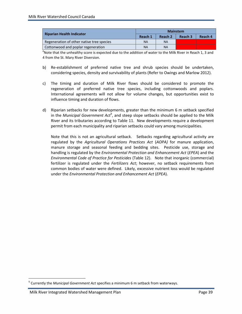
Milk River Watershed Council Canada
Milk River Integrated Watershed Management Plan Page 39
Riparian Health Indicator Mainstem
Reach 1 Reach 2 Reach 3 Reach 4
Regeneration of other native tree species NA NA
Cottonwood and poplar regeneration NA NA
aNote that the unhealthy score is expected due to the addition of water to the Milk River in Reach 1, 3 and
4 from the St. Mary River Diversion.
b) Re-establishment of preferred native tree and shrub species should be undertaken, considering species, density and survivability of plants (Refer to Owings and Marlow 2012).
c) The timing and duration of Milk River flows should be considered to promote the
regeneration of preferred native tree species, including cottonwoods and poplars. International agreements will not allow for volume changes, but opportunities exist to influence timing and duration of flows.
d) Riparian setbacks for new developments, greater than the minimum 6 m setback specified
in the Municipal Government Act9, and steep slope setbacks should be applied to the Milk River and its tributaries according to Table 11. New developments require a development permit from each municipality and riparian setbacks could vary among municipalities.
Note that this is not an agricultural setback. Setbacks regarding agricultural activity are regulated by the Agricultural Operations Practices Act (AOPA) for manure application, manure storage and seasonal feeding and bedding sites. Pesticide use, storage and handling is regulated by the Environmental Protection and Enhancement Act (EPEA) and the Environmental Code of Practice for Pesticides (Table 12). Note that inorganic (commercial) fertilizer is regulated under the Fertilizers Act; however, no setback requirements from common bodies of water were defined. Likely, excessive nutrient loss would be regulated under the Environmental Protection and Enhancement Act (EPEA).
9 Currently the Municipal Government Act specifies a minimum 6 m setback from waterways.

Milk River Watershed Council Canada
Milk River Integrated Watershed Management Plan Page 40
Table 11. Riparian setback recommendations for the Milk River and its tributaries.10
Reach Management Objective Setback from Shoreline Notes
Reach 1 – North Fork Milk River (mainstem)
Floodplain Protection, Erosion Control, Biodiversity, Water Quality Protection, Property Protection
50 m In cases where the coarse or fine fluvial sediment is greater than 50 m, the additional width of the fluvial sediment will be considered flood fringe and included in the setback calculation.
Refer to surficial geology map for location of fluvial deposits (Appendix E, Page 99). Erodible stream banks influenced by St. Mary River Diversion.
Reach 2 – South Fork Milk River (mainstem)
Floodplain Protection, Erosion Control, Biodiversity, Water Quality Protection, Property Protection
50 m In cases where the coarse or fine fluvial sediment is greater than 50 m, the additional width of the fluvial sediment will be considered flood fringe and included in the setback calculation.
Reach 3 – Gravel Bed Reach (Milk River mainstem)
Floodplain Protection, Erosion Control, Biodiversity, Water Quality Protection, Property Protection
100 m In cases where the coarse or fine fluvial sediment is greater than 100 m, the additional width of the fluvial sediment will be considered flood fringe and included in the setback calculation.
Highly erodible stream banks influenced by St. Mary River Diversion. Stream meander belt width should be considered.
Reach 4 – Sand Bed Reach (Milk River mainstem)
Floodplain Protection, Erosion Control, Biodiversity, Water Quality Protection, Property Protection
100 m In cases where the coarse or fine fluvial sediment is greater than 100 m, the additional width of the fluvial sediment will be considered flood fringe and included in the setback calculation.
Highly erodible stream banks. Stream meander belt width should be considered. Consider including the stream and slopewash eroded deposits within the flood fringe calculation.
Reach 5 – Eastern Floodplain Protection, Erosion 30 m
10
Based on guidance provided in the Stepping Back from the Water (AESRD 2012) and existing municipal Land Use Bylaws. Cypress County LUB No. 2011/04 – January 2011, Section 56 (Setbacks from water bodies) states:
In all land use districts, development which occurs on land bordering a water body (any lake, pond, reservoir creek or canal whether natural or man-made) shall be regulated. Where the water body: (a) is less than 16 hectares (40 acres), development shall be set back from the shoreline by 30 metres (100 feet); (b) is greater than 16 hectares (40 acres), development shall be set back from the shoreline by 60 metres (200 feet)

Milk River Watershed Council Canada
Milk River Integrated Watershed Management Plan Page 41
Reach Management Objective Setback from Shoreline Notes
Tributaries Control, Biodiversity, Water Quality Protection, Property Protection
In cases where the coarse or fine fluvial sediment is greater than 30 m, the additional width of the fluvial sediment will be considered flood fringe and included in the setback calculation.
Ephemeral and Intermittent Streams, Gullies and Wetlands
Floodplain Protection, Erosion Control, Biodiversity, Water Quality Protection, Property Protection
30 m In cases where the coarse or fine fluvial sediment is greater than 30 m, the additional width of the fluvial sediment will be considered flood fringe and included in the setback calculation.
Consider including the stream and slopewash eroded deposits within the flood fringe calculation in Reach 4 (e.g., Verdigris Coulee)
All Steep slopes
11, Erosion control,
Protection of Infrastructure, Biodiversity, Water Quality,
Where slopes exceed 15%, the setback may calculated.
11
Depth of Valley Setback
12
0 – 15 m 25 m 15 – 30 m 45 m 30 m 60 m
A shorter setback may be permitted when it is supported by a site investigation by a qualified geotechnical engineer.
11 Cypress County LUB No. 2011/04 – January 2011; Section 55 (Setbacks from River Valleys and Coulees)
In all land use districts, development which occurs on and bordering a coulee or ravine shall be regulated. For the purposes of this section, the term “coulee” is defined as any hill side or escarpment having an average slope of greater than 30% between upper and lower coulee breaks. The term “coulee break” is defined as those points located at the top and bottom of a slope where the angle of depression or the angle of elevation begins to exceed 15%. All coulee and river valley setbacks will be determined in accordance with the following guidelines, where the grade of the adjacent valley bank exceeds 15%:
Slope Factor H x 1.0 H x 1.5 H X 20
Lateral river erosion of the toe of the slope No erosion Minor active erosion Major active erosion
Slope steepness >15 to 50% (.8.5 to 26.6 degrees)
51 to 100% (27.0 to 45 degrees)
More than 100%
Slope failure on bank No failure, minor active Minor active, major inactive Major active failure
Past & existing anthropogenic disturbance No disturbance to moderate Major disturbance
Proposed anthropogenic disturbance Minor to moderate disturbance Major disturbance *H = valley bank height - see bylaw for clarification on table.
12 County of Forty Mile No. 8 (Proposed – June 2009).

Milk River Watershed Council Canada
Milk River Integrated Watershed Management Plan Page 42
Table 12. Summary of setback requirements for agricultural activity (GOA 2008). Readers should refer directly to the relevant legislation (AOPA, EPEA) for additional and the most recent requirements. Activity Setback Requirement
Manure Storage Facilities and Manure Collection Areas
Common Body of Watera
Manure storage facilitiesb or manure collection areas
c must be constructed at least 30 m (98 ft)
away from a common body of water. This does not apply if the owner or operator demonstrates to the NRCB, prior to construction, that either: • The natural drainage from the facility or area is away from the common body of water, or • A berm or other secondary protection for the common body of water constructed by the owner or operator protects the common body of water from contamination. Flooded Areas A manure storage facility or manure collection area must not be in an area that floods. • The 1:25 year maximum flood level at a manure storage facility or manure collection area must not be less than one metre below any part of the facility where run-on can come into contact with the stored manure. • If the 1:25 year maximum flood level cannot be determined, the manure storage facility or manure collection area must be not less than one metre below any part of the facility where run-on from the highest known flood level can come into contact with the stored manure. Natural Water and Wells Manure storage facilities and manure collection areas must be constructed at least 100 m (328 ft) away from a spring or water well. This does not apply if the owner or operator: • Demonstrates to the NRCB, prior to construction, that an aquifer from which the spring rises, or into which the water well is drilled, is not likely to be contaminated by the facility, and • Implements a groundwater monitoring program if required by NRCB.
Groundwater Resource Protection
All manure storage facilities and manure collection areas must have either a protective layer or liner that lies below the bottom of the facility and above the uppermost groundwater resource of the site and also meets regulatory requirements.
Solid Manure Storage Facility or Collection Area – The liner must be at least 0.5 m (1.6 ft) in depth with a hydraulic conductivity of not more than 5 x 10
-7 cm/s.
Surface Water Control Systems
Surface water control systems are required to minimize run-on flowing through and runoff leaving a manure storage facility or manure collection area. These systems must not significantly alter regular water flow, must not affect or alter a non-flowing water body and must not be located on a fish-bearing water body. The NRCB will determine if the system has to be designed and certified by a professional engineer.
Runoff Control Catch Basin
Runoff control catch basins must have the following: • A storage capacity to accommodate a 1:30 year one-day rainfall, • A visible marker that clearly indicates the minimum volume possible to accommodate the 1:30 year one-day rainfall event, • A freeboard of not less than 0.5 m (1.6 ft) when the basin is filled to capacity.
Short-Term Solid Manure Storage
Short-term solid manure storage sites can only be used for an accumulated total of 7 months within a 3-year period regardless of the amount of manure stored. Feedlot pens are not considered short-term manure storage sites and must meet the requirements for a manure storage facility. Short-term solid manure storage sites must be located at least: • 150 m (492 ft) from a residence or occupied building that the producer does not own • 100 m (328 ft) from a spring or water well • 1 m (3.3 ft) above the water table • 1 metre above the 1-in-25 year maximum flood level or 1 m (3.3 ft) above the highest known flood level if the 1-in-25 year flood level is not known.

Milk River Watershed Council Canada
Milk River Integrated Watershed Management Plan Page 43
Activity Setback Requirement
If the land slopes towards a common body of water, the following setback distances must be observed: Mean slope Setback 4% or less - 30 m (98 ft) Greater than 4% to less than 6% - 60 m (197 ft) 6% or greater, but less than 12% - 90 m (295 ft) If the mean slope is 12% or greater, do not apply or store manure on the land.
Seasonal Feeding and Bedding (Wintering) Sites and Livestock Corrals
Seasonal feeding and bedding sites (wintering sites) and livestock corrals are not required to obtain a permit but must be sited and managed to protect surface water bodies. A seasonal feeding and bedding site or livestock corral must be located at least 30 m (98 ft) away from a common body of water. If this cannot be achieved, the operator must either design the site to divert runoff away from the common body of water or move the manure to an appropriate location away from the common body of water prior to a runoff event.
Manure Incorporation
Manure must be incorporated within 48 hrs when applied to cultivated land except when applied to forages or direct-seeded crops, frozen or snow-covered land or unless an operation has a permit that specifies additional requirements.
Setbacks for Manure Application
Setback distances are required to reduce nuisance impacts on neighbors and to minimize the risk of manure leaving the land on which it is applied and entering a common body of water. Manure must be applied at least: • 150 m (492 ft) away from a residence or other occupied building if the manure is not incorporated • 30 m (98 ft) away from a water well • 10 m (33 ft) away from a common body of water if subsurface injection is used • 30 m (98 ft) away from a common body of water if manure is surface-applied and incorporated within 48 hrs of application, except when applied on forage, direct-seeded crops, frozen or snow-covered land. *The setbacks outlined in “short-term solid manure storage” for lands that slope to a common body of water also apply.
Inorganic Fertilizer Application
Prohibited releases EPEA prohibits operators from releasing into the environment a substance in an amount, concentration or level or at a rate of release that causes or may cause a significant adverse effect on the environment. An "adverse effect" is broadly defined to mean the "impairment of, or damage to, the environment, human health or safety or property." For example, if a farm operator spreads manure on land at a rate that will overload the nutrient levels in the soil, or releases manure on land where the manure will run into a water body, the operator is in violation of EPEA. Best management practices
Apply fertilizer rinsate to a cropped area at a distance greater than 10 m (33 ft) from any surface water source and greater than 60 m (197 ft) from any well. (http://www1.agric.gov.ab.ca/$department/deptdocs.nsf/all/agdex9398)
Storage facilities should be located more than 100 m (328 ft) from water wells and more than 20 m (66 ft) from surface water bodies.
Ensure that loading takes place at least 30 m (98 ft) away from a well or surface water (AARD 2004).

Milk River Watershed Council Canada
Milk River Integrated Watershed Management Plan Page 44
Activity Setback Requirement
Pesticide Use, Application, Storage or Washing of Equipment
The use, application, storage or washing of equipment within 30 horizontal metres of an ‘open
body of water’d are regulated activities in Alberta. Pesticides include herbicides, insecticides,
fungicides, rodenticides, and algaecides. Pesticide treatments must be in accordance with the Environmental Code of Practice for Pesticides as regulated by ESRD. Regulations concerning pesticide use near an open body of water apply only to undisturbed vegetation along rivers, streams and lakes. Persons applying a pesticide on cultivated land (cropland, improved pasture, managed turf and landscaped areas) must follow pesticide label directions including any buffers specified for open bodies of water. A sufficient buffer of natural vegetation should be left (similar to the buffers identified in the Environmental Code of Practice for Pesticides) between cultivated land and open bodies of water. Generally,
- Application must not result in the deposit of pesticides into or onto any open body of water except in accordance with subsection 16(12).
- Applications must not be made within 250 m (820 ft) upstream of any surface water intake of a waterworks system.
- Aerial applications of pesticides to land must not be conducted while flying directly over an open body of water.
- Herbicides must not be deposited on areas that have slumped, been washed out or are subject to soil erosion into the water body.
Setback distances for pesticide application within 30 horizontal metres (98 ft) of an open body of water is generally determined by the type of pesticide being used, the application rate, type of weed listed under the Weeds Control Act, method of application and percentage of the infected area that receives application in a given year. Setbacks are variable but generally range from the edge of the bed and shore to 5 m (16 ft)) (Environmental Code of Practice for Pesticides 2010). Applicators may apply the herbicides aminopyralid (when used up to a maximum application rate of 0.12 kg/ha), chlorsulfuron, clopyralid, glyphosate, metsulfuron-methyl (when used up to a maximum application rate of 0.09 kg/ha) and triclopyr (when used up to a maximum application rate of 1.92 kg ai/ha) no closer than 1 horizontal metre (3.3 ft) from an open body of water (unless otherwise specified on the manufacturer’s product label) provided that no more than 10% of any 100 m
2 (1,076 ft
2) in the zone 1 m to 5 m (3.3 to 16.0 ft) from an open body of
water receives treatment in any calendar year. aCommon body of water includes the bed and shore of a water body that is shared by (common to) more than one
landowner. bManure storage facility is a facility for composting or storing manure, composting material or compost (does not
include facilities at an equestrian stable, auction market, racetrack or exhibition ground). cManure collection area refers to the floor or under-floor pits of a barn, the floor of a feedlot pen and a catch
basin where manure collects (not including the floor of a livestock corral). dOpen body of water includes lakes, streams, rivers, irrigation canals and other natural water bodies. An "open
body of water" does not include ponds or dugouts that have no outlet, are completely surrounded by private land, and are less than 4 hectares (10 acres) in area on private land or are less than 0.4 hectares on Public Land. Roadside ditches and small (less than 0.5 m (1.6 ft) wide), dry intermittent streams are also not considered open bodies of water (GOA 2013).
e) Permitted and restricted activities in the riparian setback zone should be adopted according
to Table 13.

Milk River Watershed Council Canada
Milk River Integrated Watershed Management Plan Page 45
f) No industrial activity should take place within 100 m (328 ft) of water bodies (wetlands, ponds, creeks, rivers, lakes, including dry water bodies), or within 100 m (326 ft) of the crest of any coulee associated with riparian areas or unique geographical features like hummocky moraines, because of extensive wildlife use (Alberta Fish and Wildlife Division) (GOA 2011).
g) Beneficial management practices should be used by the agricultural industry to promote
the regeneration of preferred trees and shrubs within riparian areas. These BMPs include: i. Provision of off-stream watering,
ii. Use of rotational grazing and riparian pastures in a grazing plan, iii. Application of appropriate timing when grazing riparian areas to minimize
damage, and iv. Application of appropriate stocking rates that match livestock to available forage.
h) Riparian health should be periodically assessed, every 5 to 7 years on private and public
lands, using the Riparian Health Inventory or Assessment methods applied by Cows and Fish, to ensure that undesirable impacts on these sensitive areas and on water quality due to human disturbance are prevented or minimized.
i) Conduct research to increase the understanding of sedimentation rates, erosion rates and
plains cottonwood survival in the Milk River valley.
Table 13. Recommended permitted and restricted activities in the riparian setbacks.
Activity Riparian Setback
Permitted
Existing buildings and structures
Existing public and private roads
Existing and new public and private linear utilities (mitigation to reduce impacts)
Existing public and private non-linear utilities
Maintenance and repair of infrastructure
Livestock grazing (where BMPs are applied)
Forage production (haying)
Passive recreation (depending on wildlife sensitivities)
Existing pathways and trails (mitigation to reduce impacts)
New pervious pathways and trails (i.e., no concrete) discouraged, but may be considered
Public education
Restricted
New buildings and structures
New public and private roads
New public and private non-linear utilities
Stormwater management infrastructure
Recreation infrastructure
Resource extraction

Milk River Watershed Council Canada
Milk River Integrated Watershed Management Plan Page 46
8.4.4 Implementation Strategy
RECOMMENDATION RESPONSIBLE JURISDICTION
ACTIONS TIMELINE COMMUNITY
VALUE
8.4.3 a Encourage riparian management strategies when riparian health scores approach or fall below the threshold score of 70.
Landowners; Municipalities; ESRD
Landowners are encouraged to partner with NGOs to complete riparian health assessments. Access funds to collaborate with non-profit organizations to complete riparian health assessments where no assessment exists or review riparian health assessment scores. Develop an action plan to improve scores where needed.
M L
GOA
Provide funding support for invasive species management on Public Land to municipalities. Establish grazing management strategies that reduce the occurrence of weeds on Public Lands.
H H
8.4.3 b Re-establish preferred native tree and shrub species.
Stewardship Groups
Access funding and implement projects that protect native tree and shrubs adjacent to the Milk River. Projects may include tree plantings and bioengineering of streambanks on tributaries to the Milk River. Include wildlife proofing to assist with project success. Manage beaver population.
M M
8.4.3 c Manage the timing and duration of flows to promote the regeneration of native tree species.
ESRD; Government of Montana
ESRD and the Government of Montana should discuss the timing and volume of St. Mary River diversion flows to meet riparian and aquatic needs in the Alberta reach within the context of the Boundary Waters Treaty (1909) and the IJC Order (1921). Consider recent research regarding river flows and vegetation establishment (Golder Associates 2010). Based on the recruitment box model, the river stage that would provide improved riparian recruitment after a major flow event (i.e., the 1 in 5 year flood event or greater) corresponds to flows between 10 m
3/s and 30 m
3/s (353
cfs and 1,059 cfs) (in mid-June through July) for cottonwoods and between approximately 5 m
3/s and 15 m
3/s (177 cfs and 530 cfs) for
willows (Figure 8). Managing flow recession and providing seasonal flow variability within this range of flows will likely result in improved riparian conditions on the Milk River (Golder Associates 2010).
M M

Milk River Watershed Council Canada
Milk River Integrated Watershed Management Plan Page 47
RECOMMENDATION RESPONSIBLE JURISDICTION
ACTIONS TIMELINE COMMUNITY
VALUE
8.4.3 d Apply appropriate riparian setbacks to new developments.
Municipalities; ESRD Amend Land Use Bylaws to include riparian setbacks. M M
8.4.3 e Permitted and restricted activity in riparian setbacks.
Municipalities Amend Land Use Bylaws to include permitted and restricted activities within riparian setbacks.
M M
8.4.3 f Industrial activity.
Industry Industry should abide by 100 m setback back rule for water bodies and steep slopes.
H H
8.4.3 g Apply BMPs.
ESRD; AARD; MRWCC
Promote landowner participation within programs to subsidize the cost of BMP implementation and long-term maintenance (e.g., Growing Forward II). MRWCC should encourage the GOA to develop an Environmental Goods and Services policy. Develop an Ecological Goods and Services program to address the implementation of biodiversity BMPs in the watershed and their long-term maintenance.
H H
MRWCC; ACA; MultiSAR
Develop a factsheet, in collaboration with partners, to highlight cost-effective BMPs that are appropriate for use in the Milk River watershed.
M M
Land Managers Seek technical and financial assistance to apply appropriate BMPs within land management strategies wherever possible.
M M
8.4.3 h Riparian health assessment program.
ESRD; MRWCC; ACA; Biodiversity Monitoring Institute
Develop a riparian health assessment monitoring program, including a funding mechanism, to re-assess riparian areas every 5 to 7 years. Riparian health data should be reported in the Milk River State of the Watershed Report.
H H
8.4.3 i Research the establishment and survival of Plains Cottonwood.
MRWCC
Develop a Terms of Reference to guide a research study on Plains Cottonwood and other riparian vegetation establishment and survival. This may include implementation of a pilot project for Cottonwood establishment.
M M
H = High Priority, 2014-2016; M = Medium Priority, 2017-2019; L = Low Priority, 2020-2023

Milk River Watershed Council Canada
Milk River Integrated Watershed Management Plan Page 48
8.5 BIODIVERSITY
The Milk River watershed is fortunate to contain contiguous tracts of native grassland, a large variety of upland species and unique fish populations that tend to be at the northern extent of their range within the Milk River watershed. High levels of biodiversity are, in part, a product of the high percentage of Public Land that is found in the watershed and the stewardship actions that are undertaken by landowners and leaseholders. While biodiversity is highly valued in the watershed, it should not be maintained at the expense of basin resident’s ability to pursue their livelihood or to maintain economically viable farm and ranch operations; nor should it result in the erosion of private property rights. The cost of maintaining biodiversity is a concern for many in the Milk River watershed. A number of landowners acknowledged their willingness to partner with governments and organizations to receive incentives and compensation for adopting land management regimes that favour wildlife while engaged in crop and livestock production. Maintaining biodiversity should not threaten or undermine the economic viability of agricultural production. Objective 9. Recommend strategies to maintain biodiversity in the watershed.
8.5.1 Outcomes and Goals
A diverse native fish, wildlife and plant community is present in the Milk River watershed through habitat conservation and enhancement efforts.
Goals
Strive to maintain and improve the status of species at risk in the watershed using a practical and proactive approach.
Biodiversity is preserved and maintained in the Milk River watershed while preserving the existing rights of landowners and leaseholders with respect to privacy, production value and commercial value of their land.
Biodiversity or “biological diversity” represents the assortment of life on earth – including the variety of genetics and species, and the habitats in which they occur – all shaped by natural processes of change and adaptation. Biodiversity is everywhere, on land and in water. It includes all organisms, from microscopic bacteria to more complex plants and animals. Biodiversity and the services it provides are critical to the well-being of human kind. Some benefits that come from healthy, functioning ecosystems and the biodiversity found in them are:
food, fibre, fresh water
flood control, water and air purification
nutrient cycling, soil formation
spiritual, recreational, aesthetic, cultural benefits (GOA 2013).

Milk River Watershed Council Canada
Milk River Integrated Watershed Management Plan Page 49
8.5.2 Targets and Thresholds 70% of watershed should be maintained in contiguous tracts of native vegetation (i.e., grassland, shrubland) that ranges in health scores from healthy to unhealthy, with the majority of health scores in the healthy category. No further loss of native grassland on Public Land in the watershed to maintain upland biodiversity.
Maintain the current status of fish, wildlife and plant species-at-risk as listed in The Alberta Wildlife Act and Canada’s Species at Risk Act.
8.5.3 Biodiversity Indicators
Wildlife indicators for the watershed (Table 14) were selected based on several criteria: 1. Current information (baseline data) on the species is available, 2. There is potential for monitoring the species in the future, 3. The species is a focal species for a particular habitat, 4. The watershed provides unique habitat for the species, and 5. An increase or decrease in the species population can be tied directly to the overall
health of the watershed.
Vegetation indicators were selected to represent overall habitat conditions and are important to many species and/or species-at-risk in the watershed:
1. Percent watershed area covered by native grassland, 2. Lotic and lentic riparian vegetation, 3. Sage brush, and 4. Cottonwoods
Note: Readers should note the relevant sections in the Milk River State of the Watershed Reports (2008 and 2013) to understand the most recent status and relative abundance information regarding fish and wildlife species in the watershed.
Table 14. Indicator species highlighted in the Milk River State of the Watershed Reports (2008 and 2013).
Biodiversity Aspect
Species Management Concern and/or Objective
Fish
Western Silvery Minnow, Rocky Mountain Sculpin, Stonecat
Listed Provincially and Federally (Threatened)
Sauger Sport fish
Longnose Dace, Longnose Sucker, Lake Chub, White Sucker
Widely-distributed and easily monitored
Currently, about 81% of the Milk River watershed remains covered by native vegetation, which includes grassland, badland, shrubs and forest. Much of the native prairie vegetation is maintained on Crown Land which covers about 60% of the watershed. Currently, 71% of the Milk River watershed is characterized as native grassland (about 60% on Public Lands and 11% on deeded land).

Milk River Watershed Council Canada
Milk River Integrated Watershed Management Plan Page 50
Biodiversity Aspect
Species Management Concern and/or Objective
Wildlife
Northern Leopard Frog (Resident, Threatened (Alberta Wildlife Act)
Wetlands
Plains Spadefoot (Resident, Special Concern - ESRD) / Great Plains Toad (Resident, May be at Risk - General Status)
Ephemeral wetlands
Pronghorn (Resident, Sensitive General Status)
Wintering habitat
Prairie Rattlesnake (Resident, May be at Risk – General Status)
Suitable hibernacula (over-wintering dens) for survival (Nicholson and Rose 2001, Watson and Russell 1997) and rookeries. Threats: Loss of suitable hibernacula; Road mortality (Watson and Russell 1997)
Greater Sage Grouse (Resident, Endangered, Alberta Wildlife Act, Species at Risk Act)
Sage brush habitat
Sharp-tailed Grouse (Resident, Sensitive – General Status)
A mosaic of plant communities including native grassland and shrub mixtures with extensive ecotone. Native prairie provides nesting, hiding and brood rearing habitat; shrub cover provides a component of nesting and winter habitat (RCS 2004).
Burrowing Owl (Migratory, Endangered – Alberta Wildlife Act, Species at Risk Act)
Pastures grazed by livestock, short vegetation at nest burrows allows for detection of predators, mixture of short and tall grass prairie for nesting, foraging. Relies on burrows from Richardson’s ground squirrels and badgers to excavate nest sites (RCS 2004).
Ferruginous Hawk (Migratory, Endangered – Alberta Wildlife Act, Threatened – Species at Risk Act)
Breeding habitat is comprised of nesting and suitable foraging habitat. 50% native prairie with solitary or small groups of trees (RCS 2004). Mixed grass prairies.
Loggerhead Shrike (Migratory, Sensitive – General Status)
Flat, open habitats with scattered clumps of shrubs or hedgerows. Found close to pastures, meadows, farmsteads and railroad rights-of-ways. Native prairie for surrounding habitat preferred.
Grassland Birds (i.e. Sprague’s pipit, Long-billed curlew, Baird’s sparrow, Chestnut-coloured longspur) (Migratory, status designations range from Secure to Endangered
13)
Native prairie
Resident: Relies on healthy watershed throughout the year Migratory: watershed provides important and unique habitat during spring and summer months
13
For a comprehensive list please refer to the Alberta Wildlife Act or the federal Species At Risk Act.

Milk River Watershed Council Canada
Milk River Integrated Watershed Management Plan Page 51
8.5.4 Recommendations14
General
a) Review and respond to the Biodiversity Management Framework (part of the South Saskatchewan Regional Plan) when it is released.
Key factors that should be considered within the SSRP’s Biodiversity Management Framework related to the Milk River watershed should include:
Ecological Goods and Services program/policy
wildlife depredation and compensation mechanisms
perpetuating wildlife on deeded lands
The provincial government’s role is to perpetuate fish and wildlife resources. On Public Lands, which are under GOA control, the needs of wildlife are addressed through planning referrals and the issuance of dispositions. On deeded lands, non-government organizations such as MULTISAR, are encouraged to interact with receptive landowners who are willing, on a voluntary basis, to promote wildlife and maintain habitat that is compatible with their agricultural operations.
Fish
b) Improve understanding of winter habitat conditions in the Milk River for fish species.
c) Identify instream flow requirements to maintain healthy fish populations in the Milk River
throughout the year. d) Provide information regarding the status of fish, particularly Species at Risk, to the public
and resource managers through a variety of media. Information should highlight the results of new research available for individual species and/or their habitat.
Wildlife
e) Reduce threats to wildlife and wildlife habitat by managing the cumulative effect of human
activity, disturbance and land use changes by managing: i. the loss, fragmentation and degradation of native grasslands,
ii. obstructions to wildlife movement, iii. wildlife road mortality, and iv. the introduction of invasive species.
f) Incentives should be provided to agricultural producers who maintain wetlands for
amphibians, waterfowl and other species.
14 Objectives and action recommendations for listed indicator wildlife species are taken from Minister approved national Recovery
Plans, ASRD-FWD approved Management Plans, and existing government planning documents.
Milk River Watershed Council Canada
Milk River Integrated Watershed Management Plan Page 52
On cultivated land, ephemeral wetlands, that are dry at the time of seeding, may be cropped in the Milk River watershed at the discretion of the producer.
g) Continue to encourage and promote the inter-jurisdictional cooperation and coordination in
the management of wildlife (among Fish and Wildlife agencies and others) with the adjoining province of Saskatchewan and the state of Montana through initiatives such as the Northern Sage-brush Steppe Initiative (a partnership focused on pronghorn antelope conservation and research and the conservation of Greater Sage Grouse).
h) Support stewardship groups working within the Milk River watershed that provide
information, support and assistance to local producers who want to conserve fish and wildlife species. Where opportunities exist partner on educational initiatives, enhancement projects and demonstration sites.
i) Populations of game species, such as deer and elk, should be better regulated (through
hunting or other means) to manage their impacts on agricultural production (e.g., crops, fences, hay stacks) in the watershed.
j) The recommended land use guidelines, including restricted activity periods and setback
distances, for protection of selected wildlife species and habitat within the grassland region should be observed by industrial and commercial operators (Appendix F, Page 100) (ESRD 2011).
k) Scientific approaches for wildlife management are dependent on data and information (i.e.,
monitoring). Data should continue to be collected that will contribute to the better understanding and management of wildlife in the watershed. Appendix G (Page 101) summarizes select data requirements and species-specific recommendations. The following data requirements are in addition to those previously recommended:
i. Conduct a detailed inventory of historic, new and active northern leopard frogs ponds within the watershed to gain a better understanding of their population and identify differences in habitat between active and non-active sites.
ii. The nest success of Ferruginous Hawks should be documented to understand the number of young that actually fledge, in addition to the number of nesting pairs that are currently documented.
iii. An additional Breeding Bird Survey (BBS) route or driving route in the west (LMUs 1, 2 and 3) and another in the far eastern part of the watershed (LMUs 7 and 8) to monitor grassland birds.
iv. Analyze existing data to contribute to local knowledge regarding the relationship between grassland birds and the health of different vegetation communities.
Vegetation
l) Encourage range management principles that maintain or foster healthy productive
grasslands; these include: balancing forage demand with available forage supply, managing grazing intensity, timing to avoid early spring grazing or wet periods.
m) Implement beneficial management practices to maintain Silver Sagebrush habitat:
Milk River Watershed Council Canada
Milk River Integrated Watershed Management Plan Page 53
Encourage practices that increase height and cover of sagebrush and of native grasses at nesting sites.
Avoid the use of chemical controls, or other means, to control silver sagebrush on private land.
Apply riparian grazing management strategies to overflow range sites to maintain or restore range health levels in silver sagebrush plant communities.
Silver sagebrush stands burned by wildfires, should be given additional rest to facilitate recovery (Adams et al. 2004).
n) Develop approaches to reduce the spread of Invasive Species throughout the watershed.
Invasive plant information (i.e., location of weed infestations, species, rate of spread, threats, movement vectors, effective management interventions, etc.) may be shared among resource managers, including the Alberta Invasive Plant Council (AIPC).
Education
o) Increase public awareness regarding risk of road mortality for wildlife species when they are most vulnerable (e.g., fledgling birds congregate at the side of the road, rattlesnakes crossing roads).
p) Improve understanding of range habitat conditions needed to maintain biodiversity in
agricultural landscapes among urban residents (i.e., a variety of landscapes [including what is considered “unhealthy”] perpetuates biodiversity, with the majority of sites maintained in the healthy category). Highlight how agriculture and biodiversity can co-exist.

Milk River Watershed Council Canada
Milk River Integrated Watershed Management Plan Page 54
8.5.5 Implementation Strategy
RECOMMENDATION RESPONSIBLE JURISDICTION
ACTIONS TIMELINE COMMUNITY
VALUE
8.5.4 a Review and respond to the Biodiversity Management Framework.
Landowners; Leaseholders; NGOs
Work with ESRD through the Public Consultation Process, to complete the Biodiversity Management Framework.
H H
8.5.4 b Improve understanding of winter habitat conditions for fish.
MRWCC; ESRD; ACA Develop a Terms of Reference that would direct research to better understand winter habitat conditions for fish in the Milk River and build on previous work (i.e., Habitat Suitability Criteria).
M M
8.5.4 c Identify instream flow requirements for fish.
ESRD; Fisheries and Oceans Canada
Develop a Terms of Reference that would identify instream flow requirements for fish and build on previous work (i.e., Instream Flow Needs Study; AMEC habitat modelling).
M M
8.5.4 d Provide information regarding fish to the public and to resource managers.
MRWCC Develop a factsheet and/or material that would characterize the fish community in the Milk River watershed and also highlight new research findings.
M M
8.5.4 e Reduce threats to wildlife and wildlife habitat
ESRD; Landowners; Leaseholders; Municipalities; Industry; MRWCC
Generate a summary of key biodiversity principles and recommendations for the Milk River watershed that would include a discussion on Ecological Goods and Service payments program (refer to 9.5.7 g). These principles and recommendation should be developed in a way that will encourage their adoption within the SSRP Biodiversity Framework.
H H
MRWCC; Montana DNRC
Discuss weed control and weed management strategies with Montana. H H
8.5.4 f Incentives should be provided to agricultural producers who maintain wetlands.
ESRD; Municipalities; Landowners
Ecological Goods and Services program should include incentives for maintaining wetlands.
M M
8.5.4 g Encourage inter-jurisdictional cooperation for wildlife management.
ESRD; ACA; MultiSAR; MRWCC; South of the Divide and other existing NGOs
Collaborate within a transboundary watershed committee to support future State of the Watershed Reporting and resource management.
M-H M-H

Milk River Watershed Council Canada
Milk River Integrated Watershed Management Plan Page 55
RECOMMENDATION RESPONSIBLE JURISDICTION
ACTIONS TIMELINE COMMUNITY
VALUE
8.5.4 h Support stewardship groups. Partner on educational initiatives, enhancement projects and demonstration sites.
ESRD
Develop an Ecological Goods and Services payment program that is relevant to the Milk River watershed. For private lands, consider payments to maintain:
Critical habitat (i.e., silver sagebrush, wetlands; ephemeral wetlands; hibernacula)
Contiguous area maintained in native grassland
Unique vegetation (i.e., blue flag iris; yucca)
Shrub communities
Tree communities Payments could be based on area and health status. Signed lease agreements or conservation easements may be used for a defined duration. Consider assistance with capital cost of management practices:
Riparian pasture fencing and offstream watering systems
Pronghorn friendly fencing
Weed control
H M-H
8.5.4 i Manage wildlife to minimize impacts on agricultural production.
ESRD Meet with Milk River community to discuss harvesting targets for game species in response to crop losses, safety and other concerns caused by wildlife.
M H
8.5.4 j Abide by restricted activity periods and setback distances.
Industry Abide by restricted activity periods and setback distances during construction and development.
H H
8.5.4 k Data collection to better understand and manage wildlife in the watershed.
ESRD; ACA; MULTISAR; Alberta Biodiversity Monitoring Institute; DFO; AMERA
Continue to secure funding to undertake wildlife research in the Milk River watershed. Efforts should focus on monitoring and understanding long-term trends in population and filling data gaps that have been identified through other research.
M-H M-H

Milk River Watershed Council Canada
Milk River Integrated Watershed Management Plan Page 56
RECOMMENDATION RESPONSIBLE JURISDICTION
ACTIONS TIMELINE COMMUNITY
VALUE
8.5.4 l Encourage rangeland management principles to maintain native grassland habitat.
ESRD; Landowners; Leaseholders
All landowners and leaseholders are encouraged to adopt rangeland management principles to maintain native grassland habitat.
H M
8.5.4 m Implement BMPs to maintain Silver Sagebrush habitat.
ESRD; Landowners; Leaseholders; Industry; Calgary Zoo
A factsheet on how to maintain and improve silver sagebrush habitat should be disseminated to landowners and leaseholders (maybe in cooperation with the Calgary Zoo). Silver sagebrush might be considered for an Ecological Goods and Services payment (Refer to 9.5.7 g)
H H
8.5.4 n Develop approaches to reduce the spread of invasive species throughout the watershed.
MRWCC; Municipalities (ASB); Alberta Invasive Plant Council; Canadian Customs; Alberta Transportations
Work together to develop a guide book that would summarize approaches to reduce the spread of invasive species in the watershed. Disseminate the guide book through municipalities.
H-H H-H
8.5.4 o Increase public awareness regarding wildlife when they are most vulnerable.
ESRD; MRWCC
Develop an education program that: - improves understanding of wildlife and when they are most at
risk of road mortality. - improves understanding about biodiversity, range health and
agricultural production as a compatible land use.
M H
8.5.4 p Increase understanding of agricultural production as a land use that is compatible with biodiversity among urban residents.
ESRD; MRWCC M H
H-H = Highest Priority, immediate action; H = High Priority, 2014-2016; M = Medium Priority, 2017-2019; L = Low Priority, 2020-2023

Milk River Watershed Council Canada
Milk River Integrated Watershed Management Plan Page 57
8.6 LANDUSE
8.6.1 AGRICULTURAL ACTIVITY The agricultural industry is highly valued for its long-standing history in the basin and its contribution to the local economy. Objective 3. Recommend water conservation strategies that promote the efficient use of water for all sectors (i.e., municipal, industrial, irrigation) Objective 8. Recommend land use and development practices which are consistent with the objectives and resource management strategies for the Milk River watershed and its unique semi-arid environment.
8.6.1.1 Outcomes and Goals
The Milk River watershed provides agricultural opportunities while: 1) protecting the ecological, scenic and historic values of this unique landscape.
Goals
Innovative and sustainable land use and development practices take place in the watershed.
A healthy, vibrant economy that sustains people and agricultural operations in the watershed.
8.6.1.2 Targets and Thresholds
Range Health
Range inventories should be used to report on range health in the Milk River watershed. The management target is to maintain rangeland in a condition where 90% of the plant communities are rated as healthy, with no more than 5% rated as unhealthy (Table 15). The threshold should be staged through time; at 10 years 70% of sites should rate healthy and within 20 years, 80% of sites should rate in the healthy category. Table 15. Targets and thresholds for range health within the Milk River watershed on Public and private lands. See Appendix H (Page 105) for a summary of the range health assessment process.
Health Category Current Range Health
(% Sites) (2003-07; 1400 sites)
Target (% Sites)
Threshold (% Sites)
2024 2034
Healthy 62 90 70 80
Healthy with Problems 33 10 25 15
Unhealthy 5 5 5 5

Milk River Watershed Council Canada
Milk River Integrated Watershed Management Plan Page 58
The target and threshold in Table 16 are proposed for Public Land rangelands to ensure the future sustainability of Public Lands under grazing dispositions within the watershed.
Table 16. Proposed target for the percentage of Public Land in “good standing”. Refer to Appendix H (Page 105) for the criteria used to assess “good standing”.
Measure Watershed Target
(Public Land) Watershed Threshold
(Public Land)
Percent of SRD managed rangeland grazing leases in “good standing”
90% 80%
Key goals of range management on public lands are to maintain:
A diversity of native plant species, especially deep-rooted and productive forms Vigorous healthy plants with well-developed root systems Adequate vegetative cover to protect soils from erosion and to conserve scarce moisture
Range managers should strive to meet targets and thresholds for plant community forage and litter biomass (lbs/acre) and apply appropriate stocking rates (AUM/ac) that are published by ESRD for the Rocky Mountains Natural Region (Montane Natural Sub-Region) (Willoughby et al. 2005) and Grassland Natural Region (Mixedgrass, Foothills Fescue and Dry Mixedgrass Natural Sub-Regions) (Adams et al. 2003; Adams et al. 2005a; Adams et al. 2005b).
8.6.1.3 Recommendations Water Supply
a) Any water used in the watershed by agriculture producers should be done so with a conservation mindset (i.e., minimize water wastage; maximize water productivity and efficiency).
Flood irrigation can be a legitimate form of irrigation within some of areas of the Milk River watershed. Flood irrigation still occurs mainly in the eastern part of the watershed where ephemeral tributaries are prevalent, and moderate flows are generated by spring melt or large precipitation events. Flood irrigation generally occurs on hay or pasture lands. Producers flood irrigate because the water supply in most years is only available for a short period during runoff. Flood irrigation has minimal associated energy costs and thus is cost-effective. There is little or no opportunity to store more water because of the regulatory system or physical limitations (e.g., site suitability).
b) Improve the security and volume of water supplies in the Milk River watershed by
implementing viable off-stream storage, on-stream storage and/or water pipeline options to provide agricultural producers security for expanding operations.
Water Quality
c) Encourage offstream watering options for livestock to reduce streambank erosion and
nutrient, sediment and bacteria contamination to the river.

Milk River Watershed Council Canada
Milk River Integrated Watershed Management Plan Page 59
d) For crop lands, the application of organic and inorganic fertilizer on agricultural lands should be consistent with the standards outlined in the Agricultural Operations Practices Act (AOPA) for application on forages or direct seeded crops.
e) Chemical application to crop land should observe appropriate setbacks distances from
waterbodies and watercourses. Soil Conservation
f) Beneficial management practices that reduce soil erosion, conserve soil and protect water quality in cropping systems should be applied; these may include:
Residue Management: Residue management is the use of conservation tillage practices
that leave substantial amounts of plant residue on the soil surface to protect it from erosion.
Direct-seeding (No-till): Direct-seeding or no-till occurs when a crop is seeded into a field
that has not been tilled mechanically. Conservation Tillage: Conservation tillage refers to practices that leave at least 30% plant
residue on the soil surface after the new crop has been planted. Conservation tillage is also referred to as minimum tillage or reduced tillage.
Mulching: Mulching is the practice of spreading straw or hay on the soil surface after
harvest to protect against soil erosion. Strip Cropping: Strip cropping consists of growing different crops in alternating strips
across the slope to help control soil erosion and filter sediments. Crop rotation: Crop rotation involves the production of different crop types on the same
parcel of land; the type of crop seeded may vary by season or by year. Adequate crop rotation is key to promoting good soil structure and consequently preventing soil erosion. Crop rotations in drier areas can be designed to improve moisture use efficiency. A water-based rotation alternates shallow-rooted crops with deep-rooted crops to make the most efficient use of water over a wide range of moisture conditions.
Cover Crops: A crop planted primarily to manage soil fertility, soil quality, water, weeds,
pests, disease and biodiversity. Planting a cover crop is one of the most effective ways to control soil erosion. For example, after growing a crop that produces very little straw, a crop is planted that produces more straw.
Terracing: Terracing refers to the construction of a series of vegetated diversion terraces
that collect water runoff and divert it to a grassed waterway or other suitable outlet. Permanent Cover: Permanent cover protects the soil and enhances soil organic matter,
carbon storage and wildlife habitat. Lands that benefit most from permanent cover include: waterways, steep slopes, erodible soils and saline soils. Forages or grass grown on the non-irrigated corners of pivot irrigation fields can reduce soil erosion.

Milk River Watershed Council Canada
Milk River Integrated Watershed Management Plan Page 60
Land Stewardship g) The majority of Public Lands within the Milk River watershed are managed under a grazing
disposition. Grazing lessees who adopt a stewardship ethic help to balance the well-being of livestock, the range resource and the ecosystem. Public Lands within the Milk River watershed should remain under grazing disposition to preserve Alberta’s natural capital and maintain agriculture as a viable industry in the watershed.
h) Adopt range management principles that consider distribution, timing and stocking rates to maintain or foster healthy productive rangeland and riparian environments on Public and private lands. Some principles are:
I. Balance livestock demands with the available forage supply; II. Promote livestock distribution that maintains healthy rangelands compatible with
wildlife by using tools like fencing, salt placement and water development, III. Avoid grazing rangeland during vulnerable periods; early spring grazing can stress
native range plants when energy reserves are depleted as new growth is initiated, IV. Provide effective rest periods after grazing to allow range plants to recover from
the stresses of grazing. This will promote regeneration of existing native grass, forbs, preferred tree and shrub species and improve future reproduction and establishment of these vegetative communities,
V. Encourage the development and use of riparian pastures15 within grazing systems to control access when riparian vegetation is vulnerable (e.g., early spring, wet periods, late fall), and
VI. Provide maximum rest during the growing season; skim grazing and time-controlled grazing management practices can be applied to reduce the potential for an increase in invasive and disturbance-caused species and maintain an abundance of native species range health (ASRD 2007).
Land Swaps
i) Opportunities for engaging in land swaps may exist in the watershed. Only private lands having high conservation value or some degree of landscape continuity with surrounding parcels of Public Land could be traded for Public Lands.
j) Good stewardship and resource management that is consistently applied by producers should be recognized and celebrated to encourage its widespread adoption in the basin.
Master Plan
k) Consider developing a Master Plan for Agriculture, similar to ones developed in other rural municipalities16 to identify a long term vision and policy framework that will support existing agricultural operations and provide new opportunities to the industry.
15 Riparian pastures are defined by dividing the landscape into pasture units based on similar plant communities
and topography; the bottomlands are fenced separately from the uplands (Cows and Fish). 16
Rocky View County (RVC) adopted its Agriculture Master Plan in November 2011. “Its purpose is to identify a long term vision and policy framework which will support both existing agricultural operations and provide new opportunities for diversification of the agriculture industry in the County.” RVC’s master plan can be accessed at http://www.rockyview.ca/Default.aspx?tabid=1044
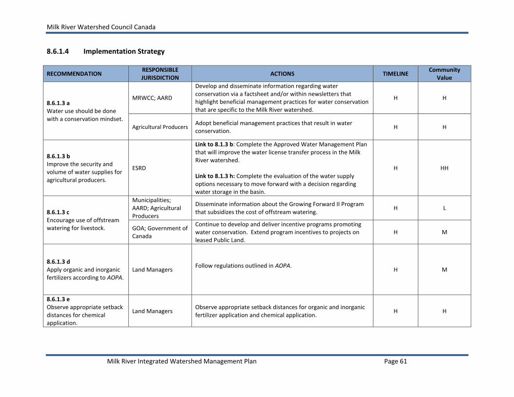
Milk River Watershed Council Canada
Milk River Integrated Watershed Management Plan Page 61
8.6.1.4 Implementation Strategy
RECOMMENDATION RESPONSIBLE JURISDICTION
ACTIONS TIMELINE Community
Value
8.6.1.3 a Water use should be done with a conservation mindset.
MRWCC; AARD
Develop and disseminate information regarding water conservation via a factsheet and/or within newsletters that highlight beneficial management practices for water conservation that are specific to the Milk River watershed.
H H
Agricultural Producers Adopt beneficial management practices that result in water conservation.
H H
8.6.1.3 b Improve the security and volume of water supplies for agricultural producers.
ESRD
Link to 8.1.3 b: Complete the Approved Water Management Plan that will improve the water license transfer process in the Milk River watershed. Link to 8.1.3 h: Complete the evaluation of the water supply options necessary to move forward with a decision regarding water storage in the basin.
H HH
8.6.1.3 c Encourage use of offstream watering for livestock.
Municipalities; AARD; Agricultural Producers
Disseminate information about the Growing Forward II Program that subsidizes the cost of offstream watering.
H L
GOA; Government of Canada
Continue to develop and deliver incentive programs promoting water conservation. Extend program incentives to projects on leased Public Land.
H M
8.6.1.3 d Apply organic and inorganic fertilizers according to AOPA.
Land Managers Follow regulations outlined in AOPA.
H M
8.6.1.3 e Observe appropriate setback distances for chemical application.
Land Managers Observe appropriate setback distances for organic and inorganic fertilizer application and chemical application.
H H

Milk River Watershed Council Canada
Milk River Integrated Watershed Management Plan Page 62
RECOMMENDATION RESPONSIBLE JURISDICTION
ACTIONS TIMELINE Community
Value
8.6.1.3 f BMPs to reduce soil erosion and protect water quality.
Land Managers Implement BMPs that will reduce soil erosion and protect water quality.
H H
8.6.1.3 g Public Lands should remain under grazing disposition.
ESRD (SSRP) Maintain Public Lands under grazing dispositions in the Milk River watershed.
H H
8.6.1.3 h Adopt range management principles.
Land Managers Adopt beneficial range management practices and identify ways to apply them within existing management programs.
H H
8.6.1.3 i Land swaps between Public Land and Private Land
ESRD; Landowners
Identify those private lands within the watershed that provide high conservation value and those that have lower conservation value that are owned publically. Use the existing mechanism to allow for trade between the lower-valued Public Lands and higher-valued Private Lands if private landowners are agreeable, considering parcel size, parcel value, proximity of the private land to other high valued land etc.
M M
8.6.1.3 j Recognize good stewardship and management.
AARD; MRWCC A program should be implemented in the Milk River watershed that recognizes good stewardship and integrated land and resource management.
M M
8.6.1.3 k Prepare an Agriculture Master Plan.
Municipalities Work with agricultural producers within the Milk River watershed to develop an Agriculture Master Plan that will guide agriculture in the area.
L L
H = High Priority, 2014-2016; M = Medium Priority, 2017-2019; L = Low Priority, 2020-2023

Milk River Watershed Council Canada
Milk River Integrated Watershed Management Plan Page 63
8.6.2 INDUSTRIAL AND COMMERCIAL ACTIVITY (OIL AND GAS)
Oil, gas and other resource extraction industries are valued for the contribution they make to the local economy.
Objective 8. Recommend land use and development practices which are consistent with the objectives and resource management strategies for the Milk River watershed and its unique semi-arid environment.
8.6.2.1 Outcomes and Goals
The Milk River watershed provides for oil and gas development while: 1) protecting the economic investment of landowners and leaseholders with respect to
agricultural production and quality of life, and 2) maintaining the ecological, scenic and historic values of this unique landscape.
Goals
Innovative and sustainable land use and development practices take place in the watershed.
A healthy, vibrant economy is present that will attract people and investment to the watershed.
8.6.2.2 Targets and Thresholds
The energy industry should strive to reduce well density, linear fragmentation and overall “footprint” in the Milk River watershed by using innovative approaches to developments and minimal disturbance practices.
8.6.2.3 Recommendations Minimal Disturbance Practices
a) A list of industry Best Management Guidelines on Public Lands is contained in the Alberta Energy Regulator’s Enhanced Approval Process and should be observed when developing oil and gas resources in the Milk River watershed (see Appendix I, Page 106). The recommendations apply a minimum disturbance development philosophy. Implementation of non-oil and gas developments such as surface mineral leases, recreational leases, linear power easements, telecommunication towers and wind development sites should also follow these guidelines and others as appropriate (e.g., BMPs for Wind Development, Foothills Restoration Forum). Industry should extend the minimal disturbance practices, timing restrictions for activity and setbacks for various classes of wetlands currently applied on Public Land to private land. Note: The recommendations do not eliminate the responsibility of developers and resource users to comply with any and all applicable conditions, standards and requirements that are contained in other EAP online documents (e,g., developers must

Milk River Watershed Council Canada
Milk River Integrated Watershed Management Plan Page 64
observe any prescribed industry set back distances or any seasonal timing constraints that may exist).
b) The recommendations found in the GOA’s Enhanced Approval Process (Appendix I, Page
106) are minimum standards. The following revisions should be considered to more accurately support the Milk River watersheds goals regarding riparian areas and wetlands:
Objective 2, Recommendation 2: “Where topography limits the ability to locate roads away from riparian areas, access roads should be located as far from the bed and shore as possible.” (Appendix I, Page 106) Industry should adhere to the recommended riparian setbacks. If applicable setbacks cannot be implemented, industry should work through the non-standard mitigation process provided for in the Enhanced Approval Process non-standard process allowing for place-based decision-making (refer to AER’s D56 application: non-routine technical considerations including public consultations). Objective 2, Recommendation 7: “Culverts can be installed on watercourses provided the following is taken into account: culverts must be maintained and repaired to ensure the integrity of the structure is not compromised, culverts are clearly flagged to identify them and prevent damage by road maintenance activities, culverts must be regularly cleaned to clear blockages of soil/vegetation that might restrict flow.” Revision: Include statement “Prior to construction the proper regulation should be consulted, including the Code of Practice for Watercourse Crossings. Culverts should be properly sized and installed correctly so as not to affect the natural flow of water.”
Water Supply
c) To minimize the risk of on-farm water shortages in times of drought, water for the energy industry should generally be sourced from larger waterbodies rather than local dugouts and ponds, provided that the appropriate Water Act license is obtained (either within an existing municipal or irrigation district license or by temporary diversion license from AER).
d) When feasible, saline (brackish) water, opposed to fresh water, should be used for all drilling activity in the watershed. Although a Water Act license is not required to divert and use saline groundwater (defined as groundwater that has a TDS concentration greater than 4000 mg/L), it is reported to and tracked by the AER under the requirements of Directives 17, 47 and 59.
e) Commercially available, environmentally-friendly products should be used for dust control,
rather than fresh water. Options include lignin tackifiers and other commercial road dust control products.
Groundwater
f) Prior to exploration and/or development activity in the watershed, aquifer vulnerability maps should be consulted by the oil and gas industry and special consideration should be

Milk River Watershed Council Canada
Milk River Integrated Watershed Management Plan Page 65
given to mitigating potential impacts to groundwater, particularly in areas where aquifer vulnerability is rated medium-high and high (refer to Figure 4 for groundwater vulnerability map and Appendix D (Page96) for additional groundwater maps).
g) All potentially affected wells, springs and aquifers should be monitored within a 1.6 km
radius of a well site. In the absence of domestic water wells within the testing radius (1.6 km), the drilling and testing of shallow aquifer monitoring wells may be required prior to any resource development activity occurring to provide a baseline of water quantity and a quality17. For wells drilled horizontally, water levels and water chemistry should be tested along the length of the leg. Note that landowners can make a request to have the well drilled horizontally.
h) Shallow aquifer test monitoring wells should be installed down gradient of oil and gas wells
and impacted domestic water wells for pre-and post- assessment of water quality. Test wells should be monitored for a period of at least 12 months after drilling or seismic has been completed.
i) To protect aquifers, standard practices for drilling operations within the Milk River
watershed should include, but not be limited to the following:
i. Aquifer depths should be determined using available mapping resources and/or consider water well depths within a 1.6 km radius (not the 200 m currently recommended in Directive 8), or the nearest well within the production zone.
ii. Intermediate and additional larger diameter drill casing should be installed to insure against leakage of oil and fluids into the annulus especially during drilling. Intermediate and production casings should be cemented.
iii. Groundwater protective casings should extend a minimum of 25 m below known aquifers (Directive 008, AER 2013) and be completed with full cement return (cement returns to surface) according to Directive 009 (AER 1990).
iv. Well integrity tests should be conducted prior to well completion and Cement Bond Logs should be required to verify the quality of completion.
Reclamation
j) Reclamation activity on private lands and Public Lands should be undertaken by industry18
to achieve site conditions that meet or exceed pre-development site conditions. Site conditions of interest include: vegetation type and density, soil productivity, water quality and quantity, and range productivity. Successful reclamation will result in the progression of natural function of environmental and ecological processes to bring about the eventual restoration of disturbed areas. All dispositions that are linked to activities on Public Lands
17
Current regulations require that all active wells and observation wells are tested within an 800 m radius of
drilling or seismic activity (Directive 056, AER 2011). 18 Reclamation on Public Lands for most industrial activities falls under Alberta’s Environmental Protection and
Enhancement Act administered by AESRD and AER. Land use activities that fall under this Act include: coal operations, mine, pit, borrow, excavation, and peat operations; oil sands and oil sands exploration; railways; sand and gravel operations; telecom tower; transmission lines; upstream oil and gas development.

Milk River Watershed Council Canada
Milk River Integrated Watershed Management Plan Page 66
cannot be cancelled until the development proponent has achieved the required reclamation goals.
Reclamation Certificates should be issued by ESRD on specified land, under the Environmental Protection and Enhancement Act (including linear disturbances) for lands that meet or exceed pre-development site conditions and all current guidelines, including AER guidelines (ESRD 2013a; ESRD 2013b; ESRD 2013c) and provincial recovery strategies for native prairie (Gramineae Consultants Ltd. 2013; Gramineae et al. 2013).
k) On private land, pipeline activity should be included as an activity that requires a
Reclamation Certificate. l) On Public Land, reclamation is mandatory when mineral rights expire. On private land,
reclamation is generally negotiated with landowner as soon as the well is no longer productive. Reclamation Certificates must be issued before payments are terminated with landowners. Greater consideration should be given to the timely reclamation of surface abandonment/ expiration of mineral rights.
m) All companies conducting seismic surveys and developing wells and pipelines on private
lands should have an environmental protection and reclamation plan reviewed by AER. Specifics of weed control, stripping and grading, soil stockpiling, seed mixes used in reclamation, restrictions on drilling in sensitive areas near creeks and wetlands should be included in the plan.
n) Industry contributes to the provincially managed Orphan Well Fund program. AER should
review current practices for using the Orphan Well Fund and improve the system that administers funds to systematically address the reclamation of orphan well sites and pipelines. A mechanism should be in place for industry to access funding to decommission wells, particularly if owners are financially unstable. Sites may be prioritized using a set of criteria that includes risk to environment, risk to landowners/leaseholders, risk to future land use, size, and location. Currently, access to the funds is influenced by landowners on Crown or Private Land and the severity of the disturbance. Note that natural recovery is also desirable in some instances.
Access
o) Because seismic activity occurs on the land surface, landowners are not obligated to provide access to their deeded land. Landowners should negotiate with a company to allow access to land, and identify the conditions under which access is to occur, to conduct seismic surveys.19 Mitigative strategies include seismic surveys when grounds are frozen (i.e., in winter). (no access during muddy conditions, fire risk periods avoided/fire response, gates managed, low disturbance investigations (vibrations vs. drilling holes), seal holes with bentonite)
19
(Refer to “Seismic operations and landowner rights” for more information: http://www1.agric.gov.ab.ca/$department/deptdocs.nsf/all/agdex11511).

Milk River Watershed Council Canada
Milk River Integrated Watershed Management Plan Page 67
p) Open and frequent communication and planning between energy companies and landowners/leaseholders is encouraged. Signed surface lease agreements negotiated between energy companies and landowners for resource drilling and development operations should include, but not be limited to:
- Well and road location and use, - How road and well site will be managed, - How to prevent the spread of weeds, - Flare testing vs. incineration for on-going operations, - Compensation for adverse effects to property values (e.g., loss of acreage, loss of
productivity from setbacks, loss of property value due to loss of viewscapes), and - Reclamation.
Biodiversity
q) All companies conducting oil and/or gas exploration and pipeline transmission development on private land should complete a biodiversity site assessment and submit a Wildlife Habitat and Protection Plan to ESRD for review (Adapted from Cardston County 2009).
r) The spread of invasive plants should be prevented by taking the following precautions:
- Contact local Agricultural Fieldman regarding weed species or crop diseases present in proposed work areas and develop a jobsite plan to ensure minimal disturbance,
- Remain a minimum of 1.6 km from all known prohibited noxious weed patches or areas of crop diseases,
- Equipment should arrive on site in clean condition. s) In areas identified as critical wildlife habitat on private land or Public Lands, horizontal
drilling should be considered to minimize surface disturbance and maintain appropriate buffer between habitat and the production area.
Flaring, Venting and Incineration
t) In the interest of air quality and resource conservation, flaring for reasons other than
emergency or to verify the sulphur content of the well, should not be permitted. Incineration should be used where feasible. All companies should be required to do drill stem testing with closed chamber testing to confirm reserves and measure flow rates. All hydrocarbons should be captured and disposed of in an environmentally safe manner off site. Inline production tests may be considered post-completion.
Education and Awareness
u) The MRWCC and landowners should strive to improve awareness of and develop a better partnership with the oil and gas industry and the Alberta Energy Regulator to better understand and report on industry practices, increase the energy industry’s awareness of local watershed resources and to share in achieving common goals for the watershed.

Milk River Watershed Council Canada
Milk River Integrated Watershed Management Plan Page 68
Research and Monitoring
v) Confirm the age and number of pipelines that cross the Milk River and determine when these were last inspected, by whom, and how frequently inspections occur.
Rationale: There has been one known pipeline failure that exports oil from a tank farm
(SW9 and NW 4-2-16 W4) to Montana. The potential for future failures is unknown. w) At the provincial level, develop a systematic approach to review the risk of a pipeline
failure/incident and develop a proactive preventative process to address incidents. At the very least, a remediation and response plan that takes into consideration the remote nature, unique Milk River watershed conditions, and localized industry best practices should be created.
x) Develop an oil and gas map for the Milk River watershed that includes new and projected
well and pipeline developments. y) Abandoned wells make up 66% of the wells associated with oil and gas activity in the
watershed. Further studies should be undertaken to understand the status and issues associated with abandoned wells.
Rationale: Little is known about the condition of abandoned wells and old wells that are present that may have pre-dated the registration system. There is a potential for aquifer contamination and potential for release of hydrocarbons due to improperly reclaimed wells. Abandoned wells may be re-pressurized creating opportunity for leakage and the potential for localized explosions.
z) Conduct research to better understand the relationship between natural gas extraction and
Milk River groundwater supplies.

Milk River Watershed Council Canada
Milk River Integrated Watershed Management Plan Page 69
8.6.2.4 Implementation Strategy
RECOMMENDATION RESPONSIBLE JURISDICTION
ACTIONS TIMELINE Community
Value
8.6.2.3 a Observe the Enhanced Approval Process Best Management Guide and apply minimum disturbance on public and private lands.
AER; Industry;
Landowners/
Leaseholders
Industry and landowners/leaseholders should be familiar with the EAP process and BMPs that apply minimum disturbance.
H H
8.6.2.3 b Revisions to the EAP.
AER Incorporate the revisions related to culverts into the most recent EAP BMP recommendations
H H
8.6.2.3 c Appropriate water sources for use by industry.
AER Maintain a database of appropriate water sources for the oil and gas industry when working in the Milk River watershed and direct industry to those sources.
H H
Industry Source water from appropriate sources.
8.6.2.3 d Use saline (brackish) water for drilling activity.
Industry When possible, brackish water should be treated and used for drilling activity.
H H
8.6.2.3 e Use commercially available products for dust control rather than fresh water.
Industry Determine most viable option for dust control, other than fresh water.
H H
8.6.2.3 f Consult aquifer vulnerability maps and mitigate potential impacts to groundwater.
MRWCC Update and improve the Milk River aquifer vulnerability map and provide to energy companies.
H
H
Industry Use the aquifer vulnerability map for planning and mitigating potential impacts of oil and gas activity in the Milk River watershed.
H
8.6.2.3 g Monitor potentially affected wells within 1.6 km radius from a well site. A test well may be required.
AER Increase the radius distance for monitoring wells to 1.6 km.
H
H
Industry Use a radius of 1.6 km for monitoring water wells near oil and gas well developments.
H

Milk River Watershed Council Canada
Milk River Integrated Watershed Management Plan Page 70
RECOMMENDATION RESPONSIBLE JURISDICTION
ACTIONS TIMELINE Community
Value
8.6.2.3 h Shallow aquifer test monitoring wells installed and monitored downstream of drilling and local water wells.
AER; Industry Improve water quality monitoring and reporting. Make this information available to the public and incorporate findings in an accessible database.
H H
8.6.2.3 i Groundwater protective casings, completion and Cement Bond Logs.
AER; Industry
Acknowledge the importance of groundwater resources in the Milk River watershed and follow to protect the resources. Adopt new technologies and protocols as they become available.
H H
8.6.2.3 j Reclamation Certificates issued for reclaimed public and private lands that meet or exceed guidelines and recovery strategies.
Industry; Landowners
Reclaimed sites should be inspected by an independent soil scientist, agrologist or other qualified professional. The inspector should then apply for a Reclamation Certificate from ESRD.
H H
8.6.2.3 k Reclamation Certificates should apply to pipeline activity on private land.
Landowners Landowner should identify reclamation concerns for pipelines. sometimes a requirement for natural recovery
H H
8.6.2.3 l Timeliness of reclamation activity.
Industry; Landowners
Industry should review reclamation plans with landowners and leaseholders at the time surface lease agreements are negotiated and again when surface lease rentals are renewed.
H H
AER Develop better guidance to insure the timeliness of reclamation activity.
H H
8.6.2.3 m An Environmental Protection and Reclamation Plan for seismic surveys and wells and pipelines developed on private lands.
AER
Develop a framework to assist private landowners manage impacts of oil and gas activity by establishing a protocol, that may mirror that for Public Land in the province. It may include an Environmental Protection and Reclamation Plan.
H H
8.6.2.3 n Orphan Well Fund.
Orphan Well Association; AER
Review current practices for using the Orphan Well Fund and improve the system that administers funds to systematically address the reclamation of orphan well sites and pipelines.
H H
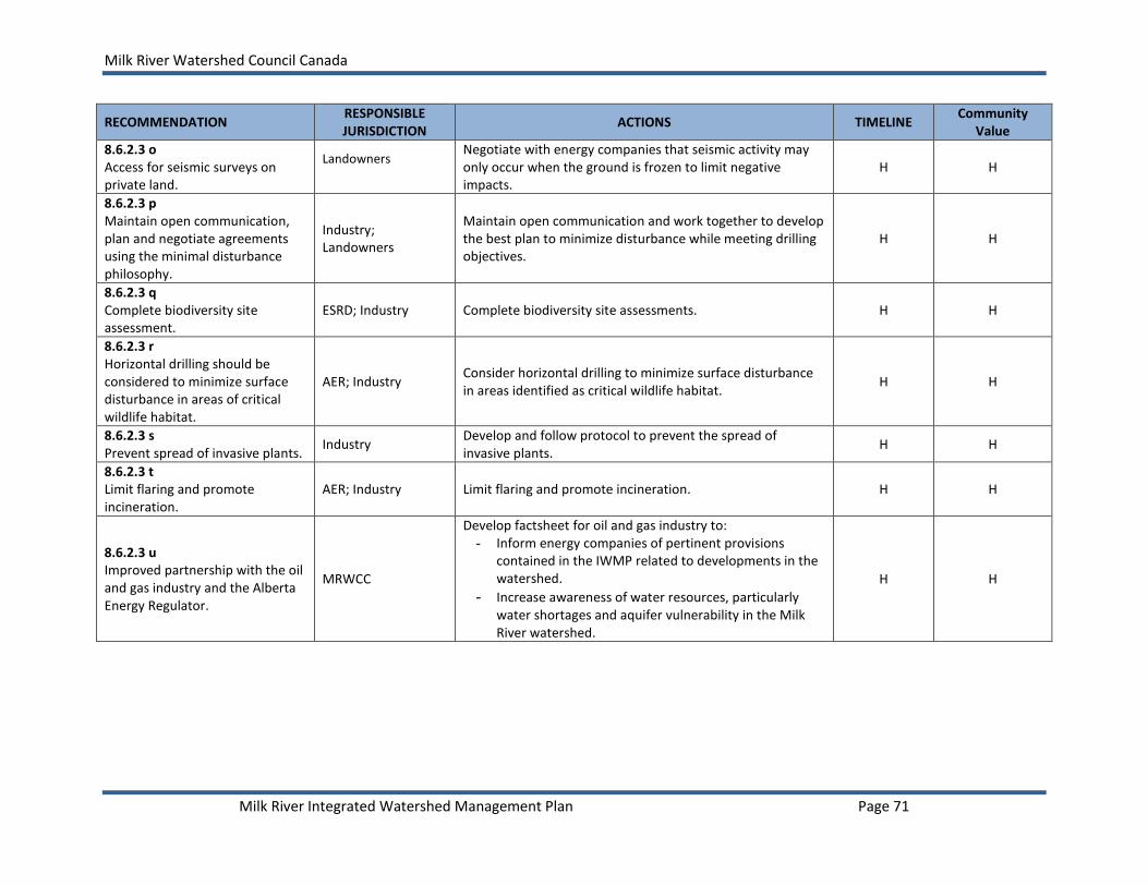
Milk River Watershed Council Canada
Milk River Integrated Watershed Management Plan Page 71
RECOMMENDATION RESPONSIBLE JURISDICTION
ACTIONS TIMELINE Community
Value
8.6.2.3 o Access for seismic surveys on private land.
Landowners Negotiate with energy companies that seismic activity may only occur when the ground is frozen to limit negative impacts.
H H
8.6.2.3 p Maintain open communication, plan and negotiate agreements using the minimal disturbance philosophy.
Industry; Landowners
Maintain open communication and work together to develop the best plan to minimize disturbance while meeting drilling objectives.
H H
8.6.2.3 q Complete biodiversity site assessment.
ESRD; Industry Complete biodiversity site assessments. H H
8.6.2.3 r Horizontal drilling should be considered to minimize surface disturbance in areas of critical wildlife habitat.
AER; Industry Consider horizontal drilling to minimize surface disturbance in areas identified as critical wildlife habitat.
H H
8.6.2.3 s Prevent spread of invasive plants.
Industry Develop and follow protocol to prevent the spread of invasive plants.
H H
8.6.2.3 t Limit flaring and promote incineration.
AER; Industry Limit flaring and promote incineration. H H
8.6.2.3 u Improved partnership with the oil and gas industry and the Alberta Energy Regulator.
MRWCC
Develop factsheet for oil and gas industry to: - Inform energy companies of pertinent provisions
contained in the IWMP related to developments in the watershed.
- Increase awareness of water resources, particularly water shortages and aquifer vulnerability in the Milk River watershed.
H H

Milk River Watershed Council Canada
Milk River Integrated Watershed Management Plan Page 72
RECOMMENDATION RESPONSIBLE JURISDICTION
ACTIONS TIMELINE Community
Value
MRWCC; AER; Industry
Work together to better disseminate resource material for public that addresses some of the local concerns regarding oil and gas industry activity, including, but not limited to:
- Extension of surface conductive casings beyond the minimum requirements outlined in Directive 8 (AER) to a minimum of 25 m below known aquifer depths
- The oil and water separation process and risks to surface water and groundwater quality
- Disposal of waste water associated with drilling operations
- Emergency response plans in place in the event of a sour gas leak according to Directive 071 (AER). Emergency plans must be communicated to landowners and communities so they understand how a sour gas leak is communicated, and how evacuations will occur.
H H
8.6.2.3 v Verify the age and number of pipelines crossing the Milk River.
MRWCC
Review data provided by the Alberta Energy Regulator and prepare a report to share with the Milk River community and stakeholders. Actions should be recommended to upgrade old infrastructure to present-day standards and water body crossing criteria (e.g., deeper depth) to protect surface and groundwater quality.
H H
8.6.2.3 w At the provincial level, review the risk of pipeline failure/incident; develop a proactive preventative process to address incidents.
AER; ESRD Complete a review of pipeline failures/incidents and report the risk to the public. Develop a proactive preventative process to address incidents.
M H
8.6.2.3 x Update the oil and gas map for the Milk River watershed.
AER; Industry; MRWCC
Work to update and maintain an oil and gas well and pipeline map for the watershed in Alberta. Review map to identify potential impacts and explore opportunities to work with industry on planning and development. MRWCC should assist to facilitate discussions.
M H

Milk River Watershed Council Canada
Milk River Integrated Watershed Management Plan Page 73
RECOMMENDATION RESPONSIBLE JURISDICTION
ACTIONS TIMELINE Community
Value
8.6.2.3 y Studies should be undertaken to understand the status of abandoned wells.
AER (lead); Industry; Municipalities; Landowners; MRWCC
Work together to understand the status and impacts of abandoned wells associated with the oil and gas industry.
M H
8.6.2.3 z Research the relationship between natural gas extraction and Milk River groundwater supplies.
ESRD (lead); Geological Survey of Canada; Universities
Work together to build on work completed within the Milk River Transboundary Aquifer Project to investigate the relationship between natural gas extraction and groundwater supplies in the watershed.
M H
H = High Priority, 2014-2016; M = Medium Priority, 2017-2019; L = Low Priority, 2020-2023
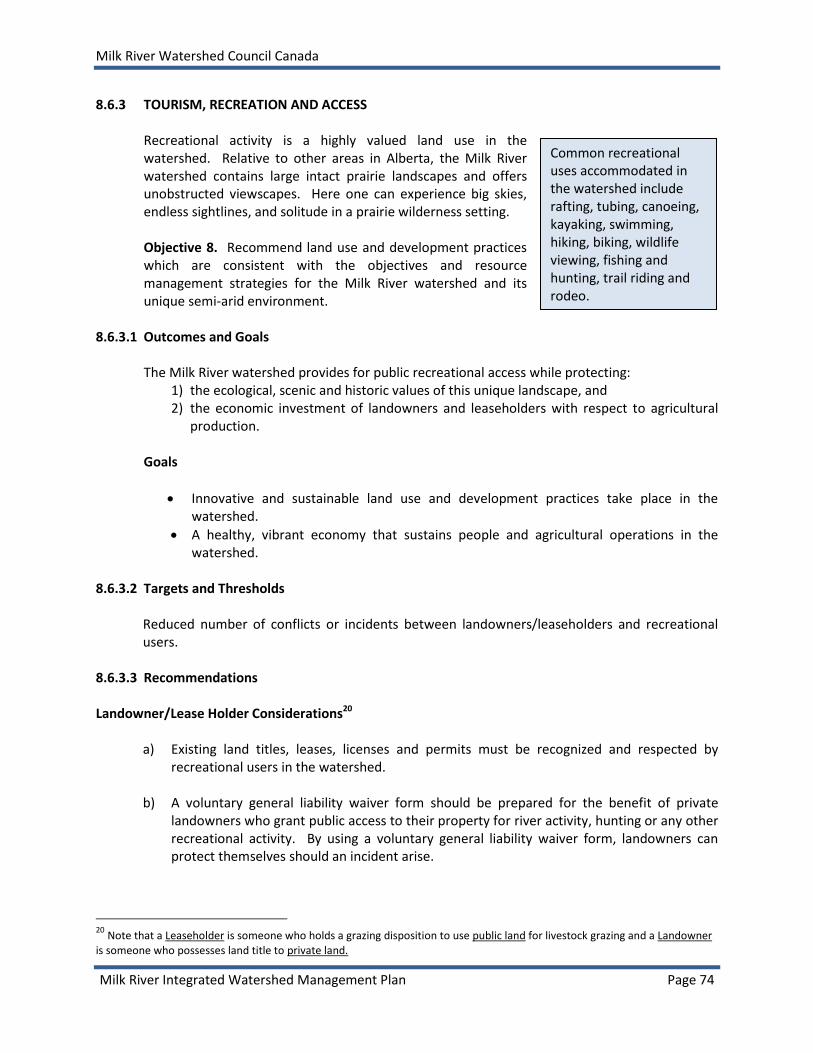
Milk River Watershed Council Canada
Milk River Integrated Watershed Management Plan Page 74
8.6.3 TOURISM, RECREATION AND ACCESS
Recreational activity is a highly valued land use in the watershed. Relative to other areas in Alberta, the Milk River watershed contains large intact prairie landscapes and offers unobstructed viewscapes. Here one can experience big skies, endless sightlines, and solitude in a prairie wilderness setting. Objective 8. Recommend land use and development practices which are consistent with the objectives and resource management strategies for the Milk River watershed and its unique semi-arid environment.
8.6.3.1 Outcomes and Goals
The Milk River watershed provides for public recreational access while protecting: 1) the ecological, scenic and historic values of this unique landscape, and 2) the economic investment of landowners and leaseholders with respect to agricultural
production. Goals
Innovative and sustainable land use and development practices take place in the watershed.
A healthy, vibrant economy that sustains people and agricultural operations in the watershed.
8.6.3.2 Targets and Thresholds
Reduced number of conflicts or incidents between landowners/leaseholders and recreational users.
8.6.3.3 Recommendations Landowner/Lease Holder Considerations20
a) Existing land titles, leases, licenses and permits must be recognized and respected by recreational users in the watershed.
b) A voluntary general liability waiver form should be prepared for the benefit of private landowners who grant public access to their property for river activity, hunting or any other recreational activity. By using a voluntary general liability waiver form, landowners can protect themselves should an incident arise.
20
Note that a Leaseholder is someone who holds a grazing disposition to use public land for livestock grazing and a Landowner is someone who possesses land title to private land.
Common recreational uses accommodated in the watershed include rafting, tubing, canoeing, kayaking, swimming, hiking, biking, wildlife viewing, fishing and hunting, trail riding and rodeo.

Milk River Watershed Council Canada
Milk River Integrated Watershed Management Plan Page 75
Access and Road Allowances
c) Improvements (e.g., infrastructure upgrades, improved accessibility) should be considered to encourage use of existing access sites. Additional river access points may be considered in the future.
d) Standardize road allowance public use policies and bylaws among rural municipalities in the watershed to provide clear and common information for river users, as well as map available road allowance access points to the Milk River.21
e) Identify areas in the watershed where access via road allowance is a concern. f) Clearly sign road allowances that are available for public access. g) Clearly mark private roads with “no river access” signage where trespassing is a concern.
Camping
h) Investigate the viability of increasing the number of designated overnight camping sites adjacent to or in the vicinity of the Milk River to reduce the occurrence of random camping in the watershed.
i) Develop maps for areas in the watershed where overnight camping is allowed. The map should differentiate among areas where permits are required to camp, where permits are not required and where camping is prohibited to reduce trespassing concerns and safety concerns such as fire.
Public Awareness and Education
j) Develop and disseminate educational information to river users and the public to increase understanding of:
I. Water Management
water flows and water quality advisories
II. General User Responsibilities
general ethics
fire
wildlife
traditional landuse/ranching
21 Currently municipalities in the watershed have different guidelines they use to determine access to right-of-ways. In Cypress County, for example, some road allowances are rented, some are not marked and some are assumed to be a part of the landowner’s parcel of land. There are some “graded trails” or “goat trails” that are fenced on each side that can be easily travelled in dry conditions. Each case needs to be assessed individually. If access onto a road allowance is needed and it appears that it is not meant to be accessible to the public (a closed gate, not much traffic) the adjacent landowner should be contacted for information. In the County of Warner, all developed road allowances are accessible to the public and it is unlawful to obstruct access by way of blocking the road allowance or putting up a gate. However, the County allows farmers to carry out farming activities on undeveloped road allowances.

Milk River Watershed Council Canada
Milk River Integrated Watershed Management Plan Page 76
parking
Invasive species III. Health and Safety
fire hazard
wildlife (e.g., rattlesnakes and scorpions)
river hazards
health and safety risks
IV. Access
what Public Land is, where it is located, and how to seek permission to access Public Land in the Milk River watershed22
definition of bed and shore and user responsibilities
an information link for access information and contacts for ACA/NCC properties along the river
access to private agricultural lands
crossing the international border
other details as identified k) Create a detailed area map that clearly identifies designated access points, river distances
and timing, camping sites, shelter facilities, potable water availability, wash room facilities, and other features.
l) Create on-site, property access maps that include a description of general “Rules of the
River and Ethics” (e.g., fires, garbage) as well as property specific considerations such as parking, restricted areas, and other special considerations for use by landowners and leaseholders who voluntarily provide access.
m) Establish a Voluntary River Use Registration Program for extended/multi-day user trips to
register with local authorities and/or Writing-on-Stone Provincial Park prior to departure and follow-up check in when complete to reduce the potential for un-prepared users and potential of burden on emergency services.
Protection of Archeological, Historical and Cultural Artifacts
n) Increase awareness regarding restrictions to access, and penalty for vandalism and
disruption of significant historic resources (i.e., any work of nature or of humans that is primarily of value for its paleontological, archaeological, prehistoric, historic, cultural, natural, scientific or aesthetic interest (ATPRC 2007)) along the river ($50,000.00 fine or 2 years in jail) using a variety of communication methods (e.g., improve signage, website, factsheets).
22
Recreational users need permission from the grazing disposition holder, in accordance with the Public Lands Recreational
Access Regulation, before travelling on Public Lands under a grazing disposition. See Appendix XX for a brochure that contains essential information on accessing public land under a grazing lease. A new, online tool “Recreational Access to Agricultural Public Land Contact and Access Condition Information” was made available on January 2014 and is found at https://maps.srd.alberta.ca/RecAccess/default.aspx?Viewer=RecAccess .

Milk River Watershed Council Canada
Milk River Integrated Watershed Management Plan Page 77
8.6.3.4 Implementation Strategy
RECOMMENDATION RESPONSIBLE JURISDICTION
ACTIONS TIMELINE COMMUNITY
VALUE
8.6.3.3 a Recreational users and public recognize existing land titles, leases, licenses and permits.
Public Recognize existing land titles, leases, licenses and permits when travelling, working or recreating in the Milk River watershed.
H H
8.6.3.3 b Voluntary General Liability waiver form provided to landowners/leaseholders.
Municipalities; Southern Alberta Outdoorsmen; Alberta Fish and Game Association; MRWCC
The feasibility, liability and logistics of a Voluntary General Liability waiver form should be explored.
M-H H
8.6.3.3 c Consider improvements to existing river access sites to encourage use.
MRWCC; ATPR; Municipalities
Develop a map showing all “open” river access points, road and trails as of December 2012. Discuss potential for improvements to river access and develop an improvement plan.
M M
8.6.3.3 d Standardize road allowance public access policies and bylaws among rural municipalities.
MRWCC; Municipalities
MRWCC should facilitate a meeting with municipalities and select landowners to identify areas in the watershed where access is a concern and to discuss how road allowance policies differ among jurisdictions. Discussion should include if and how road allowance policies could be standardized in the watershed.
L-M
L
8.6.3.3 e Identify areas in the watershed where access via road allowance is a concern.
L
8.6.3.3 f Clearly mark road allowances that have river access.
Municipalities
Municipality should post information on websites that specifies the responsibility of individuals when accessing the river and to identify public river access on a map. “River Access” signs should be made available at municipal offices for landowners to set up and maintain.
L-M M
8.6.3.3 g Clearly mark private roads with “no river access” signs.
Landowners Landowners should mark private roads with “No River Access” to avoid potential conflicts where access is an issue.
L-M H

Milk River Watershed Council Canada
Milk River Integrated Watershed Management Plan Page 78
RECOMMENDATION RESPONSIBLE JURISDICTION
ACTIONS TIMELINE COMMUNITY
VALUE
8.6.3.3 h Investigate the viability of increasing the availability of overnight camping sites.
Writing-on-Stone Provincial Park; Gold Springs Park; Del Bonita Campground; Town of Milk River; Private
Identify potential areas where opportunities for camping exist. Discuss opportunities with the Milk River community.
M-H M-H
8.6.3.3 i Develop maps for areas in the watershed where overnight camping is allowed (include where permits are required, not required or where camping is prohibited.
MRWCC; ATPR
MRWCC to facilitate discussions with ATPR to create a map showing camping opportunities in the Milk River. This map should be included with communication and outreach material.
M-H M
8.6.3.3 j Develop and disseminate educational information to river users and public.
MRWCC; ESRD; ACA; NCC; Canadian Badlands Association, Palliser Economic Partnership, Economic Development Alliance
Disseminate St. Mary River diversion start-up date and closure dates as well as river advisory information to MRWCC membership and contacts. Provide a link on the MRWCC website to up-to-date advisories as well as river flow information. Develop clear statements on water and land use and responsibility of users. Place information and key messages on access signage and mapping products. Develop information resource that provides access information and contacts for Public Land, properties owned by NGOs and for private lands along the river.
Communication methods include: - Enhanced river signage for value and significance of the
local landscape - Milk River Watershed Brochure (include access
information, user responsibilities, recreational watershed map)
- Enhanced access signage and access maps highlighting key messages
- Social media tools (e.g., Facebook)
M-H H

Milk River Watershed Council Canada
Milk River Integrated Watershed Management Plan Page 79
RECOMMENDATION RESPONSIBLE JURISDICTION
ACTIONS TIMELINE COMMUNITY
VALUE
8.6.3.3 k Create a detailed area map. Municipalities; Alberta
Fish and Game Association; Southern Alberta Outdoorsmen; MRWCC
Include additional information such as how to obtain permission to access private land and leased land, parking, registration (for walking access and/or overnight camping) if required and historical resources. Information may be tailored for various user groups. Provide link to website that houses the contacts and guide to access Public Land.
M
H
8.6.3.3 l Create onsite property access maps.
H
8.6.3.3 m Establish a Voluntary River Use Registration Program.
ATPR (WOSPP) Establish a Voluntary River Use Registration Program. H H
8.6.3.3 n Clearly define restrictions to access, and penalty for vandalism and disruption of significant historical sites along the river.
ATPR Disseminate information to public and other non-profit organizations within the watershed to increase awareness regarding heritage protection and penalties for vandalism.
H H
H = High Priority, 2014-2016; M = Medium Priority, 2017-2019; L = Low Priority, 2020-2023

Milk River Watershed Council Canada
Milk River Integrated Watershed Management Plan Page 80
9.0 ECONOMY
Objective 9: Recommend strategies to maintain and improve the economic condition within the Milk River watershed.
9.1 Outcomes and Goal
A healthy, vibrant economy that sustains the community and the agricultural, industrial and tourism sectors in the watershed. Goals To promote economic growth and diversification that is beneficial to the regional community and province.
9.2 Targets and Thresholds
Population in the Milk River watershed is maintained and/or increases through time. Local businesses, services and public facilities (e.g., schools, hospital, recreation centers) are available to support the community and provide employment opportunity. Growth in per capita income increases.
Note: Statistics Canada ratings may be used to report on economic indicators for the Milk River watershed, including: employment, income, economic output and population.
9.3 Recommendations
a) The differences between rural and urban areas should be recognized and accounted for within provincial planning initiatives; regulations that are suited to more populated and high growth-rate urban regions may not be applicable or suitable within rural municipalities (in this regard it should be noted that the Milk River basin is unique within the province of Alberta in terms of its landscape, geography, population and infrastructure. This requires that planning and policy solutions be suited to this distinctive region)
b) There should be no further provincial downloading of responsibility to municipalities,
landowners and licensees, resulting from changing provincial regulations or policy initiatives and that full financial support should be provided to implement projects and programs that result from these regulations, particularly when the projects show little or no added benefit to rural residents .
c) Concerted action should be taken to increase water supply capacity within the watershed
that will support community prosperity and well-being.

Milk River Watershed Council Canada
Milk River Integrated Watershed Management Plan Page 81
d) Adopt population retention initiatives in the Milk River watershed by exploring new ways to employ basin residents in the following priority sectors: agriculture, tourism, energy and other local businesses and service industries.
e) Investigate the potential for increased promotion and development of sustainable
economic activity in the watershed related to Bed and Breakfasts, eco-tourism (more commercial operators on the river, tourism destination areas) and other support/service businesses (accommodation) for recreation.
f) Unique economic attributes in the watershed should be identified and used to develop a
sustainable agricultural growth strategy (as part of a Master Plan). Opportunities that exist include: use of existing available surface water, unique agri-climatic features, (i.e., a soil and climate suitable for specialized crop and livestock production), close proximity to United States markets, and the strategic location serviced by Alberta-Montana Highway 4 and the CP railway.
Natural Capital
Maintaining biodiversity within the Milk River watershed comes with a cost to landowners, leaseholders and industry. Natural capital refers to the sum of all resources and services provided by nature. The benefits of healthy, functioning ecosystems are often unaccounted for in traditional economics, but they are essential to our quality of life, now and in the future. Ecosystem services can be managed and maintained concurrently with agricultural activity on rangeland and cropland, however there is a cost to landowners and leaseholders that is often left unaccounted. Examples of services maintained by the agricultural industry include the maintenance of quality habitat for wildlife, the groundwater recharge function of wetlands, and aesthetically-pleasing landscapes/viewscapes. Assess the monetary value of natural capital in the Milk River watershed to inform an incentive program that could be offered to landowners.
g) Explore incentives for maintaining Alberta’s natural capital on private land in the Milk River
watershed. i. Investigate the feasibility and implications of applying the Stewardship Credit
Program model (which has been adopted at the Nature Conservancy of Canada’s Sandstone Ranch in the Milk River watershed) to other lands in the basin.
h) Promote beneficial management practices that could be voluntarily adopted by land
stewards to increase the value of the Milk River watershed’s natural capital on private lands.
i) Assess the impact of the Alberta Land Stewardship Act and the South Saskatchewan
Regional Plan on the social and economic conditions in the Milk River watershed.

Milk River Watershed Council Canada
Milk River Integrated Watershed Management Plan Page 82
9.4 Implementation Strategy
RECOMMENDATION RESPONSIBLE JURISDICTION
ACTIONS TIMELINE COMMUNITY
VALUE
9.3 a Recognize and account for differences in urban and rural areas in planning initiatives.
GOA Recognize the unique social, economic and environment conditions in the Milk River watershed (as part of the Missouri River drainage) compared to the rest of the South Saskatchewan planning region.
H H
9.3 b No further downloading resulting from changing provincial regulations/policy.
GOA Limit downloading of responsibilities to municipalities that do not have the resources to implement recommended (sometimes regulated) actions. Consider the economic implications of decisions.
H H
9.3 c Concerted effort to improve water supply capacity in the watershed.
GOA
Complete relevant investigations required to evaluate and determine the most viable water supply option. Consult with community regarding the findings of the investigations.
H H-H
Municipalities Inform elected officials of intent to advance the water supply initiatives.
MRWCC
Compile existing studies pertaining to water supply investigations on the Milk River. Disseminate summary information to basin residents, landowners, municipalities. Confirm community support for water supply alternatives.
9.3 d Develop strategy to retain population.
Municipalities; Palliser Economic Partnership; Economic Development Alliance
The plan should be developed in collaboration and include strategies to: - Maintain and secure essential services in the Town of Milk River
(i.e., hospital, schools). - Secure water supplies to support economic growth and reduce
economic risk and uncertainty.
M H

Milk River Watershed Council Canada
Milk River Integrated Watershed Management Plan Page 83
RECOMMENDATION RESPONSIBLE JURISDICTION
ACTIONS TIMELINE COMMUNITY
VALUE
9.3 e Investigate the potential for sustainable economic growth in the watershed.
Municipalities; Canadian Badlands Association, Palliser Economic Partnership, Economic Development Alliance; Milk River Community Business Association
Work with local and regional groups focused on economic development to produce a growth strategy within the region of the Milk River watershed.
M H
9.3 f Identify unique economic attributes in the watershed; develop a sustainable agricultural growth strategy (as part of a Master Plan).
Municipalities; AARD
Identify unique economic attributes in the watershed to enhance agricultural opportunities. Forecast the economic growth and opportunity that results when secure water supplies in the watershed are realized.
M H

Milk River Watershed Council Canada
Milk River Integrated Watershed Management Plan Page 84
RECOMMENDATION RESPONSIBLE JURISDICTION
ACTIONS TIMELINE COMMUNITY
VALUE
9.3 g Assess the monetary value of natural capital in the Milk River watershed.
MRWCC
Assess the value of natural capital on Public and private lands in the watershed. Develop an Ecological Goods and Services payment program that is relevant to the Milk River watershed. For Public and private lands, consider payments to landowners to maintain:
- Critical habitat (i.e., Silver Sagebrush, wetlands; hibernacula) - Contiguous area maintained in native grassland - Unique vegetation (i.e., blue flag iris; Yucca) - Shrub communities - Tree communities
Payments to landowners to be based on area of ecologically functional landscapes and the condition of these landscapes (i.e., health status). Consider assistance with capital cost of management practices:
- Riparian pasture fencing and offstream watering systems - Pronghorn friendly fencing - Weed control
M H 9.3 h Explore incentives for maintaining Alberta’s natural capital on private land.
9.3 i Promote BMPs that could be voluntarily adopted by land stewards to increase natural capital value on private lands.
ACA; MultiSAR; NCC; Municipalities; MRWCC
Continue to promote BMPs within the Milk River watershed. M M
9.3 j Assess the impact of the Alberta Land Stewardship Act on the social and economic conditions in the watershed.
Municipalities; Property Rights Advocate
Assess the impact of the Alberta Land Stewardship Act and clearly identify how these impacts can be mitigated. Forward concerns regarding ALSA to the review committee charged with amending the Act.
M M
H = High Priority, 2014-2016; M = Medium Priority, 2017-2019; L = Low Priority, 2020-2023

Milk River Watershed Council Canada
Milk River Integrated Watershed Management Plan Page 85
10.0 SCHEDULE
TIMELINE ACTION
2014
Seek endorsement from MRWCC Membership and Municipalities. Seek support from Provincial Government.
The MRWCC will develop a work plan that will identify the lead organization and the process that will be used to define how implementation actions will be accomplished, including plan amendments and review intervals.
Fund development
2014-2016
Implementation of High Priority Items Fund development. Review progress and produce annual implementation report summary for community, municipalities, provincial government, NGOs and public.
2017-19
Implementation of Medium Priority Items Fund development. Review progress and produce annual implementation report summary for community, municipalities, provincial government, NGOs and public.
2020-2023 Implementation of Low Priority Items. Fund development
11.0 LIST OF ACRONYMS
AARD Alberta Agriculture and Rural Development ACA Alberta Conservation Association AESRD Alberta Environment and Sustainable Resource Development AER Alberta Energy Regulator AEMERA Alberta Environmental Monitoring, Evaluation and Reporting Agency AOPA Agricultural Operations Practices Act ASB Agricultural Service Board ATPR Alberta Tourism, Parks and Recreation AWMP Approved Water Management Plan BMP Beneficial Management Practice DFO Fisheries and Oceans Canada EAP Enhanced Approval Process ESRD Alberta Environment and Sustainable Resource Development GOA Government of Alberta IWMP Integrated Watershed Management Plan MRWCC Milk River Watershed Council Canada MT Montana MULTISAR Multiple Species at Risk NCC Nature Conservancy of Canada NGO Non-Government Organization SOW State of the Watershed SSRP South Saskatchewan Regional Plan WOSPP Writing-on-Stone Provincial Park WCO Water Conservation Objective WQO Water Quality Objective

Milk River Watershed Council Canada
Milk River Integrated Watershed Management Plan Page 86
12.0 BIBLIOGRAPHY
12.1 Literature Cited Adams, B.W., R. Ehlert, D. Moisey and R.L McNeil. 2003. Rangeland Plant Communities and Range
Health Guidelines for the Foothills Fescue Natural Subregion of Alberta. Rangeland Management Branch, Public Lands Division, Alberta Sustainable Resource Development, Lethbridge, AB. Pub. No. T/038.85 pp.
Adams, B.W., J. Carlson, D.Milner, T. Hood, B.Cairns, and P. Herzog. 2004. Beneficial Grazing
Management Practices for Sage Grouse (Centrocercus urophasianus) and ecology of silver sage brush (Artemisia cana) in Southeastern Alberta. Technical Report, Public Lands and Forests Division, Alberta Sustainable Resource Development, Pub. No. T/049. 60 pp.
Adams, B.W., Poulin-Klein, L., Moisey, D., and McNeil, R.L. 2005a. Range plant communities and range
health assessment guidelines for the Dry Mixed Grass natural subregion of Alberta. Pub. No. T/040, Alberta Sustainable Resource Development, Rangeland Management Branch, Public Lands and Forests Division, Lethbridge, 106p.
Adams, B.W., Poulin-Klein, L., Moisey, D., and McNeil, R.L. 2005b. Range plant communities and range health assessment guidelines for the Mixed Grass natural subregion of Alberta. Pub. No. T/039, Alberta Sustainable Resource Development, Rangeland Management Branch, Public Lands and Forests Division, Lethbridge, 101p.
Alberta Agriculture, Food and Rural Development (AARD) and Agriculture and Agri-Food Canada (AAFC).
2004. Beneficial Management Practices: Environmental Manual for Crop Producers in Alberta. Agriculture, Food and Rural Development, Edmonton, Alberta. 157 pp.
Alberta Environment and Sustainable Resource Development (ESRD). 2013a. 2010 Reclamation Criteria
for Wellsites and Associated Facilities for Cultivated Lands (Updated July 2013). Edmonton, Alberta. 92 pp.
Alberta Environment and Sustainable Resource Development (ESRD). 2013b. 2010 Reclamation Criteria
for Wellsites and Associated Facilities for Native Grasslands (July 2013 Update). Edmonton, Alberta. 92 pp.
Alberta Environment and Sustainable Resource Development (ESRD). 2013c. 2010 Reclamation Criteria
for Wellsites and Associated Facilities for Forested Lands (Updated July 2013). Edmonton, Alberta. 81 pp.
Alberta Ferruginous Hawk Recovery Team. 2009. Alberta Ferruginous Hawk Recovery Plan 2009-2014.
Alberta Sustainable Resource Development, Fish and Wildlife Division, Alberta Recovery Plan No. 17, Edmonton, AB. 44pp.
Alberta Environment and Sustainable Resource Development (ESRD). 2011. Recommended Land Use
Guidelines for Protection of Selected Wildlife Species and Habitat within Grassland and Parkland Natural Regions of Alberta. Fish and Wildlife Division. 5 pp.

Milk River Watershed Council Canada
Milk River Integrated Watershed Management Plan Page 87
Alberta Fish and Wildlife Division. 1990. Management Plan for Pronghorn Antelope in Alberta. Forestry and Lands Fish and Wildlife Division. Pp 115.
Alberta Sustainable Resource Development. 2007. Grazing Lease Stewardship Code of Practice. Alberta
Sustainable Resource Development, Edmonton, Alberta. 14 pp. Alberta Sage Grouse Recovery Action Group. 2005. Alberta Greater Sage-Grouse Recovery Plan. Alberta
Sustainable Resource Development, Fish and Wildlife Division, Alberta Species at Risk Recovery Plan No. 8. Edmonton, AB. 33 pp.
Alberta Sustainable Resource Development. 2003. About Public Lands: Information on Grazing
Statistics. Alberta Sustainable Resource Development, Lands Division. Edmonton, Alberta. 2 pp. Armantrout, N.B., compiler. 1998. Glossary of aquatic habitat inventory terminology. American
Fisheries Society, Bethseda, Maryland. 136 pp. Campbell, K. and T. Howard. 2004. When the Landman Comes Knocking. A Handbook for BC
Landowners Living with Oil and Gas.West Coast Environmental Law and Sierra Legal Defence Fund, Vancouver, BC.24 pp.
Cardston County. 2009. The Cardston County Protocol for Seismic Surveying, Drilling, Construction and
Operation of Oil and Gas Facilities in Cardston County. Cardston, AB. 20 pp. Golder Associates. 2004. Report on Development of a Management/Protection Plan for the Whisky
Valley Aquifer, County of Warner, Alberta. Milk River West Water User’s Co-op, Milk River, AB. 72 pp. + Appendices.
Government of Alberta. 2008. Reference Guide to the Agricultural Operations Practices Act (AOPA).
Queen’s Printer for Alberta. 11 pp. Gramineae Consultants Ltd. 2013. Recovery Strategies for Industrial Development in Native Prairie for
the Dry Mixedgrass Natural Subregion of Alberta. Prepared for Alberta Environment and Sustainable Resource Development, Range Resource Management Program, Lands Division. 134 pp.
Gramineae Consultants Ltd., Kestrel Research Inc. and Desserud Environmental Ltd. 2013 (Draft).
Recovery Strategies for Industrial Development in Native Prairie for the Mixedgrass Natural Subregion of Alberta. Prepared for Alberta Environment and Sustainable Resource Development, Range Resource Management Program, Lands Division and Petroleum Technology Alliance Canada. 164 pp.
Green, M., R. Quinlan, P. Jones, L. Allen, L. Cerney, R. Bennett, B. Moffet, T. Lee Ndugga and D. Watson.
Alberta Milk River Conservation Site Plan. 2004. In Smith Fargey, K. (ed.), Shared Prairie - Shared Vision: The Northern Mixed Grass Transboundary Conservation Initiative. Conservation Site Planning Workshop Proceedings and Digital Atlas. Regina, Saskatchewan: Canadian Wildlife Service, Environment Canada.

Milk River Watershed Council Canada
Milk River Integrated Watershed Management Plan Page 88
Michalsky, S., J. Nicholson, D. Blouin, D. Arneson, L. Veitch, J. Landry, J. Peters, S. McAdam, G. Trottier and P. Erickson. Sage Creek -Southwest Pasture Complex Conservation Site Plan. 2004. In Smith Fargey, K. (ed.), Shared Prairie - Shared Vision: The Northern Mixed Grass Transboundary Conservation Initiative. Conservation Site Planning Workshop Proceedings and Digital Atlas. Regina, Saskatchewan: Canadian Wildlife Service, Environment Canada.
Migaj. A., C. M. Kemper, B.L. Downey, 2011. Ferruginous hawk artificial nest poles: inventory and
construction protocol. Alberta Sustainable Resource Development, Fish and Wildlife Division, Alberta Species at Risk Report No. 140, Edmonton, AB. 22 pp.
Nicholson, J. and S.L. Rose. 2001. Utilization of sire photo interpretation to locate prairie rattlesnake
(Crotalus viridis viridis) hibernacula in the south Saskatchewan River Valley. Alberta Sustainable Resource Development, Fisheries and Wildlife Division. Alberta Species at Risk Report No. 22. Edmonton, Alberta.
OECD (1994) Environmental Indicators: OECD Core Set, Paris. Paige, C. 2008. A Landowner’s Guide to Wildlife Friendly Fences. Landowner/Wildlife Resource Program,
Montana Fish, Wildlife and Parks, Helena, MT. 44 pp. Palliser Environmental Services Ltd. (PESL). 2012. Jumpingpound Creek Integrated Watershed
Management Plan. Prepared for the Jumpingpound Creek Watershed Partnership, Cochrane, AB.
Rangeland Conservation Service Ltd. 2004. Beneficial Management Practices for the Milk River Basin,
Alberta: A component of the Multi-Species Conservation Strategy for Species At Risk in the Milk River Basin (MULTISAR). Unpublished report prepared for Alberta Sustainable, Resource Development, Fish and Wildlife Division and the Alberta Conservation Association. Airdrie, Alberta. 369 pp.
Salmo Consulting Inc. 2006. Developing and Implementing Thresholds in the Northwest Territories- A
Discussion Paper. Yellowknife: Prepared for: Environment Canada, Northern Division. Watson, S.M. and A.P. Russell. 1997. Status of the prairie rattlesnake (Crotalus viridis viridis) in Alberta.
Alberta Environmental Protection, Wildlife Management Division, Wildlife Status Report No. 6. Edmonton, Alberta. 26 pp.
Willoughby, M.G., M. Alexander and B.W. Adams. 2005. Range Plant Community Types and Carrying
Capacity for the Montane Subregion. Sixth Approximation. Alberta Sustainable Resource Development, Public Lands and Forests Division, Edmonton, Alberta. 235 pp.

Milk River Watershed Council Canada
Milk River Integrated Watershed Management Plan Page 89
12.2 Map Information Figure 1 (Page 7) Alberta data: Base Data provided by Spatial Data Warehouse Ltd. Montana data:
Road network provided by Montana Dept. of Transportation / Planning / Data & Statistics Bureau / RIM. Municipalities provided by Montana Base Map Service Center, Department of Administration, Information Technology Services Division. Hydrography provided by USGS National Hydrography Dataset / USDA NRCS Watershed Boundary Dataset. Managed Areas (Land Ownership ) provided by Montana Natural Heritage Program. Saskatchewan data: Roads (National Road Network) and Hydrography © Department of Natural Resources Canada. All rights reserved. Urban Places provided by Saskatchewan Research Council. Parks and protected areas provided by Saskatchewan Ministry of Environment, sourced: Her Majesty The Queen in Right of Saskatchewan, Land Ownership. First Nations Reserves provided by Information Services Corporation of Saskatchewan. Milk River Basin boundary provided by U.S. Geological Survey (USGS), National Hydrography Dataset / U.S. Department of Agriculture (USDA), Natural Resources Conservation Service (NRCS) Watershed Boundary Dataset. Produced by Alberta Environment and Sustainable Resource Development, South Saskatchewan Region, Regional Informatics Unit, Lethbridge, May 2014. The Minister and the Crown provides this information without warranty or representation as to any matter including but not limited to whether the data / information is correct, accurate or free from error, defect, danger, or hazard and whether it is otherwise useful or suitable for any use the user may make of it. © 2014 Government of Alberta.
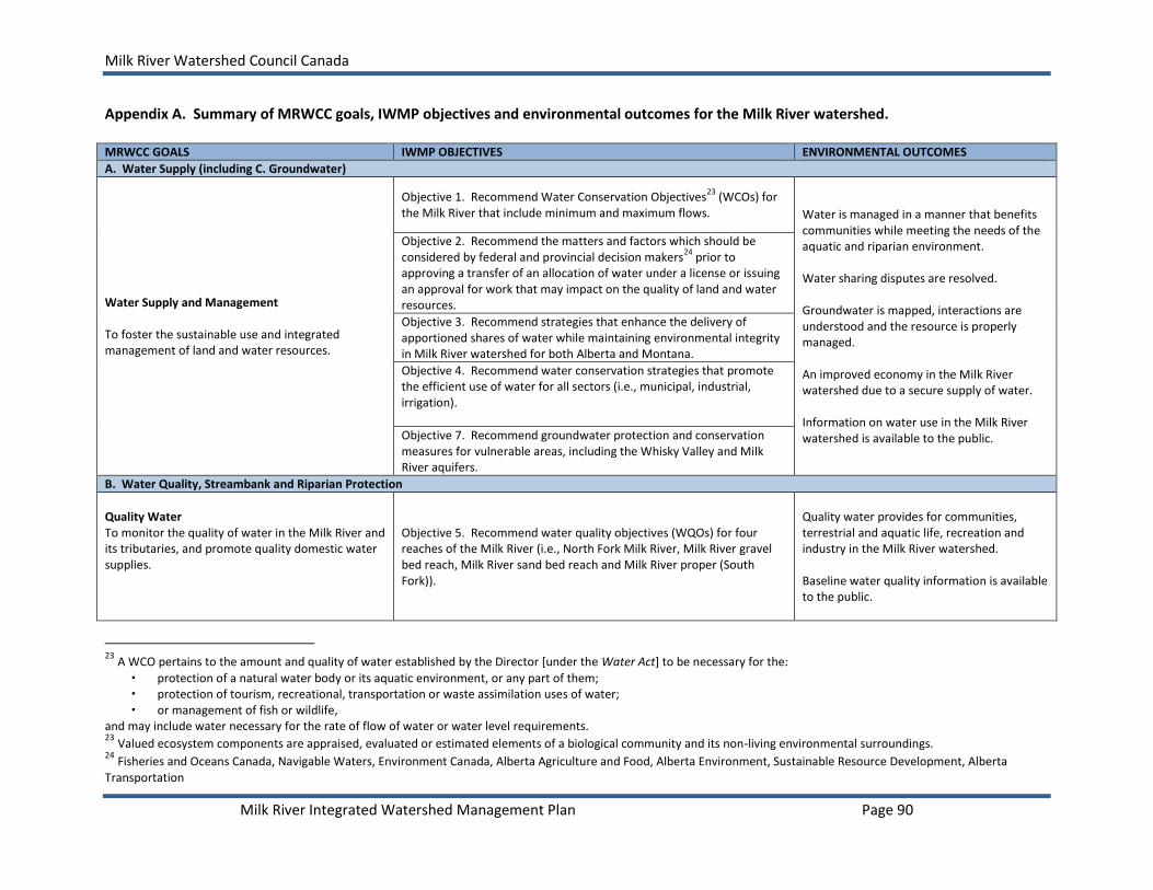
Milk River Watershed Council Canada
Milk River Integrated Watershed Management Plan Page 90
Appendix A. Summary of MRWCC goals, IWMP objectives and environmental outcomes for the Milk River watershed. MRWCC GOALS IWMP OBJECTIVES ENVIRONMENTAL OUTCOMES
A. Water Supply (including C. Groundwater)
Water Supply and Management To foster the sustainable use and integrated management of land and water resources.
Objective 1. Recommend Water Conservation Objectives23
(WCOs) for the Milk River that include minimum and maximum flows.
Water is managed in a manner that benefits communities while meeting the needs of the aquatic and riparian environment. Water sharing disputes are resolved. Groundwater is mapped, interactions are understood and the resource is properly managed. An improved economy in the Milk River watershed due to a secure supply of water. Information on water use in the Milk River watershed is available to the public.
Objective 2. Recommend the matters and factors which should be considered by federal and provincial decision makers
24 prior to
approving a transfer of an allocation of water under a license or issuing an approval for work that may impact on the quality of land and water resources.
Objective 3. Recommend strategies that enhance the delivery of apportioned shares of water while maintaining environmental integrity in Milk River watershed for both Alberta and Montana.
Objective 4. Recommend water conservation strategies that promote the efficient use of water for all sectors (i.e., municipal, industrial, irrigation).
Objective 7. Recommend groundwater protection and conservation measures for vulnerable areas, including the Whisky Valley and Milk River aquifers.
B. Water Quality, Streambank and Riparian Protection
Quality Water To monitor the quality of water in the Milk River and its tributaries, and promote quality domestic water supplies.
Objective 5. Recommend water quality objectives (WQOs) for four reaches of the Milk River (i.e., North Fork Milk River, Milk River gravel bed reach, Milk River sand bed reach and Milk River proper (South Fork)).
Quality water provides for communities, terrestrial and aquatic life, recreation and industry in the Milk River watershed. Baseline water quality information is available to the public.
23
A WCO pertains to the amount and quality of water established by the Director [under the Water Act] to be necessary for the:
protection of a natural water body or its aquatic environment, or any part of them; protection of tourism, recreational, transportation or waste assimilation uses of water; or management of fish or wildlife,
and may include water necessary for the rate of flow of water or water level requirements. 23
Valued ecosystem components are appraised, evaluated or estimated elements of a biological community and its non-living environmental surroundings. 24
Fisheries and Oceans Canada, Navigable Waters, Environment Canada, Alberta Agriculture and Food, Alberta Environment, Sustainable Resource Development, Alberta Transportation

Milk River Watershed Council Canada
Milk River Integrated Watershed Management Plan Page 91
MRWCC GOALS IWMP OBJECTIVES ENVIRONMENTAL OUTCOMES
Water quality and quantity information is used to achieve sustainable use and integrated management of water resources.
Riparian Protection To support and initiate programs that protect, maintain and improve riparian areas.
Objective 6. Recommend minimum setback requirements for development from the Milk River and its tributaries and recommend appropriate management strategies to protect and/or enhance riparian and aquatic ecosystems.
Healthy, functioning riparian areas contribute to streambank stability, good water quality, forage, shelter and biodiversity in the Milk River watershed.
D. Land Use
Economic Development To encourage economic development in the watershed.
Objective 8. Recommend land use and development practices which are congruent with the objectives and resource management strategies for the Milk River watershed and its unique semi-arid environment.
Innovative and sustainable land use and development practices take place in the watershed. A healthy, vibrant economy that will attract people and investment to the watershed.
E. Biodiversity
Biodiversity To increase knowledge and awareness of conservation initiatives in the watershed and facilitate partnerships that will conserve wildlife and plant species diversity.
Objective 9. Recommend strategies to conserve and enhance native wildlife and plant species diversity found within the watershed.
A diverse native wildlife and plant community is present in the Milk River watershed through habitat protection and enhancement efforts.
ADDITIONAL MRWCC GOALS
Informed Community To increase community awareness of the watershed.
A community that is informed and actively involved in the Milk River Watershed Council Canada and its initiatives.
National/International Issues To maintain open and accurate dialogue among the Milk River Watershed Council Canada and counterparts in Saskatchewan and Montana.
Good working relationships with Saskatchewan and Montana that create a process and forum to address transboundary watershed concerns.

Milk River Watershed Council Canada
Milk River Integrated Watershed Management Plan Page 92
Appendix B. Evaluation of flows required to safely navigate the Milk River by canoe, raft or tube as identified through scheduled canoe trips by local operators.
Scheduled Canoe Trips
Reach Navigated
Reason for Cancellation
Discharge (cms)
N. Milk River at Western Boundary (Reach 1)
Milk River at Western
Boundary (Reach 2)
Milk River at Milk River (Reach 3)
Milk River at Eastern
Boundary (Reach 4)
June 23, 2007 Coffin Bridge to
Weir Bridge -
12.100 0.656 15.900 16.900
June 28, 2008 Weir Bridge To
Deer Creek Bridge
-
16.600 2.490 20.100 18.500
June 27, 2009 Coffin Bridge to
Weir Bridge -
18.500 1.310 19.600 22.000
June 12, 2010 N. Fork Milk River to Del
Bonita Low Flow
3.817 3.505 8.518 19.356
June 18, 2010 -
High Flow
36.852 52.060 38.344 19.767
June 19, 2010 (scheduled date)
N. Fork Milk River to Del
Bonita 22.279 68.076 149.699 34.863
June 20, 2010 - 11.042 36.546 116.064 107.984
June 21, 2010 - 8.196 12.508 49.035 162.518
June 11, 2011 N. Fork Milk River to Del
Bonita High Flow 4.276 36.429 60.635 96.300
Note: To convert cubic metres per second (cms) to cubic feet per second (cfs), multiply cms by 35.32.
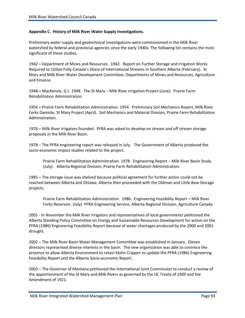
Milk River Watershed Council Canada
Milk River Integrated Watershed Management Plan Page 93
Appendix C. History of Milk River Water Supply Investigations. Preliminary water supply and geotechnical investigations were commissioned in the Milk River watershed by federal and provincial agencies since the early 1940s. The following list contains the most significant of these studies. 1942 – Department of Mines and Resources. 1942. Report on Further Storage and Irrigation Works Required to Utilize Fully Canada’s Share of International Streams in Southern Alberta (February). St Mary and Milk River Water Development Committee, Departments of Mines and Resources, Agriculture and Finance. 1948 – MacKenzie, G.L. 1948. The St Mary – Milk River Irrigation Project (June). Prairie Farm Rehabilitation Administration. 1954 – Prairie Farm Rehabilitation Administration. 1954. Preliminary Soil Mechanics Report, Milk River Forks Damsite, St Mary Project (April). Soil Mechanics and Material Division, Prairie Farm Rehabilitation Administration. 1976 – Milk River Irrigators founded. PFRA was asked to develop on stream and off stream storage proposals in the Milk River Basin. 1978 – The PFRA engineering report was released in July. The Government of Alberta produced the socio-economic impact studies related to the project.
Prairie Farm Rehabilitation Administration. 1978. Engineering Report – Milk River Basin Study (July). Alberta Regional Division, Prairie Farm Rehabilitation Administration.
1985 – The storage issue was shelved because political agreement for further action could not be reached between Alberta and Ottawa. Alberta then proceeded with the Oldman and Little Bow Storage projects.
Prairie Farm Rehabilitation Administration. 1986. Engineering Feasibility Report – Milk River Forks Reservoir. (July) PFRA Engineering Service, Alberta Regional Division, Agriculture Canada.
2001 - In November the Milk River Irrigators and representatives of local governments petitioned the Alberta Standing Policy Committee on Energy and Sustainable Resources Development for action on the PFRA (1986) Engineering Feasibility Report because of water shortages produced by the 2000 and 2001 drought. 2002 – The Milk River Basin Water Management Committee was established in January. Eleven directors represented diverse interests in the basin. The new organization was able to convince the province to allow Alberta Environment to retain Klohn Crippen to update the PFRA (1986) Engineering Feasibility Report and the Alberta Socio-economic Report. 2003 – The Governor of Montana petitioned the International Joint Commission to conduct a review of the apportionment of the St Mary and Milk Rivers as governed by the IJC Treaty of 1909 and the Amendment of 1921.

Milk River Watershed Council Canada
Milk River Integrated Watershed Management Plan Page 94
2004 – The Klohn Crippen Berger Preliminary Feasibility Study was presented to the Minister of Environment in April. No action taken to date because of the apportionment issue under consideration by the IJC. The study was not released to the public.
Klohn Crippen Berger in association with Mack, Slack & Associates Inc. and AXYS Environmental Consulting Ltd. 2003. Milk River Basin Preliminary Feasibility Study. Alberta Environment, Edmonton, AB.
The IJC established the St. Mary / Milk Rivers Administrative Measures Task Force, charged with examining opportunities to improve the administrative procedures for the apportionment of the St. Mary and Milk rivers to ensure more beneficial use and optimal receipt by both Canada and the United States of its apportioned water. 2006 – The joint IJC Team review of the matter resulted in a deadlock along national lines and a position of no recommendation. 2007 – A Joint International Team (JIT) was appointed by the Premier of Alberta and Governor of Montana to pursue an investigation of methods to make more effective use of the shared waters. Terms of Reference adopted in December 2008 for the new St. Mary-Milk River Water Management Initiative. The final reports are expected by fall 2014. 2008 – The MRWCC commissioned the Supplemental Water Supply Investigations (Klohn Crippen Berger 2008) to review options to augment Milk River flows, including the feasibility of transferring water from Ridge Reservoir to the Milk River.
Klohn Crippen Berger. 2008. Supplemental Water Supply Investigation. Milk River Watershed Council Canada, Milk River, Alberta. 86 pp. plus Appendix.
2009 – The MRWCC completed Part II of the Supplemental Water Supply Investigation to understand the economic implications of alternative Ridge Reservoir diversions.
Marv Anderson & Associates Ltd. 2009. Milk River Supplemental Water Supply Investigation Part II: Economic Analysis of Alternative Ridge Reservoir Diversions. Milk River Watershed Council Canada, Milk River, Alberta. 46 pp. plus Appendix.
2013 – ESRD water conversations and Draft SSRP clearly outline need for storage within the Milk River Basin.
Water Conversations What We Heard Summary (AESRD 2013) Accessed May 2014: http://aesrd.wordpress.com/category/water-conversaton/ Draft South Saskatchewan Regional Plan (AESRD 2013) Accessed May 2014: https://landuse.alberta.ca/LandUse%20Documents/SSRP%20Draft%20SSRP%202014-2024_2013-10-10.pdf
2014 – The basis for Montana’s request to the International Joint Commission to review the terms of 1921 Order that details the apportionment of the St. Mary River and Milk River flows has dissipated. A

Milk River Watershed Council Canada
Milk River Integrated Watershed Management Plan Page 95
water storage project could proceed as an Alberta project while meeting all international obligations. A joint mutually beneficial project at a future date is possible. 2014 – MRWCC requests that a decision of support be made regarding a water storage project on the Milk River. Public Provincial support for a water storage project on the Milk River, in principal, would trigger a formal Environmental Impact Assessment, consultations with First Nations, and detailed engineering studies that would aid in the final decision to construct or forego a storage project on the Milk River.

Milk River Watershed Council Canada
Milk River Integrated Watershed Management Plan Page 96
Appendix D. Groundwater maps. D.1. Thickness and distribution of the Whisky Valley Aquifer (Golder Associates 2004).

Milk River Watershed Council Canada
Milk River Integrated Watershed Management Plan Page 97
D.2. Whisky Valley Aquifer vulnerability map (Golder 2004).

Milk River Watershed Council Canada
Milk River Integrated Watershed Management Plan Page 98
D.3. Map showing Alberta and Montana and the extent of the Milk River Aquifer project area (Petre, 2012). The hatched area corresponds to areas where the Milk River Formation outcrops.

Milk River Watershed Council Canada
Milk River Integrated Watershed Management Plan Page 99
Appendix E. Milk River watershed surficial geology map.
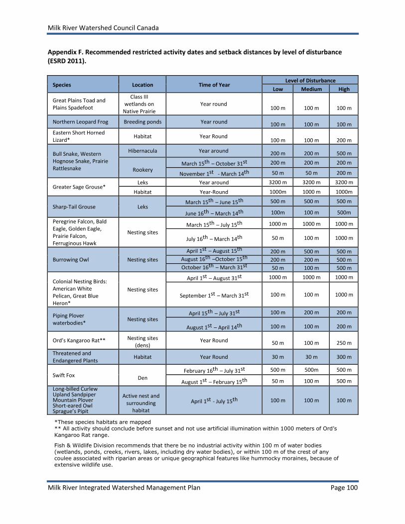
Milk River Watershed Council Canada
Milk River Integrated Watershed Management Plan Page 100
Appendix F. Recommended restricted activity dates and setback distances by level of disturbance (ESRD 2011).
Species Location Time of Year Level of Disturbance
Low Medium High
Great Plains Toad and Plains Spadefoot
Class III wetlands on
Native Prairie Year round
100 m
100 m
100 m
Northern Leopard Frog Breeding ponds Year round
100 m
100 m
100 m
Eastern Short Horned Lizard*
Habitat Year Round
100 m
100 m
200 m
Bull Snake, Western Hognose Snake, Prairie Rattlesnake
Hibernacula Year around
200 m
200 m
500 m
Rookery
March 15th – October 31st 200 m 200 m 200 m
November 1st - March 14th 50 m 50 m 200 m
Greater Sage Grouse* Leks Year around 3200 m 3200 m 3200 m
Habitat Year-Round 1000m 1000 m 1000m
Sharp-Tail Grouse Leks March 15th – June 15th 500 m 500 m 500 m
June 16th – March 14th 100m 100 m 500m
Peregrine Falcon, Bald Eagle, Golden Eagle, Prairie Falcon, Ferruginous Hawk
Nesting sites
March 15th – July 15th 1000 m 1000 m 1000 m
July 16th – March 14th 50 m 100 m 1000 m
Burrowing Owl Nesting sites
April 1st – August 15th 200 m 500 m 500 m
August 16th –October 15th 200 m 200 m 500 m
October 16th – March 31st 50 m 100 m 500 m Colonial Nesting Birds: American White Pelican, Great Blue Heron*
Nesting sites
April 1st – August 31st 1000 m 1000 m 1000 m
September 1st – March 31st 100 m 100 m 1000 m
Piping Plover waterbodies*
Nesting sites April 15th – July 31st 100 m 200 m 200 m
August 1st – April 14th
100 m
100 m
200 m
Ord’s Kangaroo Rat** Nesting sites (dens)
Year Round
50 m
100 m
250 m
Threatened and Endangered Plants
Habitat Year Round 30 m 30 m 300 m
Swift Fox
Den February 16th – July 31st 500 m 500m 500 m
August 1st – February 15th 50 m 100 m 500 m
Long-billed Curlew Upland Sandpiper Mountain Plover Short-eared Owl Sprague’s Pipit
Active nest and
surrounding habitat
April 1st - July 15th 100 m 100 m 100 m
*These species habitats are mapped ** All activity should conclude before sunset and not use artificial illumination within 1000 meters of Ord’s
Kangaroo Rat range.
Fish & Wildlife Division recommends that there be no industrial activity within 100 m of water bodies (wetlands, ponds, creeks, rivers, lakes, including dry water bodies), or within 100 m of the crest of any coulee associated with riparian areas or unique geographical features like hummocky moraines, because of extensive wildlife use.

Milk River Watershed Council Canada
Milk River Integrated Watershed Management Plan Page 101
Appendix G. Summary of objectives and action recommendations for listed indicator wildlife species taken from Minister approved national Recovery Plans, ASRD-FWD approved Management Plans, and existing government planning documents. Indicator Species
Goal Recommendations Priority Implementation Actions
Northern Leopard Frog
To conserve northern leopard frogs and their associated habitat within the Milk River Basin (Northern Leopard Frog Recovery Team 2005).
Advise local landholders of land management practices which enhance the habitat and survival of northern leopard frogs. (Northern Leopard Frog Recovery Team 2005)
M Establish partnerships with existing non-government organizations (NGOs) to achieve education and awareness recommendations.
Plains Spadefoot / Great Plains Toad
To conserve ephemeral wetlands from physical destruction and habitat degradation, in order to provide habitat for a unique assemblage of associated species (ASRD 2004).
Maintain ephemeral wetlands and the water quality associated with these wetlands. (Green et al. 2004, Michalsky et al. 2004)
M Establish partnerships with existing NGOs to implement best management practices (BMPs) in areas significant for the great plains toad or plains spadefoot (RCS 2004).
Pronghorn To ensure that viable populations of pronghorn antelope are maintained throughout the Milk River Basin.
1. Facilitate pronghorn movements throughout the Milk River Basin. (Alberta Fish and Wildlife Division 1990) 2. Maintain habitat quality on all pronghorn wintering areas. (Alberta Fish and Wildlife Division 1990)
M
M
1. Provide information on wildlife friendly fencing (Paige 2008) to landholders. Partner with government and non-government organizations to implement wildlife friendly fencing demonstration sites. 2. Establish partnerships with existing non-government organizations to implement BMPs for pronghorn (Fish and Wildlife Division 1990).
Prairie Rattlesnake
Maintain the population of prairie rattlesnakes within the Milk River Basin.
1. Protect prairie rattlesnake overwintering sites (hibernacula) and birthing sites (rookeries) through stewardship activities. 2. Identify areas of high road mortality for prairie rattlesnakes and develop and implement methods to mitigate the impacts of roads in these areas.
H
M
1. Identify existing and potential hibernacula sites to Alberta Fish and Wildlife Division. 2. Develop a reporting system for snakes found dead along roadways to determine areas for future mitigation action. The identification of hibernacula sites will assist with industrial development siting and route selection, with municipal planning, and will reduce the number of snake/human conflicts within the basin. High risk road crossings will be identified through a reporting system and alternative mitigation measures can be developed to

Milk River Watershed Council Canada
Milk River Integrated Watershed Management Plan Page 102
Indicator Species
Goal Recommendations Priority Implementation Actions
limit the negative impacts of roads on the prairie rattlesnake (e.g. use of signs).
Greater Sage Grouse
Enhance and maintain habitat for sage-grouse to satisfy life cycle requirements in support of a viable population within its remaining historical range (The Greater Sage Grouse Action Team 2005).
Manage for appropriate range health for sage grouse on grazing leases and private land. (The Greater Sage Grouse Action Team 2005)
Supplemental winter feeding of livestock should not take place in key Sage-Grouse wintering habitats.
Avoid placing salt, minerals or supplements within 0.8 km. of lek sites to minimize disturbance. (Adams et al. 2004)
H 1. Establish partnerships with existing NGOs to implement BMPs. (Adams et.al. 2004) 2. Investigate incentives at the County level that promote good stewardship for Greater Sage-Grouse and other species at risk within the Milk River Basin. 3. Educate and increase awareness among the general public that ranchers are retaining native prairie habitats and grazing it in a manner compatible with the habitat needs of the sage grouse in order that ranchers who provide this important service might be rewarded.
Sharp-tailed Grouse
To ensure a viable population of sharp-tailed grouse within the Milk River Basin.
Maintain nesting and lek habitat for the sharp-tailed grouse.
medium 1. Establish partnerships with existing NGOs to implement BMPs for the sharp-tailed grouse. 2. To assist with the discovery of new dancing grounds, landowners and lessees are encouraged to notify Alberta
Fish and Wildlife of the location of any known lek sites. Burrowing Owl
Maintain and conserve breeding habitat for the burrowing owl in order to contribute to the provincial recovery goal of increasing the population to natural self-sustaining levels (Alberta Burrowing Owl Recovery Team 2005).
1. Promote habitat conservation programs which support private landholders in managing habitat for burrowing owls. (The Burrowing Owl Recovery Team 2006) 2.Ensure adequate numbers and distribution of nest burrows created by badgers and ground squirrels. (The Burrowing Owl Recovery Team 2005). 3. Participate in research project for burrowing owls survival rates, extent
M
H
1. Promote habitat conservation programs which provide information and support to local landholders who have burrowing owls and other species at risk. Support the implementation of BMPs for burrowing owls. 2. Encourage land managers to maintain populations of fossorial mammals (i.e., burrowing mammals having limbs adapted for digging) that provide burrows for burrowing owls. seek landowner support for maintaining fossorial
mammals through education initiatives that target property owners and leaseholders
determine what level of acceptance (i.e., social tolerance) landowners have for fossorial mammals.

Milk River Watershed Council Canada
Milk River Integrated Watershed Management Plan Page 103
Indicator Species
Goal Recommendations Priority Implementation Actions
and impact of juvenile dispersal, grazing practices on prey species, and effect of contaminants on survival and reproduction.
H
3. Use extension and education programs, to ensure that trapping, poisoning, and hunting do not eradicate local populations of fossorial mammals. 4. Maintain small mammal populations to provide an adequate prey source for other species at risk including the ferruginous hawk. 5. Balance pest control and the needs of the burrowing owl to ensure the survival of the species while meeting the needs of landholders.
Ferruginous Hawk
Conserve nesting habitats, including nest sites, and foraging habitat for the ferruginous hawk in order to contribute to the provincial population goal. (Alberta Ferruginous Hawk Recovery Team 2009).
1. To maintain existing grasslands on both public and private lands and where opportunity exists, increase the acreage of grasslands (Alberta Ferruginous Hawk Recovery Team 2009). 2. To ensure ferruginous hawk prey availability is considered in range management plans and recommendations (Alberta Ferruginous Hawk Recovery Team 2009).
H
M
1. Inform private landholders of the importance of naturally-occurring trees and shrubs as important components of the prairie ecosystem, and encourage, through stewardship programs, their protection from destruction, and their careful management. 2. Install nest platforms in suitable habitat based on the established nest protocol (Migaj et. al. 2011). Ensure that artificial sites are placed properly to avoid conflicts with other species at risk. 3. Provide information on financial incentives to ranchers and farmers who are maintaining natural habitats for species at risk such as ferruginous hawks. 4. Market Incentives: encourage urban consumers to purchase open range-
raised beef. promote market demand for labelling to identify beef
produced by “Endangered Species Friendly” producers, leading to a system of market-based incentives to producers for providing species at risk habitat
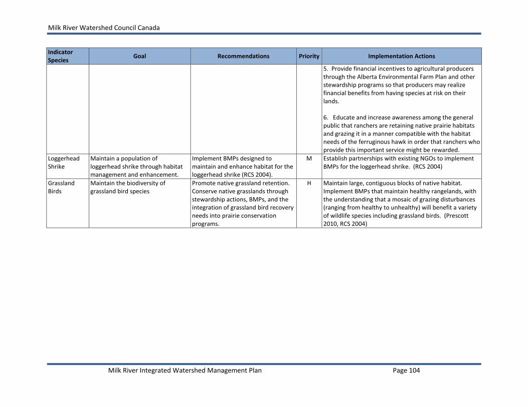
Milk River Watershed Council Canada
Milk River Integrated Watershed Management Plan Page 104
Indicator Species
Goal Recommendations Priority Implementation Actions
5. Provide financial incentives to agricultural producers through the Alberta Environmental Farm Plan and other stewardship programs so that producers may realize financial benefits from having species at risk on their lands. 6. Educate and increase awareness among the general public that ranchers are retaining native prairie habitats and grazing it in a manner compatible with the habitat needs of the ferruginous hawk in order that ranchers who provide this important service might be rewarded.
Loggerhead Shrike
Maintain a population of loggerhead shrike through habitat management and enhancement.
Implement BMPs designed to maintain and enhance habitat for the loggerhead shrike (RCS 2004).
M Establish partnerships with existing NGOs to implement BMPs for the loggerhead shrike. (RCS 2004)
Grassland Birds
Maintain the biodiversity of grassland bird species
Promote native grassland retention. Conserve native grasslands through stewardship actions, BMPs, and the integration of grassland bird recovery needs into prairie conservation programs.
H Maintain large, contiguous blocks of native habitat. Implement BMPs that maintain healthy rangelands, with the understanding that a mosaic of grazing disturbances (ranging from healthy to unhealthy) will benefit a variety of wildlife species including grassland birds. (Prescott 2010, RCS 2004)

Milk River Watershed Council Canada
Milk River Integrated Watershed Management Plan Page 105
Appendix H. Overview of range health and assessment and “good standing”. Readers are encouraged to review section 6.1 (“Public Range Health”) in the Milk River State of the Watershed report for an explanation of management issues that pertain to rangelands within the basin. Also addressed in this section of the SOW report is a description of the five rangeland health indicators used by SRD and how rangeland health scores are established for public rangelands. The 5 indicators used to determine rangeland health and function are:
1. Integrity and Ecological Status 2. Plant Community Structure 3. Hydrologic Function and Nutrient Cycling 4. Site Stability 5. Noxious Weeds
Once a rangeland site has been assessed, the combined score of the above indicators is expressed as a percent health rating. This figure can then be compared against three range health categories to determine the condition of the assessed rangeland site:
a score of 75 -100% = Healthy a score of 50 – 74% = Healthy with problems (further monitoring is needed; adjustments in grazing practices may be required) a score of < 50% = Unhealthy (urgent management action may be required)
A disposition under the Public Lands Act is assessed against the following 3 categories and a decision is made whether to renew or not renew a grazing disposition. 1) Disposition Use
a) “Acceptable” use means that the disposition is being used properly. b) “Unacceptable” use could include such things as: severe over-grazing, failure to graze a lease (without approval), and unauthorized subletting of the lease. 2) Health
a) Range health could be considered “Acceptable” if it was determined to be: i) healthy or healthy with problems on the majority of the grazing lease, ii) lower than healthy with problems but there is an upward trend or identified health problems have been addressed, or iii) affected by external factors beyond the control of the lessee.
b) Range health is considered to be “Unacceptable” when range condition has been determined to be unhealthy on the majority of the grazing lease.
3) Proper Management a) “Acceptable” is considered when the disposition is being used appropriately and conditions of the disposition, range management operation plan (RMOP) or other planning agreements are being followed and the Public Lands Act is not being contravened. b) “Unacceptable” is considered when the disposition is not being used appropriately, i.e., if conditions of the disposition, RMOP or other planning agreements are not being followed and/or regulations defined in the Public Lands Act may have been contravened.
If one of more of the above three categories is not met the grazing lease is considered to be “not in good standing” and is subject to progressive compliance measures as outlined in the Public Lands Act.

Milk River Watershed Council Canada
Milk River Integrated Watershed Management Plan Page 106
Appendix I. Enhanced Approval Process recommendations. The recommendations apply a minimum disturbance development philosophy.
Objective EAP Recommendations
1. Apply an overall land management strategy that emphasizes IRM while allowing compatible industrial and commercial development to occur.
1. Utilize the concept of IRM25
and ILM26
when making decisions on the suitability and extent of industrial and commercial development within the watershed.
Activities should be planned in a manner that minimizes disturbance and adverse environmental effects. Areas that need special consideration include: sensitive soils, unstable slopes, waterbodies, wetlands, streams, areas where rare plants or animals are found, breeding grounds, nesting areas or winter range.
2. Minimize fragmentation of the landscape and the number of linear features by using shared corridors.
3. Development should be located to minimize the amount of borrowed material (i.e., subsoil, sand and gravel) needed.
4. Road design should consider the following: minimize the number of watercourse crossings; minimize the total footprint; minimize new clearings; minimize the grade of roads, and; avoid loop roads.
5. Minimal disturbance (no strip) access roads/trails should be utilized whenever possible.
6. Access routes should be planned such that future corridor requirements are considered and integrated.
7. Industrial activity should be sequenced to avoid repeat operations or multiple entries into an area.
8. Exploration activity should only utilize minimal disturbance access while keeping corridor width to a minimum.
9. New development/disturbance must take into account impacts to other users (human and non-human) of the landscape.
10. Existing sites where on-site contamination issues are present should be avoided for future development.
11. Selected linear development routes should allow for future field expansion.
12. Regardless of approved widths, attempts should be made to utilize the least-width for linear features.
13. Pipeline ROW should not be used as access shortcuts during construction.
14. Attempts should be made to locate any borrow pits as close to the development as possible and spoil piles from existing dugouts should be utilized where ever possible.
15. Where multiple pipelines are planned, utilize a common trench and corridor to minimize the industrial footprint.
16. Utilize existing leases and directional, slant and horizontal drilling techniques to reach subsurface targets and minimize the development footprint.
17. Constant and ongoing monitoring of industrial developments must occur to ensure negative impacts do not affect landscape resources.
18. Development planning should consider viewscapes and landscape aesthetics when locating industrial and commercial activities within sensitive or valued landscapes.
2. Maintain and protect water 1. Avoid locating parallel, all-weather access routes within 500m of any waterbody/watercourse.
25
IRM – Integrated Resource Management 26 ILM – Integrated Land Management

Milk River Watershed Council Canada
Milk River Integrated Watershed Management Plan Page 107
Objective EAP Recommendations
quality, waterbodies and watercourses while allowing for industrial and commercial development.
2. Where topography limits the ability to locate roads away from riparian areas, access roads should be located as far from the bed and shore as possible.
3. Pipelines should be bored through watercourses and waterbodies where possible. If an open trench is deemed less risky, consideration should be given to installing a second pipeline at the crossing point to accommodate future capacity needs.
4. Stream crossings should be located at stable channel locations, not actively eroding areas. All equipment should be kept clean and not be a source of sediment or contaminants.
5. Snow fills may be used on ephemeral watercourses during frozen conditions provided that: sufficient snow exists to fill the creek channel, any soil cap on the snow is remove prior to breakup, measures are in place to prevent soil or other debris from entering the watercourse channel, and suitable measures are taken during deactivation to ensure flow is not impeded.
6. Ice bridges may be used during frozen conditions provided that: no capping of soil or organic material takes place, winter flows are not impeded, snow and ice approaches are sufficiently thick to protect the bed and shore, and measures are taken during deactivation to ensure flows are not impeded.
7. Culverts can be installed on watercourses provided the following is taken into account: culverts must be maintained and repaired to ensure the integrity of the structure is not compromised, culverts are clearly flagged to identify them and prevent damage by road maintenance activities, culverts must be regularly cleaned to clear blockages of soil/vegetation that might restrict flow.
3. Maintain and protect the soil resource while allowing for industrial and commercial development to occur.
1. Industrial and commercial activities should be routed around sensitive terrain and soils. Sensitive terrain types include: dunes, eroding slopes, coulee breaks and wet, shallow or salt effected soils.
2. In areas where development cannot avoid sensitive terrain or soils, minimal disturbance (no strip) techniques should be utilized.
3. Utilize minimal disturbance techniques to minimize damage to the vegetation that anchors and protects the soil resource.
4. Some soil conditions may require the use of “three-lift stripping” techniques (i.e., separation of: top soil, B and other intermediate horizons, parent material). In order to prevent long term storage and erosion, replacement of the soil should be done within a reasonable time period.
4. Maintain and protect the native vegetation resource while allowing for industrial and commercial development to occur.
1. Utilize minimal disturbance (no strip) techniques to preserve native vegetation.
2. Where vegetation control is needed, utilize mechanical over chemical control techniques to prevent chemical migration. Chemical control should only be used when spot application treatments are undertaken.
3. Industrial proponents must have a fire control plan with all necessary fire fighting equipment readily available or on-site. All staff must be trained to use fire fighting equipment.
5. Maintain and protect established grazing operations within the watershed while allowing for industrial and
1. New development will make full and preferential use of existing access and development leases.
2. After development completion final cleanup of industrial and commercial sites should occur prior to cattle entry in the affected field(s).
3. Existing access corridors should be used. Fences should not be cut and access should be gained through existing gates.

Milk River Watershed Council Canada
Milk River Integrated Watershed Management Plan Page 108
Objective EAP Recommendations
commercial development to occur.
4. Pipelines or underground power lines that intersect buffers between roads and fields should be avoided or bored to maintain winter cover.
5. Gates that receive high levels of use resulting from the industrial activity should be replaced with Texas gates where appropriate and supported by the grazing Lessee.
6. Consider hanging swing gates over Texas gates where adjacent to high traffic livestock areas.
7. In order to reduce generation of airborne dust, industrial traffic speed should be kept to a minimum (30-50kph) where the access is located in close proximity to livestock.
8. Always fence out borrow pits to eliminate livestock injury.
9. To avoid injury to livestock, eliminate the use of horns and sirens when in close proximity to livestock.