Embed Size (px)
Citation preview
122
2A
ORANGE
ATHOL
East River Street
West River Street
West Main Street
East Main Street
South Main Street
Brookside Rd.
Fisher Hill764 ft.
Cook’s Cove
The Branch
LakeRohuntaLake
Mattawa
Daniel Shays Hwy.
South Athol Rd.
West Brook
Tully River
Gulf B
rook
Red Br
ook
Shing
le Sw
amp B
rook
Fall H
ill Br
ook
Ice Comp any Brook
Mill Brook
Exchange St.
To Routes 2 & 202 and Quabbin Reservoir
To Routes 2 & 32
To Route 2
Millers RiverEnvironmental Center
MREC
6
5
2
3
1
4
7
8
911
12
13
14
15
16
17
18
19
20
21
22
23242526
10
CEM
Orange Municipal Airport
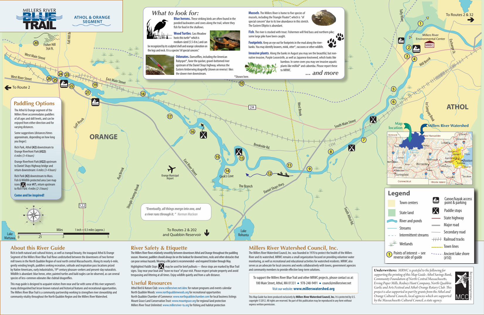
LegendTown centers
State land
Canoe/kayak access point & parking
Ancient lake shore (#10)
Wetlands
River and ponds
Points of interest – seereverse side of guide
Streams
Intermittent streams
State highway
Major road
Secondary road
Railroad tracks
Town lines
Paddle stops
1About this River GuideRich in both natural and cultural history, as well as tranquil beauty, the inaugural Athol & Orange Segment of the Millers River Blue Trail flows undisturbed between the downtowns of two former mill towns in the North Quabbin Region of rural north central Massachusetts. Along its nearly 6-mile, gently winding length, paddlers seeking recreation, solitude and inspiration pass locations prized by Native Americans, early industrialists, 19th century pleasure-seekers and present-day naturalists. Wildlife is abundant : blue heron, otter, painted turtles and bald eagles can be observed, as can several species of less-common odonates like clubtail dragonflies.
This map guide is designed to acquaint visitors from near and far with some of this river segment’s many distinguished but lesser known natural and historical features and recreational opportunities. The Millers River Blue Trail is a community partnership working to strengthen river stewardship and community vitality throughout the North Quabbin Region and the Millers River Watershed.
River Safety & EtiquetteThe Millers River flows relatively smoothly between downtown Athol and Orange throughout the paddling season. However, paddlers should always be on the lookout for downed trees, rocks and other obstacles that can pose serious hazards. Wearing a life jacket is recommended--and required October through May.
Highlighted Paddle Stops may be used for brief pullouts— these stops are marked by Blue Trail signs. Stay near your boat and “leave no trace” of your visit. Please respect private property and avoid trespassing and littering at all times. Enjoy wildlife quietly and from a safe distance.
Useful ResourcesAthol Bird & Nature Club: www.millersriver.net/abnc for nature programs and events calendarNorth Quabbin Woods: www.northquabbinwoods.org for recreational opportunitiesNorth Quabbin Chamber of Commerce: www.northquabbinchamber.com for local business listingsMount Grace Land Conservation Trust: www.mountgrace.org for regional land protection Millers River Trout Unlimited: www.millersriver-tu.org for fishing and habitat protection
Millers River Watershed Council, Inc. The Millers River Watershed Council, Inc. was founded in 1970 to protect the health of the Millers River and its watershed. MRWC remains a small organization focused on providing volunteer water monitoring, as well as recreational and educational activities for watershed residents. MRWC also serves as an advocate for local concerns and works collaboratively with towns, government agencies and community members to provide effective long-term solutions.
What to look for:
... and more
Paddling Options
Blue herons. These striking birds are often found in the ponded backwaters and coves along the trail, where they fish for food in the shallows.
Wood Turtles. Cass Meadow hosts this turtle* which is medium-sized (5.5-8 in.) and can
be recognized by its sculpted shell and orange coloration on the legs and neck. It is a species “of special concern.”
Odonates. Damselflies, including the American Rubyspot*, favor the quicker, gravel-bottomed river upstream of the Daniel Shays highway, whereas the Eastern Amberwing dragonfly (shown on reverse) likes the slower river downstream.
The Athol & Orange segment of the Millers River accommodates paddlers of all ages and skill levels, and can be enjoyed from either direction and for varying distances.
Some suggestions (distances/times approximate, depending on how long you linger):
Rich Park, Athol (#2) downstream to Orange Riverfront Park (#22): 6 miles (3-4 hours)
Orange Riverfront Park (#22) upstream to Daniel Shays Highway bridge and return downstream: 6 miles (3-4 hours)
Rich Park (#2) downstream to Mass. Fish & Wildlife protected area (see map icons near #7), return upstream to Rich Park: 4 miles (2-3 hours)
Come and be inspired!
Mille
rs
2
32
202
Maplocation Millers River Watershed
Mussels. The Millers River is home to five species of mussels, including the Triangle Floater*, which is “of special concern” due to its low abundance in this stretch. The Eastern Elliptio is abundant.
Fish. The river is stocked with trout. Fishermen will find bass and northern pike; some large pike have been caught.
Footprints. Keep an eye out for footprints in the mud along the river-banks. You may identify beavers, mink, otter*, raccoons or other wildlife.
Invasive plants. Along the banks in August you may see the beautiful, but non-native invasive, Purple Loosestrife, as well as Japanese knotweed, which looks like
bamboo. In some coves you may see invasive aquatic plants like milfoil* and cabomba. Please report these to MRWC.
*Shown here.
To support the Millers River Blue Trail and other MRWC projects, please contact us at: 100 Main Street, Athol, MA 01331 • 978-248-9491 • [email protected]
Visit our website: www.millerswatershed.org
Athol & orAngeSegment
0 .25 .5
Miles
1
1 inch = 0.3 miles (approx.)
This Map Guide has been produced exclusively by Millers River Watershed Council, Inc. It is protected by U.S. copyright ©2012. All rights are reserved. No part of this publication may be reproduced in any form without express written permission.
Underwriters: MRWC is grateful to the following for supporting the printing of this Map Guide: Athol Savings Bank, Community Foundation of North Central Massachusetts, Erving Paper Mills, Rodney Hunt Company, North Quabbin Garlic and Arts Festival and Athol-Orange Rotary Club. This project is also supported in part by grants from the Athol and Orange Cultural Councils, local agencies which are supported by the Massachusetts Cultural Council, a state agency.
“Eventually, all things merge into one, and a river runs through it. “ Norman Maclean