Embed Size (px)
Citation preview
MILPITAS GENERAL PLAN
2-1
Purpose
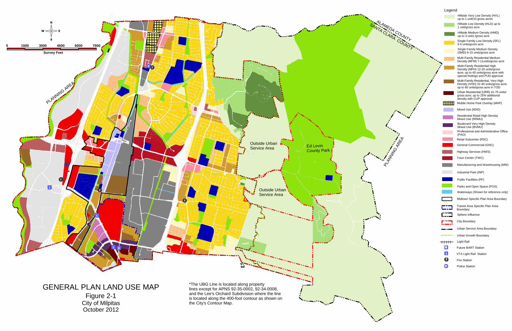
The text and policies of the Land Use Element, and the General Plan Diagram (color foldout Figure 2-1) provide the physical framework for development in the Planning Area. The Diagram designates the proposed general location, distribution and extent of land uses. Uses on sites less than two acres in size are generally not depicted on the Diagram. As required by state law, land use classifications, shown as letter designations, labels or graphic patterns on the Diagram, specify a range for population density and building intensity for each type of designated land use. These standards of population density and building intensity allow circulation and public facility needs to be determined; they also reflect the environmental carrying-capacity limitations established by other elements of the General Plan.
Relationship to Other Elements
The Land Use Element correlates land use policies contained in the other elements. Land Use designations on the General Plan Diagram, and building density and intensity standards contained in the Land Use Element provide a basis for determining future traffic conditions and the need for capital facilities, such as street improvements, parks and schools.

MILPITAS GENERAL PLAN
2-2
MILPITAS GENERAL PLAN
2-3
2 . 1 P o p u l a t i o n a n d G r o w t h
Population Growth
The Planning Area's 2010 population is 69,100. Between 2000 and 2010, the Planning Area population increase by 6,290 people at a rate of 1.00 percent per year. Build-out under the 2010 land use designations of the General Plan would result in an additional population of approximately 37,000 in the City, or a total population of about 106,100 in the Planning Area. However, this may be affected as a result of any Plan amendments that may subsequently be adopted.
While build-out of the General Plan is expected to occur over a 15- to 25-year period, the time at which build-out would occur is not specified in or anticipated by the Plan.
Land Availability
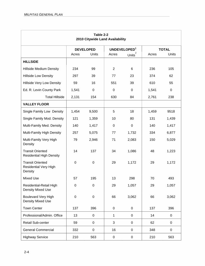
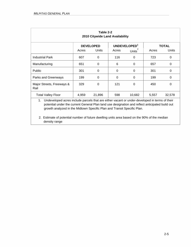
Table 2-2 summarizes the status, as of May 2010, of developed and vacant land within City limits under the different General Plan land use classifications. About one-third of the developed land in the Valley Floor is devoted to Single Family Low-Density Residential use, with all designated residential areas accounting for about 46 percent of the Valley Floor. About 25 percent of the Valley Floor is designated for industrial (Manufacturing and Industrial Park) uses. About 15 percent of the total land in the Valley Floor is vacant and available for development.
Table 2-1
Population Estimates and Projections
2010
2015
2020
2025
2030
2035
City of Milpitas 69,000 74,700 82,300 90,400 98,100 106,000
Milpitas Planning
Area 69,100 74,800 82,400 90,500 98,200 106,100
Santa Clara
County 1,822,000 1,945,300 2,063,100 1,185,800 2,310,800 2,431,400
Sources: Association of Bay Area Governments, Projections and Priorities 2009
MILPITAS GENERAL PLAN
2-4
Table 2-2 2010 Citywide Land Availability
DEVELOPED UNDEVELOPED1 TOTAL Acres Units Acres
Units2 Acres Units
HILLSIDE
Hillside Medium Density 234 99 2 6 236 105
Hillside Low Density 297 39 77 23 374 62
Hillside Very Low Density 59 16 551 39 610 55
Ed. R. Levin County Park 1,541 0 0 0 1,541 0
Total Hillside 2,131 154 630 84 2,761 238
VALLEY FLOOR
Single Family Low Density 1,454 9,500 5 18 1,459 9518
Single Family Mod. Density 121 1,359 10 80 131 1,439
Multi-Family Med. Density 140 1,417 0 0 140 1,417
Multi-Family High Density 257 5,075 77 1,732 334 6,877
Multi-Family Very High Density
79 2,946 71 2,083 150 5,029
Transit Oriented Residential High Density
14 137 34 1,086 48 1,223
Transit Oriented Residential Very High Density
0 0 29 1,172 29 1,172
Mixed Use 57 195 13 298 70 493
Residential-Retail High Density Mixed Use
0 0 29 1,057 29 1,057
Boulevard Very High Density Mixed Use
0 0 66 3,062 66 3,062
Town Center 137 396 0 0 137 396
Professional/Admin. Office 13 0 1 0 14 0
Retail Sub-center 59 0 3 0 62 0
General Commercial 332 0 16 0 348 0
Highway Service 210 563 0 0 210 563
MILPITAS GENERAL PLAN
2-5
Table 2-2 2010 Citywide Land Availability
DEVELOPED UNDEVELOPED1 TOTAL Acres Units Acres
Units2 Acres Units
Industrial Park 607 0 116 0 723 0
Manufacturing 651 0 6 0 657 0
Public 301 0 0 0 301 0
Parks and Greenways 199 0 0 0 199 0
Major Streets, Freeways & Rail
329 0 121 0 450 0
Total Valley Floor 4,959 21,896 598 10,682 5,557 32,578
1. Undeveloped acres include parcels that are either vacant or under-developed in terms of their potential under the current General Plan land use designation and reflect anticipated build out growth analyzed in the Midtown Specific Plan and Transit Specific Plan.
2. Estimate of potential number of future dwelling units area based on the 90% of the median density range
Ed Levin County Park
Outside Urban Service Area
Outside Urban Service Area
PLAN
NING
ARE
A
ALAMEDA COUNTY
SANTA CLARA COUNTY
PLANNING AREA
0 1500 3000 4500 6000 7500
Survey Feet
GENERAL PLAN LAND USE MAPFigure 2-1
City of MilpitasOctober 2012
Midtown Specific Plan Area Boundary
Transit Area Specific Plan AreaBoundary
Sphere Influence
City Boundary
Urban Service Area Boundary
Urban Growth Boundary
Light Rail
Future BART Station
VTA Light Rail Station
Fire Station
Police Station
LegendHillside Very Low Density (HVL)up to 1 unit/10 gross acres
Hillside Medium Density (HMD)up to 3 units /gross acre
Hillside Low Density (HLD) up to1 unit/gross acre
Single Family Low Density (SFL)3-5 units/gross acreSingle Family Medium Density(SMD) 6-15 units/gross acre
Multi-Family Residential MediumDensity (MFM) 7-11units/gross acreMulti-Family Residential HighDensity (MFH) 12-20 units/grossacre; up to 40 units/gross acre withspecial findings and PUD approvalMulti-Family Residential, Very HighDensity (VHD) 31-40 units/gross acre;up to 60 units/gross acre in TODUrban Residential (URR) 41-75 units/gross acre; up to 25% additionaldensity with CUP approvalMobile Home Park Overlay (MHP)
Mixed Use (MXD)
Residential Retail High DenistyMixed Use (RRMU)Boulevard Very High DensityMixed Use (BVMU)Professional and Administrative Office(PAO)Retail Subcenter (RSC)
General Commercial (GNC)
Highway Services (HWS)
Town Center (TWC)
Manufacturing and Warehousing (MW)
Industrial Park (INP)
Public Facilities (PF)
Parks and Open Space (POS)
Waterways (Shown for reference only)
*The UBG Line is located along propertylines except for APNS 92-35-0002, 92-34-0008,and the Lee's Orchard Subdivision where the lineis located along the 400-foot contour as shown onthe City's Contour Map.
MILPITAS GENERAL PLAN
2-7
2 . 2 L a n d U s e C l a s s i f i c a t i o n s
The following descriptions apply to land uses indicated on the General Plan Diagram. The legend on the General Plan Diagram is an abbreviated version of the descriptions. The classifications represent adopted City policy and are meant to be clear, but broad enough to give the City flexibility in implementing the Plan. The City's Zoning Ordinance contains more detailed use provisions and development standards than are described in the classifications. More than one zoning district may be consistent with a single General Plan land use classification. Table 2-3 shows a correspondence between the General Plan and the Zoning Ordinance.
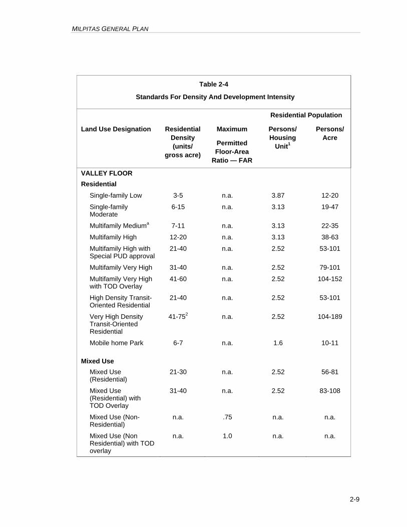
According to state law, the General Plan must establish standards of population density and building intensity for each land use classification. The General Plan expresses residential density as housing units and persons per gross acre, as established in Table 2-4 and the land use classifications that follow. Density ranges specified for each category are discrete and not cumulative. However, housing types are cumulative (i.e. single family units are permitted in areas designated for multifamily use), provided the overall development project falls within the stipulated density range. If a project’s density falls between the density ranges of separate designations, its density is to be rounded to the nearest whole number to determine if it conforms to the indicated General Plan density range. For example, in Multifamily Medium Density (7-11 units per gross acre) areas, a residential project would have to have a gross density of at least 6.5 units per acre and less than 12.5 units per acre in order to be in conformance with that General Plan designation.
For nonresidential uses, a maximum permitted ratio of gross floor area to site area (FAR) is specified. FAR is a broad measure of building bulk that controls both visual prominence and traffic generated. It can be clearly translated to a limit on building floor area in the Zoning Ordinance and is independent of the type of use occupying the building. The Zoning Ordinance will include provisions for reviewing and approving deviations from the FAR limitations for uses with low employee densities, such as wholesaling and distribution, or low peak-hour traffic generation, such as a hospital.
The density/intensity standards do not imply that development projects will be approved at the maximum density or intensity specified for each use. Zoning regulations consistent with General Plan policies and/or site conditions may reduce development potential within the ranges stated in the Plan.
Valley Floor
The following use descriptions apply to the Valley Floor portion of the Planning Area.
RESIDENTIAL
Residential densities are expressed as a range of housing units per gross acre of developable land, provided that at least one housing unit may be built on each existing legally-subdivided parcel designated for residential use. Second units permitted by local regulations (i.e. “granny flats”, “in-law units”), and state-mandated density bonuses for affordable housing are in addition to densities otherwise permitted.
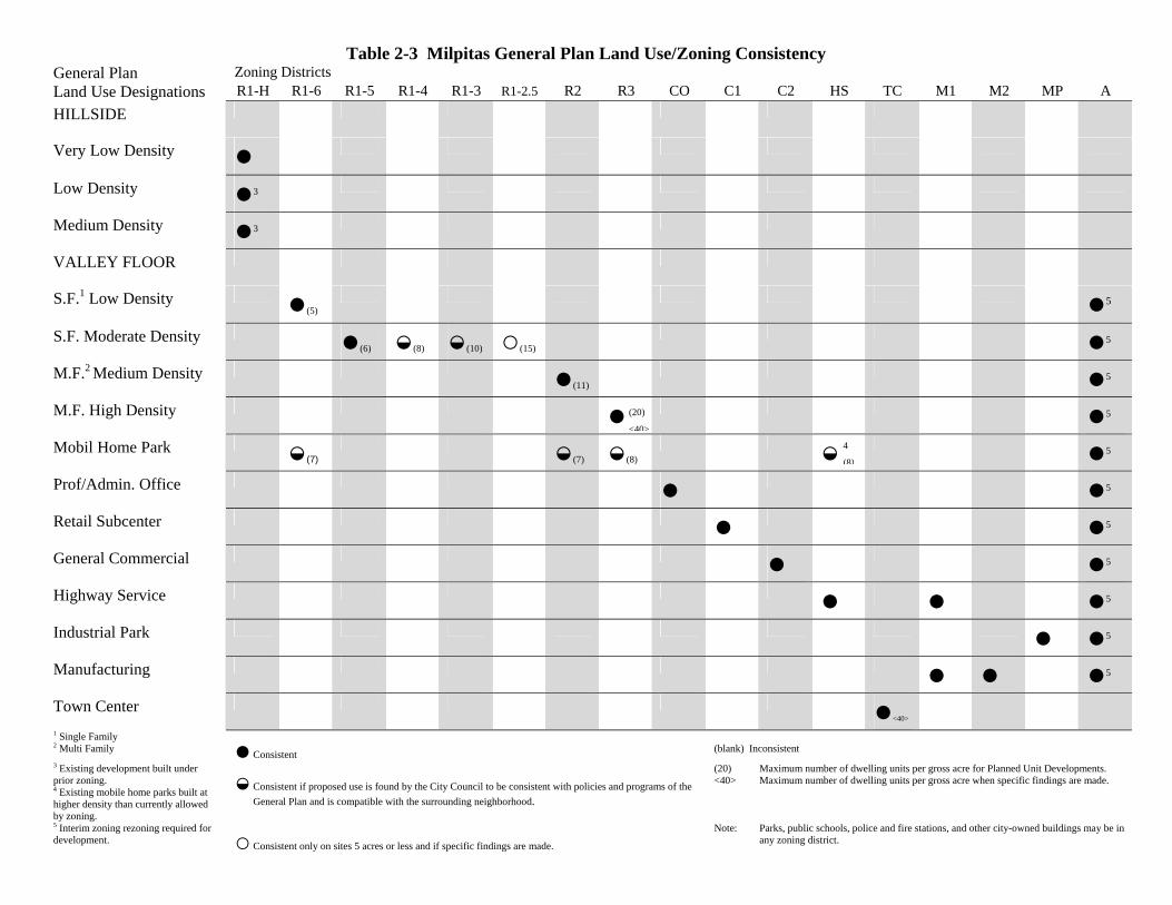
Table 2-3 Milpitas General Plan Land Use/Zoning Consistency General Plan Zoning Districts Land Use Designations R1-H R1-6 R1-5 R1-4 R1-3 R1-2.5 R2 R3 CO C1 C2 HS TC M1 M2 MP A HILLSIDE
Very Low Density ●
Low Density ●3
Medium Density ●3
VALLEY FLOOR
S.F.1 Low Density ●(5) ●5
S.F. Moderate Density ●(6) ◒(8) ◒(10) ○(15) ●5
M.F.2 Medium Density ●(11) ●5
M.F. High Density ● ●5
Mobil Home Park ◒(7) ◒(7) ◒(8) ◒ ●5
Prof/Admin. Office ● ●5
Retail Subcenter ● ●5
General Commercial ● ●5
Highway Service ● ● ●5
Industrial Park ● ●5
Manufacturing ● ● ●5
Town Center ●<40>
1 Single Family 2 Multi Family ● Consistent
(blank) Inconsistent
3 Existing development built under prior zoning. 4 Existing mobile home parks built at higher density than currently allowed by zoning.
◒ Consistent if proposed use is found by the City Council to be consistent with policies and programs of the General Plan and is compatible with the surrounding neighborhood.
(20) Maximum number of dwelling units per gross acre for Planned Unit Developments. <40> Maximum number of dwelling units per gross acre when specific findings are made.
5 Interim zoning rezoning required for development. ○ Consistent only on sites 5 acres or less and if specific findings are made.
Note: Parks, public schools, police and fire stations, and other city-owned buildings may be in any zoning district.
(20)
<40>
4
(8)
MILPITAS GENERAL PLAN
2-9
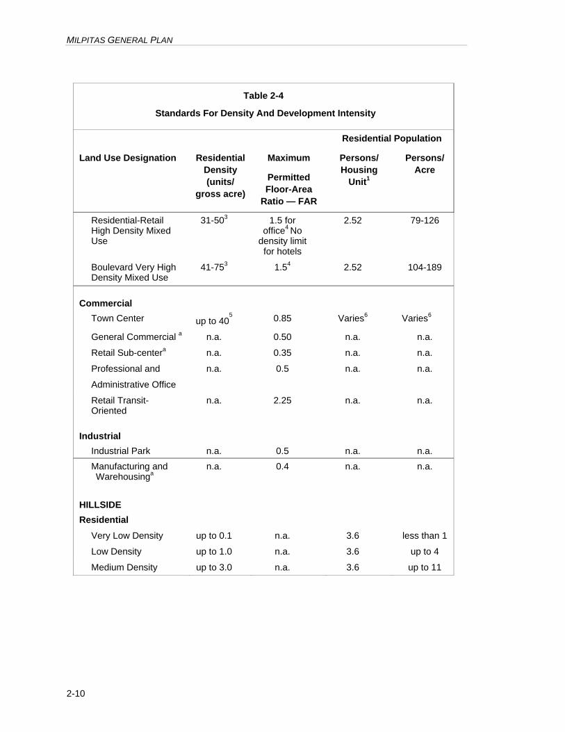
Table 2-4
Standards For Density And Development Intensity
Residential Population
Land Use Designation Residential Density (units/
gross acre)
Maximum
Permitted Floor-Area
Ratio — FAR
Persons/ Housing
Unit1
Persons/ Acre
VALLEY FLOOR Residential
Single-family Low 3-5 n.a. 3.87 12-20
Single-family Moderate
6-15 n.a. 3.13 19-47
Multifamily Mediuma 7-11 n.a. 3.13 22-35
Multifamily High 12-20 n.a. 3.13 38-63
Multifamily High with Special PUD approval
21-40 n.a. 2.52 53-101
Multifamily Very High 31-40 n.a. 2.52 79-101
Multifamily Very High with TOD Overlay
41-60 n.a. 2.52 104-152
High Density Transit-Oriented Residential
21-40 n.a. 2.52 53-101
Very High Density Transit-Oriented Residential
41-752 n.a. 2.52 104-189
Mobile home Park 6-7 n.a. 1.6 10-11 Mixed Use
Mixed Use (Residential)
21-30 n.a. 2.52 56-81
Mixed Use (Residential) with TOD Overlay
31-40 n.a. 2.52 83-108
Mixed Use (Non-Residential)
n.a. .75 n.a. n.a.
Mixed Use (Non Residential) with TOD overlay
n.a. 1.0 n.a. n.a.
MILPITAS GENERAL PLAN
2-10
Table 2-4
Standards For Density And Development Intensity
Residential Population
Land Use Designation Residential Density (units/
gross acre)
Maximum
Permitted Floor-Area
Ratio — FAR
Persons/ Housing
Unit1
Persons/ Acre
Residential-Retail High Density Mixed Use
31-503 1.5 for office4 No
density limit for hotels
2.52 79-126
Boulevard Very High Density Mixed Use
41-753 1.54 2.52 104-189
Commercial
Town Center up to 405 0.85 Varies6
Varies6
General Commercial a n.a. 0.50 n.a. n.a.
Retail Sub-centera n.a. 0.35 n.a. n.a.
Professional and
Administrative Office
n.a. 0.5 n.a. n.a.
Retail Transit-Oriented
n.a. 2.25 n.a. n.a.
Industrial
Industrial Park n.a. 0.5 n.a. n.a.
Manufacturing and Warehousinga
n.a. 0.4 n.a. n.a.
HILLSIDE Residential
Very Low Density up to 0.1 n.a. 3.6 less than 1
Low Density up to 1.0 n.a. 3.6 up to 4
Medium Density up to 3.0 n.a. 3.6 up to 11
MILPITAS GENERAL PLAN
2-11
Table 2-4
Standards For Density And Development Intensity
Residential Population
Land Use Designation Residential Density (units/
gross acre)
Maximum
Permitted Floor-Area
Ratio — FAR
Persons/ Housing
Unit1
Persons/ Acre
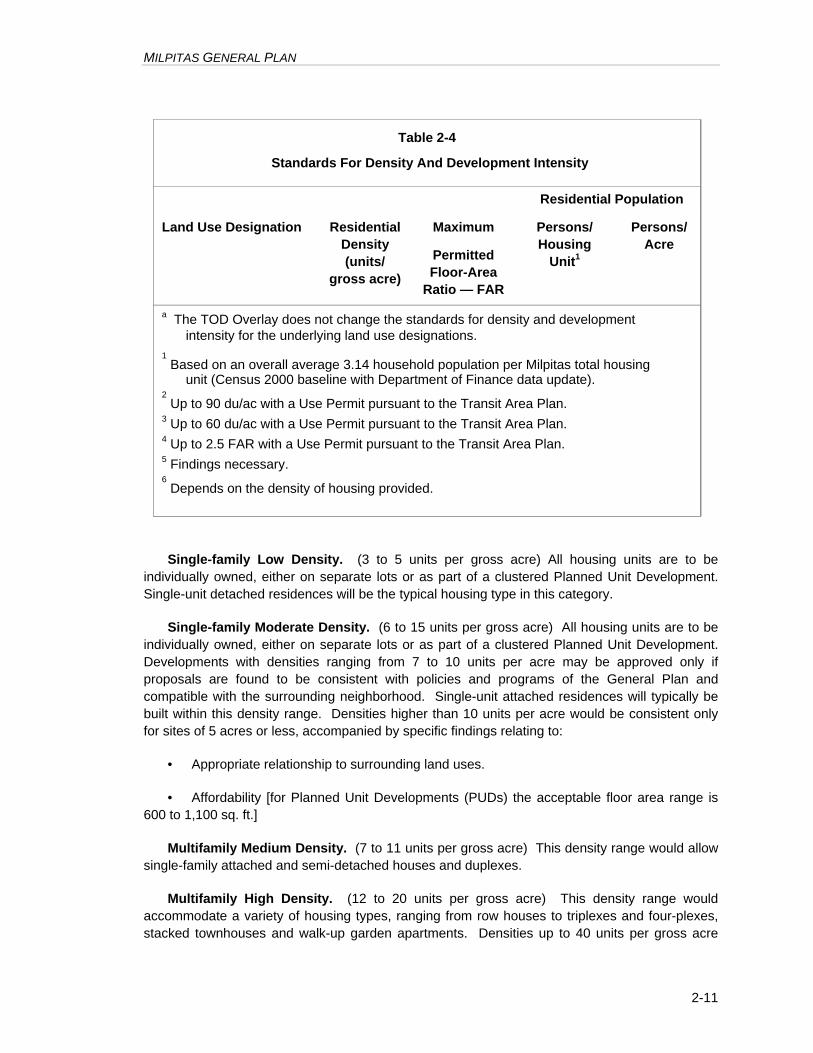
a The TOD Overlay does not change the standards for density and development intensity for the underlying land use designations.
1 Based on an overall average 3.14 household population per Milpitas total housing unit (Census 2000 baseline with Department of Finance data update).
2 Up to 90 du/ac with a Use Permit pursuant to the Transit Area Plan.
3 Up to 60 du/ac with a Use Permit pursuant to the Transit Area Plan. 4 Up to 2.5 FAR with a Use Permit pursuant to the Transit Area Plan. 5 Findings necessary. 6 Depends on the density of housing provided.
Single-family Low Density. (3 to 5 units per gross acre) All housing units are to be individually owned, either on separate lots or as part of a clustered Planned Unit Development. Single-unit detached residences will be the typical housing type in this category.
Single-family Moderate Density. (6 to 15 units per gross acre) All housing units are to be individually owned, either on separate lots or as part of a clustered Planned Unit Development. Developments with densities ranging from 7 to 10 units per acre may be approved only if proposals are found to be consistent with policies and programs of the General Plan and compatible with the surrounding neighborhood. Single-unit attached residences will typically be built within this density range. Densities higher than 10 units per acre would be consistent only for sites of 5 acres or less, accompanied by specific findings relating to:
• Appropriate relationship to surrounding land uses.
• Affordability [for Planned Unit Developments (PUDs) the acceptable floor area range is 600 to 1,100 sq. ft.]
Multifamily Medium Density. (7 to 11 units per gross acre) This density range would allow single-family attached and semi-detached houses and duplexes.
Multifamily High Density. (12 to 20 units per gross acre) This density range would accommodate a variety of housing types, ranging from row houses to triplexes and four-plexes, stacked townhouses and walk-up garden apartments. Densities up to 40 units per gross acre
MILPITAS GENERAL PLAN
2-12
may be permitted for proposals designed as Planned Unit Developments (PUDs) provided that the following criteria are met:
• Sewer and water service is sufficient to accommodate the proposal as well as other developments permitted by the General Plan. Any improvements to the sewer or water system that would be required to accommodate any such higher density proposals would be made conditions of project approval;
• Cumulative traffic, from the increased density and other existing or future projects, must not cause any street intersection to operate below Level of Service (LOS) E; and
• The design of such higher density projects will not have adverse shadow, view obstruction or loss of privacy impacts that are not mitigated to acceptable levels.
Multifamily Very High Density. (31 to 40 dwelling units per gross acre) This density range would accommodate a variety of housing types, ranging from row houses and townhouses to lofts and stacked flats with structured parking. Increased densities are permitted within the Transit Oriented Development overlay zone (TOD). Refer to page 2-15.
High Density Transit-Oriented Residential. A classification similar to the Midtown Plan’s “Multifamily Very High Density” designation, these properties are intended for medium-density residential neighborhoods further from BART, at the interior of sub-district neighborhoods. A minimum average gross density of 21 units per acre is required, up to a maximum of 40 units per acre. Residential and related uses are allowed, but not commercial uses.
Very High Density Transit-Oriented Residential. Intended to create residential districts near BART and light rail stations, this designation requires housing to be built at an average density of at least 41 units per gross acre, up to a maximum of 60 and 90 units per gross acre. Small local-serving commercial uses are permitted at the ground floor level, including retail, restaurants, and personal services uses.
Mobile-home Park. This is an overlay category that may be combined with Single-family Low Density, Multifamily Medium Density and Multifamily High Density Residential, or Highway Service classifications. Mobile home Park, along with accessory uses, is the permitted use. Maximum residential density would range from 6 to 7 units per gross acre when combined with the use classifications as follows:
In addition to the above-stipulated densities, one additional housing unit per gross acre may be permitted upon a finding by the Planning Commission that the proposed project is of a superior functional and aesthetic design based upon it exceeding adopted mobile home park development standards.
Mixed Use
Mixed Use. (Residential component: 21 to 30 units per gross acre; non-residential component: FAR of 0.75) This designation allows for commercial offices, retail and services, high density residential and public and quasi-public uses. Mixed-use buildings can contain a combination of residential and commercial uses. The intensity for the non-residential component is a maximum floor area ratio (FAR) of 0.75. The residential density is 21 to 30 units per gross

MILPITAS GENERAL PLAN
2-13
acre and is calculated separately from the non-residential component. Increased residential densities are permitted within the Transit Overlay District (TOD). Refer to page 2-15.
Residential – Retail High Density Mixed Use. This district is intended to be a true mixed use area with retail, restaurants, and services on the ground floor, and residential or office uses on the floors above. The residential density is a minimum average gross density of 31 units per acre and a maximum of between 40 and 60 units per gross acre. In addition, 200 square feet of retail or restaurant space is required per unit, using the minimum density (i.e. the requirement is based on the number of units required to meet the minimum density). Sites may be developed for office and hotel uses without residential development, although ground floor retail or restaurant square footage will still be required. For nonresidential projects, the minimum FAR ranges from 1.5 to 2.25. However there is no FAR limit for hotels. A FAR of 2.5 may be permitted on individual sites with approval of a conditional use permit by the Planning Commission.
Boulevard Very High Density Mixed Use. This classification is intended to provide high-density housing, retail, and employment along Montague Expressway with a landscaped boulevard character. Projects may include a wholly residential or non-residential concept or a project that integrates residential and non-residential uses vertically or horizontally.
Permitted uses include residential, office, commercial, and medical uses. Sites developed with a mix of uses, or non-residential uses, must adhere to the FAR maximum which ranges from 1.5 to 2.25. Residential projects shall have a minimum average gross density of 41 units per acre and can be built up to between 60 to 90 units per acre.
A FAR of 2.5 may be permitted on individual sites with approval of a conditional use permit by the Planning Commission. Special criteria would need to be met, including the following: (1) the proposed uses include a hotel or office uses that create substantial new jobs, and do not include residential uses; (2) the design of the project is on extremely high quality and is compatible with the scale of surrounding buildings; (3) there are no adverse traffic impacts beyond those studied in the Transit Area Plan EIR or the project will be required to mitigate such impacts individually; and (4) buildings do not shade public parks or plazas more than 30% between 10 AM and 3 PM as measured on March 15.
INSTITUTIONAL
The Institutional classification is for parcels owned by public agencies and intended to be accessed by the public. There are three institutional classifications:
1. Schools
2. Correctional Facility
3. Public Facilities
COMMERCIAL
Town Center. This designation provides for a variety of commercial, civic and residential uses appropriate to the Center's role as the functional and visual focus of Milpitas. The Town
MILPITAS GENERAL PLAN
2-14
Center is a meeting place and a market place, the home of commercial and professional firms, an entertainment area and a place for restaurants and hotels. Because of this unique and relatively intensive mix of activities, very high density residential developments (i.e., up to 40 units per acres) may be permitted within the Town Center because of the increased economic support the residents would offer to the commercial uses.
General Commercial. This classification provides for a wide range of retail sales, and personal and business services accessed primarily by the automobile. It includes commercial uses in which shopping may be conducted by people walking to several stores as in a center, and may include uses customarily of a single-purpose character served from an adjacently parked automobile.
Retail Sub-Center. This classification accommodates neighborhood shopping facilities that provide for convenience needs, such as groceries and minor hardgood purchases. The General Plan provides for nine sub-centers, between two and 20 acres in size, distributed throughout the City.
Professional and Administrative Office. This classification provides advantageous locations for medical, law, and similar services required to serve residents and businesses. While office uses can be located in all of the commercial districts, the Professional Administrative Office areas are solely for these uses.
Highway Service. This classification provides for motels, mobile home parks, and non-retail services such as car-rental offices. Eight highway service areas are designated on the General Plan Diagram, typically at the intersection of major streets and/or freeways.
INDUSTRIAL
Manufacturing. This classification encompasses a variety of light and heavy industrial activities, such as manufacturing, packaging, processing, warehousing and distribution, and ancillary support uses.
Industrial Park. This classification accommodates research, professional, packaging and distribution facilities in a park-like setting, free from noise, odor and other such nuisances.
HILLSIDE
The Hillside Area comprises approximately 6,000 acres generally east of Piedmont Road, Evans Road and the portion of North Park Victoria Drive north of Evans Road. The undeveloped portion of the Hillside Area is characterized by gentle to steep slopes, grassy terrain with some chaparral and trees, wildlife, geologically unstable areas, the Ed R. Levin County Regional Park, and a feeling of remoteness from the more urban portions of the City. These conditions warrant Plan proposals and use classifications that differ considerably from those for the Valley Floor Area.
To ensure safety and to preserve its natural ambiance, all development in the Hillside Area is to be of low-density rural residential nature. Three categories of residential uses are provided.
MILPITAS GENERAL PLAN
2-15
The Low and the Medium Density categories accommodate existing development; all new development is to be at a Very Low Density.
RESIDENTIAL
Residential densities are per gross acre of developable land provided that at least one housing unit may be built on each existing parcel designated for residential use. Densities outlined in the classifications are maximums for the classifications; these decrease with increase in slope as outlined in the classifications and defined in detail in the City’s Zoning Ordinance. The City may further reduce the permitted density on a site if such a reduction is necessary or appropriate for reasons of site conditions, access, views or geologic hazards. Second units permitted by local regulations and state access-mandated density bonuses for affordable housing are in addition to densities otherwise permitted.
Very Low Density. The maximum permitted density for this classification is one dwelling unit per ten gross acres. The maximum density decreases with increase in slope until 80 acres per housing unit is required for land with an average slope of 50 percent or greater. This designation includes most of the Hillside Area.
Low Density. The maximum density for this classification is 1.0 housing unit per gross acre. This density decreases with increase in slope until ten acres of land are required per housing unit for sites with an average slope of 27 percent or more. Three relatively small areas of the Hillside (representing prior developments) are shown on the General Plan Diagram with this designation.
Medium Density. The maximum density for this classification is approximately 3.0 units per gross acre on level land and decreases with increasing slope until ten acres of land are required per unit for sites with an average slope of approximately 27 percent or more. Areas designated as Medium Density (all existing) include:
• Development along the base of the hillside area;
• Summitpointe residential and golf course;
• Calaveras Ridge PUD; and
• The Country Club Estates.
OVERLAY ZONES
Overlay zones are established in areas with distinct characteristics to have special development standards or guidelines beyond those identified in the underlying land use designation to carry out a vision or goal.
Transit Oriented Development (TOD) Overlay Zone
The Transit Oriented Development (TOD) Overlay Zones are located near transit stations, and are applicable to land generally located within a 2,000 foot walking distance from a Light Rail Station or future BART station. Development within the TOD overlay zone is subject to special requirements regarding development density, parking, mix of uses, and transit supportive design features.
MILPITAS GENERAL PLAN
2-16
The south Midtown TOD increases densities in the Multifamily-Very High Density designation to a range of 41 to 60 dwelling units per gross acre. The north Midtown TOD increases densities in the Mixed Use designation to a range of 31 to 40 dwelling units per gross acre.
Gateway Office Overlay Zone
The Gateway Office Overlay Zone is located in areas that are well-suited for a ‘gateway’ higher intensity office development. This overlay zone allows office developments to be developed to an intensity of FAR 1.5 for Class A office only; not for retail or other office buildings.
Recreation and Entertainment Overlay
The purpose of the Recreation and Entertainment (-RE) Overlay District is to encourage the interaction between commercial and entertainment uses to create a destination that attracts visitors to Milpitas, which in turn, enhances retail spending opportunities. The overlay would expand the type of recreation and entertainment uses that could be allowed with a conditional use permit in the non-residential (C2, HS, M1, and MP) zoning districts covered by the district. Such uses include but not limited to conference centers, movie theatres, nightclubs, indoor recreational facilities, etc.
High Rise Overlay
The purpose of the High Rise Overlay is intended to be a special district to allow greater building height and density at strategic locations to frame major City gateways and provide unique housing, shopping and employment opportunities. This overlay would allow between 60-150 dwelling units per gross acre and is intended for areas that are well suited for taller, high density mixed-use buildings located along freeways or expressways.
MILPITAS GENERAL PLAN
2-17
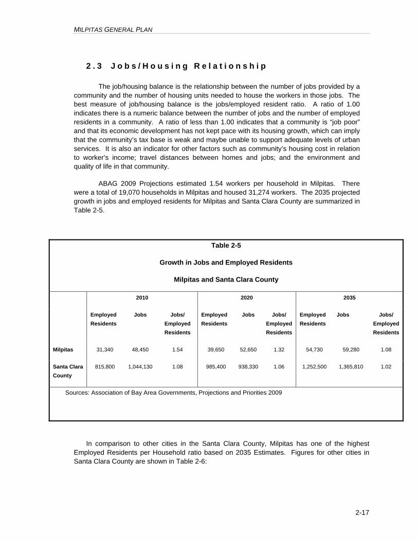
2 . 3 J o b s / H o u s i n g R e l a t i o n s h i p
The job/housing balance is the relationship between the number of jobs provided by a community and the number of housing units needed to house the workers in those jobs. The best measure of job/housing balance is the jobs/employed resident ratio. A ratio of 1.00 indicates there is a numeric balance between the number of jobs and the number of employed residents in a community. A ratio of less than 1.00 indicates that a community is “job poor” and that its economic development has not kept pace with its housing growth, which can imply that the community’s tax base is weak and maybe unable to support adequate levels of urban services. It is also an indicator for other factors such as community’s housing cost in relation to worker’s income; travel distances between homes and jobs; and the environment and quality of life in that community.
ABAG 2009 Projections estimated 1.54 workers per household in Milpitas. There were a total of 19,070 households in Milpitas and housed 31,274 workers. The 2035 projected growth in jobs and employed residents for Milpitas and Santa Clara County are summarized in Table 2-5.
Table 2-5
Growth in Jobs and Employed Residents
Milpitas and Santa Clara County
2010 2020 2035
Employed Residents
Jobs Jobs/ Employed Residents
Employed Residents
Jobs Jobs/ Employed Residents
Employed Residents
Jobs Jobs/ Employed Residents
Milpitas 31,340 48,450 1.54 39,650 52,650 1.32 54,730 59,280 1.08
Santa Clara County
815,800 1,044,130 1.08 985,400 938,330 1.06 1,252,500 1,365,810 1.02
Sources: Association of Bay Area Governments, Projections and Priorities 2009
In comparison to other cities in the Santa Clara County, Milpitas has one of the highest Employed Residents per Household ratio based on 2035 Estimates. Figures for other cities in Santa Clara County are shown in Table 2-6:
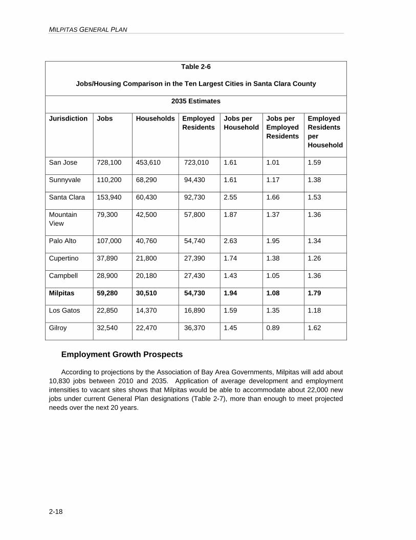
MILPITAS GENERAL PLAN
2-18
Table 2-6
Jobs/Housing Comparison in the Ten Largest Cities in Santa Clara County
2035 Estimates
Jurisdiction Jobs Households Employed Residents
Jobs per Household
Jobs per Employed Residents
Employed Residents per Household
San Jose 728,100 453,610 723,010 1.61 1.01 1.59
Sunnyvale 110,200 68,290 94,430 1.61 1.17 1.38
Santa Clara 153,940 60,430 92,730 2.55 1.66 1.53
Mountain View
79,300 42,500 57,800 1.87 1.37 1.36
Palo Alto 107,000 40,760 54,740 2.63 1.95 1.34
Cupertino 37,890 21,800 27,390 1.74 1.38 1.26
Campbell 28,900 20,180 27,430 1.43 1.05 1.36
Milpitas 59,280 30,510 54,730 1.94 1.08 1.79
Los Gatos 22,850 14,370 16,890 1.59 1.35 1.18
Gilroy 32,540 22,470 36,370 1.45 0.89 1.62
Employment Growth Prospects
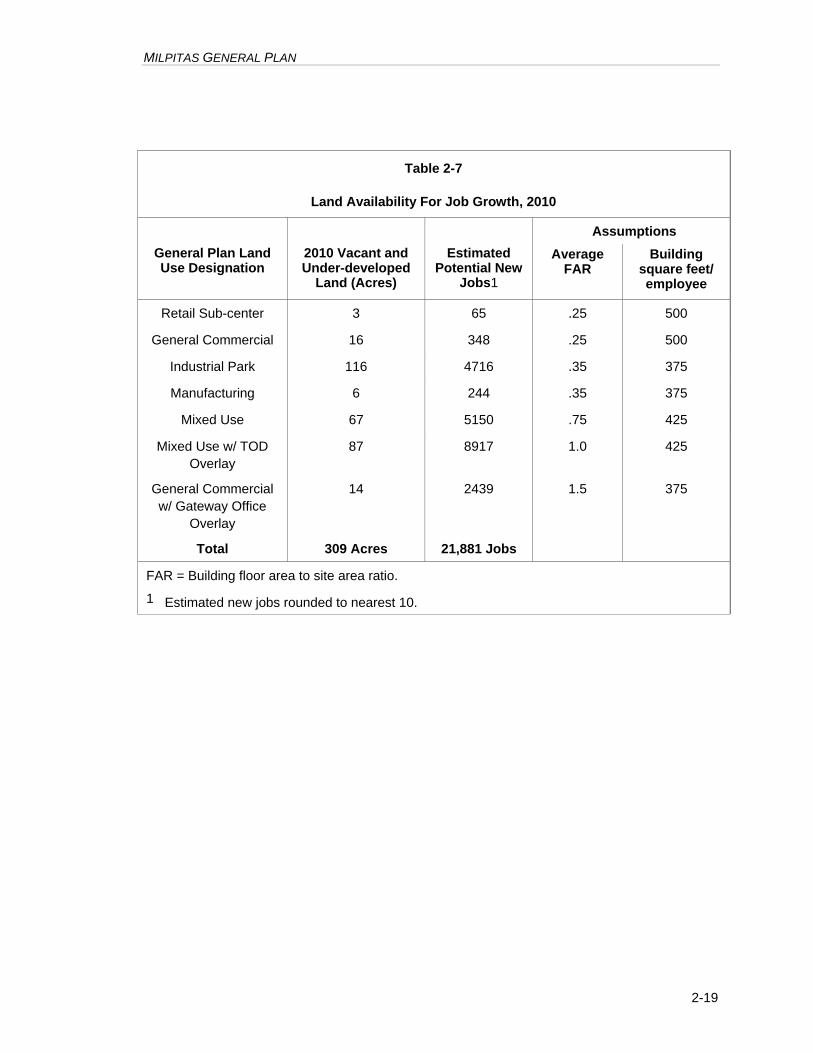
According to projections by the Association of Bay Area Governments, Milpitas will add about 10,830 jobs between 2010 and 2035. Application of average development and employment intensities to vacant sites shows that Milpitas would be able to accommodate about 22,000 new jobs under current General Plan designations (Table 2-7), more than enough to meet projected needs over the next 20 years.
MILPITAS GENERAL PLAN
2-19
Table 2-7
Land Availability For Job Growth, 2010
Assumptions
General Plan Land Use Designation
2010 Vacant and Under-developed
Land (Acres)
Estimated Potential New
Jobs1
Average FAR
Building square feet/ employee
Retail Sub-center 3 65 .25 500
General Commercial 16 348 .25 500
Industrial Park 116 4716 .35 375
Manufacturing 6 244 .35 375
Mixed Use 67 5150 .75 425
Mixed Use w/ TOD Overlay
87 8917 1.0 425
General Commercial w/ Gateway Office
Overlay
14 2439 1.5 375
Total 309 Acres 21,881 Jobs
FAR = Building floor area to site area ratio.
1 Estimated new jobs rounded to nearest 10.
MILPITAS GENERAL PLAN
2-20
2 . 4 S c h o o l s
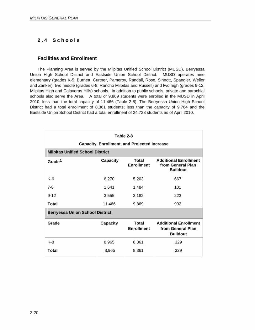
Facilities and Enrollment
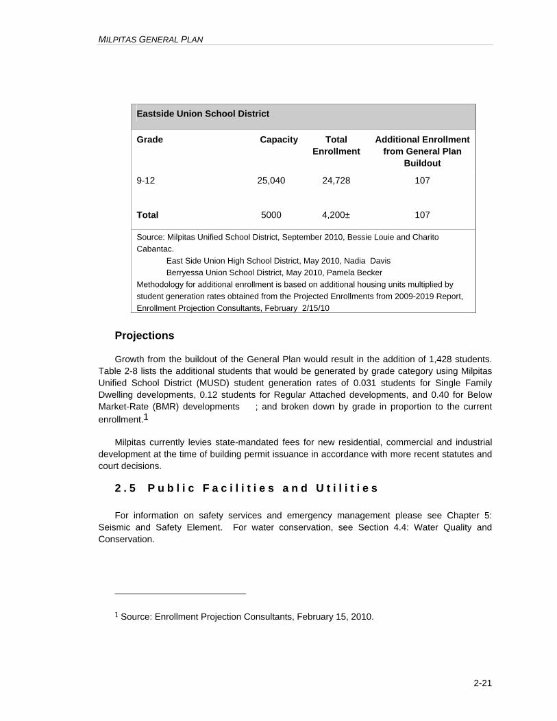
The Planning Area is served by the Milpitas Unified School District (MUSD), Berryessa Union High School District and Eastside Union School District. MUSD operates nine elementary (grades K-5; Burnett, Curtner, Pameroy, Randall, Rose, Sinnott, Spangler, Weller and Zanker), two middle (grades 6-8; Rancho Milpitas and Russell) and two high (grades 9-12; Milpitas High and Calaveras Hills) schools. In addition to public schools, private and parochial schools also serve the Area. A total of 9,869 students were enrolled in the MUSD in April 2010; less than the total capacity of 11,466 (Table 2-8). The Berryessa Union High School District had a total enrollment of 8,361 students; less than the capacity of 9,764 and the Eastside Union School District had a total enrollment of 24,728 students as of April 2010.
Table 2-8
Capacity, Enrollment, and Projected Increase
Milpitas Unified School District
Grade1 Capacity Total Enrollment
Additional Enrollment from General Plan
Buildout
K-6 6,270 5,203 667
7-8 1,641 1,484 101
9-12 3,555 3,182 223
Total 11,466 9,869 992
Berryessa Union School District
Grade Capacity
Total Enrollment
Additional Enrollment from General Plan
Buildout
K-8 8,965 8,361 329
Total 8,965 8,361 329
MILPITAS GENERAL PLAN
2-21
Eastside Union School District
Grade Capacity
Total Enrollment
Additional Enrollment from General Plan
Buildout
9-12 25,040 24,728 107
Total 5000 4,200± 107
Source: Milpitas Unified School District, September 2010, Bessie Louie and Charito Cabantac. East Side Union High School District, May 2010, Nadia Davis Berryessa Union School District, May 2010, Pamela Becker Methodology for additional enrollment is based on additional housing units multiplied by student generation rates obtained from the Projected Enrollments from 2009-2019 Report, Enrollment Projection Consultants, February 2/15/10
Projections
Growth from the buildout of the General Plan would result in the addition of 1,428 students. Table 2-8 lists the additional students that would be generated by grade category using Milpitas Unified School District (MUSD) student generation rates of 0.031 students for Single Family Dwelling developments, 0.12 students for Regular Attached developments, and 0.40 for Below Market-Rate (BMR) developments ; and broken down by grade in proportion to the current enrollment.1
Milpitas currently levies state-mandated fees for new residential, commercial and industrial development at the time of building permit issuance in accordance with more recent statutes and court decisions.
2 . 5 P u b l i c F a c i l i t i e s a n d U t i l i t i e s
For information on safety services and emergency management please see Chapter 5: Seismic and Safety Element. For water conservation, see Section 4.4: Water Quality and Conservation.
1 Source: Enrollment Projection Consultants, February 15, 2010.
MILPITAS GENERAL PLAN
2-22
Government Facilities
The Civic Center (consisting of City Hall, Community Center and Senior Center) is adjacent to the Town Center. The library is located on southwest corner of North Main Street and Weller Avenue near Calaveras Boulevard overpass. The Police Station and Corporation Yard are located on the west side of North Milpitas Boulevard. There are four fire stations located throughout the Valley Floor Area. The locations of these City facilities, as well as the County’s Elmwood Correctional Facility on Abel Street, are indicated on the General Plan Diagram.
Water Supply
The City receives water from the San Francisco Water Department (SFWD) through the Hetch-Hetchy system by connections on two of the four local aqueducts that transport water from mountain reservoirs to San Francisco and the Peninsula. While the SFWD aqueduct is able to meet the City's demand, the City's 1980 Water Master Plan concluded that it would be more cost effective for the City to obtain some of its water from the Santa Clara Valley Water District (SCVWD). As a result, industrial areas in the southwestern part of the City have since August 1993 been receiving water from the SCVWD.
The 2009/2010 average water consumption in the City was approximately 11,500 acre feet per year. The projected domestic water purchases for 2010/2011 is 10,500 acre feet per year. The City’s current Water Master Plan was adopted in Spring 2010.
Wastewater Services
The San Jose/Santa Clara Water Pollution Control Plant (WPCP), the wastewater treatment facility for the City, is located in San Jose. It is a tertiary regional facility serving San Jose, Santa Clara, Milpitas, West Valley Sanitation District, Cupertino Sanitary District, County Sanitary District 2-3, Burbank Sanitary District, and the Sunol Sanitary District. Milpitas wastewater service area is contiguous with the City boundaries.
Capacity and Discharge. In 2009/2010, the City discharged 8.4 million gallons per day (mgd) and is contractually limited to a flow of 14.25 mgd. The dry weather flow rate was 7.2 mgd in 2010/2011. The WPCP has a dry-weather total capacity of 167 mgd, and a current average daily flow of approximately 121 mgd. There are no plans to increase the capacity of the WPCP. To mitigate a discharge-limit cap, conditions to WPCP's National Pollution Discharge Elimination System discharge permit have been imposed (see Section 4.4). The WPCP staff is preparing a master plan to establish a 30-year plan for equipment and process upgrades.
Current Programs. In order to allow the WPCP to meet the more stringent discharge requirements into the Bay, Milpitas is participating in water conservation programs and plans to divert flows to reclamation systems. Recycled water to supplement potable irrigation water became available in 2000. Future recycled water uses include industrial process, cooling towers, and dual plumbing of non-residential buildings.
MILPITAS GENERAL PLAN
2-23
The City completed an inflow and infiltration sewer remedial program in 1989. The City also updated its sewer master plan in May 2010.
MILPITAS GENERAL PLAN
2-24
2 . 6 L a n d U s e P r i n c i p l e s a n d P o l i c i e s
a. Land Use
Guiding Principles
2.a-G-1 Maintain a land use program that balances Milpitas' regional and local roles by providing for a highly amenable community environment and a thriving regional industrial center.
2.a-G-2 Maintain a relatively compact urban form. Emphasize mixed-use development to the extent feasible, to achieve service efficiencies from compact development patterns and to maximize job development and commercial opportunities near residential development.
2.a-G-3 Provide for a variety of housing types and densities that meet the needs of individuals and families.
2.a-G-4 The Town Center will be the “heart” of Milpitas’ civic, cultural, business, and professional life.
2.a-G-5 A park-like setting will be created by a series of local parks, school sites, trails, and a greenway system laced throughout all living areas.
2.a-G-6 Implement the Midtown Specific Plan goals, policies and development standards and guidelines to create a mixed-use community that includes high-density, transit-oriented housing and a central community ‘gathering place’ while maintaining needed industrial, service and commercial uses.
2.a-G-7 When considering development proposals, seek “community benefit”, such as upgrading infrastructure facilities, constructing new infrastructure facilities, and funding contributions to programs.
MILPITAS GENERAL PLAN
2-25
2.a-G-8 The City should consider a long term approach to managing its income/job generating lands and the impacts of development on public services.
2.a-G-9 The city should make land use decisions that improve the City’s fiscal condition. Manage the City’s future growth in an orderly, planned manner that is consistent with the City’s ability to provide efficient and economical public services, to maximize the use of existing and proposed public facilities, and to achieve equitable sharing of the cost of such services and facilities.
2.a-G-10
Consider long-term planning and strong land use policy in managing the City’s fiscal position.
2.a-G-11
Promote land use policy and implementation actions that improve the City’s fiscal sustainability. Maintain and enhance the City’s projected total net revenue through amendments made to the General Plan. Discourage proposed re-zonings or other discretionary land use actions that could significantly diminish revenue to the City or significantly increase the City’s service costs to the City without offsetting increases in revenue.
Implementing Policies
Development Intensity
2.a-I-1 New developments should not exceed the building intensity limits established in the General Plan.
Housing density standards consistent with the General Plan are already established in the Zoning Ordinance. Limits on development intensity are required by state law.
2.a-I-2 Land use conversions from employment/sales tax generation properties to residential shall only be considered once there is 80% buildout in the Midtown and Transit Area Specific Plans.
MILPITAS GENERAL PLAN
2-26
Growth and Expansion
2.a I-2 Promote development within the incorporated limits which acts to fill-in the urban fabric rather than providing costly expansion of urban services into outlying areas.
2.a I-2.1 Maintain an Urban Growth Boundary in the hillside area, as shown on the General Plan Land Use Map, that shall be effective until December 31, 2018 and, except as otherwise provided below, shall not be moved until that time.
A. City Services Prohibited in Area Outside the Urban Growth Boundary and Outside the City Limits: The City shall not process, approve or authorize construction or provision of any City service or City service extension to any property or people in that area located both outside of the Urban Growth Boundary and outside of the city limits of the City of Milpitas, except as expressly provided in this Policy 2.a I-2.1A. “City service” means any water, sanitary sewer, storm drain, flood control, road maintenance, sidewalk maintenance, police, fire or emergency medical service, including construction of related infrastructure that the City, its agents, its departments, or its contractors, provides to any property or people within the City limits. The City may provide a City service or City service extension to property or people outside of the Urban Growth Boundary only if:
1. Declared Public Emergency: The City Council declares a local emergency pursuant to Government Code § 8630 et seq. or Milpitas Municipal Code Title V, Chapter V-1 as they presently exist or may be amended in the future and the City Council finds, based on substantial evidence, that: (1) the extension or provision of service on a temporary basis is necessary to ensure public safety and (2) the extension or provision of service is for a specified limited time period;
MILPITAS GENERAL PLAN
2-27
2. Urgent Public Health or Safety Concern Affecting Existing Development: The City Council finds, based on substantial evidence, that: (1) an urgent public health or safety concern exists; (2) an independent, certified professional engineer approved by the City has concluded that the only economically justifiable solution to that public health or safety concern is to provide or extend City service; (3) on or before November 3, 1998, the legal parcel affected by that public health or safety concern had either a vested right to develop an approved land use or an approved and recorded final subdivision map pursuant to which residential units had been constructed within said subdivision; and 4) the applicant for the provision or extension of such City service has agreed to pay for its proportionate share of the service or service extension costs including, but not limited to, any engineering, design, inspection, land acquisition or review or other capital or operating costs incurred by the City. Any City service extension constructed under this Policy 2.a I-2.1A.(ii) shall be constructed in accordance with Section XI-1-7 of the Milpitas Municipal Code (regarding developer installation of improvements);
3. Parks and Open Space: The City Council finds, based on substantial evidence, that: (1) the property is operated as park or open space for the benefit of the general public and owned by either a private open-space trust or a government agency, authority, or district; (2) there would be minimal alteration (e.g. trails and fire roads) of the natural land forms as a result of any land use approval or modification; and (3) the property either will be used exclusively for passive recreational uses consistent with the rural character and indigenous plant and animal species of the hillsides, or contains a designated historic building(s) or setting that will be used for a purpose related to the historic significance of the site. Any property that is extended or provided City service under this Policy 2.a I-2.1.A.(i) shall not be used as golf course, ball field, ball court, amphitheater, amusement park, gymnasium or auditorium; or
4. Mutual Aid Agreements with Other Public Agencies: The City Council finds, based on substantial evidence, that: (1) the City services to be provided are limited to police, fire or emergency medical services, (2) such services are provided pursuant to a written agreement between the City of Milpitas and another public agency, (3) the agreement provides mutual benefits to both the City of Milpitas and the other agency to the agreement, and (4) the agreement benefits all or substantially all of the residents of the City of Milpitas.
MILPITAS GENERAL PLAN
2-28
B. Limited City Services Available in Areas Outside the Urban Growth Boundary and Within the City Limits: The City may provide police, fire or emergency medical service to any property or people in that area located both outside of the Urban Growth Boundary and within the city limits of the City of Milpitas. “City police, fire or emergency medical service” means any police, fire or emergency medical service, including construction of directly related infrastructure [except new stations] that the City, its departments, agents or contractors provides to any property or people within the City limits. Other than police, fire and emergency medical services specified herein, the City shall not process, approve or authorize construction or provision of any City service or City service extension to any property or people in that area located both outside of the Urban Growth Boundary and within the city limits of the City of Milpitas, except as expressly provided in this Policy 2.a I-2.1A. For purposes of this section, “City service” means any water, sanitary sewer, storm drain, flood control, road maintenance, sidewalk maintenance, including construction of related infrastructure that the City, its agents, its departments, or its contractors, provides to any property or people within the City limits. Notwithstanding any prohibition provided in this paragraph, the City may continue to maintain and/or repair that portion of Calaveras Road within the City limits and outside of the Urban Growth Boundary.
C. Amendments to the Urban Growth Boundary: Until December 31, 2018, the Urban Growth Boundary may only be amended as follows:
1. The Urban Growth Boundary may be amended by a vote of the People of the City of Milpitas;
2. To comply with state law regarding the provision of housing for all economic segments of the community, the City Council may amend the Urban Growth Boundary to accommodate lands designated or to be designated for residential uses. No more than 3 acres of land may be brought within the Urban Growth Boundary for this purpose in any calendar year. Land added to the Urban Growth Boundary pursuant to this section must be contiguous to land already within the Urban Growth Boundary. Such amendment may be adopted only if the City Council makes all of the following findings, based on substantial evidence:
a That the land is to be included within the Urban Growth Boundary not designated as existing regional parks in the Santa Clara County General Plan adopted December 20, 1994, as amended through August 3, 1998; and
b. That the land is immediately adjacent to (i) the existing Urban Growth Boundary, and (ii) existing serviceable water and sewer connections;
c. That the proposed development will consist of primarily low and very low income housing pursuant to the Housing Element of this General Plan; and
MILPITAS GENERAL PLAN
2-29
d. hat there is no existing residentially designated land within the Urban Growth Boundary to accommodate the proposed development and it is not reasonably feasible to accommodate the proposed development by redesignating lands inside the Urban Growth Boundary for low and very low income housing; and
e. That the proposed development is necessary to comply with state law requirements for provision of low and very low income housing and the area of land within the proposed development will not exceed the minimum necessary to comply with state law; or
3. The City Council may amend the Urban Growth Boundary if it makes both of the following findings:
a. The application of any aspect of the Urban Growth Boundary above would constitute an unconstitutional taking of a landowner’s property; and
b. That the amendment and associated land use designation under consideration by the City Council will allow additional land uses approved by the City Council only to the minimum extent necessary to avoid said unconstitutional taking of the landowner’s property.
D. Review of the Urban Growth Boundary: In 2015, prior to its expiration in 2018, the City shall begin a comprehensive review of the Urban Growth Boundary.
2.a I-2.2 Not later than 45 days after approval of this General Plan Amendment, the City shall take all necessary actions to apply for and request that the Santa Clara County Local Agency Formation Commission (“SC LAFCO”) relocate the Urban Service Area boundary so that it is coterminous with the Urban Growth Boundary. The City shall take all actions within the scope of its jurisdiction to support and facilitate SC LAFCO’s action regarding the City’s request to relocate the Urban Service Area Boundary.
Economic Development
2.a-I-3 Encourage economic pursuits which will strengthen and promote development through stability and balance.
MILPITAS GENERAL PLAN
2-30
2.a-I-4 Publicize the position of Milpitas as a place to carry on compatible industrial and commercial activities with special emphasis directed toward the advantages of the City’s location to both industrial and commercial use.
2.a-I-5 Maintain policies that promote a strong economy which provides economic opportunities for all Milpitas residents within existing environmental, social fiscal and land use constraints.
2.a-I-6 Endeavor to maintain a balanced economic base that can resist downturns in any one economic sector.
2.a-I-7 Provide opportunities to expand employment, participate in partnerships with local business to facilitate communication, and promote business retention.
2.a-I-8
Establish redevelopment projects to secure funds that can be used to attract commercial, industrial, and residential development in order to eliminate blight and improve an area.
2.a-I-9 Prohibit encroachment of incompatible uses into industrial lands, and prohibit non-industrial uses which would result in the imposition of additional operational restrictions and/or mitigation requirements on industrial users due to land use incompatibility issues.
2.a-I-10 Maintain an inventory of industrial lands and periodically assess the condition, type, and amount of industrial land available to meet projected demands.
MILPITAS GENERAL PLAN
2-31
2.a-I-11 Encourage supportive and compatible commercial and office uses in industrial areas designated for those uses. In areas reserved for industrial uses, only limited ancillary and incidental commercial uses, such as small eating establishments, may be permitted when such are of a scale and design providing support only to the needs of businesses and their employees in the immediate industrial area.
2.a-I-12 Consider conversion from one employment land use to another, where the conversion would retain or expand employment capacity and revenue generation, particular for intensification on-site if the proposed conversion would result in a net increase in revenue generation.
2.a-I-13 When considering land use conversions from commercial or industrial lands to residential, the City should contemplate substantial economic benefit through negotiable development agreements with contributions towards the Economic Development Corporation to spur economic development.
Land Use Compatibility
2.a-I-14 When new uses are proposed in proximity to existing industrial uses, incorporate conditions upon the new use to minimize its negative impacts on existing nearby land uses and to promote the health and safety of individuals at the new development site.
Prohibit social organization uses within industrial areas. Consider these uses in other areas in the City.
Fiscally Beneficial Land Use
2.a-I-15 Maintain and expand the total amount of land with industrial designations. Do not add overlays or other designations that would allow non-industrial, employment uses within industrially designated areas.
MILPITAS GENERAL PLAN
2-32
Community Identity
2.a-I-16 Preserve and maintain the historical landmarks of Milpitas and its physical setting so the residents will recognize they are a part of a distinctive and dynamic community.
Detailed policies related to historic preservation are in Section 4.9.
2.a-I-17 Foster community pride and growth through beautification of existing and future development.
Residential Development
2.a-I-18 Create a park-like quality for all residential areas through the PUD process and the judicious siting of parks, schools and greenways throughout those areas.
2.a-I-119
Use zoning for new residential developments to encourage a variety and mix in housing types and costs.
This policy is also in the Housing Element
2.a-I-20 Geographically disperse similar development types throughout the community so that denser districts are not concentrated within a single area of the City.
This policy is also in the Housing Element
Hillside Development
(For policies relating to crestline and scenic resources protection, see Section 4.9: Scenic Resources and Routes: for safety issues related to hillside development, See Section 5.5: Seismic and Geologic Hazards.)
2.a-I-21 Encourage clustered housing and planned unit developments to reduce the visual impact as viewed from the Valley Floor, preserve natural topographic features, avoid geologic hazards and provide open space in residential areas.
2.a-I-22 Where planned unit developments are not undertaken, protect major portions of the subdivision with open space easements.
MILPITAS GENERAL PLAN
2-33
2.a-I-23 Limit new development in the Hillside Area to only to Very Low Density Residential, open space and park uses.
2.a-I-24 In order to preserve the natural topography of the hillside, limit densities otherwise permitted in the hillside according to a slope-density formula.
Section XI-10-45.03 of the Zoning Ordinance elaborates upon these requirements.
2.a-I-25 To ensure that development in the foothills is in keeping with the natural character of the hillside, and that views are protected, require city review and approval of all proposed development or major alterations to existing development in the hillside. As part of the review, ensure that:
• landscaping is of a type indigenous to the area;
• that building designs, materials and colors blend with the environment; and
• grading is minimized and contoured to preserve the natural terrain quality.
Section XI-10-45.09 of the Zoning Ordinance prescribes the review requirements in detail.
2.a-I-26 Establish crestline protection areas around the ridges which will ensure that buildings and grading west of the first ridge do not visually penetrate a band of land that lies 100 feet vertically below the apparent crestline when viewed from certain specific sites on the valley floor and that no structures just east of the crestline extend above the crestline sight line.
Town Center
2.a-I-27 Develop the Town Center as an architecturally distinctive mixed-use complex which will add to Milpitas' identity and image.
2.a-I-28 Require development in the Town Center to conform to the adopted design principles/requirements of the Milpitas Redevelopment Agency.
MILPITAS GENERAL PLAN
2-34
Midtown
2.a-1-29 Develop the Midtown area, as shown on the Midtown Specific Plan, as an attractive and economically vital district that accommodates a mixture of housing, shopping, employment, entertainment, cultural and recreational activities organized within a system of landscaped boulevards, streets and pedestrian/bicycle linkages.
2.a-1-30 Require development in the Midtown area to conform to the adopted design guidelines/requirements contained in the Midtown Specific Plan.
Transit Area
2.a 1-31 Develop the Transit area, as shown on the Transit Area Plan, as attractive, high density, urban neighborhoods with a mix of land uses around the light rail stations and the future BART station. Create pedestrian connections so that residents, visitors, and workers will walk, bike, and take transit. Design streets and public spaces to create a lively and attractive street character, and a distinctive identity for each sub-district.
2.a 1-32 Require development in the Transit area to conform to the adopted design guidelines/requirements contained in the Transit Area Plan.
MILPITAS GENERAL PLAN
2-35
Child Care
2.a-I-33 Encourage the establishment of day care facilities consistent with State standards, including the issuance of use permits for large day care facilities where compatible with surrounding neighborhoods and commercial uses, particularly in public facilities such as community centers, churches, schools and in employment centers and large housing developments.
2.a-I-34 Consider zoning code modifications to encourage day care facilities through development bonuses, flexible parking regulations, design provisions for modular units, and similar incentives.
2.a-I-35 Collect and disseminate information regarding existing day care facilities and programs to major employees.
MILPITAS GENERAL PLAN
2-36
Land Use Element Revision
2.a-I-36 Undertake a comprehensive revision of the Land Use Element, including the General Plan Diagram prior to the next five year comprehensive review of the General Plan.
b. Jobs/Housing Relationship
Guiding Principle
2.b-G-1 Support jobs/housing balance programs at the local and regional scale intended to reduce the distance needed to commute.
Implementing Policies
2.b-I-1 Monitor the jobs/housing balance within the City on an annual basis.
2.b-I-2 Consider locating housing in close proximity to industrial developments where they can be served by existing city services and facilities.
This policy is also in the Housing Element
2.b-I-3 Provide housing opportunities in Milpitas by meeting the City's regional fair-share housing obligations.
2.b-I-4 Support jobs/housing balance programs at the regional scale that reduce in- and out-commuting from Milpitas.
Despite the presence of a greater number of jobs than employed residents, only one-fifth of workers living in Milpitas actually work in the City. Local programs to balance jobs and housing would be effective only if they are part of an overall regional strategy.
MILPITAS GENERAL PLAN
2-37
c. Schools
Guiding Principle
2.c-G-1 Provide adequate school facilities for the City's residents.
The quality of educational programs and facilities is an important component of the community’s quality of life and the desirability of the City to new residents and businesses.
Implementing Policies
2.c-I-1 Continue working with MUSD, Berryessa Union High School District, and East Side Union School District in its update of the comprehensive facilities plan and to ensure adequate provision of school facilities.
2.c-I-2 Locate future school sites on the General Plan Diagram if and when any amendments to the Plan are made that would necessitate new schools.
A future school site is identified in the Transit Area Specific Plan Land Use Map.
2.c-I-3 Work with MUSD, Berryessa Union High School District, and East Side Union School District to monitor statutory changes and modify school fee when necessary to comply with statutory changes.
d. Public Facilities and Utilities
Guiding Principles
2.d-G-1 Provide all possible community facilities and utilities of the highest standards commensurate with the present and anticipated needs of Milpitas, as well as any special needs of the region.
MILPITAS GENERAL PLAN
2-38
2.d-G-2 Develop adequate civic, recreational, and cultural centers in locations for the best service to the community and in ways which will protect and promote community beauty and growth.
Implementing Policies
2.d-I-1 Coordinate capital improvement planning for all municipal service infrastructure with the location and timing of growth.
2.d-I-2 Periodically update the City’s water and sewer master plans.
2.d-I-3 When reviewing major land use or policy changes, consider the availability of police and fire protection, parks and recreation and library services to the affected area as well as the potential impacts of the project on existing service levels.
2.d-I-4 Use the design review process to consider and weigh the long term maintenance, resource needs, and costs of the design of private streets and other private infrastructure improvements.
2.d-I-5 When considering development proposals that are consistent with the underlying land use designation, seek opportunities for infrastructure improvements that would benefit the proposed project as well as the adjacent development that would lessen the burden on the overall tax base.