Embed Size (px)
Citation preview
1 MINES
STATE OF ALsASKA
. Department of Natural Resources
Division of Geological 81 Geophysical Surve
- -- C
Vol. XXVI September 1977 No. 3 ---- P.O. Box 80007 Published Quarterly College, Alaska 99798
Jay S. Hammond-Governor Robert E. LeResche - Commissioner Ross G. Schaff-State Geologist I
Pouch M 3327 Fairbanks St. 3001 Porcupine Drive P.O. Box 80007 P.O. Box 7438 Juneau, AK 9981 1 * Anchomge, AK 99503* Anchorage. Alaska 99501 College. Alaska 99708* Ketehikan. Alaska 99901 *
4
IN THIS ISSUE . - - 0 . t .
DGGS wraps up season's field activities DGGS mining-information office moves Satellite photomap to be released Miners level town to thwart BLM 'plans' Arco's first Gulf of Alaska well abandoned DGGS issues new publications DNR hires new deputy, hydrologist Drift prospecting techniques on the They said it Canadian Shield Meteor impact crater discovered by Landsat Forum-You and the Alaskan land debate Claims double since last quarter Our gangue Assessment work deadline nears Metals market
*Minin# information office. i .
I
DGGS Wraps Up Season's Field Activities given to mapping the proposed capital site. An informal report will be completed by January, with open-file
The 1977 field season came to a close last week with maps following shortly thereafter.
the return of the last field party. This season's projects Coastal Hazards Evaluation-NE Gulf of Alaska included the usual gamut of unusual modes of trans- and Eastern Prince William Sound portation-helicopters on the Brooks Range and Alaska Final reconnaissance fieldwork was carried out this Peninsula, horses in the Alaska Range, a rubber raft on spring by J.R. Riehle, assisted by D. Chakr~ff , in the Kuskokwim, and even (a rarity) a pickup truck. The selected coastal areas between Yakutat and Valdez Arm. projects are summarized below. The purpose was to field check photointerpretations of
areas not previously mapped at a scale of 1:63,360 or Matanuska-Susitna Basin Surficial Geology larger and to assess geologic hazards and potential
Between May 27 and June 24, R.D. Reger, assisted deposits of construction materials in a coastal strip from by J.T. Kline and C.L. Carver, extended last summer's 1 to 3 km wide. reconnaissance mapping of the Talkeetna-Kashwitna Fieldwork was, in part, a cooperative effort with a area southward to Knik River and Cook Inlet. Although U.S. Geological Survey research party aboard the R/V major effort was put into that portion of the MatSu Growler, which was outfitted with a variety of data- basin east of the Susitna River, some preliminary work collecting devices (Minisparker seismic profiler, under- was also done in the southwestern Talkeetna Mountains water TV camera, etc.). The original intent was for in the area south of Little Willow Creek and west of the USGS geologists to collect data on potential geologic Little Susitna River. The program was supported by hazards in shallow waters offshore and for DGGS
t vehicle and helicopter and consisted of spot checking personnel to perform onshore field checking. However, I initial photointerpretation and collecting sediment sam- a leak in the Growler's hull limited the cooperative
ples. Three radiocarbon samples from the peat fill of effort to the area of Yakutat to Icy Bay (April 17 to I a sideglacial channel at the mouth of the canyon of May 8). DGGS fieldwork in eastern Prince William
Little Susitna River will allow us to establish a close Sound was carried out from May 26 to June 1. minimum age for an intermediate phase of the retreat of Data on the coastal area from the Rude River to the Late Wisconsinan glacier that filled the Matanuska Valdez Arm will be made available in an open-file photo- Valley. interpretation map of the surficial geology, and an
Final preparation of 1:63,360-scale geologic and informal report based on the available literature and on materials maps, sedimentological data, and a short the photointerpretation work will be prepared for the summary report has been begun. First prior@ will be coastline from Yakutat to Valdez Arm.
Coastal Hazards Evaluation - Kenai to English Bay From May 1 0 to 25, J.R. Riehle and R.D. Reger,
assisted by K.S. Emmel, J.T. Kline, and C.L. Carver, completed final reconnaissance field work to assess geologic hazards and locate potential sources of building materials in the vicinity of the east shore of Cook Inlet from Kenai south to English Bay. Wood samples were collected for radiocarbon analysis to provide a minimum age of the large Bluff Point landslide near Homer and a maximum age of moraines near Cohoe.
Strip maps showing geologic units and materials 1 to 3 km inland have been completed at a scale of 1: 63,360 and a short summary report is in progress. The project was completed in mid-August. Data for the coastal strip from English Bay to Fox River will be made available to the public, and an open-file photointerpretation map of the surficial geology will be made by Riehle. A derivative map of the formal status showing geologic materials will be prepared by Riehle and Emmel.
Information for the coast from Fox River to Kenai will be initially released as an informal report. The section from Fox River to Cohoe is included in a series of open-file maps by Reger, Carver, and Kline (p. 9). This open-file series includes photointerpretive maps of the geology and materials as well as a slope map of the southern Kenai lowlands between the Kenai Moose Range and Kachemak Bay.
Alaska Peninsula Project A joint DGGS-USGS project to determine the oil and
gas potential of the Alaska Peninsula was completed. I.F. Palmer, J. Bolm (USGS), W.M. Lyle, and S.W. Hackett, assisted by J.A. Morehouse (DGGS) partici- pated.
Data related to oil and gas potential on state land on- shore and within the &mile limit was gathered by gravity survey, by geochemical analyses, and by porosity and permeability, studies. Secondary objectives were stream-sediment sampling for base metals, taking coal samples, and making a scintillometer survey for ura- nium.
An open-file report on the findings will be published early in 1978.
Healy Coal Field Resource Evaluation C.N. Conwell and D.M. Triplehorn conducted de-
tailed field mapping of the coal-bearing formations in the Tertiary section near Healy in a program to further define work previously done by Clyde Wahrhaftig (USGS) on the coal resource base.
The final product will be a map showing correlation between the lateral extent of the coal beds and varia- tions in their thicknesses. This information will be used in computing a new proved resource base for the area. In addition, mining in Healy Creek will be reviewed and a new estimate will be made of remaining reserves for possible strip mining.
Talkeetna D-5 Uranium and Coal Investigation A uranium occurrence adjacent to a small granite
pluton in the Talkeetna D-5 quadrangle was investigated
by C.N. Conwell. The product of this helicopter-sup- ported investigation, which included radiometric tra- verses and reconnaissance mapping, will be a geologic map of the pluton and other granite occurrences in the area, and a brief report on the uranium, possibly in- cluding metallurgical tests.
A coal occurrence and other Tertiary outcrop near the Little Tonzona River were also examined. Radio- metric gravity and magnetic traverses to relate surface exposures to a possible extension of a Tertiary basin in the flats were made, and a large sample (over $00 lb) was collected for physical-property tests (to be con- ducted in cooperation with the U.S. Bureau of Mine$ and the University of Alaska). An open-file report on the geological and geophysical data obtained in the area will be published in early 1978. Coal Resource Evaluation, Herendeen and Chignik Bays
The Herendeen Bay and Chignik Bay areas were examined by D.L. McGee and W.M. Lyle to determine if the coals there may be developed for large-scale mining. The Chignik field appears to consist of three small coal areas, rather than one continuous belt. The Herendeen Bay area is small, and the previously es. tablished reserve was found to be high. Both areas were found to have enough coal for small operations, but development of a major mine is inhibited by the relative thinness of the beds, the difficulty of mining, and the remoteness of the sites. Also, the Tertiary coals were found to be of low rank and contain exaessive clay and siltstone partings.
An open-file report will be published in early 1978. Yukon-Kuskokwim Region
Two projects were initiated in 1977 to examine and appraise the mineral potential of a large area in the upper Kuskokwim-lower Yukon region.
Kuskokwim River Znvest&ations T.K. Bundtzen, assisted by G.M. Laird, mapped in
reconnaissance about 700 km2 of lowland and hills adjoining the Kuskokwim River, in the western McGrath and eastern Iditarod quadrangles. The project was sup- ported by an inflatable boat.
The basement in this area contains a poorly known upper extension of the Kuskokwim mercury belt, and consists of an extremely thick and extensive sequence of pebble conglomerate, graywacke, siltstone, and mud- stone believed to be part of the Kuskokwim Group of Cretaceous(?) age. Intruding these layered rocks are tourmaline-bearing granodiorite and quartz monzonite intrusions that are usually haloed by complex border zones containing porphyry phases of the intrusions. Placer gold deposits are found in streams adjacent to the plutons. Prominent northeast-trending fault sysbms cut the layered rocks.
Surficial deposits in the area include extensive eolian sand and loess, which blanket much of the upland areas, and lacustrine, colluvial, alluvial, and organic units that cover much of the lowlands.
Rant and pelecypod fossils found in the Kuskokwim

Group will be examined and radiometric dating of two plutons is planned. About 80 geochemical samples are being analyzed. The preliminary data will be open fiied next spring.
Lyman Hills Investigations W.G. Gilbert, assisted by C.J. Nye, mapped about
200 km2 in the southwestern McGrath quadrangle and northwestern Lime Hills quadrangle. The area studied lies along the Farewell fault about 24 km southwest of the White Mountain mercury mine, and contains lower and middle Paleozoic limestone, dolomite, argillite, and sandstone; Cretaceous(?) sandstone and shale; and gran- itic rocks of unknown age. These units are now in con- tact along a complex series of thrust and high-angle faults.
Analysis of geochemical samples and further geologic mapping in the area are planned.
Lake Clark Mineral Assessment DGGS began a study this year of the geology and
mineral resources of a large area northwest of Lake Clark to aid in the selection, classification, and disposal of land in southwestern Alaska. Sufl~cial and bedrock maps of three Lake Clark projects (below) will be open filed by G.R. Eakins, W.G. Gilbert, T.K. Bundtzen, and J.T. Kline next spring.
Southwestern Part of the Lake Clark Area The Lake Clark B-6 quadrangle and adjacent area is
underlain principally by northeast-trending, northwest- dipping sedimentary and metasedimentary rocks. The Mesozoic(?) sedimentary rocks consist of fine-grained rrkosic sandstone, siltstone, argillite, quartzite, mud. stone, shale, and slate. Sandstone in the southeastern part and shale and slate in the northwestern part pre- dominate. The sedimentary rocks are probably several thousands of meters thick. Isoclinal folding may account for the extensive exposures and consistent dips to the northwest.
Igneous rocks include several granitic stocks ten- tatively identified as quartz diorite. The largest in- trusive body occupies about 20.5 km2 along the north- west side of the Chilchitna River. Volcanic rocks include small areas of felsic tuff, rhyolite, andesite, and basalt, usually covering only about 100 square meters at each occurrence. Little evidence of mineralization was encountered.
Southeastern Part of the Lake Clark Area The Lake Clark B-5 quadrangle and adjacent area
is underlain principally by schist, sandstone, shale, quartz diorite, and andesite. The oldest rocks are biotite schist in the southeastern part of the quadrangle and interbedded sandstone and shale in the rest of the area. The older. rocks are intruded by numerous stocks of quartz diorife. Volcanic rocks, including large volumes of porphyritic andesite and subordinate amounts of rhyolite and basalt, generally cap the plutonic and qedimentary rocks, but may be in part comagmatic with the plutons.
The ages of the rocks mapped are unknown at present, but identification of fossils found in the sedimentary rocks and radiometric dating of the igneous rocks are planned. Rock and stream-sediment geo- chemistry will be used to evaluate areas of possible mineralization.
Bonanza Hills Area Sixty man-days were spent on foot mapping surficial
and bedrock units in a 600-km2 area near the Bonanza Hills, northwest of Lake Clark, by T.K. Bundtzen and' J.T. Kline.
The bedrock consists of several layered rock units, including Paleozoic(?) pillow basalts with minor lime- stone and Mesozoic graywackes, siltstones, shales, and metavolcanic rocks that have been intruded by plutonic rocks ranging from diorite to granite. A prominent conjugate system of northeast and northwest faults and lineaments cut the bedded rock units, one of which shows evidence of displacement during Holocene time. Minor amounts of vein and disseminated mineralization containing arsenopyrite, galena, and chalcopyrite occur, usually associated with igneous rock units.
Much of the bedrock is overlain by surficial deposits of glacial, glaciofluvial, fluvial, eolian, lacustrine, col- luvial, and organic origin. Glaciers overrode most of the area during Wisconsinan and pre-Wisconsinan time, leaving extensive drift sheets. The productive gold placers of Bonanza Creek were not removed or sig- nificantly diluted because the glacial action was p r i marily depositional rather than erosional in this area. Glaciofluvial sand and gravel deposits suitable for constructional materials are plentiful in parts of the Chilikadrotna and Mulchatna River valleys.
Fossils from several localities will be examined. Radiometric dating of plutonic bodies, volcanic rocks, and surficial units is planned. Several hundred geo- chemical samples are being analyzed.
Wiseman Quadrangte Mineral Potential A geologic and geochemical evaluation of the mineral
potential of tentatively state-selected land in the south- central Brooks Range was undertaken during June and July by G.R. Pessel, J.T. Dillon, J.R. Riehle, M.W. Henning (DGGS), and W.B. Hamilton (USGS), assisted by M.A. Moorman and J.M. Reuben. The aim of this project is to provide information for land-use decisions.
Geochemical-anomaly maps based on more than 800 stream-sediment, pan-concentrate, sail. and rock samples that are being analyzed for trace elements by the USGS will be open filed late this fall. Geologic mapping in the southwest Wlseman quadrangle was not completed, but the data collected this summer will be combined with USGS open-file geologic maps and air- photo interpretation to produce a 1:125,000-scale re- connaissance geologic map that will be open filed next spring. Proposed U-Pb dating of zircons should provide crystallization ages for post-Middle Devonian ortho- gneisses collected from three metaplutonic bodies in the
study area and from the Arrigetch pluton and the Button Schist of Arctic Camp.
Eastern Alrcrlra Range DGGS continued field investigations within and east
of the 'Delta study area,' a region in interior Alaska that has been under evaluation by various state-govern- ment agencies. T.K. Bundtzen, assisted by G.M. Laird, spent 8 days mapping 60 km2 near the head of the West Fork of the Robertson River.
Several bedrock units including subschistose green- stone, garnet-biotite schist, quartz muscovite schist, and chlorite schists have been intruded by a mica pyrox- ene(?) dike swarm and a small diorite pluton. At least two periods of faulting cut the rock units. Some evidence suggests that a major structural break occurs along the West Fork.
A bedrock geologic map and the geochemical anal- yses of 55 rock, stream-sediment, and pan-concentrate samples will be open filed this winter.
Geophysical Support DGGS geophysicist S.W. Hackett lent support to
three field investigations this summer. Alaska . - . - Peninsula Project
Over 170 helicopter- andifixed-wing aircraft-assisted gravity stations were occupied in a regional gravity survey over parts of the Alaskan Peninsula in the Chignik, Port Moller, Cold Bay, and False Pass quad- rangles, A second-order base-station network was also established by reoccupying former gravity stations at Cold Bay, False Pass, Port Moller, Bear Lake, and Port Heiden.
These new gravity data &odd help in outlining sedimentary besins, defining structural trends, and pro- jecting bedrock units of potentid economic value. Gravity data will be published in tabular and map form in the first half of 1978.
Central Brooks Range Project Regional gravity and ground magnetic data collected
in the southern Endicott Mountains during July and August will assist in defining lithologic and structural trends in the southern and western parts of the Wiseman quadrangle. Two hundred forty new gravity and mag- netic readings were made with helicopter and float- plane support. Over 100 oriented rock samples were collected for physical-property determinations.
Regional geophysical profiles and systematic data collection over selected areas should assist in projecting regional bedrock geology, tracing regional structural features and fault systems, and defining geophysical signatures (if any) of suspected ore deposits. Geo- physical data will be open filed in tabular and map form in 1978.
North Flank Alaska Range Project Semidetailed gravity and magnetic profiles were
established along known occurrences of coal outcrops between the Farewell fault system and the southern edge of the Minchumina basin. Over 40 new stations were occupied while making foot traverses down the
Little Tonzona River and Pingston Creek drainages. The profile data acquired will be useful in defining the structural and stratigraphic relationships and areal ex- tent of coal deposits in this part of the Alaska Range.
Over 100 detailed ground magnetometer readings were made over the Purkeypile tin-bearing prospect (Talkeetna D-5 quadrangle) to assist in defining the subaerial extent and general structural characteristics. The geophysical data will be incorporated into the geologic map and report on the Talkeetna D-5 quad- rangle (P. 2).
Late October Set for Release of Satellite Photomap of Alaska
A satellite map of Alaska is scheduled for release by DGGS in late October. The 1:1,000,000-scale map, a black-and-white photo mosaic, shows the detailed topog- raphy of all of the 49th State except the Aleutian Chain and St. Lawrence Island. The map consists of five sheets about 30 inches square that can be con- veniently affixed to a wall.
The mosaic was compiled for DGGS by the Uni- versity of Alaska Geophysical Institute from Landsat imagery taken at an altitude of 915 kilometers (570 miles) during July 1972 through September 1976. The map, which will be sent in a mailing tube, may be obtained from any DGGS mining information office (p. 1) for $7. -
Arco's First Gulf of Alaska Well ~bandoned (from Alaska Industry, July 1977)
The first exploratory well in the Gulf of Alaska, being drilled by Atlantic Richfield Company, has been plugged and abandoned without finding commercial quantities of oil or gas.
The well, dubbed "Salome 72-1," was drilled by Atlantic Richfield for itself and Shell Oil Company to a depth of 17,921 feet using the Ocean Ranger semi- submersible drilling vessel. This is a new depth record for Alaska.
The well is located on tract 30 about 9 miles south of Cape Yakataga. Atlantic Richfield and Shell paid a lease bonus of $41,104,000 for the tract at the April 1976 OCS lease sale, each acquiring a 50 percent in- terest.
Howard A. Slack, vice president and resident manager for Atlantic Richfield in Alaska, said "We are naturally disappointed that success has eluded us to date in the Gulf of Alaska, but we continue to have hope that drilling on our other prospects will produce commercial discoveries." Atlantic Richfield, in partnership with Shell and others, holds 33 tracts on nine structures in the Gulf. On four of those tracts the company has a 100 percent interest.
Underwater mining began in Alaska in 1900 at Nome. L
D N R Hires New Deputy, Hydrologist
Frederick H. Boness, 28, was recently named Dep- uty Commissioner by Natural Resources Commissioner Robert E. LeResche. Boness succeeds Jack R. Rod- erick, who transferred to the Division of Lands. The new deputy, who holds a BA in economics from the University of Wisconsin and a law degree from George- town University, spent 3 years in the state Attorney General's Office, including half of that time as head of , the natural resources section. Boness is married and likes to hike, canoe, and read.
William E. Long, 46, was named by State Geologist Ross Schaff to fill the new position of hydrologist. Long (Ph.D., Ohio State) will monitor the state's geologic water programs-ollecting, recording, evaluat- ing, and distributing data on the quantity, location, and quality of the state's water. A former geology professor at Alaska Methodist University, Long brings a host of qualities into the job that will stand him in good stead- especially in the field: he has served as a glaciologist in
When asked to comment on the advantages of transporting Alaskan crude oil beneatlf the polar ice to East Coast ports via proposed submarine tankers, one oil company executive replied, "Well, at least the environmentalists won't see us coming."
*"The 4-year deferral of construction (of the Trans- Alaska Pipeline), caused by environmental lawsuits, accounted for more than 40 percent of the total cost, as reckoned by Alyeska.- Editorial, Oil & Gas Journal.
."There are many known natural resources in Alaska, but at the same time, vast areas of Alaska have not been adequately explored or studied. And many of the potentially valuable resource deposits are within the boundaries of proposed wilderness (D-2) withdrawals."- A.L. Porter, Publisher of Alaska Industry. . "The American system of ours, call it Americanism, call it capitalism, call it what you like, gives each and every one of us a great opportunity if we only sieze it with both hands and make the most of it."-Chicago 'social commentator' Al Capone, 1929.
the Antarctic, jumped into fires for the Forest Service, Meteorite Impact Crater Discovered in was a survival instructor with the Air Force, and partook in a Himalayan climbing expedition. He and his wife, Central Alaska with Landsat Imagery
~ Katherine, have three &ldren. In a related event, By PI. Cannon, UA Geology Dept.
Mark D. Howland was promoted to Geologist I. He had (from Science, June 17, 1977)
been a geological assistant for the past year' Jay Newgaard, 27, is the new DGGS accountant. A
1-year resident of Alaska, Newgaard graduated from the Minnesota School of Business. An avid outdoorsman, Newgaard and his wife Sally have one child, a 15-month- old girl. -
They Said It .... *"Of course mining is destructive in limited areas,
but railroads, power lines, and superhighways have affected 15 times as much land as mining over the last 200 years ..... Restoration, though expensive, is prac- tical and is the practice today wherever possible."-H.T. Mudd, Chairman of the Board, Cyprus Mines.
House E T I I ~ b 8 0 6 ; l l e & i a t l o n to update the mining law of 1872 "is designed to encourage a healthy and strong American mining industry while giving environmental consideration$ their rightful place in mining law."-The Hon. Morris Udall, Arizona Congress- man.
"Regtilation (of oil and gas) is not the solution. It is the problem."-E.A. Graham, Vice President, Marathon Oil Co.
."It appears that the only people who have not been asked to sacrifice to support the President's energy proqam are his environmentalists."-Independent Coal Leader.
*"They (Washington) want the nation to bum coal- but delicately, unobtrusively, and above all, somewhere else."-C.E. Bagge, President, National Coal Association.
ABSTRACT. Several supporting observations indicate that Sithylemenkat Lake, Alaska, occupies a meteorite impact crater formed near the end of the Wiseonsinan glaciation. The initial identification with Landgat im- agery is attributed to the unique perspective provided by such imagery.
Meteorite impact craters are important to geo- morphology because they are produced by a process which occurs throughout the universe. The craters are unique on Earth, for they are created instantaneously. Most terrestrial land-forms are slowly evolved by erosion or deposition from some preexisting situation. There- fore, meteorite impact craters provide a reference for local geologic chronologies and a representation of the intensity of geomorphic processes which have occurred since the time of impact.
A feature that appears to be an eroded meteorite impact crater has been discovered in central Alaska as a result of a systematic search for impact features of the entire state of Alaska using band 7 of available Landsat imagery. The crater is a bowl-shaped depression ap- proximately 12.4 km across and 500 m deep. A lake about 3 km across occupies the center of the depression. The lake is named Sithylemenkat, which is a Koyukuk- ian term for the "lake in the hills."-Sithylemenkat Lake is located 90 km south of Rettles, Alaska, at latitude 66O07'N and longitude 151°23'W, in the northern Ray Mountains.
The search was conducted by visually scanning com- plete orbital tracks of Landsat imagery that cross the state. One track from a single orbit was viewed at a
time. The resolution of the imagery dictated that re- cognizable features would probably be greater than 1 km2. The imagery was scanned for geologic features that might be indicative of impact events. The features included: (i) circular outlines of rock types, lakes, or structures, (ii) bowl-shaped depressions, with or without rims, and (iii) radial or concentric structures as evidence by geomorphic features such as valleys, ridges, or stream channels.
The major problem with locating and identifying a meteorite impact feature in Alaska is that there are numerous circular features of nonmeteorite impact origin. Periglacial lakes, volcanic vents, and the struc- tural features of a tectonically active area are often re- presented by circular expressions. A circular feature was considered as a possible impact feature only if it is located in terrain unsuited for the formation of peri- glacial lakes and unlikely to contain volcanic events.
In spite of these restraints, the search produced one feature which appears to be a meteorite impact crater. A circular lake in a depression located within the margins of a bedrock upland area can be seen on the Landsat imagery. A system of radial features can also be observed. Because the rock-walled depression and the associated radial features are located in an area unlikely to contain volcanic vents, a closer investigation of the Sithylemenkat Lake area was warranted.
Sithylemenkat Lake is not accessible by surface vehicles except in deep winter when the ground is covered with snow, and observation conditions are limited by the arctic night. Because of this inacces- sibility, aerial photographs and maps that covered the area were acquired from government sources. A search was also made for published reports about the area.
Stereo viewing of the aerial photography indicated that there were no features such as end moraines or ice- ------ scoured bedrock knobs in the vicinity of the depression. The photographs did not reveal any nearby features which would indicate that gIacial processes might have excavated the basin. Faults and fractures in the bedrock. can be seen on the aerial photographs. The bedrock ex- posed in the walls of the depression has extremely serrated physical outlines and the exposures are crossed by numerous long notches. Because the outlines and notches show preferential alignment and form a de- finite pattern they indicate that the bedrock is in- tensely fractured. There is one set of fractures which is parallel to the regional structural trend of N45OE (1). A second set of fractures can be seen in the bedrock radiating in nearly all directions from the lake in the center of the depression. These radial fractures are not confused with the strings of alluvial material that are also radial to the lake and lie in a direction parallel to the slope of the walls. Also, a less obvious set of fractures is seen in the bedrock of the 'walls concentric to the lake. The radial and concentric fractures that can be seen on the aerial photographs are similar in pattern to those associated with such impact features as the
Wells Creek Structure in Tennessee (2) or Meteor Crater, Arizona.
The original Sithylemenkat Crater was probably about 10 km in diameter, but preferential erosion along mapped faults (1) has made the rim and diameter of the crater irregular. Meteor Crater, Arizona, has suffered a similar distortion of rim and diameter due to erosion along joints in the bedrock (3). I estimate that erosion of the walls of the Sithylemenkat crater has perhaps added 200 m of debris to the floor of the crater. This would give the original Sithylemenkat crater a depth of approximately 700 m.
Support for an impact origin for the depression comes from two previous mapping projects of the area. One of the mapping projects was a geologic and geochemical survey of the Sithylemenkat Lake area conducted by the State of Alaska (4). The survey was prompted by stream samples from the area which were anomalous in nickel, containing as much as 5000 parts per million (4). This survey produced two major observations pertinent to this investigation. The first observation was that there are no glacial features of any sort (4). Although Herreid (4) assumed that the basin was of glacial origin he indicated concern about the lack of glacial features. He also stated that the lack of glacial features indicated a pre-Wisconsin age for the assumed glaciation. This is a confusing statement be- cause there are numerous glacial features in this part of the Ray Mountains of Wisconsin age (5). It appears to me that the lack of glacial features and the fact that the walls of the depression d o not exhibit the subdued, smooth slopes common to the surrounding area Indicate a late-Wisconsin or post-Wisconsin age for the crater. The second obervation was that the high nickel con- centrations occurred mainly in soil and float samples peripheral to the basin and no collaborating evidence could be found for the existence of a parent ore body for the nickel (4). This second observation is important because a meteorite breaks up upon impact and the resulting fragments are distributed around the periphery of the crater (3). Impacting meteorites commonly con- tain substantial amounts of nickel, and this could ex- plain the nickel anomalies and their distribution. How- ever, the bedrock of the area consists of pre-Cenozoic granite, schist, and ultramafic rocks (1) which could comprise the source of the nickel.
The second mapping project was an aeromagnetic survey performed for the U.S. Geological Survey (6). This survey indicated that a substantial magnetic low is discretely associated with the depression, This supports a meteorite impact origin for the basin (2, 7). The reason that a magnetic low could be associated with an impact crater comes from observations indicating in- tense fracturing of the bedrock immediately below the impact zone. The bedrock in this area is mainly composed of igneous and metamorphic rocks (1). It is possible that an intrusive feature located precisely below the lake could account for the magnetic low.
I made two low-altitude aerial-reconnaissance flights of the Sithylemenkat Lake area in August 1976. The aerial reconnaissance provided me with a realistic view of the terrain for morphological comparison with the previously visited meteorite impact features of Meteor Crater, Arizona, and the Howell Structure, TenneSsee. The morphology of the depression as viewed from the air is consistent with that of an eroded meteorite impact feature. The low-altitude aerial-reconnaissance flights confirmed the presence of the fractures seen by stereo viewing of the aerial photographs. The low- altitude flights were extended over the surrounding region in order to compare the crater with the obvious glacial features of this part of the Ray Mountains. The morphology of the crater is unique to the region and bears no resemblance to the glacial valleys located in the region.
The Sithylemenkat crater is similar to the Lake Bosumtwi impact structure in Ghana. This depression is 1 0 km across and almost 500 m in depth. Hawkins (9) has calculated that the mass needed t o create an impact feature 1 0 km in diameter would be somewhere near 50 million metric tons.
Such strong support as is presented in the preceding discussion for an impact origin to explain a suspected impact feature was unexpected. It is significant to note that the feature was initially located and identified through the exclusive use of Landsat imagery. Credit must be given to Landsat imagery because it provides useful contiguous coverage of large &as such as Alaska. The Landsat imagery also affords Alaskan scientists with a unique and important synoptic perspective which was previously unavailable.
REFERENCES 1. W.W. Patton, Jr., and T.P. Miller, U.S. Geol. Surv.
Misc. Field Stud. Map MF-492 (1973). 2. C.W. Wilson, Jr., and R.G. Stearns, Tenn. Div.
Geol. Bull. 68,65, 158 (1968). 3. N.M. Short, Planetary Geology (Prentice-Hall, Engle-
Wood Cliffs, N.J., 1975), pp. 78 and 79. 4. G. Herreid. Alaska Div. Mines Geol. Geol. Rep. 35
(1969). 5. T.L. Pewe, U.S. Geol. Surv. Prof. Pap. 835 (1975);
W. Yeend, U.S. Geol. Surv. Prof. Paper 750-D (1971). 6. U.S. Geol. Surv. Open-File Map 555 (1973). 7. D.J. Roddy, Part B of Astrogeol. Stud. Annu. Prog.
Rep., July 1965July 1966; U.S. Geol. Surv. Open- File Rep. (1966), pp. 15 and 34.
8. C.S. Beals and I. Halliday, Contrib. Dom. Obs. (Ottawa) 7, 4, 6 (1967).
9. G.S. Hawkins, Meteors, Comets and Meteorites (Mc- Graw-Hill, New York, 1965), p. 92.
Alaska Resources Exploration Urged (from The Mining Record, June 15, 1977)
Effective multiple-use management of Alaska lands to permit exploration for natural resources was urged by Mr. E.W. Westrick, Vice President of Gulf Mineral Re-
sources Co., in testimony before the House Interior Subcommittee on General Oversight and Alaska Lands.
Gulf Mineral Resources is a division of Gulf Oil Corporation and is headquartered in Denver.
Legislation now being considered by Congress (H.R. 39) proposes to deny access to nearly one-half of Alaska for mineral and energy development. U.S. Department of Interior projections indicate
that approximately one-fourth of all this country's minerals and mineral fuels are located in Alaska.
"If a substantial part of our total domestic potential for future discoveries of mineral fuels is lost through the exclusive withdrawals of lands for singie uses as pro- posed In this legislation," Westrick said, "then the potential for creating additional American jobs will a l s ~ be lost. This flies directly in the face'of the President's policy to reduce unemployment and minimize in- flation."
Westrick urged members of the committee to adopt legislation which establishes reasonable parks, refuges and wild and scenic rivers and which also encourages the intelligent use of Alaska lands. "H.R. 39 does not accomplish this objective," Westrick added. -
Claims Filed Double Since Last Quarter
A total of 3,285 new claims were filed in the past %month recording period, nearly double that filed in the last period, 1,646. The Fairbanks recorder's office proved busiest, with 949 claims (up from 349). The prospectors from Nome (499) and Fort Gibbon (378) were also busy. Totals are:
Haines - 1 Talkeetna - 224 Ketchikan - 246 Glennallen - 1 Juneau - 242 Fairbanks - 499 Nome - 499 Manley Hot Spr. - 4 Kotzebue - 125 Nulato - 5 Anchorage - 1 3 Nenana - 187 Sewad - 29 Ft. Gibbon - 378 Palmer - 74 Barrow - 308
The U.S. imports about 90 percent of its fluorine. One of the largest known deposits in the world is at Lost River, in the Seward Peninsula. At least 25 million tons of ore (17-25 percent CaF) are available.
Assessment Work Deadline Nears
The annual December 1 filing deadline for assessment work is again drawing near, and miners are urged to file all work done at their local recorder's office by noon on that day. (This is for the work done during the mining year that just ended September 1.) Mining-in- formation specialists Carole Stevenson and Mildred Brown said, "In the case of an overstaking incident, the burden of proof is on the locator, so the fellows should get their work done by September 1 and filed with the recorder by December 1."

Prospectors should also be aware of the federal requirement that any claim staked on federal land after October 21, 1976 must be recorded with the Bureau of Land Management in the claim district (Fairbanks or Anchorage) within 90 days of location. A $5.00 service fee must accompany each claim or site filed. A copy of the location notice and any accompany- ing maps, papers, or other documents (including assess- ment work) are required to be filed initially under state law. This includes any amendments that alter the location of the claim or site.
All claimsstate or federal-must be filed with the state recorder in your mining district.
DGGS Mining-Information Office Moves
Ona McBride, DGGS mining-information specialist in Anchorage, is no longer in the MacKay Building Annex. Because of a move in the Division of Lands and a sub- sequent shortage of space, Ona was moved to a new location. Her new address is 3327 Fairbanks Street, Anchorage 99503. Her new phone number is 279-7691.
State Happy with Lease Plan (from Fairbanks Daily News-Miner, Aug. 23, 1977)
State officials say they are pleased with the Interior Department's new offshore oil and gas leasing schedule for Alaska.
The schedule announced Monday by Interior Sec- retary Cecil Andrus includes six sales off the coast of Alaska, including a second sale in Cook Inlet.
In addition to the lower Cook Inlet sale previously scheduled for October, the new Alaska schedule calls for a joint federal-state near-shore sale in the Beaufort Sea in December 1979; a Gulf of Alaska sale in June 1980, a Kodiak-area sale in October 1980, a second Cook Inlet sale in March 1981 and a Norton Sound sale in December 1981.
Miners Level a Town to Thwart BLM 'Plans' (from Fairbanks Daily News-Miner, Aug. 26, 1977)
Two disgruntled miners bulldozed most of thie turn- of-thecentury gold mining ghost town (Denali, Alaska) into rubble in the mistaken belief that federal officials planned to turn it into a tourist attraction.
Brothers Doug and Dave Clark acknowledged that they leveled the town where they hold mining claims but say they took the action only after discovering that the Bureau of Land Management secretly planned to designate the abandoned mining community as a historic site.
But BLM officials say they have no such plans and are investigating whether the miners had any legal right to destroy the buildings.
Dave Clark says he regretted running a bulldozer
- 4 . - .
1 Reprint,poytery of ~ r i z o l u Small Mine Opemtor A m ; A-
through the town, but said he and his brother concluded it was the only way to keep possession of their mining claims.
"I'm not kidding," Clark said. had tears in my eyes as I knocked down the old hotel. There were dates carved on the boards back to 1912, and I enjoy old things like that right along with the next guy.''
Before the Clarks brought in the bulldozer, the 01d town about 150 northwest of Anchorage on the Denali Highway contained a two-story bunkhouse, a general store, buildings for processing gold, a post office and cabins.
During the Alaska gold rush, more than 100 miners worked out of Denali and for the last half a century the old buildings had weathered the vagaries of six-foot-deep snow packs, 50-below temperatures and tourists in search of relics.
Now the post office is one of the few buildings left standing. It is being used as a residence by the Clark brothers.
The first petroleum tanker to come to Alaska arrived in Nome in 1885 with a load of kerosene and miners' candles.

DGGS Issues New Publications
Deuces are wild this issue-two geologic reports, two open-file reports, two revised information circulars, and two maps grace the new-book shelves of DGGS. The new publications are:
.Geologic report 46, "Geology of the Eureka Creek area, east-central Alaska Range," by J.H. Stout. This 32-page report, which has one four-oolor plate (scale 1:63,360), 24 figures, and 8 tables, sells for $5. An excerpt from the abstract follows. follows. Geologic investigations in portions of the Mt.
Hayes A-4, A-5, B-4, and B-5 quadrangles near Eureka Creek reveal a folded and faulted succession of predominantly volcanic rocks ranging in age from pre-Pennsylvanian(?) to Late Triassic. Pre-Pennsyl- vanian amphibolites and greenschists exposed south of the Denali Highway are unconformably overlain by the Pennsylvanian and Permian Tetelna Complex, a sequence of subaerial dacitic to andeeitic volcanics and volcaniclaetic sediments. These rocks apparently grade into the predominantly marine limestones and shales of the Mankomen Group exposed at Rainy and Eureka Creeks. Collectively, the Upper Paleozoic rocks are approximately 16,000 feet thick. -Geologic report 50, "Metamorphic rocks of Toklat-
Teklanika Rivers area, Alaska," by W.G. Gilbert and Earl Redman. This 13-page report has nu- merous figures and one threecolor plate (scale 1: 63,360). It sells for $3.
Two contrasting metamorphic terranes are juxta- posed along the western extension of the Hines Creek fault. The northern terrane is polymetamorphic and includes Precambrian-early Paleozoic(?) metasedimen- taw rocks of the Birch Creek Schbt in fault contact with a Middle or Late Devonian series of metasedimen- tary rocks and metafelsites. Metavolcanic rocks in the northern terrane suggest that mid-Paleozoic andeeitic volcanism affected at least 6,000 square kilometers in central Alaska.
The northern part of the southern terrane is com- posed of weakly metamorphosed Triassic(?) siliceous marble in fault contact with Cretaceous(?) slate to the south. Both the siliceous marble and slate are ex- tensively intruded by gabbro.
The northern terrane was affected by an early period of deformation and recrystallization in the lower green- schist facies; this deformation may have affected the southern terrane. A second, weaker deformational event also affected the northern terrane.
The Kenai Peninsula is the focus of interest in both new open-file reports. One of them, AOF-111, is a three-part report on the southern Kenai lowlands. The sections may be ordered individually ($2) or as a whole ($6). AOF-111 will not be available till the first part of October. The new open-file reports are:
-AOF-110, "Photointerpretation map of surficial geology, Fox River to English Bay, Alaska," by J.R. Riehle. This open-file report has one 1: 63,360-scale map and sells for $2.
9AOF-111A, "Photointerpretation map of the sur- ficial geology of the southern Kenai lowlands, Alaska," by R.D. Reger. This open file, like the following two, consists of one 4- by 5-foot blue- line plate (scale 1: 63,360). It sells for $2.
-AOF-IllB, "Photointerpretive map of the geologic materials of the southern Kenai lowlands, Alaska," by R.D. Reger and C.L. Carver,' $2.
-AOF-111C, "Slope map of the southern Kenai low- lands, Alaska," by J.T. Kline, $2.
The two new information circulars are free on re- quest at any DGGS miningdnformation office (p. 1). They are:
*Information circular 14, ''Mining laws applicable in Alaska," is a 23-page synopsis of the latest state and federal laws and how they affect the Alaskan miner.
.Information circular 21, "Open-fie reports," is a 10-page list of all the AOFs printed by DGGS and their status as of July 11 (i.e., available or out of print and the cost).
In addition to the satellite map of Alaska that will soon be available (p. 4), DGGS also had a hand in the production of another cartographic effort, U.S. Geo- logical Survey Geophysical Investigations Map GP-913, "Bouguer gravity map of Alaska," by D.F. Barnes, Geophysicist S.W. Hackett collaborated with the USGS in generating the 1:250,000-scale plate, which will be available soon. Details may be obtained from USGS offices at Box 12, Federal Bldg., Fairbanks, AK 99701 and Box 25286, Federal Center, Denver CO 80225.
Readers should also be aware of the rapidly dwindl- ing supply of AOF-109, "Investigation of Alaska's uranium potential," by G.R. Eakins, B.K. Jones, and R.B. Forbes. Thii 209-page report details last year's reconnaissance investigations of westcentral Alaska and the Copper River basin-Chulitna River valley area. The document has 10 blueline plates and sells for $9.
Lastly, copies of the recently announced INQUA Guidebook to the Quaternary geology of central and south-central Alaska are also available. This handy 141-page digest-size booklet, which has a fairly wide distribution, is sold for $4 at any mining-infomation office.
Did you know ...... that a murder led to a change in Alaska's place names? There is an ice mass in the St. Elias Mountains, ' 32 miles northeast of Yakutat that bears the name Turner Glacier. However, the glacier had another name before that: Dalton Glacier. The feature was named by USGS geologist I.C. Russell in 1891 "in \honor of John Dalton, a miner and frontiersman." But lwhen Dalton was subsequently accused of murder, l~ussell made a request to change the name to Turner Glacier, in honor of John Henry Turner, a U.S. Coast land Geodetic surveyor who spent 3 years mapping in Alaska before the turn of the century.

Drift Prospecting Techniques on Canadian Shield Enhance Results of Conventional Exploration
By Frank Thompson and Murray A. Roed (from The Northern Miner, March 4, 1976)
Glacial drift covers a t least 75% of Canada's mineral rich Precambrian Shield, and has long hampered mineral exploration. Modem drift prospecting now offers a solution to this enigma. Drift prospecting classically involved boulder tracing, but recently emphasis has been placed on geochemical analysis of till and re- lated stratigraphic and geomorphic studies. Combined with conventional exploration, modern drift prospecting techniques can be employed to recover valuable infor- mation for a relatively minor expense.
Some Fundamentals 1. Shape and extent o f indicator trains: The ob-
jective of drift prospecting is to find the source of mineral-bearing material ranging in size from a few microns to boulders which were carried by a glacier and deposited in moraine drift during deglaciation. A trail- like distribution of distinctive rocks and/or minerals left by a glacier is known as an indicator train. An indicator train is usually ribbon shaped in plan view with sharp lateral boundaries. At least one indicator train in Canada has been traced for over 350 miles from a source, but most are 1-40 miles in length.
The shape of the indicator train will depend on the general foliation of the glacier. Over Shield areas, foliation is broadly uniform except in areas which have been affected by abberant surges. Mountain and peid- mont glaciations, however, often present highly in- tricate foliation patterns which affect the shape of indicator trains.
The extent of indicator trains and the density of indicator elements depend on the erodability and the concentration of minerals in the source rock, the area of outcrop and orientation of the source rock with respect to glacier flow direction, the minerals resistance to abrasion, the distance of transport, and ultimately, the flow direction.
2. Basal till, ablation till and lodgement till: The most useful glacial unit for sampling is basal till since most of this material, which occurs just above the bedrock, was derived from local sources. Although indicator minerals are found in ablation till, the material from the upper part of the glacier, and theoretically the most common surface deposit, its suitability for analysis is limited. The constituents of ablation till may have been derived from great distances, and are, therefore, most difficult to analyze. On the other hand, they are easiest to detect during field traverses. Lodgement till is the most difficult to identify. It is material plastered against bedrock at the bottom of the glacier and is often confused with basal till. Determination of glacier move- ment is best done on lodgement till.
3. Stratigraphy: Depending on internal flow condi-
tions, indicator elements may move up section as dis- tance of transport increases. The indicator concentration in basal till is highest a t the source of the material and diminishes logarithmically in a down-glacier direction from the source. The stratigraphy of drift sections is therefore very important.
To properly utilize glacial debris as a prospecting tool it is essentfd and fundamental to have a good understanding of the glacial history of the area. The number of periods of glaciation and respective direction of glacial movement must be determined. The most important factor is the direction of movement of the last period of glaciation. This can be determined by the orientation of striations, drumlins, some end moraines, and by till-fabric analysis. Flow direction of previous glaciations can be determined from sole markings on till layers, subdued striations on bedrock, and till-fabric analysis in multiple till sections.
Prerequisites of successful drift prospecting can be satisfied by careful field mapping, stratigraphic analysis of till exposures, and detailed air-photo interpretation. These studies can be integrated with other activities of mineral exploration.
4. Eskers: Eskers can also be used for sampling in much the same way stream sediments are utilized for geochemical analysis. Although eskers are simple to sample, the anomalies are often difficult to interpret because eskers derive material from within, on top of, and under the ice sheet. Also, eskers represent re- latively small areas in contrast to large areas that basalt till and ablation till may represent.
Drift Prospecting Methods Principal drift prospecting methods include boulder
tracing, surface drift sampling and overburden drilling. 1. Boulder tracing: Boulder tracing has been the most
universally employed system of drift prospecting in both Canada and Scandinavia. This method has led to the discovery of many orebodies in Scandinavia. Steep Rock Iron Mines in Ontario. Gulf Minerals Canada's uranium orebody at Wollaston Cake in Saskatchewan and has greatly assisted in numerous others in Canada. This type of prospecting usually involves cracking open boulders on random or controlled traverses, and at- tempting to trace mineralized boulders back to their source. The greatest drawback to this type of pro- specting is that it relies on the discovery of conspicuous mineralized boulders. Furthermore, in the past, boulder tracing has not usually been integrated with an adequate study of the glacial history.
2. Surface drift sampling: This method involves collection of samples in the soil 'C' horizon using a pick and shovel. It is inexpensive and large areas can be covered in a short time. Surface drift sampling is most useful where till cover is thin, whereas in areas of thick drift it is impossible to be sure of sampling the same stratigraphic interval of the till sheet and, of course, the basal till cannot be sampled. Within these limitations, surface drift sampling is beneficial in much of the Pre- cambrian Shield because the most common landform is
rolling bedrock terrain with only a thin mantle of till (see diagram).
3. Overburden drilling: Overburden drilling is the most successful and thorough method of drift pros- pecting in areas of thick drift. There are basically two types of overburden drilling, one which employs a portable percussion drill, the other utilizing rotary equipment. '
Where drift is less than 50 ft. thick a portable per- cussion hammer drill can be used to probe bedrock and allow collection of a sample of basal till just above the bedrock. An added advantage is that this drill can be drried by two people even in rough terrain. However, if the overburden is particularly compact or if boulders are intersected, it is not possible to reach bedrock. Fur- thermore, the drill only allows collection of a small sample.
Possibly the most successful system of overburden drilling in areas of thick drift is reverse-circulation drilling. This involves a rotary drill rig mounted on an all-terrain vehicle. Reverse circulation utilizes a dual- tube system and a tricon bit. Water or air or a com- bination of the two is pumped down the drill stem and allowed to circulate back up the centre stem which carries the material from the drilling face. It is possible to collect large samples from all intervals in holes as deep as 400 ft., including an unweathered sample of basal till just above bedrock. Furthermore, multiple till sheets can be analyzed and samples can be obtained. The drill can also be used for checking surface geo- physical anomalies.
Sample Collection, Treatment Samples can be taken on one-mile or half-mile
centres in regional exploration programs, and on 100- 1,000 ft. centres in areas of special interest, and located on a grid system. The samples are dried and screened and finer fractions are sent for chemical analysis.
For weathered samples it has been found that analysis of the entire -250 mesh fraction provides the most successful recovery since, apparently, the sulphides are leached from the coarser fractions but the cations are scavenged in the -250 mesh fractions. For un- weathered samples the heavy-mineral fraction of the -80 mesh fraction is commonly analyzed. A heavy mineral such as methylene iodide is used for the heavy-mineral separation followed by magnetic separation before final analysis.
Conclusions 1. Glacial drift can and should be used as a pros-
pecting medium in conjunction with conventional ex- ploration techniques.
2. Proper survey techniques and analyses require a thorough understanding of the theory of glacial trans- port and glacial history of the region. .
3. Where bedrock is mantled with a thin layer of basal till, near-surface sampling of the till in com- bination with boulder tracing is a successful exploration technique.
4. Where glacial deposits are thick, overburden drilling can be utilized to obtain samples of basal till. A percussion hammer drill can be used to collect samples where drift is up to 50 ft. thick. Reverse-cir- culation rotary drilling yields the most information and can be used where there is as much as 400 ft. of over- burden.
5. The entire portion of the -250 mesh fraction should be used for geochemical evaluation of weathered samples, whereas only the heavy-mineral portion of the -80 mesh fraction should be used where dealing with unweathered samples.
6. Future mineral exploration of terrain mantled with drift will necessitate a great increase in the use of overburden drilling on regional systems.
The Bulletin occasionally prints viewpoints found in editorials and letters to the editor of various pub- lications. Readers with differing opinions are urged to send their rebuttals to us. However, we ask that you keep them brief.-Ed. note.
You and the Alaskan Land Debate By William R. Wood, President Emeritus,
University of Alaska (from Fairbanks Daily News-Miner, Apr. 21, 1977)
l t has been suggested by numerous pressure groups, many of them representing extreme positions, that Alaska be partitioned: divided into areas of restricted use; its land and resources largely denied to its residents. The case for such partition has not been made. Even the discussion of "managing Alaska's lands in the public interest" cannot wisely be undertaken until the re- sources of the land are properly inventoried and assessed in terms of the needs of people in the land.
This has not been done, although in general terms a rough estimate of Alaska's renewable resource lands is available: 20 million acres suitable for agriculture; 28 million acres of commercial timber lands (of which 22.5 million acres are in the Interior); 10 million suitable for domestic grazing, and 100 million acres of rangeland suitable for wild herd grazing.
The total, 158 million renewable resource acres, is 43.3 per cent of the Alaska land mass of 365 million acres. To this add 10 million acres of lakes and streams which shelter other renewable resources such as fish and aquatic fur-bearing animals. How long can a nation of free people hold idle millions of acres of productive lands?
Timely access to nonrenewable resource reserves is equally important but much more difficult, perhaps, to resolve. Even now some of Alaska's store of nonrenew- ables is of critical significance nationally. The nature of the problem is not likely to change, nor the world situation improve in respect to mineral shortages.

It will take many years and a truly major reconnais- sance and exploration effort to assemble a comprehen- sive inventory of Alaska's mineral reserves. Both for Alaska and for the nation is it not an urgent necessity that the task be accomplished?
Would partitioning Alaska for any known purpose make any sense at all? If not, why persist in attempting to consummate the proposed "d-2 lands" folly? Why divide Alaska into national parks, wildlife refuges, wild and scenic river areas, with the remaining odds and ends isolated and virtually inaccessible to the ordinary folk, including subsistence users, trying to make a living and a state from them?
Would such action solve, or would it instead add fuel to the bitter struggle waged endlessly among govern- ment agencies and departments for prestige, influence, and control at the exp&& of others?
The gut question before the Congress is not: How can government retain control and management of Alaska lands? It is: How can Alaska lands best be used to meet the needs of people in Alaska, in America, and elsewhere?
Apart from the land people have little identity. They have no physical existence away from the land, the waters, and the surrounding atmospheric envelope that encases the planet Earth. A handful of astronauts, by taking a tiny portion of earth's environment with them, have been able to venture into space beyond and return. The rest of us are earthbound.
In human history the land is a very personal matter. It is too precious a part of the individual's existence to be wholly and minutely controlled, and centrally planned by whatever form of government.
Ask, what is my need in the land? Food? Yes. Fiber for clothing and shelter? Yes. Tools, whether from wood, stone, metal, synthetic fiber, or plastics? Yes. Recreation, as a physical and an emotional outlet?' Yes. Spiritual fulfillment from awareness of one's re- lationships with all else in the created universe? Yes.
These are my bbic needs in the land. Are they not yours, too?
Together they are the essentials of subsistence as well as the creative and productive outlets for the energy, enthusiasm, and expertise of each of us that brings us slightly above, yet responsible for all else comprising the planet Earth.
What is the public interest in the lands of Alaska? Until each member of Congress ponders and com- pmhends his basic human needs in the land, a personal yet universal concern, no constructive decision can be made on a comprehensive program that would work toward the wise utilization of Alaska lands for Alaskans and for all Americans--as well as for the nation's total well being.
Are the special-interest reservations proposed in various bills pending before Congress for the common good? Are they in the best interest of the producers and consumers of this nation?
It must be remembered that when the land and its natural resources, both renewables and non-renewables, are totally controlled and regulated by government, then that government totally controls and regulates the human resources. In that direction lies feudalism aqd totalitarianism:
Witness the impact of the proposed management systems for Alaska lands upon the subsistence users, whose ancestors have enjoyed freedom of movement here for thousands of years. Does any statesman in our Congress wish to be a part of a back-to-feudalbm or on- to-totalitarianism movement?
In the light of two centuries of experiences as a nation of free people, shall Congress now deny the '
citizens of any state the right of self-determination in re- spect to the selection and use of the lands to which they became entitled when they voluntarily accepted mem- bership in the federal union?
Are the d-2 land proposals currently before the Congress a foretaste of what may be expected from the much-publicized quest for the "just society?" In manag- ing the land, is the intent of government to manage the people or to free the people to make wise use of the land?
The national public interest in the lands of Alaska is something quite different from the partitioning-of- Alaska proposals pending before the Congress.
Statesmen genuinely concerned with the full range of the public's need in the land will take the time and the patience required to weigh and consider these diverse interests as a whole and in balanced perspeotive.
On the Alaska lands issue, Alaskans pray that members of Congress will not act hastily, capriciously nor carelessly in response to the ceaseless pressures from special interests with extreme points of view.
Prescription for a healthy and self-reliant Alaska: *Settle the Native Claims entitlement. *Settle the Alaska statehood entitlement. *Then address the disposition of the reat of Alaska's
lands in terms of the basic needs of people in the land: food, fiber, fuel, tools, recreation, and spiritual fulfill- ment. Establish and vigorously pursue a comprehensive, thorough, and responsible search for non-renewable assets. Provide access to reserves discovered on a timely but gradual basis, a "resource reserve bank" concept. Surely the total procedure can be an orderly one avoid- ing extremes of LLsuperregulation" and "superexploita- tion."
*Patiently, sensibly, seek a solution to the Alaska lands through negotiation, not dictation. One is re- minded that the wisest government action is taken with ihe consent of the governed.
The Alaska Statehood Act was ratified by a vote of the residents of Alaska. Faced with so drastic a revision of the content and intent of the basic contract as the "d-2 lands" proposals pending before the Congress, Alaskans now should be treated with comparable courtesy. Provide the residents of Alaskan an op. portunity for a referendum on the issue of how Alaska's

lands might best be used in the national interest--after the Native Claims Act entitlements and the Statehood Act' entitlements have &endfulfllled.
Anchorage Firm Evaluates Uranium Potential of 'Seward Peninsula and &lriwik Region for ERDA
C.C. Hawley and &ociate6'of Anchorage signed a contract to conduct an evaluathon of uranium potential of the +ward Peninsula and adjacent Selawik region in support of ERDA's National Uranium Resource Evalua- tion (NURE). Objectives of the study are to determine or further delineate areas favorable for uranium mineral- ization and to identi& crfteji to aid in estimating uranium potential. In the project, which covers about 35,000 square miles, results of a gamma-ray aerial survey, a hydrogeochemical and stream sediment and water sampling reconnaissance, and' other existing geo- logic data will be used in the evaluation. The contract is scheduled for completion in April 1978, and the re- sults will be published in a final teport that will be placed on open file by ERDA.
Our Gangue ...... By Frank Larson, edftor . . I
Remember the Jack London tale about the guy who was going to clean up by bringing fresh eggs to the miners mucking in the Klondike? Well, DGGS has its own version of "A Thousand Dozen Eggs." It seems
. that the food order of DGGS geologist John Dillon got ~ i x e d up last spring as he was getting ready to take off for a summer in the Brooks Range. He ordered eight packages of corn tortillas. Instead he found himself the lucky recipient of 86 packages-1,032 tortillas in all.
Mind-boggling, isn't it? Think of the implications involved. For openers, Dillon had to contend with everybody pronouncing his name 'Juan DEE-yon' ..... Then he had to make arrangements to map the Sierra Madre instead of the Brooks Range. Next, he had to find a cookbook entitled (in English), "One Grande(!) Delightful Tortilla Dishes." But hardest of all, he had to polish off three packages of those round, flat, coarse gutbombs each and every day ..... When mining- information specialist Mildred Brown first heard about Juan's predicament, she said (between gales of laughter), "Tell him to bring along five or six cases of refried beans and well post a watch at the UA Observatory to look for an explosion in the Brooks Range." (Mildred always has had a wealth of compassion.) ..... What was Dillon's basic menu? ..... Well, he usually started his day with a bowl of Quaker Puffed Tortillas, Sugar-Coated Tortilla Bits, or the hot cereal, 'Zooma,' followed by tortillas with peanut butter dunked in hot chocolate ..... For variety, he added syrup to a short stack of tortillas and Eureka!-Unleavened Pancakes! (Sunday mornings were set aside for Mexican Toast.) ..... Dillon's lunches consisted of tortillas and franks (Wienies Ensenada) or
Din@- Gonzalez Beef Stew .....( He says he usually got into the spirit of things by cooking without shoes on.) ... Evenings found Juan relaxing over tortilla and kidney pie or Pigs in a Serape, with Baked Mexican for dessert. Slturday nights were special-bath and taco night .... After 2 months dessert consisted of 'chips 'n dip'-that is, tortilla chips dipped in Preparation H. Sometime, after particularly trying days, he simply splashed booze (teauila) over a tortilla, paced off 10 steps, threw on a match, and Caramba!--Crepes Montezuma!.. ... He found
' tortillas to be useful in many other ways ..... They mgde good hotpads, he said, and boot liners and shotgun cleaners and toilet tissue. They made good sleeping- k g liners and disposable towels. Also, he would stuff a few packages inside his shirt before leaving tor map ping every morning--not only d d they Wep him warm, but when dried (by spreading on a rock) they made handy paper plates+isposable plates that he ate for dessert, thereby maintaining a pristine wilderness for the Sierra Clubbers. He found tortillas handy for playing frisbee, and as a deodorant (one under each arm and Presto! Tijuana 5-Day D ~ o d ~ r a n t Pads). Tortil- las proved useful as survival gear, too. He could not only scribe his notes on them with a charred stick but stack bhem in a prominent location for use as an emergency flare..... But finally, Juan found serenity in his plight. He found the ultimate solution-he ground up corn tortillas, wrapped the shreds oh, so carefully in a flour tortilla (Captain Zorro rolling paper), lit up, and Viola! Survey Pass Gold. (Fred C. Dobbs should have had it so good, eh, Senor?) ..... Japan's Mitsubishi Corp. has reportedly given up its lease on Klukwan iron-ore deposits, about 75 miles northwest of Juneau. Miming rights to the deposits are held by U.S. Steel ..... hsss$. Want a hot tip? There may be 10 million ounces of placer gold in the Moosehorn Range, a Tertiary monad- nock caught between the gorges of the White and Tanana Rivers on the Alaska-Canada b~rder. R.E. Folinsbee of the University of Alberta said $150,000 worth of placer gold was taken from 7,500 yards of gravel--as rich as that on Bonanza Creek on the Klon- dike-from that area in a pilot project last summer. The kicker? Folinsbee, retired GSA president, said the deposit is under permafrost and might not be recover- able at $100 an ounce ..... The USGS says that the Arctic Wildlife Range has some potential for the production of base metals, uranium, phosphate rock, barite, gold, and possibly coal. In the Galena Creek area, there may be a major reserve of lead and zinc ..... Want another hot tip? Small quantities of zinc, ac- cording to University of Oklahoma researchers, improve sexual potency. Further, OU scientists found that when inebriated rats are given a slug of zinc suspension, it prevents them from getting drunker. More research is expected ..... Finally , congratulations are extended to Juan's fellow DGGS party chefs Wyatt Gilbert and Dick Reger, who managed to serve (and survive) another season of nontoxic cuisine ................................. Cheers.
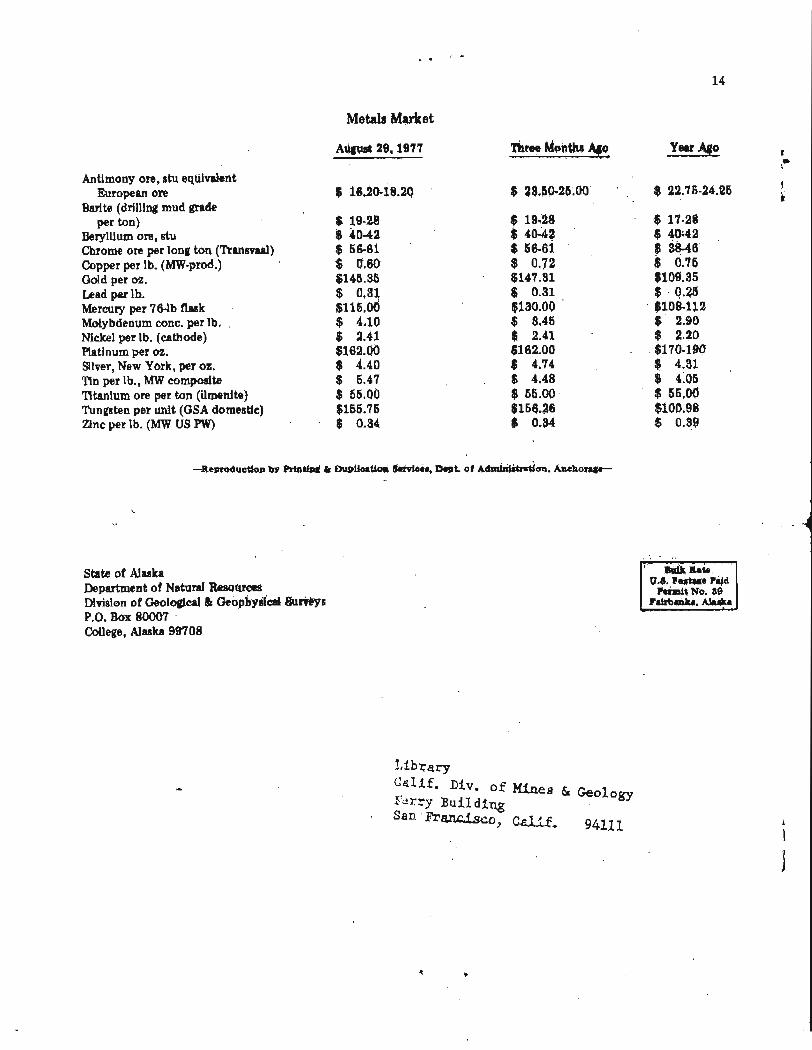
Metals Market
A w t 29,1977 -Ti: Ago
Antimony ore, stu equivalent European ore
Barite (drilling mud grade per ton)
Beryllium ore, stu Chrome ore per long ton (Transvaal) Copper per lb. (MW-prod.) Gold per oz. Lead p a lb. Mercury per 76-lb flask Molybdenum conc. per lb. Nickel per lb. (cathode) Platinum per 02.
Silver, New York, per 02. Tin per lb., MW composite Titanium ore per ton (ilmenite) Tungsten per unit (GSA domestic) Zinc per lb. (MW US PW)
State of Alaska Department of Natural Resouras Division of Geological & Geophysical Sut~@s P.O. Box 80007
&xmit No. 88


![Summer's Desire[1]](https://img.pdfslide.net/doc/110x75/577d34921a28ab3a6b8e58ef/summers-desire1.jpg)