Embed Size (px)
Citation preview
MINIMUM
REQUIREMENTS
FOR ALL
INSTRUMENTS OF
CONVEYANCE
IN
FAIRFIELD COUNTY
Jeremiah D. Upp P.E., P.S.
3026 West Fair Avenue, Lancaster, Ohio 43130-8993
2
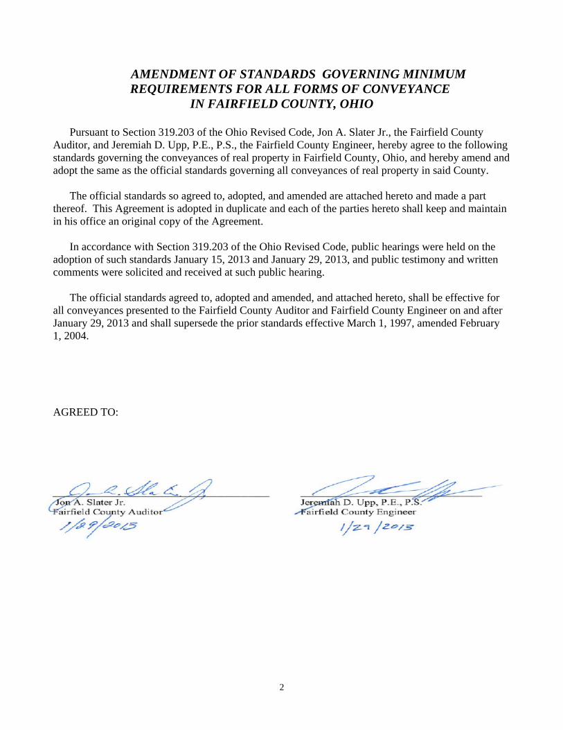
AMENDMENT OF STANDARDS GOVERNING MINIMUM REQUIREMENTS FOR ALL FORMS OF CONVEYANCE
IN FAIRFIELD COUNTY, OHIO
Pursuant to Section 319.203 of the Ohio Revised Code, Jon A. Slater Jr., the Fairfield County Auditor, and Jeremiah D. Upp, P.E., P.S., the Fairfield County Engineer, hereby agree to the following standards governing the conveyances of real property in Fairfield County, Ohio, and hereby amend and adopt the same as the official standards governing all conveyances of real property in said County.
The official standards so agreed to, adopted, and amended are attached hereto and made a part thereof. This Agreement is adopted in duplicate and each of the parties hereto shall keep and maintain in his office an original copy of the Agreement.
In accordance with Section 319.203 of the Ohio Revised Code, public hearings were held on the adoption of such standards January 15, 2013 and January 29, 2013, and public testimony and written comments were solicited and received at such public hearing.
The official standards agreed to, adopted and amended, and attached hereto, shall be effective for all conveyances presented to the Fairfield County Auditor and Fairfield County Engineer on and after January 29, 2013 and shall supersede the prior standards effective March 1, 1997, amended February 1, 2004. AGREED TO:
3
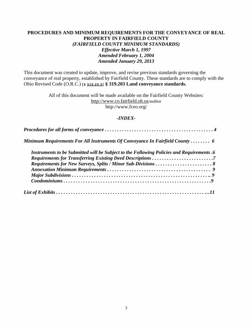
PROCEDURES AND MINIMUM REQUIREMENTS FOR THE CONVEYANCE OF REAL PROPERTY IN FAIRFIELD COUNTY
(FAIRFIELD COUNTY MINIMUM STANDARDS) Effective March 1, 1997
Amended February 1, 2004 Amended January 29, 2013
This document was created to update, improve, and revise previous standards governing the conveyance of real property, established by Fairfield County. These standards are to comply with the Ohio Revised Code (O.R.C.) [§ 319.20.3] § 319.203 Land conveyance standards.
All of this document will be made available on the Fairfield County Websites: http://www.co.fairfield.oh.us/auditor
http://www.fceo.org/
-INDEX- Procedures for all forms of conveyance . . . . . . . . . . . . . . . . . . . . . . . . . . . . . . . . . . . . . . . . . . . . 4 Minimum Requirements For All Instruments Of Conveyance In Fairfield County . . . . . . . . 6
Instruments to be Submitted will be Subject to the Following Policies and Requirements .6 Requirements for Transferring Existing Deed Descriptions . . . . . . . . . . . . . . . . . . . . . . . . .7 Requirements for New Surveys, Splits / Minor Sub-Divisions . . . . . . . . . . . . . . . . . . . . . . . 8 Annexation Minimum Requirements . . . . . . . . . . . . . . . . . . . . . . . . . . . . . . . . . . . . . . . . . . 9 Major Subdivisions . . . . . . . . . . . . . . . . . . . . . . . . . . . . . . . . . . . . . . . . . . . . . . . . . . . . . . . .. 9
Condominiums . . . . . . . . . . . . . . . . . . . . . . . . . . . . . . . . . . . . . . . . . . . . . . . . . . . . . . . . . . . .9
List of Exhibits . . . . . . . . . . . . . . . . . . . . . . . . . . . . . . . . . . . . . . . . . . . . . . . . . . . . . . . . . . . . …11
4
I. PROCEDURES FOR ALL FORMS OF CONVEYANCE To assist the public, we have listed the necessary steps to complete all types of conveyances. This section will explain where you have to go, in what order, and what you will need at each step in the conveyance process. The following procedures and standards have been adopted effective:
A. Existing numbered lots in recorded and platted additions and sub-divisions without metes and bounds descriptions. 1. To the GIS/Map Room 2. To the Auditor’s Office (Real Estate). 3. To the Recorder’s Office.
B. Existing tracts of record with metes and bounds descriptions.
1. To the GIS/Map Room (see Page 7, Section B). 2. To the Auditor’s Office (Real Estate). 3. To the Recorder’s Office.
C. New Metes and bounds descriptions (Minor Subdivisions-Lot Splits) in incorporated areas.
1. Obtain approval from the governing authority of the incorporated area. 2. To the GIS/Map Room for review and all applicable forms. 3. To the County Engineer’s Office for review and approval. 4. To the GIS/Map Room for completion of forms and filing of survey. 5. To the Auditor’s Office (Real Estate). 6. To the Recorder’s Office.
D. New Metes and bounds descriptions (Minor Subdivisions-Lot Splits) in unincorporated areas.
1. Lot Splits with an area less than 5.01 acres. a) To the GIS/Map Room for review and all applicable forms. b) To the County Engineer’s Office for review and approval (interoffice mail). c) To the GIS/Map Room for completion of forms and filing of survey (interoffice mail). d) To the Health Department for approval. e) To the Regional Planning Commission (RPC). The deed, an approved legal description,
and a copy of the survey must accompany the forms from the GIS/Map Room for RPC to process.
f) To the Auditor’s Office (Real Estate). g) To the Recorder’s Office.
2. Lot Splits (Minor Subdivisions-Lot Splits) with an area of 5.01 acres or more.
a) To the GIS/Map Room for review and all applicable forms. b) To the County Engineer’s Office for review and approval (interoffice mail). c) To RPC. The deed, an approved legal description, and a copy of the survey must
accompany the forms from the GIS/Map Room for RPC to process. d) To the Auditor’s Office (Real Estate). e) To the Recorder’s Office.
5
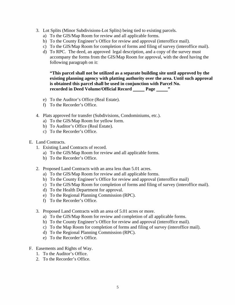
3. Lot Splits (Minor Subdivisions-Lot Splits) being tied to existing parcels. a) To the GIS/Map Room for review and all applicable forms. b) To the County Engineer’s Office for review and approval (interoffice mail). c) To the GIS/Map Room for completion of forms and filing of survey (interoffice mail). d) To RPC. The deed, an approved legal description, and a copy of the survey must
accompany the forms from the GIS/Map Room for approval, with the deed having the following paragraph on it:
“This parcel shall not be utilized as a separate building site until approved by the existing planning agency with platting authority over the area. Until such approval is obtained this parcel shall be used in conjunction with Parcel No. recorded in Deed Volume/Official Record Page ”
e) To the Auditor’s Office (Real Estate). f) To the Recorder’s Office.
4. Plats approved for transfer (Subdivisions, Condominiums, etc.).
a) To the GIS/Map Room for yellow form. b) To Auditor’s Office (Real Estate). c) To the Recorder’s Office.
E. Land Contracts.
1. Existing Land Contracts of record. a) To the GIS/Map Room for review and all applicable forms. b) To the Recorder’s Office.
2. Proposed Land Contracts with an area less than 5.01 acres.
a) To the GIS/Map Room for review and all applicable forms. b) To the County Engineer’s Office for review and approval (interoffice mail) c) To the GIS/Map Room for completion of forms and filing of survey (interoffice mail). d) To the Health Department for approval. e) To the Regional Planning Commission (RPC). f) To the Recorder’s Office.
3. Proposed Land Contracts with an area of 5.01 acres or more.
a) To the GIS/Map Room for review and completion of all applicable forms. b) To the County Engineer’s Office for review and approval (interoffice mail). c) To the Map Room for completion of forms and filing of survey (interoffice mail). d) To the Regional Planning Commission (RPC). e) To the Recorder’s Office.
F. Easements and Rights of Way. 1. To the Auditor’s Office. 2. To the Recorder’s Office.
6
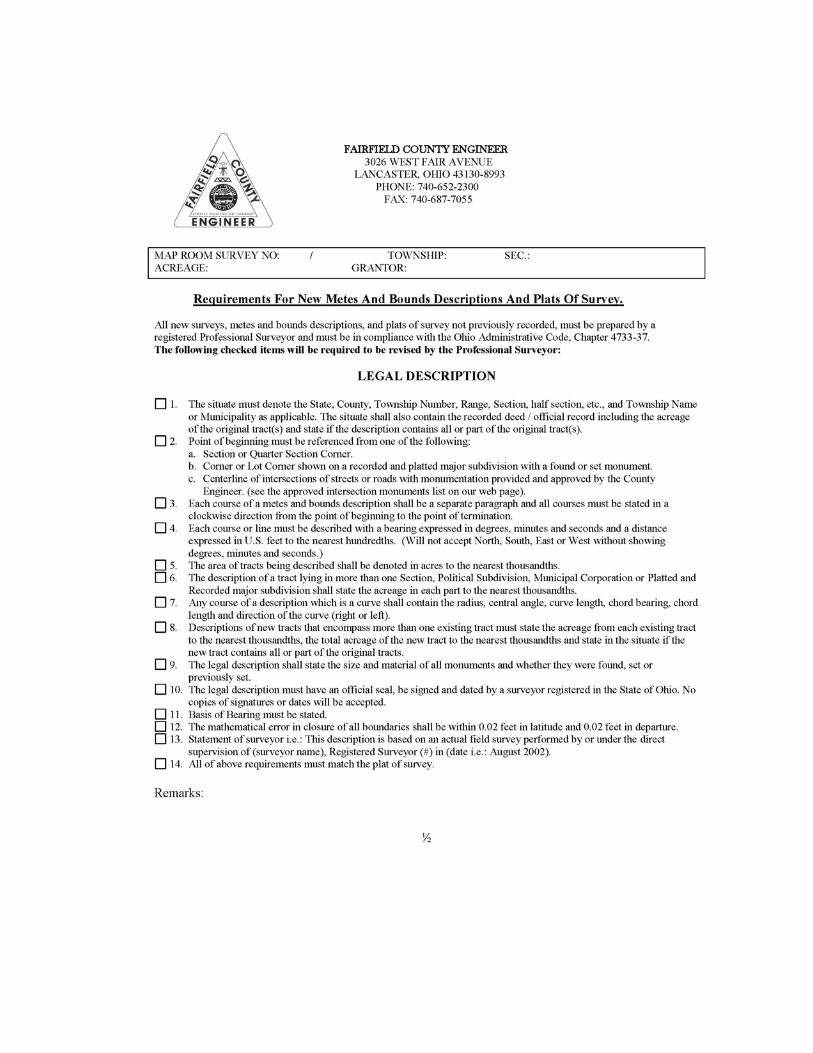
II. MINIMUM REQUIREMENTS FOR ALL INSTRUMENTS OF CONVEYANCE IN FAIRFIELD COUNTY
This document is the result of a law effective May 9, 1996. Ohio Revised Code Section 319.203 states that the County Auditor and the County Engineer, by written agreement, must adopt standards governing the conveyances of real property [§ 319.20.3] § 319.203 Land conveyance standards. The following Requirements are now adopted and established in cooperation between the Fairfield County Engineer and the Fairfield County Auditor. INSTRUMENTS TO BE SUBMITTED TO THE FAIRFIELD COUNTY’S AUDITOR’S OFFICE BEFORE CONVEYANCE AND/OR RECORDING ARE AS FOLLOWS: Existing descriptions of record, all street, alley, road, and subdivision vacations, new surveys, subdivisions, condominiums, and road establishments, annexation descriptions and land contracts.
A. INSTRUMENTS TO BE SUBMITTED WILL BE SUBJECT TO THE FOLLOWING POLICIES AND REQUIREMENTS: 1. It is understood that all situations not addressed by these requirements will be
handled as special cases by the Fairfield County GIS/Map Room. 2. Time requirements for review by the GIS/Map Room; All descriptions will be checked as
promptly as possible. 3. Instruments conveying a new survey description cannot be processed until reviewed and
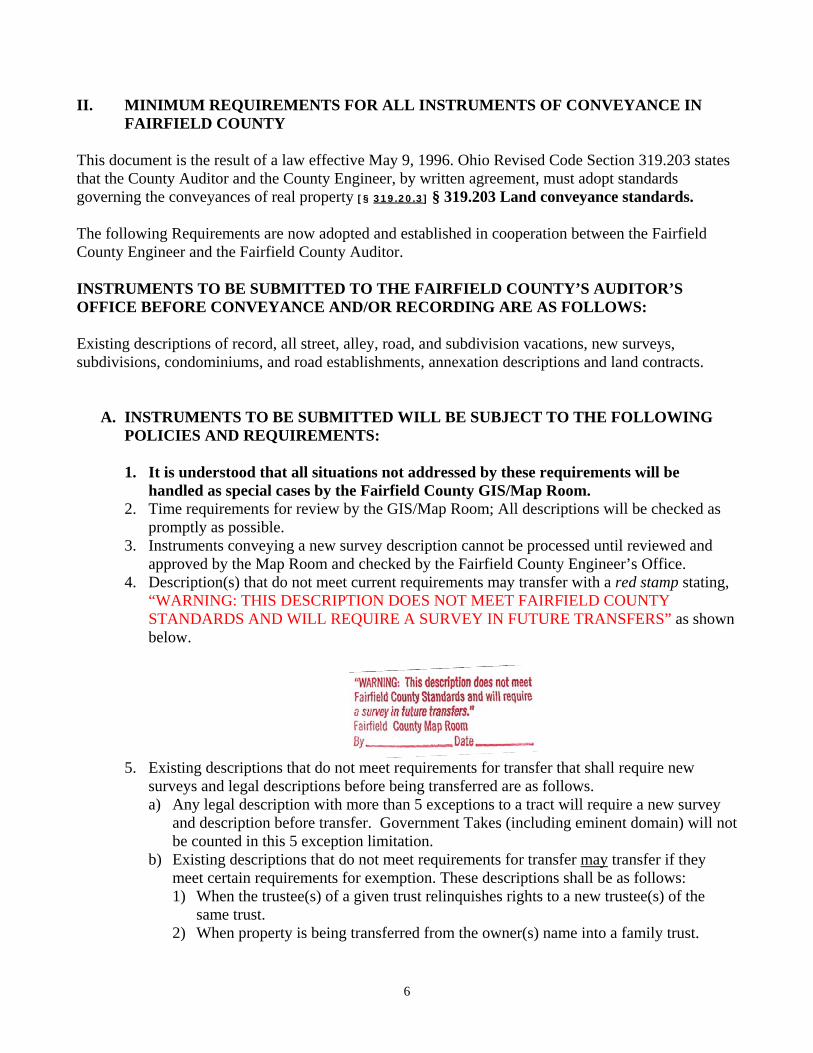
approved by the Map Room and checked by the Fairfield County Engineer’s Office. 4. Description(s) that do not meet current requirements may transfer with a red stamp stating,
“WARNING: THIS DESCRIPTION DOES NOT MEET FAIRFIELD COUNTY STANDARDS AND WILL REQUIRE A SURVEY IN FUTURE TRANSFERS” as shown below.
5. Existing descriptions that do not meet requirements for transfer that shall require new
surveys and legal descriptions before being transferred are as follows. a) Any legal description with more than 5 exceptions to a tract will require a new survey
and description before transfer. Government Takes (including eminent domain) will not be counted in this 5 exception limitation.
b) Existing descriptions that do not meet requirements for transfer may transfer if they meet certain requirements for exemption. These descriptions shall be as follows: 1) When the trustee(s) of a given trust relinquishes rights to a new trustee(s) of the
same trust. 2) When property is being transferred from the owner(s) name into a family trust.
7
3) When property is being transferred from a family trust into a member’s name of that trust.
4) When a person(s) inherits property by survivorship or per court order. 5) When property is being transferred from the owner(s) to an immediate family
member (parent to child, grandparent to grandchild, child to parent, grandchild to grandparent, sibling to sibling).
6) When the name of a trust is being changed but the trustee(s) remain the same. 6. All new descriptions and surveys submitted to the GIS/Map Room shall be originals with
the original signature, date, and stamp. 7. For existing descriptions being transferred, original documents are preferred; however,
copies of existing descriptions will be accepted if they are “clean copies”. No copies showing previous stamps, signatures, dates, or are in poor condition will be accepted. Faxed copies are unacceptable.
8. All corrective deeds must state exactly what is being corrected. 9. Descriptions/ plats submitted shall conform to the requirements as set forth in the
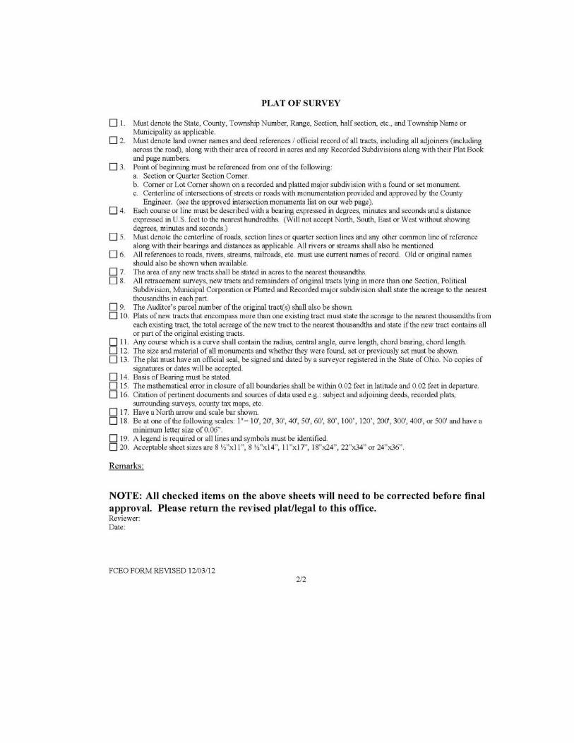
Requirements and Provisions of Chapter 711 in the O.R.C. and Sections 315.251 and 319.203. New surveys shall also conform to the Minimum Standards for boundary surveying in the State of Ohio, Administrative Code Chapter 4733-37 and the Requirements for New Metes and Bounds Descriptions and Plats of Survey set forth by the Fairfield County Engineer’s Office (see Exhibit B).
B. REQUIREMENTS FOR TRANSFERRING EXISTING DEED DESCRIPTIONS
1. All existing lots and out-lots, platted and un-platted. a) Lots in recorded subdivisions and additions which are shown on plats in the office of
the County Recorder shall be described by lot number, officially recorded name of addition or subdivision and with reference to a plat book/cabinet and page/slot number or envelope number.
b) Lots and out-lots in unrecorded subdivisions and additions shall be described by metes and bounds and adequately tied by metes and bounds (as noted in these standards). Such lots referred to by number will not be accepted for transfer.
c) When a split is involved see Requirements for New Metes and Bounds Descriptions and Plats of Survey (see Exhibit B).
2. All existing metes and bounds descriptions.
a) Legal descriptions referring to acreage in unplatted areas shall be by metes and bounds and adequately tied in by metes and bounds and shall reference to a point identifiable on a map of the area as follows:
b) Descriptions must use corners of sections or quarter sections, corners of section fractions, nearby recorded subdivision corner or corner of a specified lot in a recorded subdivision, or road intersections with established monuments depicting the corner of an existing tract, as the “tie”.
c) All descriptions must reference Township Name(s), Township Number(s), Section Numbers(s), and Range Number(s).
8
d) Vague terms are not acceptable, nor are references to points of beginning such as “in a northerly direction”, “with the meandering of a stream”, etc. Deeds containing these terms and others, if transferred in the past, may be transferred as outlined in Section II.A.1.
e) The description of a tract lying in more than one section, a tract of land lying in part within and in part outside a municipal corporation, or in two or more taxing districts, and a tract that includes portions of a recorded subdivision shall state the acreage lying in each part.
f) The description of a tract containing an exception(s) shall be fully described by lot number or metes and bounds and referenced by a prior recorded description that meets the current transfer requirements. The acreage of the exception shall be stated. No more than five (5) exceptions per tract will be permitted. Exceptions are to be added at the conclusion of the parent tract.
g) Multiple tracts being conveyed on one deed shall state the prior deed reference and if applicable the parcel number at the conclusion of each tract.
h) New Surveys are required for all splits and/or re-surveys as outlined in “Requirements for New Surveys, Splits/Minor Subdivisions.” - Section C (Also see Exhibit B)
i) Description(s) that differ in context from the prior recorded description, will not be accepted for transfer.
j) Description(s) with exceptions to the parent tract are permitted but no more than five (5) exceptions per individual parcel. Any description with more than five (5) exceptions will require a new survey for transfer.
k) Correcting scrivener errors - changes from the previous description that correct scrivener errors, omissions or other obvious mistakes are permitted in order for the description to be acceptable for transfer.
l) Acreage within a vacated subdivision must have a new survey before transferring, unless it meets current transfer requirements.
m) Sections, quarter sections, and fractions of sections and quarter sections are acceptable. n) An affidavit involving real estate that is presented to the Auditor’s Office shall have a
copy of the property description attached. o) The Preamble of all descriptions shall state the following: State, County, Township,
Range number, Township number, Section or Lot number, Subdivision, Quarter Section and Corporation/Municipality or Village.
p) Instrument preparation, the name and address of the person or Government agency which prepared the instrument must appear at the conclusion of the instrument. The name must be legible.
q) Any description which has been incorporated into a municipality or other political subdivision, since the previous conveyance, by means of annexation or de-annexation must be changed to reflect its new corporate location. Official road name changes should also be noted. (Prior road names, when known, should be so indicated.)
C. REQUIREMENTS FOR NEW SURVEYS, SPLITS/ MINOR SUBDIVISIONS
1. The survey and plat shall satisfy the requirements as set forth in The Minimum Standards for Boundary Surveying in the State of Ohio, Administrative Code chapter 4733-37 and promulgated by The Board of Registration for Professional Engineers and Surveyors of the State of Ohio pursuant to chapter 4733.
9
2. Must meet Requirements for New Metes and Bounds Descriptions and Plats of Survey set forth by the Fairfield County Engineers Office (see Exhibit B).
3. It is recommended that prior to completion of any survey, all applicable review agencies (see page 4 of these standards, “Procedures for All Forms of Conveyance”) should be consulted to verify all requirements of the survey. Additional requirements are as follows: a) Boundary surveys are required under the following circumstances:
1) When the legal description of the land to be conveyed is different from the legal description in the most recent conveyance.
2) When existing legal description of a parcel being conveyed has more than 5 exceptions.
3) When the current description is stamped with a red stamp (see section II paragraph A number 4)
D. ANNEXATION MINIMUM REQUIREMENTS
The description of the territory proposed for annexation and the plat furnished must comply with the requirements specified in the Ohio Revised Code. In addition, the following requirements for proposed annexations of territory within Fairfield County shall apply:
1. The territory proposed for annexation will have one metes and bounds description for the
entire area proposed for annexation. 2. When the territory proposed for annexation falls within more than one Township, the
description should summarize the total acreage lying within each involved Township in addition to stating the total acreage proposed for annexation.
3. Annexation plats should be provided in permanent ink on a reproducible tracing cloth, drafting film or other material subject to approval of the County Engineer.
4. Annexation plats must be submitted with a graphical scale clearly shown with the original drawing no smaller than 11 inches by 17 inches and no larger than 18 inches by 24 inches. Reduced size copies may be submitted for review purposes as long as all lettering and detailing is clearly legible.
5. All roadway names should be clearly indicated with existing right-of -way widths labeled. 6. All established monuments that exist should clearly indicate what type of monument.
Wherever roadway rights-of-way are met or crossed by a proposed annexation boundary that is proposed to be the outer boundary for the annexation the following additional requirements apply: a) An existing iron pin, concrete monument, or railroad spike (on centerline) must clearly
be labeled to show the change in road maintenance responsibility in the field. b) When no established monuments exists, iron pins as described in ORC 4733-37-03 shall
be added at the right-of-way limits in order to clearly indicate these points in the field. These shall be added within 30 days of annexation approval.
c) Any other established monuments along a proposed annexation will be subject to approval of the Fairfield County Engineer.
10
E. MAJOR SUBDIVISIONS
1. See the governing planning authority over the area for major subdivision regulations. 2. A legal description is required and must be included with the plat in order to be approved
and accepted. 3. To be recorded plat must be on 18 x 24 inch Mylar. 4. Signatures are required to be legible and in permanent ink. All signatures shall have the
name and title in print beneath.
F. CONDOMINIUMS
1. See the governing authority or planning authority over the area. 2. A legal description is required and must be included with the plat in order to be approved
and accepted. 3. To be recorded plat must be on 18 x 24 inch Mylar. 4. Signatures are required to be legible and in permanent ink. All signatures shall have the
name and title in print beneath.

11
LIST OF EXHIBITS
Exhibit A: Fairfield County GIS/Map Room Charges Exhibit B: Requirements for New Metes and Bounds Descriptions and Plats of Survey
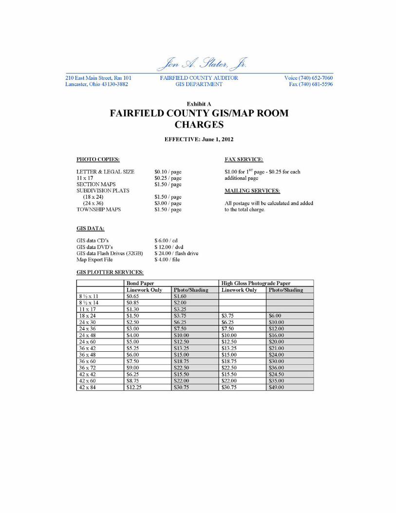

Exhibit B Requirements for New Metes and Bounds Descriptions and Plats of Survey
(Maintained by the Fairfield County Engineers Office as shown on the following two pages)