Embed Size (px)
Citation preview
Mining Assessment
at
Parrock Farm, Todmorden Road, Bacup, Lancashire, OL13 9UF
As part of the planning application for the development of 1.No wind turbine (Endurance E‐3120) at Parrock Farm the Coal Authority were commissioned to carry out a Ground Stability Report. This includes information on coal mining, brine subsidence and potential hazards relating to natural subsidence. See appendix for full report.
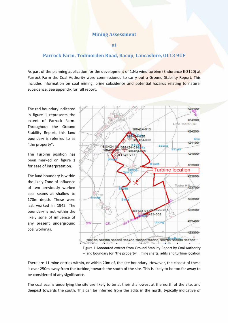
The red boundary indicated in figure 1 represents the extent of Parrock Farm. Throughout the Ground Stability Report, this land boundary is referred to as “the property”.
The Turbine position has been marked on figure 1 for ease of interpretation.
The land boundary is within the likely Zone of Influence of two previously worked coal seams at shallow to 170m depth. These were last worked in 1942. The boundary is not within the likely zone of influence of any present underground coal workings.
Figure 1 Annotated extract from Ground Stability Report by Coal Authority – land boundary (or “the property”), mine shafts, adits and turbine location
There are 11 mine entries within, or within 20m of, the site boundary. However, the closest of these is over 250m away from the turbine, towards the south of the site. This is likely to be too far away to be considered of any significance.
The coal seams underlying the site are likely to be at their shallowest at the north of the site, and deepest towards the south. This can be inferred from the adits in the north, typically indicative of

shallow seems. The almost vertical mine shafts toward the south of the site are typically indicative deeper seems. As the turbine lays towards the south, away from the shallow mine entries in the north, it is unlikely that it is close to shallow worked seams.
Prior to construction, an appropriate geotechnical survey will be carried out to assess the in‐situ ground conditions in more detail.
Appendix
Ground Stability Report
For
Parrock Farm
By
The Coal Authority
Issued by:The Coal Authority, Property Search Services, 200 Lichfield Lane, Berry Hill, Mansfield, Nottinghamshire, NG18 4RGWebsite: www.groundstability.com Phone: 0845 762 6848 DX 716176 MANSFIELD 5
DC21DC21 LIMITEDDENE HOUSE NORTH ROADHUDDERSFIELDWEST YORKSHIREHD8 0RW
Our reference: 51000115117001Your reference: Parrock Farm Ground
Date of your enquiry: 25 June 2012Date we received your enquiry: 25 June 2012
Date of issue: 26 June 2012
This report is for the property described in the address below and the attached plan. The report isissued subject to the terms and conditions attached, which you are strongly advised to read.
Non-Residential Ground Stability Report - On Coalfield
PARROCK FARM, TODMORDEN ROAD, BACUP, LANCASHIRE, OL13 9UFThis report is based on and limited to the records in the possession of the Coal Authority; the recordsand geological interpretation of The British Geological Survey (BGS) and the records of the CheshireBrine Subsidence Compensation Board, at the time the search is answered.
Coal mining See comments belowShrinkable clay See comments belowRunning sand See comments below
Compressible deposits See comments belowCollapsible deposits NoLandslide potential See comments below
Soluble rocks NoBrine Compensation District No
Information from the Coal AuthorityUnderground coal mining
PastThe property is in the likely zone of influence from workings in 2 seams of coal at shallow to 170mdepth, and last worked in 1942.PresentThe property is not in the likely zone of influence of any present underground coal workings.FutureThe property is not in an area for which the Coal Authority is determining whether to grant alicence to remove coal using underground methods.The property is not in an area for which a licence has been granted to remove or otherwise workcoal using underground methods.
All rights reserved. You must not reproduce, store or transmit any part of this document unless you have our written permission.© The Coal Authority © NERCNon-Residential Ground Stability Report - On Coalfield - 51000115117001 Page 1 of 9
-- -- --
The property is not in an area that is likely to be affected at the surface from any planned futureworkings.However, reserves of coal exist in the local area which could be worked at some time in thefuture.No notice of the risk of the land being affected by subsidence has been given under section 46 ofthe Coal Mining Subsidence Act 1991.
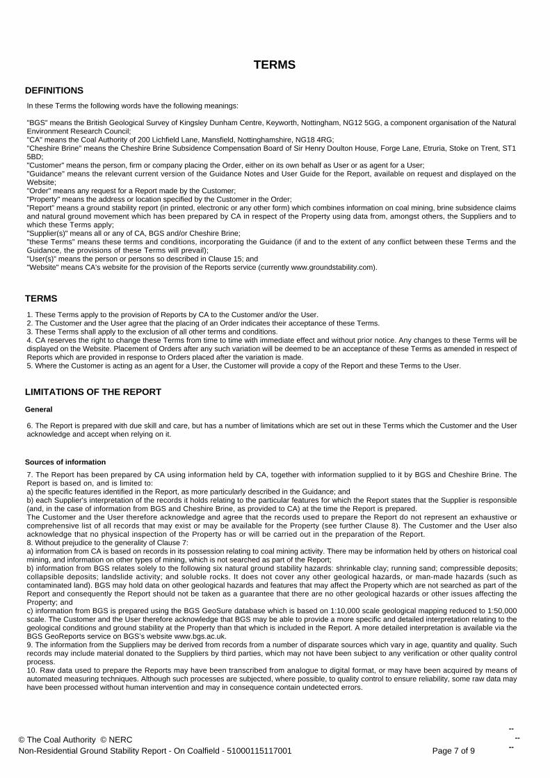
Mine entriesWithin, or within 20 metres of, the boundary of the property there are 11 mine entries, theapproximate positions of which are shown on the attached plan.
Our records disclose the following information:388424-017. No treatment details.388424-013. Our records show that this shaft has been filled at some time in the past toan unknown specification.388424-022. No treatment details.388423-001. No treatment details.388424-015. No treatment details.388423-008. No treatment details.388424-021. No treatment details.388424-025. No treatment details.388423-013. No treatment details.388423-014. No treatment details.388424-016. Our records show this adit was blocked up 3 metres inbye by subsidence in1962.Records may be incomplete. Consequently, there may exist in the local area mine entries ofwhich the Coal Authority has no knowledge.For an additional fee, the Coal Authority will provide a supplementary Mine Entry InterpretiveReport. The report will provide a separate assessment for the mine entry (entries) referred to inthis report. It will give details based on information in the Coal Authority's possession, togetherwith an opinion on the likelihood of mining subsidence damage arising from ground movement asa consequence of the existence of the mine entry/entries. It will also give details of the remediesavailable for subsidence damage where the mine entry was sunk in connection with coal mining.Please note that it may not be possible to produce a report if the main building to the propertycannot be identified from Coal Authority plans (ie. for development sites and new build).For further advice on how to order this additional information visit www.groundstability.com ortelephone 0845 7626 848.
Coal mining geologyThe Authority is not aware of any evidence of damage arising due to geological faults or otherlines of weakness that have been affected by coal mining.
Opencast coal miningPastThe property is not within the boundary of an opencast site from which coal has been removedby opencast methods.PresentThe property does not lie within 200 metres of the boundary of an opencast site from which coalis being removed by opencast methods.FutureThe property is not within 800 metres of the boundary of an opencast site for which the CoalAuthority is determining whether to grant a licence to remove coal by opencast methods.
© The Coal Authority © NERCNon-Residential Ground Stability Report - On Coalfield - 51000115117001 Page 2 of 9
-- -- --
The property is not within 800 metres of the boundary of an opencast site for which a licence toremove coal by opencast methods has been granted.
Coal mining subsidenceThe Coal Authority has not received a damage notice or claim for the subject property, or anyproperty within 50 metres, since 31st October 1994.There is no current Stop Notice delaying the start of remedial works or repairs to the property.The Authority is not aware of any request having been made to carry out preventive works beforecoal is worked under section 33 of the Coal Mining Subsidence Act 1991.
Mine gasThere is no record of a mine gas emission requiring action by the Coal Authority within theboundary of the property.
Hazards related to coal miningThe property has not been subject to remedial works, by or on behalf of the Authority, under itsEmergency Surface Hazard Call Out procedures.
Withdrawal of supportThe property is not in an area for which a notice of entitlement to withdraw support has beenpublished.The property is not in an area for which a notice has been given under section 41 of the CoalIndustry Act 1994, revoking the entitlement to withdraw support.
Working facilities ordersThe property is not in an area for which an Order has been made under the provisions of theMines (Working Facilities and Support) Acts 1923 and 1966 or any statutory modification oramendment thereof.
Payments to owners of former copyhold landThe property is not in an area for which a relevant notice has been published under the CoalIndustry Act 1975/Coal Industry Act 1994.
Comments on Coal Authority informationThe attached plan shows the approximate location of the disused mine entry/entries referred to inthis report. For reasons of clarity, mine entry symbols may not be drawn to the same scale as theplan.Property owners have the benefit of statutory protection (under the Coal Mining Subsidence act1991*). This contains provision for the making good, to the reasonable satisfaction of the owner,of physical damage from disused coal mine workings including disused coal mine entries. Aleaflet setting out the rights and the obligations of either the Coal Authority or other responsiblepersons under the 1991 Act can be obtained by telephoning 0845 762 6848 or online atwww.coal.decc.gov.uk/en/coal/cms/services/claims.If you wish to discuss the relevance of any of the information contained in this report you shouldseek the advice of a qualified mining engineer or surveyor. If you or your adviser wish to examinethe source plans from which the information has been taken these are normally available at ourMansfield office, free of charge, by prior appointment, telephone 01623 637235. Should you oryour adviser wish to carry out any physical investigations that may enter, disturb or interfere withany disused mine entry the prior permission of the owner must be sought. For coal mine entriesthe owner will normally be the Coal Authority.The Coal Authority, regardless of responsibility and in conjunction with other public bodies,provide an emergency call out facility in coalfield areas to assess the public safety implications ofmining features (including disused mine entries). Our emergency telephone number at all times is01623 646333.
© The Coal Authority © NERCNon-Residential Ground Stability Report - On Coalfield - 51000115117001 Page 3 of 9
-- -- --
*Note, this Act does not apply where coal was worked or gotten by virtue of the grant of a gale inthe Forest of Dean, or any other part of the Hundred of St. Briavels in the county of Gloucester.
In view of the mining circumstances a prudent developer would seek appropriate technical advicebefore any works are undertaken.Therefore if development proposals are being considered, technical advice relating to both theinvestigation of coal and former coal mines and their treatment should be obtained beforebeginning work on site. All proposals should apply good engineering practice developed formining areas. No development should be undertaken that intersects, disturbs or interferes withany coal or mines of coal without the permission of the Coal Authority. Developers should beaware that the investigation of coal seams/former mines of coal may have the potential togenerate and/or displace underground gases and these risks both under and adjacent to thedevelopment should be fully considered in developing any proposals. The need for effectivemeasures to prevent gases entering into public properties either during investigation or afterdevelopment also needs to be assessed and properly addressed. This is necessary due to thepublic safety implications of any development in these circumstances.
Information from the British Geological Survey on potential for natural ground movementShrinkable clay
The property is in an area underlain by clay. Clay can swell or shrink if the moisture contentchanges.However, the clay deposits in this area are considered to be mainly of "low plasticity". This meansit is unlikely that they will cause ground movement.
Running sandThe property is in an area underlain by sand. Some sands, if voids are present, may flow if theycome into contact with water.However, the sand deposits in this area are unlikely to cause ground movement.
Deposits which could compressThe property is in an area underlain by natural compressible deposits. When this material isoverloaded, or dries out, it can become unstable causing ground movement.Because of these compressible deposits, ground movement could occur.
Deposits which could collapseThe property is not in an area underlain by deposits which could collapse and cause groundmovement.
Natural landslide activityThe property is in an area where the local geology and steepness of slope could combine tocreate the likelihood of landslide activity.Because of the nature of the geology in this area landslide activity could occur.
Soluble rocksThe property is not in an area underlain by soluble rocks.
Comments on the British Geolological Survey informationThese features should not necessarily give cause for concern.Whether or not a property is affected by ground movement can depend on a number of factorssuch as its age, type of construction, and on its surroundings and such matters as drainage andnearby trees.Since 1992 buildings should have been designed and constructed according to buildingsregulations to ensure natural ground movement will not cause damage to a building.However, you should consider the possible consequences before you:
- carry out any building or excavation work; - alter the ground surface or drainage of surface or ground water; or
© The Coal Authority © NERCNon-Residential Ground Stability Report - On Coalfield - 51000115117001 Page 4 of 9
-- -- --
- plant or remove large shrubs or treesGround movement can cause uneven damage or subsidence to a property.Developers should always carry out an appropriate risk assessment before starting any work on,or around, a property.If you own the property and it is damaged by ground movement: You should contact yourinsurance company and anyone else who has an interest in the property, for example, themortgage lender.If you are considering buying the property and BGS has identified that ground movement couldoccur you should tell your professional advisers.
Information from the Cheshire Brine Subsidence Compensation BoardThe property lies outside the Cheshire Brine Compensation District.
Additional RemarksThis report is prepared in accordance with the Law Society's Guidance Notes 2006, the UserGuide 2006 and the Coal Authority, British Geological Survey and the Cheshire Brine SubsidenceCompensation Board's Terms and Conditions 2006. These are available to view atwww.groundstability.com or by contacting the Coal Authority's customer service team on 0845762 6848 or by email to [email protected]. These terms and conditions applyregardless of the method used to order and receive reports.The Coal Authority and British Geological Survey own the copyright in this report. The informationwe have used to write this report is protected by our database right. All rights are reserved andunauthorised use is prohibited. If we provide a ground stability report for you, this does not meanthat the copyright and any other rights will pass to you. However, you can use the report for yourown purposes.
Issued by: The Coal Authority, 200 Lichfield Lane,Mansfield, Nottinghamshire, NG18 4RG
Tax Point Date: 25 June 2012
Property Search for: PARROCK FARM, TODMORDENROAD, BACUP, LANCASHIRE, OL139UF
Reference Number: 51000115117001
Date of Issue: 26 June 2012
Cost: £89.00
VAT @ 20%: £17.80
Total Received: £106.80
VAT Registration 598 5850 68
DC21DC21 LIMITEDDENE HOUSE NORTH ROADHUDDERSFIELDWEST YORKSHIREHD8 0RW
Issued to:
© The Coal Authority © NERCNon-Residential Ground Stability Report - On Coalfield - 51000115117001 Page 5 of 9
-- -- --
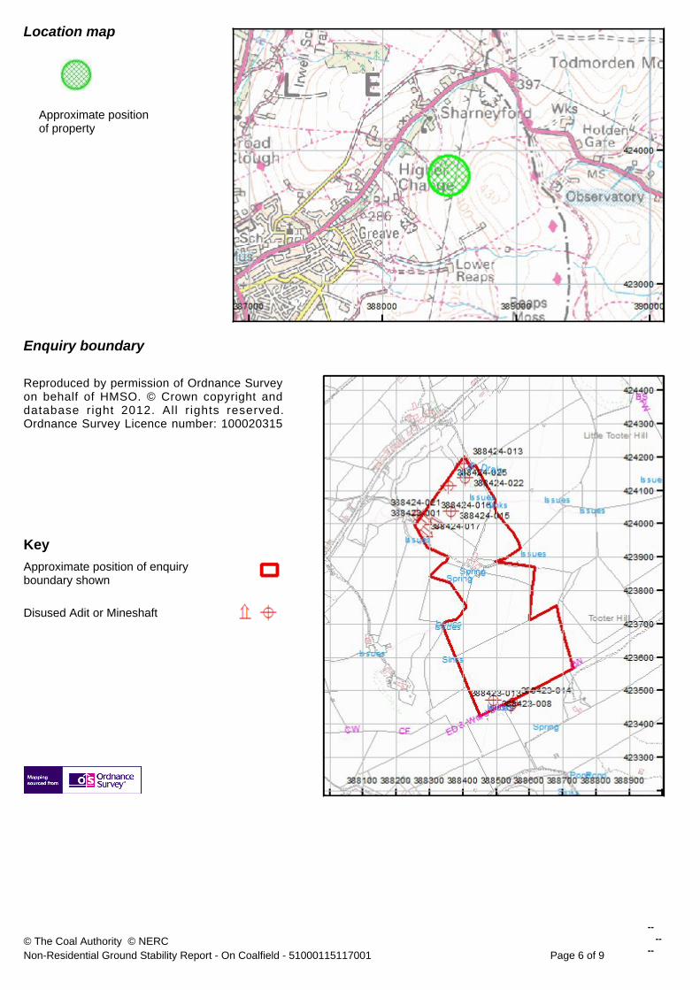
Approximate positionof property
Enquiry boundary
Reproduced by permission of Ordnance Surveyon behalf of HMSO. © Crown copyright anddatabase right 2012. All r ights reserved.Ordnance Survey Licence number: 100020315
KeyApproximate position of enquiryboundary shown
Disused Adit or Mineshaft
Location map
© The Coal Authority © NERCNon-Residential Ground Stability Report - On Coalfield - 51000115117001 Page 6 of 9
-- -- --
TERMS
DEFINITIONSIn these Terms the following words have the following meanings:
"BGS" means the British Geological Survey of Kingsley Dunham Centre, Keyworth, Nottingham, NG12 5GG, a component organisation of the NaturalEnvironment Research Council;"CA" means the Coal Authority of 200 Lichfield Lane, Mansfield, Nottinghamshire, NG18 4RG;"Cheshire Brine" means the Cheshire Brine Subsidence Compensation Board of Sir Henry Doulton House, Forge Lane, Etruria, Stoke on Trent, ST15BD;"Customer" means the person, firm or company placing the Order, either on its own behalf as User or as agent for a User;"Guidance" means the relevant current version of the Guidance Notes and User Guide for the Report, available on request and displayed on theWebsite;"Order" means any request for a Report made by the Customer;"Property" means the address or location specified by the Customer in the Order;"Report" means a ground stability report (in printed, electronic or any other form) which combines information on coal mining, brine subsidence claimsand natural ground movement which has been prepared by CA in respect of the Property using data from, amongst others, the Suppliers and towhich these Terms apply;"Supplier(s)" means all or any of CA, BGS and/or Cheshire Brine;"these Terms" means these terms and conditions, incorporating the Guidance (if and to the extent of any conflict between these Terms and theGuidance, the provisions of these Terms will prevail);"User(s)" means the person or persons so described in Clause 15; and"Website" means CA's website for the provision of the Reports service (currently www.groundstability.com).
TERMS
1. These Terms apply to the provision of Reports by CA to the Customer and/or the User.2. The Customer and the User agree that the placing of an Order indicates their acceptance of these Terms.3. These Terms shall apply to the exclusion of all other terms and conditions.4. CA reserves the right to change these Terms from time to time with immediate effect and without prior notice. Any changes to these Terms will bedisplayed on the Website. Placement of Orders after any such variation will be deemed to be an acceptance of these Terms as amended in respect ofReports which are provided in response to Orders placed after the variation is made.5. Where the Customer is acting as an agent for a User, the Customer will provide a copy of the Report and these Terms to the User.
LIMITATIONS OF THE REPORT
General
6. The Report is prepared with due skill and care, but has a number of limitations which are set out in these Terms which the Customer and the Useracknowledge and accept when relying on it.
Sources of information
7. The Report has been prepared by CA using information held by CA, together with information supplied to it by BGS and Cheshire Brine. TheReport is based on, and is limited to:a) the specific features identified in the Report, as more particularly described in the Guidance; andb) each Supplier's interpretation of the records it holds relating to the particular features for which the Report states that the Supplier is responsible(and, in the case of information from BGS and Cheshire Brine, as provided to CA) at the time the Report is prepared.The Customer and the User therefore acknowledge and agree that the records used to prepare the Report do not represent an exhaustive orcomprehensive list of all records that may exist or may be available for the Property (see further Clause 8). The Customer and the User alsoacknowledge that no physical inspection of the Property has or will be carried out in the preparation of the Report.8. Without prejudice to the generality of Clause 7:a) information from CA is based on records in its possession relating to coal mining activity. There may be information held by others on historical coalmining, and information on other types of mining, which is not searched as part of the Report;b) information from BGS relates solely to the following six natural ground stability hazards: shrinkable clay; running sand; compressible deposits;collapsible deposits; landslide activity; and soluble rocks. It does not cover any other geological hazards, or man-made hazards (such ascontaminated land). BGS may hold data on other geological hazards and features that may affect the Property which are not searched as part of theReport and consequently the Report should not be taken as a guarantee that there are no other geological hazards or other issues affecting theProperty; andc) information from BGS is prepared using the BGS GeoSure database which is based on 1:10,000 scale geological mapping reduced to 1:50,000scale. The Customer and the User therefore acknowledge that BGS may be able to provide a more specific and detailed interpretation relating to thegeological conditions and ground stability at the Property than that which is included in the Report. A more detailed interpretation is available via theBGS GeoReports service on BGS’s website www.bgs.ac.uk.9. The information from the Suppliers may be derived from records from a number of disparate sources which vary in age, quantity and quality. Suchrecords may include material donated to the Suppliers by third parties, which may not have been subject to any verification or other quality controlprocess.10. Raw data used to prepare the Reports may have been transcribed from analogue to digital format, or may have been acquired by means ofautomated measuring techniques. Although such processes are subjected, where possible, to quality control to ensure reliability, some raw data mayhave been processed without human intervention and may in consequence contain undetected errors.
© The Coal Authority © NERCNon-Residential Ground Stability Report - On Coalfield - 51000115117001 Page 7 of 9
-- -- --
11. The records available to the Suppliers are constantly being updated. The Suppliers cannot be responsible to the Customer or Users for anychanges in the information on which the Report is based which occur after the date on which the Report is prepared. Where this Report is for aresidential property, insurance is included to cover loss in property value caused and arising from these circumstances. The Report includes a policyand key facts summary which outlines the significant features, benefits and limitations of the cover provided. The full terms, conditions and exclusionsare shown in the policy document.
Maps
12. The Customer and the User must take all reasonable steps to check that the details in the Order are correct and that the Report provided by CAhas been prepared for the correct location and property type, and that the boundaries of the Property as shown in the Report’s plan correspond withthose of the Property. Any discrepancies between the Order and the Report must be notified to the CA within 28 days after the issue date of theReport and CA will, in the case of error by CA, issue a revised Report free of charge; otherwise a new Report should be ordered with payment of theappropriate fee.13. The Property has been located using Ordnance Survey ("OS") mapping. The Suppliers do not warrant that the OS information is complete oraccurate and accept no liability for the plotted position of the Property as shown on OS maps. Further, the relative position between surface featuresand coal mining and other geological features may differ between OS maps and the Suppliers’ maps used to prepare the Report, depending uponwhen the Suppliers’ maps were prepared.14. The plan or plans accompanying the Report must not be enlarged otherwise the accuracy will be affected.
RELIANCE ON THE REPORT
Who may rely on the Report
15. Only the following persons ("Users") may rely on the Report:a) the owner of the Property at the time the Report is prepared;b) any purchaser of the whole of the Property from the owner described in a above; andc) any person who provides funding to the persons in a or b above which is secured on the whole of the Property.Such reliance will be subject to the provisions of Clauses 17 and 24 to 28 (inclusive).
Extent of Reliance
16. The Report has been prepared for use by the Users only and the Report should not be relied upon by any other third party.17. Customers or Users may not act in reliance upon the Report (either by purchasing the Property, providing funding secured on the Property orcarrying out any works on or affecting the Property) more than ninety (90) days after its date of issue.18. The Report gives an indication of whether ground movement could occur at the Property. This does not necessarily mean that the Property is orwill be affected by ground instability. Such an assessment can only be made by inspection of the Property by a qualified professional, such as asurveyor or engineer. The Report DOES NOT therefore:a) include any information or warranty relating to the actual state, or the structural or other condition, of the Property;b) determine the saleability or value, or the safety, of the Property;c) indicate the suitability of the Property for any particular purpose (including, without limitation, its suitability for development (within the meaning ofsection 55 of the Town and Country Planning Act 1990 as amended) or any building, excavation or landscaping work); ord) act as a substitute for any physical inspection, specialist interpretations and/or professional advice.19. No representations, warranties or terms (whether express or implied by statute, common law, custom, trade usage, course of dealing orotherwise) are given in relation to the Report unless they are expressly set out in these Terms, save to the extent that such terms cannot be excludedby law.
USE OF THE REPORT
20. The Customer and the User acknowledge that the Report is confidential and that it is intended for the purposes of the User only. Accordingly theCustomer and the User agree that they are permitted to use and copy the Report for these purposes only.21. The Customer and the User (or any person who is provided with a copy of the Report) will not:a) remove, obliterate or alter any trade mark or any copyright or other proprietary notice which is contained in the Report;b) reformat or otherwise change, add to or enhance the Report, or combine it with or incorporate it into any other information, data or materials; orc) create any product which is derived directly or indirectly from the data contained in the Report; ord) resell the Report (other than in the case of a bona fide legal adviser recharging the cost of the Report as a disbursement) unless this has beenspecifically authorised in writing by CA.22. The copyright and all other intellectual property rights in the Report will remain the property of the Suppliers or other third parties (as appropriate).Neither the Customer nor the User will acquire any rights in respect of the Report other than as expressly provided in these Terms.
EVENTS BEYOND THE SUPPLIERS' CONTROL
23. A Supplier will not be liable to the Customer or the User for any delay or failure in performance of its obligations which result from circumstancesbeyond its reasonable control (including, without limitation, fire, explosion, flood, tempest, unusually adverse weather conditions, war, hostilities, riot,acts of terrorism, failure or shortage of power supplies, telecommunications or processing failure or computer malfunction) or the acts or omissions ofany person for which a Supplier is not legally responsible.
LIABILITY
24. The Report has been prepared for the Property on the basis of information on the Property’s location and type provided by the Customer and/orthe User, and consequently the Suppliers exclude all liability which may arise from any errors or omissions in the information so provided or from anyfailure to check for discrepancies pursuant to Clause 12.25. The Report has been prepared specifically for the Property, and on the basis of the property type specified in the Order. Under no circumstanceswill the Suppliers be liable if a Report is relied on for any other property, or if a Report on a residential property is used for a non-residential orcommercial property or for the development of the Property, and vice versa.
© The Coal Authority © NERCNon-Residential Ground Stability Report - On Coalfield - 51000115117001 Page 8 of 9
-- -- --
26. Except in the circumstances described in Clause 28 the total liability of the Suppliers to the Customer and the User arising from an error in theReport caused by negligence, breach of contract or in any other way will be limited to:a) the reasonable costs of carrying out necessary remedial work on the Property reasonably promptly; orb) the difference between the true market value of the Property and the market value of the Property on the basis of the Report at the time of relianceon the Report in accordance with these Terms.27. Except in the circumstances described in Clause 28 or to the extent that a Supplier is found to be liable for the losses described in Clause 26 (a)or (b) arising from an error in the Report, the Supplier will not be liable to the Customer or the User for: loss of business, goodwill, profits or savings,loss of use or opportunity, lost or wasted staff time or for any indirect or consequential loss (whether arising from negligence, breach of contract or in
GENERAL
29. The headings in these Terms are for ease of reference only and do not affect their interpretation or construction.30. Use of the singular includes the plural and vice versa, and use of any gender includes the other genders.31. The benefit of these Terms cannot be assigned or transferred by the Customer or the User without the Suppliers’ prior written consent. TheSuppliers may assign any or all of their rights and obligations under these Terms without prior notice.32. These Terms (together with the Order and the Guidance) represent the entire agreement relating to the supply of the Report and th relationshipwhich that supply creates between the Suppliers and Customers and Users. No prior statement, representation or arrangement of any nature(whether written or oral) will add to, vary or waive terms of this agreement and the Customer and the User acknowledge that they have not relied onany statement or representation made by or on behalf of CA or any other Supplier in agreeing to enter into this agreement. Nothing in this Clause 32will operate to limit or exclude liability for fraud.33. The illegality or invalidity of any part of these Terms will not affect the legality or validity of the remainder of these Terms.34. Except to the extent that these Terms confer benefits on the Suppliers and the Users, no third party is entitled to the benefit of these Terms underthe Contracts (Rights of Third Parties) Act 1999.35. These Terms are governed by English law. The English courts (where the Property is situated in England or Wales) and the Scottish courts(where the Property is situated in Scotland) have exclusive jurisdiction to deal with any dispute which may arise out of or in connection with them.
THESE TERMS ARE AVAILABLE IN LARGER PRINT FOR THOSE WITH IMPAIRED VISION OR ATWWW.COAL.GOV.UK
© The Coal Authority © NERCNon-Residential Ground Stability Report - On Coalfield - 51000115117001 Page 9 of 9
-- -- --