Embed Size (px)
Citation preview
Mining survey using
LiDAR
Presented by:
(n)Code Solutions, A Division of GNFC LtdLiDAR Survey for DMG, Karnataka
LiDAR
Table of contents
Understanding of LiDAR Technology
Objectives of LiDAR and GIS based Mining
Introduction – Terrestrial and Airborne LiDAR
Mining Solutions using LiDAR
Presented by:
(n)Code Solutions, A Division of GNFC LtdLiDAR Survey for DMG, Karnataka
Deliverables
Approach and Methodology
Roles and Responsibilities
Benefits
Objectives of Objectives of LiDARLiDAR and GIS based Miningand GIS based Mining
� Central Repository of lease wise reserves details at DMG Office
� Transparency in Operations and Governance
� Exploration and Resource Evaluation
� Determination of ore body, pit and void volumes for mine planning
� Periodic determination of pit, bench, pre-strip and spoil surface volumes for auditing payments to earthworks contractors
Presented by:
(n)Code Solutions, A Division of GNFC LtdLiDAR Survey for DMG, Karnataka
for auditing payments to earthworks contractors
� Periodic determination of stockpile volumes for inventory and accounting purposes
� Environmental planning, monitoring and reporting for the mining operation and the neighboring region
Understanding of Understanding of LiDARLiDAR TechnologyTechnology
� Till date theodolites and total stations has been the first choice for the surveyors.
� A laser-scanning instrument works on the principle of LiDAR (Light Detection And Ranging).
� The scanner emits laser rays, which hits the object to be captured and comes back to the scanner.
� Depending upon the total traveling time the scanner calculates the point distance in X, Y & Z.
� Laser scanner enables the surveyor to collect the data at lightning fast speed with
Presented by:
(n)Code Solutions, A Division of GNFC LtdLiDAR Survey for DMG, Karnataka
� Laser scanner enables the surveyor to collect the data at lightning fast speed with accurate 3D survey data.
� Within a very short period of time the scanner collects billions of points (point-cloud), this point cloud data can be used to create 3D models for a wide variety of spatial and volumetric tasks.
� The Laser Scanner is setting the standard for 3D laser scanning in all fields especially mining for capturing and documenting existing conditions. The multisensor platform is ideal for high speed data acquisition, and the integration of Photogrammetric cameras provides accuracy and completeness of projects demanded by the customers.
� The terrestrial laser scanner system consists of a high performance long-range 3D laser scanner, associated operating and processing software, and a calibrated and definitely orientated high-resolution digital camera.
Open Pit and Tailings
� In the mining industry, it is imperative to have a fast and effective way to collect
high resolution survey data of engineering quality for open pit mining and tailings ponds.
� Ground-based scanning and conventional surveying methods take days or weeks
Presented by:
(n)Code Solutions, A Division of GNFC LtdLiDAR Survey for DMG, Karnataka
� Ground-based scanning and conventional surveying methods take days or weeks
which can interfere with production activities.
� The safety of personnel who collect the data is often a major issue in areas of surface mining activity where there are large heavy vehicles constantly on the move.
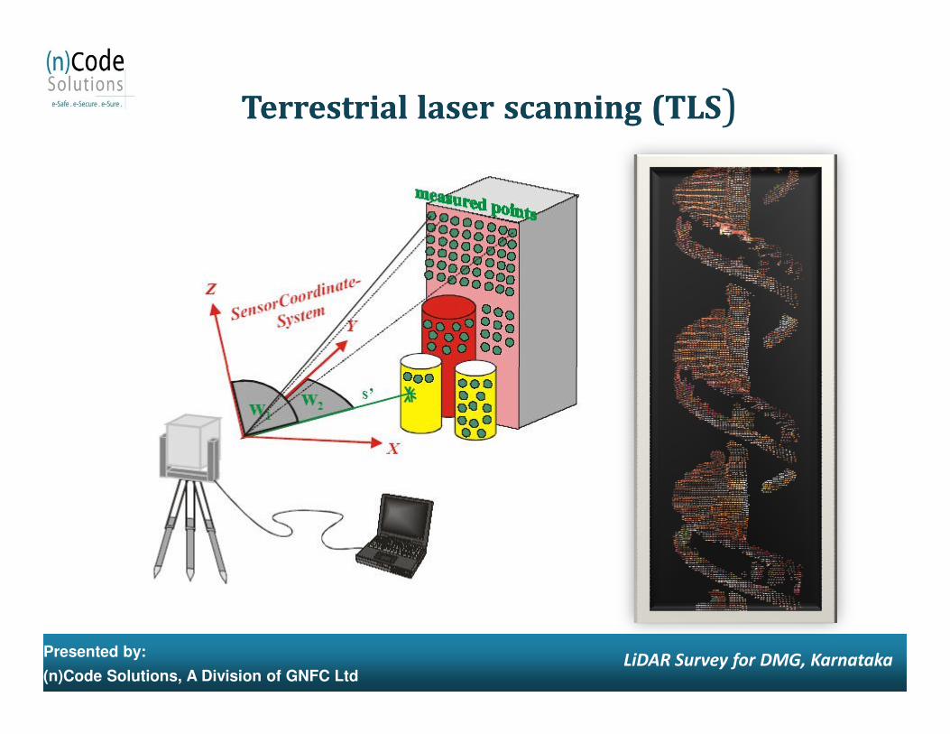
TerrestrialTerrestrial laserlaser scanningscanning (TLS(TLS)
Presented by:
(n)Code Solutions, A Division of GNFC LtdLiDAR Survey for DMG, Karnataka
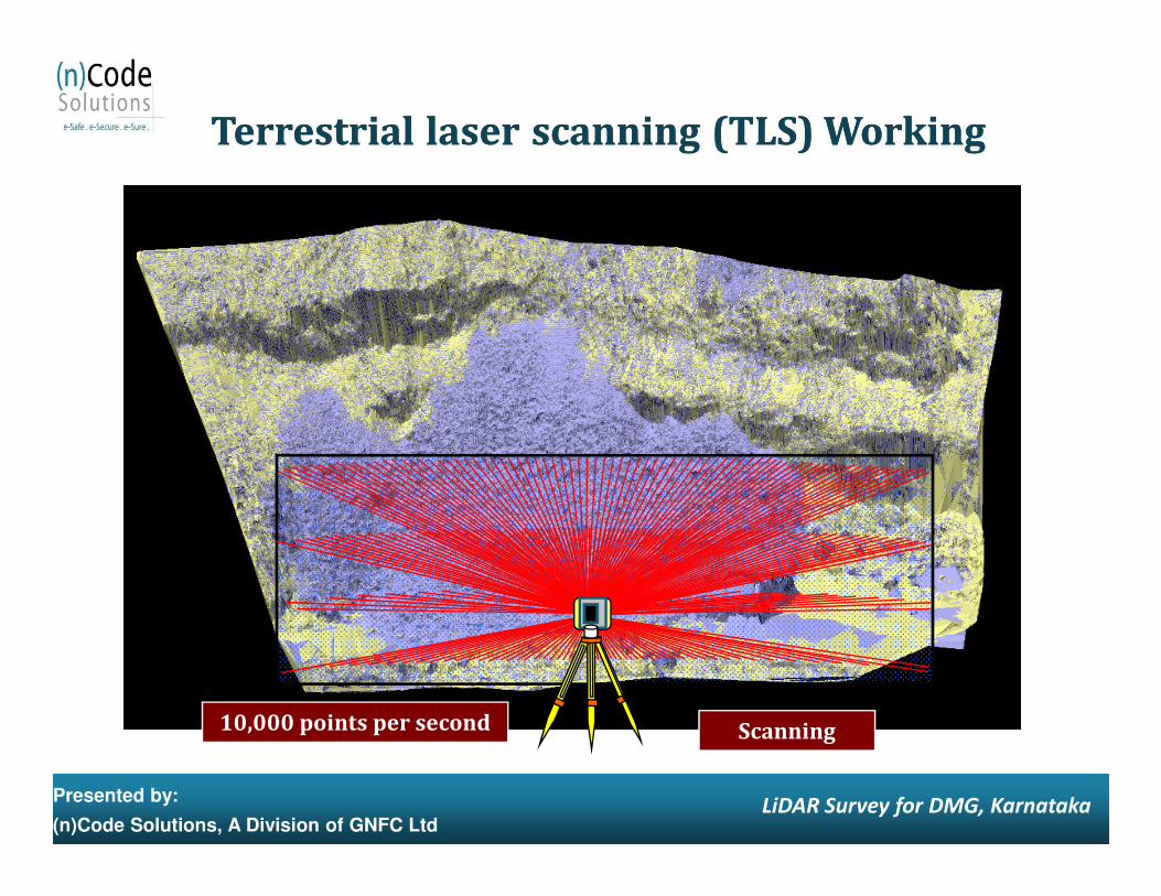
TerrestrialTerrestrial laserlaser scanningscanning (TLS) Working(TLS) Working
Presented by:
(n)Code Solutions, A Division of GNFC LtdLiDAR Survey for DMG, Karnataka
Scanning10,000 points per second
Why LiDAR Technology ?Why LiDAR Technology ?
� LiDAR scanning is far safer than conventional surveying methods and takes only a fraction of the time.
� The speed at which data is collected minimizes delays to the mining
schedules and processes. For example, operational mine faces can often be surveyed in the time during shift change, causing zero delays in production.
� The LiDAR solution is ideal for finding differences between two time
periods to accurately monitor the changes in the terrain.
Presented by:
(n)Code Solutions, A Division of GNFC LtdLiDAR Survey for DMG, Karnataka
periods to accurately monitor the changes in the terrain.
� Data from the LiDAR solution dovetails cleanly into existing data workflows to produce deliverables including engineering drawings, as-built, contours and volumes.
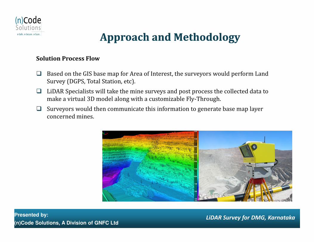
Solution Process Flow
� Based on the GIS base map for Area of Interest, the surveyors would perform Land Survey (DGPS, Total Station, etc).
� LiDAR Specialists will take the mine surveys and post process the collected data to make a virtual 3D model along with a customizable Fly-Through.
� Surveyors would then communicate this information to generate base map layer concerned mines.
Approach and MethodologyApproach and Methodology
Presented by:
(n)Code Solutions, A Division of GNFC LtdLiDAR Survey for DMG, Karnataka
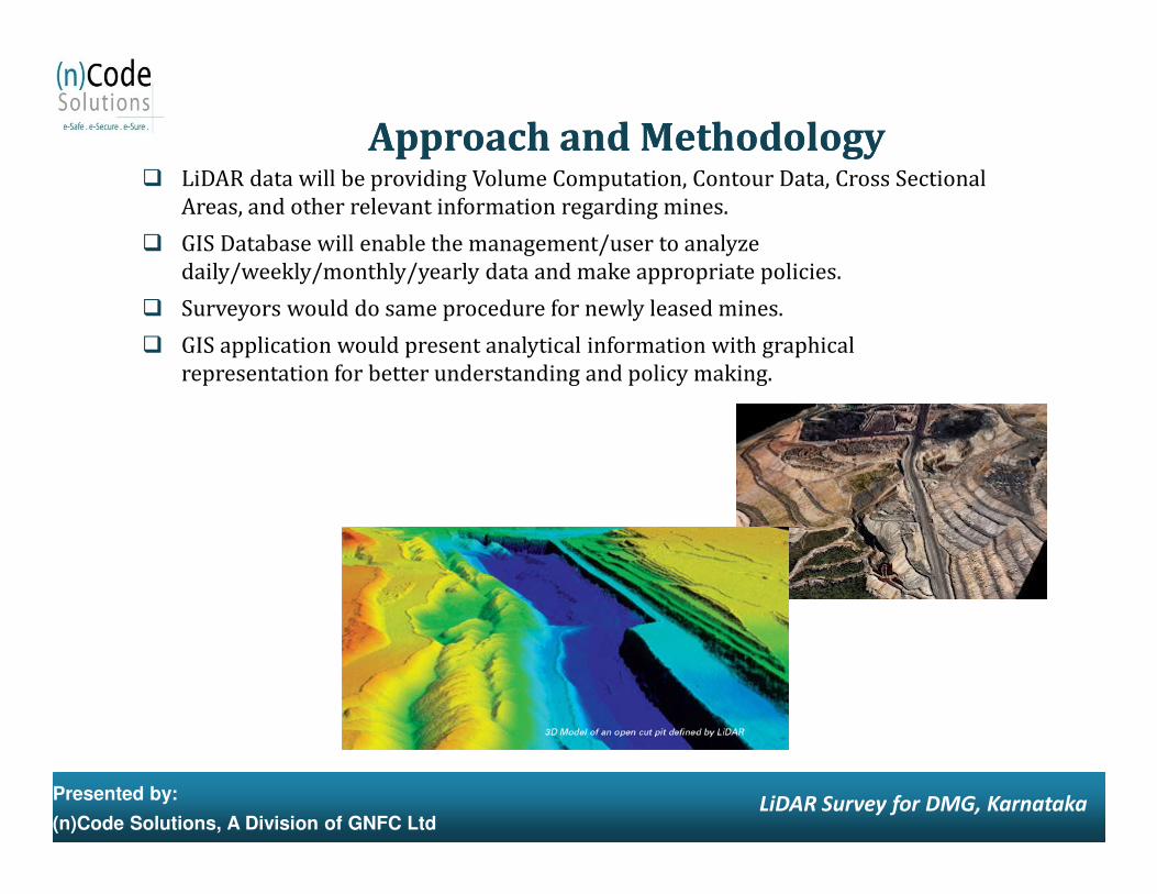
� LiDAR data will be providing Volume Computation, Contour Data, Cross Sectional Areas, and other relevant information regarding mines.
� GIS Database will enable the management/user to analyze daily/weekly/monthly/yearly data and make appropriate policies.
� Surveyors would do same procedure for newly leased mines.
� GIS application would present analytical information with graphical representation for better understanding and policy making.
Approach and MethodologyApproach and Methodology
Presented by:
(n)Code Solutions, A Division of GNFC LtdLiDAR Survey for DMG, Karnataka
Methodology (GIS Map Creation)Methodology (GIS Map Creation)
� Source data for land base mapping is High Resolution Satellite imagery and various ward and survey Topo maps.
� Before the capture process, image is registered to the DGPS points (10 cm accuracy) to achieve the desired positional accuracy.
� Field Survey Team captures features such as Building footprint, Road, Street centerline, Alley, Median, Cluster of Trees, Plot boundaries.
� Feature like Ward boundaries, Railway corridor, Utility features, Contours etc. are also captured.
Input Data
Presented by:
(n)Code Solutions, A Division of GNFC LtdLiDAR Survey for DMG, Karnataka
Input Data
� High Resolution Satellite Imagery
� Ward Maps
� Survey of India Topo maps
� DGPS survey points
� Railway corridor maps
� Utility Maps
Output Format
� ArcGIS GeoDatabase
Using Terrestrial Sensors: LiDARUsing Terrestrial Sensors: LiDAR
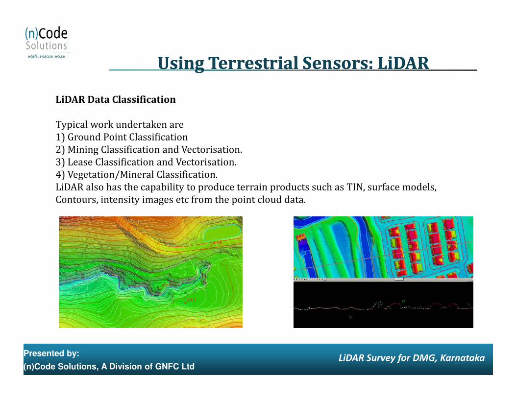
LiDAR Data Classification
Typical work undertaken are1) Ground Point Classification2) Mining Classification and Vectorisation.3) Lease Classification and Vectorisation.4) Vegetation/Mineral Classification.LiDAR also has the capability to produce terrain products such as TIN, surface models, Contours, intensity images etc from the point cloud data.
Presented by:
(n)Code Solutions, A Division of GNFC LtdLiDAR Survey for DMG, Karnataka
Contours, intensity images etc from the point cloud data.
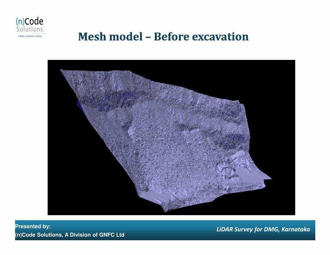
Mesh model Mesh model –– Before excavationBefore excavation
Presented by:
(n)Code Solutions, A Division of GNFC LtdLiDAR Survey for DMG, Karnataka
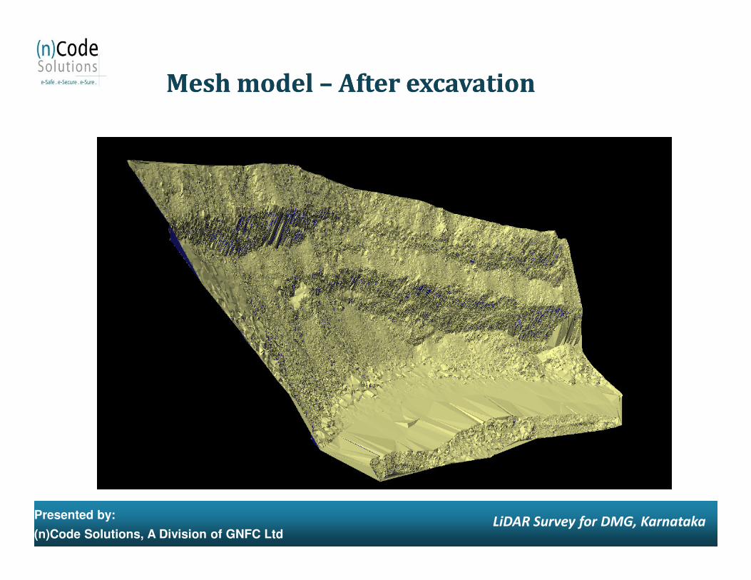
Mesh model Mesh model –– After excavationAfter excavation
Presented by:
(n)Code Solutions, A Division of GNFC LtdLiDAR Survey for DMG, Karnataka
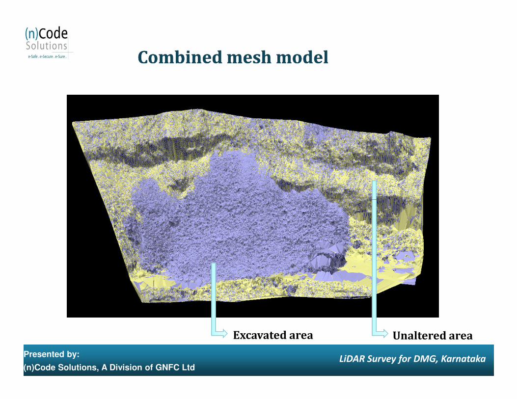
Combined mesh modelCombined mesh model
Presented by:
(n)Code Solutions, A Division of GNFC LtdLiDAR Survey for DMG, Karnataka
Excavated area Unaltered area
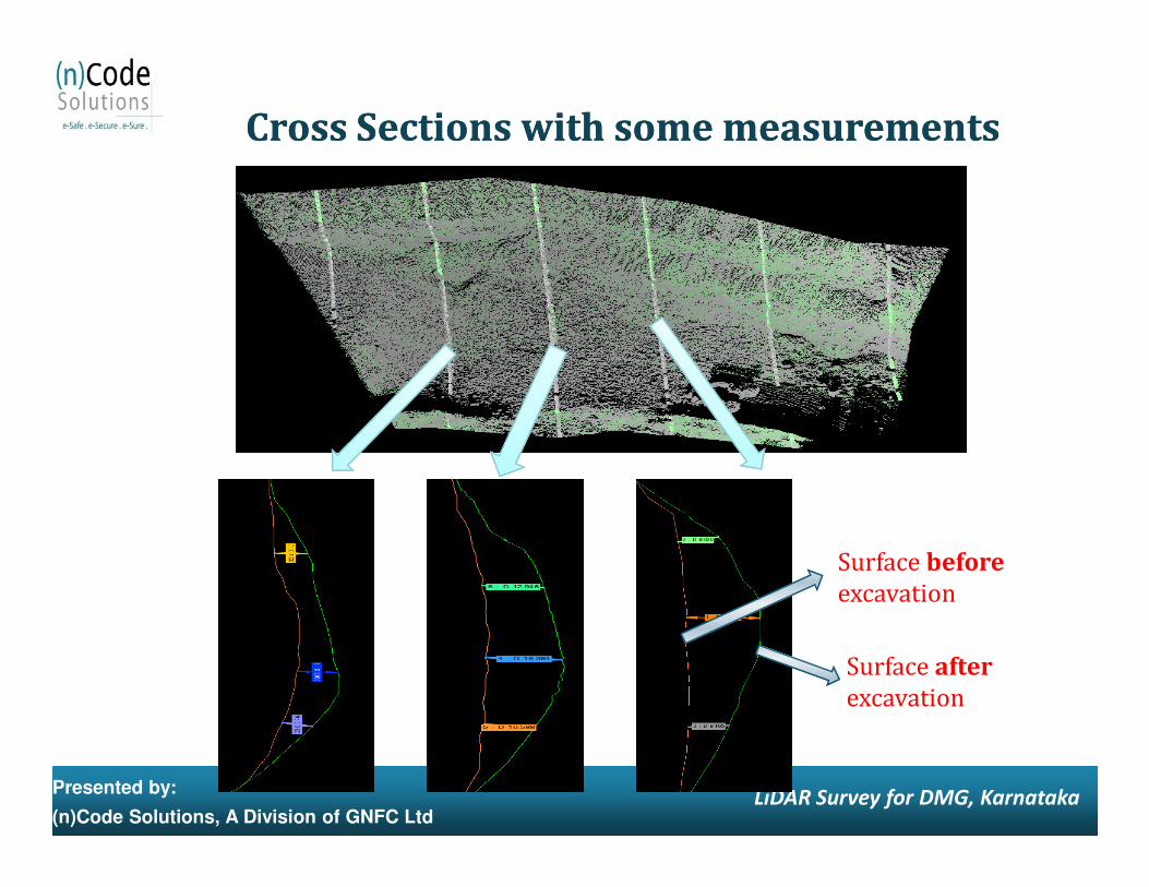
Cross Sections with some measurementsCross Sections with some measurements
Presented by:
(n)Code Solutions, A Division of GNFC LtdLiDAR Survey for DMG, Karnataka
Surface before
excavation
Surface after
excavation
Anticipated Benefits
� Swifter Delivery Time: Unlike aerial photogrammetry, LiDAR surveys do not require ground control targets, allowing mine surveyors to concentrate on other important operational activities - The project critical path to delivery of data can be much shorter and simpler, relying more on CPU computation time than on man hours LiDAR surveys are particularly well suited to time-critical applications, in terms of capture window and delivery time. For example: - Stockpile surveys that are required on the last day of the month, to coincide with the financial reporting period - Specific surveys where the capture window is either very limited or time critical such as pre or post blast, start or end of contract, ship or train loading, empty or new stockpile
BenefitsBenefits
Presented by:
(n)Code Solutions, A Division of GNFC LtdLiDAR Survey for DMG, Karnataka
or post blast, start or end of contract, ship or train loading, empty or new stockpile pads and blending yards
� Fast Capturing Speed: With capturing speed of ~10000pts/sec, it captures millions of points within a very short period of time whereas a Total Station captures one point/minute.
� Easy to Operate: A surveyor with total station knowledge and little computer knowledge will find it easy to operate the laser scanner without any difficulties.
� Inclination Sensor: With inclination sensor there is absolutely no need to level the instrument.
� Range: A laser scanner can scan up to 1500 meters (radius), with a field of view of 360°(H) x 80°(V), there by covering a large area in single scan.
� Onboard Digital Camera: The scanner has High Mega Pixel onboard digital camera, which allows to pick up true color of the scene there by creating a virtual reality of the mine. It also helps in demarcation of coal blocks and geological investigations.
Presented by:
(n)Code Solutions, A Division of GNFC LtdLiDAR Survey for DMG, Karnataka
the mine. It also helps in demarcation of coal blocks and geological investigations.
� Accuracy: The laser scanner can easily achieve an accuracy of 15-20 mm during topographic survey, thereby providing accurate topo data.
� Better visualization and data processing (as compared to Tabular Data) for Decision Making through Spatial GIS database.
� Proper Land use planning can be done.
� Same database can be used by various authorities.
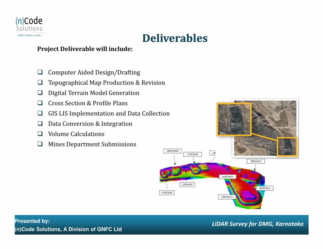
Project Deliverable will include:
� Computer Aided Design/Drafting
� Topographical Map Production & Revision
� Digital Terrain Model Generation
� Cross Section & Profile Plans
� GIS LIS Implementation and Data Collection
� Data Conversion & Integration
DeliverablesDeliverables
Presented by:
(n)Code Solutions, A Division of GNFC LtdLiDAR Survey for DMG, Karnataka
� Data Conversion & Integration
� Volume Calculations
� Mines Department Submissions

Roles and Responsibilities will include:
Roles and ResponsibilitiesRoles and Responsibilities
Sr. No Components n-Code DMG Lessee
1 Location Details √2 Location GIS MAP √3 Image Procurement √4 Validation of GIS MAP √5 Image Digitization √6 Ordering process √7 Overall Schedule for Survey √ √8 Site Readiness Checklist √ √9 Order for individual Lease √ √10 Intimation to lessee for Survey with pre-requisite √11 Server for Setup √12 Software Deploy √13 Points of Contact Details of lessee √ √
Presented by:
(n)Code Solutions, A Division of GNFC LtdLiDAR Survey for DMG, Karnataka
13 Points of Contact Details of lessee √ √14 Site Readiness Intimation to lessee √15 Confirmation of site readiness √16 Mobilizing the Team √17 Site Team for co-ordination √ √18 Local Conveyance √19 Pre - Survey for LiDAR √ √ √20 Feasibility Report √21 Approval of feasibility √22 Field Survey and Data Collection √23 Field Survey Verification √ √24 Data Correction and Conversion √25 Database Preparation √26 Base Map Preparation √27 LiDAR Report √28 Work Completion Certificate √ √29 Invoice √30 Payment √31 Change detection survey schedule finalization √ √ √
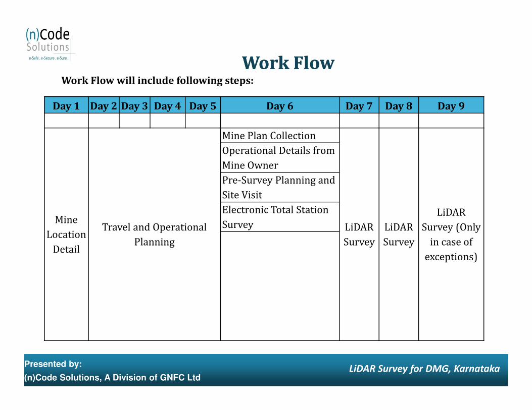
Work Flow will include following steps:
Work FlowWork Flow
Day 1 Day 2 Day 3 Day 4 Day 5 Day 6 Day 7 Day 8 Day 9
Mine Plan CollectionOperational Details from Mine OwnerPre-Survey Planning and Site VisitElectronic Total Station
Presented by:
(n)Code Solutions, A Division of GNFC LtdLiDAR Survey for DMG, Karnataka
Mine Location
Detail
Travel and Operational Planning
LiDAR Survey
LiDAR Survey
LiDAR Survey (Only
in case of exceptions)
Electronic Total Station Survey
Thank You …
Presented by:
(n)Code Solutions, A Division of GNFC LtdLiDAR Survey for DMG, Karnataka