Embed Size (px)
Citation preview
MINISTRY OF ENVIRONMENT, DIGEPESCA, HONDURAS
ACTIVITIES OF THE PROTECTIVE TURTLE ECOLOGY CENTER FOR TRAINING, OUTREACH, AND RESEARCH, INC. (ProTECTOR) IN HONDURAS 2011 and 2012 ANNUAL REPORT February 27, 2013
2
ACTIVITIES OF THE PROTECTIVE TURTLE
ECOLOGY CENTER FOR TRAINING, OUTREACH,
AND RESEARCH, INC (ProTECTOR) IN HONDURAS
ANNUAL REPORT OF THE
2011 and 2012 SEASONS
Principal Investigator: Stephen G. Dunbar1,2,3,4
Co-Principal Investigator: Lidia Salinas2,3
1President, Protective Turtle Ecology Center for Training, Outreach, and Research, Inc. (ProTECTOR),
2569 Topanga Way, Colton, CA 92324, USA 2 Turtle Awareness and Protection Studies (TAPS) Program, Oak Ridge, Roatán, Honduras
3Protective Turtle Ecology Center for Training, Outreach, and Research, Inc. (ProTECTOR), Tegucigalpa,
Honduras
4Department of Earth and Biological Sciences, Loma Linda University, Loma Linda, CA 92350, USA
PREFACE This report represents the ongoing work of the Protective Turtle Ecology Center for Training, Outreach, and Research,
Inc. (ProTECTOR) in Honduras. The report covers activities of ProTECTOR during the 2011 and 2012 calendar
years, and is provided in partial fulfillment of the research permit agreements provided to ProTECTOR by
DIGEPESCA.
ACKNOWLEDGEMENTS ProTECTOR recognizes that without the financial assistance of the Department of Earth and Biological Sciences
(Loma Linda University), these ongoing projects could not take place. The Global Health Institute (LLU and the
Students for International Mission Service (LLU) also supported various aspects of our community outreach. We are
grateful to Loma Linda University graduate students Noemi Duran, Noel Wingers, and Lindsey Eggers Damazo for
directing field studies, and to ProTECTOR Interns Amy Tan and Robyn Reeve, as well as SURP Student Ariana
Cunningham, and ProTECTOR Volunteers Ken Lindsay, Terri Eggers, and Dustin Baumbach for all their hard work
on field projects. Jason Damazo assisted with maps and beach plot figures. We also acknowledge students from the
National Autonomous University of Honduras (UNAH) that were involved in the collection of some data provided in
this report as part of their practical requirements for graduation. Some projects were facilitated, in large part, by Snr.
Henrique Vihil and the community of El Venado who have formed a partnership with ProTECTOR to increase
opportunities for continued investigations in the South Coast in the coming seasons. We are also indebted to the
community of Punta Ratón and the Municipality of Marcovia for their participation in these sea turtle conservation
efforts. We thank Noemi Duran for assistance in organizing and tabulating data collected from this and past years. The
Reef House Resort, Fantasy Island Resort, CocoView Resort, their respective Dive Masters, and guests of all three
resorts have been continuing partners in the conservation and research efforts on Roatan. We thank Angela Randazzo
for directing the field work at Cuero y Salado Wildlife Refuge, along with the communities of Salado Bar, Orotina, La
Rosita, and Boca Cerrada for their participation in the study there. We are grateful to Snr. Jose “Pepe” Herrero for his
continued interest and support of the work of ProTECTOR. In addition, the Foundation for Cuero y Salado (FUCSA),
especially Ana Paz and Ana Padilla, and the Bay Islands Conservation Association (BICA) in Utila, especially Pamela
Ortega, Alba Giesella “Chel” Morales Rivera, Gene Gerald Jackson, Patricia Steffan, and Jenny Luque, have all been
excellent allies in the efforts to further conservation in Honduras. These studies were conducted under approval from
the Loma Linda University Institutional Animal Care and Use Committee (IACUC) (Protocol # 89029), and the Loma
Linda University Institutional Review Board (IRB) (Protocol # 5120308 and # 5120097), and are in compliance with
United States and Honduran law.
February 27, 2013
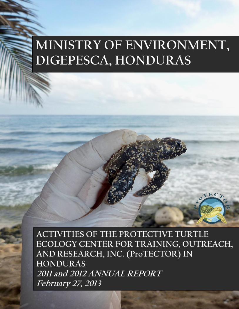
Cover image: This Hawksbill hatchling represents the potential for increasing the number of successful hatchlings and
recovery of hawksbill populations throughout Honduras. Photo: Terri Eggers.
3
TABLE OF CONTENTS
INTRODUCTION AND BACKGROUND .............................................................................. 4
ADDITIONAL METHODS....................................................................................................... 5 Bay Islands ............................................................................................................................... 5
Utila 2011 ............................................................................................................................. 5
Utila 2012 ............................................................................................................................. 5 Roatán 2012 ......................................................................................................................... 8 Guanaja 2011 ....................................................................................................................... 8 Guanaja 2012 ....................................................................................................................... 8
North Coast ............................................................................................................................... 9
Cuero y Salado Wildlife Refuge 2011 .................................................................................. 9 Cuero y Salado Wildlife Refuge, 2012 ............................................................................... 10
South Coast ............................................................................................................................. 11
Punta Ratón 2011 ............................................................................................................... 11 Punta Ratón 2012 ............................................................................................................... 11
El Venado 2011 .................................................................................................................. 12 El Venado 2012 .................................................................................................................. 12
East Pacific Hawksbills 2011 ............................................................................................. 13
OVERALL RESULTS ............................................................................................................. 14 Bay Islands 2011 .................................................................................................................... 14
Utila .................................................................................................................................... 14 Roatán ................................................................................................................................ 16
Guanaja .............................................................................................................................. 18
South Coast 2011 .................................................................................................................... 18
Punta Ratón ........................................................................................................................ 18 El Venado ........................................................................................................................... 22
East Pacific Hawksbills ...................................................................................................... 26
Bay Islands 2012 .................................................................................................................... 34
Utila .................................................................................................................................... 34
Roatán ................................................................................................................................ 42 Guanaja .............................................................................................................................. 42
North Coast 2012 .................................................................................................................... 43
Cuero y Salado Wildlife Refuge ......................................................................................... 43
South Coast 2012 .................................................................................................................... 46
Punta Raton ........................................................................................................................ 46
El Venado ........................................................................................................................... 47 East Pacific Hawksbills ...................................................................................................... 50
RECOMMENDATIONS ......................................................................................................... 51 LITERATURE CITED ............................................................................................................ 53
4
INTRODUCTION AND BACKGROUND
A comprehensive background regarding previous work undertaken by ProTECTOR on the
Hawksbill (Eretmochelys imbricata) and Olive Ridley (Lepidochelys olivacea) sea turtles, and
the need for continuing research on their status and plight in Honduran waters, has been
provided in previous reports to DIGEPESCA (Dunbar, 2006; Dunbar and Berube, 2008;
Dunbar and Salinas, 2008). Those reports provided details on methods carried out by
ProTECTOR under SAG permits #DGPA/005/2006; DGPA/245/2006; DGPA/5428/2007,
DGPA/707/2009, and SAG/251/2010, and provided study results obtained up to November,
2010.
We provide the following report on the activities of ProTECTOR between January, 2011 and
November, 2012, combining two years of activities into the current report. This report provides
information on all ProTECTOR projects throughout Honduras, including the Bay Islands,
North Coast and South Coast. These studies continue with the aim of tagging and tracking
juvenile hawksbills, nesting hawksbills, and nesting Olive Ridley sea turtles in our study sites,
as well as community outreach and development of additional sea turtle research and
conservation activities. Over the past two seasons, we have continued to further develop strong
research, conservation, and community development ties with the community of El Venado.
Developments within the community of Punta Ratón have been more difficult, with the loss of
the turtle center and the continuing issue of intra-community rivalries and lack of community
direction.
In addition to the continuing work of ProTECTOR during the veda period, much work has
been accomplished among many of the coastal communities of the Gulf of Fonseca in an effort
to assess the distribution of nesting and in-water sightings of Hawksbills in this region of
Honduras. This information has provided a basis from which new investigations can be
launched into nesting beach monitoring, hatchery development, hawksbill home range and
migrations studies, and population genetics analyses.
In addition to the work on the South Coast, several projects were undertaken along the North
Coast, with the addition of a new community survey and Hawksbill monitoring project funded
5
by the United States Fish and Wildlife Service (USFWS), and carried out in collaboration with
the Bay Islands Conservation Association (BICA – Utila). In conjunction with the Hawksbill
project in Utila, we also carried out a community survey and Hawksbill monitoring project at
the Cuaero y Salado Wildlife Refuge, also funded by USFWS. This project was carried out in
collaboration with the Foundation Cuero y Salado (FUCSA).
This report has been furnished to all appropriate Secretariats, Ministries, and Departments of
the Honduran Government, including SAG, DIGEPESCA, SERNA, and DiBio, in both
Spanish and English languages. Data from this report may be included in the annual report of
Honduras to the Inter- American Convention for the Protection and Conservation of Sea
Turtles (IAC) with appropriate credit cited.
ADDITIONAL METHODS
Only additional methods to those supplied in previous reports are provided here.
Bay Islands Utila 2011
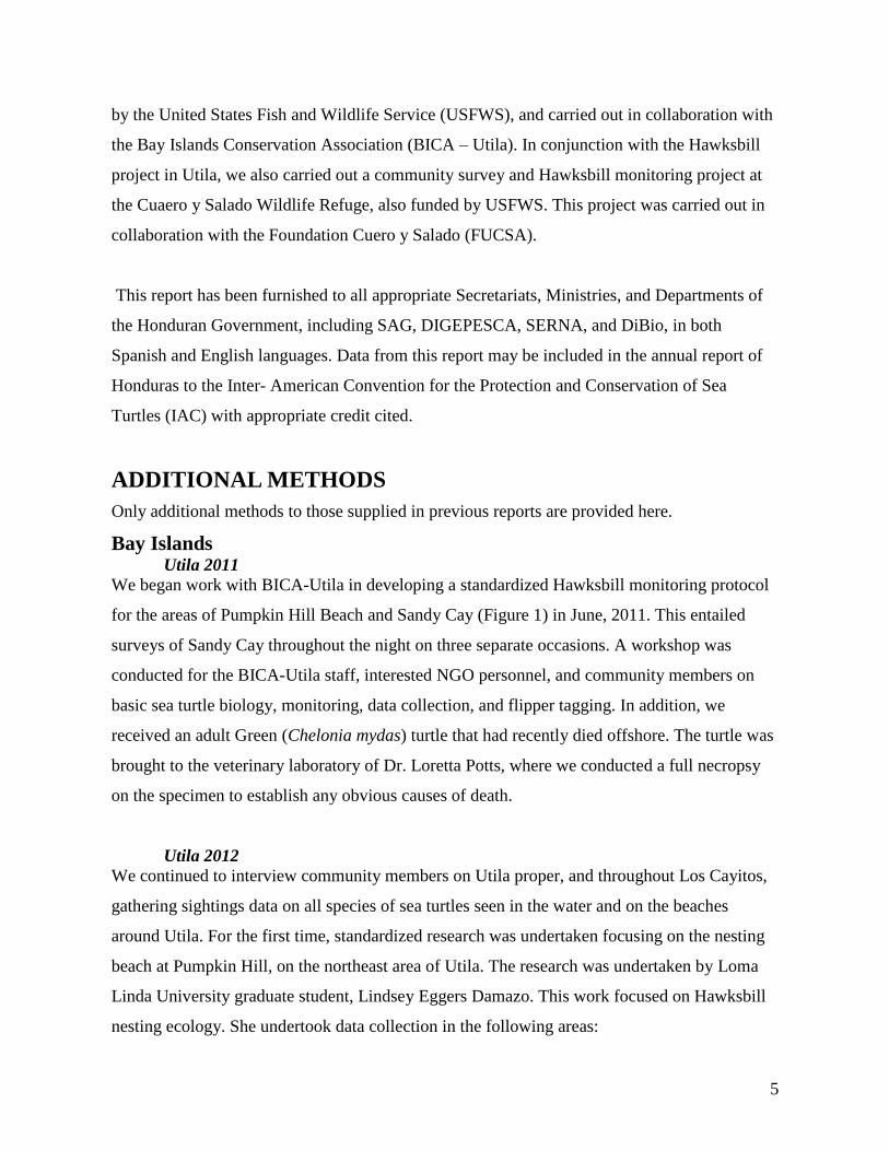
We began work with BICA-Utila in developing a standardized Hawksbill monitoring protocol
for the areas of Pumpkin Hill Beach and Sandy Cay (Figure 1) in June, 2011. This entailed
surveys of Sandy Cay throughout the night on three separate occasions. A workshop was
conducted for the BICA-Utila staff, interested NGO personnel, and community members on
basic sea turtle biology, monitoring, data collection, and flipper tagging. In addition, we
received an adult Green (Chelonia mydas) turtle that had recently died offshore. The turtle was
brought to the veterinary laboratory of Dr. Loretta Potts, where we conducted a full necropsy
on the specimen to establish any obvious causes of death.
Utila 2012
We continued to interview community members on Utila proper, and throughout Los Cayitos,
gathering sightings data on all species of sea turtles seen in the water and on the beaches
around Utila. For the first time, standardized research was undertaken focusing on the nesting
beach at Pumpkin Hill, on the northeast area of Utila. The research was undertaken by Loma
Linda University graduate student, Lindsey Eggers Damazo. This work focused on Hawksbill
nesting ecology. She undertook data collection in the following areas:
6
ambient temperatures of nests and pseudo-nests (controls) during incubation period
intra-nesting period returns of flipper-tagged individuals
satellite telemetry
sex ratios of hatchlings through blood sampling
beach profiling and vegetation characterizations
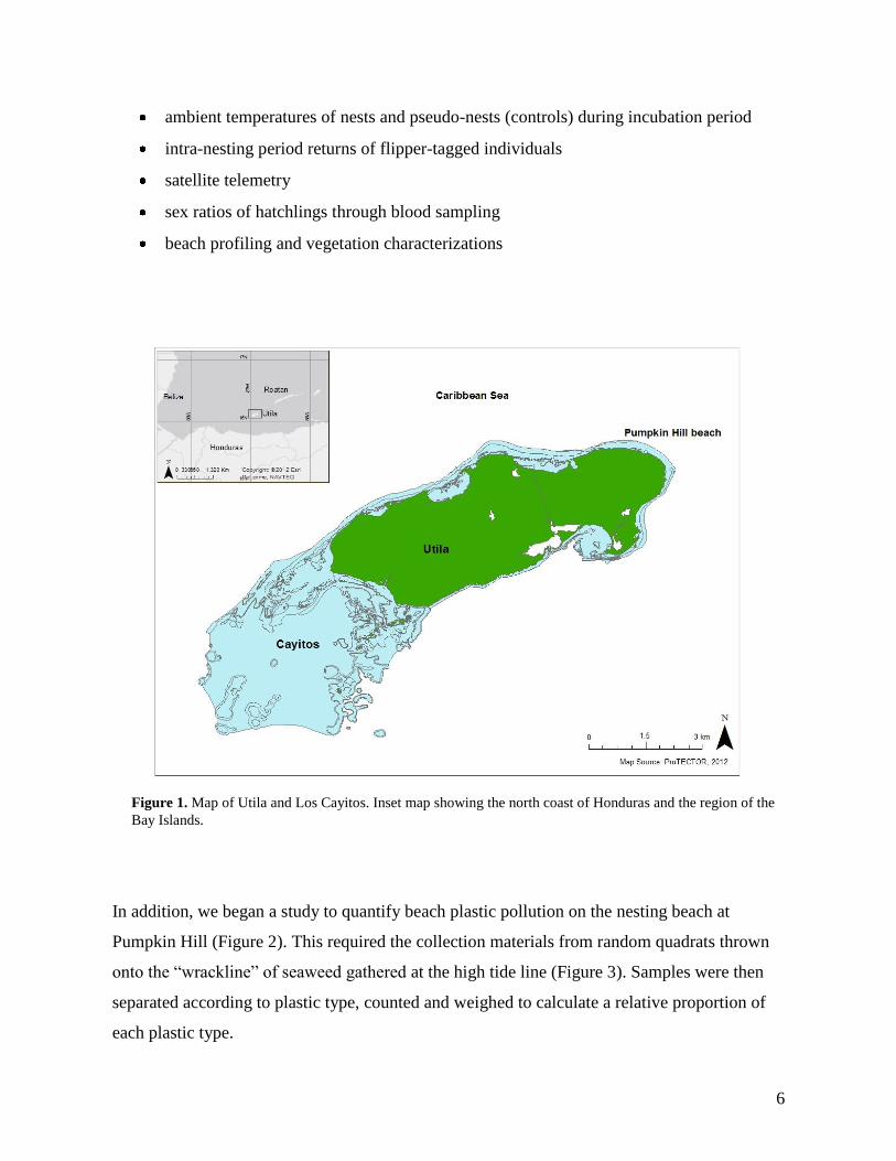
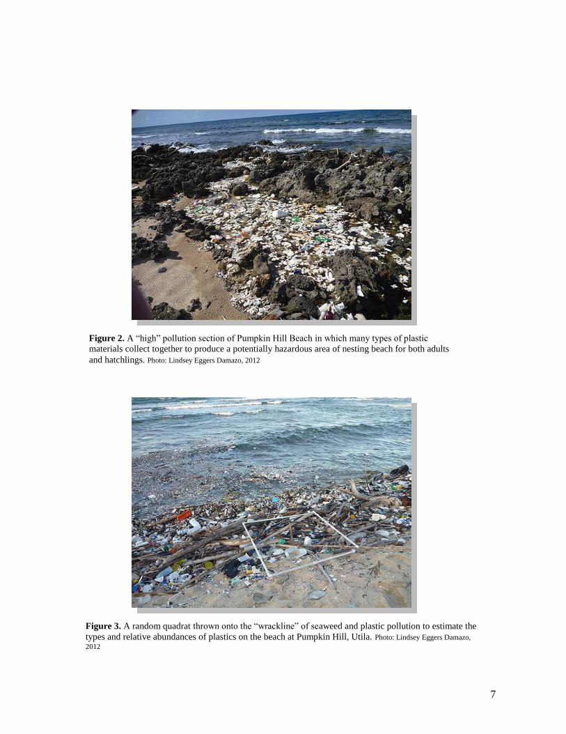
In addition, we began a study to quantify beach plastic pollution on the nesting beach at
Pumpkin Hill (Figure 2). This required the collection materials from random quadrats thrown
onto the “wrackline” of seaweed gathered at the high tide line (Figure 3). Samples were then
separated according to plastic type, counted and weighed to calculate a relative proportion of
each plastic type.
Figure 1. Map of Utila and Los Cayitos. Inset map showing the north coast of Honduras and the region of the
Bay Islands.
7
Figure 2. A “high” pollution section of Pumpkin Hill Beach in which many types of plastic
materials collect together to produce a potentially hazardous area of nesting beach for both adults
and hatchlings. Photo: Lindsey Eggers Damazo, 2012
Figure 3. A random quadrat thrown onto the “wrackline” of seaweed and plastic pollution to estimate the
types and relative abundances of plastics on the beach at Pumpkin Hill, Utila. Photo: Lindsey Eggers Damazo,
2012
8
Roatán 2011
In 2011, we continued work on the island of Roatán in the area of the Reef House Resort,
CocoView Resort and Fantasy Island Resort along the south coast of the island. From June –
September, we undertook hand captures of adult and juvenile Hawksbills in the area of CoCo
View and Fantasy Island Resorts during sport diving events. Turtles were brought on board,
and transported to the resorts where they were measured, flipper tagged on the right front and
right rear flippers, and had skin tissue sampled for genetic analyses, as per protocols for
previous studies in the Bay Islands (Dunbar, 2006; Dunbar and Berube, 2008; Dunbar et al.,
2008). We also undertook reef transects in the area of dive sites shared by the two resorts in
order to assess habitat suitability for resident or transient Hawksbills. Additionally, some
turtles were fitted with radio and sonic transmitters to record locations for estimating home
ranges.
Roatán 2012
We were unable to undertake any tagging in Roatán during 2012 due to logistical constraints
and due to a change in management at the Reef House Resort that did not facilitate our work
there during the regular summer season of turtle research.
Guanaja 2011
From October 2 – 5, a scouting team met with local community members to undertake casual
interviews to determine where sea turtles have been and are currently being sighted around
Guanaja. Community members were asked where they sighted turtles both in the water and on
the beaches. We visited sites around the main island and throughout the nearby cays. We also
attended a regional meeting and presented information on marine biodiversity and marine
protected areas. We interviewed the owners of a private cay nearby Banaca Cay, to ascertain if
regular nesting events were taking place on the Cay.
Guanaja 2012
We were unable to return to Guanaja in 2012. However, we had provided data sheets to the
owners of the Cay for them to record turtle nesting and hatching events during the 2012 nesting
season. We also provided materials for them to be able to identify the species of turtles nesting
on the Cay.
9
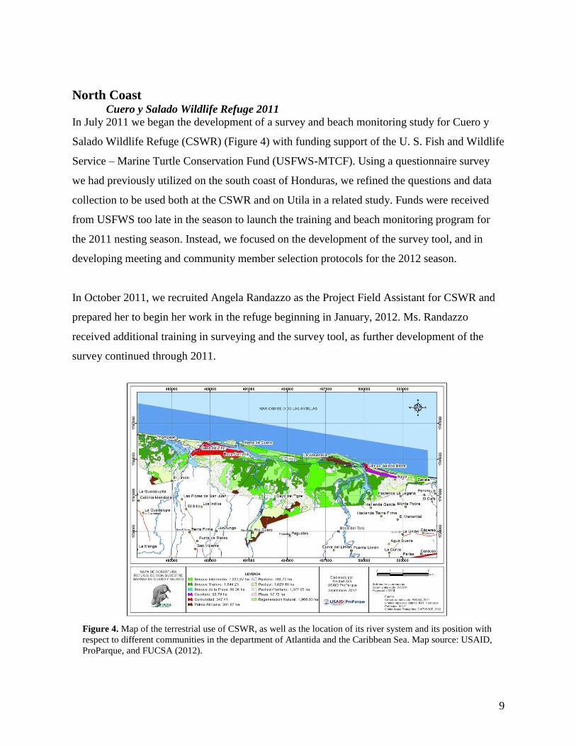
North Coast Cuero y Salado Wildlife Refuge 2011
In July 2011 we began the development of a survey and beach monitoring study for Cuero y
Salado Wildlife Refuge (CSWR) (Figure 4) with funding support of the U. S. Fish and Wildlife
Service – Marine Turtle Conservation Fund (USFWS-MTCF). Using a questionnaire survey
we had previously utilized on the south coast of Honduras, we refined the questions and data
collection to be used both at the CSWR and on Utila in a related study. Funds were received
from USFWS too late in the season to launch the training and beach monitoring program for
the 2011 nesting season. Instead, we focused on the development of the survey tool, and in
developing meeting and community member selection protocols for the 2012 season.
In October 2011, we recruited Angela Randazzo as the Project Field Assistant for CSWR and
prepared her to begin her work in the refuge beginning in January, 2012. Ms. Randazzo
received additional training in surveying and the survey tool, as further development of the
survey continued through 2011.
Figure 4. Map of the terrestrial use of CSWR, as well as the location of its river system and its position with
respect to different communities in the department of Atlantida and the Caribbean Sea. Map source: USAID,
ProParque, and FUCSA (2012).
10
Cuero y Salado Wildlife Refuge, 2012
Survey interviews with community members at CSWR were conducted from February to
April, 2012. Subsequent to interviews, we conducted in-water point monitoring and nesting
beach monitoring from June 27 to August 26. Due to expense, in-water beach monitoring was
limited to five weeks between the end of June and the end of August, and limited to irregular
times when trained fishers were able to collect data while undertaking artisanal fishing
activities.
Beach monitoring consisted of walking the beach to the East (East Beach) or West (West
Beach) of the beach entrance at Salado Bar during the overnight hours from 6:00pm to 4:00am.
Two teams undertook the monitoring of the same side of the beach (East or West), with one
team monitoring the far portion, while the other team monitored the near portion, with each
team covering an approximately 2.5 km section of beach. Night monitoring also included
capacity building and training of accompanying military and refuge guard personnel, as well as
young people from the community of Salado Bar. Additionally, beach monitoring also took
place on alternate days to night monitoring, to search for the presence of tracks left by either
nesting females, or hatchlings along the beach. We recorded the presence of turtles, turtle
tracks, evidence of nests, and turtle morphometrics (curved and straight carapace lengths and
width), as well as latitude and longitude of nests or turtle sightings, along with date, time,
flipper tag number and data recording team. Environmental conditions, such as sea state, rain
or storm conditions, and approximate temperature, were also recorded on encountering a turtle
or nest.
Surveys were also conducted to gather data on beach slope, condition, and vegetation cover of
both the East and West sectors of the beach. We used the polar line level method described by
Mossa (1998) to survey the height dynamics of the beach, then plotted these data in a grid
system using MatLab software (MathWorks Inc.; Natick, MA) to devise a profile of the beach.
Digital photographs were taken of each plant species for identification. Further detailed
methods can be found in Dunbar, et al. (2013).
11
South Coast Punta Ratón 2011
In 2011, we continued to undertake flipper tagging at Punta Ratón, along with the collection of
data on hatchling dynamics on release from the hatchery beach. Tagging and tissue sampling
followed procedures described previously in other reports (Dunbar et al., 2009; Dunbar et al.,
2010; Dunbar et al., 2011).
In addition, we undertook studies on predation rates of hatchlings released from the beach
during the night and during the day. Hatchlings were followed by boat and sighted with the use
of a modified Witherington float (with a glow stick at night, or a yellow balloon during the
day) for up to 6 hours. A GPS was used to record the location of the hatchling every 5 minutes.
These points, and any attempted predation events were recorded and plotted in a GIS.
A preliminary study was undertaken examining swimming behavior of hatchlings at night
compared with swimming behavior during the day, by releasing hatchlings with modified
Witherington floats, following hatchling movements, and recording hatchling position in the
water over periods of up to 8 hours. Hatchlings were released from different positions along
the length of beach. These data were recorded with a GPS and plotted in a GIS to identify
trajectories of hatchlings as they swam away from the release beach.
Punta Ratón 2012
In 2012, we continued the studies begun in 2011 with both nesting adults and hatchlings.
During the nesting and hatching seasons from August to November, we carried out replicated
experiments on hatchlings to determine the impacts of tides on hatchlings released from both
the site of the hatchery and from the area where turtles laid most of the nests on the beach
during 2012. We also assessed hatchling swimming pattern and hatchling predation through
focal follows over different tidal regimes and over periods of up to 12 hours at a time.
Hatchlings were released with a modified Witherington float and followed by boat from a
distance of 50 – 80 meters. At 5 minute intervals, the boat was brought to the location of the
hatchling (indicated by either the glow stick (night), or the balloon (day)), and a location was
recorded with a GPS.
12
In addition, we began tracking nesting females to determine inter-nesting movements of select
females by using cell phone-based data loggers (Global Tracking Group, Baltimore, MD). Data
loggers were placed in small buoys tethered to individual turtles with fishing line and tracked
in real-time. We also collected blood and skin samples from as many nesting adults as possible.
El Venado 2011
At El Venado, we expanded our flipper tagging efforts for Lepidochelys olivacea to extend
through the entire 25 day period of the veda from September 1 – 25. During this period, we
collected measurements (SCL, SCW, CCL, CCW) of each female encountered and recorded
location (GPS), number of eggs deposited, date, time, and whether there were previous tagging
records or indications of previous flipper tags. Work was conducted with the collaboration of
the community of El Venado, who collected eggs during the veda to place into the hatchery at
the Turtle Conservation Center.
In addition, we collected blood and skin samples from as many nesting females as possible to
later be used for population genetic analyses. These samples were stored in cell lysis buffer and
brought back to the United States under appropriate CITES export and import permits.
As part of our continuing effort to determine migratory pathways of sea turtles to and from
Honduras, we fitted two nesting Olive ridleys (“Tenita” and “Brenda”) with Spot 5 satellite
transmitters and released them from the main beach at El Venado. These turtles were then
tracked by satellite and their movements plotted by the Satellite Tracking and Analysis Tool
(STAT), which can be found at: http://www.seaturtle.org/tracking/ .
El Venado 2012
We continued to work alongside the community of El Venado in developing infrastructure and
providing social assistance to the community in the context of sea turtle conservation. This
effort led to the partnership of ProTECTOR with the Global Health Institute (GHI) at LLU and
the Students for International Mission Service (SIMS) at LLU, and culminated in the first
SIMS trip from LLU to the south coast of Honduras.
13
We continued to flipper tag nesting Olive Ridleys in the area of El Venado throughout the veda
period, including the collection of additional blood samples for genetic analyses, and the
launching of additional satellite tags on “Reina-Christiana,” “Sabine,” and “Loanis.”
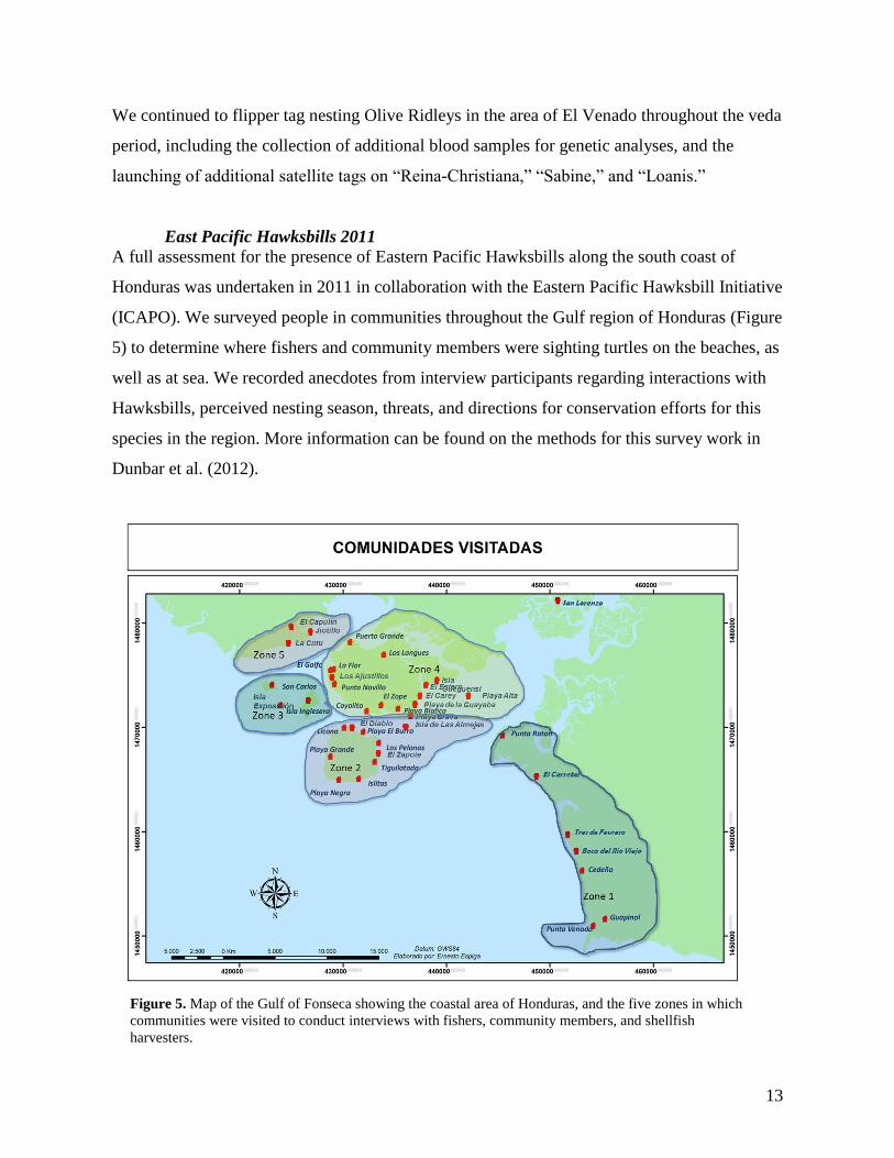
East Pacific Hawksbills 2011
A full assessment for the presence of Eastern Pacific Hawksbills along the south coast of
Honduras was undertaken in 2011 in collaboration with the Eastern Pacific Hawksbill Initiative
(ICAPO). We surveyed people in communities throughout the Gulf region of Honduras (Figure
5) to determine where fishers and community members were sighting turtles on the beaches, as
well as at sea. We recorded anecdotes from interview participants regarding interactions with
Hawksbills, perceived nesting season, threats, and directions for conservation efforts for this
species in the region. More information can be found on the methods for this survey work in
Dunbar et al. (2012).
Figure 5. Map of the Gulf of Fonseca showing the coastal area of Honduras, and the five zones in which
communities were visited to conduct interviews with fishers, community members, and shellfish
harvesters.
14
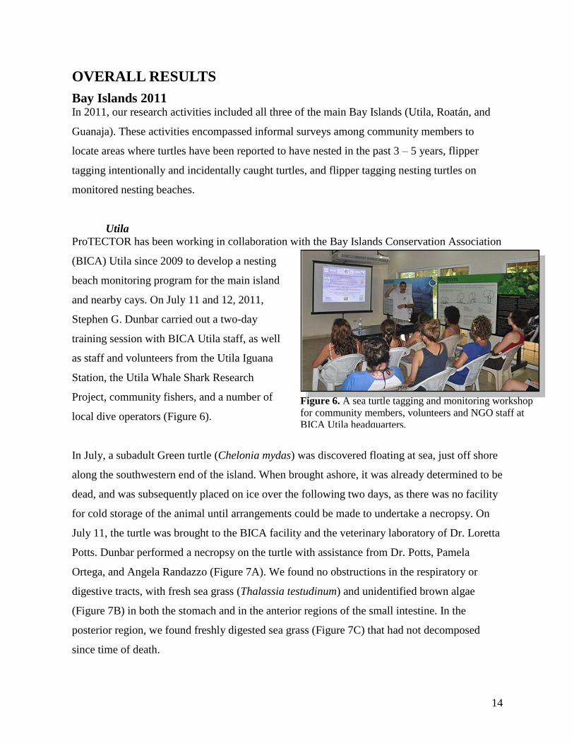
Figure 6. A sea turtle tagging and monitoring workshop
for community members, volunteers and NGO staff at
BICA Utila headquarters.
OVERALL RESULTS
Bay Islands 2011 In 2011, our research activities included all three of the main Bay Islands (Utila, Roatán, and
Guanaja). These activities encompassed informal surveys among community members to
locate areas where turtles have been reported to have nested in the past 3 – 5 years, flipper
tagging intentionally and incidentally caught turtles, and flipper tagging nesting turtles on
monitored nesting beaches.
Utila
ProTECTOR has been working in collaboration with the Bay Islands Conservation Association
(BICA) Utila since 2009 to develop a nesting
beach monitoring program for the main island
and nearby cays. On July 11 and 12, 2011,
Stephen G. Dunbar carried out a two-day
training session with BICA Utila staff, as well
as staff and volunteers from the Utila Iguana
Station, the Utila Whale Shark Research
Project, community fishers, and a number of
local dive operators (Figure 6).
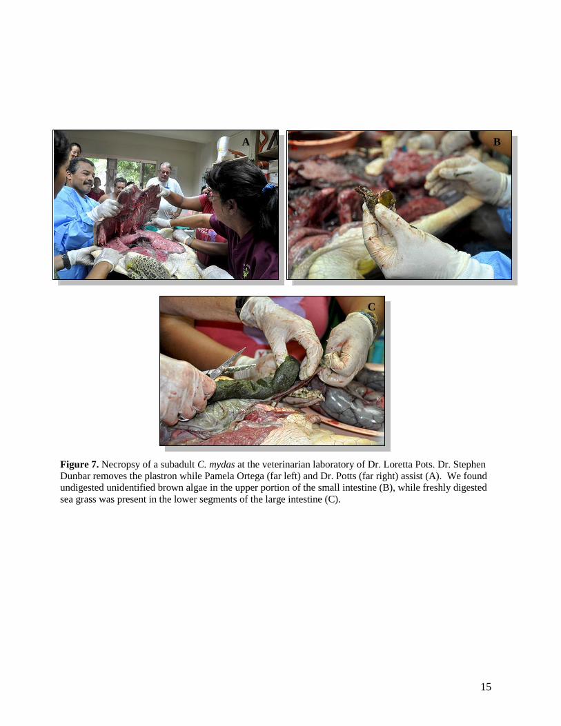
In July, a subadult Green turtle (Chelonia mydas) was discovered floating at sea, just off shore
along the southwestern end of the island. When brought ashore, it was already determined to be
dead, and was subsequently placed on ice over the following two days, as there was no facility
for cold storage of the animal until arrangements could be made to undertake a necropsy. On
July 11, the turtle was brought to the BICA facility and the veterinary laboratory of Dr. Loretta
Potts. Dunbar performed a necropsy on the turtle with assistance from Dr. Potts, Pamela
Ortega, and Angela Randazzo (Figure 7A). We found no obstructions in the respiratory or
digestive tracts, with fresh sea grass (Thalassia testudinum) and unidentified brown algae
(Figure 7B) in both the stomach and in the anterior regions of the small intestine. In the
posterior region, we found freshly digested sea grass (Figure 7C) that had not decomposed
since time of death.
15
A B
C
Figure 7. Necropsy of a subadult C. mydas at the veterinarian laboratory of Dr. Loretta Pots. Dr. Stephen
Dunbar removes the plastron while Pamela Ortega (far left) and Dr. Potts (far right) assist (A). We found
undigested unidentified brown algae in the upper portion of the small intestine (B), while freshly digested
sea grass was present in the lower segments of the large intestine (C).
16
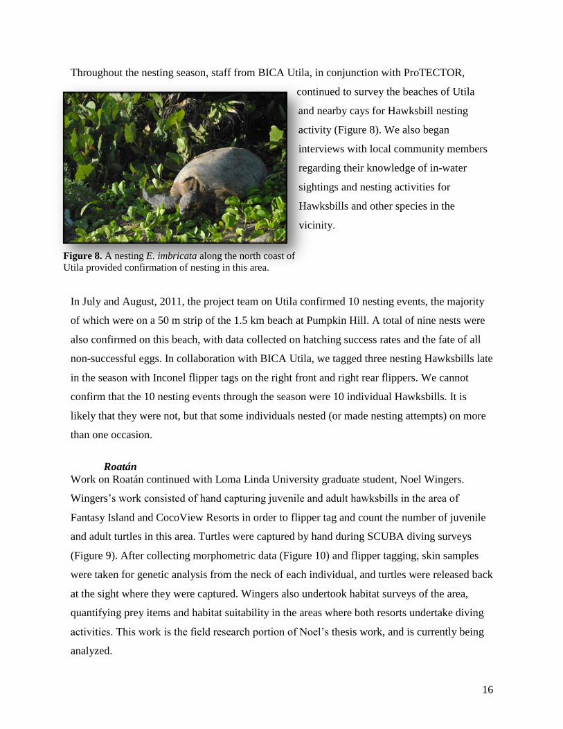
Figure 8. A nesting E. imbricata along the north coast of
Utila provided confirmation of nesting in this area.
Throughout the nesting season, staff from BICA Utila, in conjunction with ProTECTOR,
continued to survey the beaches of Utila
and nearby cays for Hawksbill nesting
activity (Figure 8). We also began
interviews with local community members
regarding their knowledge of in-water
sightings and nesting activities for
Hawksbills and other species in the
vicinity.
In July and August, 2011, the project team on Utila confirmed 10 nesting events, the majority
of which were on a 50 m strip of the 1.5 km beach at Pumpkin Hill. A total of nine nests were
also confirmed on this beach, with data collected on hatching success rates and the fate of all
non-successful eggs. In collaboration with BICA Utila, we tagged three nesting Hawksbills late
in the season with Inconel flipper tags on the right front and right rear flippers. We cannot
confirm that the 10 nesting events through the season were 10 individual Hawksbills. It is
likely that they were not, but that some individuals nested (or made nesting attempts) on more
than one occasion.
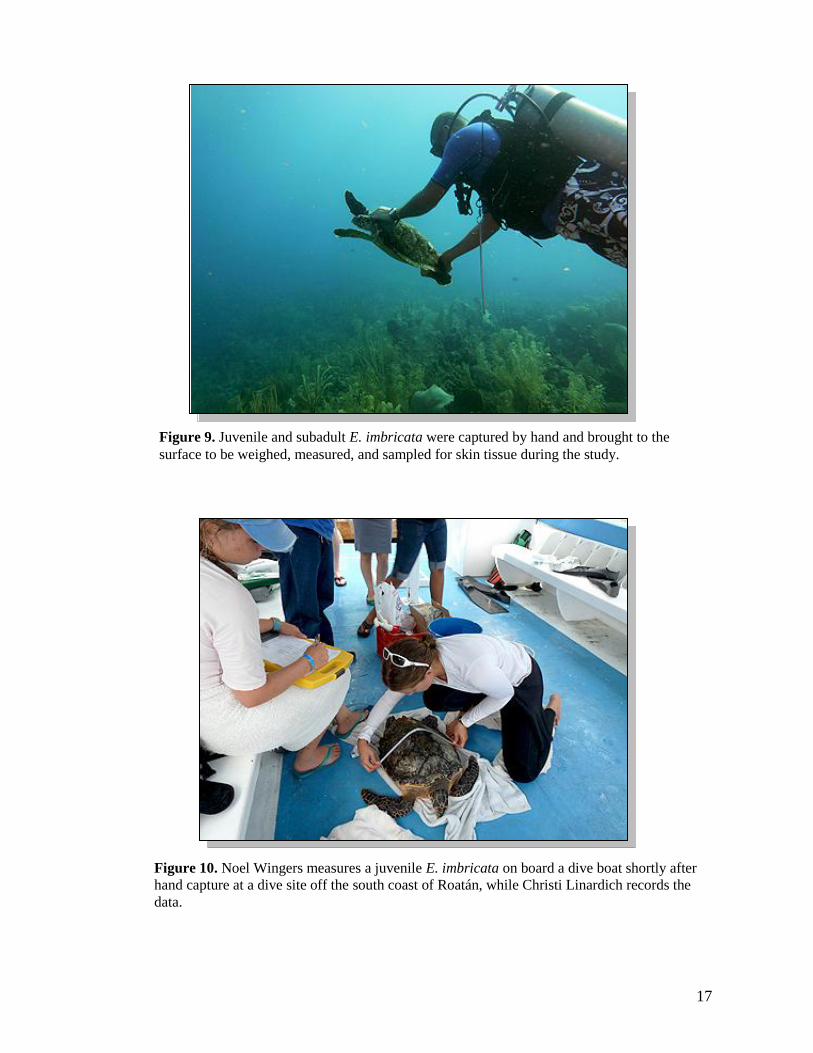
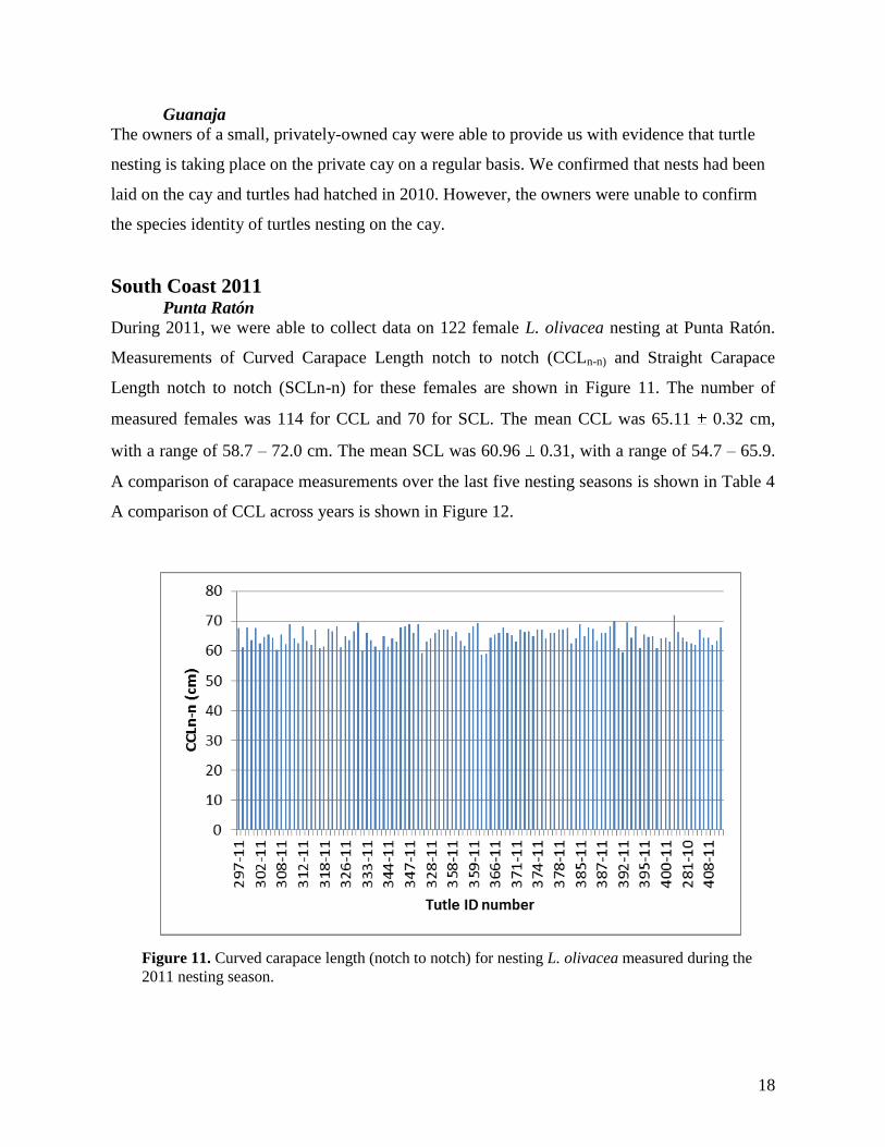
Roatán
Work on Roatán continued with Loma Linda University graduate student, Noel Wingers.
Wingers’s work consisted of hand capturing juvenile and adult hawksbills in the area of
Fantasy Island and CocoView Resorts in order to flipper tag and count the number of juvenile
and adult turtles in this area. Turtles were captured by hand during SCUBA diving surveys
(Figure 9). After collecting morphometric data (Figure 10) and flipper tagging, skin samples
were taken for genetic analysis from the neck of each individual, and turtles were released back
at the sight where they were captured. Wingers also undertook habitat surveys of the area,
quantifying prey items and habitat suitability in the areas where both resorts undertake diving
activities. This work is the field research portion of Noel’s thesis work, and is currently being
analyzed.
17
Figure 9. Juvenile and subadult E. imbricata were captured by hand and brought to the
surface to be weighed, measured, and sampled for skin tissue during the study.
Figure 10. Noel Wingers measures a juvenile E. imbricata on board a dive boat shortly after
hand capture at a dive site off the south coast of Roatán, while Christi Linardich records the
data.
18
Guanaja
The owners of a small, privately-owned cay were able to provide us with evidence that turtle
nesting is taking place on the private cay on a regular basis. We confirmed that nests had been
laid on the cay and turtles had hatched in 2010. However, the owners were unable to confirm
the species identity of turtles nesting on the cay.
South Coast 2011 Punta Ratón
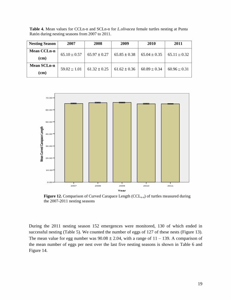
During 2011, we were able to collect data on 122 female L. olivacea nesting at Punta Ratón.
Measurements of Curved Carapace Length notch to notch (CCLn-n) and Straight Carapace
Length notch to notch (SCLn-n) for these females are shown in Figure 11. The number of
measured females was 114 for CCL and 70 for SCL. The mean CCL was 65.11 0.32 cm,
with a range of 58.7 – 72.0 cm. The mean SCL was 60.96 0.31, with a range of 54.7 – 65.9.
A comparison of carapace measurements over the last five nesting seasons is shown in Table 4
A comparison of CCL across years is shown in Figure 12.
Figure 11. Curved carapace length (notch to notch) for nesting L. olivacea measured during the
2011 nesting season.
19
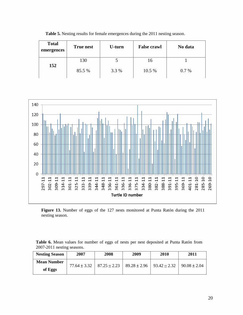
During the 2011 nesting season 152 emergences were monitored, 130 of which ended in
successful nesting (Table 5). We counted the number of eggs of 127 of these nests (Figure 13).
The mean value for egg number was 90.08 2.04, with a range of 11 – 139. A comparison of
the mean number of eggs per nest over the last five nesting seasons is shown in Table 6 and
Figure 14.
Nesting Season 2007 2008 2009 2010 2011
Mean CCLn-n
(cm) 65.10 0.57 65.97 0.27 65.85 0.38 65.04 0.35 65.11 0.32
Mean SCLn-n
(cm) 59.02 1.01 61.32 0.25 61.62 0.36 60.89 0.34 60.96 0.31
Table 4. Mean values for CCLn-n and SCLn-n for L.olivacea female turtles nesting at Punta
Ratón during nesting seasons from 2007 to 2011.
.
20112010200920082007
Year
70.00
60.00
50.00
40.00
30.00
20.00
10.00
0.00
Mea
n C
urve
d C
arap
ace
Leng
th
Figure 12. Comparison of Curved Carapace Length (CCLn-n) of turtles measured during
the 2007-2011 nesting seasons
20
Nesting Season 2007 2008 2009 2010 2011
Mean Number
of Eggs 77.64 3.32 87.25 2.23 89.28 2.96 93.42 2.32 90.08 2.04
Total
emergences True nest U-turn False crawl No data
152 130
85.5 %
5
3.3 %
16
10.5 %
1
0.7 %
Table 5. Nesting results for female emergences during the 2011 nesting season.
Figure 13. Number of eggs of the 127 nests monitored at Punta Ratón during the 2011
nesting season.
Table 6. Mean values for number of eggs of nests per nest deposited at Punta Ratón from
2007-2011 nesting seasons.
21
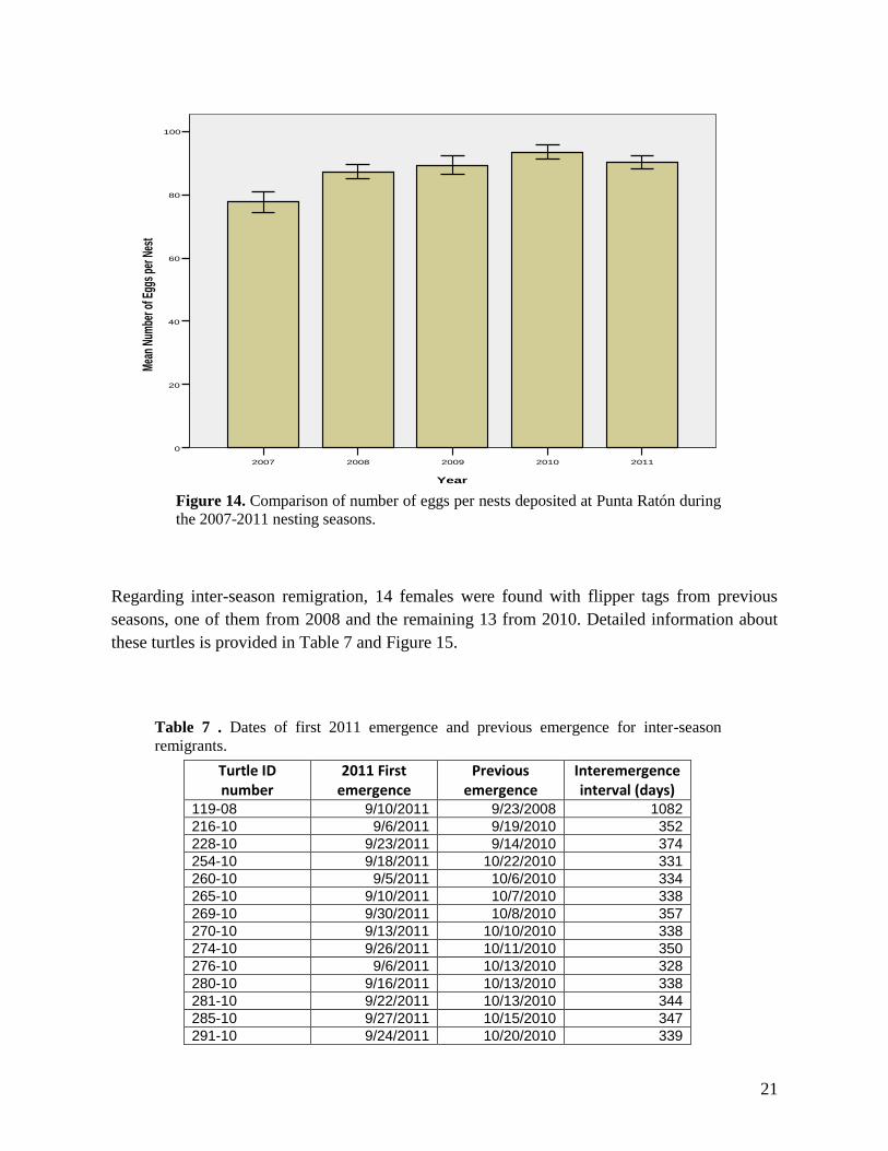
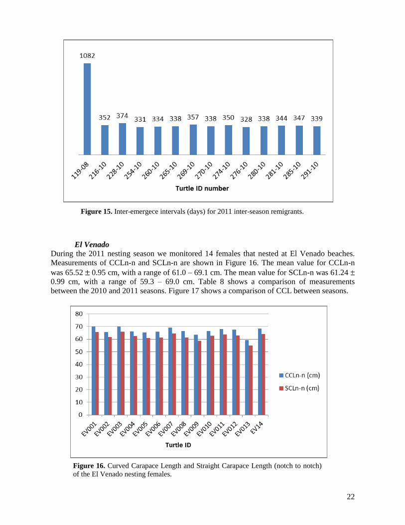
Regarding inter-season remigration, 14 females were found with flipper tags from previous
seasons, one of them from 2008 and the remaining 13 from 2010. Detailed information about
these turtles is provided in Table 7 and Figure 15.
Turtle ID number
2011 First emergence
Previous emergence
Interemergence interval (days)
119-08 9/10/2011 9/23/2008 1082
216-10 9/6/2011 9/19/2010 352
228-10 9/23/2011 9/14/2010 374
254-10 9/18/2011 10/22/2010 331
260-10 9/5/2011 10/6/2010 334
265-10 9/10/2011 10/7/2010 338
269-10 9/30/2011 10/8/2010 357
270-10 9/13/2011 10/10/2010 338
274-10 9/26/2011 10/11/2010 350
276-10 9/6/2011 10/13/2010 328
280-10 9/16/2011 10/13/2010 338
281-10 9/22/2011 10/13/2010 344
285-10 9/27/2011 10/15/2010 347
291-10 9/24/2011 10/20/2010 339
20112010200920082007
Year
100
80
60
40
20
0
Mea
n Nu
mbe
r of E
ggs
per N
est
Figure 14. Comparison of number of eggs per nests deposited at Punta Ratón during
the 2007-2011 nesting seasons.
Table 7 . Dates of first 2011 emergence and previous emergence for inter-season
remigrants.
22
El Venado
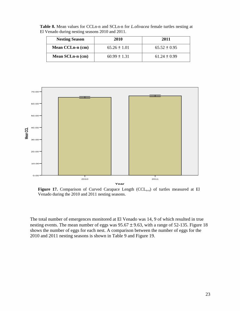
During the 2011 nesting season we monitored 14 females that nested at El Venado beaches.
Measurements of CCLn-n and SCLn-n are shown in Figure 16. The mean value for CCLn-n
was 65.52 0.95 cm, with a range of 61.0 – 69.1 cm. The mean value for SCLn-n was 61.24
0.99 cm, with a range of 59.3 – 69.0 cm. Table 8 shows a comparison of measurements
between the 2010 and 2011 seasons. Figure 17 shows a comparison of CCL between seasons.
Figure 15. Inter-emergece intervals (days) for 2011 inter-season remigrants.
Figure 16. Curved Carapace Length and Straight Carapace Length (notch to notch)
of the El Venado nesting females.
23
Nesting Season 2010 2011
Mean CCLn-n (cm) 65.26 1.01 65.52 0.95
Mean SCLn-n (cm) 60.99 1.31 61.24 0.99
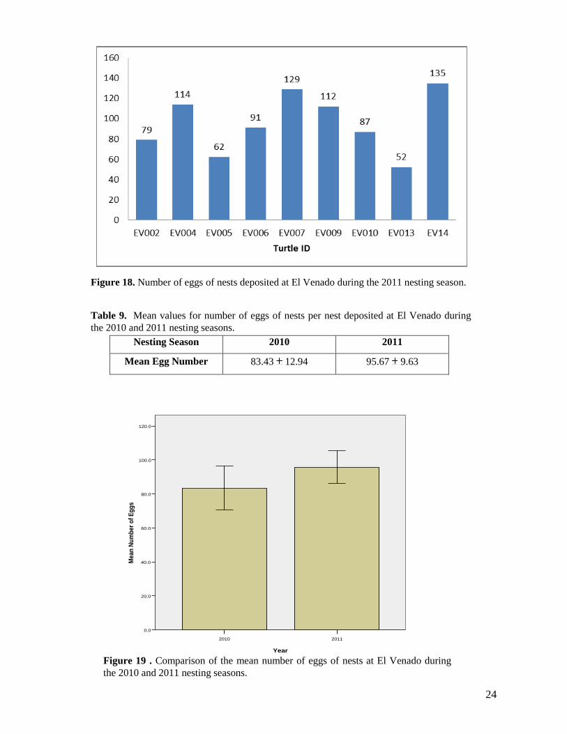
The total number of emergences monitored at El Venado was 14, 9 of which resulted in true
nesting events. The mean number of eggs was 95.67 9.63, with a range of 52-135. Figure 18
shows the number of eggs for each nest. A comparison between the number of eggs for the
2010 and 2011 nesting seasons is shown in Table 9 and Figure 19.
Table 8. Mean values for CCLn-n and SCLn-n for L.olivacea female turtles nesting at
El Venado during nesting seasons 2010 and 2011.
20112010
Year
70.00
60.00
50.00
40.00
30.00
20.00
10.00
0.00
Mean
CCL
Figure 17. Comparison of Curved Carapace Length (CCLn-n) of turtles measured at El
Venado during the 2010 and 2011 nesting seasons.
24
Nesting Season 2010 2011
Mean Egg Number 83.43 12.94 95.67 9.63
Figure 18. Number of eggs of nests deposited at El Venado during the 2011 nesting season.
Table 9. Mean values for number of eggs of nests per nest deposited at El Venado during
the 2010 and 2011 nesting seasons.
20112010
Year
120.0
100.0
80.0
60.0
40.0
20.0
0.0
Mean
Nu
mb
er o
f E
gg
s
Figure 19 . Comparison of the mean number of eggs of nests at El Venado during
the 2010 and 2011 nesting seasons.
25
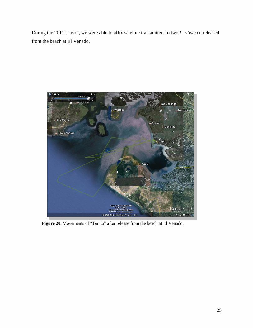
During the 2011 season, we were able to affix satellite transmitters to two L. olivacea released
from the beach at El Venado.
Figure 20. Movements of “Tenita” after release from the beach at El Venado.
26
East Pacific Hawksbills
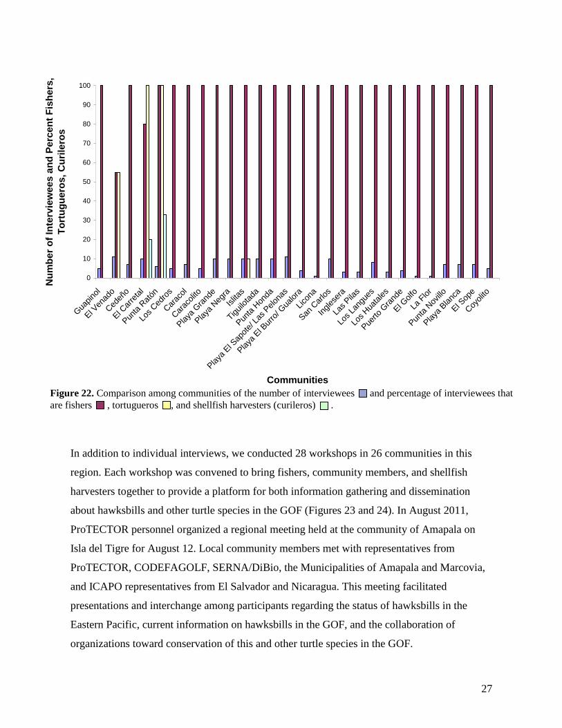
We conducted a region-wide survey of communities along the South Coast of Honduras in the
Gulf of Fonseca in which we undertook 181 formal interviews in 28 communities. Interviews
were conducted with local fishers, community members, Tortugueros, and shellfish harvesters.
When occupations were compared among communities (Figure 22), we found the majority of
interviewees were fishers, and that few interviewees were shellfish harvesters. Thus far,
interviews with shellfish harvesters have only been undertaken in El Carretal and Punta Ratón.
In contrast to the communities of El Venado, El Carretal, Punta Ratón, and Islitas, fishers in
the majority of communities are not involved as Tortugueros in sea turtle conservation.
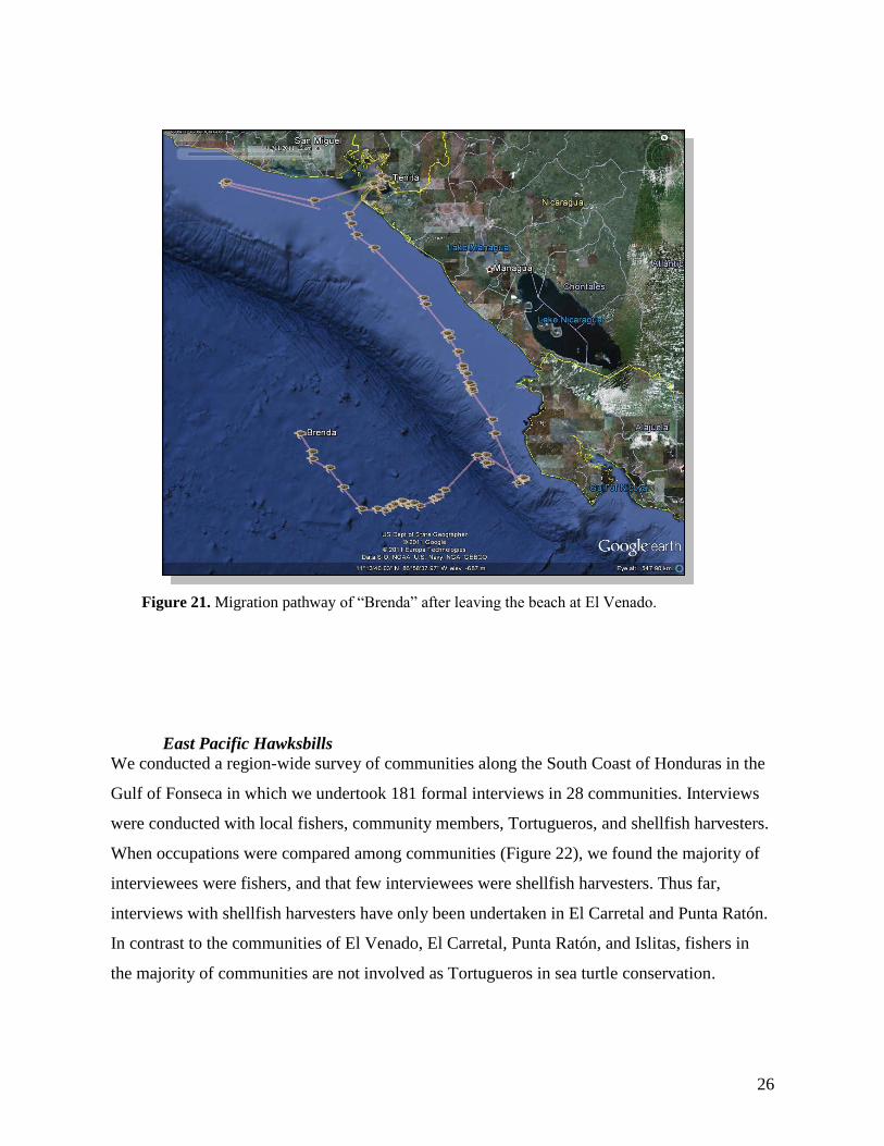
Figure 21. Migration pathway of “Brenda” after leaving the beach at El Venado.
27
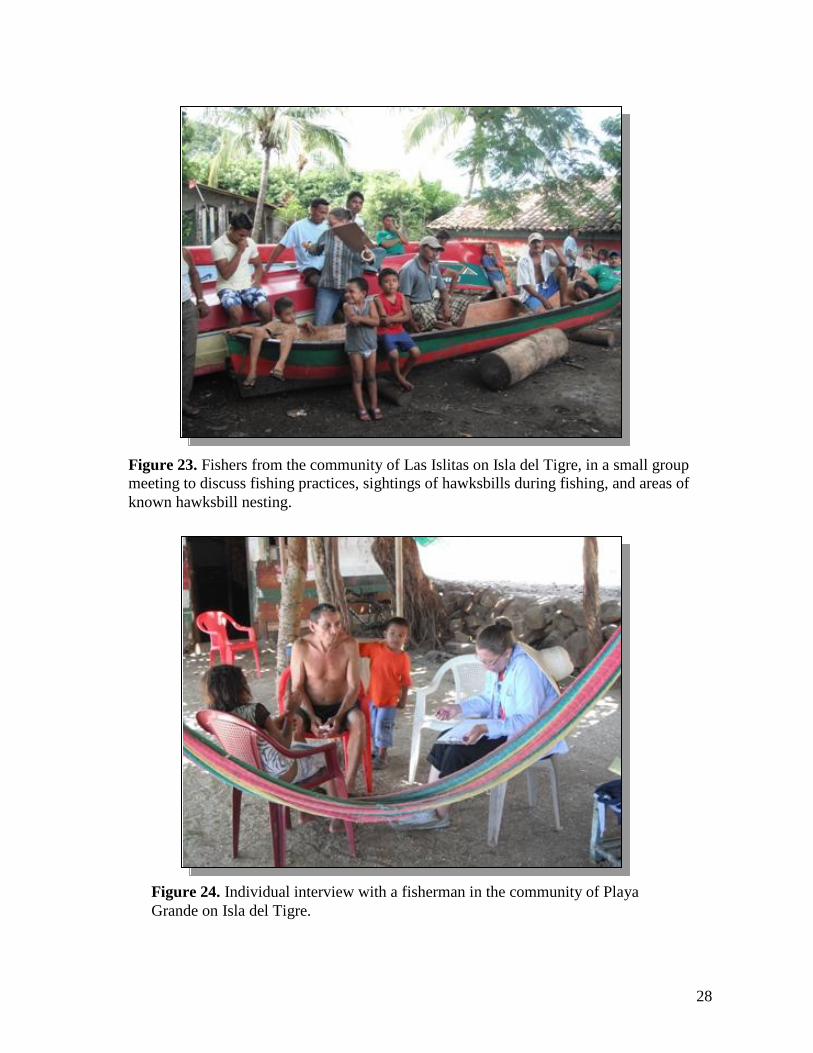
In addition to individual interviews, we conducted 28 workshops in 26 communities in this
region. Each workshop was convened to bring fishers, community members, and shellfish
harvesters together to provide a platform for both information gathering and dissemination
about hawksbills and other turtle species in the GOF (Figures 23 and 24). In August 2011,
ProTECTOR personnel organized a regional meeting held at the community of Amapala on
Isla del Tigre for August 12. Local community members met with representatives from
ProTECTOR, CODEFAGOLF, SERNA/DiBio, the Municipalities of Amapala and Marcovia,
and ICAPO representatives from El Salvador and Nicaragua. This meeting facilitated
presentations and interchange among participants regarding the status of hawksbills in the
Eastern Pacific, current information on hawksbills in the GOF, and the collaboration of
organizations toward conservation of this and other turtle species in the GOF.
0
10
20
30
40
50
60
70
80
90
100
Gua
pino
l
El V
enad
o
Ced
eño
El C
arre
tal
Pun
ta R
atón
Los Ced
ros
Car
acol
Car
acolito
Playa
Gra
nde
Playa
Neg
ra
Islitas
Tiguilota
da
Pun
ta H
onda
Playa
El S
apot
e/ L
as P
elon
as
Playa
El B
urro
/ Gua
lora
Lico
na
San
Car
los
Ingles
era
Las Pila
s
Los La
ngue
s
Los Hua
tales
Pue
rto G
rand
e
El G
olfo
La F
lor
Pun
ta N
ovillo
Playa
Blanc
a
El S
ope
Coy
olito
Communities
Nu
mb
er
of
Inte
rvie
we
es
an
d P
erc
en
t F
ish
ers
,
To
rtu
gu
ero
s,
Cu
rile
ros
Figure 22. Comparison among communities of the number of interviewees and percentage of interviewees that
are fishers , tortugueros , and shellfish harvesters (curileros) .
28
Figure 24. Individual interview with a fisherman in the community of Playa
Grande on Isla del Tigre.
Figure 23. Fishers from the community of Las Islitas on Isla del Tigre, in a small group
meeting to discuss fishing practices, sightings of hawksbills during fishing, and areas of
known hawksbill nesting.
29
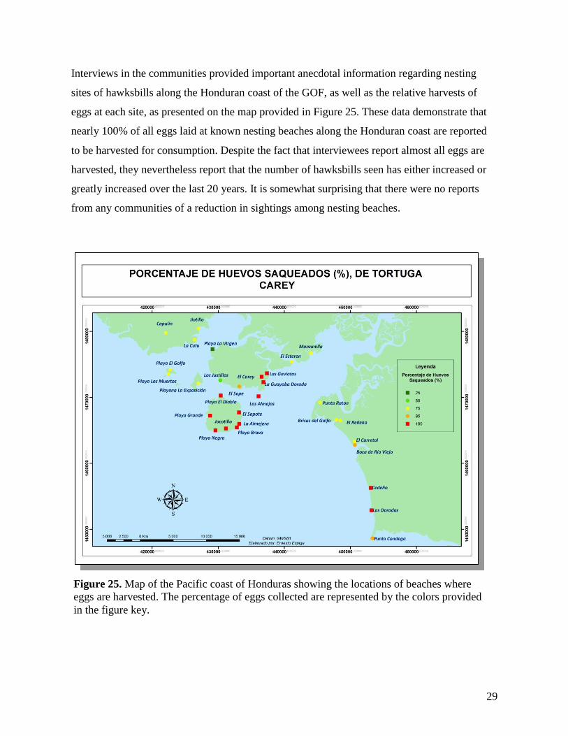
Interviews in the communities provided important anecdotal information regarding nesting
sites of hawksbills along the Honduran coast of the GOF, as well as the relative harvests of
eggs at each site, as presented on the map provided in Figure 25. These data demonstrate that
nearly 100% of all eggs laid at known nesting beaches along the Honduran coast are reported
to be harvested for consumption. Despite the fact that interviewees report almost all eggs are
harvested, they nevertheless report that the number of hawksbills seen has either increased or
greatly increased over the last 20 years. It is somewhat surprising that there were no reports
from any communities of a reduction in sightings among nesting beaches.
Figure 25. Map of the Pacific coast of Honduras showing the locations of beaches where
eggs are harvested. The percentage of eggs collected are represented by the colors provided
in the figure key.
30
Peak nesting months appear to differ slightly among nesting beaches in the five zones and
among communities. However, the main months reported for nesting hawksbills in this region
are May through October.
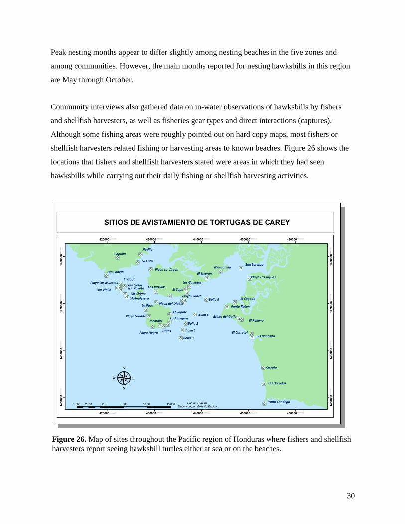
Community interviews also gathered data on in-water observations of hawksbills by fishers
and shellfish harvesters, as well as fisheries gear types and direct interactions (captures).
Although some fishing areas were roughly pointed out on hard copy maps, most fishers or
shellfish harvesters related fishing or harvesting areas to known beaches. Figure 26 shows the
locations that fishers and shellfish harvesters stated were areas in which they had seen
hawksbills while carrying out their daily fishing or shellfish harvesting activities.
Figure 26. Map of sites throughout the Pacific region of Honduras where fishers and shellfish
harvesters report seeing hawksbill turtles either at sea or on the beaches.
31
It is apparent, from responses of interviewees to date, that many of hawksbills incidentally
captured by fishers are reported to be released. However, interviewees from the communities
of Playa El Gulfo (San Carlos), El Venado, and Los Justillos, in the Municipality of Amapala,
reported that hawksbills caught by fishers were often consumed. Observations reported by
fishers suggest, overall, that fishers see hawksbills throughout the entire year. However, the
communities of Las Doradas, Cedeño, and Estero Punta Raton mainly sight hawksbills in the
months from June to November.
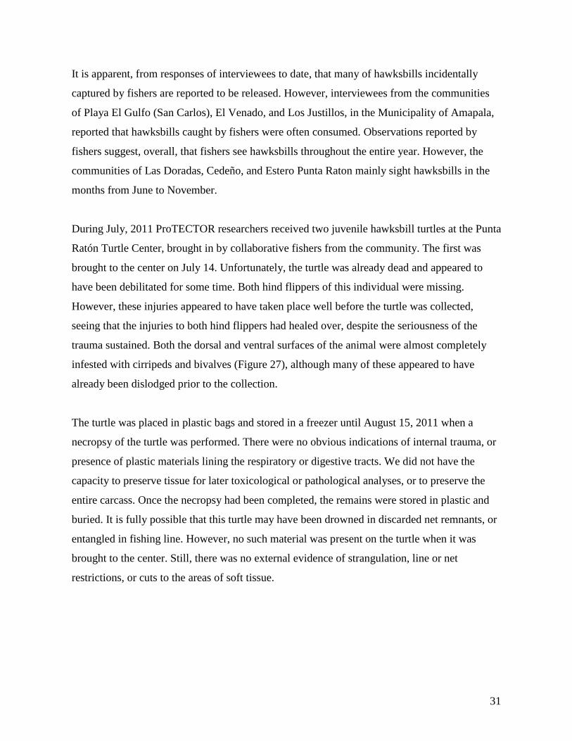
During July, 2011 ProTECTOR researchers received two juvenile hawksbill turtles at the Punta
Ratón Turtle Center, brought in by collaborative fishers from the community. The first was
brought to the center on July 14. Unfortunately, the turtle was already dead and appeared to
have been debilitated for some time. Both hind flippers of this individual were missing.
However, these injuries appeared to have taken place well before the turtle was collected,
seeing that the injuries to both hind flippers had healed over, despite the seriousness of the
trauma sustained. Both the dorsal and ventral surfaces of the animal were almost completely
infested with cirripeds and bivalves (Figure 27), although many of these appeared to have
already been dislodged prior to the collection.
The turtle was placed in plastic bags and stored in a freezer until August 15, 2011 when a
necropsy of the turtle was performed. There were no obvious indications of internal trauma, or
presence of plastic materials lining the respiratory or digestive tracts. We did not have the
capacity to preserve tissue for later toxicological or pathological analyses, or to preserve the
entire carcass. Once the necropsy had been completed, the remains were stored in plastic and
buried. It is fully possible that this turtle may have been drowned in discarded net remnants, or
entangled in fishing line. However, no such material was present on the turtle when it was
brought to the center. Still, there was no external evidence of strangulation, line or net
restrictions, or cuts to the areas of soft tissue.
32
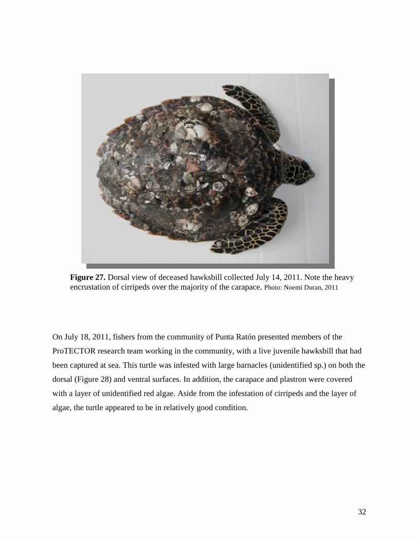
On July 18, 2011, fishers from the community of Punta Ratón presented members of the
ProTECTOR research team working in the community, with a live juvenile hawksbill that had
been captured at sea. This turtle was infested with large barnacles (unidentified sp.) on both the
dorsal (Figure 28) and ventral surfaces. In addition, the carapace and plastron were covered
with a layer of unidentified red algae. Aside from the infestation of cirripeds and the layer of
algae, the turtle appeared to be in relatively good condition.
Figure 27. Dorsal view of deceased hawksbill collected July 14, 2011. Note the heavy
encrustation of cirripeds over the majority of the carapace. Photo: Noemi Duran, 2011
33
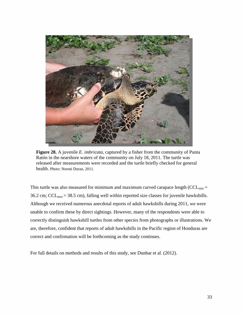
This turtle was also measured for minimum and maximum curved carapace length (CCLmin =
36.2 cm; CCLmax = 38.5 cm), falling well within reported size classes for juvenile hawksbills.
Although we received numerous anecdotal reports of adult hawksbills during 2011, we were
unable to confirm these by direct sightings. However, many of the respondents were able to
correctly distinguish hawksbill turtles from other species from photographs or illustrations. We
are, therefore, confident that reports of adult hawksbills in the Pacific region of Honduras are
correct and confirmation will be forthcoming as the study continues.
For full details on methods and results of this study, see Dunbar et al. (2012).
Figure 28. A juvenile E. imbricata, captured by a fisher from the community of Punta
Ratón in the nearshore waters of the community on July 18, 2011. The turtle was
released after measurements were recorded and the turtle briefly checked for general
health. Photo: Noemi Duran, 2011.
34
Bay Islands 2012 Utila
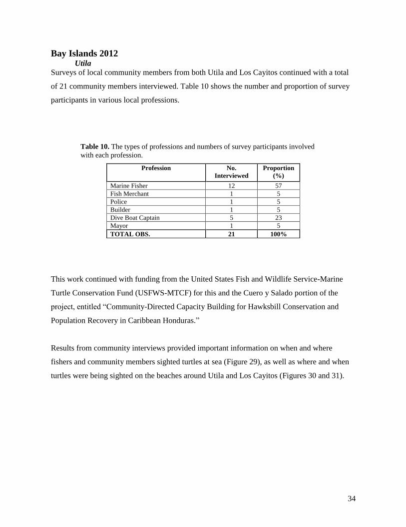
Surveys of local community members from both Utila and Los Cayitos continued with a total
of 21 community members interviewed. Table 10 shows the number and proportion of survey
participants in various local professions.
This work continued with funding from the United States Fish and Wildlife Service-Marine
Turtle Conservation Fund (USFWS-MTCF) for this and the Cuero y Salado portion of the
project, entitled “Community-Directed Capacity Building for Hawksbill Conservation and
Population Recovery in Caribbean Honduras.”
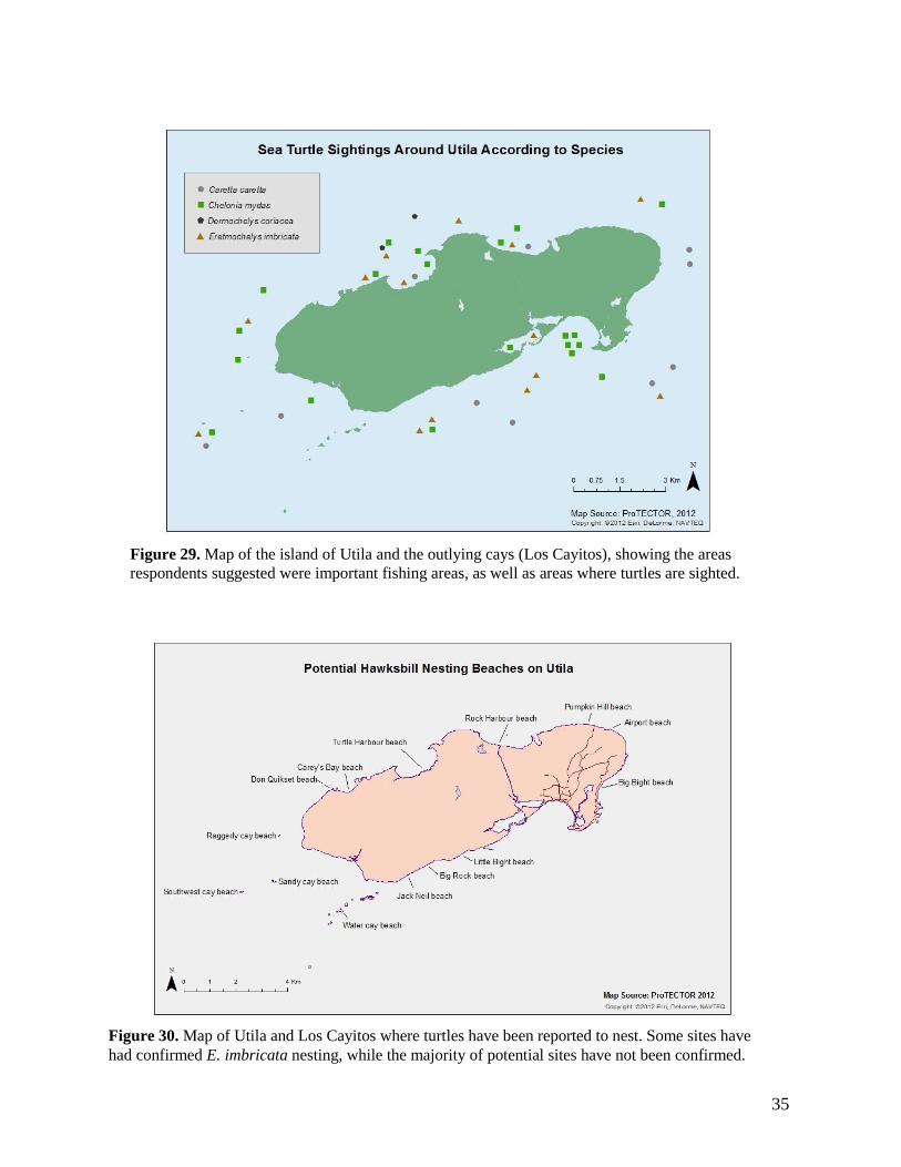
Results from community interviews provided important information on when and where
fishers and community members sighted turtles at sea (Figure 29), as well as where and when
turtles were being sighted on the beaches around Utila and Los Cayitos (Figures 30 and 31).
Profession No.
Interviewed
Proportion
(%)
Marine Fisher 12 57
Fish Merchant 1 5
Police 1 5
Builder 1 5
Dive Boat Captain 5 23
Mayor 1 5
TOTAL OBS. 21 100%
Table 10. The types of professions and numbers of survey participants involved
with each profession.
35
Figure 29. Map of the island of Utila and the outlying cays (Los Cayitos), showing the areas
respondents suggested were important fishing areas, as well as areas where turtles are sighted.
Figure 30. Map of Utila and Los Cayitos where turtles have been reported to nest. Some sites have
had confirmed E. imbricata nesting, while the majority of potential sites have not been confirmed.
36
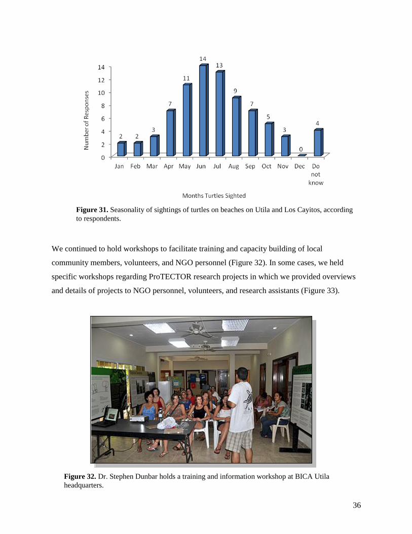
We continued to hold workshops to facilitate training and capacity building of local
community members, volunteers, and NGO personnel (Figure 32). In some cases, we held
specific workshops regarding ProTECTOR research projects in which we provided overviews
and details of projects to NGO personnel, volunteers, and research assistants (Figure 33).
Figure 31. Seasonality of sightings of turtles on beaches on Utila and Los Cayitos, according
to respondents.
Figure 32. Dr. Stephen Dunbar holds a training and information workshop at BICA Utila
headquarters.
37
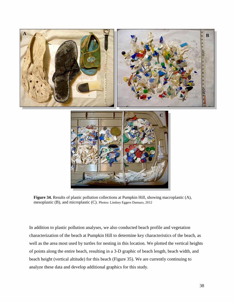
During the 2012 season, we also undertook the initial portion of a study to quantify plastic
beach pollution on the nesting beach at Pumpkin Hill. We collected as much material as
possible from quadrates randomly thrown on the wrackline. Samples were taken to the
laboratory where they were separated according to plastic type, and weighed to calculate the
relative weight per sample of each type of plastic material. The initial study resulted in the
collection of many types of plastic pollution materials, from macroplastics (shoes and bottle
seen in Figure 34A), and mesoplastics (portions of larger plastic pollution, including caps,
tubes, and utensils shown in Figure 34B), to microplastics (brittle and broken fragments of
plastic materials, as seen in Figure 34C). All portions of materials were weighed and
quantified. However, we are currently analyzing these results.
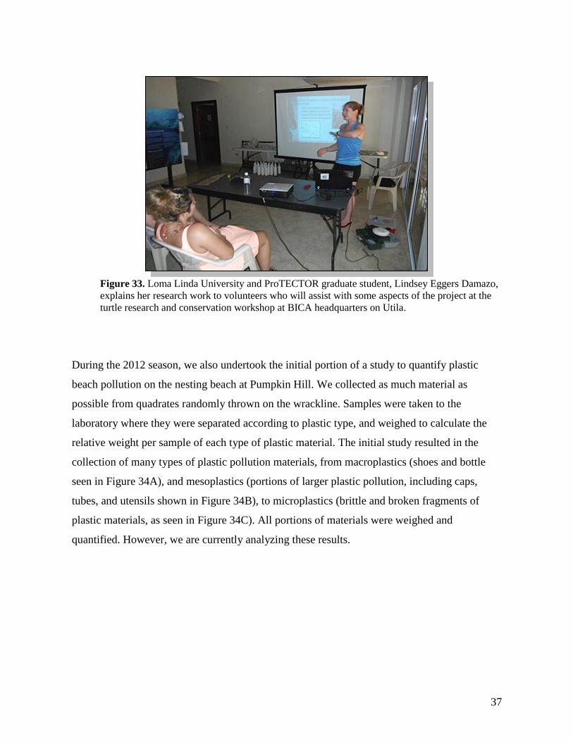
Figure 33. Loma Linda University and ProTECTOR graduate student, Lindsey Eggers Damazo,
explains her research work to volunteers who will assist with some aspects of the project at the
turtle research and conservation workshop at BICA headquarters on Utila.
38
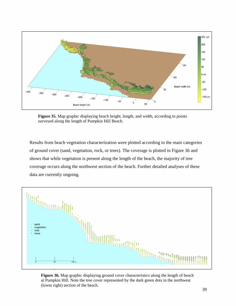
In addition to plastic pollution analyses, we also conducted beach profile and vegetation
characterization of the beach at Pumpkin Hill to determine key characteristics of the beach, as
well as the area most used by turtles for nesting in this location. We plotted the vertical heights
of points along the entire beach, resulting in a 3-D graphic of beach length, beach width, and
beach height (vertical altitude) for this beach (Figure 35). We are currently continuing to
analyze these data and develop additional graphics for this study.
A B
C
Figure 34. Results of plastic pollution collections at Pumpkin Hill, showing macroplastic (A),
mesoplastic (B), and microplastic (C). Photos: Lindsey Eggers Damazo, 2012
39
Results from beach vegetation characterization were plotted according to the main categories
of ground cover (sand, vegetation, rock, or trees). The coverage is plotted in Figure 36 and
shows that while vegetation is present along the length of the beach, the majority of tree
coverage occurs along the northwest section of the beach. Further detailed analyses of these
data are currently ongoing.
We were able to fix satellite transmitters (Wildlife Computers, Spot 5) to two nesting
Hawksbills. The first was placed on “Chel” on July 11, 2012 (Fig. 129). Shortly after being
fitted with the transmitter, this turtle began to move northwest, away from Utila and toward the
coast of Belize. The turtle stayed east of the coast of Belize until coming to the area of Corazal,
where she then hugged the coastline making her way further north along the coastal zone of
Quintana Roo. Chel eventually stopped at Cayo Culebra in the Sian-Ka’an Biosphere Reserve,
just south of Cozumel (see Fig. 131). The transmitter signal was eventually lost after 90 days
on October 9, 2012.
Figure 35. Map graphic displaying beach height, length, and width, according to points
surveyed along the length of Pumpkin Hill Beach.
Figure 36. Map graphic displaying ground cover characteristics along the length of beach
at Pumpkin Hill. Note the tree cover represented by the dark green dots in the northwest
(lower right) section of the beach.
40
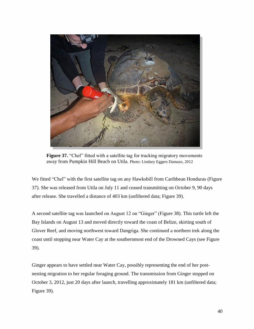
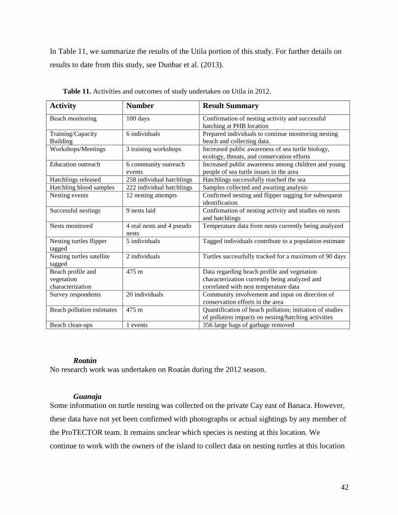
We fitted “Chel” with the first satellite tag on any Hawksbill from Caribbean Honduras (Figure
37). She was released from Utila on July 11 and ceased transmitting on October 9, 90 days
after release. She travelled a distance of 403 km (unfiltered data; Figure 39).
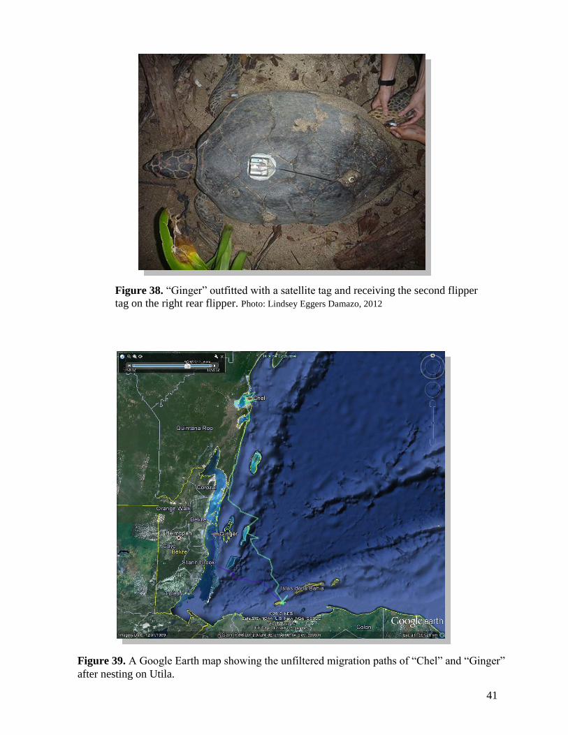
A second satellite tag was launched on August 12 on “Ginger” (Figure 38). This turtle left the
Bay Islands on August 13 and moved directly toward the coast of Belize, skirting south of
Glover Reef, and moving northwest toward Dangriga. She continued a northern trek along the
coast until stopping near Water Cay at the southernmost end of the Drowned Cays (see Figure
39).
Ginger appears to have settled near Water Cay, possibly representing the end of her post-
nesting migration to her regular foraging ground. The transmission from Ginger stopped on
October 3, 2012, just 20 days after launch, travelling approximately 181 km (unfiltered data;
Figure 39).
Figure 37. “Chel” fitted with a satellite tag for tracking migratory movements
away from Pumpkin Hill Beach on Utila. Photo: Lindsey Eggers Damazo, 2012
41
Figure 39. A Google Earth map showing the unfiltered migration paths of “Chel” and “Ginger”
after nesting on Utila.
Figure 38. “Ginger” outfitted with a satellite tag and receiving the second flipper
tag on the right rear flipper. Photo: Lindsey Eggers Damazo, 2012
42
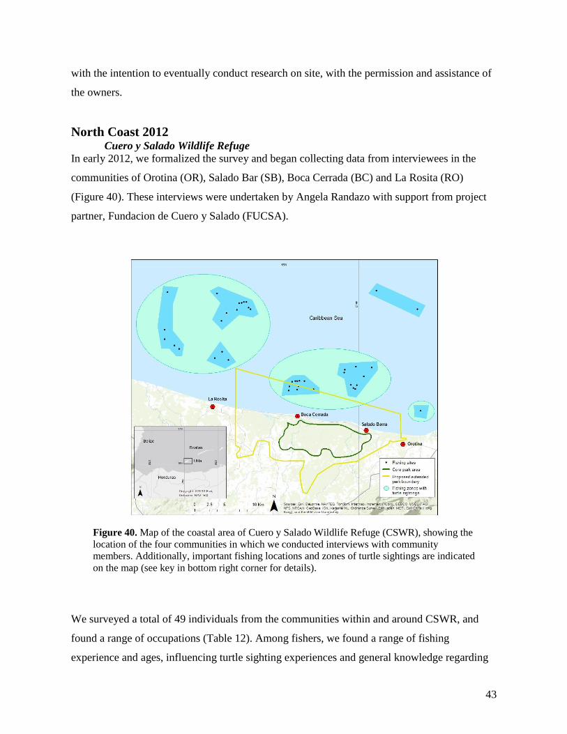
In Table 11, we summarize the results of the Utila portion of this study. For further details on
results to date from this study, see Dunbar et al. (2013).
Activity Number Result Summary
Beach monitoring 100 days Confirmation of nesting activity and successful
hatching at PHB location
Training/Capacity
Building
6 individuals Prepared individuals to continue monitoring nesting
beach and collecting data.
Workshops/Meetings 3 training workshops Increased public awareness of sea turtle biology,
ecology, threats, and conservation efforts
Education outreach 6 community outreach
events
Increased public awareness among children and young
people of sea turtle issues in the area
Hatchlings released 258 individual hatchlings Hatchlings successfully reached the sea
Hatchling blood samples 222 individual hatchlings Samples collected and awaiting analysis
Nesting events 12 nesting attempts Confirmed nesting and flipper tagging for subsequent
identification.
Successful nestings 9 nests laid Confirmation of nesting activity and studies on nests
and hatchlings
Nests monitored 4 real nests and 4 pseudo
nests
Temperature data from nests currently being analyzed
Nesting turtles flipper
tagged
5 individuals Tagged individuals contribute to a population estimate
Nesting turtles satellite
tagged
2 individuals Turtles successfully tracked for a maximum of 90 days
Beach profile and
vegetation
characterization
475 m Data regarding beach profile and vegetation
characterization currently being analyzed and
correlated with nest temperature data
Survey respondents 20 individuals Community involvement and input on direction of
conservation efforts in the area
Beach pollution estimates 475 m Quantification of beach pollution; initiation of studies
of pollution impacts on nesting/hatching activities
Beach clean-ups 1 events 356 large bags of garbage removed
Roatán
No research work was undertaken on Roatán during the 2012 season.
Guanaja
Some information on turtle nesting was collected on the private Cay east of Banaca. However,
these data have not yet been confirmed with photographs or actual sightings by any member of
the ProTECTOR team. It remains unclear which species is nesting at this location. We
continue to work with the owners of the island to collect data on nesting turtles at this location
Table 11. Activities and outcomes of study undertaken on Utila in 2012.
43
with the intention to eventually conduct research on site, with the permission and assistance of
the owners.
North Coast 2012 Cuero y Salado Wildlife Refuge
In early 2012, we formalized the survey and began collecting data from interviewees in the
communities of Orotina (OR), Salado Bar (SB), Boca Cerrada (BC) and La Rosita (RO)
(Figure 40). These interviews were undertaken by Angela Randazo with support from project
partner, Fundacion de Cuero y Salado (FUCSA).
We surveyed a total of 49 individuals from the communities within and around CSWR, and
found a range of occupations (Table 12). Among fishers, we found a range of fishing
experience and ages, influencing turtle sighting experiences and general knowledge regarding
Figure 40. Map of the coastal area of Cuero y Salado Wildlife Refuge (CSWR), showing the
location of the four communities in which we conducted interviews with community
members. Additionally, important fishing locations and zones of turtle sightings are indicated
on the map (see key in bottom right corner for details).
44
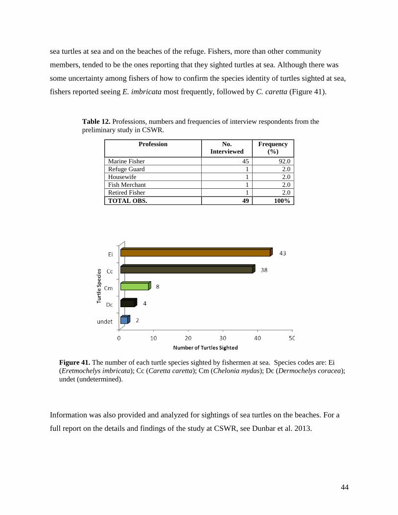
sea turtles at sea and on the beaches of the refuge. Fishers, more than other community
members, tended to be the ones reporting that they sighted turtles at sea. Although there was
some uncertainty among fishers of how to confirm the species identity of turtles sighted at sea,
fishers reported seeing E. imbricata most frequently, followed by C. caretta (Figure 41).
Information was also provided and analyzed for sightings of sea turtles on the beaches. For a
full report on the details and findings of the study at CSWR, see Dunbar et al. 2013.
Profession No.
Interviewed
Frequency
(%)
Marine Fisher 45 92.0
Refuge Guard 1 2.0
Housewife 1 2.0
Fish Merchant 1 2.0
Retired Fisher 1 2.0
TOTAL OBS. 49 100%
Table 12. Professions, numbers and frequencies of interview respondents from the
preliminary study in CSWR.
Figure 41. The number of each turtle species sighted by fishermen at sea. Species codes are: Ei
(Eretmochelys imbricata); Cc (Caretta caretta); Cm (Chelonia mydas); Dc (Dermochelys coracea);
undet (undetermined).
45
Data collection was accompanied by education outreach in each community school, providing
information about sea turtle ecology, and the importance of conservation efforts, such as those
undertaken by ProTECTOR. One outreach event included accompanying children from the
community of Salado Bar to La Ceiba, where they took part in a 2-day campaign on the
campus of El Centro Regional de Documentación e Interpretación Ambiental (CREDIA) to
raise the awareness of the general public regarding the Cuero y Salado Wildlife Refuge.
During the preliminary study from February to April, 2012, we conducted 6 night patrols over
a total of 14.5 hours and 29 km of beach. On March 27, 2012, on the beach between the
community and Salado Bar (western sector), we observed the successful nesting of a single
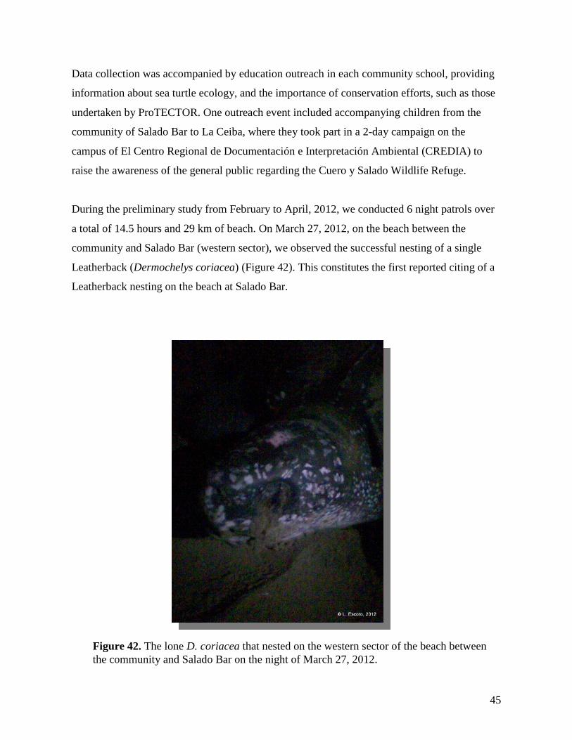
Leatherback (Dermochelys coriacea) (Figure 42). This constitutes the first reported citing of a
Leatherback nesting on the beach at Salado Bar.
Figure 42. The lone D. coriacea that nested on the western sector of the beach between
the community and Salado Bar on the night of March 27, 2012.
46
South Coast 2012 Punta Raton
ProTECTOR work at Punta Ratón continued through Loma Linda University graduate student,
Noemi Duran. During the 2012 nesting season, there were multiple issues of concern taking
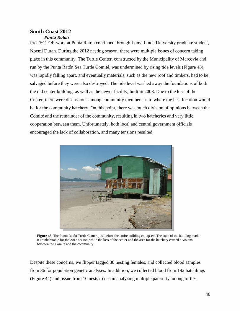
place in this community. The Turtle Center, constructed by the Municipality of Marcovia and
run by the Punta Ratón Sea Turtle Comité, was undermined by rising tide levels (Figure 43),
was rapidly falling apart, and eventually materials, such as the new roof and timbers, had to be
salvaged before they were also destroyed. The tide level washed away the foundations of both
the old center building, as well as the newer facility, built in 2008. Due to the loss of the
Center, there were discussions among community members as to where the best location would
be for the community hatchery. On this point, there was much division of opinions between the
Comité and the remainder of the community, resulting in two hatcheries and very little
cooperation between them. Unfortunately, both local and central government officials
encouraged the lack of collaboration, and many tensions resulted.
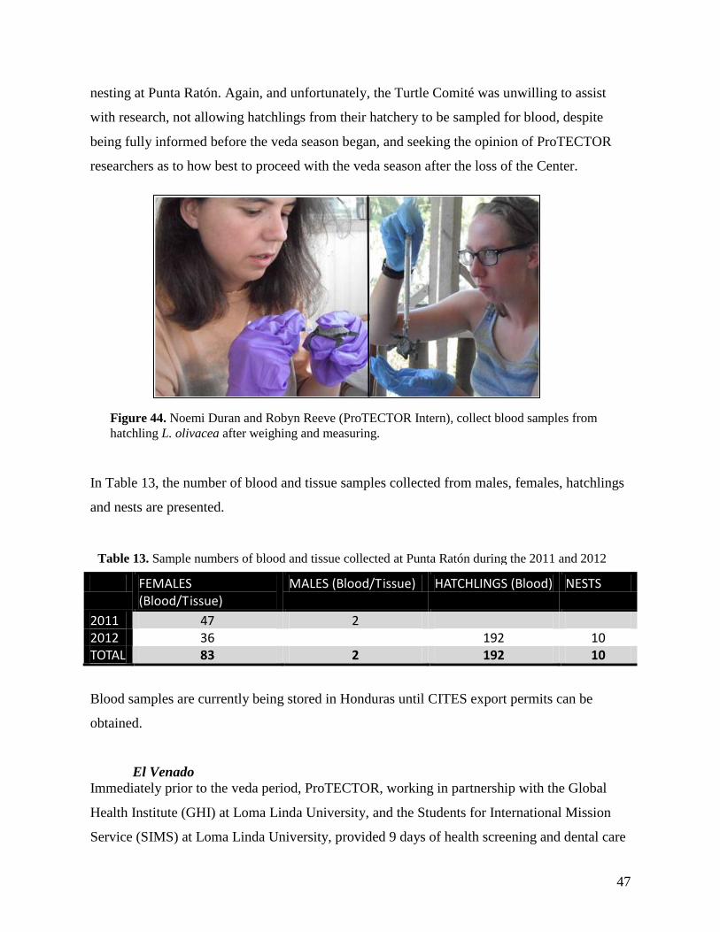
Despite these concerns, we flipper tagged 38 nesting females, and collected blood samples
from 36 for population genetic analyses. In addition, we collected blood from 192 hatchlings
(Figure 44) and tissue from 10 nests to use in analyzing multiple paternity among turtles
Figure 43. The Punta Ratón Turtle Center, just before the entire building collapsed. The state of the building made
it uninhabitable for the 2012 season, while the loss of the center and the area for the hatchery caused divisions
between the Comité and the community.
47
nesting at Punta Ratón. Again, and unfortunately, the Turtle Comité was unwilling to assist
with research, not allowing hatchlings from their hatchery to be sampled for blood, despite
being fully informed before the veda season began, and seeking the opinion of ProTECTOR
researchers as to how best to proceed with the veda season after the loss of the Center.
In Table 13, the number of blood and tissue samples collected from males, females, hatchlings
and nests are presented.
FEMALES (Blood/Tissue)
MALES (Blood/Tissue) HATCHLINGS (Blood) NESTS
2011 47 2 2012 36 192 10 TOTAL 83 2 192 10
Blood samples are currently being stored in Honduras until CITES export permits can be
obtained.
El Venado
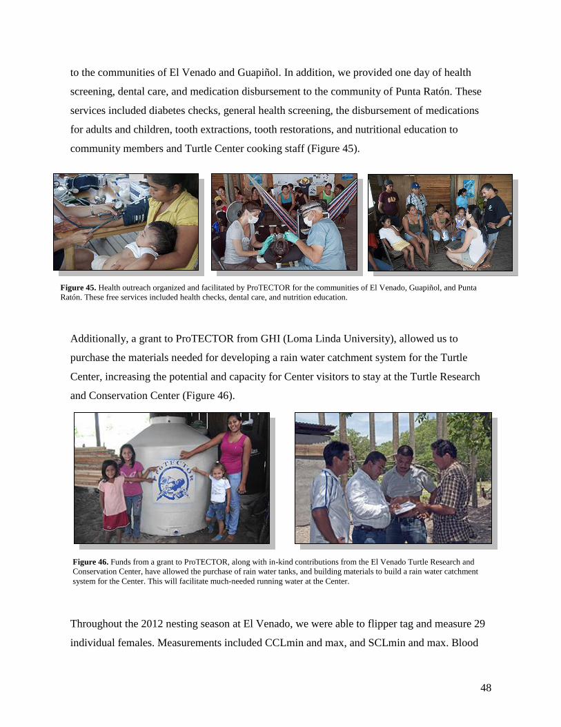
Immediately prior to the veda period, ProTECTOR, working in partnership with the Global
Health Institute (GHI) at Loma Linda University, and the Students for International Mission
Service (SIMS) at Loma Linda University, provided 9 days of health screening and dental care
Figure 44. Noemi Duran and Robyn Reeve (ProTECTOR Intern), collect blood samples from
hatchling L. olivacea after weighing and measuring.
Table 13. Sample numbers of blood and tissue collected at Punta Ratón during the 2011 and 2012
seasons.
48
to the communities of El Venado and Guapiñol. In addition, we provided one day of health
screening, dental care, and medication disbursement to the community of Punta Ratón. These
services included diabetes checks, general health screening, the disbursement of medications
for adults and children, tooth extractions, tooth restorations, and nutritional education to
community members and Turtle Center cooking staff (Figure 45).
Additionally, a grant to ProTECTOR from GHI (Loma Linda University), allowed us to
purchase the materials needed for developing a rain water catchment system for the Turtle
Center, increasing the potential and capacity for Center visitors to stay at the Turtle Research
and Conservation Center (Figure 46).
Throughout the 2012 nesting season at El Venado, we were able to flipper tag and measure 29
individual females. Measurements included CCLmin and max, and SCLmin and max. Blood
Figure 45. Health outreach organized and facilitated by ProTECTOR for the communities of El Venado, Guapiñol, and Punta
Ratón. These free services included health checks, dental care, and nutrition education.
Figure 46. Funds from a grant to ProTECTOR, along with in-kind contributions from the El Venado Turtle Research and
Conservation Center, have allowed the purchase of rain water tanks, and building materials to build a rain water catchment
system for the Center. This will facilitate much-needed running water at the Center.
49
samples were taken from 25 individuals for genetic analysis. These data have not, yet been
compared to data from previous years, but are currently being prepared for comparative
analyses. In addition, we are currently applying for CITES export permits from the
Government of Honduras in order to bring the blood samples back to the U.S. for genetic
analysis.
Satellite tracking of one individual (“Sabine”) did not provide any data. We are unsure if the
tag failed immediately after deployment, or if the turtle was killed, captured, or was entangled
in fishing net and drowned. We did witness illegal fishing activity during the veda just off
shore of the nesting beach. However, satellite telemetry from both “Reina-Christiana” and
“Loanis” did provide important information regarding post-nesting migrational movements of
L. olivacea from the Gulf of Fonseca. Reina-Christiana was released September 9, and
transmissions ceased on November 10, 2012 approximately 20 km southwest of Aposentillo,
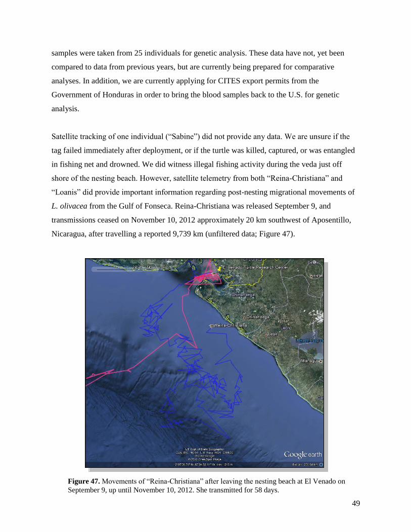
Nicaragua, after travelling a reported 9,739 km (unfiltered data; Figure 47).
Figure 47. Movements of “Reina-Christiana” after leaving the nesting beach at El Venado on
September 9, up until November 10, 2012. She transmitted for 58 days.
50
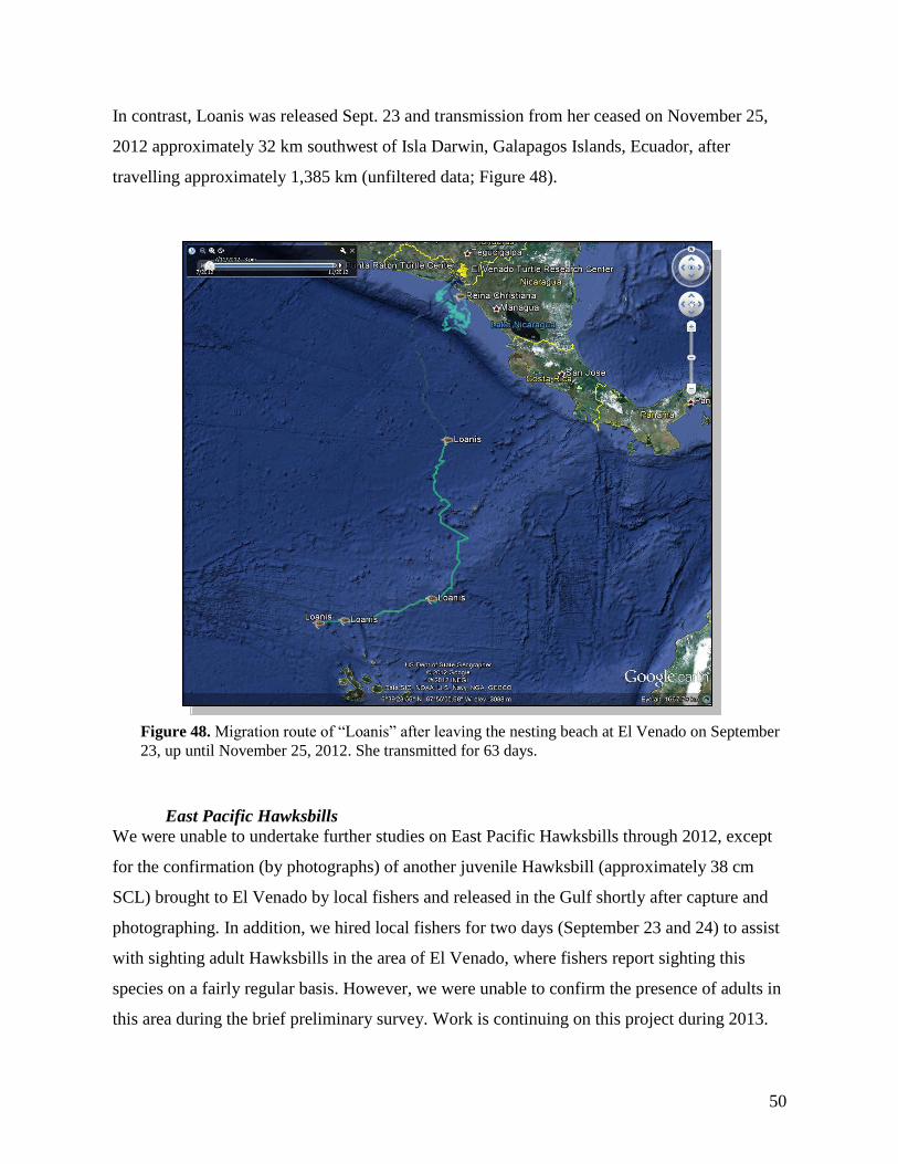
In contrast, Loanis was released Sept. 23 and transmission from her ceased on November 25,
2012 approximately 32 km southwest of Isla Darwin, Galapagos Islands, Ecuador, after
travelling approximately 1,385 km (unfiltered data; Figure 48).
East Pacific Hawksbills
We were unable to undertake further studies on East Pacific Hawksbills through 2012, except
for the confirmation (by photographs) of another juvenile Hawksbill (approximately 38 cm
SCL) brought to El Venado by local fishers and released in the Gulf shortly after capture and
photographing. In addition, we hired local fishers for two days (September 23 and 24) to assist
with sighting adult Hawksbills in the area of El Venado, where fishers report sighting this
species on a fairly regular basis. However, we were unable to confirm the presence of adults in
this area during the brief preliminary survey. Work is continuing on this project during 2013.
Figure 48. Migration route of “Loanis” after leaving the nesting beach at El Venado on September
23, up until November 25, 2012. She transmitted for 63 days.
51
RECOMMENDATIONS Volunteer Research Assistants Program
Whereas there is a continuing need to train young people and those interested in the
conservation of endangered species in Honduras, we recommend the continuing development
of the ProTECTOR Volunteer Program as a way to introduce students and visitors to the areas
of Honduras in which sea turtles play an important role in community economics and eco-
tourism. This will include the training of students from the National Autonomous University of
Honduras (UNAH), and the Polytechnic University of Engineering (UPI), in accordance with
agreements between these institutions and ProTECTOR currently being developed.
Research and Conservation
Whereas there is a great need to ensure that sea turtle conservation efforts throughout
Honduras contribute to population recoveries of sea turtle species in the country, we
recommend that research efforts by ProTECTOR be used and further developed to inform sea
turtle conservation efforts throughout the country. The training of community members,
UNAH, and UPI undergraduate students alongside the ProTECTOR research team and
graduate students from Loma Linda University, will further expand capacity building for
research and increase the production of results that will be used to direct conservation and
environmental education. Furthermore, we propose to work in collaboration with Central
Government entities to incorporate these results into the Honduras National Report provided to
the Inter-American Convention for the Protection and Conservation of Sea Turtles (IAC) each
year, as part of the international reporting requirement of the Convention for Honduras. The
data provided by ProTECTOR is critical to Honduras fulfilling its obligations to the
Convention.
Whereas Honduras does not, at this time, have a national strategic plan for assessing,
managing, or monitoring any sea turtle species in the country’s marine areas, we recommend
that a national assessment of sea turtle populations be undertaken, and that a national strategic
plan be developed, publicized, and initiated, and that continual monitoring of sea turtle
populations be undertaken.
52
Environmental Education and Outreach
Whereas there is great value in utilizing modern technological data collection systems (i.e.
satellite telemetry) as the basis of powerful education outreach efforts, we recommend that
funding support be provided by the Ministry of Environment and/or the Ministry of Education
of the Honduras Government to ensure a standardized, national program is developed and
implemented with respect to sea turtle conservation and environmental education outreach
among coastal communities throughout the country. A program of training and environmental
education may be built on the basis of satellite telemetry data from turtles released from
various locations throughout Honduras. These data can provide powerful lessons in
international resources, international cooperation and diplomacy, the migratory routes of sea
turtles and potential conflicts with commercial fisheries, and a highly interactive mechanism
for involving adults and children.
53
LITERATURE CITED
Dunbar, S. G. 2006. Preliminary Report on Activities Under Interim Permits #
DGPA/005/2006 and DGPA/245/2006 by the Turtle Awareness and Protection Studies
(TAPS) Group under the Protective Turtle Ecology Center for Training, Outreach, and
Research (ProTECTOR). Loma Linda University. Loma Linda. Pp. 11.
Dunbar, S. G. and Berube, M. D. 2008. Hawksbill sea turtle nesting beach reconnaissance
Roatan, Honduras Final Report. United States Fish and Wildlife Services. Washington, D.C.
Pp. 40.
Dunbar, S. G., Breman, J. and Stevenson, L. 2008. Development of the Turtle Awareness and
Protection Studies (TAPS) program on Roatan, Honduras. 28th Annual Symposium on Sea
Turtle Biology and Conservation, Loreto, Baja, California, Mexico. US Department of
Commerce. 22 - 26 January, 2008.
Dunbar, S. G., Randazzo, A., Salinas, L. and Luque, J. 2013. Final Report of the Protective
Turtle Ecology Center for Training, Outreach, and Research, Inc. on Community-Directed
Capacity Building for Hawksbill Conservation and Population Recovery in Caribbean
Honduras. United States Fish and Wildlife Service - Marine Turtle Conservation Fund
(USFWS-MTCF) Loma Linda, CA. Pp. 147.
Dunbar, S. G. and Salinas, L. 2008. Activities of the Protective Turtle Ecology Center for
Training, Outreach, and Research, Inc. (ProTECTOR) on Olive Ridley (Lepidochelys
olivacea) in Punta Raton, Honduras Protective Turtle Ecology Center for Training,
Outreach, and Research, Inc. (ProTECTOR). Loma Linda. Pp. 30.
Dunbar, S. G., Salinas, L. and Berube, M. D. 2009. Activities of the Turtle Awareness and
Protection Studies (TAPS) Program under the Protective Turtle Ecology Center for
Training, Outreach, and Research, Inc. (ProTECTOR) in Roatan, Honduras; Annual Report
of the 2007 - 2008 Season. Protective Turtle Ecology Center for Training, Outreach, and
Research, Inc. (ProTECTOR). Loma Linda. Pp. 60.
Dunbar, S. G., Salinas, L. and Castellanos, S. 2010. Activities of the Protective Turtle Ecology
Center for Training, Outreach and Research, Inc. (ProTECTOR) in Punta Ratón, Honduras,
annual report of the 2008-2009 season. ProTECTOR. Tegucigalpa. Pp. 43.
Dunbar, S. G., Salinas, L. and Castellanos, S. 2011. Activities of the Protective Turtle Ecology
Center for Training, Outreach and Research, Inc. (ProTECTOR) in the Golf of Fonseca,
Honduras, annual report of the 2009-2010 season. ProTECTOR. Tegucigalpa. Pp. 57.
Dunbar, S. G., Salinas, L. and Castellanos, S. 2012. Report of the Gulf of Fonseca Hawksbill
Project in Pacific Honduras; Year End Report from 2011. Protective Turtle Ecology Center
for Training, Outreach, and Research, Inc. (ProTECTOR). Loma Linda. Pp. 30.
Mossa, J. 1998. The bipolar line level; a simple method of topographic surveying. Journal of
Sedimentary Research 68: 1048-1050.

54
© ProTECTOR, 2013. This report may not be used for reproduction or reporting without permission from ProTECTOR.