Embed Size (px)
Citation preview

1
MINNESOTA
Address Point Data Standard Version 1.1 – Published 4/13/2018 Approved by the Minnesota Geospatial Advisory Council on 3/28/2018

2
Table of Contents
Introduction ................................................................................................................................................................... 3
Purpose of this Standard ........................................................................................................................................... 3
Applicability ............................................................................................................................................................... 3
Sources of this Standard ............................................................................................................................................ 3
Compliance Notes .......................................................................................................................................................... 4
Inclusion ..................................................................................................................................................................... 4
Mixed Case ................................................................................................................................................................ 4
Abbreviations ............................................................................................................................................................. 4
Domains ..................................................................................................................................................................... 5
Database Summary Table .............................................................................................................................................. 6
Data Element Details ..................................................................................................................................................... 8
1. Identification Elements .......................................................................................................................................... 8
2. Address Elements .................................................................................................................................................. 9
3. Area Elements ...................................................................................................................................................... 13
4. Functional Elements ............................................................................................................................................ 15
5. GeoLocation Elements ......................................................................................................................................... 17
6. 911 Elements ....................................................................................................................................................... 18
7. Management Elements ........................................................................................................................................ 19
Appendix A: MN Address Point Data Standard Schema V1.1 ...................................................................................... 21
Appendix B: XML Formatting Template ....................................................................................................................... 21

3
Introduction Address points are a core geospatial infrastructure dataset for Minnesota. They are used for many types of analysis, mapping and application development in areas such as emergency response, health and human services, planning and zoning, permit tracking, and more. An address point dataset envisioned by this standard includes a point location, address attributes, and other related attributes for each official address as defined by the official address authority. In Minnesota, addresses originate primarily from the work of city and county governments. City councils have legal authority to assign addresses (Minnesota Statutes §412.221, Subd. 18) and in practice, that action is carried out on behalf of a city council by different city departments such as public works or planning or zoning. County governments assign addresses in most townships and unorganized areas of the state. Some townships are also official address authorities, and in some cases, other entities may be seated the authority to create addresses. E.g. military bases, University of MN, MSP Airport.
Purpose of this Standard The purpose of this standard is to provide a single, commonly accepted set of attribute specifications (field name, type, length, and order) for transferring and aggregating address point data in Minnesota for a wide variety of purposes. It is primarily intended to be used when data are being transferred in any direction between cities, counties, state agencies, and external customers. Use of the standard will improve the ability to share data resources by reducing incompatibilities when acquiring, processing and disseminating address point data.
Applicability Data producers may have unique methods, definitions, and criteria for capture and storage of address point data that satisfy their own business requirements. This standard seeks to establish attribute specifications for data exchange purposes. It does not attempt to define internal data capture or storage specifications for data producers, though some may find benefit in storing data in this format. Organizations within Minnesota are encouraged to adopt this standard for purposes of data exchange.
Sources of this Standard The data specifications for the Minnesota Address Points Data Standard are derived primarily from the Content portion of the United States Thoroughfare, Landmark, and Postal Address Data Standard, which has been approved by the Federal Geographic Data Committee (FGDC) and will be referenced in this document as the “FGDC standard”. The National Emergency Number Association (NENA) and U.S. Postal Service (USPS) were partners in the development of the FGDC standard. The Minnesota standard also draws from the NENA geospatial data standards that are in draft format at the time of this version of the MN standard. Some additional data elements have been added to the MN standard to satisfy data needs of the Minnesota geospatial community. This MN standard references the FGDC element numbers from the 2011 approved United States Thoroughfare, Landmark, and Postal Address Data Standard. A 2015-2016 review process of the FGDC standard included a proposed revised standard with some changes to element numbers. Because the proposed changed element numbers have not been approved by the FGDC at the time of this version of the MN standard, they are not used. FGDC references are included in the Database Fields table as well as noted in italics within the element descriptions.

4
Compliance Notes It is up to each organization to choose whether to comply with this standard for purposes of data exchange. An address points dataset that complies with this standard will consist of geospatial points with all attribute fields included in this standard. It will also comply with the inclusion, mixed case, abbreviation and domain specifications of this standard.
Inclusion Inclusion is a term for the status of a specific attribute being present in the standard. Four types of inclusion are referenced for the attributes of this standard: Mandatory, Conditional - If Applicable, Conditional - If Available, and Optional.
Mandatory Field must be populated for each record to be compliant with the standard. Null values are not allowed. Example: COUNTY_PIN is a Mandatory field in this standard. If COUNTY_PIN values are missing, the database does not comply with the Parcel Data Transfer Standard.
Conditional - If Applicable (mandatory if applicable) Each field must be populated with a non-null value for each record that is applicable to the feature. Example 1: Lot, Block and Plat values must be populated for all platted properties; however, they will be null for non-platted properties. Example 2: An address on “West Seventh Street” has a Pre Directional of “West”. All addresses on this street are required to have the Pre Directional field populated, but not the Post Directional field. The Pre Directional field applies to this feature.
Conditional - If Available (mandatory if available) Field must be populated if the data exists in the data provider’s database.
Example: The Effective Data indicates the earliest date the address was known to exist. It must be populated for new addresses and where the data exist to populate it for existing addresses. However, many cities and counties do not have data indicating when older addresses first came into existence. In such cases, the field is not required to be populated.
Optional Field is not required to be populated.
Mixed Case Per the FGDC standard, all field values in this standard will use a mixed case format. Some end users may want an all-caps format for a specific purpose. Data may be converted to all caps by end users if desired. It is more difficult to automatically convert all caps back to mixed case. Note: The NENA standard also uses mixed case for many of its data registries (e.g. street name pre and post types).
Abbreviations Per the FGDC standard, all field values in this standard mustshould be spelled out unless specifically defined otherwise in the field description. This is done to remove ambiguity. The FGDC standard provides the example of “N W Jones Tr.” Is it “Northwest Jones Tr,” “Noble Wimberly Jones Tr,” or “North William Jones Tr”? Does Tr stand for Terrace, Trail, or Trace? This is also done because standard lists of abbreviations are bound to be incomplete. A few examples of street types missing from the USPS list include: Alcove, Close, Connector, Downs, Exchange, and Promenade. Note: The NENA standard does not use abbreviations for many of its data registries (e.g. street name pre and post types).

5
Domains Several domain tables accompany this standard in a schema spreadsheet available at this link. To comply with this standard, an address points dataset must adhere to these domains but does not need to include the domain tables with the data. If a local value exists that is not included in a domain (e.g. a street type), it may be submitted to the MN Geospatial Advisory Council, Standards Committee to be included in the domain. Domains will be updated on a periodic basis, as needed. The date of the most recent change to each domain table will be included in the main table of the schema spreadsheet.

6
Database Summary Table Element Number
Element Name Database Field Name
Field Type
Field Width
Inclusion Domain FGDC Element
1. Identification Elements
1.1 Address Unique Identifier ADD_ID Text 36 Mandatory 2.3.1.1
1.2 Local Address Unique Identifier ADD_ID_LOC Text 50 If Applicable None
2. Address Elements
2.1 Address Number Prefix ANUMBERPRE Text 15 If Applicable 2.2.1.1
2.2 Address Number ANUMBER Integer Long Integer
Mandatory 2.2.1.2
2.3 Address Number Suffix ANUMBERSUF Text 15 If Applicable 2.2.1.3
2.4 Street Name Pre Modifier ST_PRE_MOD Text 15 If Applicable 2.2.2.1
2.5 Street Name Pre Directional ST_PRE_DIR Text 9 If Applicable Street Directional 2.2.2.2
2.6 Street Name Pre Type ST_PRE_TYP Text 35 If Applicable Street Pre Type 2.2.2.3
2.7 Street Name Pre Separator ST_PRE_SEP Text 20 If Applicable 2.2.2.4
2.8 Street Name ST_NAME Text 60 Mandatory 2.2.2.5
2.9 Street Name Post Type ST_POS_TYP Text 15 If Applicable Street Post Type 2.2.2.6
2.10 Street Name Post Directional ST_POS_DIR Text 9 If Applicable Street Directional 2.2.2.7
2.11 Street Name Post Modifier ST_POS_MOD Text 15 If Applicable 2.2.2.8
2.12 Subaddress Type 1 SUB_TYPE1 Text 12 If Applicable Subaddress Type 2.2.4.1
2.13 Subaddress Identifier Type 1 SUB_ID1 Text 30 If Applicable 2.2.4.2
2.14 Subaddress Type 2 SUB_TYPE2 Text 12 If Applicable Subaddress Type 2.2.4.1
2.15 Subaddress Identifier Type 2 SUB_ID2 Text 30 If Applicable 2.2.4.2
2.16 ZIP Code ZIP Text 5 Mandatory 2.2.6.3 **
2.17 ZIP Plus 4 ZIP4 Text 4 Optional 2.2.6.4
3. Area Elements
3.1 CTU Name CTU_NAME Text 100 Mandatory CTU Name 2.2.6.1, 2.3.8.4
3.2 CTU Code CTU_ID_TXT Text 8 Mandatory CTU ID Text 2.3.8.5
3.3 Postal Community Name POSTCOMM Text 40 Optional 2.2.6.1, 2.3.8.4
3.4 County Code CO_CODE Text 5 Mandatory County Code 2.3.8.6
3.5 County Name CO_NAME Text 40 Mandatory County Name 2.2.6.1, 2.3.8.4
3.6 State Code STATE_CODE Text 2 Mandatory State Code 2.2.6.3**
4. Functional Elements
4.1 Location Description LOC_DESC Text 254 Optional 2.3.7.8
4.2 Complete Landmark Name LANDMARK Text 150 Optional 2.2.5.2
4.3 Residence RESIDENCE Text 10 Optional Yes No Unknown None
4.4 Mailable Address MAILABLE Text 10 Optional Yes No Unknown 2.3.7.9
4.5 Parcel Unique Identifier STATE_PIN Text 28 Optional 2.3.3.1
4.6 Placement Location PLACE_LOC Text 2 Optional Placement Location
None
4.7 Centerline Geocodable CEN_GEO Text 10 Mandatory Yes No Unknown None
4.8 Unique Without Subaddresses UNI_WO_SUB Text 10 Optional Yes No Unknown None
5. GeoLocation Elements
5.1 Longitude LONGITUDE Real double Mandatory 2.3.2.3
5.2 Latitude LATITUDE Real double Mandatory 2.3.2.4
5.3 US National Grid Code USNG_CODE Text 15 Optional 2.3.2.5
6. 911 Elements
6.1 911 GIS Point-of-Contact GIS911POC Text 75 Mandatory 911 GIS POC None
6.2 Emergency Service Number ESN Text 5 Mandatory None
6.3 PSAP Code PSAP_CODE Text 5 Mandatory PSAP Code None
6.4 MSAG Community Name MSAG_C Text 30 Mandatory MSAG Community
None
6.5 911 Validation Error VERROR_911 Text 10 Optional Yes No Unknown None

7
7. Management Elements
7.1 Lifecycle Status STATUS Text 10 Optional Lifecycle Status 2.3.7.3
7.2 Effective Date EFF_DATE Date default If Available 2.3.9.1
7.3 Retired Date RET_DATE Date default If Applicable 2.3.9.2
7.4 Source of Data SOURCE Text 75 Optional 2.3.9.4
7.5 Address Authority AAUTHORITY Text 40 Mandatory 2.3.1.2
7.6 Editing Organization EDIT_ORG Text 40 Optional None
7.7 Edited Date EDITED_DT Date default Mandatory None
7.8 Comments COMMENTS Text 254 Optional None
* See Appendix B for an XML formatting template. **Current version of FGDC standard uses same number for both elements

8
Data Element Details
1. Identification Elements
1.1 Address Unique Identifier
Database Name ADD_ID
Data Type Text Inclusion Mandatory
Width 36 Domain
Examples
Description 2.3.1.1 Address ID: The unique identifier assigned to an address. Each address record must have a unique ID. This will distinguish it from any other record in the local, state or national database. It will also allow other datasets to be related to the address database (e.g. landmark names, contact phone number, existence of lifesaving equipment/defibrillator, existence of hazardous waste, etc.).
1.2 Local Address Unique Identifier
Database Name ADD_ID_LOC
Data Type Text Inclusion
Width 50 Domain
Examples
Description Each address authority may have an internal Unique_ID and formatting convention which can be included within this field. See below for further explanation.
Address Unique Identifier (National) vs. Local Address Unique Identifier Each unique official address authority will likely maintain a unique identifier for each address point record. The formatting and structure of that unique identifier is completely at the discretion of the local address authority as long as the ID can be converted to a 50-character text field in this standard and maintain its uniqueness. Because it is desirable to aggregate address point data at a state or possibly even national level, it is necessary to have a nationally unique address ID in this standard. If the local address authority or partnering county does not already have a procedure to create a nationally unique ID, this may be accomplished by appending the GNIS unique ID for the city or township (in the 8-character text with leading zeros Census format) and a dash to the beginning of the local unique ID. It must be stressed that the GNIS code is meaningless once placed in the unique ID. Permanence Recommendations The following are recommended, but are not required:
Unique IDs should not be reused if they are retired.
Unique IDs should not be changed unless there is a change to the geographic feature (occupiable unit) itself. For example, if a street name changes, the street name field of the address record should change, but not the unique ID. If the parcel in which the unit resides is split and the parcel receives a new parcel ID, the unique ID of the address point should not change. If an annexation causes an address point to change jurisdiction from one city or township to another, it is desirable that the unique ID remain the same. It is realized, however, that this may place a burden on local address authorities, especially in the last example. Each address authority will need to determine for itself to what degree it should adhere to these recommendations.

9
2. Address Elements
2.1 Address Number Prefix
Database Name ANUMBERPRE
Data Type Text Inclusion Conditional
Width 15 Domain
Examples 61-43 Springfield Lane
Description FGDC Element 2.2.1.1: The portion of the complete address number which precedes the address number itself. Note: for an address range separated by a dash, the first number and dash will go in the prefix. This is consistent with the NENA address standard, but differs from the FGDC standard.
2.2 Address Number
Database Name ANUMBER
Data Type Long Integer Inclusion If Applicable
Width 10 Domain
Examples 1234 Main Street
Description FGDC Element 2.2.1.2: The numeric identifier for a land parcel, house, building or other location along a thoroughfare or within a community.
2.3 Address Number Suffix
Database Name ANUMBERSUF
Data Type Text Inclusion If Applicable
Width 15 Domain
Examples 123 1/2 Main Street, 456 B Wilson Street
Description FGDC Element 2.2.1.3: The portion of the complete address number which follows the address number itself.
2.4 Street Name Pre Modifier
Database Name ST_PRE_MOD
Data Type Text Inclusion If Applicable
Width 15 Domain
Examples Old North First Street, Alternate North Avenue B
Description FGDC Element 2.2.2.1: A word or phrase that 1. precedes and modifies the Street Name, but is separated from it by a Street Name Pre Type or a Street Name Pre Directional or both, or 2. Is placed outside the Street Name so that the Street Name can be used in creating a sorted list of street names.
2.5 Street Name Pre Directional
Database Name ST_PRE_DIR
Data Type Text Inclusion If Applicable
Width 9 Domain Street Directional
Examples North Main Street
Description FGDC Element 2.2.2.2: A word preceding the Street Name that indicates the direction or position of the thoroughfare relative to an arbitrary starting point or line, or the sector where it is located. Note: Do not use words that are part of the street name as a directional. For example, in North Shore Drive, “North” would be part of the street name if it is a drive named for the North Shore as opposed to the northern section of Shore Drive.

10
2.6 Street Name Pre Type
Database Name ST_PRE_TYP
Data Type Text Inclusion If Applicable
Width 35 Domain Street Pre Type
Examples County Road 14, Interstate 94, Avenue of the Stars
Description FGDC Element 2.2.2.3: A word or phrase that precedes the Street Name and identifies a type of thoroughfare in a complete street name. NOTE: Like the FGDC standard, this standard does not allow abbreviations for this element.
2.7 Street Name Pre Separator
Database Name ST_PRE_SEP
Data Type Text Inclusion If Applicable
Width 20 Domain
Examples Avenue of the Stars
Description If a Complete Street Name includes a prepositional phrase between a Street Name Pre Type and a Street Name, the prepositional phrase is treated as a separator. Note: This standard uses a separator element consistent with the NENA address standard. (This is only partly consistent with the FGDC separator element which attempts to include three different types of separators in one element.)
2.8 Street Name
Database Name ST_NAME
Data Type Text Inclusion If Applicable
Width 60 Domain
Examples Central Street Southwest, County Road 7
Description FGDC Element 2.2.2.5: The portion of the complete street name that identifies the particular thoroughfare. For numbered streets (e.g. Third Street, 3rd Street), use the format and spelling as defined by each official local address authority. For street name formats like 2nd, 3rd and 4th, use lower case letters. NOTE: Like the FGDC standard, this standard requires mixed case for this element.
2.9 Street Name Post Type
Database Name ST_POS_TYP
Data Type Text Inclusion If Applicable
Width 15 Domain Street Post Type
Examples 1234 Central Street Southwest
Description FGDC Element 2.2.2.6: A word or phrase that follows the street name and identifies a type of thoroughfare. NOTE: Like the FGDC standard, this standard does not allow abbreviations for this element.

11
2.10 Street Name Post Directional
Database Name ST_POS_DIR
Data Type Text Inclusion If Applicable
Width 9 Domain Street Directional
Examples 1234 Cherry Street North
Description FGDC Element 2.2.2.7: A word following the Street Name that indicates the direction or position of the thoroughfare relative to an arbitrary starting point or line, or the sector where it is located. NOTE: Like the FGDC standard, this standard does not allow abbreviations for this element.
2.11 Street Name Post Modifier
Database Name ST_POS_MOD
Data Type Text Inclusion If Applicable
Width 15 Domain
Examples 1230 Central Avenue Extended
Description FGDC Element 2.2.2.8: A word or phrase that follows and modifies the Street Name, but is separated from it by a Street Name Post Type or a Street Name Post Directional or both.
2.12 Subaddress Type 1
Database Name SUB_TYPE1
Data Type Text Inclusion If Applicable
Width 12 Domain Subaddress Type
Examples Apartment B3, Building 6, North Tower, O’Shaughnessy Science Hall, Floor 2, Mezzanine Level, Suite 10
Description FGDC Element 2.2.4.1: The type of subaddress to which the associated Subaddress Identifier applies.
2.13 Subaddress Identifier 1
Database Name SUB_ID1
Data Type Text Inclusion If Applicable
Width 30 Domain
Examples Apartment B3, Building 6, North Tower, O’Shaughnessy Science Hall, Floor 2, Mezzanine Level, Suite 10
Description FGDC Element 2.2.4.2: The letters, numbers, words or combination thereof used to distinguish different subaddresses of the same type when several occur in the same feature.
2.14 Subaddress Type 2
Database Name SUB_TYPE2
Data Type Text Inclusion If Applicable
Width 12 Domain Subaddress Type
Examples Apartment B3, Building 6, North Tower, O’Shaughnessy Science Hall, Floor 2, Mezzanine Level, Suite 10
Description FGDC Element 2.2.4.1: The type of subaddress to which the associated Subaddress Identifier applies.

12
2.15 Subaddress Identifier 2
Database Name SUB_ID2
Data Type Text Inclusion If Applicable
Width 30 Domain
Examples Apartment B3, Building 6, North Tower, O’Shaughnessy Science Hall, Floor 2, Mezzanine Level, Suite 10
Description FGDC Element 2.2.4.2: The letters, numbers, words or combination thereof used to distinguish different subaddresses of the same type when several occur in the same feature.
About Subaddress Elements
Within the FGDC standard, the subaddress type and subaddress identifier elements are formatted as repeating pairs because some addresses have multiple subaddress types. This is easy to do in an XML schema, but in a database, requires a related table. Because many GIS practitioners have implementations that use flat files without related tables (e.g. shape files), this standard uses multiple sets of subaddress elements. Any additional subaddress information that cannot fit into these elements should be included in the Location Description field. The NENA standard uses a different method to encode subaddress information, which combines the type and identifier into a single field and requires putting all types into one of five categories which are separate fields (building, floor, unit, room and seat). Within NENA, anything that does not fit into one of those categories goes into the Location Description field (e.g. East Wing) The provided domain includes subaddress types, examples of IDs for each type and a field to map each type to one of the five NENA categories where applicable. Not all types fit a NENA category.
2.16 ZIP Code
Database Name ZIP
Data Type Text Inclusion If Applicable
Width 5 Domain
Examples 56301
Description FGDC Element 2.2.6.4: A system of 5-digit codes that identifies the individual Post Office or metropolitan area delivery station associated with an address.
2.17 ZIP Plus 4
Database Name ZIP4
Data Type Text Inclusion Optional
Width 4 Domain
Examples 3846
Description FGDC Element 2.2.6.5: A 4-digit extension of the5-digit ZIP Code (preceded by a hyphen) that, in conjunction with the ZIP code, identifies a range of the USPS delivery addresses.

13
3. Area Elements Note: The FGDC standard requires two elements (2.2.6.1 Place Name and 2.3.8.4 Place Name Type) as repeating pairs to indicate various types of place names (county name, city name, USPS community name). This works well in an XML format, but does not work well in a flat file format. Stakeholders in the Minnesota geospatial community have identified a need to more specifically identify the municipal jurisdiction, the US postal community and the county in which an address point exists. Thus, this standard includes separate data elements for each.
3.1 CTU Name
Database Name CTU_NAME
Data Type Text Inclusion Mandatory
Width 100 Domain CTU Name
Examples Bloomington, Lake View Township, Rushford
Description The name of the city, township, or unorganized territory (CTU) n which the address point is physically located. In many places, this will be different than the city name used by the U.S. Postal Service. Note: Minnesota has a CTU Identifier Codes standard. Note: This standard uses CTU names without abbreviations (e.g. Saint instead of St.) A city may change the standard name to an abbreviated format if that is the city’s official spelling.
3.2 CTU Code
Database Name CTU_ID_TXT
Data Type Text Inclusion Mandatory
Width 8 Domain CTU ID Text
Examples 02394789, 00664194
Description The official Federal Geographic Names Information Systems unique identifier code for the city, township or unorganized territory in which the address point is physically located. There are two Federal formats: 1. The U.S. Census text format with leading zeros is required in this standard. (e.g. 02394789, 00664194) 2. The USGS integer format is NOT compliant with this Minnesota standard. (e.g. 2394789, 664194) Note: Minnesota has a CTU Identifier Codes standard. Note: The CTU ID Text domain has more records than the CTU Name domain because Minnesota has multiple townships and unorganized territories with the same name. Each has a unique CTU ID.

14
3.3 Postal Community Name
Database Name POSTCOMM
Data Type Text Inclusion Optional
Width 40 Domain
Examples Saint Cloud
Description A city name recognized by the USPS as valid for the ZIP Code of the address point. The USPS recognizes one or more city names as being valid for each ZIP Code. It also designates one of the city names as the default for the ZIP Code and asks for it to be used “whenever possible”. In many places this will be different than the name of the city or township in which the address is physically located. For example, addresses within the cities of Hermantown and Proctor use the ZIP Code of 55810, but the USPS default city name for this ZIP Code is Duluth. USPS recognized and default city names for a given zip code can be found using this USPS form. A lookup table accompanies this standard that provides the default USPS city name for each ZIP Code.
3.4 County Code
Database Name CO_CODE
Data Type Text Inclusion Mandatory
Width 5 Domain County Code
Examples 27001 (Aitkin County), 27003 (Anoka County)
Description The combination of the two-character state numeric code and the three-character county code in which the address point resides. Note: Both state and county codes are national and state approved standards. Minnesota county code standard. Minnesota state code standard.
3.5 County Name
Database Name CO_NAME
Data Type Text Inclusion Mandatory
Width 40 Domain County Name
Examples Roseau, Winona
Description The name of the county in which the address point is physically located
3.6 State Code
Database Name STATE_CODE
Data Type Text Inclusion Mandatory
Width 2 Domain State Code
Examples MN
Description FGDC Element 2.2.6.3: The two-character state code for mailing purposes. This will always be “MN” for Minnesota and in compliance with the Minnesota state code standard.
15
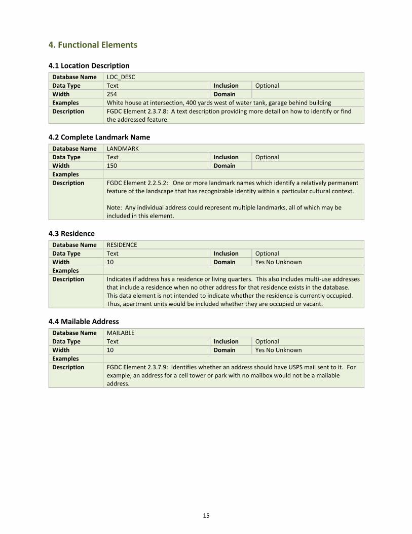
4. Functional Elements
4.1 Location Description
Database Name LOC_DESC
Data Type Text Inclusion Optional
Width 254 Domain
Examples White house at intersection, 400 yards west of water tank, garage behind building
Description FGDC Element 2.3.7.8: A text description providing more detail on how to identify or find the addressed feature.
4.2 Complete Landmark Name
Database Name LANDMARK
Data Type Text Inclusion Optional
Width 150 Domain
Examples
Description FGDC Element 2.2.5.2: One or more landmark names which identify a relatively permanent feature of the landscape that has recognizable identity within a particular cultural context. Note: Any individual address could represent multiple landmarks, all of which may be included in this element.
4.3 Residence
Database Name RESIDENCE
Data Type Text Inclusion Optional
Width 10 Domain Yes No Unknown
Examples
Description Indicates if address has a residence or living quarters. This also includes multi-use addresses that include a residence when no other address for that residence exists in the database. This data element is not intended to indicate whether the residence is currently occupied. Thus, apartment units would be included whether they are occupied or vacant.
4.4 Mailable Address
Database Name MAILABLE
Data Type Text Inclusion Optional
Width 10 Domain Yes No Unknown
Examples
Description FGDC Element 2.3.7.9: Identifies whether an address should have USPS mail sent to it. For example, an address for a cell tower or park with no mailbox would not be a mailable address.

16
4.5 State
Database Name STATE_PIN
Data Type Text Inclusion Optional
Width 28 Domain
Examples 27001-29-0-0559-2 (example from Aitkin County) 27053-12-029-24-32-0243 (example from Hennepin County)
Description FGDC Element 2.3.3.1: The primary permanent identifier, as defined by the address parcel identifier source, for a parcel that includes the land or feature identified by an address. Note: The county code (which includes the state code of “27”) and a dash must be added to the beginning of the PIN string to accommodate cross county and state boundary uniqueness.
4.6 Placement Location
Database Name PLACE_LOC
Data Type Text Inclusion Optional
Width 2 Domain Placement Location
Examples
Description A code that indicates the location used for placing the point. The NENA address data standard includes a similar data element. Because many state geospatial practitioners require more detail with this element, this standard has created its own element with a crosswalk to the NENA values. Note: The Placement Location domain table includes a crosswalk to the related NENA Placement Method values
4.7 Centerline Geocodable
Database Name CEN_GEO
Data Type Text Inclusion Mandatory
Width 10 Domain Yes No Unknown
Examples
Description Used to identify official addresses that have been validated by the addressing authority and confirmed to not be included in the corresponding road centerline data. Such addresses would have a “No” value in this element. This is very useful to know for 9-1-1 dispatching purposes. Examples of such addresses include official addresses on islands without named roads and historical “grandfathered” addresses.
4.8 Unique Without Subaddresses
Database Name UNI_WO_SUB
Data Type Text Inclusion Optional
Width 10 Domain Yes No Unknown
Examples
Description There are uses for address point data where subaddress information is not desirable (e.g. some computer aided dispatch systems and geocoding processes). Ignoring or deleting subaddress information can result in many duplicate address records. This data element is used to flag one record for each unique address when subaddress information is not used. Example: An address point dataset has 20 records for an apartment building with 20 units. Each record includes the apartment number in the subaddress fields. This field would be “Yes” for 1 of the records and “No” for the other 19 records. All other records in the dataset that do not have subaddresses would also be set to “Yes” in this field.

17
5. GeoLocation Elements
5.1 Longitude
Database Name LONGITUDE
Data Type Real Inclusion Mandatory
Width Double Domain
Examples 84.29049105
Description FGDC Element 2.3.2.3: The longitude of the address location, in decimal degrees, WGS84 datum.
5.2 Latitude
Database Name LATITUDE
Data Type Real Inclusion Mandatory
Width Double Domain
Examples 33.77603207
Description FGDC Element 2.3.2.4 Address Latitude: The latitude of the address location, in decimal degrees, WGS84 datum.
5.3 US National Grid Code
Database Name USNG_CODE
Data Type Inclusion
Width Domain
Examples 18SUJ2348306479 (Locates a point with a precision of 1 meter)
Description FGDC Element 2.3.2.5: The code for the US National Grid cell within which the address point exists. There should be no spaces in the code. Note: This element may be populated by a data aggregating organization (e.g. a county).

18
6. 911 Elements
6.1 911 GIS Point-of-Contact
Database Name GIS911POC
Data Type Text Inclusion Mandatory
Width 75 Domain 911 GIS POC
Examples
Description The entity responsible for submitting Geographic Information System (GIS) data to the State of Minnesota to be used for NG9-1-1 service for a specified area. This is typically a county GIS department or Public Safety Answering Point (PSAP). In its County 9-1-1 Plan, which is submitted to the Minnesota Department of Public Safety, a county must specify the 9-1-1 GIS Authority/Authorities for each of the required NG9-1-1 datasets that encompass the county’s geographic area. This element may use all uppercase value.
6.2 Emergency Service Number
Database Name ESN
Data Type Text Inclusion Mandatory
Width 5 Domain
Examples
Description A 3 to 5-character numeric code that identifies a single ESZ. There should be no leading zeros in the code. ESNs are included in the MSAG for a given PSAP and represent unique combinations of individual fire, law, emergency medical response, and other emergency agencies.
6.3 PSAP Code
Database Name PSAP_CODE
Data Type Text Inclusion Mandatory
Width 5 Domain PSAP Code
Examples ANOK, CASS, OLMS
Description The 4 to 5-character Public Safety Answering Point identifier code from the ELT/ALI display for the given address point feature.
6.4 MSAG Community Name
Database Name MSAG_C
Data Type Text Inclusion Mandatory
Width 30 Domain MSAG Community
Examples
Description The Community name associated with an address as given in the Master Street Address Guide (MSAG) used for 9-1-1 purposes. This may or may not be the same as the Municipal Jurisdiction Name or the Postal Community Name. This element may use all uppercase value.
6.5 911 Validation Error
Database Name VERROR_911
Data Type Text Inclusion Optional
Width 10 Domain Yes No Unknown
Examples
Description This attribute is used as a flag to indicate a known 911 validation error that has yet to be resolved. If ‘Yes” is chosen, then an explanation is required in the comments field. ‘No’ indicates there are no 911 validation errors for this feature. ‘Unknown’ indicates the feature has not been tested for 911 validation errors. Nulls are allowed for this attribute

19
7. Management Elements
7.1 Lifecycle Status
Database Name STATUS
Data Type Text Inclusion Optional
Width 10 Domain Lifecycle Status
Examples Active, Retired, Proposed
Description FGDC Element 2.3.7.3: The lifecycle status of the address
7.2 Effective Date
Database Name EFF_DATE
Data Type Date Inclusion If Available
Width Default Domain
Examples
Description FGDC Element 2.3.9.1: The earliest date on which the address is known to exist. Note that this is a conditional – If Available element. It must be populated for new addresses and where the data exist to populate it for existing addresses. However, many cities and counties do not have data indicating when older addresses first came into existence. In such cases, the field is not required to be populated.
7.3 Retired Date
Database Name RET_DATE
Data Type Date Inclusion Conditional
Width Default Domain
Examples
Description FGDC Element 2.3.9.2: The date on which the address was retired from active status.
7.4 Source of Data
Database Name SOURCE
Data Type Text Inclusion Optional
Width 75 Domain
Examples
Description FGDC Element 2.3.9.4: Source from whom the data provider obtained the address, or with whom the data provider validated the address. Note: This field could be used to indicate the department within a city that supplied the address (e.g. Planning and Zoning, Fire Dept., Public Works or a provider of addresses on private streets)
7.5 Address Authority
Database Name AAUTHORITY
Data Type Text Inclusion Mandatory
Width 40 Domain
Examples
Description FGDC Element 2.3.1.2: The name of the authority (e.g., municipality name, county name) that created or has jurisdiction over the creation, alteration, or retirement of an address. Note: Entities other than cities and counties might be possible here (e.g. U of M, 3M (on their campus), Mille Lacs Band of Ojibwe, US Forest Service).

20
7.6 Editing Organization
Database Name EDIT_ORG
Data Type Text Inclusion Optional
Width 40 Domain
Examples
Description This is intended to indicate the organization that made the last substantial change to the data record including point location. This is not intended to be used to identify an aggregating organization that ran a batch process to populate fields derived from existing data (e.g. populating the US National Grid Code or the County Name or Code).
7.7 Edited Date
Database Name EDITED_DT
Data Type Date Inclusion Mandatory
Width Default Domain
Examples
Description This is intended to indicate the date of the initial entry or last substantial change to the data record including point location. This is not intended to be used to identify the date a batch process was used to populate fields derived from existing data (e.g. populating the US National Grid Code or the County Name or Code).
7.8 Comments
Database Name COMMENTS
Data Type Text Inclusion Optional
Width 254 Domain
Examples
Description A field for free form comments as deemed useful by the address authority.

21
Appendix A: MN Address Point Data Standard Schema V1.1 This appendix is a schema spreadsheet available at this link. It include a tab for each domain and lookup table referenced by this standard. It also includes a master tab showing all the data elements in the standard, with field name, type, width and other important information about each data element.
Appendix B: XML Formatting Template This is a template to guide the formatting of data into an XML transfer file
Element Name Database Field Name
XML Tag from FGDC Standard or “MN” Specific Tag
Address Unique Identifier ADD_ID <AddressID>
Local Address Unique Identifier ADD_ID_LOC <MNAddressIDLocal>
Address Number Prefix ANUMBERPRE <AddressNumberPrefix>
Address Number ANUMBER <AddressNumber>
Address Number Suffix ANUMBERSUF <AddressNumberSuffix>
Street Name Pre Modifier ST_PRE_MOD <StreetNamePreModifier>
Street Name Pre Directional ST_PRE_DIR <StreetNamePreDirectional>
Street Name Pre Type ST_PRE_TYP <StreetNamePreType>
Street Name Pre Separator ST_PRE_SEP <MNStreetNamePreSeparator
Street Name ST_NAME <StreetName>
Street Name Post Type ST_POS_TYP <StreetNamePostType>
Street Name Post Directional ST_POS_DIR <StreetNamePostDirectional>
Street Name Post Modifier ST_POS_MOD <StreetNamePostModifier>
Subaddress Type 1 SUB_TYPE1 <SubaddressType>
Subaddress Identifier 1 SUB_ID1 <SubaddressIdentifier>
Subaddress Type 2 SUB_TYPE2 <SubaddressType>
Subaddress Identifier 2 SUB_ID2 <SubaddressIdentifier>
ZIP Code ZIP <ZIPCode>
ZIP Plus 4 ZIP4 <ZIPPlus4>
CTU Name CTU_NAME *<PlaceName>
CTU Code CTU_ID_TXT *GNISFeatureID
Postal Community Name POSTCOMM *<PlaceName>
County Code CO_CODE <MNCountyCode>
County Name CO_NAME *<PlaceName>
State Code STATE_CODE <StateName>
Location Description LOC_DESC <LocationDescription>
CompleteLandmark Name LANDMARK <LandmarkName>
Residence RESIDENCE <MNResidence>
Mailable Address MAILABLE <MailableAddress>
Parcel Unique Identifier STATE_PIN <AddressParcelIdentifier>
Placement Location PLACE_LOC <MNPlacementLocation>
Centerline Geocodable CEN_GEO <MNCenterlineGeocodable>
Unique Without Subaddresses UNI_WO_SUB <MNUniqueWithoutSubaddresses>
Longitude LONGITUDE <AddressLongitude>
Latitude LATITUDE <AddressLatitude>
US National Grid Code USNG_CODE <MNUSNationalGridCode>
911 GIS Point-of-Contact GIS911POC <MN911GISPOC>
Emergency Service Number ESN <MNEmergencyServiceNumber>
PSAP Code PSAP_CODE <MNPSAPCode>
MSAG Community Name MSAG_C <MNMSAGCommunityName>
911 Validation Error VERROR_911 <MN911ValidationError>

22
Lifecycle Status STATUS <AddressLifecycleStatus>
Effective Date EFF_DATE <AddressStartDate>
Retired Date RET_DATE <AddressEndDate>
Source of Data SOURCE <MNSourceOfData>
Address Authority AAUTHORITY <AddressAuthority>
Editing Organization EDIT_ORG <MNEditingOrganization>
Edited Date EDITED_DT <MNEditedDate>
Comments COMMENTS <MNComments>
<?xml version="1.0" encoding="UTF-8"?> <addr:AddressCollection version="0.4" xmlns:addr="addr" xmlns:addr_type="addr_type" xmlns:smil20="http://www.w3.org/2001/SMIL20/" xmlns:smil20lang="http://www.w3.org/2001/SMIL20/Language" xmlns:xlink="http://www.w3.org/1999/xlink" xmlns:xml="http://www.w3.org/XML/1998/namespace" xmlns:xsi="http://www.w3.org/2001/XMLSchema-instance" xsi:schemaLocation="addr addr.xsd ">
<NumberedThoroughfareAddress>
<CompleteAddressNumber> <AddressNumberPrefix>ANUMBERPRE</AddressNumberPrefix> <AddressNumber>ANUMBER</AddressNumber> <AddressNumberSuffix>ANUMBERSUF</AddressNumberSuffix>
</CompleteAddressNumber> <CompleteStreetName>
<StreetNamePreModifier>ST_PRE_MOD</StreetNamePreModifier> <StreetNamePreDirectional>ST_PRE_DIR</StreetNamePreDirectional> <StreetNamePreType>ST_PRE_TYP</StreetNamePreType> < MNAddr:MNStreetNamePreSeparator>ST_PRE_SEP</ MNAddr:MNStreetNamePreSeparator> <StreetName>ST_NAME</StreetName> <StreetNamePostType>ST_POS_TYP</StreetNamePostType> <StreetNamePostDirectional>ST_POS_DIR</StreetNamePostDirectional> <StreetNamePostModifier>ST_POS_MOD</StreetNamePostModifier>
</CompleteStreetName> <CompleteSubaddress>
<SubaddressElement ElementSequenceNumber=”1” SubaddressComponentOrder=”1”> <SubaddressType>SUB_TYPE1</SubaddressType> <SubaddressIdentifier>SUB_ID1</SubaddressIdentifier>
</SubaddressElement> <SubaddressElement ElementSequenceNumber=”2” SubaddressComponentOrder=”1”>
<SubaddressType>SUB_TYPE2</SubaddressType> <SubaddressIdentifier>SUB_ID2</SubaddressIdentifier>
</SubaddressElement> </CompleteSubaddress> <CompleteLandmark>
<LandmarkName>LANDMARK</LandmarkName> </CompleteLandmark> <CompletePlaceName>
<PlaceName PlaceNameType="PostalCommunityName">POSTCOMM</PlaceName>

23
<PlaceName PlaceNameType="Municipal" GNISFeatureID=”CTU_ID_CEN”>CTU_NAME </PlaceName> <PlaceName PlaceNameType="County">CO_NAME</PlaceName>
</CompletePlaceName> <MNAddr:MNCountyCode>CO_CODE</MNAddr:MNCountyCode> <StateName>STATE_CODE</StateName> <ZIPCode>ZIP</Zipcode> <ZIPPlus4>ZIP4</ZIPPlus4> <AddressID>ADD_ID</AddressID> <MNAddr:MNAddressIDLocal>ADD_ID_LOC</MNAddr:MNAddressIDLocal> <AddressAuthority>AAUTHORITY</AddressAuthority> <AddressLongitude>LONGITUDE</AddressLongitude> <AddressLatitude>LATITUDE</AddressLatitude> <USNationalGridCoordinate>USNG_CODE</USNationalGridCoordinate> <AddressParcelIdentifier>STATE_PIN</AddressParcelIdentifier> <AddressLifecycleStatus>STATUS</AddressLifecycleStatus> <AddressStartDate>EFF_DATE</AddressStartDate> <AddressEndDate>RET_DATE</AddressEndDate> <LocationDescription>LOC_DESC</LocationDescription> <MailableAddress>MAILABLE</MailableAddress> <MNAddr:MNSourcOfData>SOURCE<MNAddr:MNSourcOfData> <MNAddr:MNResidence>RESIDENCE<MNAddr:MNResidence> <MNAddr:MNPlacementLocation>PLACE_LOC<MNAddr:MNPlacementLocation> <MNAddr:MNCenterlineGeocodable>CEN_GEO<MNAddr:MNCenterlineGeocodable> <MNAddr:MNUniqueWithoutSubaddresses>UNI_WO_SUB<MNAddr:MNUniqueWithoutSubaddresses> <MNAddr:MN911GISPOC>GIS911POC<MNAddr:MN911GISPOC > <MNAddr:MNEmergencyServiceNumber>ESN<MNAddr:MNEmergencyServiceNumber> <MNAddr:MNPSAPCode>PSAP_CODE<MNAddr:MNPSAPCode> <MNAddr:MNMSAGCommunityName>MSAG_C<MNAddr:MNMSAGCommunityName>

24
<MNAddr:MN911ValidationError>VERROR_911<MNAddr:MN911ValidationError> <MNAddr:MNEditingOrganization>EDIT_ORG<MNAddr:MNEditingOrganization> <MNAddr:MNEditedDate>EDITED_DT<MNAddr:MNEditedDate> <MNAddr:MNComments>COMMENTS<MNAddr:MNComments>
</NumberedThoroughfareAddress>
</addr:AddressCollection>