Embed Size (px)
Citation preview
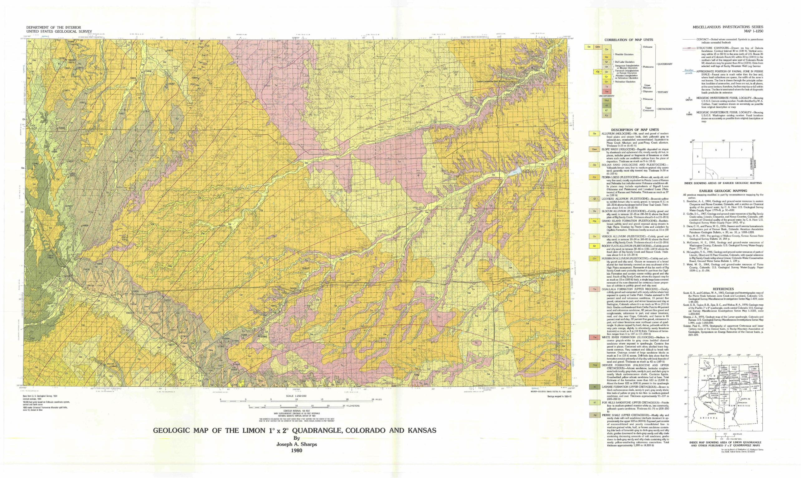
DEPARTMENT OF THE INTERIORUNITED STATES GEOLOGICAL SURVEY
MISCELLANEOUS INVESTIGATIONS SERIESMAP i-1250
30- | 2 900 000 FEET (CENTRAL) { i B ' f
jSi^Rfifgl
1 • ' • ' • •r ' PT—K— H 4—-V
CORRELATION OF MAP UNITS
Qa Qsw
| '.'.Of "
UN
'i-fce-v:
Qp
*lp;Os
Qv
•Or
Qn
To
Tw
:ONTORM
TKd
Kl
Kf
Kp
1> Plnedale Glaclation
J
;- Bull Lake Glaciation
', Sangamon Inierglaciaiionf or Jilinoian Glaciation'̂ Yarmoulh Jnlerglaciation
j, or Kansan Glaciation' Aitonian Inierglaciaiionj or Nebraskan Glacialion
> Nebraskan Glaciationj j
«
*TY
..- Holocene
- Pleetocene
UpperMiocene™.- OliiSOctine
- Paloocene
. Upj»rCretaceous
QUATERNARY
Base from U. S. Geological Survey. 1954Limited revision. 196410.000-fool grids based on Colorado coordinate system,central and north zoneslOOD-meter Universal Transverse Mercator grid ticks,zone 13. shown in blie
SCALE 1:250000
10
INTHICfl-EEQUfitKl SUWEY. RESTON. '/A.—r330-Gifi3E8
Geology mapped in 1963-72
CONTOUR INTERVAL 100 FEETWITH SUPREMEMTAHY CONTOURS AT 50 FOOT HTEHVALS
NATIONAL GEODETIC VEHTCAL DATUM OF 1329
1333 MAGNETIC DECtiHATiOH F03 THIS Sr£ET VABiES HOW 11"30' EASTERLY FOR THE CENTER OF THE WESTEDGE TO lirai' EASTERLY RIB THE CEN'EF |j: HE £,'-,31 ED'.il VEA'J AVJLAL ^-A'.'i: 13 ini-j' 'AtMEHL'r
_25 KILOMETERS
GEOLOGIC MAP OF THE LIMON 1° x 2° QUADRANGLE, COLORADO AND KANSASBy
Joseph A. Sharps1980
^ CRETACEOUS
DESCRIPTION OF MAP UNITSALLUVIUM (HOLOCENE)—Silt, sand and grave! of modern
flood plains and scream beds, dark yellowish gray toyellowish-fan, crossbedded, unconsolidated. Equivalent toPiney Creek Alluvium and post-Piney Creek alluvium.Thickness 0-13 m {(P43 ft)
SLOPE WASH (HOLOCENE}—Regolith deposited on slopesby sheetwash and ephemeral rills; mostly sandy silt but, inplaces, includes gravel or fragments of limestone or shalewhere such rocks are available upslope from the place ofdeposition. Thickness as much as 5 m (15 ft}
EOLIAN SAND (HOLOCENE AND PLEISTOCENE)—Yellowish-brown very fine to medium-grained silty quartzsand; generally more silty toward lop. Thickness 0-30 m(0-100 ft)
PEORIA LOESS (PLEISTOCENE)—Brown silt, sandy silt, andvery fine sand; mostly equivalent to Peoria Loess of Kansasand Nebraska but Includes some Holocene windblown silt.In places may include equivalents of Bigneil Loess{Holocene and Pleistocene) and Loveland Loess (Pleis-tocene) of Kansas and Nebraska. Thickness as much as 37m (120 ft)
LOUVIERS ALLUVIUM (PLEISTOCENE)—Brownish-yellowto reddish-brown silly to sandy gravel; in terraces 8-11 m(25-35 ft) above the stream bed of Deer Trail Creek. Thick-ness about 3-6 m (10-20 ft)
SLOCUM ALLUVIUM (PLEISTOCENE)—Cobbly gravel andsilty sand; in terraces 12-15 m (40-50 ft) above the floodplain of Big Sandy Creek. Thickness about 5-6 m (15^0 ft)
GRAND ISLAND FORMATION (PLEISTOCENE)—Reddish-brown pebbly sand and gravel exposed along streams inHigh Plains. Overlain by Peoria Loess and underlain byOgallala Formation. Thickness locally as much as 15 m (50ft)
VERDOS ALLUVIUM (PLEISTOCENE)—Cobbly gravel andsilty sand; in terraces 18-24 m (60-80 ft) above the floodplain of Big Sandy Creek. Thickness about 5-6 m (15-20 ft)
ROCKY FLATS ALLUVIUM (PLEISTOCENE)—Cobbly graveland silty sand; in terraces 30-46 m (100-150 ft) above theflood plain of Big Sandy Creek and Beaver Creek. Thick-ness about 5-6 m (15-20 ft)
NUSSBAUM ALLUVIUM (PLEISTOCENE)—Cobbly and peb-bly grave! and silty sand. Occurs as remnants of a broadalluvial fan that formerly covered an area southwest of theHigh Plains escarpment. Remnants of this fan north of BigSandy Creek were probably derived in part from the Ogal-lala Formation and contain coarse cobbly gravel and siltysand. South of Big Sandy Creek, where the deposit may beas much as 15 m (100 ft) thick, a single large loess-coveredremnant of the now-dissected fan contains a lesser propor-tion of cobbles in pebbly gravel and silty sand
OGALLALA FORMATION (UPPER MIOCENE)—Chieflycobbly gravel well-cemented with sandy caliche where bestexposed in quarry at Cedar Point. Grades eastward to 80percent sand and calcareous sandstone. 13 percent finegravel, calcareous in part, and minor limestone and clay atBurlington, Colorado where it Is as much as 96 m (315 ft)thick. Grades northeastward from Cedar Point to 44 percentsand and calcareous sandstone, 42 percent fine gravel andconglomerate, calcareous in part, and minor limestone,marl, and clay near Cope, Colorado; and thence to 65percent marl and clay, 32 percent fine gravel, calcareous inpart, and minor limestone near northeasl corner of quad-rangle. In places capped by hard, dense, yellowish-white tovery pale orange, slightly to abundantly sandy limestone(calcrete) as much as 4 m (12 ft} thick. Thickness of forma-tion ranges from 5 to 107 m (17-350 ft)
WHITE RIVER FORMATION (OLIGOCENE)—Medium tocoarse grayish-white to gray cross bedded channelsandstone where exposed in quadrangle. Contains finegravel in places. Cemented with silica; sib'cified bone frag-ments common. Very resistant and difficult to break withhammer. Outcrops consist of large sandstone blocks asmuch as 3 m (10 ft) across. Drill-hole data show that theformation consisls primarily of silty day with local deposits ofsand and gravel. Thickness as much as 45 m (149 ft)
DENVER FORMATION (PALEOCENE AND UPPERCRETACEOUS)—Arkosic sandstone, lenticular conglom-erate beds locally; gray s hale, sandy in part; and dark-gray tonearly black carbonaceous shale. Contains lignite.Crossbedded yellow arkosic sandstone bed at base. Totalthickness of the formation more than 610 m (2,000 ft).About the lower 122 m (400 ft) present in the quadrangle
LARAMIE FORMATION (UPPER CRETACEOUS}—Brown toblack carbonaceous shale, sandy in part; gray sandy shale;thin beds of yellow or gray to tan fine- to medium-grainedsandstone, and coal. Thickness approximately 91-107 m(300-350 ft)
FOX HILLS SANDSTONE (UPPER CRETACEOUS}—Friablefine- to medium-grained massive white or, less commonly,yellowish quartz sandstone. Thickness 61-76 m (200-250ft)
PIERRE SHALE (UPPER CRETACEOUS)—Mostly silty andsandy shale with soft sandstone interbeds dominant In ap-proximately the upper 122 m (400 ft). Exposed part consistsof unconsolidated and poorly consolidated fine- tomedium-grained white, buff, or brown sandstone contain-ing thin beds of brownish-gray to dark-gray sandy and siltyshale; grades downward to dark-gray sandy and silty shalecontaining decreasing amounts of sofl sandstone; gradesdown to dark-gray sandy and stfty shale containing silly tosandy yellow-weathering calcareous concretions. Totalthickness approximalely 1,280 m (4,200 ft}
grandis
— CONTACT—Dotted where concealed. Symbols in parenthesesindicate concealed bedrock
-500 STRUCTURE CONTOURS—Drawn on top of DakotaSandstone. Conlour interval 30 m (100 ft). Vertical accu-racy within 15 m (50 ft) in the area north of U.S. Route 36and west of Colorado Route 63; within 30 m (100 ft) in thenorthern half of the mapped area west of Colorado Route59; elsewhere may be greater than 30 m {100 ft). Data fromselected well logs of Rocky Mountain Well Log Service
- APPROXIMATE POSITION OF FAUNAL ZONE IN PIERRESHALE—Faunal zone is much wider than the line and,where fossil collections are sparse, the width of the zone Isnot known. The line is drawn through the principle collec-tion localities of ammonites, and these are not, in all places,at the same horizon; Iherefore, the line may rise or fall withinthe zone. The line is terminated where the lack of diagnosticfossils precludes iis extension
MESOZOIC INVERTEBRATE FOSSIL LOCALITY—ShowingU.S.G.S. Denver catalog number. Fossils identified by W. A.Cobban. Fossil locations shown as accurately as possiblefrom original description or map
MEZOZO1C INVERTEBRATE FOSSIL LOCALITY—ShowingU.S.G.S. Washington catalog number. Fossil locationsshown as accurately as possible from original description ormap
a15845
INDEX SHOWING AREAS OF EARLIER GEOLOGIC MAPPING
EARLIER GEOLOGIC MAPPINGAll previous mapping modified in part by reconnaissance mapping by the
author.1. Boettcher, A. J., 1964, Geology and ground-water resources in eastern
Cheyenne and Kiowa Counties, Colorado, with a section on Chemicalquality of the ground water, by C. A. Horn U.S. Geological SurveyWater-Supply Paper 1779-N, p. N1^I32.
2. Coffin, D. L_, 1967, Geology and ground-water resources of the Big SandyCreek valley, Lincoln, Cheyenne, and Kiowa Counties, Colorado, witha section on Chemical qualify of the ground water, by C. A. Horr: U.S.Geological Survey Water-Supply Paper 1843, 49 p.
3. Dane, C. H., and Pierce, W. G., 1936, Dawson and Laramie formations insoutheastern part of Denver Basin, Colorado: American AssociationPetroleum Geologists Bulletin, v. 20, no. 10r p. 1308-132S.
4. Elias, M. K., 1931, The geology of Wallace County, Kansas: Kansas StateGeological Survey Bulletin 18, 254 p.
5. McGovern, H. E., 1964, Geology and ground-water resources ofWashington County, Colorado: U.S. Geological Survey Water-SupplyPaper 1777, 46 p.
6. McLaughlin, T. G., 1946, Geology and ground-water resources of parts ofLincoln, Elbertand H Paso Counties, Colorado, with special referenceto Big Sandy Creek valley above Limon: Colorado Water ConservationBoard, Ground Water Series Bulletin 1, 139 p.
7. Weist, W. G., 1964, Geology and ground-water resources of YumaCounty, Colorado: U.S. Geological Survey Water-Supply Paper1539-J. p. J1-J56.
REFERENCESScott, G. R., and Cobban, W. A., 1965, Geologic and biostratigraphic map of
the Pierre Shale between Jarre Creek and Loveland, Colorado: U.S.Geological Survey Miscellaneous Investigations Series Map 1-439, scale1:48,000.
Scott, G. R., Taylor, R. EL Epis, R. C., and Wobus, R. A., 1978, Geologic mapof the Pueblo 1° x 2° quadrangle, south-central Colorado: U.S. Geologi-cal Survey Miscellaneous Investigations Series Map 1-1022, scale1:250,000.
Sharps, J. A., 1976, Geologic map of the Lamar quadrangle, Colorado andKansas: U.S. Geological Survey Miscellaneous Investigations Series Map1-944, scale 1:250,000.
Soister, Paul E., 1978, Stratigraphy of uppermost Cretaceous and lowerTertiary rocks of the Denver basin, in Rocky Mountain Association ofGeologists. Symposium on Energy Resources of the Denver basin, p.223-229.
0 ICO 2CO KILOMETERS
INDEX MAP SHOWING AREA OF LIMON QUADRANGLEAND OTHER PUBLISHED la x 2° QUADRANGLE MAPS
Fo- sale t'f Drench ci Disirinulicn, 1.5. Geclogcfi Survey.
i v m , CO li/J^G