Embed Size (px)
Citation preview
Mission Planning for aGPS Control Survey Using ESRI ArcMap
August 8, 2004Mickie Warwick, PLS

Using ArcMap for GPS Mission Planning
• Surveyors are not tapping into the benefits that can be derived from using GIS
• Many presentations aimed at ‘bridging the gap’ show how survey data can be used to improve the accuracy of a GIS project
• This presentation will show how GIS was used to expedite a GPS Cadastral survey.

The Project
• GLO notes for Pre-European Settlement ecological conditions – Don Bragg, Forest Reseacher USDA Forest Service
• Geographic Coordinate Data Base (GCDB)
• Standards for the National Map and FGDC• GCDB• Standards for GPS Surveys
The Project

Standards and Guidelines for Cadastral Surveys Using Global
Positioning System Methods
May 9, 2001
United States Department of Agriculture – Forest ServiceUnited States Department of Interior – Bureau of Land Management

Local Accuracy Standards
II. Cadastral Measurements
Less than 0.100m
I. Cadastral Project Control
Less than 0.050m
Application95% Confidence Circle
Local accuracy is a measure of the relative accuracies of the coordinates for a point with respect to adjacent points at the 95% confidence level.

Network Accuracy Standards
II. CadastralMeasurements
Less than 0.200m
I. Cadastral Project Control
Less than 0.100m
Application95% Confidence Circle
The network accuracy shows the relationship of the cadastral survey relative to the National Spatial Reference System.

Standards and Guidelines for Cadastral Surveys Using Global Positioning System Methods
• Standards developed to provide guidance to Cadastral Surveyors in the use of carrier phase GPS technology to perform Public Land Survey System (PLSS) surveys on public lands
• Representatives of the U.S.D.A. Forest Service and the Bureau of Land Management jointly developed these standards and guidelines. They include other federal agencies, including the National Geodetic Survey, existing GPS control survey standards and guidelines, and opinions and reviews from other public and private land surveyors who use GPS for cadastral (boundary) surveys.
• Cadastral surveys are a critical part of the National Spatial Data Infrastructure. These standards and guidelines are in accordance with the accuracy reporting requirements of the Federal Geographic Data Committee's "Geospatial Positioning Accuracy Standards," July, 1997.

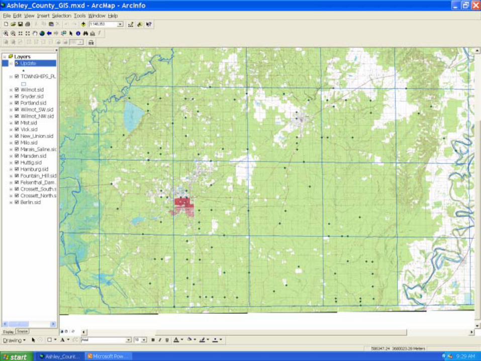
Gathering Basic Resources
From the Spatial Analysis Lab at the University of Arkansas at Monticello
• USGS 7.5 minute quadrangle maps
• Color Infrared aerial photography


I. Cadastral Project Control
• Horizontal and Vertical Control Datasheets from the National Geodetic Survey
• Paper copies of the datasheets for use in the field
• Downloaded points in GIS format for the map and to import coordinates into Resource Grade GPS for Reconnaissance


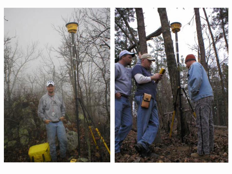
Checking for overhead cover

Fieldwork
• Requirement for at least two High Accuracy Reference Network (HARN) points - easy to find because the horizontal coordinates are really good
• Requirement for at least one vertical control monument in each quadrant of the job –preferably just outside and surrounding the project area – to help define the geoid


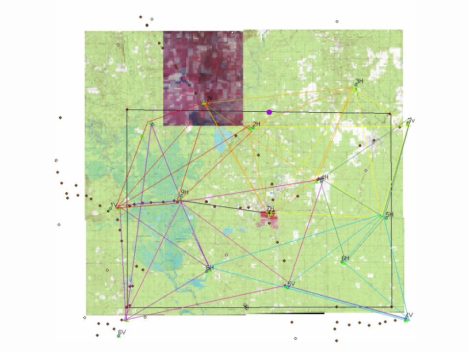
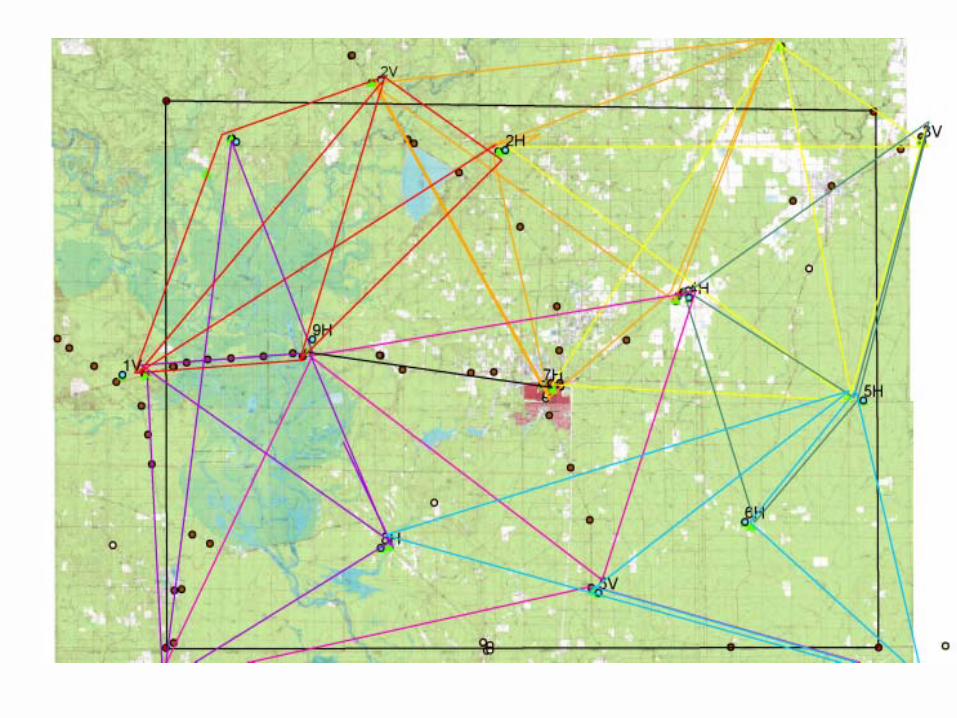
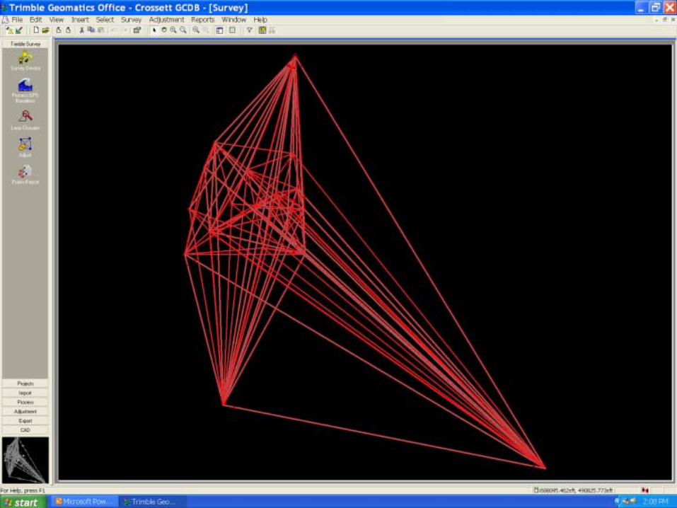
Planning the GPS Sessions• Every point must be occupied at least twice with a
percentage being observed three times – redundancy (Cadastral Standards)
• Using existing or newly set monuments, the sessions are planned using GIS
• Computations are made to determine the number of sessions that will be necessary (Van Sickle – GPS for Surveyors)
• The baseline vectors can be measured on the map to determine the approximate time of occupation on each point (Wolf & Ghilani – Elementary Surveying textbook)
• Routes for each observer are determined and a schedule is made

4:45 PM3:00 PM12:30 PM10:45 AM9:00AMSTOP TIME
3:45 PM2:00 PM11:30 AM9:45 AM8:00 AMSTART TIME
1V9H5H4H7H5. Mickie Warwick
9H4H4V5H5H4. James Barnett
6V6V8H4V2H3. Jason Beck
8H5V6H6H3V2 Kevin Hicks
1H7H5V3V3H1. Bill Gagner
SESSION 5SESSION 4SESSION 3SESSION 2SESSION 1OBSERVER
SATURDAY MARCH 6, 2004 ASHLEY COUNTY


II. Cadastral Measurements
• Data from corner cards at the State Surveyors Office
• Survey Plats from State Surveyors Office and County Courthouse
• Records at Potlatch Timber Company in Warren• Records at Plum Creek Timber Company in
Crossett• Map from Arkansas Game and Fish – Felsenthal
Wildlife Management Area

Nov. 26, 1986394April. 28,1842A. Bowman17S08W600600E-2128W17S
May. 20, 1982394May. 6, 1842A. Bowman17S08W200440L-5188W17S
April. 30, 1982394May. 7, 1842A. Bowman17S08W240600E-758W17S
June. 12, 1985394Dec. 24, 1827N. Rightor17S08W700640C-2518W17S
July. 9, 1987394Jan. 8, 1828N. Rightor17S07W540100Z-19357W17S
May. 10, 1982394Mar. 1, 1841A. Bowman17S07W500200V-17347W17S
April. 30, 1982394Mar. 1, 1841A. Bowman17S07W500240T-17277W17S
July. 9, 1987394Feb. 27, 1841A. Bowman17S07W700300R-25257W17S
May. 10, 1982394Mar. 1, 1841A. Bowman17S07W500300R-17227W17S
May. 10, 1982394Feb. 28, 1841A. Bowman17S07W600600E-2127W17S
Mar. 9, 1984394Jan. 13, 1841A. Bowman17S06W340300R-11216W17S
July. 9, 1987394Jan. 15, 1841A. Bowman17S06W100300R-1 196W17S
July. 9, 1987394Jan. 15, 1841A. Bowman17S06W140300R-3196W17S
Mar. 9, 1984394Jan. 10, 1841A. Bowman17S06W500500J-17106W17S
Sept. 20, 1984394Jan. 27, 1841A. Bowman17S06W200540G-576W17S
May. 10, 1982394Jan. 14, 1841A. Bowman17S06W300600E-946W17S
Mar. 9, 1984394Jan.11, 1841A. Bowman17S06W500600E-1736W17S
Sept. 15, 1990394Jan. 3, 1840John Clark17S05W600200V-21265W17S
Nov. 6, 1986394Jan. 4,1840Andrew B Clark17S05W500300R-17265W17S
Jan. 30, 1991394Jan. 23, 1840John Clark17S05W400540G-1395W17S
Mar. 10, 1984394Jan. 26, 1840John Clark17S05W300500J-985W17S
Mar. 10, 1984394Jan. 28, 1840John Clark17S05W200700A-565W17S
Date_SetPLS_No.Date_Org.Org._SurveyorGCDB_CodeIndexSectionRangeTnwp


The use of GIS significantly reduced the time it took to plan and execute a GPS
survey to meet the Cadastral Standards for
GPS and there was “benefit added”.
Conclusion