Embed Size (px)
Citation preview

MISSOURIresources
Spring / Summer 2012 • Volume 29 • Number 2
efforts will be pivotal in keeping costsdown and integral to the mission ofthe department. Energy use is a sig-nificant cost to operate Missouri stateparks. By reducing one of our biggestexpenses, we are leading the way to abrighter future for our beloved parks.
In this issue of Missouri Resources,you can learn more about energy effi-ciency, Camp Smart and theAbout.com award. So, gather up yourfishing, hiking and camping gear andmake plans today to explore and cele-brate our Missouri state parks.
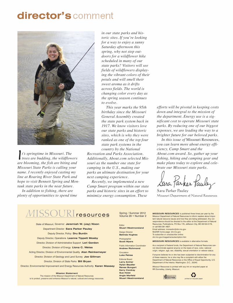
It’s springtime in Missouri. Thetrees are budding, the wildflowers
are blooming, the fish are biting andMissouri State Parks is calling yourname. I recently enjoyed casting myline at Roaring River State Park andhope to visit Bennett Spring and Mon-tauk state parks in the near future.
In addition to fishing, there areplenty of opportunities to spend time
in our state parks and his-toric sites. If you’re lookingfor a way to enjoy a sunnySaturday afternoon thisspring, why not step out-doors for a wildflower hikescheduled in many of ourstate parks? Visitors will seefields of wildflowers display-ing the vibrant colors of theirpetals and will smell theirsweet aroma as it driftsacross fields. The world ischanging color every day asthe spring season continuesto evolve.
This year marks the 95thbirthday since the MissouriGeneral Assembly createdthe state park system back in1917. We know visitors loveour state parks and historicsites, which is why they wereranked as one of the top fourstate park systems in thecountry by the National
Recreation and Parks Association.Additionally, About.com selected Mis-souri as the number one state forcamping in the U.S., making ourparks an ultimate destination for yournext camping experience.
Recently, we implemented a newCamp Smart program within our stateparks and historic sites in an effort tominimize energy consumption. These
director’s
Sara Parker Pauley
Missouri Department of Natural Resources
State of Missouri, Governor Jeremiah W. (Jay) Nixon
Department Director Sara Parker Pauley
Deputy Director, Policy Dru Buntin
Deputy Director, Operations Leanne Tippett Mosby
Director, Division of Administrative Support Lori Gordon
Director, Division of Energy Llona C. Weiss
Acting Director, Division of Environmental Quality Alan Reinkemeyer
Director, Division of Geology and Land Survey Joe Gillman
Director, Division of State Parks Bill Bryan
Director, Environmental Improvement and Energy Resources Authority Karen Massey
printed on recycled paper
EditorStuart Westmoreland
Design DirectorBelinda Hughes
PhotographerScott Myers
Public Information CoordinatorAndrew Richmond
CirculationLuke Petree
Editorial BoardLarry ArcherHylan BeydlerRenee BungartKerry CordraySue HolstAngie MorfeldStuart Westmoreland
MISSOURI RESOURCES is published three times per year by theMissouri Department of Natural Resources to inform readers about impor-tant natural resource issues and how they are being addressed. Any cor-respondence should be directed to the editor at the Department of NaturalResources, Publications, PO Box 176, Jefferson City, MO 65102-0176, or call 800-361-4827. Email address: [email protected] MoDNR home page: dnr.mo.govTo subscribe or unsubscribe online:dnr.mo.gov/magazine/subscription.htm
MISSOURI RESOURCES is available in alternative formats.
As a recipient of federal funds, the Department of Natural Resources can-not discriminate against anyone on the basis of race, color, national origin, religion, age, sex, disability, sexual orientation or veteran status.
If anyone believes he or she has been subjected to discrimination for anyof these reasons, he or she may file a complaint with either theDepartment of Natural Resources or the Office of Equal Opportunity, U.S.Department of the Interior, Washington, D.C., 20240.
Missouri Resources is printed with soy ink on recycled paper at RR Donnelley, Liberty, Missouri.
Mission StatementThe mission of the Missouri Department of Natural Resources
is to protect, preserve and enhance Missouri’s natural, cultural and energy resources.
Spring / Summer 2012Volume 29 • Number 2

Above: At Mark Twain State Park, visitors can enjoy recreational activities such as water skiing, swimming, fishing, boating and camping.Front Cover: Watkins Woolen Mill State Historic Site is the only completely intact 19th-century American woolen mill in the country.Back Cover: This photo illustration shows what Missouri’s state dinosaur, Hypsibema missouriensis, may have looked like during the lateCretaceous period, the end of the age of dinosaurs. The original, life-size model was created by Guy Darrough of Lost World Studios.DNR photos by Scott Myers.
departments14 News Briefs 20 Resources to Explore 23 Career Connection 25 One Last Word
2 Small Steps; Big Rewardsby Dalena Hardy
The Energize Missouri Industries program put $5.6 million in federal funding into the hands of Missouri businesses.
6 The Value of Geologic Mappingby Joe Gillman
State-of-the-art geologic maps have the potential to create $200 million in economic value for Missouri.
8 Operation Efficiencyby Dalena Hardy
The Energy Independence and Security Act of 2007 requires federal facilities to reduce total energy use 30 percent by 2015.
10 Fountains of Truthby Kerry Cordray
Four hundred groundwater observation stations and river and stream gauges keep a close watch on Missouri’s water.
2 Missouri Resources
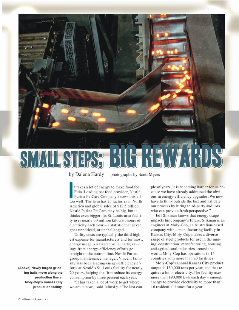
It takes a lot of energy to make food forFido. Leading pet food provider, NestléPurina PetCare Company knows this all
too well. The firm has 23 factories in NorthAmerica and global sales of $12.5 billion.Nestlé Purina PetCare may be big, but itthinks even bigger. Its St. Louis-area facili-ty uses nearly 30 million kilowatt hours ofelectricity each year – a statistic that nevergoes unnoticed, or unchallenged.
Utility costs are typically the third high-est expense for manufacturers and for most,energy usage is a fixed cost. Clearly, sav-ings from energy-efficiency efforts gostraight to the bottom line. Nestlé Purinagroup maintenance manager, Vincent Jalin-sky, has been leading energy-efficiency ef-forts at Nestlé’s St. Louis facility for nearly20 years, helping the firm reduce its energyconsumption by three percent each year.
“It has taken a lot of work to get wherewe are at now,” said Jalinsky. “The last cou-
ple of years, it is becoming harder for us be-cause we have already addressed the obvi-ous in energy-efficiency upgrades. We nowhave to think outside the box and validateour process by hiring third-party auditorswho can provide fresh perspective.”
Jeff Silkman knows that energy usageimpacts his company’s future. Silkman is anengineer at Moly-Cop, an Australian-basedcompany with a manufacturing facility inKansas City. Moly-Cop makes a diverserange of steel products for use in the min-ing, construction, manufacturing, housingand agricultural industries around theworld. Moly-Cop has operations in 15countries with more than 70 facilities.
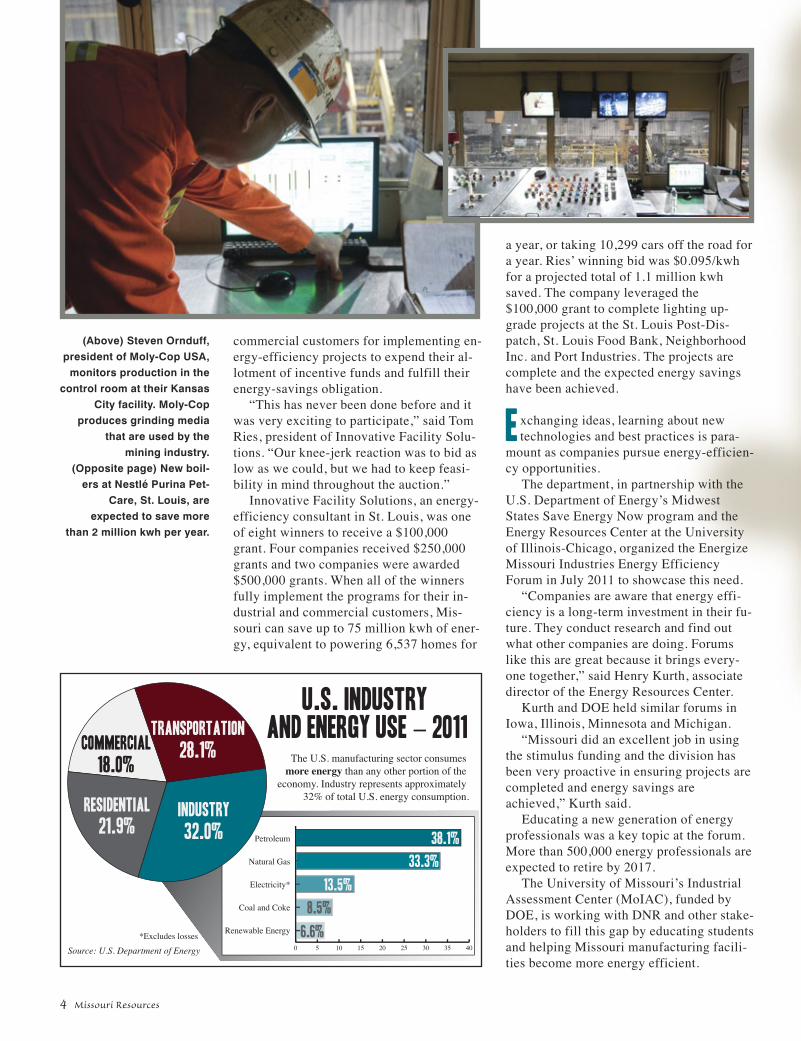
Moly-Cop’s annual Kansas City productoutput is 130,000 tons per year, and that re-quires a lot of electricity. The facility usesmore than 190,000 kwh each day – enoughenergy to provide electricity to more than16 residential homes for a year.
by Dalena Hardy photographs by Scott Myers
(Above) Newly forged grind-ing balls move along the
production line at Moly-Cop’s Kansas City
production facility.
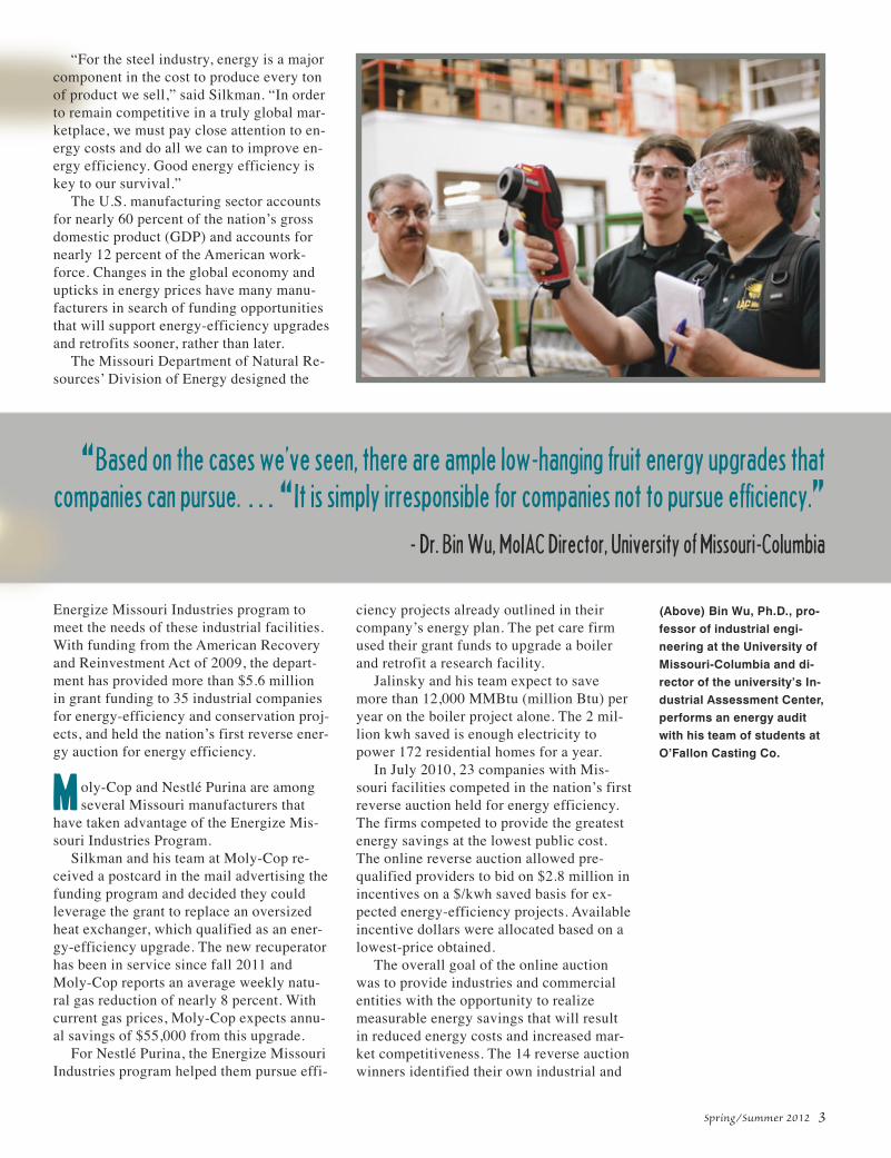
“For the steel industry, energy is a majorcomponent in the cost to produce every tonof product we sell,” said Silkman. “In orderto remain competitive in a truly global mar-ketplace, we must pay close attention to en-ergy costs and do all we can to improve en-ergy efficiency. Good energy efficiency iskey to our survival.”
The U.S. manufacturing sector accountsfor nearly 60 percent of the nation’s grossdomestic product (GDP) and accounts fornearly 12 percent of the American work-force. Changes in the global economy andupticks in energy prices have many manu-facturers in search of funding opportunitiesthat will support energy-efficiency upgradesand retrofits sooner, rather than later.
The Missouri Department of Natural Re-sources’ Division of Energy designed the
Energize Missouri Industries program tomeet the needs of these industrial facilities.With funding from the American Recoveryand Reinvestment Act of 2009, the depart-ment has provided more than $5.6 millionin grant funding to 35 industrial companiesfor energy-efficiency and conservation proj-ects, and held the nation’s first reverse ener-gy auction for energy efficiency.
Moly-Cop and Nestlé Purina are amongseveral Missouri manufacturers that
have taken advantage of the Energize Mis-souri Industries Program.
Silkman and his team at Moly-Cop re-ceived a postcard in the mail advertising thefunding program and decided they couldleverage the grant to replace an oversizedheat exchanger, which qualified as an ener-gy-efficiency upgrade. The new recuperatorhas been in service since fall 2011 andMoly-Cop reports an average weekly natu-ral gas reduction of nearly 8 percent. Withcurrent gas prices, Moly-Cop expects annu-al savings of $55,000 from this upgrade.
For Nestlé Purina, the Energize MissouriIndustries program helped them pursue effi-
ciency projects already outlined in theircompany’s energy plan. The pet care firmused their grant funds to upgrade a boilerand retrofit a research facility.
Jalinsky and his team expect to savemore than 12,000 MMBtu (million Btu) peryear on the boiler project alone. The 2 mil-lion kwh saved is enough electricity topower 172 residential homes for a year.
In July 2010, 23 companies with Mis-souri facilities competed in the nation’s firstreverse auction held for energy efficiency.The firms competed to provide the greatestenergy savings at the lowest public cost.The online reverse auction allowed pre-qualified providers to bid on $2.8 million inincentives on a $/kwh saved basis for ex-pected energy-efficiency projects. Availableincentive dollars were allocated based on alowest-price obtained.
The overall goal of the online auctionwas to provide industries and commercialentities with the opportunity to realizemeasurable energy savings that will resultin reduced energy costs and increased mar-ket competitiveness. The 14 reverse auctionwinners identified their own industrial and
Spring/Summer 2012 3
“Based on the cases we’ve seen, there are ample low-hanging fruit energy upgrades that
companies can pursue. … “It is simply irresponsible for companies not to pursue efficiency.”- Dr. Bin Wu, MoIAC Director, University of Missouri-Columbia
(Above) Bin Wu, Ph.D., pro-fessor of industrial engi-neering at the University ofMissouri-Columbia and di-rector of the university’s In-dustrial Assessment Center,performs an energy auditwith his team of students at O’Fallon Casting Co.
4 Missouri Resources
commercial customers for implementing en-ergy-efficiency projects to expend their al-lotment of incentive funds and fulfill theirenergy-savings obligation.
“This has never been done before and itwas very exciting to participate,” said TomRies, president of Innovative Facility Solu-tions. “Our knee-jerk reaction was to bid aslow as we could, but we had to keep feasi-bility in mind throughout the auction.”
Innovative Facility Solutions, an energy-efficiency consultant in St. Louis, was oneof eight winners to receive a $100,000grant. Four companies received $250,000grants and two companies were awarded$500,000 grants. When all of the winnersfully implement the programs for their in-dustrial and commercial customers, Mis-souri can save up to 75 million kwh of ener-gy, equivalent to powering 6,537 homes for
a year, or taking 10,299 cars off the road fora year. Ries’ winning bid was $0.095/kwhfor a projected total of 1.1 million kwhsaved. The company leveraged the$100,000 grant to complete lighting up-grade projects at the St. Louis Post-Dis-patch, St. Louis Food Bank, NeighborhoodInc. and Port Industries. The projects arecomplete and the expected energy savingshave been achieved.
Exchanging ideas, learning about newtechnologies and best practices is para-
mount as companies pursue energy-efficien-cy opportunities.
The department, in partnership with theU.S. Department of Energy’s MidwestStates Save Energy Now program and theEnergy Resources Center at the Universityof Illinois-Chicago, organized the EnergizeMissouri Industries Energy EfficiencyForum in July 2011 to showcase this need.
“Companies are aware that energy effi-ciency is a long-term investment in their fu-ture. They conduct research and find outwhat other companies are doing. Forumslike this are great because it brings every-one together,” said Henry Kurth, associatedirector of the Energy Resources Center.
Kurth and DOE held similar forums inIowa, Illinois, Minnesota and Michigan.
“Missouri did an excellent job in usingthe stimulus funding and the division hasbeen very proactive in ensuring projects arecompleted and energy savings areachieved,” Kurth said.
Educating a new generation of energyprofessionals was a key topic at the forum.More than 500,000 energy professionals areexpected to retire by 2017.
The University of Missouri’s IndustrialAssessment Center (MoIAC), funded byDOE, is working with DNR and other stake-holders to fill this gap by educating studentsand helping Missouri manufacturing facili-ties become more energy efficient.
0 5 10 15 20 25 30 35 40
Petroleum
Natural Gas
Electricity*
Coal and Coke
Renewable Energy
38.1%
33.3%
8.5%
6.6%
13.5%
Industry
32.0%
Transportation
28.1%
Residential
21.9%
Commercial
18.0%The U.S. manufacturing sector consumes
more energy than any other portion of the economy. Industry represents approximately
32% of total U.S. energy consumption.
U.S. Industry and Energy Use – 2011
Source: U.S. Department of Energy
*Excludes losses
(Above) Steven Ornduff,president of Moly-Cop USA,
monitors production in thecontrol room at their Kansas
City facility. Moly-Cop produces grinding media
that are used by the mining industry.
(Opposite page) New boil-ers at Nestlé Purina Pet-
Care, St. Louis, are expected to save more
than 2 million kwh per year.

During the next five years, the MoIAC intends to send teamsof professors and students to 150 facilities to conduct ener-
gy-efficiency audits that will result in annual savings of morethan $70,000 per facility.
“Based on the cases we’ve seen, there are ample low-hang-ing fruit energy upgrades that companies can pursue. The im-mediate impact of our energy audits of companies is substan-tial – $80,000 a year in energy savings is really equal to$800,000 a year in new sales, assuming an average profit mar-gin of ten percent,” said Dr. Bin Wu, director of MoIAC and aprofessor of industrial engineering at the University of Mis-souri-Columbia. “It is simply irresponsible for companies notto pursue efficiency.”
Wu reports that his graduating students are now leading en-ergy efforts for their employers.
By strategically incorporating energy-efficiency improve-ments into production and business planning, Missouri manu-facturers are increasing cost savings and raising productivity.These improvements also enhance their competitivenessthroughout the global marketplace.
Dalena Hardy is a former division information officer for thedepartment’s Division of Energy.
Spring/Summer 2012 5
Energize Missouri Industries RecipientsAwards for Energy-Efficiency Projects
ABB Inc. $49,500Able Manufacturing $104,127AC Buckhorn LLC $159,859Anheuser-Busch Inc. $750,000Bodine Aluminum Inc. $605,000Boulevard Brewing Co. $91,948Buchheit Inc. $40,196Buckman USA $45,261
* Cascades Plastics Inc. $71,000Continental Casting LLC $123,850Continental Cement Co. $50,000
* Covidien Pharmaceuticals $578,481Dura Automotive Systems $15,000Elantas PDG Inc. $46,480Everlast Sports Mfg. Corp. $12,000Family Center Warehouse $8,912Henniges Automotive $53,379
* Hubbell Power Systems $148,014Insteel Industries Inc. $71,672K&S Wire Products Inc. $10,264LMC Industries $50,000Mississippi Lime Co. $355,254Missouri Plating Co. $112,479
* Nestlé Purina PetCare $636,214* New World Pasta $562,647
Noranda Aluminum Inc. $50,000Moly-Cop $250,000Rexam Food Containers $53,000Sigma-Aldrich $50,000Springfield Remanufacturing Corp. $30,000SSM DePaul Health Center $318,887Standard Transportation Services $19,237Thorco Industries $15,000
* Unilever $30,000R.R. Donnelley $49,500
*Company received two awards
Energize Missouri Reverse Auction WinnersAwards for Energy-Use Reductions for
Industrial and Commercial Customers
$500,000 Awards• Ameren Missouri, $0.0325/kwh• The Gasket Guy dba Green Energy Masters,
$0.0325/kwh
$250,000 Awards • 8760 Energy Engineering LLC, $0.0294/kwh • Eco Engineering LLC, $0.0299/kwh • Missouri Enterprise, $0.0275/kwh • Murphy Company Mechanical Contractors,
$0.0275/kwh
$100,000 Awards• HTE Technologies, $0.0900/kwh • Innovative Facilities Solutions, $0.095/kwh• Schaeffer Marketing Group Inc., $0.100/kwh• Ozark Energy Services, $0.1050/kwh• Energy Solutions Inc., $0.1050/kwh• Zeller Technologies Inc., $0.1098/kwh• Metropolitan Energy Center, $0.1100/kwh• Blue Sky Lighting Products LLC, $0.1100/kwh

S ince 1993, the division has partici-pated in the National CooperativeGeologic Mapping Program to pro-
duce state-of-the-art geologic map products.These efforts have the potential for produc-ing nearly $200 million in economic valuefor Missouri.
Geologic maps are graphic tools that uselines, colors, and symbols to provide an in-terpretive, three-dimensional view of therock, sediment and soil that make up our en-vironment. These maps, produced by the
department’s Division of Geol-ogy and Land Survey, depictrock type, distribution, proper-ties and its relative age. Theyprovide information about theEarth’s structure and provide abaseline for data related to en-ergy resources, mineral re-sources, natural hazards, waterresources, soil conservationand climate science. Virtuallyall mineral, energy, water, in-dustrial construction, publicworks and urban developmentprojects can benefit from a ge-ologic map.
The information containedon a geologic map can be usedto characterize the geology of alocation within the context of asurrounding region. Scientists
can then use this information to construct apredictive model not only of that location,but also of the surrounding regions wheresimilar data may be limited or unavailable.
This allows map users to make informeddecisions based on scientific data. For ex-ample, geologic maps can help engineersand planners identify surface and rock ma-terials that will provide suitable foundationsfor the construction of bridges, dams, tun-nels, pipelines and highways. Geologicmap-based information is essential to the
6 Missouri Resources
The Value of Geologic Mapping
Cross-Section of Bedrock Geologic Map of Fulton, Mo.
This portion of the cross section from the Bedrock Geologic Map of Fulton shows a vertical slice of the Earth. It identifies different rock formations, landscapetopography, and depicts time periods by showing the sequence of sedimentary rocks. The oldest rocks are on the bottom and the youngest on top.
Elevation in feet indicates feet above sea level.
by Joe Gillmanphotographs by Scott Myers
Geologist Fletcher Bone,with the department’s Divi-sion of Geology and Land
Survey, takes notes during asite visit to an area near
Finger Lakes State Park inBoone County.

Spring/Summer 2012 7
evaluation of the vulnerability of water-sheds to contamination. Missouri’s geologyis complex, and understanding the geologyof a particular watershed provides the foun-dational quantitative attributes of the char-acter and nature of the materials in the sub-surface. Interpretation of a particularwatershed’s geologic characteristics can in-dicate the nature of the surface water orgroundwater interaction and its vulnerabili-ty to contaminants. It can identify the oc-currence of mineral or energy resources thatmay one day be of interest for developmentand thus require approaches that ensure sus-tainable protection.
These maps also can help landowners,farmers and government agencies locateand protect groundwater resources. Theycreate a regional picture of the geologic ma-terials that store groundwater or providerecharge to groundwater aquifers.
“Geologic maps are the foundation ofAmerica’s infrastructure,” said KevinEvans, Ph.D. and associate professor of ge-ology with Missouri State University inSpringfield. “If it weren’t for bedrock andsurficial sediment maps, some bridges andbuildings could be at risk of collapse, andpoorly positioned sanitary landfills couldspoil our safe drinking water. One such ca-tastrophe is too many.”
Quality geologic mapping reduces uncer-tainty and leads to the informed applicationof regulatory rules that protect the environ-ment and human health. Identifying geolog-ic conditions such as subsurface faulting,high permeability bedrock and areas sus-ceptible to geologic hazards can help elimi-nate locations being considered for solidwaste or wastewater treatment facilities.
Derivative maps also can begenerated from geologic
maps by extracting selected infor-mation or by expanding on theprimary data of a specific issue.Maps that show areas prone tokarst development, erosion orlandslides can reduce the risk as-sociated with the construction ofhomes, businesses and transporta-tion routes.
In addition, detailed geologicmaps allow scientists to generateseismic hazard maps that showgeologic materials that are likelyto shake during an earthquake.
Geologic maps also help de-fine the occurrence and distribu-tion of energy and mineral re-sources and help determinestrategies for development andenvironmental protection. Theyalso provide information used toadvance strategies of economicdevelopment based on the geo-logic conditions. The maps alsohave a considerable economic,societal and scientific value.Cost-benefit studies show that thevalue of a geologic map is 25 to39 times the cost to produce themap, and developers and engi-neers can save about $50,000 perproject when modern geologicmaps are available.
Joe Gillman is director of the de-partment’s Division of Geologyand Land Survey and serves asstate geologist for Missouri.
Bedrock GeologicMap of Fulton, Mo.
This portion of the stratigraphic column fromthe Bedrock Geologic Map of Fulton identifiesdifferent rock formations and depicts time peri-ods by showing the sequence of sedimentaryrocks. At the top is the Fort Scott Subgroup(youngest), which is composed of limestone.Older cherty clay, sandstone, refractory clay,coal, sand, pyrite, other limestone and variousdeposits lie between it and the Cotter andJefferson City Dolomites (oldest) at the bottomof the column. The graphic covers approxi-mately 500 feet in depth. See an online,detailed map at dnr.mo.gov/geology/statemap/stLouis/OFM-07-523-GS.htm.
Fort Scott Subgroup
Cabaniss Subgroup
Cheltenham Formation,Graydon Conglomerate, and Warner Formation
Burlington-KeokukLimestone
Chouteau GroupBachelor FormationSnyder Creek Shale
Cedar Valley Limestone
St. Peter Sandstone
Cotter and Jefferson City Dolomites
Pfs, Pc, Pbf = Carboniferous Period (Pennsylvanian Subsystem) Dsc and Dcv = Devonian PeriodMbk = Carboniferous Period (Mississippian Subsystem) Osp and Ocj = Ordovician Period
DN
R m
ap b
y D
GLS
Geo
logi
cal S
urve
y P
rogr
am
DN
R m
ap b
y D
GLS
Geo
logi
cal S
urve
y P
rogr
am

8 Missouri Resources
OPERATIONEFFICIENCYBUILDING A GREENER MILITARY
by Dalena Hardy
duce their vehicle fleets’ total consumptionof petroleum by two percent annuallythrough the end of fiscal 2015 as comparedto fiscal 2005. The Energy Independenceand Security Act of 2007 requires federalfacilities to reduce total energy use by 30percent by calendar year 2015.
The National Defense Authorization Actof 2010 requires DoD to produce or procure25 percent of its total facility energy usefrom renewable sources beginning in 2025.Energy professionals have been gearing up.
“I made a binder of all the legislation,executive orders and memos and it has got-ten pretty thick,” said Amy Crews, environ-mental engineer at Fort Leonard WoodArmy Post. “Honestly, it took us some timeto get our heads around it all.”
Fort Leonard Wood, located in south-central Missouri, is a thriving installationthat has evolved from a small basic trainingpost 70 years ago, to a state-of-the-art, U.S.Army-designated Center of Excellence. TheFort trains nearly 90,000 military personneland civilians each year. One of the leadingemployers and the economic engine for theregion, it employs more than 9,000 DoDpersonnel, contractors and other civilians.
“We only have so much space given tous,” said Crews. “Fifty-plus years from nowwe will still be using this land to train, there-fore, we take stewardship very seriously.”
Fort Leonard Wood teamed up with theU.S. Army Corps of Engineers to designand construct the Prime Power Schoolwhich trains soldiers to install, operate andmaintain medium-voltage electrical powerplants. The Prime Power School is FLW’sfirst Leadership in Energy and Environmen-
A s the nation’s largest energy user,the Department of Defense (DoD)is exploring a wide range of inno-
vations to enhance energy security and im-prove operation effectiveness. Chief amongthese efforts is deploying energy-efficientand renewable-energy technologies at mili-tary bases worldwide.
Today, DoD is undertaking aggressiveenergy-efficiency goals that are enforced byfederal executive orders and legislation.
Executive Order 13423 (2007) requiresfederal agencies to reduce energy intensityby three percent annually or 30 percent bythe end of fiscal 2015, as compared to a fis-cal 2003 baseline. Agencies also must re-
Whiteman Air Force Basepersonnel replace damaged
and outdated insulation onsteam heat distribution
pipes. This upgrade resulted in considerable
energy savings.
U.S
. Air
Forc
e ph
oto

Spring/Summer 2012 9
(Top) Home to the AirForce’s fleet of B-2 StealthBombers, Whiteman re-placed the enormous doorseals on hangars, resultingin nearly $150,000 annualenergy cost savings.(Above) Because of its ener-gy-efficient, sustainable de-sign, the Prime PowerSchool facility at FortLeonard Wood was awarded a LEED®
Gold designation.
tal Design, or LEED® building. The post isrequired to build new facilities to at least thestandards of the LEED Silver designation,but were able to attain Gold, one level high-er. LEED is a point-based system in whichbuilding projects earn LEED points for sat-isfying specific green building criteria.
Fort Leonard Wood has incorporated sus-tainable features into existing facilitiesthrough its Energy Saving PerformanceContract (ESPC). This agreement providesthird-party financing to conduct energyprojects with the guarantee that a project’scost will be paid for by its energy savings.
Fort Leonard Wood’s ESPC projectshave included lighting upgrades, low-con-sumption appliances and enhanced heatingand air conditioning units. Through theseprojects, FLW will save more than $36 mil-lion over the 20-year contract period.
Not to be outdone, the Air Force’s ener-gy-efficiency efforts have also taken flightin Missouri. It is attempting to reduce ener-gy consumption, increase energy supply andeducate base personnel on being an energy-conserving community.
The overarching goal of Whiteman AirForce Base, located in west-central Mis-
souri, is committed to reducing energy con-sumption, improving infrastructure and pro-viding mission support. Whiteman currentlyis home to the 509th Bomb Wing and is theonly home air force base for the B-2 Ad-vanced Technology Bomber.
“When we are given direction, we useour resources to ensure that everything getsdone,” said 1st Lt. Rachel Savage, publicaffairs deputy for the 509th Bomb Wing.
While thebase is commit-ted to DoD ener-gy goals, thegrowth of thebase and size ofits missionmakes cutting 30percent of energyuse by 2015 apossible, but dif-ficult task.
Whiteman im-plemented a$15.2 million en-ergy program last year, the largest in AirForce Global Strike Command, which iscomposed of five bases. In 2010, the baseexecuted $12.4 million in energy projectswith an estimated annual utility savings of$1.1 million by 2012.
To reduce energy demand, Whiteman hasupgraded or replaced old, inefficient lightfixtures and exchanged high-voltage bulbswith energy-efficient versions, among otherupgrades. Recently, the base installed newhangar door seals on 21 structures. The an-ticipated annual savings from the door sealsalone equals 6,700 kwh and a savings ofnearly $150,000 per year.
Energy remains a key strategic consider-ation for the Department of Defense, andMissouri’s military bases are doing theirpart to increase efficiency and cut energycosts and consumption.
Dalena Hardy is a former division informa-tion officer for the Department of NaturalResources’ Division of Energy.
U.S
. Air
Forc
e ph
oto/
Ken
ny H
olst
on
DN
R p
hoto
by
Sco
tt M
yers

10 Missouri Resources
Within just a few miles of virtual-ly every Missouri reader of thisarticle, there is a small array of
equipment, an observation station activelytracking the rise and fall of a local ground-water or stream level. A water level reading,often along with a measurement of localrainfall or other weather data, is loggedevery 30 minutes on each station’s smallcomputer module. The data are then trans-mitted by a small UHF radio unit to a satel-lite in geostationary orbit 26,000 milesabove the equator. The information is thenbeamed to Earth, received at a station inLittle Rock, Ark. operated by the U.S. Geo-logical Survey.
The USGS feeds all readings into a com-puter, where they are translated into tablesand graphic displays and posted on the In-ternet. Whether the data are being measuredat the local observation station or directedto a display on the Web, the chain of eventstakes only a few seconds.
In Missouri, more than 400 stations makeup the network of groundwater observationstations and river and stream gauges thathelp state and local authorities understandand manage our water resources. All thegroundwater monitoring stations are operat-ed and maintained by staff of the MissouriDepartment of Natural Resources’ WaterResources Center. The USGS and other fed-eral, state, municipal and local partnersmaintain the stream observation gauges.
Watching the WaterWhy is there such an organized effort to
take regular measurements of Missouri’swater resources at so many locations aroundthe state? Compared to many other states,Missouri has vast amounts of surface waterand underground water resources. But theseresources are not infinite.
“Good management and stewardship ofany resource starts with good science, in-cluding an accurate measurement of the re-source over time – knowing how muchthere is, how and where it is distributed, andhow much is being used,” said RyanMueller, director of the department’s WaterResources Center.
Stream gauges track the depth of riversand streams, ranging from those on the Mis-souri and Mississippi rivers to numeroussmaller rivers and streams across the state.
“The National Weather Service reliesheavily on stream gauge information toissue flood watches, warnings and forecastson major rivers and streams,” said Mueller.“River forecasters combine river stage in-formation with the amount of anticipated
by Kerry Cordrayphotographs by Scott Myers
Fountains of Tru(Right) While it may
not look the part,this stone observa-
tion shelter at Bennett Spring
State Park is also an active water
monitoring gauge. (Opposite page) Astream gauge also
is located on theMeramec River in
Montauk State Park,a popular and
historic destinationfor trout fishermen.

rain [in order] to model when and howquickly rivers will rise or fall. Streamgauges are then used to verify the actualriver stages so future flood forecasts can beprepared and issued.”
The department provides funding to op-erate 43 of the 254 stream gauges statewide.This includes gauges located at BennettSpring, Montauk and Roaring River stateparks. Those three gauges provide currentstream information that helps anglers,campers, floaters and other visitors plan fortheir outdoor experiences. The state parkgauges also collect flow measurementsfrom the large springs feeding the parks’recreational streams. These data help hy-drologists learn how spring flow respondsto precipitation.
Measuring the UnseenKeeping track of river and stream levels
is essential, but it’s equally important to in-crease our understanding of Missouri’s vitalgroundwater resources. Total groundwateruse in Missouri may easily exceed 350 bil-lion gallons of water per year. More than 80percent of Missouri’s public water suppliesuse groundwater, and it supplies nearly allof Missouri’s rural residents who use indi-vidual private water supplies.
Most of Missouri’s groundwater moni-tors measure a depth from the land surfacedown to groundwater using a mechanicalsystem involving a float, a stainless steeltape, pulleys, counterweights and a digitalencoder to record the up-and-down move-ments of the float. The equipment is pow-ered by batteries that are recharged by thesun through a photovoltaic panel. A few ofthe wells record their data using equipmentthat translates a water pressure reading frombelow the surface of the groundwater into adepth measurement.
The monitors are installed in wells,measuring the levels in aquifers that rangefrom less than 30 feet down, to deeperbedrock aquifers more than 1,800 feetdeep. Of the 164 current groundwater moni-toring wells, 10 were drilled by the depart-ment specifically to track groundwater lev-els near areas of increased water use. Butmost groundwater monitoring wells wereonce local wells. These wells were loanedor donated to the department by cities, ruralwater districts and other landowners who nolonger needed them for supplying water.
Making sure all those groundwater moni-tors run “ship shape” is a large part of thejob of Scotty Baumgartner, a Water Re-sources Center hydrologist.
“We visit each site twice a year for regu-lar scheduled maintenance and calibration.
Spring/Summer 2012 11
th
Sites with rain gauges get two additionalvisits a year for cleaning,” said Baumgart-ner. “In addition, we know within one tofour hours if one of our stations has mal-functioned. Those sites receive immediateattention to ensure that we collect high-quality, complete data sets.”
Adding to the established monitoringnetworks, in 2009 and 2010 the departmentinstalled and began operating monitoringstations at six wetland sites. Two of the sitesare in Pershing and Van Meter state parks,while the others are in state conservationareas. Funded by a U.S. Environmental Pro-
tection Agency grant and in coop-eration with the University of Mis-souri, the sites are part of a specialstudy to help scientists understandthe relationships between waterlevels, soil conditions and otherconditions in Missouri’s wetlandsystems. Data about groundwater,rainfall and other weather condi-tions from these sites will continue
to be monitored and made available afterthe study is concluded.
From Decent Data to Sound Science
Among the miracles of the informationage, massive amounts of water resourcedata are now instantly available in nearlyreal-time form via the Web. Major waterusers like irrigators and industries con-cerned with availability of water from theirwells may see level fluctuations and howquickly or slowly the aquifer that suppliesthem recharges. Municipalities can adjustthe schedules and distribution of theirpumping for drinking water supplies. Evenpaddling enthusiasts can check stream fore-casts to see if waters are rising or falling be-fore scheduling an upcoming float.
For online maps and links to streamgauges, groundwater monitors and otherwater resource information, visit DNR’swebsite at: www.dnr.mo.gov/env/wrc.
Even more importantly, having useful in-formation about our water resources is thefirst step toward helpful science. Scientistssuch as hydrologists, geologists and meteo-rologists use these data many ways.
“The public is most immediately inter-ested in rising or falling waters when we gothrough the extremes of flooding ordrought,” said department hydrologist Char-lie DuCharme. “But having the data is justas important when we study longer-term fu-ture water supplies and needs.”
The department’s Water Resources Cen-ter uses the data as it works with regionalplanning organizations and water commis-sions to help them develop long-term, sus-tainable water supplies critical for the socialand economic well being of Missourians.Since the droughts of 2003 and 2005,groups in several areas of the state havestudied water supplies and water usage asthey considered how to manage regionalwater supplies and planned to meet antici-pated future needs.
A regional group called the Tri-StateWater Resource Coalition, formed in south-west Missouri, northeast Oklahoma andsoutheast Kansas, has performed a series ofstudies since 2003, investigating potentialwater sources to meet the needs of its mem-ber communities.
Across a 12-county swath of northwestMissouri, county and municipal representa-tives banded together in 2006 to develop a
12 Missouri Resources
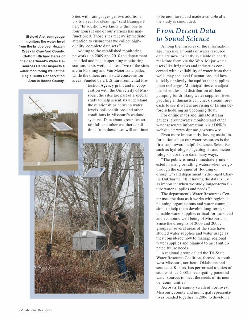
(Below) A stream gaugemonitors the water level
from the bridge over HuzzahCreek in Crawford County.(Bottom) Richard Bates of
the department’s Water Re-sources Center inspects a
water monitoring well at theEagle Bluffs Conservation
Area in Boone County.

regional water supplyplan for the area. Thatpartnership incorporatedin 2009 as the GreatNorthwest WholesaleWater Commission, andbegan to plan a pipelinetransmission system tomove water from theMissouri River to com-munities across that 12-county region.
“Many rural commu-nities need expensivewater system replace-ments, and those that areoperating their ownwater supplies often can-not get through a dry spell longer than twoyears,” said Steve McIntosh, an environ-mental manager for the department. “Inter-connections and regional water systems are
Winter 2011 13
a critical need for rural drinking water andcommunity fire protection.”
Delving Deeper“The advances in monitoring and model-
ing capabilities provide us better data forwater supply planning and decision mak-ing,” said Mueller. “But a gap still exists inunderstanding how much water is used,from what areas, over what time periodsand for what purposes.”
To fill this gap, the Water ResourcesCenter collects and uses data about wateruse. Missouri law requires any water userwith the capability to withdraw 70 gallonsper minute or greater from any water source(100,000 gallons per day) to register withthe department and to report their water useeach year. The data reported help re-searchers study changes and impacts toMissouri’s water resources.
“Reporting water use also helps the indi-vidual water users, helping them identifyunintended overuse or water losses that maycause increased energy use and higher costsfor system maintenance or treatment,” saidMueller. “Reporting water use helps docu-ment the water needs of the users duringtimes of shortage or dispute – or if thereshould come a time when water use be-comes regulated.”
Should that day arrive, it is comforting toknow that these Fountains of Truth aresources of more than just water. They are, infact, in-depth reporters.
Kerry Cordray is a division information of-ficer for DNR’s Water Resources Centerand Soil and Water Conservation Program.
(Top right) Richard Bates calibrates a monitoring well data recorder.(Above) Bates and Scotty Baumgartner, also with the Water Re-sources Center, measure the groundwater depth at anothermonitoring well in Columbia.

Missouri Voted Top Statefor Camping
The people havespoken: Missouri isthe No. 1 state forcamping in the U.S.About.com, a reference website main-tained by the New York Times Compa-ny, announced the results of its annualReaders’ Choice Award for FavoriteState for Camping, and Missouri tooktop honors. Missouri took the web-site’s gold award. The silver winnerwas Montana and bronze went to Col-orado, in an online vote.
“The First Lady and I are proud thatMissouri has been selected as arenowned camping destination,” Gov.Jay Nixon said. “Missouri is the perfectplace to enjoy the great outdoors.”
“This is yet another solid indicatorthat Missouri State Parks is the ulti-mate destination for your next camp-ing experience,” said Bill Bryan, direc-tor of Missouri State Parks, a divisionof the Department of Natural Re-sources. “Our parks and historic sitesoffer an impressive glimpse of the nat-ural and cultural beauty throughoutour state.”
Now in its fifth year, the About.comReaders’ Choice Awards honor thebest products, features and servicesacross more than a dozen categories,ranging from technology to hobbies toparenting and more, as selected by itsreaders. “This year’s Readers’ ChoiceAwards program had a record numberof nominations submitted acrossdozens of categories and featuredhundreds of finalists,” said MargotWeiss, managing editor, About.com.“We are thankful to all our readers fortheir participation and congratulateMissouri on their success.”
StormAware WebsiteLaunched
The State Emer-gency ManagementAgency announced thelaunch of a new website tohelp inform and prepare Mis-sourians for severe weather.
StormAware includes detailed videoson how to take shelter in specifictypes of buildings, important informa-tion about tornado sirens and weatheralert radios, and links to severe weath-er texting services that can alert peo-ple across Missouri to upcoming se-vere weather.
“We think Missouri StormAware willbe a valuable tool to educate all Mis-sourians about the steps they cantake to help protect themselves fromdangerous severe weather,” StateEmergency Management Agency Di-rector Paul D. Parmenter said.
The text messaging services, whichare not provided by the State of Mis-souri, are free, but normal text mes-saging rates will apply. For more infor-mation, visit the StormAware websiteat stormaware.mo.gov.
Mercury Roundup TimeEnds Soon!
Homeowners look-ing for a safe wayto rid their homesof mercury haveuntil the end of May to take advantageof the Missouri Department of NaturalResources’ mercury roundup.
Working with 50 fire departmentsand county health offices throughoutthe state, the department is providingmercury drop-off locations in commu-nities statewide. Any private citizen ornonprofit agency can leave mercury-containing instruments, such as ther-mometers, blood pressure cuffs, ther-mostats or switches, at any of thesesites. Citizens seeking to dispose ofitems at these sites should first securethe item in two zip top plastic bagsand then place them in a crush-proofsealed container, such as a coffeecan, plastic margarine tub or plasticbeverage bottle.
Department staff will collect thedropped off items at the end of Mayfor consolidation. Staff will then trans-port the mercury items to JeffersonCity to recycle and properly disposeof the rest. A person who is uncom-fortable with transporting mercury in-struments, or who has large quantities
of mercury, can contact the depart-ment’s spill line at 573-634-2436 toarrange to have items picked up. A listof mercury drop-off location sites isavailable at dnr.mo.gov/env/esp/mercuryroundup-dnr.htm. Contact thenearest participating agency or DNR’sEnvironmental Services Program at573-634-2436 for more information.
Neosho Awarded $9.4Million Low-Interest Loan
The Depart-ment of NaturalResources hasawarded Neoshoa $9.4 millionlow-interest loan
to improve its drinking water system.The city will use the loan to replaceaging drinking water distribution lines,provide a backup power supply for thepump stations, upgrade the treatmentplant to meet current and future stan-dards and add chemical feed systemsto all wells. The project is estimated tocost $9.4 million and is expected to becompleted in January 2013.
Funding for the loan comes fromthe Drinking Water State RevolvingFund. A portion of the money will betargeted toward green infrastructure,water and energy efficiency and envi-ronmentally innovative projects.
The department is committed toworking closely with communities toassist with funding efforts that supportwater and wastewater infrastructureimprovement projects, as well as pro-vide a financial savings. For more in-formation contact the department’sWater Protection Program, FinancialAssistance Center, PO Box 176, Jeffer-son City, Mo. 65102-0176 or call 800-361-4827, or visit the program’s web-site at dnr.mo.gov/env/wpp/srf.
Geologic Maps PublishedFive new geologic maps are avail-
able for portions of Lincoln and St.Charles counties. The department’sDivision of Geology and Land Surveycreated the maps through theSTATEMAP component of the NationalCooperative Geologic Mapping Pro-
14 Missouri Resources
news

gram, which is co-funded by the U.S.Geological Survey.
Surficial material maps are avail-able for Defiance, Maryknoll and theWinfield quadrangles. Bedrock mapsare available for the Wentzville andMaryknoll/Winfield quadrangles.
Bedrock geologic maps provide in-formation about the existing layering ofbedrock and faulting, folding or defor-mation. They include information aboutthe distribution of rock such as lime-stone, sandstone, coal and granite.
Surficial material maps describedeposits that occur above bedrock.This includes soil, but also details upto several hundred feet of deeper un-consolidated material.
Geologic maps are used in applica-tions including agriculture, water avail-ability, earthquake and other naturalhazard evaluation, industrial and com-mercial development siting, waste dis-posal facilities and economic assess-ment of our natural resources.
Visit missourigeologystore.com topurchase these or other geologic ortopographic maps, or call 573-368-2100. You also can visit the Division ofGeology and Land Survey at 111 Fair-grounds Road in Rolla.
Permit Modifications ListAvailable Online
Facilities or busi-nesses that activelytreat, store – for morethan 90 days – or dis-pose of hazardouswaste in Missouri must get a haz-ardous waste permit, which lists howand what kinds of hazardous wastethe facility can manage. It also liststhe facility’s operating conditions andclosure, corrective action and financialassurance requirements. The depart-ment or the facility can make changesto the hazardous waste permitthroughout its life. Permit modifica-tions are labeled as Class 1, 2 or 3,depending on how much they changethe original permit conditions. Thepublic is invited to review the Depart-ment of Natural Resources’ list of allapproved hazardous waste permit
modifications for calendar year 2011.The permit modifications list is onlineat dnr.mo.gov/env/hwp/permits/publications.htm. For more informa-tion or a hardcopy of the list, contactthe department’s Hazardous WasteProgram at 800-361-4827. Hearing-and speech-impaired individuals mayreach the department through RelayMissouri at 800-735-2966.
Online Workshops SaveEnergy for Municipalities
The Missouri Department of NaturalResources offered a series of work-shops on building energy codes andstandards that could help Missourimunicipalities save billions in energycosts. The department’s Division ofEnergy focused its workshops on theresidential and commercial building
Spring/Summer 2012 15
environmental notes
It seems the jury is out on whether taking a bathrather than a shower uses less water, but if shower-ing is your ritual of choice there are few options toconsider. With only one percent of the water on ourplanet being fresh water, it is easy to see the impor-tance of reducing waste. Conserving our freshwater supply ensures there is plenty to go aroundand reduces energy used to process wastewaterthat is washed down the drain. An easy way to save
a boatload of water when showering is to borrow some wisdom straight from theU.S. Navy.
On a ship, fresh water is scarce, so conserving what is available is extremely im-portant for the entire crew. Approximately 25 gallons of water per person, per day isrequired for cooking, drinking, washing and bathing when out at sea. Making freshwater on a naval vessel is also an extremely expensive, inefficient undertaking. Theprocess requires boiling seawater to remove salt. A “Navy shower” is the easiestway for the crew to save water when sailing the seven seas.
Taking a Navy shower is easy. You begin with an initial 30-second rinse, thenshut off the water while soaping and lathering. Finally, the water is turned on for aquick final rinse. In comparison, a standard “Hollywood Shower,” where conserva-tion is not a concern, can use as much as 60 gallons of water. A Navy shower cancut water consumption down to as little as 3 gallons of water. While taking oneshower a day over a year’s time, Navy showers can equate to a savings of approxi-mately 20,000 gallons of water when compared to a standard shower.
While this method may seem a little extreme to most, the principles behind it aresound and can be applied to any daily bathroom routine in a variety of ways. Low-flow showerheads can cut water consumption to as little as one-half gallon perminute. While no special hardware is needed to practice a full-blown Navy shower,a variety of showerheads designed specifically for this purpose can be purchasedat most hardware stores. These heads include a cut-off switch for stopping the flowof water without requiring you to re-regulate your water temperature for the finalrinse. Other conservation methods include setting a timer so you know how longyou’ve been showering, as well as setting your water heater to 120 F to save ener-gy used to heat water.
Conserving fresh water not only ensures a lasting supply, but also helps tolower the energy cost burden on all citizens. To reach this goal, make an effort topractice good water conservation habits, both at home and at work.
news
Rub-A-Dub-Dub; Save Water When You Scrub

16 Missouri Resources
news
LettersOnce a month, time and weather permitting, we take a
short trip – typically one day – to see sites of local historical orscientific interest. While we were aware of the famous meteorcrater in Arizona, we had no idea that Missouri also had mete-or craters, until the latest issue of Missouri Resources arrived.
For each outing, we put together slides of the trip to sharewith friends and relatives. We enjoy your magazine, especiallythe articles that bring our attention to something that we canvisit with just a day trip from our home in Aurora. A friend laterpointed me to the link, missourigeologists.org/, which hassome very nice geological guides that I will reference if we get to make a return visit.
These kinds of excursions would make great outings forBoy Scouts and school geological field trips.
Gene BallayAurora
Editor’s Note: Gene attached some great photos from his Decaturville Im-
pact Structure visit. As with any field trip, the department re-minds you to respect the rights of private property owners andask for permission in order to access areas outside publiclands, roads and right-of-ways.
Just read through the Winter 2012, “Missouri Resources.” Ithas been a lot of years since I walked through the Mark TwainCave and studied a few geology classes, but on the topic ofmaze caves, I have to wonder if the cave at MontegawSprings, might not also qualify as a maze cave? A lot of pas-sages at 90 degrees in that one.
Speaking of caves, your “Time Exposures” asserts thatSmallin Cave has the largest opening. Probably, but I was at acave once to the fairly immediate southeast of Climax Springs,that also had a huge opening. My foggy memory would haveit, at least half of the dimensions you cite for Smallin, and sub-stantial in its own right.
I also enjoyed the article on the structures along the 38thparallel. I got to visit the Decaturville dome on a college fieldtrip 40+ years ago. I don’t recall at the time that our instructorhad connected the dots with the other features stretching fromIllinois, over into Kansas. Also then read the Geologists FieldTrip Guidebook, 51st Annual Meeting, Rolla, Mo., Oct. 1-2,2004. So now I’m all up to speed on that topic. Anyway, darngood issue.
David SalmonBelton
I just read your article, “Extraterrestrial Visitors,” in yourwinter issue, and enjoyed it very much. When I saw the graph-ic on impact structures, I noticed the site in Kansas was veryclose to where my “rock” was found. I was an Allen County
Commissioner in the 1975 to 80s period, and the road supervi-sor brought it to me, knowing of my interest in such things. Itwas found in the county quarry in the rock crusher, which wasnot able to break it. The combination quarry and landfill is lo-cated about 35 miles west of Fort Scott, Kan. I took it to thephysics department at Missouri Southern several years ago.The professor examined it, and could not determine its con-tent. It is magnetic, weighs between six and seven pounds andis roughly 3.5 by 2.75 by 2 inches in size. I wonder if it couldbe a meteorite. Should you have any interest in examining it,please let me know.
Phyllis DeTarCarl Junction
Editor’s Note: Division of Geology and Land Survey staff in Rolla examined
Phyllis’s interesting rock and found it too low in nickel to be ameteorite. The abundant, heavy iron content of the stone was aferrous metal of manmade origin.
What a super issue, Winter 2012. I teach 7th grade EarthScience for NWR1 school district. This issue covers so muchthat I will be teaching it in March and April. I don’t know whatyour policy is about sending multiple copies. If it is possible,could I have 35 copies to use in my class? I will share themwith the other 7th grade teacher, too. If there is a cost in-volved, please let me know. I love your magazine and read itcover to cover, every issue.
Patty RosellValley Middle SchoolHouse Springs
Editor’s Note: We do not charge to deliver extra copies to teachers for
classroom use. To minimize waste, we do ask that teachershave the students subscribe to receive the magazine at home,and bring that copy to school for classroom study when re-quested. This way, the students and their family continue to re-ceive Missouri Resources after they move to the next grade,and teachers can request a new list each year. Teachers alsocan access online versions of Missouri Resources for class-room use at dnr.mo.gov/magazine.
Letters intended for publication should be addressed to “Letters,” Missouri Resources, PO Box 176, Jefferson City, MO 65102-0176 or faxed to(573) 522-6262, attention: “Letters.” Please include your name, address and daytime phone number. Space may require us to edit your letter.You also can email Missouri Resources staff at [email protected].
standards developed for the Interna-tional Energy Conservation Code. Thedepartment selected a team of build-ing experts to provide several work-shops from November 2011 throughFebruary 2012 in St. Louis, Spring-field, Kansas City and Columbia. Inaddition to the workshops, the depart-ment held corresponding webinars.All presentations and webinars can beviewed on our website at dnr.mo.gov/energy/energycodes.htm. For more in-formation about building codes andstandards, contact the department’sDivision of Energy at 573-526-5017 oremail [email protected].
“Camp Smart” in Missouri State Parks
Missouri State Parks isimplementing a green ini-tiative called “CampSmart” that will help boththe state park andcampers. This effort en-courages visitors to help conserve en-ergy, protect the environment andsave money. Reducing energy use willhelp Missouri State Parks keep camp-ing fees low. During the season, color-ful “Camp Smart” decals will appearon campground electric pedestals,providing tips to save energy whenvisitors are away from their campsite.Every visitor will be able to do theirpart to help minimize wasted energyat the campground and decrease over-all energy consumption. Energy use isa significant cost to operate Missouristate parks. Visit mostateparks.com tolearn more about camping in a Mis-souri state park.
Missouri Natural AreasCelebrate 35th Birthday
Missouri natural areasare celebrating their 35thbirthday and the invitedguests are visitors to Missouristate parks. Missouri naturalareas are recognized asthe best remaining exam-ples of our state’s original natural en-vironments and are managed and pro-tected for their scientific, educational
Spring/Summer 2012 17
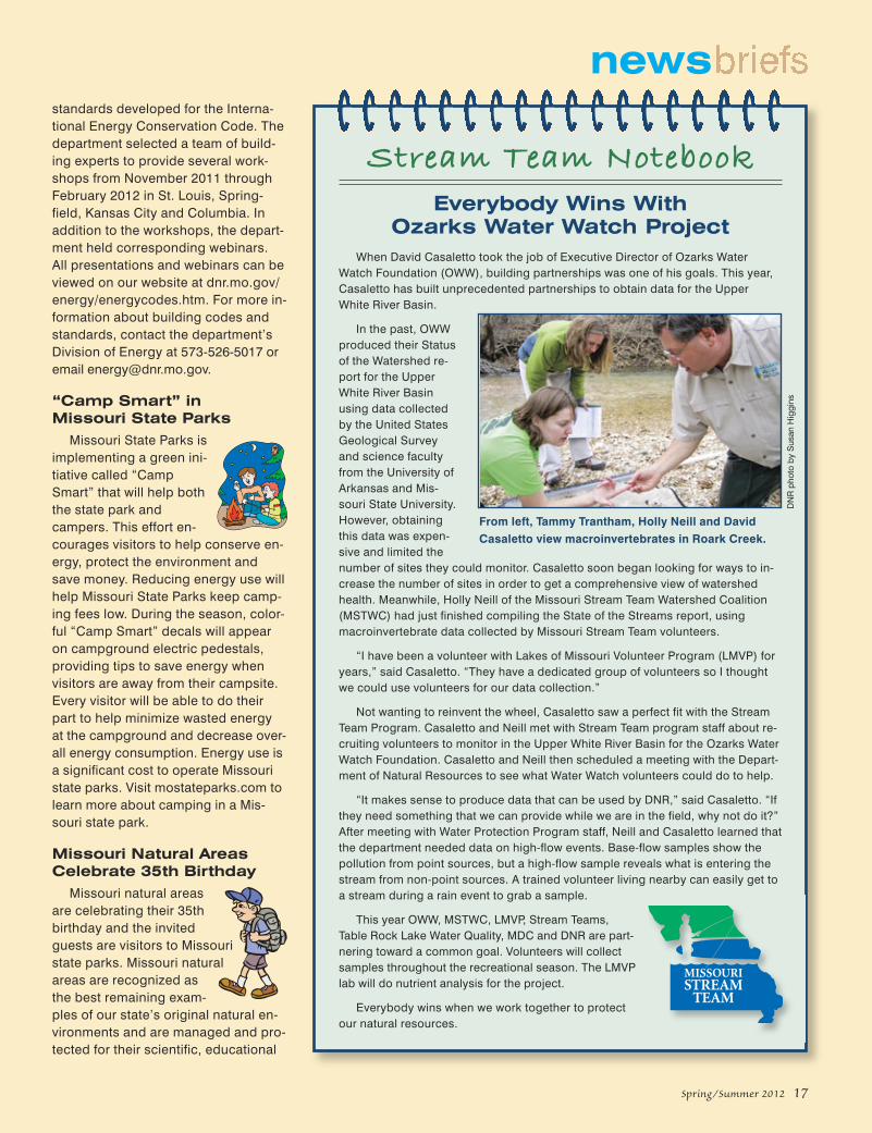
When David Casaletto took the job of Executive Director of Ozarks WaterWatch Foundation (OWW), building partnerships was one of his goals. This year,Casaletto has built unprecedented partnerships to obtain data for the UpperWhite River Basin.
In the past, OWWproduced their Statusof the Watershed re-port for the UpperWhite River Basinusing data collectedby the United StatesGeological Surveyand science facultyfrom the University ofArkansas and Mis-souri State University.However, obtainingthis data was expen-sive and limited thenumber of sites they could monitor. Casaletto soon began looking for ways to in-crease the number of sites in order to get a comprehensive view of watershedhealth. Meanwhile, Holly Neill of the Missouri Stream Team Watershed Coalition(MSTWC) had just finished compiling the State of the Streams report, usingmacroinvertebrate data collected by Missouri Stream Team volunteers.
“I have been a volunteer with Lakes of Missouri Volunteer Program (LMVP) foryears,” said Casaletto. “They have a dedicated group of volunteers so I thoughtwe could use volunteers for our data collection.”
Not wanting to reinvent the wheel, Casaletto saw a perfect fit with the StreamTeam Program. Casaletto and Neill met with Stream Team program staff about re-cruiting volunteers to monitor in the Upper White River Basin for the Ozarks WaterWatch Foundation. Casaletto and Neill then scheduled a meeting with the Depart-ment of Natural Resources to see what Water Watch volunteers could do to help.
“It makes sense to produce data that can be used by DNR,” said Casaletto. “Ifthey need something that we can provide while we are in the field, why not do it?”After meeting with Water Protection Program staff, Neill and Casaletto learned thatthe department needed data on high-flow events. Base-flow samples show thepollution from point sources, but a high-flow sample reveals what is entering thestream from non-point sources. A trained volunteer living nearby can easily get toa stream during a rain event to grab a sample.
This year OWW, MSTWC, LMVP, Stream Teams,Table Rock Lake Water Quality, MDC and DNR are part-nering toward a common goal. Volunteers will collectsamples throughout the recreational season. The LMVPlab will do nutrient analysis for the project.
Everybody wins when we work together to protectour natural resources.
From left, Tammy Trantham, Holly Neill and DavidCasaletto view macroinvertebrates in Roark Creek.
Everybody Wins With Ozarks Water Watch Project
Stream Team Notebook
DN
R p
hoto
by
Sus
an H
iggi
ns
news

the tallgrass prairie and all the plantsand animals that live there, includingbison, elk and prairie chicken. Ele-phant Rocks Natural Area in ElephantRocks State Park makes a big impres-sion with huge pink granite bouldersstrewn across a few acres like a giantnatural playground. Lincoln Hills Natu-ral Area at Cuivre River State Parkshows visitors a little bit of the north-ern Missouri historic mixture of prairie,savanna, woodlands, glades, sink-holes, bluffs and streams. MudlickNatural Area in Sam A. Baker StatePark is a complex of old-growthforests, open woodlands, deepcanyons, igneous cliffs, glades andthe impressive Mudlick Mountain.
For more information on Missouristate park natural areas, visitmostateparks.com.
Energy-EfficiencyMeasures in State Parks
Missouri State Parks is pursuinggreen practices to reduce energycosts in the state park system. Thesecost-saving and energy-reducingpractices currently are being imple-mented at three parks in Missouri.
Funds from the federal AmericanRecovery and Reinvestment Acthelped identify and implement com-prehensive energy-saving projects atBennett Spring, Roaring River andMeramec state parks. Each projectuses state-of-the-art photovoltaic pan-els, high SEER (Seasonal Energy Effi-ciency Rating) heating and coolingsystems, high-efficiency waterheaters, smart electronic control sys-tems and state-of-the-art lighting tech-nology. These projects allow MissouriState Parks to show visitors what ener-gy-efficiency measures can be imple-mented in their own home or business.
and historical values. The MissouriNatural Areas Program was first estab-lished in 1977 as a multi-agency com-mittee to identify and protect theseareas all across the state.
In Missouri state parks, there are 38designated natural areas encompass-ing almost 22,000 acres. Natural areas
do more than preserve natural land-scapes – they also provide hiking trailsand other recreation opportunities.
Here are several natural areas withnumerous trails to experience. RegalTallgrass Prairie Natural Area at PrairieState Park offers an opportunity to ex-perience the grandeur and vastness of
18 Missouri Resources
news
For news releases on the Web, visit:dnr.mo.gov/newsrel/.
For a complete listing of the department’supcoming meetings, hearings and events, visitthe department’s online calendar at:dnr.mo.gov/calendar/search.do.
Looking for a job in natural resources?Go to: dnr.mo.gov/hr/.
Time Exposures
In 1904, the Louisiana Purchase Exposition, also known as the St. LouisWorld’s Fair, began after a delayed opening in 1903. The fair took place onwhat are now the grounds of Forest Park and Washington University and wasthe largest World’s Fair to date. Approximately 1,500 temporary buildingswere constructed of a plaster of Paris and hemp fiber mixture called “staff,”as well as almost 75 miles of walkways and roads within the fairgrounds. Itwas said that it was impossible to see the entire fair in less than a week.
The fair included exhibits from 62 foreign countries, as well as the then 45U.S. states, and featured anything from educational and scientific displays todemonstrations of new industries, theater troupes and music. It has evenbeen claimed that the waffle-style ice cream cone was invented and madepopular at the fair.
The photo above is a stereograph image taken from a view that looksdown the West Cascade and across Grand Basin on the fairgrounds. Everyminute, 45,000 gallons of water would flow down the Cascades and intoGrand Basin. The building in the distance is the Palace of Education and So-cial Economy that covered eight acres on the east side of the Basin. Insidethe palace were live displays of actual classes in session, ranging fromkindergarten to university courses, as well as exhibits exploring pressing is-sues like housing, labor and health. This image is part of a collection ofstereographs published by the H.C. White Co., Bennington, Vt., and residesin the Library of Congress’ stereograph card collection.
Send your photo to “Time Exposures,” c/o Missouri Resources, PO Box 176, Jefferson City,MO 65102-0176. Original photos will be returned via insured mail. Pre-1970 environmental andnatural resource photos from Missouri will be considered. Please try to include the dateand location of the picture, a brief description and any related historic details that might beof interest to our readers.

W hat began with a Newsweek article eventually led to changeat Central High School in Springfield, Mo. Students in the
school’s television production program produced a story for Cen-tral Intelligence that took a close look at the air quality around theirsouthwest Missouri school.
“Students did 100 percent of the research from there,” said NicholeLemmon, faculty advisor for the Central High School’s biweekly televi-sion show, Central Intelligence. Student producers Lydia Berns andMitchell Trafford gathered information on which pollutants were float-ing in the air around their high school campus and examined thethreats they could pose to classmates and teachers. They even inter-viewed a local physician on camera for information on possible health risks.
The segment, “Alarming Air,” has brought real change to the campusof Central High School. “The story was really big in our community.We received lots of attention,” said Lemmon. “Since the story aired,our school has really vamped up our Green Team and has worked tocreate more green space around our buildings.”
When a retired administration building on campus was demolished,the decision was made to leave the area as green space instead ofturning it into a parking lot. There also is an active greenhouse oncampus where plants are grown for replanting throughout classroom
buildings, helping toclean the school’s airof harmful pollutants.The video segmentwas so well producedthat it also won anaward from theNational Academy ofTelevision Arts andSciences, Mid-America EmmyAssociation. Theassociation gives 15high school awardseach spring, and “Alarming Air” took the news category prize. In addi-tion, it was awarded the National Scholastic Press Association’s 2010“News Story of the Year” award.
Central Intelligence has won a total of 18 student Emmy awards in thelast three years, including “Best Overall Show” in 2011, which is morethan any school in the U.S. Most recently, Central Intelligence alsotook “Best of Show” at the 2011 National Scholastic PressAssociation’s national convention, as well as their third consecutive“Pacemaker Award.” For more information about Central Intelligenceand to view “Alarming Air,” head to their website at www.chsci.com.
Resource Honor Roll Central High School
news
RockMatters
F ireclay is a clay-rich sedimentary rock that contains a highpercentage of aluminum oxide, which makes it very resistant
to the effects of high temperatures. It is usually massive (not lam-inated or layered) and fractures into blocky or irregular frag-ments. Common colors include buff, yellow, red, green or brown.However, good, useable fireclay is usually white, cream-colored,gray, or almost black. The four types of fireclay (each progres-sively higher in aluminum oxide or alumina content) are:
Plastic clay – soft and, when wet, has the characteristics of a modeling clay.
Flint clay – compact, smooth, and usually gray, tan or white incolor. It will not slake or “dissolve” in water like plastic clay.
Burley clay – similar to flint clay but contains many small, hard,pod-like “burls” which are concentrations of alumina. These burls are hard enough to scratch glass.
Diaspore clay – the richest in alumina and is commonly buff col-ored, earthy and coarse, with burls concentrated in a porousmatrix. It is very rough to the touch.
Fireclay The abundance of clay-rich sedimentaryrock, known as fireclay, enabled 19th century brick mak-
ers in St. Louis, Mexico, Fulton and other regions ofMissouri to manufacture large quantities of brick and
firebrick for worldwide use. Photo by ANH Refractories
East-central Missouri possesses one of the largest reserves ofhigh-quality fireclay in the world. Most Missouri fireclays canwithstand being heated to temperatures greater than 3000° Fwithout melting. Refractory products made from fireclay are ofvital importance to the steel industry as linings in blast furnaces,kilns, fireboxes, fireplaces and to the space program for missileplatforms or launching pads. Fireclay is also used as an additivein the manufacture of cement. It reacts with calcium hydroxide asconcrete hardens and forms compounds that have the proper-ties of cement.
Visit the department’s Ed Clark Museum of Missouri Geology at:dnr.mo.gov/geology/edclarkmuseum.htm, located in Rolla at 111Fairgrounds Road, where you willfind fireclay and other rocks, min-erals and fossils.
Spring/Summer 2012 19
Mitchell Trafford and Lydia Berns ofCentral High School, Springfield.
Nic
hole
Lem
mon
pho
to
DN
R p
hoto
s by
Mar
k G
ordo
n

Wakonda State Park, near La Grange,spans 1,050 acres and encompassessix lakes, providing a variety of op-
portunities for visitors. “Our park has something for everyone,”
said Kyle Scott, superintendent of WakondaState Park. “In the summer, swimming,camping and boating are popular and duringthe spring and fall migrations, it is a greatplace for bird-watching.”
Wakonda State Park traces its naturalhistory to the melting of the great Pleis-tocene glaciers more than 10,000 years ago.Torrents of melt water cut deeply into thesoils beneath, flushing glacier-derived grav-
el and sand downstream. There, the rockyremains began to spill onto expansive sand-bars and gravel deposits within the Missis-sippi River valley. One particularly largegravel deposit formed in northeast Missourinear present-day La Grange.
Gravel became a desired commodity fol-lowing World War I and the rise of the auto-mobile. These large deposits provided anexcellent resource for the Missouri High-way Commission to help convert dirt roadsto a surface more suitable for automobiletraffic. During 1930-1965, approximately16 million tons of surfacing gravel from thisarea were applied to roads around the state.This gravel covered 24,300 miles of sec-ondary roadway throughout rural Missouri.In the process, several lakes and rollinggravel hills were left behind.
In 1960, after years of mining gravelfrom these deposits, the Missouri HighwayCommission turned the area over to theMissouri State Park Board. In 1967, con-struction began on Wakonda State Park.
Wakonda has a diverse mix of recreation-al amenities. On summer weekends, it is
20 Missouri Resources
resources
by Missouri State Parks staffphotographs by Scott Myers
WakondaState Park
(Above) Wakonda StatePark’s six lakes provideample opportunities tospend the day fishing.
(Right) Wakonda’s five bik-ing and hiking trails
offer lots of room for outdoor recreation in a
scenic setting.
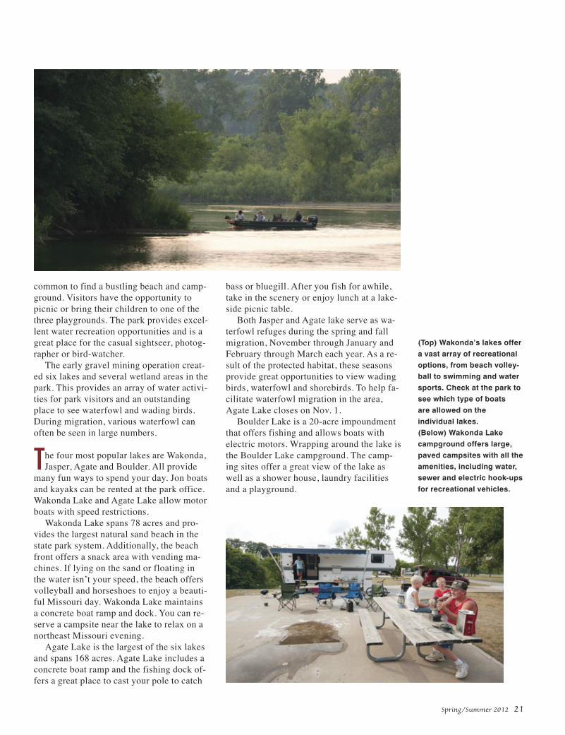
common to find a bustling beach and camp-ground. Visitors have the opportunity topicnic or bring their children to one of thethree playgrounds. The park provides excel-lent water recreation opportunities and is agreat place for the casual sightseer, photog-rapher or bird-watcher.
The early gravel mining operation creat-ed six lakes and several wetland areas in thepark. This provides an array of water activi-ties for park visitors and an outstandingplace to see waterfowl and wading birds.During migration, various waterfowl canoften be seen in large numbers.
The four most popular lakes are Wakonda,Jasper, Agate and Boulder. All provide
many fun ways to spend your day. Jon boatsand kayaks can be rented at the park office.Wakonda Lake and Agate Lake allow motorboats with speed restrictions.
Wakonda Lake spans 78 acres and pro-vides the largest natural sand beach in thestate park system. Additionally, the beachfront offers a snack area with vending ma-chines. If lying on the sand or floating inthe water isn’t your speed, the beach offersvolleyball and horseshoes to enjoy a beauti-ful Missouri day. Wakonda Lake maintainsa concrete boat ramp and dock. You can re-serve a campsite near the lake to relax on anortheast Missouri evening.
Agate Lake is the largest of the six lakesand spans 168 acres. Agate Lake includes aconcrete boat ramp and the fishing dock of-fers a great place to cast your pole to catch
bass or bluegill. After you fish for awhile,take in the scenery or enjoy lunch at a lake-side picnic table.
Both Jasper and Agate lake serve as wa-terfowl refuges during the spring and fallmigration, November through January andFebruary through March each year. As a re-sult of the protected habitat, these seasonsprovide great opportunities to view wadingbirds, waterfowl and shorebirds. To help fa-cilitate waterfowl migration in the area,Agate Lake closes on Nov. 1.
Boulder Lake is a 20-acre impoundmentthat offers fishing and allows boats withelectric motors. Wrapping around the lake isthe Boulder Lake campground. The camp-ing sites offer a great view of the lake aswell as a shower house, laundry facilitiesand a playground.
Spring/Summer 2012 21
(Top) Wakonda’s lakes offera vast array of recreationaloptions, from beach volley-ball to swimming and watersports. Check at the park tosee which type of boats are allowed on the individual lakes.(Below) Wakonda Lakecampground offers large,paved campsites with all theamenities, including water,sewer and electric hook-upsfor recreational vehicles.

22 Missouri Resources
Five biking and hiking trails are foundthroughout the park. These trails vary inlength from just under one-half mile to thelongest trail – three and one-half miles –which runs along the shore of Agate Lake.An additional one-mile trail leads throughthe sand prairie.
“Our location along the Highway 61 cor-ridor provides a great day-trip destination,as well as an excellent place to camp for afew nights,” said Scott.
The park offers a great array of recre-ational amenities, but it also offers a diversenatural setting to explore.
One highlight is its rare sand prairie. Thedredging activities that took place in the
early 1900s left behind man-made moundsof sand and gravel that were in close prox-imity to natural sand prairies along the Mis-sissippi River. Plants from those prairiescolonized the mounds, and even though theoriginal sand prairies have long since be-come farmland, the plants from them arepreserved as a special park feature.
Wakonda State Park is home to two suchsand prairies, which together encompass151 acres. Using special protection and pe-riodic prescribed burns, park staff havebeen able to preserve native MississippiRiver sand prairie plants including sanddropseed, Schweinitz’s flatsedge, eveningprimrose, cottongrass, flowering spurge and sandgrass.
They also have collected and addedseeds from other unique sand prairie speciesfound along nearby roads and field borders,thus adding plants such as hoary puccoon,lead plant, spotted bee balm, little bluestem,false sunflower, round-headed prairieclover and gray-headed coneflower. Thesetwo prairie preserves are great places toview both native prairie plants and grass-land birds.
In addition to the sand prairie, the park ishome to small wetlands, forest grasslandsand ponds that hold surprisingly diverse ar-rays of native plants, birds and wildlife. It’sespecially impressive in the spring and fallmigrations to find American white pelicans,geese, ducks, gulls, hawks and even baldeagles. Some wading birds such as blueherons and great egrets also can be ob-served and photographed.
“Wakonda State Park offers a great placeto explore nature, especially the rare sandprairie,” said Scott.
Wakonda State Park is located threemiles south of La Grange on State ParkRoad. For information about Wakonda StatePark, call the park at 573-655-2280 or visitmostateparks.com.
This story was a collaborative effort of stafffrom Missouri State Parks, a division of theMissouri Department of Natural Resources.
With its six lakes and 7.2miles of trails, Wakonda
State Park offers numerousavenues for visiting and en-
joying the peace and beauty of the outdoors.
“Wakonda State Park offers a great place to explore nature, especially
the rare sand prairie.”
– Kyle Scott, superintendent, Wakonda State Park.

In 1983 she was hired by the Department ofNatural Resources as a clerk typist, eventu-ally joining the staff at the EnvironmentalServices Program. This change marked aturning point. She began taking night class-es at Columbia College.
“I was surrounded by environmental spe-cialists, chemists and air quality staff,” saidZumalt. “I was so inspired by Cindy Daviesand Carrie Schulte because, while they wereworking as laboratory technicians, they alsostudied chemistry at Lincoln University. Ithought that is so interesting. I can do that!”
Schulte is now an environmental special-ist with the department’s Water PollutionControl Program, and Davies is the directorof the department’s Southwest Regional Of-fice in Springfield.
careerconnection
Terri Zumalt
by Victoria Lovejoyphotographs by Scott Myers
Spring/Summer 2012 23
R ed glowing lights, bubbling beakersand fluid dripping through tubes lie
behind the door marked, “Volatiles Lab,” atthe Missouri Department of Natural Re-sources’ Environmental Services Program.
The program’s Chemical Analysis Sec-tion staffs the state’s only environmentallaboratory. Each year, the section tests thou-sands of samples for volatiles, a class of or-ganic compounds which easily becomegaseous at room temperature. Somevolatiles are known or suspected carcino-gens. Volatile can also mean lively andlighthearted. Amid samples that are purgedby bubbling helium, laughter bubbles nowand then from chemist Terri Zumalt whenshe explains her work as one of severalchemists who analyze volatiles.
“One of the most important things is thatsamples have to be filled to the top so thereis no room for air,” Zumalt said, then
Lab Life is Testing
(Above) Chemist Terri Zumalt of the department’sEnvironmental ServicesProgram calibrates testingequipment before running samples.(Left) Water is distilled toobtain the purist fraction ofcontaminant-free, reagent-grade water.
chuckles. “We call that ‘free of head space.’Volatile compounds have low water solubil-ity and prefer to be in the form of a gas.”
Zumalt moved from pushing pizzas andpaper routes to pushing paper as an officesecretary with the Missouri Jaycees in 1982.

“I remember when Terri started workingat ESP many years ago, and I am so proudof her accomplishments,” Davies said. “It isextremely difficult to juggle work, schooland family but the flexibility shown by theESP in allowing adjusted work schedules toattend classes, and the encouragement thatdepartment staff provide to those trying toimprove themselves go a long way in mak-ing it possible.”
Working full time and juggling classeswas not easy but with the support of herhusband, Keith, who made grilled cheese ontest nights, Zumalt eventually graduatedmagna cum laude. She received her Bache-lor of Science in chemistry from LincolnUniversity in 2005.
Before transferring to the volatiles lab,Zumalt spent many years working behind adoor marked, “Organic Prep Lab,” and an-other door, “Organic Extractables Lab,”with Tarun Choudhury, Ph.D. She appreci-ated the encouragement that he providedwhile Choudhury found enjoyment in her“volatile” personality.
“It was a lot of fun working with Terri inthe organic labs,” Choudhury said. “Shewas very enthusiastic about learning newthings. When it came to learning, Terri Zu-malt was tireless.”
One instrument Zumalt mastered is thegas chromatograph mass spectrometer. Theinstrument is one of the tools used to identi-
fy and measure volatiles. Using this methodof analysis enables the laboratory to detectvolatiles at extremely low concentrations.
The Chemical Analysis Section providessupport for programs throughout the depart-ment and for other state agencies. Throughanalysis, section staff identify and confirmthe presence of natural and man-made pol-lutants. The section performed more than74,000 individual tests during fiscal year2011, which kept scientists in the lab mostof the time. Sharing lab space is easy, ac-cording to Doug Vogel, another volatiles labscientist. Vogel compares Zumalt to the un-sinkable Molly Brown.
“She is always up in spirit, nothing getsher down,” said Vogel. “I can depend on herto have a smile on her face. It’s nice to havecheerful company in the lab.”
Doing important work with people shecares about has obviously made Zumalthappy that her choices led her to see whatwas waiting behind the various laboratorydoors at the state environmental lab.
Visit dnr.mo.gov for information aboutthe Environmental Services Program andfor information about other career opportu-nities, visit the Office of Administration’swebsite: oa.mo.gov/pers/.
Victoria Lovejoy is a public informationspecialist in the department’s Environmen-tal Services Program.
24 Missouri Resources
Zumalt prepares a massspectrometer in the lab.Mass spectrometers are
used to identify chemicalcompounds based on their
fragmentation patterns.
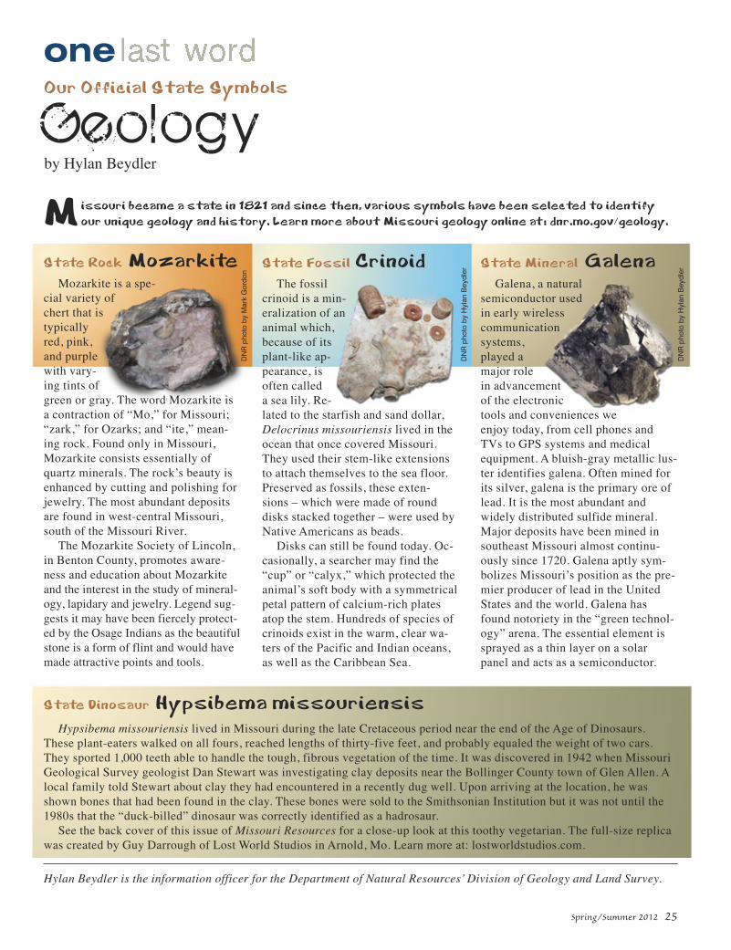
Spring/Summer 2012 25
one
State Rock MozarkiteMozarkite is a spe-
cial variety ofchert that istypicallyred, pink,and purplewith vary-ing tints ofgreen or gray. The word Mozarkite isa contraction of “Mo,” for Missouri;“zark,” for Ozarks; and “ite,” mean-ing rock. Found only in Missouri,Mozarkite consists essentially ofquartz minerals. The rock’s beauty isenhanced by cutting and polishing forjewelry. The most abundant depositsare found in west-central Missouri,south of the Missouri River.
The Mozarkite Society of Lincoln,in Benton County, promotes aware-ness and education about Mozarkiteand the interest in the study of mineral-ogy, lapidary and jewelry. Legend sug-gests it may have been fiercely protect-ed by the Osage Indians as the beautifulstone is a form of flint and would havemade attractive points and tools.
State Fossil CrinoidThe fossil
crinoid is a min-eralization of ananimal which,because of itsplant-like ap-pearance, isoften calleda sea lily. Re-lated to the starfish and sand dollar,Delocrinus missouriensis lived in theocean that once covered Missouri.They used their stem-like extensionsto attach themselves to the sea floor.Preserved as fossils, these exten-sions – which were made of rounddisks stacked together – were used byNative Americans as beads.
Disks can still be found today. Oc-casionally, a searcher may find the“cup” or “calyx,” which protected theanimal’s soft body with a symmetricalpetal pattern of calcium-rich platesatop the stem. Hundreds of species ofcrinoids exist in the warm, clear wa-ters of the Pacific and Indian oceans,as well as the Caribbean Sea.
State Mineral GalenaGalena, a natural
semiconductor usedin early wirelesscommunicationsystems,played amajor rolein advancementof the electronictools and conveniences weenjoy today, from cell phones andTVs to GPS systems and medicalequipment. A bluish-gray metallic lus-ter identifies galena. Often mined forits silver, galena is the primary ore oflead. It is the most abundant andwidely distributed sulfide mineral.Major deposits have been mined insoutheast Missouri almost continu-ously since 1720. Galena aptly sym-bolizes Missouri’s position as the pre-mier producer of lead in the UnitedStates and the world. Galena hasfound notoriety in the “green technol-ogy” arena. The essential element issprayed as a thin layer on a solarpanel and acts as a semiconductor.
Our Official State Symbols
Geologyby Hylan Beydler
State Dinosaur Hypsibema missouriensisHypsibema missouriensis lived in Missouri during the late Cretaceous period near the end of the Age of Dinosaurs.
These plant-eaters walked on all fours, reached lengths of thirty-five feet, and probably equaled the weight of two cars.They sported 1,000 teeth able to handle the tough, fibrous vegetation of the time. It was discovered in 1942 when MissouriGeological Survey geologist Dan Stewart was investigating clay deposits near the Bollinger County town of Glen Allen. Alocal family told Stewart about clay they had encountered in a recently dug well. Upon arriving at the location, he wasshown bones that had been found in the clay. These bones were sold to the Smithsonian Institution but it was not until the1980s that the “duck-billed” dinosaur was correctly identified as a hadrosaur.
See the back cover of this issue of Missouri Resources for a close-up look at this toothy vegetarian. The full-size replicawas created by Guy Darrough of Lost World Studios in Arnold, Mo. Learn more at: lostworldstudios.com.
Hylan Beydler is the information officer for the Department of Natural Resources’ Division of Geology and Land Survey.
Missouri became a state in 1821 and since then, various symbols have been selected to identifyour unique geology and history. Learn more about Missouri geology online at: dnr.mo.gov/geology.
DN
R p
hoto
by
Mar
k G
ordo
n
DN
R p
hoto
by
Hyl
an B
eydl
er
DN
R p
hoto
by
Hyl
an B
eydl
er

MISSOURI DEPARTMENT OF NATURAL RESOURCESPO Box 176Jefferson City, MO 65102-0176
Nonprofit Org.US POSTAGE PAID
MO Dept. ofNatural
Resources