Embed Size (px)
Citation preview
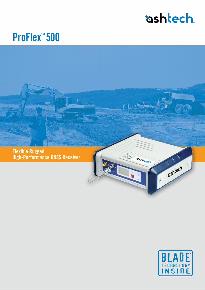
ProFlex™ 500
Flexible Rugged High-Performance GNSS Receiver
Its innovative design makes it the ideal solution for onboard system integration - it can be mounted easily on a machine or vehicle
for land or sea operations - and it is also a perfect back-pack rover or reference station solution for precise land surveying.
ProFlex 500 offers GPS+GLONASS+20 years of field-proven professional technologies. It is made to withstand harsh
environments, and gives you maximum flexibility in the field.
n Fast initialization and centimeter accuracy at long-rangen Unique BLADE technology for full benefit of any available GLONASS correctionsn Unique built-in communication featuresn Hot-Standby RTK feature for automatic best position availabilityn Rugged design for demanding work environmentsn Advanced multi-path mitigation and robust signal tracking for maximum data reliabilityn Interoperability with any vendor's reference station transmitting GPS+GLONASS L1/L2
High-End Performance
The ProFlex 500 with BLADE has the ability to provide the best possible measurements from three constellations
GPS+GLONASS+SBAS – one of the key differentiators offered by our BLADE technology. The receiver itself makes all the checks
and preparations needed to mitigate any negative effects of GLONASS signal instabilities. The result is more reliable measurement
processing and usage than with competing receiver offerings. Additionally, the ProFlex 500 can work with any other manufacturer’s
base or reference stations (VRS, FKP or MAC formats supported).
Ruggedness
The innovative design integrates all the communication components (GSM/GPRS and/or UHF radios) offering an all-in-one robust
solution to the user. The weatherproof, high-impact resistant molded aluminum housing ensures your investment is safe in all
conditions, which is especially important for onboard machine usage or base station applications.
Flexibility
The ProFlex 500 offers a unique design with various mounting
capabilities. It includes a unique set of built-in communication
options, internal and removable battery, internal memory, specific kits
per application and full compatibility with various software solutions such
as FAST Survey™, GNSS Solutions™ and Real Time Data Server (RTDS™).
Adaptable to most any specific positioning usage, the ProFlex 500 is
also the ideal solution for people looking for a single GNSS receiver for
multiple applications.
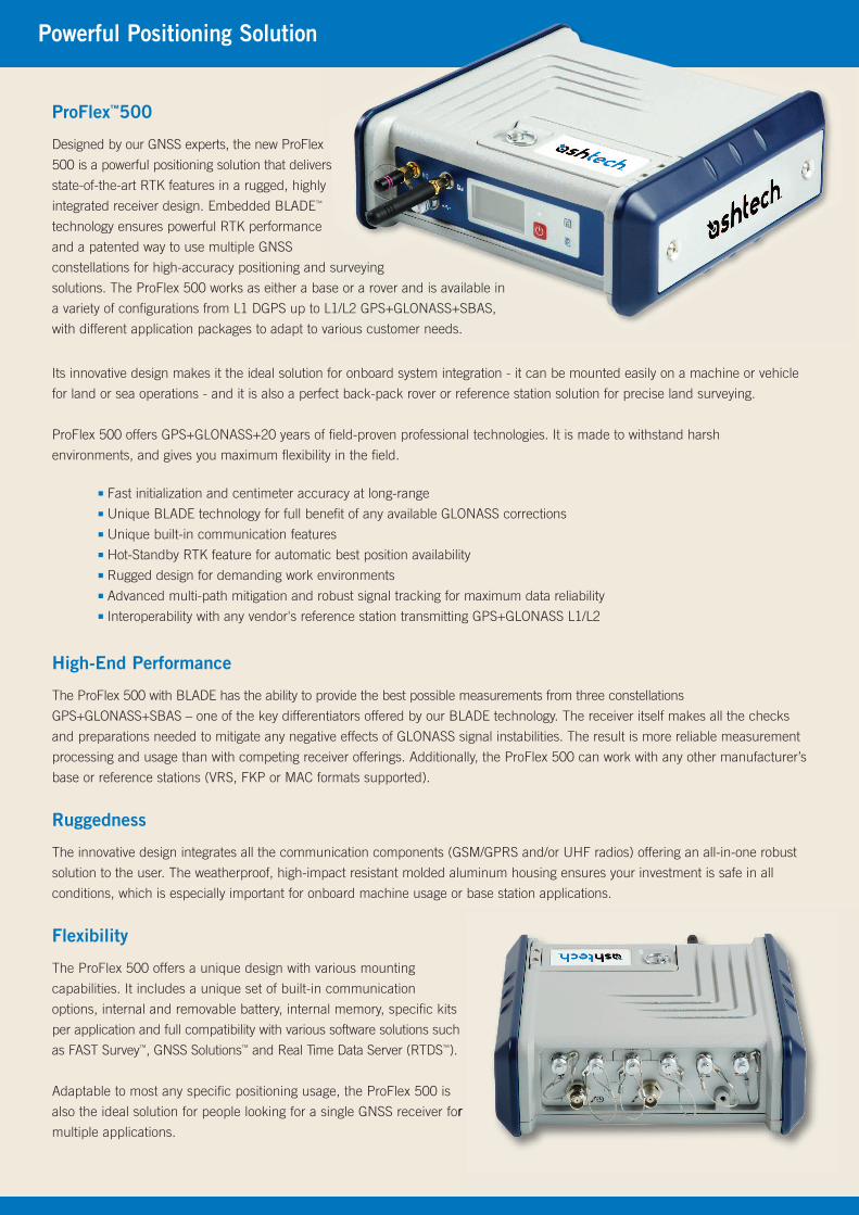
Powerful Positioning Solution
ProFlex™500
Designed by our GNSS experts, the new ProFlex
500 is a powerful positioning solution that delivers
state-of-the-art RTK features in a rugged, highly
integrated receiver design. Embedded BLADE™
technology ensures powerful RTK performance
and a patented way to use multiple GNSS
constellations for high-accuracy positioning and surveying
solutions. The ProFlex 500 works as either a base or a rover and is available in
a variety of configurations from L1 DGPS up to L1/L2 GPS+GLONASS+SBAS,
with different application packages to adapt to various customer needs.
Application Packages
Survey BackpackThis kit is the ideal package for using your ProFlex 500 in the field for surveying. Itincludes a robust and comfortable water-resistant backpack specifically designedfor ProFlex 500 and its accessories, a UHF pole and cable, a GPS cable with asmart quick-release system, a second Li-ion battery, a tape measure and our GNSSSolutions software for project and geoid management.
MarineGPS and UHF Marine Aerial Kits are available for the ProFlex 500 for easy andpowerful installation onboard ships. Specifically designed for coastal works,dredging, bathymetry or offshore user needs, it includes low-loss GPS or UHFcables (10 or 30 meters), UHF antenna and rugged mounting parts. Our BLADElong range RTK capability combined with our UHF expertise will allow you toincrease your productivity.
These application packages are detailed on our web site, please visit ashtech.com to download specific PDF documentation.
Base Station and Continuously Operating Reference StationWith its built-in Ethernet capability and embedded Web Server, you may accessyour ProFlex 500 from any computer connected to the Internet to control andmonitor your equipment.
With its capability for instant real-time multi-data streaming over Ethernet, you maybuild your own RTK corrections server without any additional software or equipment.It enables surveyors to have an efficient alternative to RTK networks (public orprivate) and also solve radio propagation issues, provided a GPRS cellular network is available.
ConnectivityIn addition to those already provided within the standard configuration, this kitincludes all the cables (serial cables, USB cable, 10m GPS cable, 10m UHFcable, power cable to connect on an external battery), and will allow you to alwaysfind the right set-up, and optimize the operational use of your receiver, either as arover, a base or onboard a vehicle.
Onboard Machine Integration
Ready for system integration, ProFlex 500 is a great GNSS solution alternative forOEM manufacturers and VARs who need precise positioning for the machineguidance/control markets, such as agriculture, construction or mining. Contact us tosee how you can fully benefit from our unique BLADE technology for your application.

Survey Solutions Contact Information:In USA +1 408 572 1103 n Fax +1 408 572 1199In South America +1 305 726 7813 Email [email protected]
In France +33 2 28 09 38 00 n Fax +33 2 28 09 39 39In Russia +7 495 980 5400 n Fax +7 495 981 4840Email [email protected]
In Singapore +65 9838 4229 n Fax +65 6777 9881In China +86 10 5802 5174 n Fax +86 10 5802 5135 Email [email protected]
Ashtech follows a policy of continuous product improvement; specifications and descriptions are thus subject to change without notice. Please contact Ashtech for the latest product information©2010 Ashtech LLC. All rights reserved. The Ashtech logo, BLADE and ProFlex are trademarks of Ashtech LLC. All other product and brand names are trademarks of their respective holders. Rev (May 2010)
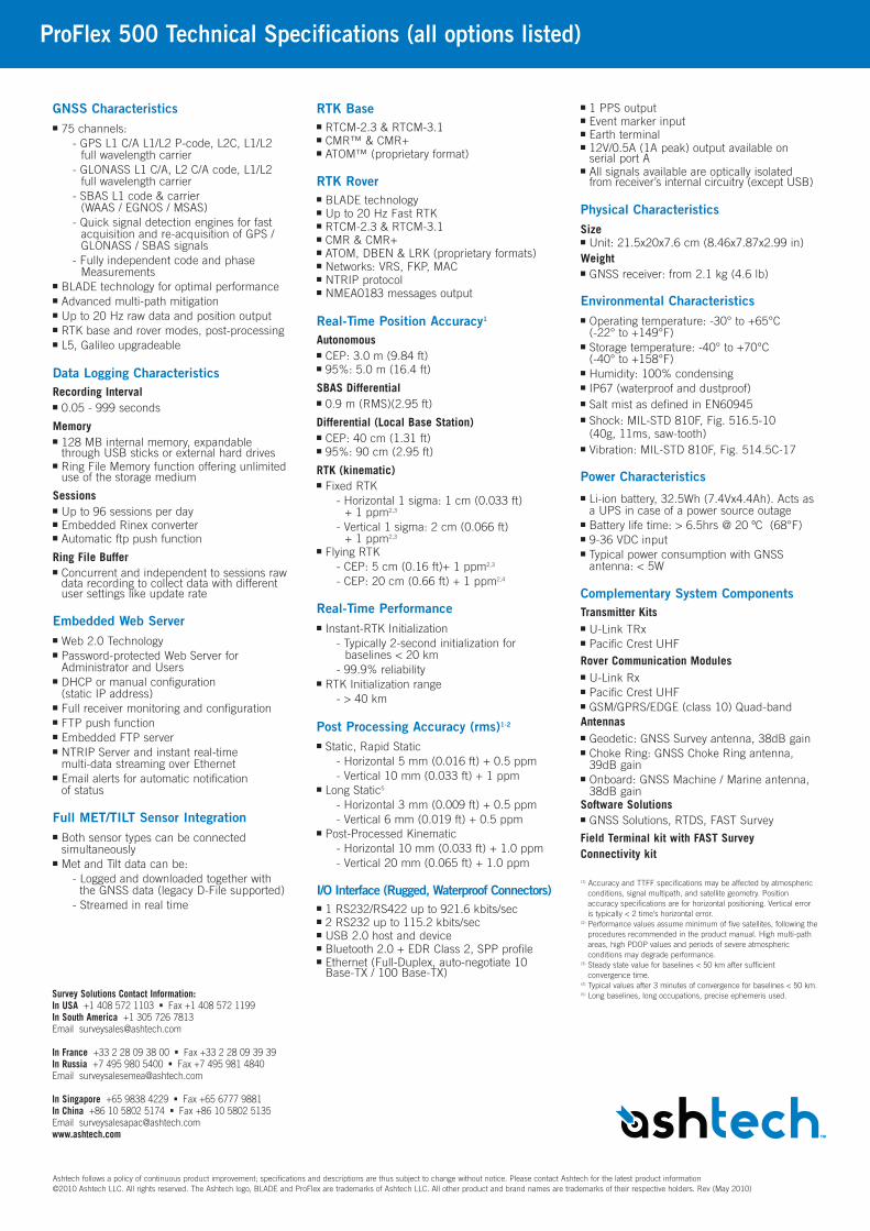
ProFlex 500 Technical Specifications (all options listed)
GNSS Characteristicsn 75 channels:
- GPS L1 C/A L1/L2 P-code, L2C, L1/L2 full wavelength carrier
- GLONASS L1 C/A, L2 C/A code, L1/L2 full wavelength carrier
- SBAS L1 code & carrier (WAAS / EGNOS / MSAS)
- Quick signal detection engines for fast acquisition and re-acquisition of GPS / GLONASS / SBAS signals
- Fully independent code and phase Measurements
n BLADE technology for optimal performancen Advanced multi-path mitigationn Up to 20 Hz raw data and position outputn RTK base and rover modes, post-processingn L5, Galileo upgradeable
Data Logging CharacteristicsRecording Intervaln 0.05 - 999 seconds
Memory n 128 MB internal memory, expandablethrough USB sticks or external hard drives
n Ring File Memory function offering unlimiteduse of the storage medium
Sessionsn Up to 96 sessions per dayn Embedded Rinex convertern Automatic ftp push function
Ring File Buffern Concurrent and independent to sessions rawdata recording to collect data with differentuser settings like update rate
Embedded Web Servern Web 2.0 Technologyn Password-protected Web Server forAdministrator and Users
n DHCP or manual configuration (static IP address)
n Full receiver monitoring and configurationn FTP push functionn Embedded FTP servern NTRIP Server and instant real-time multi-data streaming over Ethernet
n Email alerts for automatic notification of status
Full MET/TILT Sensor Integrationn Both sensor types can be connectedsimultaneously
n Met and Tilt data can be:- Logged and downloaded together with the GNSS data (legacy D-File supported)- Streamed in real time
RTK Basen RTCM-2.3 & RTCM-3.1n CMR™ & CMR+n ATOM™ (proprietary format)
RTK Rovern BLADE technologyn Up to 20 Hz Fast RTKn RTCM-2.3 & RTCM-3.1n CMR & CMR+n ATOM, DBEN & LRK (proprietary formats)n Networks: VRS, FKP, MACn NTRIP protocoln NMEA0183 messages output
Real-Time Position Accuracy1
Autonomousn CEP: 3.0 m (9.84 ft)n 95%: 5.0 m (16.4 ft)
SBAS Differentialn 0.9 m (RMS)(2.95 ft)
Differential (Local Base Station)n CEP: 40 cm (1.31 ft)n 95%: 90 cm (2.95 ft)
RTK (kinematic)n Fixed RTK
- Horizontal 1 sigma: 1 cm (0.033 ft) + 1 ppm2,3
- Vertical 1 sigma: 2 cm (0.066 ft) + 1 ppm2,3
n Flying RTK- CEP: 5 cm (0.16 ft)+ 1 ppm2,3
- CEP: 20 cm (0.66 ft) + 1 ppm2,4
Real-Time Performancen Instant-RTK Initialization
- Typically 2-second initialization for baselines < 20 km
- 99.9% reliabilityn RTK Initialization range
- > 40 km
Post Processing Accuracy (rms)1-2
n Static, Rapid Static- Horizontal 5 mm (0.016 ft) + 0.5 ppm- Vertical 10 mm (0.033 ft) + 1 ppm
n Long Static5
- Horizontal 3 mm (0.009 ft) + 0.5 ppm- Vertical 6 mm (0.019 ft) + 0.5 ppm
n Post-Processed Kinematic- Horizontal 10 mm (0.033 ft) + 1.0 ppm- Vertical 20 mm (0.065 ft) + 1.0 ppm
I/O Interface (Rugged, Waterproof Connectors)n 1 RS232/RS422 up to 921.6 kbits/secn 2 RS232 up to 115.2 kbits/secn USB 2.0 host and devicen Bluetooth 2.0 + EDR Class 2, SPP profilen Ethernet (Full-Duplex, auto-negotiate 10Base-TX / 100 Base-TX)
n 1 PPS outputn Event marker inputn Earth terminaln 12V/0.5A (1A peak) output available onserial port A
n All signals available are optically isolatedfrom receiver’s internal circuitry (except USB)
Physical CharacteristicsSizen Unit: 21.5x20x7.6 cm (8.46x7.87x2.99 in)Weightn GNSS receiver: from 2.1 kg (4.6 lb)
Environmental Characteristicsn Operating temperature: -30° to +65°C (-22° to +149°F)
n Storage temperature: -40° to +70°C (-40° to +158°F)
n Humidity: 100% condensingn IP67 (waterproof and dustproof)n Salt mist as defined in EN60945n Shock: MIL-STD 810F, Fig. 516.5-10 (40g, 11ms, saw-tooth)
n Vibration: MIL-STD 810F, Fig. 514.5C-17
Power Characteristicsn Li-ion battery, 32.5Wh (7.4Vx4.4Ah). Acts asa UPS in case of a power source outage
n Battery life time: > 6.5hrs @ 20 ºC (68°F)n 9-36 VDC inputn Typical power consumption with GNSSantenna: < 5W
Complementary System ComponentsTransmitter Kitsn U-Link TRxn Pacific Crest UHFRover Communication Modulesn U-Link Rxn Pacific Crest UHFn GSM/GPRS/EDGE (class 10) Quad-bandAntennasn Geodetic: GNSS Survey antenna, 38dB gainn Choke Ring: GNSS Choke Ring antenna,39dB gain
n Onboard: GNSS Machine / Marine antenna,38dB gain
Software Solutions n GNSS Solutions, RTDS, FAST Survey
Field Terminal kit with FAST SurveyConnectivity kit
(1) Accuracy and TTFF specifications may be affected by atmosphericconditions, signal multipath, and satellite geometry. Positionaccuracy specifications are for horizontal positioning. Vertical erroris typically < 2 time’s horizontal error.
(2) Performance values assume minimum of five satellites, following theprocedures recommended in the product manual. High multi-pathareas, high PDOP values and periods of severe atmosphericconditions may degrade performance.
(3) Steady state value for baselines < 50 km after sufficientconvergence time.
(4) Typical values after 3 minutes of convergence for baselines < 50 km.(5) Long baselines, long occupations, precise ephemeris used.