Embed Size (px)
Citation preview
MOBILE INDOOR LASER SCANNING FOR 3D STRATA
REGISTRATION PURPOSES BASED ON INDOORGML
Mohd Nizar Hashim1,2 , Muhammad Imzan Hassan1, Alias Abdul Rahman1
1 3D GIS Research lab, Faculty of Built Environment and Surveying, Universiti Teknologi Malaysia (UTM)
[email protected], [email protected], [email protected] 2 Politeknik Kuching Sarawak, km22, Jalan Matang, 93050, Kuching Sarawak. - [email protected]
KEY WORDS: 3D registration, 3D strata, 3D model
ABSTRACT:
In Malaysia, the current 2D cadastre system is regularly updated by the National Mapping Agency (NMA) and Land Offices (LO).
However, this 2D information may not be able to serve complex situations. The 3D strata acquisition and 3D modelling are
important for strata title to manage the Right, Restriction and Responsibility (RRRs). This means there is a need for the system to be
extended into 3D cadastre environment. One of the data acquisition techniques such as LiDAR from Mobile Laser Scanning (MLS)
could be utilised to solve the problem. This research also discusses the 3D geospatial objects generated from the captured point-
clouds, modelled in SketchUp and transformed into IndoorGML. In this study, Web application is developed as a platform for
generating an integrated XML-IndoorGML schema. Thus, this research contributes on 3D strata modelling especially for the
development of 3D strata registration in Malaysia.
1. INTRODUCTION
Strata Rapid development of a country created more spaces for
industrial and residential buildings land usages. This is
indirectly inspiring multilayer building (strata) especially for the
development of residential properties such as flat, apartments,
condominiums and others. Development of these strata unit is
related to strata title plans. This strata title process involves
many parties such as Pejabat Tanah Galian (PTG), Surveyors
and Jabatan Ukur dan Pemetaan Malaysia (JUPEM). Currently
development strata title is done in 3D and to support this
process 3D strata registration is proposed for future.
There are various advantages of using 3D strata registration
including good accessibility to the legal status of stratified
property, digital drawing storage of 3D representation (instead
of hard copy in document of title) and access of 3D spatial
information through unique parcel identifier of the surface
parcel (computerisation instead of manually search for the
associated hard copies), and enhancing to include the snapshots
of the property from the exterior and interior, or the panorama
images.
Strata title is an ownership designed for multi-level apartment
blocks and subdivisions with shared areas. As expressed in the
National Land Code (1965), the „strata‟ term refers to building
has multiple levels. Strata title was first presented in New South
Wales on 1961, to manage with authorised ownership of
building apartment blocks.
The urbanization has encouraging to the development and
transformation of pattern in property ownership. According to
Noh (2012), the demands of high buildings are increasing and
they have been built to offer different types of property tenure
other than landed property. The needs for strata title is growing
rapidly as the buildings with more than one floor where every
floor has many lots are built. It led to the beginning of a new
law which is the Strata Titles Act 1985 (STA).
Previously, Strata Titles Act 1985 formation of subdivision of
the building was provided in the National Land Code (NLC)
1965. There were cons and flaws discovered in the enactment
before in relations and terms of technical and also legal
requirements. Therefore a new, better and improved legal
structure is applied which finally leads to the STA.
STA 1985 is an act to assist the subdivision of buildings in lots
or parcels. This act is made of a few applications such as
registration, subdivision, and issuance of strata title outline as
known as “Strata Title Board”. The STA is under the
supervision of the Federal Department of Land and Mines
(JKPTG) which is under the Ministry of Water, Land and
Natural Resources Malaysia (KATS). STA was implemented
and enforced starting June, 1985. All types of title applications
for the high-rise buildings parcel can be made under the
provisions of NLC 1965 before this act was held.
Section 2 discusses on problem statement. Methodology discuss
in section 3. Section 4 describes the integrated XML-
IndoorGml. Conclusion and future work will be discussed in
section 5.
2. PROBLEM STATEMENT
The idea of having 3D database for the cadastral system has
been discussed and elaborated for a good and efficient
management in Malaysia (Hassan, 2017). As reported by Stoter
and Oosterom (2006), the 3D development was approach in
other domains such as 3D GIS (Geographical Information
Systems) and it will make a 3D cadastral realisable. In
Malaysia, the current 2D cadastre system is commonly updated
by the National Mapping Agency (NMA), i.e. the Department
of Survey and Mapping Malaysia (JUPEM). However, this 2D
information may not be able to serve complex situations. Thus,
there is a need for the system to be extended into 3D cadastre
environment.
The International Archives of the Photogrammetry, Remote Sensing and Spatial Information Sciences, Volume XLII-4/W16, 2019 6th International Conference on Geomatics and Geospatial Technology (GGT 2019), 1–3 October 2019, Kuala Lumpur, Malaysia
This contribution has been peer-reviewed. https://doi.org/10.5194/isprs-archives-XLII-4-W16-241-2019 | © Authors 2019. CC BY 4.0 License.
241
The authority utilises traditional technique and other existing
floor plans for strata modelling (Isa et al., 2018). However, the
existing technique (i.e. traditional building survey) is laborious
and time consuming for 3D objects modelling purposes. Other
than that, it is difficult to get a proper floor plan depending on
the building age (old and existing building), developers, local
authorities and others (Hashim et al., 2018). One of the methods
is to use Light Detection And Ranging (LiDAR) data to solve
the problem.
LiDAR data has been captured and used in various places
including in Malaysia. This data has been collected by national
and private data providers for various mapping tasks including
3D city modelling, 3D cadastre and strata (Buyuksalih and
Bayburt, 2017; Abdul-Rahman, 2016). The data offers several
advantages especially its high accuracy despite the high costs
and huge data volume. The 3D geospatial objects could be
produced from the captured point-clouds and there are many
work been initiated by the related agencies for 3D
geoinformation. The national mapping agency tries to make use
of LiDAR datasets (airborne and terrestrial) for 3D cadastre and
recently the authority has deployed indoor laser scanning
technique for strata purposes. Therefore, this piece of work
suggest to utilise one of the indoor modelling standards, namely
IndoorGML for representing 3D indoor features.
IndoorGML has been discussed much at international level.
This review includes multi-storey buildings as well as
condominiums (Tekavec and Lisec, 2018). With Extensible
Markup Language (XML) based data formats (Ilku and Tamas,
2018), this model needs to fit with the existing framework in
Malaysia. According to Alattas et al (2018), since XML is a
data exchange format which is widely used in the Web, an
application with generating database should be developed to
support the integrated IndoorGML data. On the other hand, the
indoor laser scanned data could be utilised for 3D strata
modelling, thus it forms major experiment in this research. The
research also attempts to explore the aspect of accuracy of the
generated rooms geometry and intends to briefly incorporate the
3D strata model and 3D strata registration.
3. METHODOLOGY
This research is divided into five main phases. Figure 1 shows
the general flows of the methodology and started with phase of
preliminary study which includes planning, literature review,
state the aims, state the objectives and scope.
Figure 1. General flows of the methodology
Phase 2 involves data acquisition while Phase 3 involves the
point-clouds processing, 3D modelling, IndoorGML and the
development of the web base. Phase 4 describes the design
integrated XML-IndoorGML and result and analysis will be
discussed in phase 5.
3.1 Data acquisition
Based on the preliminary study, there are two types of data
needed to be accomplished in this research. The current
development of 3D strata model and the current standard XML
are required for this study. Figures 2 show the data acquisition
techniques for this study.
Figure 2. Data acquisition techniques
JUPEM has been providing the data point-clouds using TLS
and MLS. The data provided are data for floor level 9 and 10 of
their building at Jalan Semarak. For TLS the data was captured
by Topcon - C10 while MLS is using Reigl product. Besides,
several series of interview have been carried out for further
explanation on the problems and the system used by JUPEM.
3.2 Point Cloud Processing
Terrestrial Laser Scanning (TLS) data provides images and
points cloud. This data is processed using the Cyclone and
SketchUp software. In Cyclone point-clouds data must be
registered, then a model space is created and filtered before
converting it into suitable format such as *.las, *.ptx, *.pts and
others.
Figure 3. Flows of the processing point-clouds
Register point-clouds is also known as point matching (use
target on ground as a reference point), is the process of finding
a spatial transformation that aligns two or more point set. The
purpose of registration is to merge multiple data sets into one
model space and readily to filter. Filtering process is to extract
feature from raw point-clouds dataset. After filtering is
completed, point-clouds data will be converted into *.pts
format.
The International Archives of the Photogrammetry, Remote Sensing and Spatial Information Sciences, Volume XLII-4/W16, 2019 6th International Conference on Geomatics and Geospatial Technology (GGT 2019), 1–3 October 2019, Kuala Lumpur, Malaysia
This contribution has been peer-reviewed. https://doi.org/10.5194/isprs-archives-XLII-4-W16-241-2019 | © Authors 2019. CC BY 4.0 License.
242
3.3 3D modelling process
LiDAR data processing requires high-end computing
specifications due to a huge number of data volume (point-
clouds). Figure 4 shows the flow method from point-clouds to
3D modelling processes. One of the tools for TLS data
processing is Cyclone (from Leica). On the other hand, QT
Modeler is meant for MLS datasets. Then, the data in *.pts
format could be transferred for 3D modelling task e.g. using
SketchUp tool.
Figure 4. Simplified Method from point-clouds to 3D
Modelling
SketchUp software has been utilized to digitize the model. In
SketchUp (with undet plugin), data is opened and processed.
Using the suitable tools to start digitizing and to insert some
colours or textures for the building is important. Figure 5 shows
the transformation with digitizing from point-clouds to 3D
model.
Figure 5. Point-clouds to 3D model
The 3D model developed by Indoor MLS shape shows more
details with the showing of the edge at every angle compared to
the TLS 3D model. This is one of the advantages using indoor
MLS because the operator is moves and coverage angle to
collect the features is wider.
3.4 IndoorGML
The 3D data is exported such as *.dat or GML (using FME
software) to view in Java Indoor Editor (JIneditor) software. To
use JIneditor there are several requirements needed such as
using maven and java development kit. After some editing such
as inserting state and transitioning, the data will be exported
into IndoorGML.
3.5 Web-based Design
Web based is developed as a medium for the registration of data
attribute and 3D model. Thus, the design will be a framework
for standard XML-IndoorGML. There are two stages for
developing web-based; designing user interface and designing a
database.
3.5.1 User Interface (UI) Design
User interface (UI) is a front page for the communication
between user and the system. Designing the user interface will
be more efficient with a simple concept for data entry. Thus,
with HTML coding the designing is used for this purpose.
There are several parts or information for data entry needed to
be highlighted such as strata file, developer, share unit,
accessories and others. This is important as a current
requirement registration and the design also includes the 3D
model as a file for submission to JUPEM.
In other part, „Search‟ button is created for query function to
find the 3D model. This query is based on the Unique Feature
Identifier (UFI) as a primary key in a database.
Designing UI also prepares a space for IndoorGML viewer.
Here, the user will use this function to check the model before
uploading and submitting.
3.5.2 Database Design
Database design is a back end to the web pages which is to store
the data and input from user. The database uses MySQL and
PHPMyAdmin as a medium between database and webpages.
Database conceptual design uses UML for identifying the
structured data. Figure 6 shows the UML for the strata
purposes. This design states three superclass i.e. block, unit and
indoor model. To add, each superclass has the attribute with the
data type structure.
Figure 6. UML conceptual design and data structure.
Conceptual design with UML
and designing structure with
PHPMyAdmin
The International Archives of the Photogrammetry, Remote Sensing and Spatial Information Sciences, Volume XLII-4/W16, 2019 6th International Conference on Geomatics and Geospatial Technology (GGT 2019), 1–3 October 2019, Kuala Lumpur, Malaysia
This contribution has been peer-reviewed. https://doi.org/10.5194/isprs-archives-XLII-4-W16-241-2019 | © Authors 2019. CC BY 4.0 License.
243
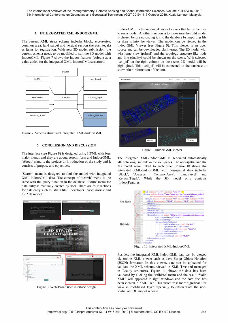
4. INTERGRATED XML-INDOORGML
The current XML strata schema includes block, accessories,
common area, land parcel and vertical section (keratan_tegak)
as items for registration. With new 3D model submission, the
current schema needs to be modified to suit the 3D model with
IndoorGML. Figure 7 shows the indoor features (colour) as a
value added for the integrated XML-IndoorGML structured.
Figure 7. Schema structured integrated XML-IndoorGML
5. CONCLUSION AND DISCUSSION
The interface (see Figure 8) is designed using HTML with four
major menus and they are about, search, form and IndoorGML.
„About‟ menu is the preface or introduction of the study and it
consists of purpose and objectives.
„Search‟ menu is designed to find the model with integrated
XML-IndoorGML data. The concept of „search‟ menu is the
same with the query function in the database. „Form‟ menu for
data entry is manually created by user. There are four sections
for data entry such as „strata file‟, „developer‟, „accessories‟ and
the „3D model‟.
Figure 8. Web-Based user interface design
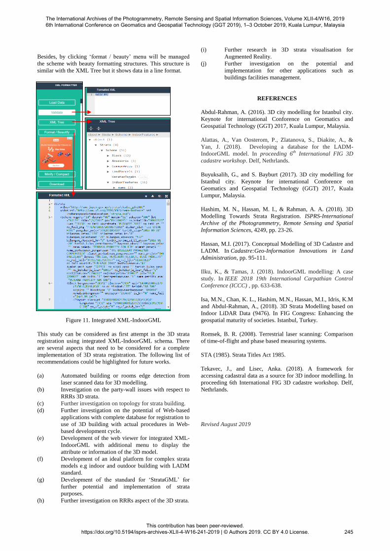
„IndoorGML‟ is the indoor 3D model viewer that helps the user
to see a model. Another function is to make sure the right model
is chosen before uploading it into the database by importing file
or drag it into the viewer. The model can be viewed in the
IndoorGML Viewer (see Figure 9). This viewer is an open
source and can be downloaded via internet. The 3D model with
wireframe view (primal) and the topology structure like node
and line (duality) could be shown on the scene. With selected
„cell_id‟ on the right column on the scene, 3D model will be
highlighted. This „cell_id‟ will be connected to the database to
show other information of the unit.
Figure 9. IndoorGML viewer
The integrated XML-IndoorGML is generated automatically
after clicking „submit‟ in the web pages. The non-spatial and the
3D model were linked to each other. Figure 10 shows the
integrated XML-IndoorGML with non-spatial data includes
„Block‟, „Aksesori‟, „CommonArea‟, „LandParcel‟ and
„KeratanTegak‟. While the 3D model only contains
„IndoorFeatures‟.
Figure 10. Integrated XML-IndoorGML
Besides, the integrated XML-IndoorGML data can be viewed
via online XML viewer such as Java Script Object Notation
(JSON) formatter. In this viewer, data can be uploaded for
validate the XML scheme, viewed in XML Tree and managed
in Beauty structures. Figure 11 shows the data has been
validated by clicking the „validate‟ menu and the result „Valid
XML‟ will appeared in right windows and the data also has
been viewed in XML Tree. This structure is more significant for
view in root-based layer especially to differentiate the non-
spatial and 3D model scheme.
IndoorGML viewer
The International Archives of the Photogrammetry, Remote Sensing and Spatial Information Sciences, Volume XLII-4/W16, 2019 6th International Conference on Geomatics and Geospatial Technology (GGT 2019), 1–3 October 2019, Kuala Lumpur, Malaysia
This contribution has been peer-reviewed. https://doi.org/10.5194/isprs-archives-XLII-4-W16-241-2019 | © Authors 2019. CC BY 4.0 License.
244
Besides, by clicking „format / beauty‟ menu will be managed
the scheme with beauty formatting structures. This structure is
similar with the XML Tree but it shows data in a line format.
Figure 11. Integrated XML-IndoorGML
This study can be considered as first attempt in the 3D strata
registration using integrated XML-IndoorGML schema. There
are several aspects that need to be considered for a complete
implementation of 3D strata registration. The following list of
recommendations could be highlighted for future works.
(a) Automated building or rooms edge detection from
laser scanned data for 3D modelling.
(b) Investigation on the party-wall issues with respect to
RRRs 3D strata.
(c) Further investigation on topology for strata building.
(d) Further investigation on the potential of Web-based
applications with complete database for registration to
use of 3D building with actual procedures in Web-
based development cycle.
(e) Development of the web viewer for integrated XML-
IndoorGML with additional menu to display the
attribute or information of the 3D model.
(f) Development of an ideal platform for complex strata
models e.g indoor and outdoor building with LADM
standard.
(g) Development of the standard for „StrataGML‟ for
further potential and implementation of strata
purposes.
(h) Further investigation on RRRs aspect of the 3D strata.
(i) Further research in 3D strata visualisation for
Augmented Reality.
(j) Further investigation on the potential and
implementation for other applications such as
buildings facilities management.
REFERENCES
Abdul-Rahman, A. (2016). 3D city modelling for Istanbul city.
Keynote for international Conforence on Geomatics and
Geospatial Technology (GGT) 2017, Kuala Lumpur, Malaysia.
Alattas, A., Van Oosterom, P., Zlatanova, S., Diakite, A., &
Yan, J. (2018). Developing a database for the LADM-
IndoorGML model. In proceeding 6th International FIG 3D
cadastre workshop. Delf, Nethrlands.
Buyuksalih, G., and S. Bayburt (2017). 3D city modelling for
Istanbul city. Keynote for international Conforence on
Geomatics and Geospatial Technology (GGT) 2017, Kuala
Lumpur, Malaysia.
Hashim, M. N., Hassan, M. I., & Rahman, A. A. (2018). 3D
Modelling Towards Strata Registration. ISPRS-International
Archive of the Photogrammetry, Remote Sensing and Spatial
Information Sciences, 4249, pp. 23-26.
Hassan, M.I. (2017). Conceptual Modelling of 3D Cadastre and
LADM. In Cadastre:Geo-Information Innovations in Land
Administration, pp. 95-111.
Ilku, K., & Tamas, J. (2018). IndoorGML modelling: A case
study. In IEEE 2018 19th International Carpathian Control
Conference (ICCC) , pp. 633-638.
Isa, M.N., Chan, K. L., Hashim, M.N., Hassan, M.I., Idris, K.M
and Abdul-Rahman, A., (2018). 3D Strata Modelling based on
Indoor LiDAR Data (9476). In FIG Congress: Enhancing the
geospatial maturity of societies. Istanbul, Turkey.
Romsek, B. R. (2008). Terrestrial laser scanning: Comparison
of time-of-flight and phase based measuring systems.
STA (1985). Strata Titles Act 1985.
Tekavec, J., and Lisec, Anka. (2018). A framework for
accessing cadastral data as a source for 3D indoor modelling. In
proceeding 6th International FIG 3D cadastre workshop. Delf,
Nethrlands.
Revised August 2019
The International Archives of the Photogrammetry, Remote Sensing and Spatial Information Sciences, Volume XLII-4/W16, 2019 6th International Conference on Geomatics and Geospatial Technology (GGT 2019), 1–3 October 2019, Kuala Lumpur, Malaysia
This contribution has been peer-reviewed. https://doi.org/10.5194/isprs-archives-XLII-4-W16-241-2019 | © Authors 2019. CC BY 4.0 License.
245


![BC Strata Property Act - bazingahelp.zendesk.com · STRATA PROPERTY ACT [SBC 1998] ... 78 Acquisition of land by strata corporation ... Part 15 — Strata Plan Amendment and Amalgamation](https://img.pdfslide.net/doc/110x75/5b1695857f8b9a596d8cce51/bc-strata-property-act-strata-property-act-sbc-1998-78-acquisition-of.jpg)


![Strata Schemes Management Regulation 2016€¦ · Strata Schemes Management Regulation 2016 [NSW] Part 2 Owners corporations and strata committees Part 2 Owners corporations and strata](https://img.pdfslide.net/doc/110x75/5ea65b07c6140324195ce6bc/strata-schemes-management-regulation-2016-strata-schemes-management-regulation-2016.jpg)