Embed Size (px)
Citation preview

ITU Kaleidoscope 2016ICTs for a Sustainable World
MOBILE SIGNAL EXTENSION IN DEEP SEA – TOWARDS A SAFE AND
SUSTAINABLE FISHERIES
Dineshkumar Singh, Sanjay KimbahuneInnovation Lab – Mumbai,
Tata Consultancy Services [email protected], [email protected] Bangkok, Thailand
14-16 November 2016
Fisheries in India and Associated Risks
• Fisheries sector contributes 0.83% to the Indian GDP.
• It supports rural economy in 3202 coastal villages.
• Provides livelihood to 0.9 Million full time fishermenand another 3.5 million in the processing andmarketing sector.
• 61% population is below poverty line, with annualearnings less than Rs 25,000 (US$400).
• Male person is usually the primary bread-winner(going on the boat). Hence his safety is of utmostimportance for well-being of family.
• Wind speed, direction, wave height and swells canbecome dangerous, which increases the vulnerability
for those at sea.
Bangkok, Thailand, 14-16 November 2016ITU Kaleidoscope 2016 - ICTs for a Sustainable World
Fisheries in India and Associated Risks
• During 1891 to 2000, 308 cyclones have hit thecoastal population, endangering the lives of 370million within the 100kms off the coast.
• Indian National Centre for Ocean Information Services(INCOIS) generates Potential Fishing Zone (PFZ) andOcean State Forecast (OSF) Advisories (fig. 1) forIndian coastal region.
• It processes the Chlorophyll and TSM images receivedfrom Oceansat-2 and Sea Surface Temperature (SST)images from NOAA-18/19 and MetOp-A/B satellites.
• These images are further processed for geometriccorrection, filtering and are geo-coded.
Bangkok, Thailand, 14-16 November 2016ITU Kaleidoscope 2016 - ICTs for a Sustainable World
Ocean State Forecast
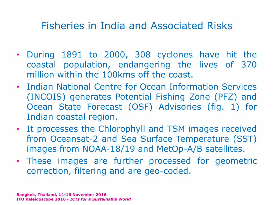
• OSF services display the temporal and spatial aspectsof the sea using Wind Speed and Direction, Swells andWave height parameter images.
• Images indicate the regions of sea in different coloursi.e. intensity of the wind speed or wave height.
• Higher the intensity, the more dangerous the zone willbe. Hence, availability of this information in advancehelps fishermen to get an idea of the state of theocean at any given point of time and forms the basisof the Early Warning System (EWS).
Bangkok, Thailand, 14-16 November 2016ITU Kaleidoscope 2016 - ICTs for a Sustainable World
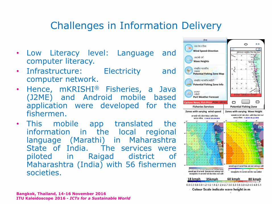
Challenges in Information Delivery
• Low Literacy level: Language andcomputer literacy.
• Infrastructure: Electricity andcomputer network.
• Hence, mKRISHI® Fisheries, a Java(J2ME) and Android mobile basedapplication were developed for thefishermen.
• This mobile app translated theinformation in the local regionallanguage (Marathi) in MaharashtraState of India. The services werepiloted in Raigad district ofMaharashtra (India) with 56 fishermensocieties.
Bangkok, Thailand, 14-16 November 2016ITU Kaleidoscope 2016 - ICTs for a Sustainable World
Wind Speed-Direction
Wave Heights
Potential Fishing Zone Map
Potential Fishing Zone Info
Port Weather Forecast
Cyclone News, Fish Price …
Fisheries Services Potential Fishing Zone
Zones with varying wind speed Zones with varying Wave Height
18 kmph 80 kmph35kmph 60 kmph
Benefits
• Advance information helped fisher to identify the PFZlocation, estimate the trip duration, and accordinglybudget the fuel, ice and labour requirement.
• Wind speed image helped them in finding out theareas where sea is calm and where it is turbulent.
• This brought more discipline in the trip planning andrisk assurance, leading to savings in diesel, cost andlife. Planning the boat cruise, in the direction of thewind, reduced the drag on the boat and henceimproved the diesel efficiency.
• This further resulted in the saving of fuel. Pre-planning can help save diesel, reduction in CO2emission and cost of catch too. This can make thefishing safer and sustainable
Bangkok, Thailand, 14-16 November 2016ITU Kaleidoscope 2016 - ICTs for a Sustainable World
It is still not enough …
• Fishermen complained that the information could notbe updated while they were at deep sea.
• This was especially true for the multi-day trawlersgoing for up to 10 to 15 days of fishing trip.
• The mobile service network was available only up to5-8 kms in the sea and hence, it was difficult for themto get the latest information while they were away inthe deep sea.
• This effectively reduced the utility of the EWS system.
• Extended mobile network in sea can help replan theirroute or go towards a calmer area in the deep sea.
• Research on the extension of the wireless signal(preferred mobility) in deep sea.
Bangkok, Thailand, 14-16 November 2016ITU Kaleidoscope 2016 - ICTs for a Sustainable World
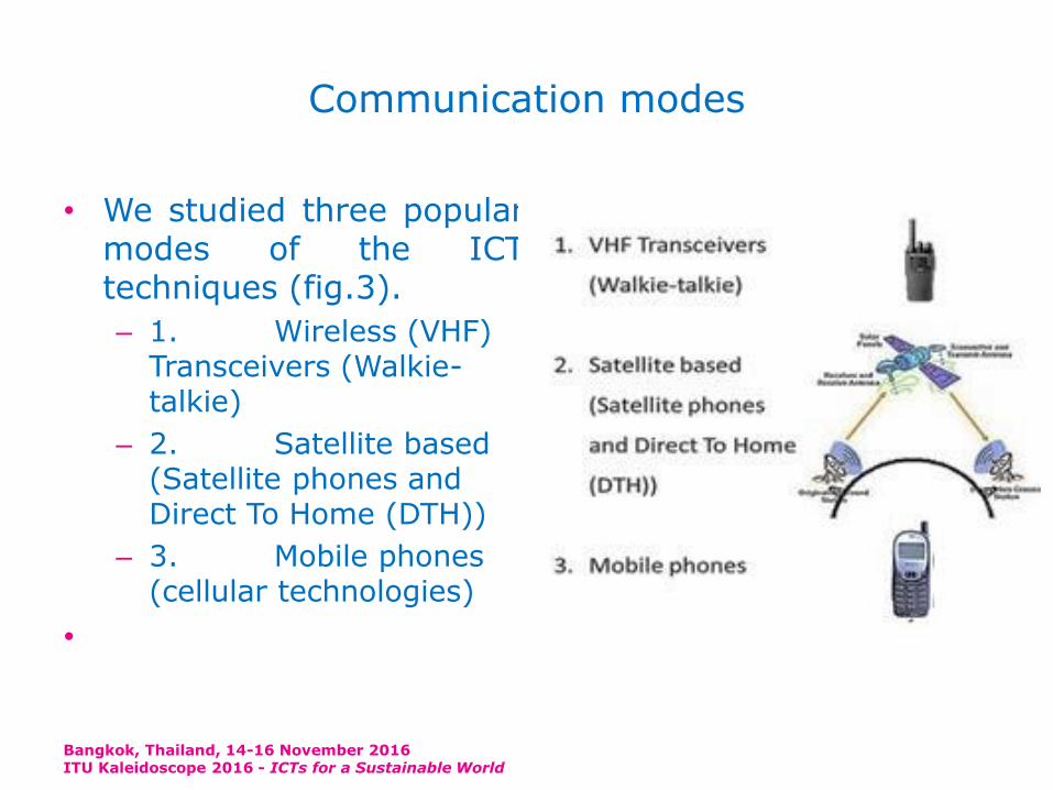
Communication modes
• We studied three popularmodes of the ICTtechniques (fig.3).
– 1. Wireless (VHF) Transceivers (Walkie-talkie)
– 2. Satellite based (Satellite phones and Direct To Home (DTH))
– 3. Mobile phones (cellular technologies)
•
Bangkok, Thailand, 14-16 November 2016ITU Kaleidoscope 2016 - ICTs for a Sustainable World
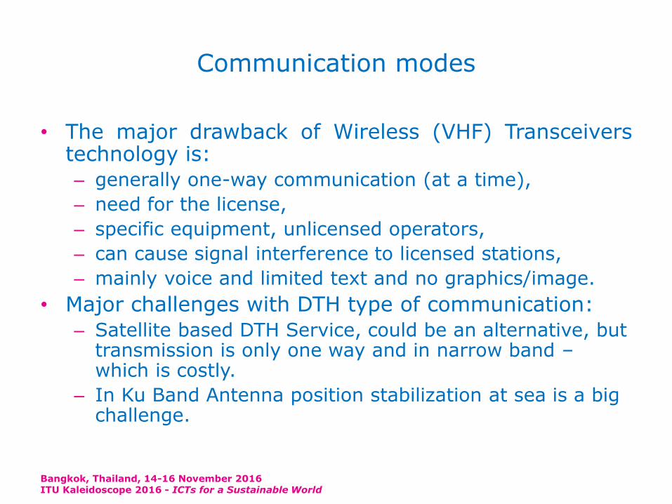
Communication modes
• The major drawback of Wireless (VHF) Transceiverstechnology is:
– generally one-way communication (at a time),
– need for the license,
– specific equipment, unlicensed operators,
– can cause signal interference to licensed stations,
– mainly voice and limited text and no graphics/image.
• Major challenges with DTH type of communication:
– Satellite based DTH Service, could be an alternative, but transmission is only one way and in narrow band –which is costly.
– In Ku Band Antenna position stabilization at sea is a big challenge.
Bangkok, Thailand, 14-16 November 2016ITU Kaleidoscope 2016 - ICTs for a Sustainable World
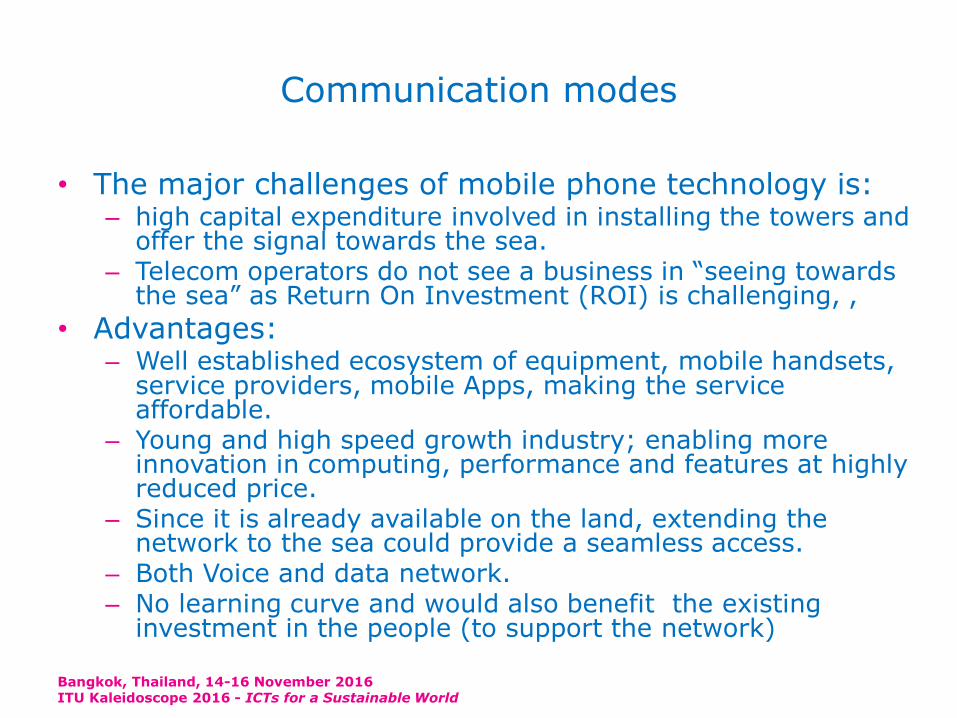
Communication modes
• The major challenges of mobile phone technology is:– high capital expenditure involved in installing the towers and
offer the signal towards the sea. – Telecom operators do not see a business in “seeing towards
the sea” as Return On Investment (ROI) is challenging, ,
• Advantages:– Well established ecosystem of equipment, mobile handsets,
service providers, mobile Apps, making the service affordable.
– Young and high speed growth industry; enabling more innovation in computing, performance and features at highly reduced price.
– Since it is already available on the land, extending the network to the sea could provide a seamless access.
– Both Voice and data network.– No learning curve and would also benefit the existing
investment in the people (to support the network)
Bangkok, Thailand, 14-16 November 2016ITU Kaleidoscope 2016 - ICTs for a Sustainable World

Mobile Signal Extension in Deep Sea – Pilot
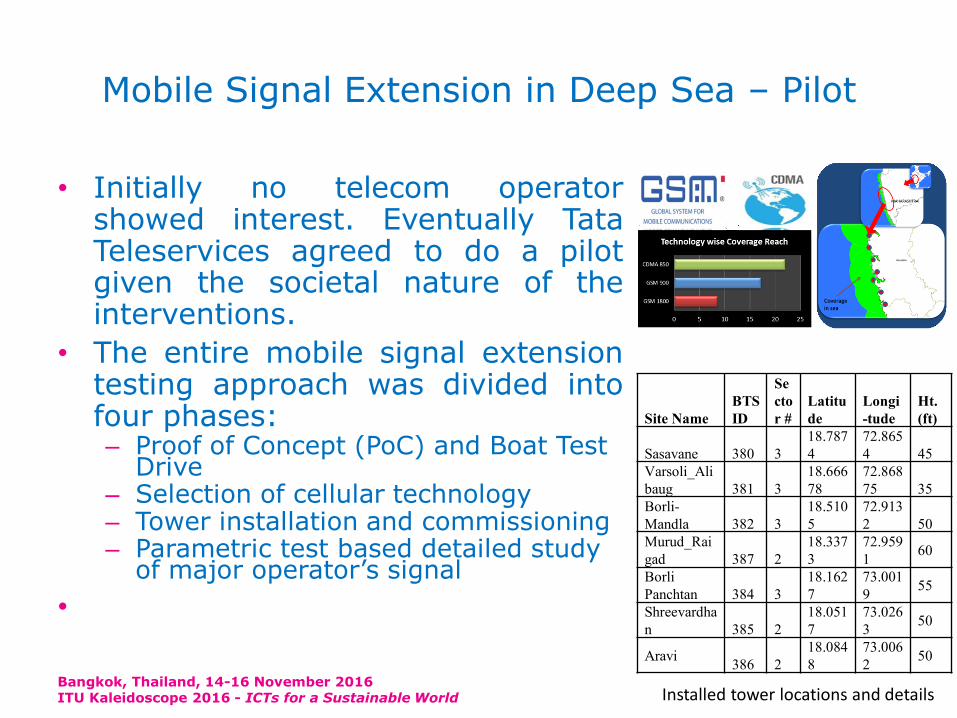
• Initially no telecom operator showed interest.Eventually Tata Teleservices Ltd. (TTL) agreed to do apilot given the societal nature of the interventions.
• The entire mobile signal extension testing approachwas divided into four phases:– Proof of Concept (PoC) and Boat Test Drive– Selection of cellular technology– Tower installation and commissioning– Parametric test based detailed study of major operator’s
signal
•
Bangkok, Thailand, 14-16 November 2016ITU Kaleidoscope 2016 - ICTs for a Sustainable World
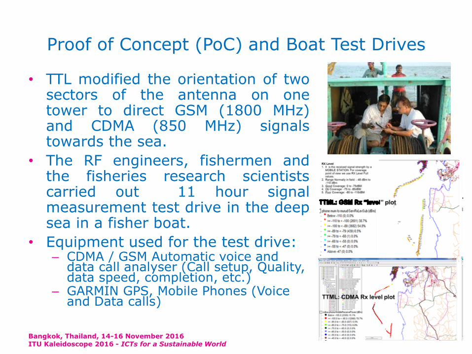
Proof of Concept (PoC) and Boat Test Drives
• TTL modified the orientation of twosectors of the antenna on onetower to direct GSM (1800 MHz)and CDMA (850 MHz) signalstowards the sea.
• The RF engineers, fishermen andthe fisheries research scientistscarried out 11 hour signalmeasurement test drive in the deepsea in a fisher boat.
• Equipment used for the test drive:– CDMA / GSM Automatic voice and
data call analyser (Call setup, Quality, data speed, completion, etc.)
– GARMIN GPS, Mobile Phones (Voice and Data calls)
Bangkok, Thailand, 14-16 November 2016ITU Kaleidoscope 2016 - ICTs for a Sustainable World

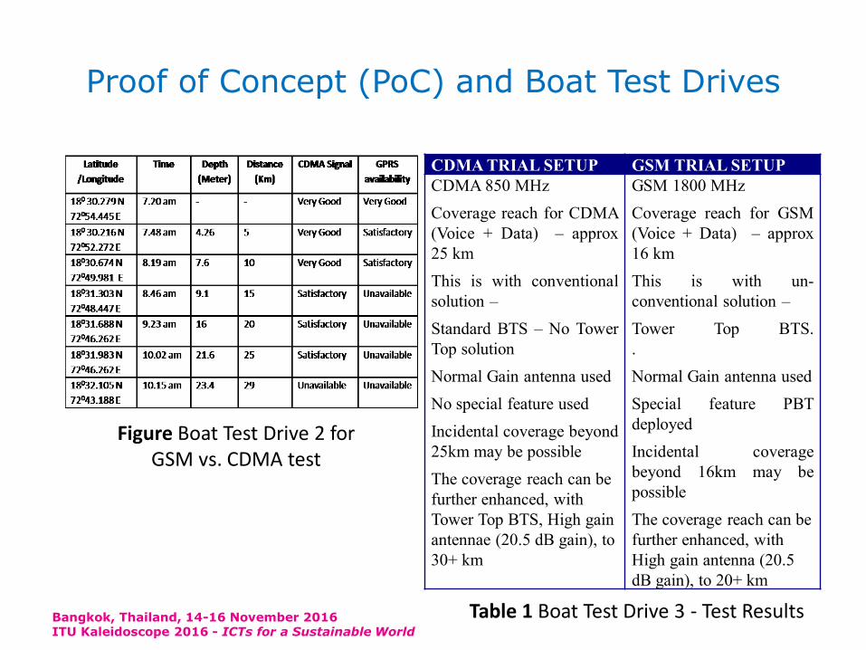
Proof of Concept (PoC) and Boat Test Drives
• Boat Test Drive 2 – GSM and CDMA comparison:
– the line of sight is a major limitation (25-30 KM) because of the earth curvature.
– adjusted the power level, height and the direction of the antennas at two different locations (towers). This helped to narrow down the testing parameters such as technology, frequency band, tower height, etc.
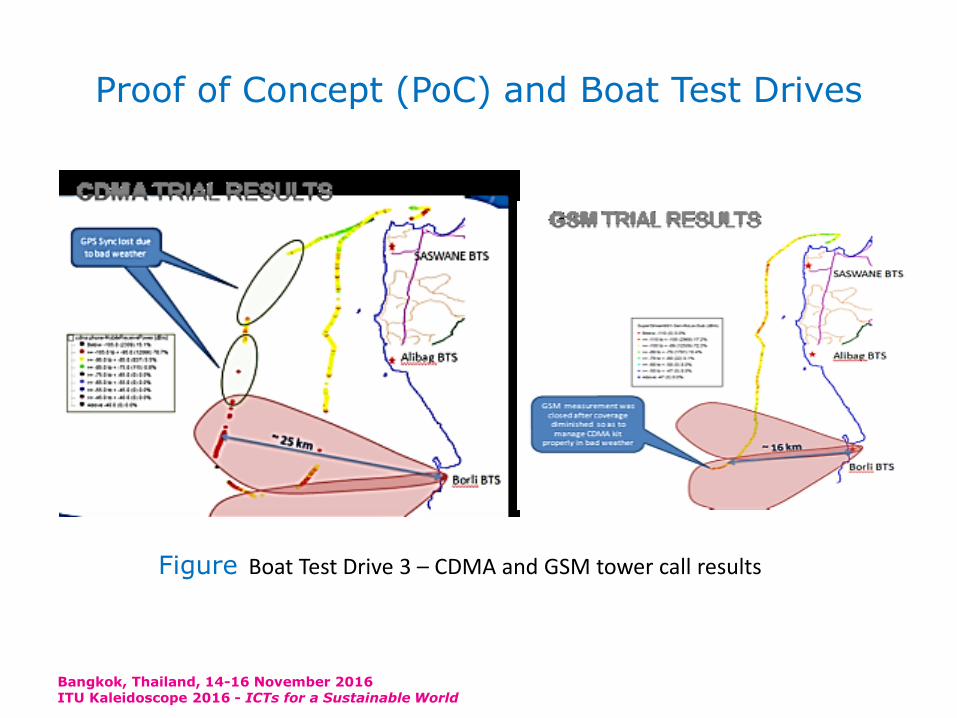
• Boat Test Drive 3 – BTS configuration:– installed CDMA Base Station Transceiver System (BTS) at
two sites in Raigad district i.e. at Sasawane and Varsoli and a CDMA + GSM BTS at Borli-Mandla sites.
– the cellular technology and type of the BTS to be used to achieve the maximum distance in the sea.
•
Bangkok, Thailand, 14-16 November 2016ITU Kaleidoscope 2016 - ICTs for a Sustainable World
Proof of Concept (PoC) and Boat Test Drives
Bangkok, Thailand, 14-16 November 2016ITU Kaleidoscope 2016 - ICTs for a Sustainable World
CDMA TRIAL SETUP GSM TRIAL SETUP
CDMA 850 MHz
Coverage reach for CDMA
(Voice + Data) – approx
25 km
This is with conventional
solution –
Standard BTS – No Tower
Top solution
Normal Gain antenna used
No special feature used
Incidental coverage beyond
25km may be possible
The coverage reach can be
further enhanced, with
Tower Top BTS, High gain
antennae (20.5 dB gain), to
30+ km
GSM 1800 MHz
Coverage reach for GSM
(Voice + Data) – approx
16 km
This is with un-
conventional solution –
Tower Top BTS.
.
Normal Gain antenna used
Special feature PBT
deployed
Incidental coverage
beyond 16km may be
possible
The coverage reach can be
further enhanced, with
High gain antenna (20.5
dB gain), to 20+ km
Table 1 Boat Test Drive 3 - Test Results
Figure Boat Test Drive 2 for GSM vs. CDMA test
Proof of Concept (PoC) and Boat Test Drives
Bangkok, Thailand, 14-16 November 2016ITU Kaleidoscope 2016 - ICTs for a Sustainable World
Figure Boat Test Drive 3 – CDMA and GSM tower call results
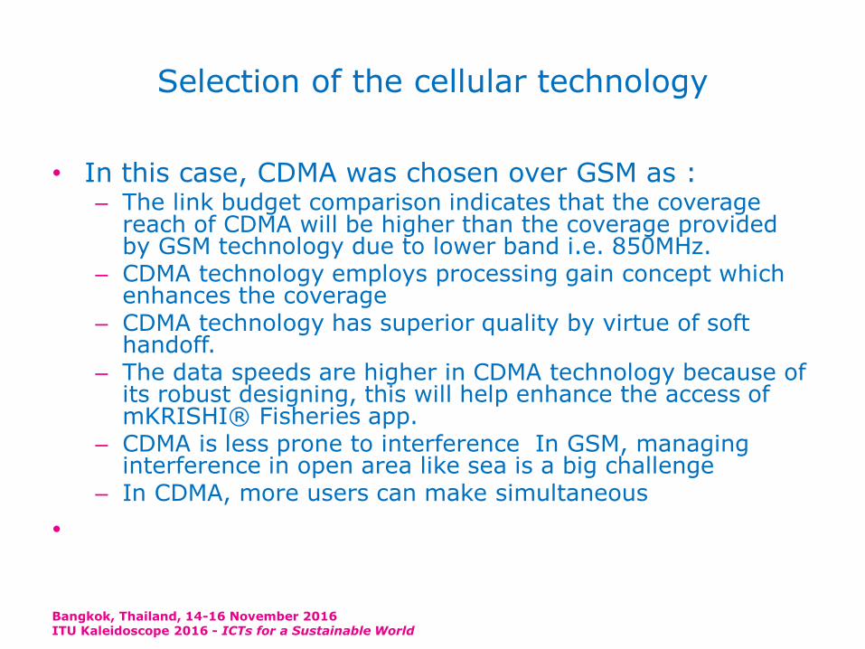
Selection of the cellular technology
• In this case, CDMA was chosen over GSM as :– The link budget comparison indicates that the coverage
reach of CDMA will be higher than the coverage provided by GSM technology due to lower band i.e. 850MHz.
– CDMA technology employs processing gain concept which enhances the coverage
– CDMA technology has superior quality by virtue of soft handoff.
– The data speeds are higher in CDMA technology because of its robust designing, this will help enhance the access of mKRISHI® Fisheries app.
– CDMA is less prone to interference In GSM, managing interference in open area like sea is a big challenge
– In CDMA, more users can make simultaneous
•
Bangkok, Thailand, 14-16 November 2016ITU Kaleidoscope 2016 - ICTs for a Sustainable World
Selection of the cellular technology
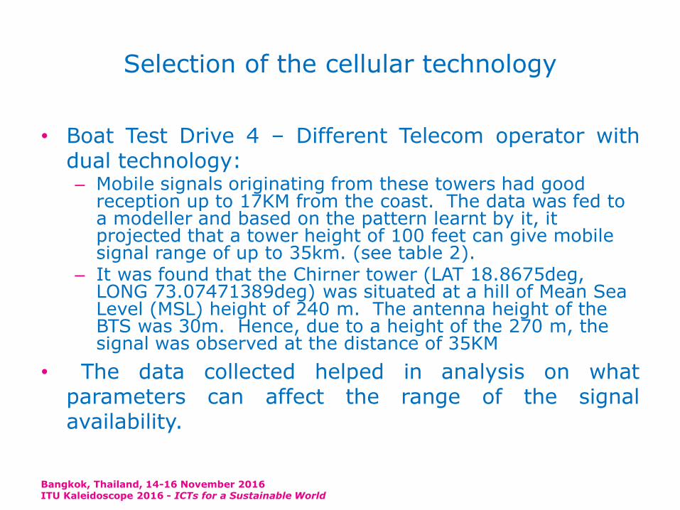
• Boat Test Drive 4 – Different Telecom operator withdual technology:– Mobile signals originating from these towers had good
reception up to 17KM from the coast. The data was fed to a modeller and based on the pattern learnt by it, it projected that a tower height of 100 feet can give mobile signal range of up to 35km. (see table 2).
– It was found that the Chirner tower (LAT 18.8675deg, LONG 73.07471389deg) was situated at a hill of Mean Sea Level (MSL) height of 240 m. The antenna height of the BTS was 30m. Hence, due to a height of the 270 m, the signal was observed at the distance of 35KM
• The data collected helped in analysis on whatparameters can affect the range of the signalavailability.
Bangkok, Thailand, 14-16 November 2016ITU Kaleidoscope 2016 - ICTs for a Sustainable World
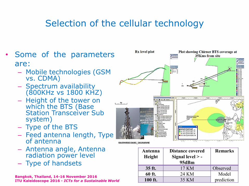
Selection of the cellular technology
• Some of the parametersare:– Mobile technologies (GSM
vs. CDMA)– Spectrum availability
(800KHz vs 1800 KHZ) – Height of the tower on
which the BTS (Base Station Transceiver Sub system)
– Type of the BTS– Feed antenna length, Type
of antenna– Antenna angle, Antenna
radiation power level– Type of handsets
Bangkok, Thailand, 14-16 November 2016ITU Kaleidoscope 2016 - ICTs for a Sustainable World
Antenna
Height
Distance covered
Signal level > -
95dBm
Remarks
35 ft. 17 KM Observed
60 ft. 24 KM Model
prediction100 ft. 35 KM

Tower installation and commissioning
• TTL surveyed the Raigad districts mobile towers andpicked up 7-8 sites where work needs to be carriedout to expand the signal up to 30+ KM in the sea .
• On six existing towers, following configurations weredone to increase coverage.– Tower Top BTS (Feeder less)– Std 33deg antenna – High Gain ~20.5 dBi
• One new tower erected and equipped with below :– Tower erection, Installation of the tower top BTS Or Remote
Radio unit (RRU)s and Feeder cables– Antennas – MRFU V2 900MHZ CDMA (SUPPORT 4 TRX, 20W
TOC,25MHZ IBW)– Power, Diesel Generator, Microwave Link– Installation and commissioning– IP Clearance, Site RFI, WPC certification
Bangkok, Thailand, 14-16 November 2016ITU Kaleidoscope 2016 - ICTs for a Sustainable World
Mobile Signal Extension in Deep Sea – Pilot
• Initially no telecom operatorshowed interest. Eventually TataTeleservices agreed to do a pilotgiven the societal nature of theinterventions.
• The entire mobile signal extensiontesting approach was divided intofour phases:– Proof of Concept (PoC) and Boat Test
Drive– Selection of cellular technology– Tower installation and commissioning– Parametric test based detailed study
of major operator’s signal
•
Bangkok, Thailand, 14-16 November 2016ITU Kaleidoscope 2016 - ICTs for a Sustainable World
Site Name
BTS
ID
Se
cto
r #
Latitu
de
Longi
-tude
Ht.
(ft)
Sasavane 380 3
18.787
4
72.865
4 45
Varsoli_Ali
baug 381 3
18.666
78
72.868
75 35
Borli-
Mandla 382 3
18.510
5
72.913
2 50
Murud_Rai
gad 387 2
18.337
3
72.959
160
Borli
Panchtan 384 3
18.162
7
73.001
955
Shreevardha
n 385 2
18.051
7
73.026
350
Aravi386 2
18.084
8
73.006
250
Installed tower locations and details
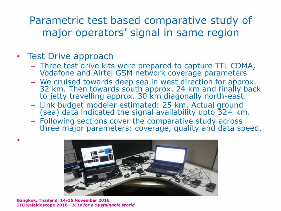
Parametric test based comparative study of major operators’ signal in same region
• Test Drive approach– Three test drive kits were prepared to capture TTL CDMA,
Vodafone and Airtel GSM network coverage parameters– We cruised towards deep sea in west direction for approx.
32 km. Then towards south approx. 24 km and finally back to jetty travelling approx. 30 km diagonally north-east.
– Link budget modeler estimated: 25 km. Actual ground (sea) data indicated the signal availability upto 32+ km.
– Following sections cover the comparative study across three major parameters: coverage, quality and data speed.
•
Bangkok, Thailand, 14-16 November 2016ITU Kaleidoscope 2016 - ICTs for a Sustainable World
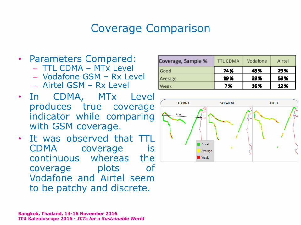
Coverage Comparison
• Parameters Compared:– TTL CDMA – MTx Level– Vodafone GSM – Rx Level– Airtel GSM – Rx Level
• In CDMA, MTx Levelproduces true coverageindicator while comparingwith GSM coverage.
• It was observed that TTLCDMA coverage iscontinuous whereas thecoverage plots ofVodafone and Airtel seemto be patchy and discrete.
Bangkok, Thailand, 14-16 November 2016ITU Kaleidoscope 2016 - ICTs for a Sustainable World
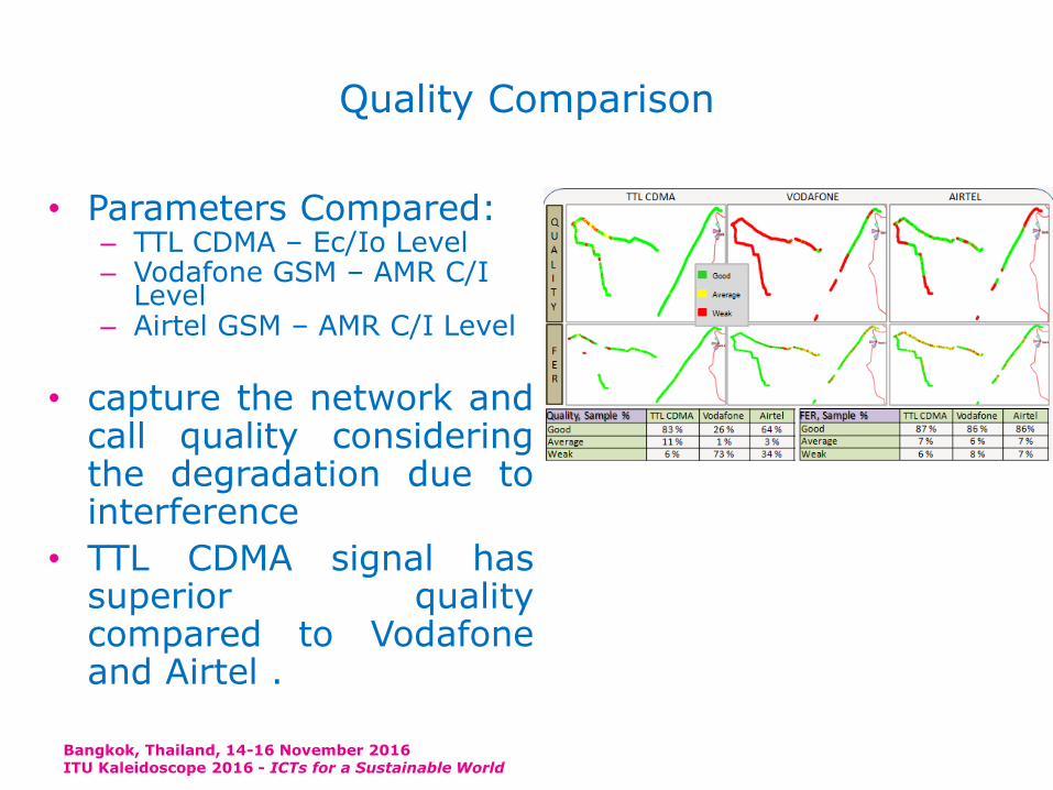
Quality Comparison
• Parameters Compared:– TTL CDMA – Ec/Io Level– Vodafone GSM – AMR C/I
Level– Airtel GSM – AMR C/I Level
• capture the network andcall quality consideringthe degradation due tointerference
• TTL CDMA signal hassuperior qualitycompared to Vodafoneand Airtel .
Bangkok, Thailand, 14-16 November 2016ITU Kaleidoscope 2016 - ICTs for a Sustainable World
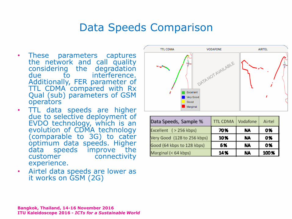
Data Speeds Comparison
• These parameters capturesthe network and call qualityconsidering the degradationdue to interference.Additionally, FER parameter ofTTL CDMA compared with RxQual (sub) parameters of GSMoperators
• TTL data speeds are higherdue to selective deployment ofEVDO technology, which is anevolution of CDMA technology(comparable to 3G) to cateroptimum data speeds. Higherdata speeds improve thecustomer connectivityexperience.
• Airtel data speeds are lower asit works on GSM (2G)
Bangkok, Thailand, 14-16 November 2016ITU Kaleidoscope 2016 - ICTs for a Sustainable World
Conclusion
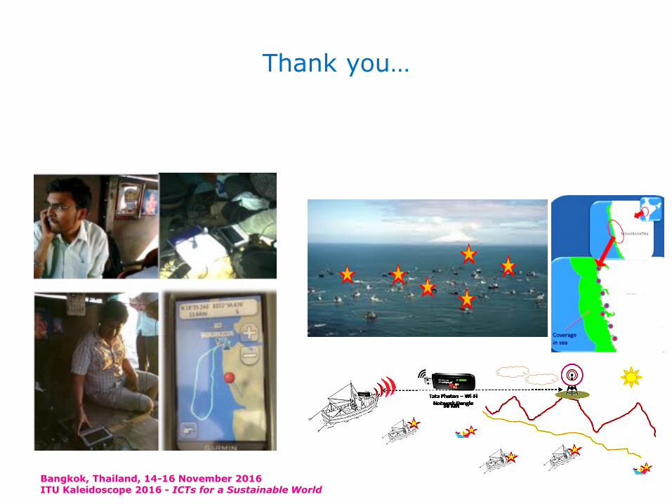
• Good quality mobile signal coverage upto 30-35km in deep sea.• This provided an extended accessibility to the ICT network
which helped enable a better use of the technology for a betterlivelihood and safety management.
• Fishermen used the extended signal to call for help when a boatwas overloaded with the catch and could have toppled in thesea. This helped in transferring the excess load.
• fisher with the large catch quantity, could connect with the localtraders at the landing center and negotiate the price. Thishelped to preserve the quality of the fish and adequate ice,labor and truck could be arranged, even before the catch landedat the sea.
• A combination of the wireless VHF sets and mobile phonesprovided a further extended in deep sea upto 60-70 km.
• This pilot experience presents a model for extending the earlywarning system using ICT in deep sea
Bangkok, Thailand, 14-16 November 2016ITU Kaleidoscope 2016 - ICTs for a Sustainable World
Thank you…
Bangkok, Thailand, 14-16 November 2016ITU Kaleidoscope 2016 - ICTs for a Sustainable World

![Deep Learning for Electromyographic Hand Gesture Signal ... · techniques applied to EMG classification is given in [26]. To the best of our knowledge, this paper, which is an extension](https://img.pdfslide.net/doc/110x75/5ed9dab67e70d7589f0b6224/deep-learning-for-electromyographic-hand-gesture-signal-techniques-applied-to.jpg)