Embed Size (px)
Citation preview

DONCASTER
HILLMODES H I F TPLAN2 0 1 4
“A travel plan for moving people within
and beyond Doncaster Hill, safely, efficiently
and sustainably”
Table of Contents
1.0 Introduction ...................................... .................................................................. 3
2.0 Why develop a Mode Shift Plan? .................... .................................................. 4
3.0 Background ........................................ ................................................................ 6 Doncaster Hill Traffic and Parking Study 2011 .............................................................. 6 Bus Service Improvements ............................................................................................ 7 Walking and Cycling In Doncaster Hill ........................................................................... 8
3.1 Case Study Review .................................................................................... 9
4.0 Data and Site Observations ........................ .................................................... 12 4.1 Doncaster Hill Site Constraints ................................................................. 18
5.0 Mode Shift Plan Themes and Goals .................. ............................................. 21 Theme 1 Infrastructure .................................................................................. 21 Theme 2 Advocacy ........................................................................................ 22 Theme 3 Behaviour Change .......................................................................... 22 Theme 4 Planning ......................................................................................... 23 5.1 Goals ........................................................................................................ 24
Goal 1: Walking / Cycling ............................................................................................. 24 Goal 2: Public Transport .............................................................................................. 27 Goal 3: Roads and Parking .......................................................................................... 29 Goal 4: Behaviour Change / Cultural Change ............................................................. 32
6.0 Consultation ...................................... ............................................................... 34
7.0 State Government Context .......................... .................................................... 35
8.0 Local Government Context .......................... ................................................... 38
9.0 Achievement of Mode Shift / Monitoring and Review . .................................. 42
10.0 Action Plan ....................................... ................................................................ 43 10.1 Action Plan ............................................................................................... 44
Appendix A......................................... ..........................................................................51

Page | 3
1.0 Introduction
Doncaster Hill is a 58-hectare area located in Doncaster stretching along the major corridors of Doncaster Road, Williamsons Road, Elgar Road and Tram Road. It is located approximately 14 kilometres from the Melbourne Central Business District and is one of the highest points in Melbourne (highest natural elevation of 127 metres) showcasing views of the Dandenongs, Kinglake Ranges and the panoramic Melbourne City skyline. The Doncaster Hill Activity Centre area is regarded as a prime location for redevelopment based on topographic features and physical and community infrastructure assets. The Doncaster Hill Strategy 2002 (revised 2004) vision is for a state-of-the-art, contemporary, sustainable, high-density, mixed-use village that enhances the social, environmental, economic and cultural elements of the City of Manningham.
Central to this vision is the achievement of a sustainable transport future for people of all abilities, through changing travel behaviours by encouraging increased public transport use and reduced levels of car dependency. Doncaster Hill aims to be pedestrian friendly with tree-lined streets alive with restaurants, cafes, shops, public art and open spaces. It is expected that a mix of new residents will move into Doncaster Hill, including, students, young professionals, residents downsizing from larger residential properties, and residents requiring more affordable housing options.
The intersection of Doncaster, Williamsons and Tram roads is perfectly situated to link neighbouring residential areas, through improved pedestrian/bicycle/public transport and improved safety and amenity.
Doncaster Hill comprises seven distinct precincts and is bordered to the west by the Eastern Golf Club, to the north by Westfield Drive, to the east by the Manningham Civic Centre and to the south by Merlin Street.
Figure 1
Doncaster Hill Precincts Image Source: www.doncasterhill.com

Page | 4
2.0 Why develop a Mode Shift Plan? Micro simulation modelling undertaken in support of the Doncaster Hill Traffic and Parking Study found that congested traffic conditions similar to an inner city activity centre are projected unless mode shift to sustainable transport modes in the order of 30% can be achieved at full build out of the Hill in the weekday PM peak period. The modelling also found that through traffic is projected to decrease slightly and the increase in projected traffic flows is due to locally generated traffic.
Taking into account the recommendations of the 2011 Parking and Traffic Management Review, Council resolved at its meeting in May 2013 to ‘investigate and develop a Doncaster Hill Mode Shift Plan, to assist the Doncaster Hill community, to maximise the achievement of transport mode shift’.
Council Plan (2013-2017), Goal No. 4.3.2 requires Council to "Continue to implement the Doncaster Hill Strategy, including actions to direct greater use of public transport and local pedestrian and cycle trips".
The purpose of the Doncaster Hill Mode Shift Plan is to identify actions to encourage a mode shift of 30% to sustainable transport modes, prior to full development of the Hill, which is anticipated to occur in the next 20 to 30 years.
The achievement of mode shift is a complex issue, requiring a coordinated, long term approach across State and Local Government, developers and the community. The attractiveness, accessibility, reliability, efficiency and integration of sustainable transport modes such as public transport, cycling and walking are all considered key factors if mode shift is to be achieved. Actions to encourage mass behaviour change also need to be identified and implemented. In addition, the management and supply of parking facilities requires careful control.
A study commissioned by the Federal Government’s Bureau of Transport and Regional Economics (BTRE) on the cost of congestion indicates that total travel in Australian urban areas has grown significantly over the last 60 years with the projected kilometres travelled between 2005 and 2020 increasing by 37 percent. The social cost of this congestion for Melbourne is projected to rise from $3 billion to $6.1 billion dollars by the year 2020. (Source: Bureau of Transport and Regional Economics, Estimating urban traffic and congestion cost trends for Australian Cities, Working
paper No 71).
Given these significant increases, it is imperative that there is a shift towards more sustainable forms of transport, in particular in areas where high density living is proposed such as Doncaster Hill.
The current mode share for walking, cycling and public transport use, as the main method of travel for Doncaster Hill is 19.6% with the current mode split being as follows: (source: ABS Census Data 2011)
• Bus – 14.7%
• Walk Only – 4.9%
• Bicycle only – 0%

Page | 5
Australian Bureau of Statistics data indicates that Manningham has one of the highest car ownership rates in metropolitan Melbourne (two vehicles per household compared to the metropolitan average of 1.7 vehicles per household), which is a reflection of the limited of public transport options to and within the municipality. However, since the introduction of the DART bus services in 2010, public transport use has increased.
It is also noted that in Melbourne 47% of all trips less than 2.5km are taken by private vehicle with over 50% of all trips (whether by walking, cycling, public transport or private car) taking less than 12 minutes each. (Source: Moving to Healthier People, Healthier Places, VicHealth 1999)
Given that a large proportion of all trips are less than 2.5km there is significant scope to encourage a change of travel choices to more sustainable forms of transport. This Plan therefore aims to encourage a further 10.4% mode shift to walking, cycling and public transport to move toward an overall sustainable mode share of 30% for Doncaster Hill.
It is noted that the State Government has undertaken a feasibility study on the provision of rail to Doncaster and that the State Governments’ Plan Melbourne Strategy has proposed the rail to Doncaster be delivered within the 2025 to 2050 year timeframe. Given the long term nature of the provision of Doncster Rail, significant bus and public transport improvements are required in the interim to achieve a 30% mode share by 2030. As a result, the actions identified in this plan do not rely on the implementation of Doncaster Rail

Page | 6
3.0 Background The Doncaster Hill Strategy is a long term strategy that was initially adopted by Council in 2002 and later revised in 2004. The vision of the Doncaster Hill Strategy is to facilitate the development of more than 4,000 new residential apartments, 10,000m2 retail and 20,000m2 commercial / office space. The population of Doncaster Hill is set to increase by 7,000 residents by full build out. It is Council’s response to increased demand for more appropriate, sustainable and diverse housing options that can accommodate the municipality’s changing demographic and social needs.
Transport mode choice is a complex issue and is influenced by a wide variety of factors which including the following.
• Higher density neighbourhoods with easy access to shopping and work.
• The degree of integration of land uses with transportation systems.
• The relative efficiency, reliability, quality and frequency of transport services.
• Comfort, safety and convenience of transport services and transport options.
• The availability of appropriate infrastructure to facilitate sustainable transport modes.
• Age and sex of commuters.
• The number of cars available to a household.
• Sustained behaviour change programs including community engagement, marketing, promotion and communication of sustainable transport options.
Doncaster Hill Traffic and Parking Study 2011
In 2011, Council commissioned a review of parking and traffic management in Doncaster Hill. Traffic modelling conducted as part of this review, indicated that at 100% build-out of Doncaster Hill, assuming that the current transport mode share continues, there would be capacity constraints along the road network with limited opportunities to accommodate the projected growth in traffic volumes in the next 20-30 years. Congested traffic conditions similar to an inner city activity centre are expected. Increased traffic volumes will result in the following impacts.
• Increased travel times and slower vehicle speeds in and around Doncaster Hill.
• Reduced performance of the road based public transport system within the local area.
• Increased queuing and delays at key intersections with limited gap opportunities for vehicles entering the arterial road network from the local road network.

Page | 7
As a result, the key recommendations of the parking and traffic management review were as follows.
• Facilitate a 30% mode shift to more sustainable modes of transport.
• Advocate for improvements to public transport services, including dedicated bus lanes to improve public transport efficiency.
• Encourage walking and cycling, in particular for short trips.
• Discourage car ownership within new developments.
• Discourage through traffic.
• Integrate transport and land uses.
Through developing this Plan, Council undertook various studies and research to inform the preparation of the action plan.
Bus Service Improvements
In 2009 the State Government through the then bus operator National / Ventura, conducted a bus services review of all bus services within metropolitan Melbourne. The bus services review included consultation with the local community and Local Government and resulted in a recommendation to substantially increase the level and frequency of bus services in Manningham.
In October 2010, four existing local bus routes were upgraded to provide regular and frequent services between Manningham and the Melbourne Central Business District (CBD). These services now form part of the Doncaster Area Rapid Transit (DART) network. These DART services now provide an additional 107,000 trips per year to the Manningham area.
Of the four DART services operating in Manningham, Route 907, services Doncaster Hill. Route 907 operates between the Melbourne CBD (Lonsdale Street) and Mitcham Railway Station. This service travels along Doncaster Road, however does not service the Doncaster bus interchange located within Westfield Doncaster.
The frequency of the 907 Route ranges between 7-10 minutes during peak periods, 15 minutes during the remainder of the weekday until 9:00pm, then at 30 minute intervals until midnight. During the weekend, the DART service operates every 30 minutes to midnight on Saturday and every 30 minutes until 9:30pm on Sundays.
On an average weekday, the 907 bus service carries over 4,000 passengers. Between 2010/11 and 2011/12, Route 907 experienced a 57% increase in patronage to more than 1.1 million patrons annually. In an average week, the 907 service carries 23,136 passengers and is the busiest of the four DART services between Manningham and the Melbourne CBD.
Current travel times between the CBD and the Eastern Freeway during the peak periods can take anywhere between 5-25 minutes.
In the evening peak, the journey between the CBD and Eastern Freeway outbound (according to the current PTV timetable) takes 17 minutes off-peak and 27 minutes during peak, an increase of 10 minutes, possibly reflecting the lack of bus priority for the outbound lanes on the freeway.

Page | 8
It is worth noting that in the context of a full journey from the CBD to Doncaster Park and Ride, the normal journey time (say at 11pm at night) takes 28 minutes, whereas during the peak (at 6pm) it takes 43 minutes, a 54% increase in travel time (however, delays occurred by more passengers boarding/alighting need to be taken into consideration). In contrast, the reverse journey between Doncaster Park and Ride and the CBD in the morning peak (8am) takes 35 minutes (as there are inbound bus lanes).
Information provided by PTV indicates that the above bus network improvements will result in an 8 to 10 minute time saving when the bus lanes come into operation.
Furthermore, in April 2014, the Victorian Coalition Government announced improvements to the DART bus network by allocating funding to the Victoria Parade and Hoddle Street Bus Upgrade Project. This project includes the following items.
• Provision for new full time bus lanes along Victoria Parade and Hoddle Street.
• Upgraded bus stops along these roads.
• Signaling improvements to give greater priority to public transport.
• Improved bicycle and pedestrian connections.
• Lane management technology (dynamic lane management).
In late 2013, a new bus operator was appointed by the State Government to operate the majority of bus services within Manningham and wider metropolitan Melbourne. At the time of preparing this plan, the new operator, Transdev, was preparing to implement the results of a review of the existing bus services within Manningham, with the intention of minimising duplication of bus routes to improve other key services and introducing a new timetable.
It is however noted that the new timetable within Manningham will require patrons to transfer more often between bus services, in particular at the Westfield Doncaster bus interchange. Given this, it is essential the Doncaster Westfield Bus Interchange is easily accessible via walking and cycling and that the bus interchange is located in a prominent, central and pedestrian friendly location.
It has been advised that in early 2015, Transdev proposes to undertake a greenfield review of all bus services within Manningham and metropolitan Melbourne with the view of improving bus services and further increasing patronage.
Notwithstanding the significant increase in bus patronage through Doncaster Hill and the proposed upgrades to bus facilities in inner Melbourne, it is crucial that bus service frequency and span of hours is significantly improved to provide a service equivalent to a rail service, and to cater for the projected increase in population of Doncaster Hill.
Walking and Cycling In Doncaster Hill
The Doncaster Hill Pedestrian and Cycling Plan (February 2010) identifies future works to be undertaken, to ensure stronger links to public transport and key attractors. It also responds to health and social issues and identifies opportunities, to facilitate delivery of these works and initiatives through the action plan.
Council has commenced work on creating a network of improved pedestrian and cycling links around Doncaster Hill. The first stage of this was completed in mid-2008 with a shared path constructed between Precinct 1 and Westfield Doncaster. Widened walking and cycling
Page | 9
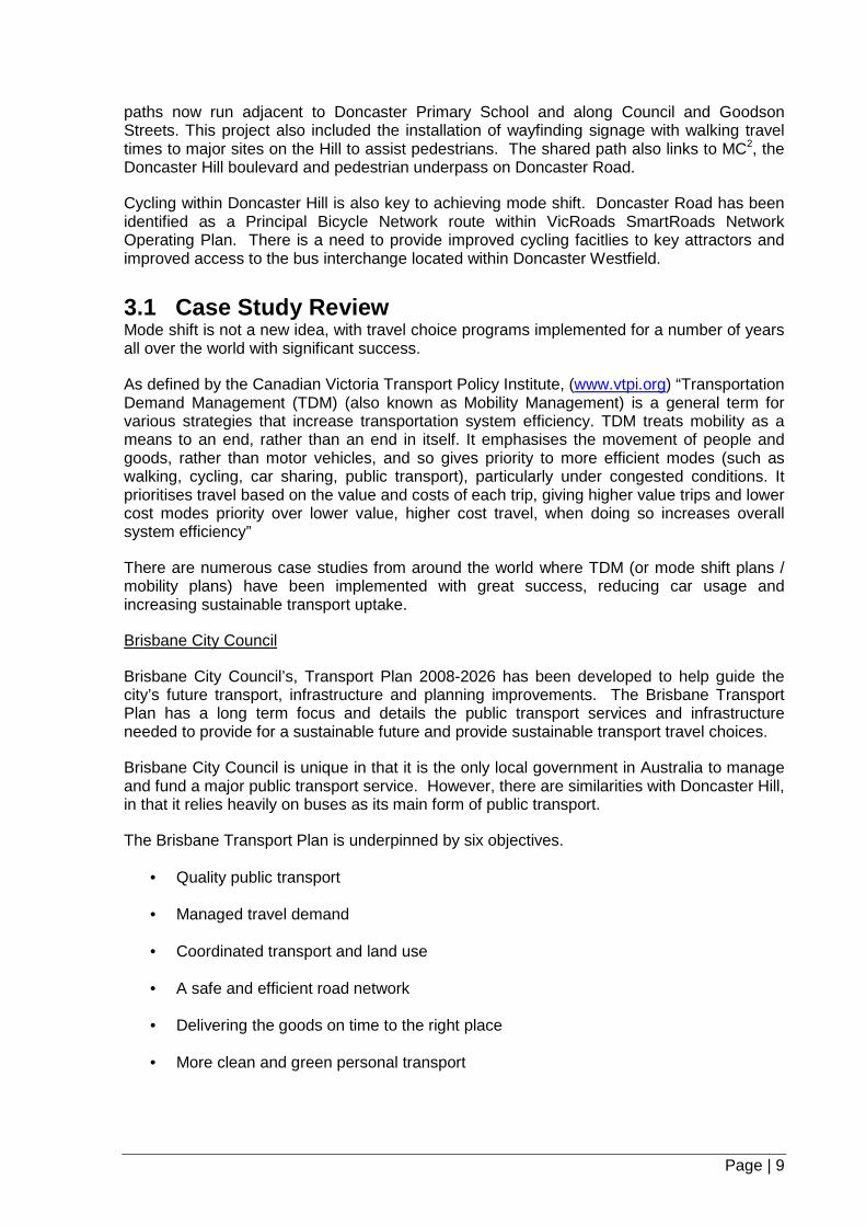
paths now run adjacent to Doncaster Primary School and along Council and Goodson Streets. This project also included the installation of wayfinding signage with walking travel times to major sites on the Hill to assist pedestrians. The shared path also links to MC2, the Doncaster Hill boulevard and pedestrian underpass on Doncaster Road.
Cycling within Doncaster Hill is also key to achieving mode shift. Doncaster Road has been identified as a Principal Bicycle Network route within VicRoads SmartRoads Network Operating Plan. There is a need to provide improved cycling facitlies to key attractors and improved access to the bus interchange located within Doncaster Westfield.
3.1 Case Study Review Mode shift is not a new idea, with travel choice programs implemented for a number of years all over the world with significant success.
As defined by the Canadian Victoria Transport Policy Institute, (www.vtpi.org) “Transportation Demand Management (TDM) (also known as Mobility Management) is a general term for various strategies that increase transportation system efficiency. TDM treats mobility as a means to an end, rather than an end in itself. It emphasises the movement of people and goods, rather than motor vehicles, and so gives priority to more efficient modes (such as walking, cycling, car sharing, public transport), particularly under congested conditions. It prioritises travel based on the value and costs of each trip, giving higher value trips and lower cost modes priority over lower value, higher cost travel, when doing so increases overall system efficiency”
There are numerous case studies from around the world where TDM (or mode shift plans / mobility plans) have been implemented with great success, reducing car usage and increasing sustainable transport uptake.
Brisbane City Council
Brisbane City Council’s, Transport Plan 2008-2026 has been developed to help guide the city’s future transport, infrastructure and planning improvements. The Brisbane Transport Plan has a long term focus and details the public transport services and infrastructure needed to provide for a sustainable future and provide sustainable transport travel choices.
Brisbane City Council is unique in that it is the only local government in Australia to manage and fund a major public transport service. However, there are similarities with Doncaster Hill, in that it relies heavily on buses as its main form of public transport.
The Brisbane Transport Plan is underpinned by six objectives.
• Quality public transport
• Managed travel demand
• Coordinated transport and land use
• A safe and efficient road network
• Delivering the goods on time to the right place
• More clean and green personal transport

Page | 10
A key focus of the managed travel demand objective listed above is reducing congestion and improving person throughput, by encouraging travel behaviour changes through various programs to increase sustainable transport mode share.
As a result Brisbane Council has initiated implementation of its Active Communities program, which is an initiative to encourage cycling and walking in ten Brisbane suburbs. Promoting cycling and walking around Brisbane is part of the Council’s plan to reduce congestion, encourage green, healthy and active travel and keep the city moving.
The Active Communities program will roll out over four years in suburbs which were selected using a range of criteria including existing infrastructure, cycling suitability, local shops, number of schools and number of trips within a five kilometre radius.
Consultation with Brisbane Council officers indicates that the implementation of their Active Communities program is generally low cost yet resource and time intensive. Their experience to date has been that the messages promoted to the community via their behaviour change programs must be consistent and delivered on a regular long term basis to ensure that the community continues to be engaged in the process, until such time that the travel choices occur as “an everyday habit” e.g. walk to the shop as a part of your daily routine as opposed to driving the short distance.
Seattle, Washington (USA)
In 2008, Seattle in the United States of America developed its Seattle Urban Mobility Plan, which is its transport plan that focuses on improving mobility and access to and through Seattle’s City Centre. As stated in Part 7 of the Seattle Plan, Transportation Demand Management (TDM) seeks to reduce the number of vehicle trips, by increasing travel options, by providing incentives and information to encourage and help individuals to modify their travel behaviour, and / or by reducing the physical need to travel through the provision of transportation efficient land uses”
Seattle has in part achieved mode shift by not requiring a minimum number of parking spaces for residential uses over the last 20 years. In addition, Seattle has introduced a maximum number of parking spaces for commercial and office developments and is looking to further expand the capping of the number of parking spaces to residential developments.
As indicated in the Seattle plan, mode shift is achieved when a number of land use and community strategies are packaged together, including parking management, compact mixed use development, high capacity efficient transit services, and social marketing and incentive programs.
Currently Manningham Council is in a unique position in that the Doncaster Hill Strategy provides a guide as to the number of apartments to be constructed over the next 20 years. As such Council may have the ability to influence the design and management of these developments through possible changes to the Manningham Planning Scheme to facilitate and encourage mode shift within Doncaster Hill. In addition, the vision for Doncaster Hill is the development of a high density mixed use village which is consistent with transport efficient land use planning.

Page | 11
Portland, Oregon (USA)
In 2003, the City of Portland conducted an individualised marketing program based on Australia’s TravelSmart program, to reduce single occupant vehicle trips and increase the mode share of walking, cycling, and public transport. The “SmartTrips” pilot programs were conducted in 2003 and 2004. The SmartTrips programs had five main goals:
• Reducing drive alone trips;
• Reducing vehicle miles driven by area residents and employees;
• Increasing awareness and raising acceptability of all travel modes;
• Increase uptake of walking, cycling, public transport, car pooling and car sharing trips; and
• Increasing neighbourhood mobility and liveability.
SmartTrips is a comprehensive behaviour change program, which relies heavily on individualised marketing to encourage sustainable travel choices. The program operated on the assumption that many people will shift to less expensive and healthier, sustainable transport modes if they were aware of all of their travel options.
The marketing approach taken included hand delivered packets of information to residents who sought to learn more about their travel options. The main components of the program featured cycling and walking maps, organised activities to encourage residents to discover how many trips they can easily, conveniently and safely make without using their private vehicles.
The key to the program’s success was the speed and efficiency at which information was delivered to residents. The program initially began with a newsletter to residents, advising them of the SmartTrips program with a form for them to complete if they wished to seek further information such as maps, brochures, tips or event schedules for every mode of transport available. This requested information was generally sent within one week of receiving the order, but no longer than three (3) weeks. The majority of the material sent to residents was hand delivered to ensure efficiency of the service. A couple of months later residents were then sent a letter reminding them that they could order materials, information, maps etc.
This consistent messaging from the City of Portland and hands on approach has resulted in a significant reduction of drive alone trips of between 9 and 13 percent, with a corresponding increase in walking, cycling, public transport use and car pooling in SmartTrips areas.
In total, residents receive correspondence from SmartTrips at least seven times during the course of the program over one year. Information provided indicates that the program costs in the order of US$10 per person in a SmartTrips area, with a typical 20,000 household program costing approximately US$570,000. This cost also includes 4.35 full time staff and most materials and services. (Source www.walkinginfo.org )
It is evident from the Portland SmartTrips program that staff resourcing and consistent marketing can result in a significant increase in sustainable transport mode uptake.
From 2006 to 2009, the City of Portland, built on the success of the suburban SmartTrips program and conducted a behaviour change program called “SmartTrips Downtown”. This program was an individualised marketing program designed to reduce traffic congestion by helping downtown CBD employees utilise more efficient and sustainable modes of transport.

Page | 12
4.0 Data and Site Observations
The Doncaster Hill Strategy aims to facilitate development of more than 4,000 new residential apartments, retail and office space and attract an extra 7 million visitors per year.
Data sourced from the 2011 census indicate that there were 1,194 residents living within Doncaster Hill. However, this figure does not include the 450 new apartments that were completed after the census data was collected.
Figure 2 Population in Doncaster Hill – 2011 (Census source: profile.id.)

Page | 13
By the year 2036, at full build out, it is projected that the population of Doncaster Hill will increase by more than 6,000 people to approximately 7,553 residents. An increase in the number of employees working within the Hill in proposed commercial premises, including any future expansion of Westfield Doncaster is also expected.
Figure 3 Future Population in Doncaster Hill (Census source: profile.id)
Travel to Work 2011 census data indicates that in comparison to the wider Manningham area, uptake of sustainable transport modes within Doncaster Hill is proportionally greater. Bus and walking only for travel to work journeys represents a mode share of 19.6% in Doncaster Hill as compared to 8.6% for the City of Manningham as a whole.
It is noted that between 2006 and 2011, there has been an increase of 3.6% in bus travel in Doncaster Hill based on place of residence data and shown in Figure 4 below.
Given that the 2011 census was undertaken prior to the completion of a number of residential and mixed use developments within the Hill, it is reasonable to assume that these figures will continue to grow as new developments are constructed and occupied. This also suggests that the demographic of the Doncaster Hill community is willing to consider alternative modes of transport rather than relying solely on private vehicle use as the main mode of transport.

Page | 14
Figure 4 Method of Travel to Work
Doncaster Hill Compared with the City of Manningham

Page | 15
Community Online Survey
In early 2014, an online community survey was carried out inviting all residents, employees and employers of businesses within Doncaster Hill (excluding Council employees**) to participate in a travel choice survey. The aim of the survey was to determine what influences people to travel via a particular mode and what may influence them in the future to amend their behaviour and choose sustainable modes of transport. (** - a separate program is proposed for Council employees to encourage sustainable travel to and from the Municipal Offices in Doncaster Hill)
A total of 1478 surveys were distributed to residents and businesses located within Doncaster Hill. Of the eighty five responses to the online survey, 48.2% of respondents live in Doncaster Hill, 49.4% work in Doncaster Hill and 2.4% both work and live in Doncaster Hill. The vast majority (74.4%) travel by private vehicle during the weekday PM peak period (4:00pm to 7:00pm).
Figure 5
Resident vs. Employee in Doncaster Hill
Figure 6 How do you usually travel during the weekday PM peak period (4:00pm to 7:00pm)
Page | 16
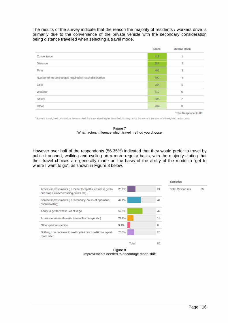
The results of the survey indicate that the reason the majority of residents / workers drive is primarily due to the convenience of the private vehicle with the secondary consideration being distance travelled when selecting a travel mode.
Figure 7 What factors influence which travel method you choose
However over half of the respondents (56.35%) indicated that they would prefer to travel by public transport, walking and cycling on a more regular basis, with the majority stating that their travel choices are generally made on the basis of the ability of the mode to “get to where I want to go”, as shown in Figure 8 below.
Figure 8 Improvements needed to encourage mode shift

Page | 17
As illustrated by the results of the community survey, a large number of respondents are willing to consider other modes of transport in place of the private vehicle travel. However it appears there is a perceived lack of information on how to travel from place to place, or infrastructure constraints limit ability to view other modes of transport as a viable option.
Off Street Car Parking Study (2014)
The Doncster Hill Traffic and Parking Study 2011 found that in the weekday PM peak period, traffic congestion similar to an inner city activity centre would be expected at full build out of Doncaster Hill, unless mode shift of 30% could be achieved. The study at the time assumed 100% projected car park occupancy.
The 2011 Study also found that increases in traffic within Doncaster Hill will primarily emanate from locally generated traffic.
As a result it was determined that a study was required of existing residential developments within Doncaster Hill to determine the current parking demand in those developments. Residential parking surveys were conducted at six residential developments in March 2014.
The results of the parking survey indicate that the peak parking demand occurred at 6:00am, with an overall average parking demand of 0.76 spaces per apartment
632 Doncaster Rd
91 Tram Rd 95 Tram Rd (affordable housing)
14-16 Berkeley St & 16 Tower St
6-12 Berkeley St
7 Berkeley St
NUMBER OF APARTMENTS
158 83 98 49 69 69
BREAKDOWN OF APARTMENTS
1 bed – 71 2 bed – 85 3+ bed – 2
1 bed – 34 2 bed – 44 3+ bed – 5
1 bed – 20 2 bed – 58 3+ bed – 20
1 bed – 8 2 bed – 29 3+ bed – 12
1 bed – 10 2 bed – 31 3+ bed – 28
1 bed – 34 2 bed – 33 3+ bed – 2
PARKING DEMAND 6AM (occupied spaces / apartment)
0.96 0.59 0.83 0.78 0.84 0.57
PARKING DEMAND 7:45PM (occupied spaces / apartment)
0.73 0.59 0.62 0.69 0.65 0.42
The results of the above surveys indicate that residents may not be utilising all the car parking spaces available within the developments and there is merit in assessing car parking rates for residential developments to further encourage mode shift within Doncaster Hill.

Page | 18
4.1 Doncaster Hill Site Constraints
An assessment of the current Doncaster Hill site constraints was undertaken within each precinct in Doncaster Hill. Inspections were undertaken on site, to assess the access to key facilities as shown in Maps 1 and 2. In summary, the following observations were made.
o Undulating terrain just beyond Doncaster Hill may discourage residents from walking to key destinations such as the bus interchange and Westfield Doncaster, particularly from south of Doncaster Road.
o Delays in crossing Doncaster Road and the main intersection of Doncaster Road / Williamsons Road / Tram Road may further discourage walking as an attractive mode of transport.
o Pedestrian and cycling access to the bus interchange within Westfield Doncaster is limited.
o Facilities to safely cross arterial roads, particularly along Doncaster Road west, Elgar Road and Tram Road to access bus stops require improvement.
o Extensive sections of the footpath network within Doncaster Hill are yet to be upgraded to shared path / boulevard standards.
o The existing bus lanes through Doncaster Hill are not continuous and there is insufficient separation between buses and general traffic. In congested road conditions, public transport will suffer delays unless some action can be undertaken to address this issue.
Appendix A of this plan details the site observations by precinct with corresponding actions, where applicable. The majority of the actions listed are related to the provision of infrastructure to encourage walking and cycling within Doncaster Hill.
Map 1 below highlights the current crossing points, bus stops, access points and pedestrian / cycling paths within Doncaster Hill
There are currently several key trip generators / attractors within Doncaster Hill, namely, the Municipal Offices, MC2 community hub, and Westfield Doncaster (refer to Map 2).

Page | 19
Map 1 – Current Bus Stops, Paths and Access Points

Page | 20
Map 2
Current Key Generators / Attractors

Page | 21
5.0 Mode Shift Plan Themes and Goals
The achievement of mode shift is dependent on a number of factors that must be addressed concurrently.
Four overarching themes have been identified which influence the achievement of mode shift
Theme 1 Infrastructure.
Theme 2 Advocacy.
Theme 3 Behaviour Change.
Theme 4 Planning.
Theme 1 Infrastructure
The provision of adequate infrastructure and the appropriate allocation of road space to facilitate sustainable transport modal choice is vital to ensure that pedestrians and cyclists in particular, can easily and safely access their destinations.
Arterial roads are generally under the control of VicRoads and reallocation of road space requires VicRoads approval. Where supported, infrastructure modifications can include changes to signal phasing and civil works.
Local roads are under Council control and road space allocation is a matter for Council.
Without appropriate infrastructure in place, it is difficult to encourage a change in travel behavior as the ability to physically travel a certain way may not be available, e.g. without the appropriate placement of pedestrian operated signals in key locations, pedestrians may not be able to safely cross Doncaster Road and access the bus interchange.
The construction of adequate infrastructure is generally the responsibility of Council and / or the State Government, depending on the location and the type of infrastructure required. As such the implementation of new infrastructure may also require advocacy by Council to ensure the achievement of the required works to assist mode shift within Doncaster Hill.

Page | 22
Theme 2 Advocacy
In Victoria, public transport is operated by private companies on behalf of the State Government. Any improvements to the bus services within Manningham and greater metropolitan Melbourne require support and funding from the State Government. Changes to bus services currently proposed by Transdev are based on maintaining total bus kilometers travelled by removing service duplication to facilitate enhancement of service frequency and span of hours on other routes.
The arterial road network in and around Doncaster Hill as well as the bus interchange located within Westfield Doncaster is managed by the State Government through various authorities such as VicRoads and / or Department of Transport Planning and Local Infrastructure (DTPLI).
A partnership approach is to be sought with State Government agencies to develop mutually acceptable solutions to the mode shift challenge.
Increasing sustainable mode share within Doncaster Hill is not only the responsibility of Council but rather all levels of Government. Council will play a key role in advocating to ensure that the appropriate level of funding is allocated to the various infrastructure projects required to provide greater travel choices and improve access for all road users.
Advocacy to VicRoads is also required to encourage timely delivery of arterial road infrastructure, such as the Principal Bicycle Network. VicRoads consider total person through put in deliberations on changes to the use of road space. A shared vision across the tiers of government as to how best to accommodate all transport modes within Doncaster Hill is critical. To this end, Council and VicRoads officers have already met and agreed to run a joint Network Fit Assessment for Doncaster Hill.
Theme 3 Behaviour Change
A key component to achieving mode is shift is encouraging a change in travel choices for existing and more importantly, future residents of Doncaster Hill. The fact that the population which will inhabit Doncaster Hill at full build out is not yet living on the Hill presents an opportunity to influence the travel behaviours of new residents as they move into the Hill, before they develop transport habits.
As indicated in Section 3.1 of this Plan, Transportation Demand Management (TDM) emphasises the movement of people and goods, rather than motor vehicles, and so gives priority to more efficient modes, particularly under congested road conditions.
Taking into consideration the case studies discussed in Section 3.1 and research noted throughout various studies and programs around the world, it is considered essential that a comprehensive and sustained behaviour change program is implemented to encourage sustainable travel choices.
As per the programs initiated in Portland Oregon, USA and Brisbane, Queensland, it is anticipated that behaviour change programs within Doncaster Hill will focus on providing information and marketing to individuals on their travel options. Engagement with the community to address their specific impediments to mode shift and a flexible approach which allows adjustment of focus and actions to maximise effectiveness over time are critical.
Given that behaviour change is significant in the aim to achieve 30% mode share in Doncaster Hill, it is considered appropriate that a Behaviour Change Plan is developed

Page | 23
following adoption of this Plan to ensure that detailed actions, activities and appropriate marketing tools are fully explored and implemented.
Theme 4 Planning
The final theme on the road to achieving Mode Shift is the use of the planning controls available to Council to influence the design and construction of new developments within Doncaster Hill.
Whilst Theme 3 – Behaviour Change, focuses on providing information and encouraging mode shift, Theme 4 – Planning will focus in part on legislative changes to the current Manningham Planning Scheme for Doncaster Hill to ensure that facilities for walking, cycling and public transport are provided in the future development of the Hill, as a catalyst to encourage sustainable transport choices for travel within and beyond Doncaster Hill.
There are various options available to encourage development to focus on encouraging sustainable travel choices.
One such example is the review of car parking spaces available within a development, in particular for the residential component of a site. The GTA study discussed in Section 3 indicates that the majority of the future congestion within Doncaster Hill will be locally generated from residents living on the Hill.
As such, it is imperative that new residents are encouraged to review their private vehicle needs when purchasing a new apartment on the Hill.
In order to move toward a mode share of 30% within Doncaster Hill, developers and purchasers of apartments need to be encouraged to view the provision of parking as one of a number of options to support transport choices.
The provision of infrastructure in accessible, safe and prominent locations that complements sustainable travel choices is also vital in new developments. This can be achieved by working with developers to prepare Green Travel Plans that may amongst other actions, detail infrastructure facilities that support sustainable travel choices.
In addition to green travel plans, “unbundling” of car parking spaces from an apartment property title may be feasible and appropriate in certain instances. “Unbundling” of car parking spaces requires purchasers to, firstly purchase an apartment and then determine if they require a parking space and then purchase the car parking space on a separate title, if required. ”Unbundling” of car parking requires purchasers to consider their transport needs as it highlights the actual cost of the car parking space and can in return result in a more affordable housing option for someone not wishing to purchase a car parking space.
Advocacy to private developers within Doncaster Hill is also central to mode shift. If a developer provides infrastructure conducive to sustainable transport, residents are generally more likely to consider amending their travel choices to more sustainable transport modes.

Page | 24
5.1 Goals
Taking into account the four themes discussed above, the focus of this Plan is on moving people rather than private vehicle use. As such, walking, cycling and public transport users need to be given higher priority within Doncaster Hill to encourage a shift towards sustainable transport modes.
Given this, actions arising from each of the four themes discussed above, can be categorised into four main goals.
Goal 1 Walking / Cycling
Goal 2 Public transport
Goal 3 Road and Parking
Goal 4 Behaviour Change
Goal 1: Walking / Cycling
Everyone is a pedestrian at some time during the day, whether they are walking to a bus stop or walking to their vehicle in a car park.
Enhancing safety for pedestrians and cyclists, as our most vulnerable road users, is essential in encouraging mode change, in particular for short trips within Doncaster Hill.
Through this plan it is proposed to improve walking and cycling facilities within Doncaster Hill, to improve and provide travel choice to residents and employees working on the Hill.
Advice provided by Victoria Walks indicates that traffic volume and speed is a barrier to walking for leisure, health, community connectedness and / or transport. The development of strategies and plans targeting pedestrians, should be complemented by traffic speed reduction campaigns, strategies and infrastructure.
The provision of well spaced and convenient pedestrian operated signals at key locations along the arterial roads within Doncaster Hill is required to ensure safe road crossing points. The existing intersection and pedestrian operated signals located throughout Doncaster Hill do not give priority to pedestrians. Delays at key crossing points, in particular at the intersection of Doncaster Road / Williamsons Road / Tram Road, may discourage pedestrians from walking to their destination within the Hill. It is considered necessary that, in conjunction with VicRoads as the responsible road authority, an analysis of the operation of all signalised facilities within Doncaster Hill need to be undertaken to determine where additional crossing time can be allocated to the pedestrian phase of each signalised crossing point.
In addition, the Development Contributions Plan (DCP) 2005 outlines the location of possible future pedestrian operated signals in around Doncaster Hill. It is noted that the DCP is due for a review and the location and type of signals to be installed may be revised. The type of signal facilities will be finalised in the review of the DCP at a later date. Modeling has been undertaken to assess the feasibility of installing additional sets of pedestrian operated signals at the intersections of Doncaster Road and Rose Avenue and at Elgar Road and Briar Court. This work needs to be presented to VicRoads to gain formal approval for these installations.

Page | 25
Through the Doncaster Hill Strategy, developers are also required to provide widened boulevard treatments at key locations when developments occur. Council also liaises with developers to maximise pedestrian access within and to new apartment developments.
Although the terrain around Doncaster Hill is undulating in certain locations, it is considered that cycling and walking in particular, are feasible options for current and future residents, and visitors to Doncaster Hill. The majority of the footpaths are in good condition with adequate access to existing bus stops locations. However, in some locations the current width of the footpath does not provide safe shared access for both pedestrians and off road cyclists. It is therefore essential that the planning for the VicRoads Principal Bicycle Network, particularly through Doncaster Hill is undertaken to ensure appropriate future cycling facilities and further provide improved travel choice for road users.
In order to further promote walking and cycling, the ability to easily find key destinations requires enhancement by improving wayfinding signage. Currently provision of wayfinding signs on Doncaster Hill is limited. It is important to ensure pedestrians and cyclists alike can easily navigate their way around Doncaster Hill, in particular to key destinations.
Appendix 2 of this Plan also provides a summary of the site observations recorded in Doncaster Hill with proposed actions, where required.

Page | 26
Map 3 Key Walking and Cycling Desire Lines

Page | 27
Goal 2: Public Transport
The provision of an efficient, well coordinated and effective public transport system is imperative in facilitating behaviour change. As discussed in Section 3, bus patronage has increased significantly since the introduction of the DART bus service in 2010.
However there is an opportunity to further increase bus patronage and increase the shift to public transport as the preferred choice of travel, over private vehicle, within and beyond Doncaster Hill.
The introduction of continuous bus lanes through Doncaster Hill would assist in facilitating uptake of public transport by ensuring that public transport is not delayed by congestion along the arterial road network. Further work is however required to ensure that the introduction of continuous bus lanes and possible removal of on street car parking does not adversely impact on the overall road network in and around Doncaster Hill. This may also be complemented by providing bus priority at signalised intersections to ensure that buses proceed through an intersection prior to general traffic and further minimise delays due to traffic congestion. A Network Fit Assessment will be required to determine the positive or negative effect of these options, on the wider road network.
As discussed in Section 3 the frequency of the 907 DART bus route has improved. However it is crucial that bus service frequency and span of hours on all other bus routes servicing Doncaster Hill are significantly improved to provide bus services equivalent to a rail service, and to cater for the projected increase in population of Doncaster Hill
In addition to providing efficient access for buses along the road network it is also critical that the location of, and accessibility of the bus interchange is adequate. The existing bus interchange is located within the car park at Westfield Doncaster with primary access via Williamsons Road. Site observations and community feedback indicate that the current location of the bus interchange is not easily accessible by walking and cycling from within Doncaster Hill and this issue is detrimental to the attractiveness of public transport.
Bus stop locations require review in terms of their proximity to safe crossing points. A program for the installation of bus shelters and associated infrastructure such as bicycle tracks is required to further encourage bus utilization and ensure that the goal of an integrated sustainable transport network is met.
The provision of an adequate number of prominent taxi ranks near key trip generators is also an important consideration when assessing public transport improvements in Doncaster Hill and encouraging mode shift. Taxis are seen as a vital transport option for residents who may be restricted in their ability to use the bus service. The upgrade of taxi ranks is important in ensuring that they are prominent, safe and accessible.
The destinations that various bus routes through Doncaster Hill access will be communicated via various actions proposed in the behaviour change plan.

Page | 28
Map 4 SmartBus Routes

Page | 29
Goal 3: Roads and Parking
Doncaster Hill is located within an urban area with an established road network. The allocation of local access road space has traditionally focused on providing as much on street parking as possible for private vehicles as traffic volumes were low and this approach was sustainable at that time.
However, the need to provide for all road users within Doncaster Hill to achieve mode shift requires Council to vary the way in which we have previously viewed road space, in particular along the local road network.
The priority for road space allocation must not be skewed towards private vehicle use any longer, but must be assessed on people throughput and accessibility in and around Doncaster Hill, including, but not limited to the following.
• Connections to key destinations.
• Connections to existing or future pedestrian and shared paths.
• The type of development that will be constructed in a certain location.
• Proximity to public transport.
As such, the allocation of road space will be determined on a road user hierarchy which focuses on moving people rather than private vehicle use. Essentially walking, cycling and public transport users need to be given priority over private vehicles.
The implementation of a car share scheme in Doncaster Hill would provide a valid alternative to private vehicle use. Car share schemes are appropriate for further investigation in locations where, for example, residents of multiple developments are able to access the pool vehicles. The provision of car share schemes may also factor into the road space allocation along a particular street to ensure that car share vehicles are prominent, conveniently located and widely accessible.
Given the above, there will be a requirement to remove some on street car parking spaces along the local road network in certain locations to accommodate increased shared path widths and accommodate taxi, car share parking, and bicycle parking, amongst other issues such as access points to private developments. It is critical that we view our local roads in particular, as access points to the main economic and commercial precincts of Doncaster Hill as pedestrian gateways, rather than cross roads that need to accommodate increased traffic volumes. In addition, a review of the threshold treatments proposed in the DCP will be required, as changes to the road space allocation may affect traffic circulation in the local road network. Possible changes to traffic circulation may result in the need to alter or remove these threshold treatments.
A preliminary example of possible changes to the road space allocation is shown in figures 9, 10 and 11.

Figure 9 Typical Existing Road Layout
Figure 10 Possible Future Road Layout
Page | 30

In addition to on street car parking and road space allocation, the parking within private developments requires attentionseek alternative travel modes for trave
The data presented in Section parking demand is less than the car parking rate provided i.e. there are more spaces provided than what is required. This indicates that there is some mode shift occurring at the moment, and is also reflected in the ABS data indicating a mode share of bus travel and walking of 19.6% within Doncaster Hill
In order to achieve mode shift, it is spaces allocated to each apartment and alternative travel methods are encouraged.
The use of the Manningham Planning Sthe way prospective developers and residents view parking within Doncaster Hilltravel option not the sole choice.
Statutory requirements for the provision of car parking in Doncaster Hill are currently set out in the Doncaster Hill Parking Precinct Plan (2005)(PO1) of the Manningham Planning Scheme.
Any review of the car parking rates set out in the through Schedule 1 to the Parking Overlay (PO1) of the Manningham Planning Scheme would need to be undertaken throughresidential parking rates would assist Council’s mode shift ambitions.
Figure 11 Possible Future Road Allocation
In addition to on street car parking and road space allocation, the provisionparking within private developments requires attention to ensure residents are encouraged to seek alternative travel modes for travelling in and around Doncaster Hill.
Section 4 indicates that in the developments assessed, the current car parking demand is less than the car parking rate provided i.e. there are more spaces provided than what is required. This indicates that there is some mode shift occurring at the
ected in the ABS data indicating a mode share of bus travel and walking of 19.6% within Doncaster Hill as compared to the Manningham average of 8.6%
In order to achieve mode shift, it is desirable for new developments to ted to each apartment and alternative travel methods are
use of the Manningham Planning Scheme, as a legislative tool, is imperative in changing the way prospective developers and residents view parking within Doncaster Hilltravel option not the sole choice.
Statutory requirements for the provision of car parking in Doncaster Hill are currently set out Doncaster Hill Parking Precinct Plan (2005) through Schedule 1 to the Parking Overlay
m Planning Scheme.
the car parking rates set out in the Doncaster Hill Parking Precinct Plan (2005)through Schedule 1 to the Parking Overlay (PO1) of the Manningham Planning Scheme
need to be undertaken through a planning scheme amendment. Timely reduction in residential parking rates would assist Council’s mode shift ambitions.
Page | 31
provision of off street to ensure residents are encouraged to
lling in and around Doncaster Hill.
that in the developments assessed, the current car parking demand is less than the car parking rate provided i.e. there are more spaces provided than what is required. This indicates that there is some mode shift occurring at the
ected in the ABS data indicating a mode share of bus travel and Manningham average of 8.6%.
to review the number of ted to each apartment and alternative travel methods are facilitated and
cheme, as a legislative tool, is imperative in changing the way prospective developers and residents view parking within Doncaster Hill, as one
Statutory requirements for the provision of car parking in Doncaster Hill are currently set out through Schedule 1 to the Parking Overlay
Doncaster Hill Parking Precinct Plan (2005) through Schedule 1 to the Parking Overlay (PO1) of the Manningham Planning Scheme
ent. Timely reduction in

Page | 32
Goal 4: Behaviour Change / Cultural Change
Individuals making their own sustainable travel choices is key to the achievement of mode shift. Many studies have indicated that a lack of information prevents the community from understanding the modes of travel available to them or how to navigate from one location to another via walking, cycling or public transport. As a result, travel behaviour change can be a long slow process to achieve. However as can be seen over the last several years, where bus patronage within Manningham has increased significantly, behaviour change is not only possible but residents are willing to amend their travel behaviour where an alternative, safe, convenient, reliable and viable alternative exists.
It is critical that we encourage Doncaster Hill residents, workers and visitors, to change travel behaviour over time, generate demand and provide further justification to the State Government to better facilitate sustainable transport modes in support of Theme 2, Advocacy and Theme 3 Behaviour Change of this Plan.
Issues to be addressed to facilitate behaviour change will inform actions of this Plan. A flexible approach will be required to adjust actions and adopt new actions as required to best meet this challenge, as conditions change and as the effectiveness of specific initiatives is tested.
Future key generators to be targeted as part of the behaviour change program are shown in Map 5. The behaviour change program will need to be flexible to accommodate changes in key generators over time as well.
Community engagement will be critical in establishing key barriers to increased sustainable transport uptake. This work has commenced through the community survey undertaken in support of this project. Several residents have registered their interest in involvements in future focus groups to consider movement to sustainable transport options.

Page | 33
Map 5 Future Key Generators
-

Page | 34
6.0 Consultation
A community survey was undertaken in March 2014 via Council’s “whatmattersmanningham” online survey tool, to determine the travel choices the local Doncaster Hill community currently make and the reasons for those travel choices.
The results of the completed surveys indicate that “convenience” was the main factor influencing the mode of transport chosen on a regular basis, with private vehicles traditionally perceived to provide greater convenience over other forms of transport.
However, over 56% of respondents indicated a willingness to travel via other modes of transport with the majority citing “ability to get to where I want to go” being the main improvement required to facilitate a change in travel behaviour.
Of the 85 respondents, over 50% indicated that they would be willing to participate in further consultation regarding travel behaviour either via future on line surveys or as part of a focus group.
It is encouraging that the community views greater transport choices as critical for the future of Doncaster Hill and are willing to work with Council to achieve this goal.
Community consultation will continue to form an important part of encouraging mode shift and will also form part of the review and monitoring of this Plan.
Consultation has been undertaken with VicRoads officers regarding the need for planning for transport modes within and beyond Doncaster Hill. Consultation is also required with relevant state agencies, to develop a shared future transport vision, to inform future targeted advocacy.
Page | 35
7.0 State Government Context
Plan Melbourne, Metropolitan Planning Strategy (201 3)
Plan Melbourne is the current State Governments land use planning strategy to guide Melbourne’s development through to 2050. The strategy seeks to integrate long-term land use, infrastructure and transport planning to meet the population, housing and employment needs of the future. Plan Melbourne focuses on seven outcomes that will be achieved over the long term. These are supported by a set of strategic objectives and Directions that clarify the steps that the government will take to achieve them.
Three directions are of note in the Strategy:
• Direction 3.2 focuses on improving access to job rich areas across Melbourne and strengthening transport networks in existing suburbs;
• Direction 3.4 focuses improving local travel options to increase social and economic
participation and states “the more people walk and cycle within their neighbourhood, the more likely they are to interact with the neighbours and to use local services and shops, helping build stronger communities”
• Direction 4.1 focuses on living locally and the “20 minute” neighbourhood concept,
whereby existing local services are accessed through improved connections for walking, cycling and public transport.
Mode shift to more sustainable modes of transport within Doncaster Hill aligns with the State Government directions noted above.
VicRoads SmartRoads Strategy and Network Operating Plan
SmartRoads is VicRoads strategy to manage competing interests along the arterial road network by giving priority use of the road to different transport modes at particular times of the day. Within SmartRoads, certain routes will be prioritised for cars while others will be prioritised for public transport, cyclists and pedestrians although all modes will be accommodated.
SmartRoads ensures that decisions about the operation of the road network support land use and transport planning and better consider the effects on the surrounding community, Victoria’s key activity centres and the environment.
Once the modal priorities along a network are assigned, they form a SmartRoads Network Operating Plan. The Manningham Network Operating Plan is shown in Figure 12.
The Manningham Network Operating Plan indicates that Doncaster Road, Tram Road and Williamsons Road, through Doncaster Hill are assigned as Bus Priority Routes and Pedestrian Priority Areas.

Page | 36
Further work is required to be undertaken by both VicRoads and Council via a Network Fit Assessment, to better facilitate conditions which ensure that buses can travel freely without delay through Doncaster Hill and appropriate provision is made for all transport modes.
The network fit assessment process enables changes to transport mode priorities to be tested, to determine which changes may be supported by VicRoads. Council’s goal is to achieve agreement to changes to facilitate improvements to access for sustainable transport modes.

Page | 37
Figure 12 Manningham Network Operating Plan
Source: www.vicroads.vic.gov.au

Page | 38
Principal Bicycle Network
The Principal Bicycle Network (PBN) is a network of proposed and existing bicycle routes which provide access to major destinations in metropolitan Melbourne. The PBN is generally a 'bicycle infrastructure planning tool' to guide State investment in the development of the bicycle network. Information provided on the VicRoads website states that new bicycle facilities on the PBN are designed with the objective of increasing separation between cyclists and motorists, and giving priority to cyclists at key intersections.
Doncaster Road, Williamsons Road, Tram Road and Elgar Road have all been designated as Principal Bicycle Network Routes.
At the time of preparing this Plan, VicRoads has not allocated any funding for the design or construction of the PBN routes within Doncaster Hill. Given that these roads are fully constructed, consideration needs to be given to detailed planning to ensure the feasibility of these routes.
8.0 Local Government Context
Council has a number of plans, strategies and policies in place that aim to increase the number of people walking, cycling and travelling by public transport within the municipality for both commuting and recreational purposes. The main policies in place which provide an overarching strategic direction to this Plan are summarised below.
Doncaster Hill Strategy 2002 (revised 2004)
The Doncaster Hill Strategy provides a framework so that existing serviced land and infrastructure may be more adequately developed and used to promote balanced, healthy and sustainable growth of the Activities Area. The Strategy also provides a framework to cater for the future housing needs of the municipality by providing greater diversity of dwelling and tenure types. The Strategy reinforces Doncaster Hill’s role and potential as the urban heart of Manningham, the focal point for residential, commercial and community uses that intensify activity and support a vibrant and viable urban centre. The Strategy promotes land-use patterns that minimise transport demands and promotes sustainable development. The Strategy provides a framework that benefits the whole community and region through the development of a healthy, vital community, environment and economy. The Strategy facilitates the creation of a better place to live, visit and work for all our present and future citizens.
Doncaster Hill Pedestrian and Cycling Plan (2010)
The vision for the Doncaster Hill Activities Area is for a vibrant, safe, healthy and socially cohesive community. Pedestrian and bicycle users’ amenity and accessibility will be a priority in the development of any circulation networks. The purpose of the Doncaster Hill Pedestrian and Cycling Plan is to facilitate the delivery of a range of physical works and initiatives to encourage walking and cycling within the Hill. This Plan was also to be used to guide decision-makers and other relevant key stakeholders, at the State, regional and local level regarding the works and initiatives to be undertaken for planning to secure funding. The Doncaster Hill Pedestrian and Cycling Plan has been complemented by the Manningham Bicycle Strategy and development of this Plan (Doncaster Hill Mode Shift Plan)
Doncaster Hill Parking Precinct Plan (2003)

Page | 39
The Doncaster Hill Parking Precinct Plan (2003) applies to all land within the Doncaster Hill Activities Area (with the exception of the land forming part of Westfield Doncaster, which is subject to separate car parking conditions identified in a planning permit) and specifies parking rates for a range of uses within Doncaster Hill.
Standardised car parking rates for different land uses, (such as office, restaurant, dwelling or shop, etc) are identified in all Victorian Planning Schemes through Particular Provisions Clause 52.06 – Car Parking. Councils however, have the opportunity to require a different rate through the planning scheme provisions.
Prior to the introduction of Ministerial Amendment VC95 on 14 April 2013, the rates for a variety of uses within Doncaster Hill were included in a Schedule to Clause 52.06 of the Manningham Planning Scheme. As of 14 April 2013, the rates identified in the former Schedule to Clause 52.06 were translated into Schedule 1 to the Parking Overlay – Doncaster Hill Principal Activity Centre (PO1). Whilst there was no change to residential dwelling rates, it should be noted that some changes to rates have been made in the Statewide Clause 52.06 to more accurately reflect current car parking requirements across the State.
Doncaster Hill Development Contribution Plan (DCP)
A development contributions plan (DCP) is a mechanism used to levy new development for a financial contribution to planned community infrastructure, such as libraries, pedestrian and cycling paths, streetscape improvements, road improvements and public art. The Doncaster Hill DCP was introduced into the Manningham Planning Scheme in 2003 through Amendment C30. The DCP has been prepared to establish development contribution charging rates for residential and non-residential development within the municipality and explain and justify all information inputs and the method of calculating charges. A review of the current DCP will be conducted following adoption of the Mode Shift Plan and further work with VicRoads.
Manningham Bicycle Strategy (2013)
The Manningham Bicycle Strategy sets out the vision, takes into account State and Federal Government strategic context and makes recommendations regarding the scope of actions indentified to encourage a greater uptake of cycling as a viable and safe mode of transport within Manningham. The strategy guides Council in local implementation, such as the development of bike paths, end of trip facilities (bike parking, seating) advocacy initiatives and marketing and promotional activities. A bicycle network has also been developed illustrating the proposed on and off road routes to be implemented over the life of the strategy. The Bicycle Strategy is supported by a separate companion action plan which details the various actions to be implemented on an annual basis. The strategy will span several action plans.
Principal Pedestrian Network 2013
The Principal Pedestrian Network (PPN) is a strategic network of footpaths to serve higher volumes of pedestrians and facilitate access to primary destinations, such as schools, larger activity centres and community facilities. PPN paths are to be constructed at Council cost. Council at its meeting in May 2013 resolved to adopt the PPN for delivery over a period of fifteen years.

Page | 40
City of Manningham Council Plan 2013-2017
The 2013-2017 Council Plan details Council’s vision, values and guides actions over this four year period. The relevant aspect of the vision to the development of this Plan is Theme 3 which reinforces Council’s commitment to mode shift and states “We acknowledge the importance of an integrated and efficient transport network, with a variety of accessible, safe and affordable transport options to enable travel, in, out and around the area. The reduction on the reliance on cars is a priority for Council and we will endeavour to ensure pedestrian and bicycle routes are well integrated with connections to public transport and the City”. Council Plan Goal No. 4.3.2 requires Council to "Continue to implement the Doncaster Hill Strategy, including actions to direct greater use of public transport and local pedestrian and cycle trips". The development of the Doncaster Hill Mode Shift Plan is a key action which is to be delivered by Council officers with associated consultant support, as required. As a result Council resolved at its May 2013 meeting to ‘investigate and develop a Doncaster Hill Mode Shift Plan, to assist the Doncaster Hill community, to maximise the achievement of transport mode shift’.
Generation 2030 Community Plan
The Generation 2030 Community Plan reflects the community’s vision for Manningham and guides future planning for our local area. As an overarching document, the Community Plan is designed to steer the strategic direction of Council and guide the development of policies, strategies and actions. A focus of the community plan is “getting from place to place”, where the community stated “As a community we place high importance on an integrated and efficient transport network, with a variety of accessible, safe and affordable transport options, enabling travel, in, out and around the area. The provision of alternate modes of transport is a priority for the municipality, significantly reducing the reliance of cars. Pedestrian and bicycle routes are well integrated with connections to public transport and the City”.
The theme of “getting from place to place” is supported by two key Goals:
• Goal 3.1 of the plan aims to achieve “the provision of an integrated and efficient public transport network providing affordable, well connected and alternative forms of travel”
• Goal 3.2 of the plan aims to achieve “a well connected and accessible community with linked bicycle and walking pathways”
Four specific actions have been indentified under each goal to encourage mode shift, to improve connectivity, health and safety whilst decreasing carbon emissions and road congestion.
Healthy City Plan (2013-2017)
The Healthy City Plan aims to improve the health, safety and wellbeing of our community. The plan tackles significant matters such as the design of our city to ensure our residents and visitors have adequate transport, and connected pathways and roads.

Page | 41
Integrated Transport Strategy (2009)
Council’s Integrated Transport Strategy -Make Manningham Mobile sets out key actions to improve, manage and promote travel by all transport modes, with particular emphasis on sustainable transport such as walking, cycling and public transport. The current Integrated Transport Strategy is scheduled to be reviewed in 2015.

Page | 42
9.0 Achievement of Mode Shift / Monitoring and Review
The Doncaster Hill Mode Shift Plan is a living document that will continuously evolve as Council responds to emerging issues and changes to State and Local Government policies. It is also dependant on the outcomes of the actions listed in this Plan.
How do we monitor the success of the Mode Shift Plan?
As stated by the Canadian Victoria Transport Policy Institute, ideally we would have a comprehensive analysis of each and every transportation demand management plan implemented around the world including information of program development and context, verified before and after data for long term follow up, and rigorous economic analysis to determine cost effectiveness. Unfortunately very few studies quantifying the success of various mode shift initiatives exist. However we do have adequate indicative information to conclude that certain TDM programs are successful at meeting their objectives, including providing specific services, improving transport options, increasing use of alternative modes, reduced private vehicle travel and reducing problems such as parking and traffic congestion” (source, www.vtpi.org)
Notwithstanding the above considerations, it is proposed to monitor mode shift using the following tangible and assessable data sources:
• Australian Bureau of Statistic (ABS) census data, in particular journey to work data and car ownership data;
• Bus patronage data, including use of the bus interchange;
• Off street car parking surveys to determine car occupancy in private developments; and
• Pedestrian / cycling surveys.
In addition, we will continue to survey the Doncaster Hill community (residents, employees, employers and visitors), to determine the improvements required to facilitate sustainable travel choices now and into the future.
An internal working group will be established to determine when review and monitoring will be conducted, taking into account the frequency of availability of the census and other data, the rate of property development, the timing of infrastructure improvements to facilitate sustainable transport modes and the status of behavior change plan actions.
Given that the achievement of mode shift is subject to a combination of factors such as infrastructure improvements, advocacy, planning and behaviour change, the review of the actions within this Plan will be undertaken as data becomes available, further analysis is completed and various actions are implemented.

Page | 43
10.0 Action Plan
The following action list is presented in matrix form, as a number of actions are encompassed within one or more themes proposed in this Plan.
Each action is listed under a corresponding theme, with a brief description, timeframe and responsibility.
The time frames listed adjacent to each action may be subject to change, depending on the results achieved, i.e. an action may result in several other processes being conducted to achieve a final outcome.

10.1 Action Plan INFRASTRUCTURE
GOAL 1: WALKING / CYCLING
Investigate dedicated bicycle lanes along Doncaster Road and advocate to VicRoads to undertaken detailed planning for the PBN through Doncaster Hill
Investigate improved pedestrian facilities in Doncaster Hill
Liaise with Westfield Doncaster to improve pedestrian and cycling access to the centre and bus interchange
Improve DDA compliance at all intersections located within Doncaster Hill. (Missing tactile directional tiles, not installed to standard etc)
Undertake a further review of the Doncaster Hill Development Contributions Plan (DCP) including seeking VicRoads approval to the proposed intersection signals (2) and pedestrian operated signals (2)
INFRASTRUCTURE ADVOCACY PLANNING BEHAVIOUR CHANGE
Page | 44
BEHAVIOUR
RESPONSIBILITY TIME FRAME
(years)
Council VicRoads
1-3
Council VicRoads
1-3
Council Westfield
1-3
Council VicRoads
3-5
Council VicRoads
1-3

INFRASTRUCTURE
GOAL 1: WALKING / CYCLING
Develop plans and install wayfinding signs within Doncaster Hill directing to points of interest or major destinations
Undertake infrastructure works detailed in Appendix 1 of this Plan
INFRASTRUCTURE ADVOCACY PLANNING BEHAVIOUR CHANGE
Page | 45
BEHAVIOUR CHANGE
RESPONSIBILITY TIME FRAME
(years)
Council 3-5
Council 5-10

INFRASTRUCTURE
GOAL 2: PUBLIC TRANSPORT
Conduct a Network Fit Assessment in conjunction with VicRoads to determine the feasibility of continuous bus lanes and bus priority signal improvements through Doncaster Hill and other improvements to sustainable transport modes. Improve pedestrian and bicycle access through the Doncaster Road, Williamsons Road and Tram Road intersection.
Continue to advocate for continuous bus lanes through Doncaster Hill along Doncaster Road, Williamsons Road and Tram Road
Participate in the Transdev bus reviews scheduled for April and November of each year to ensure that efficiency, and services through Doncaster Hill and surrounds are effective, efficient and well coordinated and comparable to a train system
Investigate the location, function and accessibility of the current bus interchange in Doncaster Hill and consider relocation options
GOAL 2: PUBLIC TRANSPORT
INFRASTRUCTURE ADVOCACY PLANNING BEHAVIOUR CHANGE
Page | 46
BEHAVIOUR
RESPONSIBILITY TIME FRAME
(years)
Council VicRoads
1-2
Council ongoing
Council Transdev/PTV
Ongoing
Council PTV / DTPLI
VicRoads Transdev Westfield
1-3

INFRASTRUCTURE
Investigate improved public transport facilities in Doncaster Hill (e.g. bus super stops, bicycle interchange)
Investigate opportunities to better integrate bus stops with pedestrian crossing facilities
Investigate the possibility of grade separating buses from general traffic, subject to the outcome of investigations into the feasibility of on road bus lanes.
INFRASTRUCTURE ADVOCACY PLANNING BEHAVIOUR CHANGE
Page | 47
BEHAVIOUR
RESPONSIBILITY TIME FRAME
(years)
Council PTV
Transdev VicRoads
1-3
Council PTV
Transdev VicRoads
1-3
Council PTV
Transdev VicRoads
5-10+

INFRASTRUCTURE
GOAL 3: ROADS AND PARKING
Consider a review of the Doncaster Hill Parking Precinct Plan (PPP).
Investigate the implementation of a car share scheme within Doncaster Hill including appropriate locations for car share spaces,
Develop a checklist for Council planners to facilitate discussion at pre-application stage i.e. Green Travel Plans, unbundling of car parking spaces and permeability of developments
Pursue the implementation of green travel plans, unbundling of car parking spaces and permeability of developments in negotiation with developers with the view of placing permit conditions once negotiations are complete.
Undertake works detailed in the infrastructure section of this Plan
GOAL 3: ROADS AND PARKING
INFRASTRUCTURE ADVOCACY PLANNING BEHAVIOUR CHANGE
Page | 48
BEHAVIOUR
RESPONSIBILITY TIME FRAME
(years)
Council 3-5
Council 3-5
Council 1-3
Council ongoing
Council 5-10

INFRASTRUCTURE
Investigate the removal of the intersection signals at Doncaster Road and Frederick Street intersection and replace with pedestrian operated signals (subject to the provision of intersection signals on Tram Road at Merlin Street)
Review the DCP including a review of traffic circulation of local access roads in Doncaster Hill
Continue to work with VicRoads to reduce arterial road speed limits in support of increased pedestrian and cycling activity.
Advocate to VicRoads to investigate changes to the Network Operating Plan to divert north-south traffic away from Doncaster Hill.
Investigate the removal of parking permits for apartments in Doncaster Hill
INFRASTRUCTURE ADVOCACY PLANNING BEHAVIOUR CHANGE
Page | 49
BEHAVIOUR
RESPONSIBILITY TIME FRAME
(years)
Council
VicRoads
3-5
Council 1-3
Council VicRoads
ongoing
Council VicRoads
3-5
Council 1-3

INFRASTRUCTURE
GOAL 4: BEHAVIOUR CHANGE
Prepare a behaviour change plan detailing the actions to be undertaken into the future to further encourage mode shift
Implement the behaviour change plan.
Undertake monitoring and review of the Mode Shift Plan delivery
INFRASTRUCTURE ADVOCACY PLANNING BEHAVIOUR CHANGE
Page | 50
BEHAVIOUR
RESPONSIBILITY TIME FRAME
(years)
Council 1-2
Council 2- 5
Council ongoing

APPENDIX A
DONCASTER HILL MODE SHIFT PLAN – WALKING / CYCLING INFRASTRUCTURE OBSERVATIONS
Doncaster Road – Eastern Leg (travelling east to we st)
Precinct Road / location Comment Action
Precinct 1/2 MC2 / Council offices ( key attractor)
Bus stops on both sides of Doncaster Road in close proximity to the signals at Whittens Lane for safe crossing and access
• Behavior change programs to be undertaken with Council staff – how many live within 3km of the municipal offices? How many currently walk / cycle / PT to work? Why/why not?
Precinct 1/2 Doncaster Road Pedestrians jaywalk across Doncaster Road in front of MC2 / Council offices instead of walking to the intersection signals at Whittens lane and crossing safely.
• Pedestrian fencing may be considered to require pedestrians to cross Doncaster Road at the intersection signals at Whittens Lane or travel to the Doncaster Road underpass.
Precinct 2 Doncaster Road shared underpass – south side
Unappealing access – dark on entry cannot see into underpass, may pose a perceived safety risk– once within underpass lighting is acceptable
• Way finding signs required directing to underpass on south side
• Underpass requires regular cleaning.
• Work with developer of south side property to improve pedestrian access i.e. install an elevator

APPENDIX A
DONCASTER HILL MODE SHIFT PLAN – WALKING / CYCLING INFRASTRUCTURE OBSERVATIONS
Precinct Road / location Comment Action
Precinct 1 Doncaster Road shared underpass – north side
North side – an option may be to install stairs from top landing to underpass landing for quicker access
• Audit and improve as necessary, way finding signs from the north directing pedestrians / cyclists to the underpass
• Investigate feasibility of installing stairs to underpass landing
Precinct 1 Council Street Good shared path access from the north to Doncaster Road. Provides shared path access to Goodson Street shared path and off road shared path access to Westfield and to the rear of the municipal offices and to Schramms Reserve. Good connection from Precinct 2 via Short Street across the signals to Council Street and to the north.
Note
Precinct 2 Short Street Provides good connection from the south to Doncaster Road.
• Investigate option to provide a shared path to connect to PBN or future shared paths along Doncaster Road

APPENDIX A
DONCASTER HILL MODE SHIFT PLAN – WALKING / CYCLING INFRASTRUCTURE OBSERVATIONS
Precinct Road / location Comment Action
Precinct 2 Doncaster Road (south side) between underpass and Council Street
Provision of a shared path facility is required along the south side of Doncaster Road to provide a connection to the underpass and to the signals to access shared path on north side of Doncaster Road and along Council Street.
• Work with VicRoads to plan for the ultimate development of the PBN. Planning needs to take account of desirability of achieving boulevard treatment along Doncster Road.
Precinct 2 Doncaster Road (south side) between Council Street and Clay Drive
Bus Shelter is in a good location in close proximity to signals. To access signals, pedestrians are required to walk across the wide (signalised) crossover to 664 Doncaster Road.
Connectivity across Doncaster Road to north and to the south considered acceptable.
• Footpath requires widening at this location (alternative is to rotate bus shelter to allow additional footpath width).
Precinct 3 Doncaster Road (north side) between Council Street and Tower Street
Footpath width adequate for pedestrians, however width not adequate for a shared path. Location of bus stop considered acceptable, with easy access to the Council Street signals. There is no bus shelter located at the existing bus stop.
• Bus shelter may be required given the anticipated increase in intensity of the development site abutting the bus stop (Bunnings and residential)

APPENDIX A
DONCASTER HILL MODE SHIFT PLAN – WALKING / CYCLING INFRASTRUCTURE OBSERVATIONS
Precinct Road / location Comment Action
Precinct 4 Tower Street Signals
Pedestrian / Cycle access from the south side of Doncaster Road:
Pedestrian operated signals are provided to allow pedestrians to cross Doncaster Road (south to north). However crossing cannot be staged if required, as the central median island is not wide enough for a pedestrian to prop.
Once on the north side of Doncaster Road, there is no pedestrian / cycle access to Westfield. Pedestrian / cyclists are required to travel west along the north side of Doncaster Road towards Williamsons Road before they can access the shopping centre via the ramp into the food court. They are also required to cross an additional 2 sets of signals
In summary, pedestrians / cyclists are generally not catered for in Precinct 4.
In addition, there are no wayfinding signs from Doncaster Road directing pedestrians to the shopping centre entry point or to the bus interchange located within Westfield.
• Liaise with Westfield to improve pedestrian and cycling access to Westfield from Precinct 4 in general.
• Install way finding signs to direct pedestrians to the bus interchange from Doncaster Road.
APPENDIX A
DONCASTER HILL MODE SHIFT PLAN – WALKING / CYCLING INFRASTRUCTURE OBSERVATIONS
Precinct Road / location Comment Action
Precinct 3 Frederick Street intersection signals
Current signals provide left and right turn access into Frederick St and egress from Frederick Street onto Doncaster Road.
Provides egress from the loading area at Westfield
Pedestrians can cross Doncaster Road in a staged crossing if required.
The signals do not facilitate movements to the rooftop car park at Westfield and are not required to access the loading area (only for egress).
• Investigate whether the existing signals can be removed. Not required to access the rooftop car park at Westfield and not required to access the loading area (only for egress). Can we replace with POS only?
• If removed, what is the impact to the movements exiting Frederick Street i.e. restricted to left in / left out only. Will traffic need to egress the area at Tram Road via Merlin Street.
Intersection Signals are proposed at Tram Road / Merlin Street as part of the current DCP.

APPENDIX A
DONCASTER HILL MODE SHIFT PLAN – WALKING / CYCLING INFRASTRUCTURE OBSERVATIONS
Precinct Road / location Comment Action
Precinct 4 Doncaster Road between Tower Street and Williamsons Road
North side of Doncaster Road along Westfield frontage.
Queuing occurs within the left turn lane into the roof top car park impacting on the indented bus bay
Additional bus shelter is required at the bus stop outside the Westfield food court
• Investigate the installation of an additional bus shelter on Doncaster Road outside Westfield food court.
• Investigate pedestrian and cycling access improvements.
• Investigate relocation of the bus stop towards the slip lane on the north east corner of Doncaster Rd and Williamsons Rd within the existing landscaped area.

APPENDIX A
DONCASTER HILL MODE SHIFT PLAN – WALKING / CYCLING INFRASTRUCTURE OBSERVATIONS
Williamsons Road - Northern Leg (east side travelli ng north to south)
Precinct Road / location Comment Action
Precinct 4 Westfield Drive No pedestrian / cyclist access from Westfield Drive into Westfield Doncaster. Pedestrians are required to access the centre via the vehicle access points along Williamsons Road.
• Liaise with Westfield to improve pedestrian and cycling access from Westfield Drive into the centre and the bus interchange.
Precinct 4 Williamsons Road / Westfield Doncaster Northern Vehicle Access
There is no pedestrian access from the northern vehicle access to Westfield Doncaster (i.e. access to the Myer end of the centre)
• Option to remove vegetation along north side of vehicle access to provide a footpath and access to the bus interchange and / or the centre
Precinct 4 Williamsons Road (along Westfield frontage – east side) between northern signals-bus exit and southern signals - bus entry)
Footpath width of 1.5metres – there is no cycling access
No directional tactile pavers to direct pedestrians along the footpath to the zebra crossing (mid block between the signals) adjacent to the bus interchange
No way finding signs directing pedestrians to the bus interchange from the footpath (mid block between the signals) and to the main centre entrance
No cycle access to the main entrance
• Install tactile pavers to direct pedestrians to the bus interchange.
• Install way finding signs directing pedestrians to the bus interchange from the footpath (mid block between the signals) and to the main centre entrance
• Liaise with Westfield to improve cycling access to the main entrance from Williamsons Road.

APPENDIX A
DONCASTER HILL MODE SHIFT PLAN – WALKING / CYCLING INFRASTRUCTURE OBSERVATIONS
Precinct Road / location Comment Action
Precinct 4 Williamsons Road – east side taxi rank within center access (southern signals bus entry access)
No way finding signs to taxi rank.
The footpath along Williamsons Road diverts past the taxi rank and then continues south towards Doncaster Road. Footpath in the vicinity of the taxi rank is 2m wide.
Zebra crossing near taxi rank directs pedestrians to centre entrance adjacent to post office. No way finding signs to entrance
• Install way finding signage directing pedestrians to the taxi rank and centre entrance.
• Install way finding signage along the diverted footpath to direct pedestrians to Doncaster Road
Precinct 4 Williamsons Road - east side (between southern signals at bus entry and Doncaster Road)
Shared path footpath provided along this section of Williamsons Road – however it is not signed as a shared path
Room available for bicycle racks near the centre entrance in this location. Undercover and in close proximity to a bus stop.
No way finding signs to centre entrance
• Install shared path signage
• Install way finding signage to centre entrance.
• Assess locations and liaise with Westfield regarding the installation of bike racks.
Precinct 4/5 Williamsons Road / Doncaster Road Intersection (north leg )
Tactile Ground Surface Indicators are not installed in accordance with DDA standards in the left turn slip lane islands
• Advocate to VicRoads for the installation of TGSI’s at the intersection.

APPENDIX A
DONCASTER HILL MODE SHIFT PLAN – WALKING / CYCLING INFRASTRUCTURE OBSERVATIONS
Williamsons Road - Northern Leg (west side travelli ng south to north)
Precinct Road / location Comments Action
Precinct 5 Williamsons Road- west side
The footpath just north of the Doncaster Road intersection has a width of 2.2metres. There are no proposals to require developers to widen the footpath to provide a shared path.
TGSI’s not installed at the signalised intersection of Williamsons Road at the Shoppingtown Hotel.
• Investigate the signing of the footpath as a “narrow shared path facility.
• Liaise with VicRoads in relation to planning for the provision of PBN facilities.
• Liaise with VicRoads for the installation of TGSI’s at the entrance to Shoppingtown Hotel.
All Precincts
Precinct Road / location Comments Action
All Precincts Intersection and pedestrian crossing points
DDA standard pedestrian crossing facilities are not provided at each intersection.
• An audit of all intersection pedestrian crossing points is required, to inform advocacy / works to ensure DDA compliance.
All Precincts All Bus Stops Some bus stops lack shelters and other furniture which would improve passenger comfort and encourage increased patronage.
• Consider the need for additional bus shelters and associated furniture.


![Shift to Digital PPT - FINAL.ppt - Pearson Education PowerPoint - Shift to Digital_PPT - FINAL.ppt [Compatibility Mode] Author VKRAUAS Created Date 11/12/2015 3:18:36 PM](https://img.pdfslide.net/doc/110x75/5ad260d67f8b9a05208c9ffc/shift-to-digital-ppt-finalppt-pearson-education-powerpoint-shift-to-digitalppt.jpg)