Embed Size (px)
Citation preview
RESEARCH BRIEFSUMMARY OF FACULTY SCHOLARSHIP
Modeling Visitor Use on High Elevation Trails: An Example from Longs Peak
Paper by Dave Pettebone, Ashley D’Antonio, Abigail Sisneros-Kidd, and Christopher Monz
Brief by Abigail Sisneros-Kidd and Emilene Ostlind
Illustration of Longs Peak by Claire Giordano
How it was done�e researchers chose the Keyhole Route to the summit of Longs Peak to test their methodology. From its trailhead, the Longs Peak trail accesses Chasm Lake and Estes Cone in addition to the peak. �e Keyhole Route is the only route to the summit of Longs Peak that does not require ropes or climbing equipment. In summer months, the peak, the only site above 14,000 feet within Rocky Mountain National Park, receives heavy use. Park managers have used automated trail counters at the Longs Peak trailhead since 2011 to monitor how many visitors use the trail and when. However, due to the high elevation and challenging terrain, visitor use monitoring beyond this point had not been conducted previously.
In three weeks during July and August of 2015, corresponding to both high visitor use and ideal weather, the researchers placed two automated cameras along the Keyhole Route. Research technicians then used the images to count ascending and descending visitors in one-hour segments. �ey then compared that information to data collected by automated counters near the trailhead. �e researchers conducted regression analyses to determine whether statistical relationships existed between the counter data from the trailhead and the camera data from near the summit.
Why this study was neededMountain summits are popular destinations for recreationists visiting national parks and other protected areas. However, increasing use in high alpine environments can change both the ecological and social conditions there, including damaging fragile alpine soils and vegetation or increasing feelings of crowding in remote areas. Safety concerns also arise when terrain features cause bottlenecks and visitor queueing.
Park and protected area managers need reliable estimates of visitor use in alpine areas and mountain summits to effectively monitor and understand impacts to ecosystems, visitor experiences, and safety. Typically, they rely on observational methods such as automated trail counters to monitor visitation. However, collecting visitor use data in the harsh climates and exposed, rocky terrain of remote alpine mountain summits is quite challenging.
�is study used camera traps to collect visitor use data along the Keyhole Route near the summit of Longs Peak in Rocky Mountain National Park, Colorado, to determine if counts from near the trailhead could accurately estimate use at the summit. �is method could provide a framework for using data from a lower elevation, easily accessible area to estimate visitor use in remote, high-elevation locations.
What the researchers discovered For Longs Peak, the researchers determined that the highest use at the trailhead (about 650 people in one day) corresponded to about 60 people near the summit in a one-hour stretch. Most often the hour of maximum use was between 8:00 a.m. and 9:00 a.m.
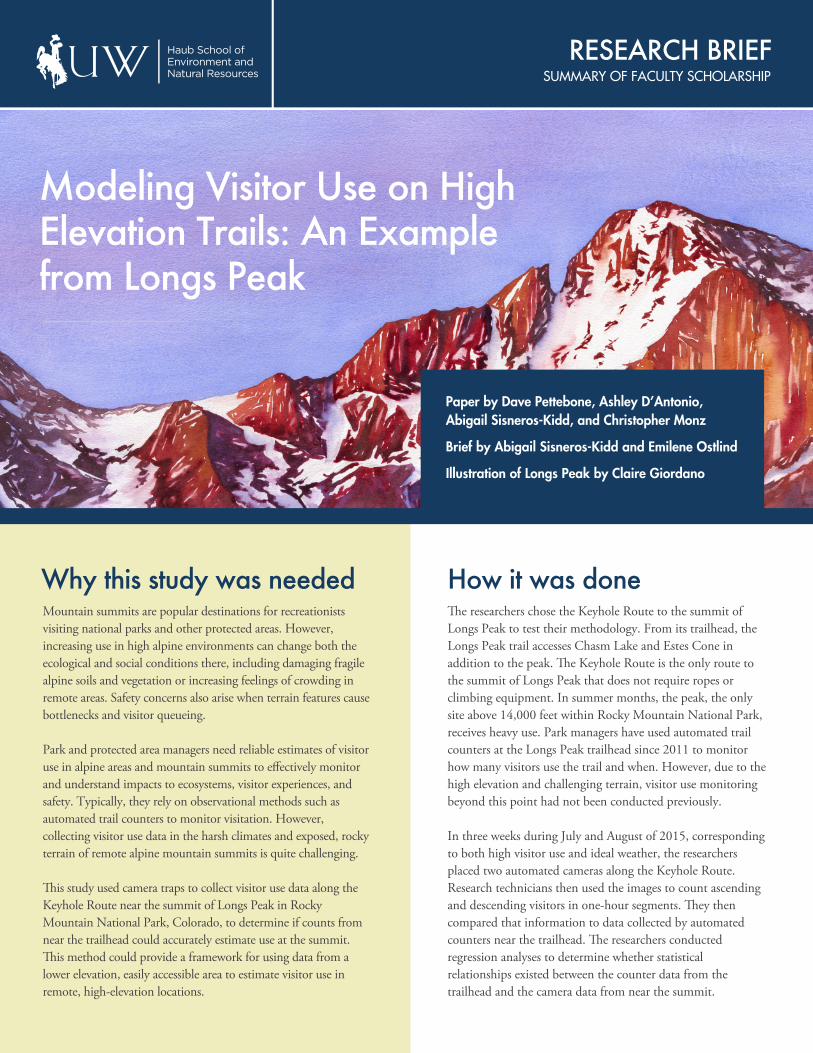
Importantly, counts from the trailhead predicted visitor use near the summit. For the Longs Peak Trail, ten additional people leaving the trailhead translated to about five reaching the summit on a given day and just more than one additional person on the summit during the hour of maximum use.
In addition, for every ten extra people who reached the summit on a given day, the number of people on the summit during the hour of maximum use increased by a little less than three on average. �ese relationships were statistically significant, meaning that visitor counts collected at the Longs Peak trailhead can accurately and reliably estimate levels of visitor use in more rugged, difficult to access, and remote stretches of the Keyhole Route near the summit of Longs Peak.
Why it's importantPark and protected area managers need information about visitor use on mountain summits to sustainably manage recreation in these areas. Knowing when the hour of peak visitation occurs can help schedule ranger patrols to increase contact with visitors and evaluate conditions during periods of high use. Collecting data in remote areas with rugged terrain can be costly in terms of equipment expenses as well as staff time. �is research provides managers with an analysis technique (discussed in detail in the paper) they can use to accurately estimate visitor use in remote or rugged locations based on data collected from trailheads.
About the authorsDave Pettebone, applied research coordinator, social science program, National Park Service
Ashley D'Antonio, assistant professor of nature-based recreation management, Department of Forest Ecosystems and Society, Oregon State University
Abigail Sisneros-Kidd, assistant professor of outdoor recreation and tourism management, Haub School of Environment and Natural Resources, University of Wyoming
Christopher Monz, professor of recreation resource management, Department of Environment and Society, Utah State University
Read the paperDave Pettenbone, Ashley D’Antonio, Abigail Sisneros-Kidd, and Christopher Monz, “Modeling visitor use on high elevation mountain trails: An example from Longs Peak in Rocky Mountain National Park, USA,” Journal of Mountain Science 16 (2019), https://doi.org/10.1007/s11629-019-5663-9
William D. Ruckelshaus Institute of Environment & Natural Resources
(307) 766-5080 | uwyo.edu/haub | [email protected]
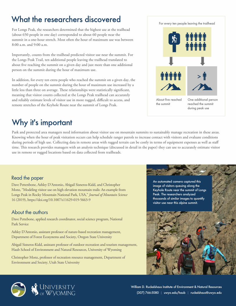
An automated camera captured this image of visitors queuing along the Keyhole Route near the summit of Longs Peak. The researchers analyzed thousands of similar images to quantify visitor use near this alpine summit.
For every ten people leaving the trailhead
About five reached the summit
One additional person reached the summit during peak use
>