Embed Size (px)
Citation preview
Environmental Review Guide – Selected Topics
1
Module V – Selected Topics
This module familiarizes reviewers with several project types by
identifying aspects of construction and operation/occupation that
may affect the natural environment. This module does not provide
details regarding environmental effects or mitigative actions. The
Environmental Review Guide addresses those topics in other
modules, particularly Module VII, “Impact Assessment
Methodologies.”
This module describes the following project types:
• Residential and shoreland development
• Airport development
• Highway construction
• Nonmetallic mineral mining
• Pipeline construction
• Wastewater systems
• Wind energy production and transmission
The Environmental Review Program protects and improves Minnesota’s water, biodiversity, and ecosystem services through the analysis of information requests, permit and license applications, and Minnesota Environmental Policy Act (MEPA) and National Environmental Policy Act (NEPA) documents. This module describes seven project types that are commonly reviewed by Minnesota Department of Natural Resources (DNR) staff. Refer to Module I, “Introduction to the Environmental Review Guide Project,” for a complete list of project types that are reviewed through the Minnesota Environmental Review Program.
Introduction
The mission of the DNR is to work with citizens to conserve and manage the state’s natural resources to provide outdoor recreation opportunities and to provide for commercial uses of natural resources in a way that creates a sustainable quality of life. The DNR encourages and promotes economic development that conserves and enhances environmental quality. The goal of the DNR Environmental Review Program is to establish a process that is straightforward, efficient, consistent, and effective in the protection of our natural resources now and for future generations while recognizing the need for sustainable development in the state. DNR involvement in environmental review ensures that environmental impacts are considered during the planning, construction, and post-construction phases of projects.
Environmental Review Guide – Selected Topics
2
The primary function of the Regional Environmental Assessment Ecologist (REAE) is to analyze the effects of human activity on natural systems. REAEs identify and describe the natural resources that could be affected by a proposed project, management activity, or plan and identify measures and recommend actions to avoid or minimize the negative impacts and maximize the positive impacts of that project, management activity, or plan. This module addresses seven project types: residential and shoreland development, airport
development, highway construction, nonmetallic mineral mining, pipeline construction,
wastewater treatment, and wind energy production and transmission. These seven types are representative of the full scope of projects that are carried out in the state. This guide may be revised in the future to describe other types as well. The common factor in all development projects is change to land cover, that is, alterations of the physical, chemical, and biological aspects of land and water, vegetation, soil, and artificial structures. Regardless of project type, there may be impacts on native plant communities, fish and wildlife, threatened or endangered species, water resources, public land, and many other valuable and critical natural resources. What this module says about the effects of one project type may be applicable to others as well.
Environmental Review Guide – Selected Topics
3
Selected Project Types
Residential and Shoreland Development
Residential development occurs in urban, suburban, and rural areas of the state and is a major contributor to the outward spread of cities, or urban sprawl, and the environmental problems it creates. Residential development can be as small as a single-family home or summer cabin or as large as a multiunit project covering several hundred acres and including streets, stormwater ponds, and open space. Small projects do not meet the threshold requirement for review under the state program. However, they may require licenses or permits that draw them to DNR attention. Regardless of size, residential projects have the potential to eliminate or fragment plant and animal habitat and discharge polluted runoff into lakes and streams. When project planning and design rely heavily on economic considerations, and the character of the landscape and the natural setting have value only in regard to the amenities they can provide to prospective homeowners, watershed health, ecological services, and biodiversity are the ultimate losers. The department reviews various types of residential development, from single to multiple units, and both attached and unattached. Lot size and housing density may vary, and units may be dispersed on the landscape or arranged in clusters. New residential developments not only require street construction but also may drive the need for new or improved highways to meet increased traffic demand. Potential impacts associated with residential development include habitat loss from land cover conversion, wetland alteration, changes to connectivity or patch size/distribution of natural areas/habitats, and stormwater management. Developers may characterize their projects as conservation developments, low-impact developments, conservation subdivisions, or planned unit development. Local governments typically regulate housing density (units per acre) through a zoning ordinance. Zoning ordinances often limit or eliminate mitigation options (e.g., incorporating through-streets in place of cul-de-sacs) that may be more environmentally benign than the proposed project. DNR staff may have to work carefully with local decision makers to gain acceptance of innovative strategies that protect natural resources. Potential environmental impacts from residential development include but are not limited to:
• Native plant communities: Clearing for lots and roads results in the permanent loss of native plant communities and their replacement with exotic species or less diverse communities. Residential developments fragment the remaining plant communities, greatly reducing their resilience and natural functions.
• Wildlife: The removal and fragmentation of plant communities leaves less habitat for wildlife. Species diversity declines, leaving residential areas populated only by the species that thrive in the presence of human activity. Often these are viewed as nuisance species.
Environmental Review Guide – Selected Topics
4
• Aquatic habitat: Shoreland development typically comes with a demand to remove lakeshore and in-lake vegetation. This results in a loss of critical habitat for fish, invertebrates, birds, and small mammals.
• Water quality: Runoff from streets, driveways, and yards adds nutrients and other chemical pollutants to lakes, wetlands, and streams. Even when managed to existing standards, stormwater runoff contributes to water quality decline. Additionally, the failure of septic systems is an all too common occurrence. (For more information about water quality impacts, see the “Wastewater Systems” section in this module.)
• Species in greatest conservation need (SGCN): Through land clearing, housing and road construction, landscaping, and other human activity, residential development results in habitat loss and degradation, the introduction and spread of invasive species, the pollution of land and water, persecution of certain species, disease, food source limitations, and roadkill. The State Wildlife Action Plan (SWAP) identifies these as the factors that create problems for SGCN.
• Public lands: Residential development often occurs adjacent to public land. Land-use conflicts arise when buffers are not established and maintained. Homeowners often encroach on public lands or object to legal uses of those lands, such as hunting and trapping. Runoff from streets and yards, exotic species and domestic animals, and trespass contribute to the erosion of the functions of public lands.
(For a list of residential development activities that affect natural resources, see the Impact
Checklist: Residential and Shoreland Development in Appendix A: Checklists.) Shoreland development is a special case of residential development. Lakeshore property ownership is a deeply ingrained cultural value in Minnesota, and shoreland development along lakes and rivers has accelerated during recent years. Residential development within the shore, bluff, and riparian impact zones not only directly affects the habitat quality of those zones but has a strong indirect and cumulative effect on lakes and streams. For lakes and streams, shoreline and nearshore areas are especially important ecologically. The general shoreland development issues are water quality, habitat, housing density, open space, surface water use, vegetation loss, shoreline armoring, building setbacks, and exotic invasive species.
The uncontrolled use of shorelands adversely affects the public health, safety, and general welfare by contributing to pollution of public waters and the impairment of natural resources and the local tax base. It is in the interest of present and future generations to preserve and protect the scenic, recreational, natural, historical, and scientific values of Minnesota public waters and their adjacent lands, including certain outstanding public waters. The Commissioner of Natural Resources provides minimum standards and criteria for the subdivision, use, and development of the shorelands of public waters. The standards and criteria are intended to preserve and enhance the quality of surface waters, conserve the economic and natural environmental values of shorelands, and provide for the wise use of water and related land resources of the state, as well as for the selection, classification, preservation, protection, management, and control of wild, scenic, and recreational rivers and their associated shorelands.
Environmental Review Guide – Selected Topics
5
Local governments are required to adopt land-use controls that are consistent with these purposes by limiting the direct and cumulative potential impacts of shoreland development on water quality, near-shore aquatic habitat, fish and wildlife habitat, scenic, recreational, natural, historical, and scientific values, and shoreland property values. The department’s goals are to protect, improve, and preserve shoreland area natural resources, specifically critical habitat and surface waters and groundwater. The SWAP identifies shorelands as important habitat for species in greatest conservation need. The Shoreland Management Program provides the backbone of statewide standards for the orderly development and protection of Minnesota’s shorelands (both rivers and lakes). DNR’s Division of Ecological and Water Resources provides technical assistance to local governmental units in the adoption and administration of their shoreland controls. This involves planning and zoning assistance to local governmental units by DNR Area Hydrologists and Shoreland Management staff. Guidance for protecting lake and stream water quality can be found in Minnesota’s Stormwater Management Manual on the Minnesota Pollution Control Agency website at www.pca.state.mn.us/water/stormwater/stormwater-manual.html. The DNR website includes information about the Shoreland Management Program.
Building design is another factor that affects natural resources, and an area in which DNR reviewers could encourage innovation. Passive solar design in new housing can reduce energy demand and CO2 emissions. Passive design includes taking maximum advantage of available sunlight by orientating as many dwellings as possible to solar south and by avoiding obstructions that block light from reaching windows. The greatest energy savings are achieved when passive solar design principles are applied to the design of the individual dwelling units. Passive solar design needs to be integrated with other design objectives of developments to ensure a balanced approach. South-facing elevations should not be overshadowed by other buildings or plantings, and higher buildings or taller trees should be located to the north of the site, along with car parking and garages.
Airport Development
An airport is a place where aircraft such as fix-winged planes and helicopters can take off and land. Airports are usually equipped with hangars for storage of aircraft, facilities for fueling and repair, and various accommodations for passengers. Airports consist of at least one surface such as a runway, a helipad, or water for takeoffs and landings. Smaller or less-developed airports often have a single runway shorter than 3,300 feet, while larger airports that support airline operations generally have paved runways 6,600 feet or longer. Many small airports have dirt, grass, or gravel runways, rather than asphalt or concrete.
The DNR reviews various airport development proposals. What separates one airport from another depends on the types of services it provides, the size aircraft it serves, the length of the runways, its terminal facilities, and its proximity to a densely populated area. There are seven basic types of airports:
Environmental Review Guide – Selected Topics
6
• Rural airstrip (a single narrow strip of grass or pavement)
• Private airstrip
• Military airport
• Small community airport
• Regional community airport
• Regional airport
• Major city airport
Airports may include parking lots, public transportation train stations, terminals, fuel tanks, access roads, runways, taxiways, and clear zones. Larger airports may require additional crosswind runways. Crosswind runways are a common feature of airports, but proposals for new crosswind runways can be problematic to address, as there are few standards to guide their layout. For example, there may be more flexibility for length and orientation (relative to the wind); airport managers, however, may propose an orientation that is optimal for takeoffs but does not avoid important habitats. There may be visual aids available to pilots, though not all airports are equipped with them. Approach lighting may extend well beyond the approach end of the runway. Airports also have clear zones and safety zones around their perimeters. Safety zoning may extend well beyond an airport’s perimeter, affecting any object, including trees that might be considered a hazard to airport operations. The management of wildlife activity in these areas is an issue for the DNR to consider. For example, large trees across the Mississippi River from St. Paul’s Holman Field are potential nesting sites for bald eagles but also present a hazard to planes taking off and landing. Aircraft noise not only occurs from takeoff and landings but also from ground operations including maintenance and testing of aircraft. Aircraft noise can disturb animals living near airports. Birds in the air and large animals on the runway can cause damage to aircraft and injury and death to pilots and passengers. According to the Federal Aviation Administration, birds make up 97% of reported collisions with aircraft, mammals about 3%, and reptiles less than 1%. The FAA treats the management of wildlife on and near airports as a complex problem. Management can range from habitat manipulation, to the use of predators, to repelling wildlife, to lethal control of wildlife. Due to the risk of collision between birds and airplanes, large airports manage plant communities to discourage birds and mammals, and undertake population control programs through which they frighten or shoot birds. The conversion of natural land cover to mowed grasses may only replace one group of hazardous wildlife with another. For example, filling wetlands may rid the area of ducks and blackbirds but create lawn-like conditions that attract geese, gulls, grackles, and cowbirds. Sometimes the hazard may be periodic, caused by migrating birds that are in the area only for a short time. Airport construction generally converts pervious surfaces to pavement and structures, often changing drainage patterns, leading to more flooding runoff and erosion in the surrounding land.
Environmental Review Guide – Selected Topics
7
Operations at larger airports may involve the deicing of aircraft and snow removal on runways and access roads, which contributes contaminants to wetlands, streams, and groundwater systems.
Highway Construction
The DNR reviews proposals for new highway segments as well as upgrades and expansions of existing highways. The Minnesota Department of Transportation (Mn/DOT) and county highway departments are the primary project proposers. Mn/DOT has well-defined procedures for planning, constructing, and maintaining highways. Highway projects that are funded in part with federal monies may be subject to review under the NEPA and require the development of an Environmental Assessment (EA) or Environmental Impact Statement (EIS).
Simply put, a highway is a main road for travel between important destinations, such as cities and states. This category also includes streets and thoroughfares within cities, and county and township roads. Highway designs vary widely and can range from a two-lane road without margins to a multilane, grade-separated motorway, and may include features for pedestrian and bicycle use. Highway development consists of four activity phases: planning, design, construction, and operation. Decisions and actions during each of these phases may affect natural resources. For example, in the planning stage, highway authorities consider the need for a project, possible transportation alternatives, potential highway corridors, and basic designs. It is during planning that DNR reviewers can most effectively influence decisions to avoid fragmenting landscape-level habitats and natural communities. The USEPA report Evaluation of Ecological Impacts from Highway Development (1994) is an excellent reference document for use by highway project reviewers. The following information is from that report, and the entire report is included with this Guide. Also, note that the state and county highway planning processes differ. The DNR therefore approaches county highway planning differently from state planning. In general, counties develop annual work plans. Regular communication between the DNR and counties helps ensure that natural resource concerns are considered during the planning phase. The planning phase involves all pre-design activities including the siting of the highway corridor. This phase considers the purpose and need for a project, transportation options, potential locations, and possible basic designs. In effect, the planning phase determines the areas (and sensitive habitats) to be affected by selecting the corridor route. Planning also includes the selection of the highway type, basic configuration, and number of interchanges. Direct and indirect effects are both determined in this phase. Environmental objectives should be clearly outlined during the planning phase. The design phase involves the siting of the final right-of-way footprint and all aspects of structural design and design mitigations. By selecting such highway parameters as width, slope, side slopes, total right-of-way width, and type of crossing structures, this phase determines the specific potential impacts on adjacent and nearby ecosystems. While planning determines the general areas where habitat will be destroyed or degraded (areas within the highway corridor),
Environmental Review Guide – Selected Topics
8
the design phase specifies which locations will be affected or avoided. For this reason, small-scale mitigations, such as the provision of animal travel corridors and crossings, are most important in the design phase. Also at this stage, use of tools such as Natural Preservation Route designation, can mitigate impacts throughout the project corridor. The construction phase involves vegetation removal, earth moving, and road building activities that physically impact sensitive habitats. Although the habitats to be affected and the types of impacts are already determined by the preceding phases, the specific operation of construction activities may determine the severity of impacts such as erosion and disturbance. While vegetation removal is inherent within the roadway footprint, excessive vegetation clearing, for example, for work zone or staging and material storage areas, can be eliminated. In addition to physical destruction of habitat within the footprint, soil erosion and other forms of pollution are the primary impacts in this phase. Mitigations involving both the timing and performance of these activities can dramatically reduce these adverse impacts. The operation and maintenance phase includes all post-construction activities associated with the built project, including routine vehicle traffic, roadway and drainage ditch maintenance, and accidents and spills. Routine maintenance activities include roadway paving and patching; roadside blading and litter collection; vegetation management (including mowing, chemical control, planting, seeding, and fertilizing); cleaning, painting, and repair of roadside structures (including curbs, drains, guardrails, and signs); street cleaning; snow removal; deicing (application of salt, sand, and other materials); lighting; abrasives; pavement marking; equipment cleaning; and hazardous material handling and storage. Although similar in nature to construction impacts, the pollution effects of this phase are long-term. The main natural resource impacts during this phase are surface water and groundwater contamination, vegetation damage, and wildlife mortality. Best management practices are the principal mitigation measures for these impacts. Highways are an example of disturbance corridors that disrupt natural landscapes. Highway systems introduce discontinuities into natural communities; destroy the structure and function of natural communities; stress wildlife that must negotiate, tolerate, and cope with difficult barriers; provide conditions favorable to invasive plants; cut off portions of watersheds; and eliminate nesting habitat for forest-interior species. Highways also can induce the commercial, industrial, and residential development that contributes to cumulative impacts.
Nonmetallic Mineral Mining
The Division of Lands and Minerals manages the state’s mineral resources and manages mine development on state-owned and tax-forfeited lands. The department’s goal is to ensure that mineral development is environmentally sound, and mined areas are reclaimed to be safe, free of pollution, and suitable for future use. The regions are responsible for reviewing proposed nonmetallic mineral mines. About 11,000 years ago, glaciers covered most of Minnesota. These glaciers left behind large amounts of sand and gravel. There are sand, gravel, and aggregate mining operations in nearly every county in Minnesota. Sand and gravel are necessary in the making of concrete and bituminous material for the construction of highways, roads, bridges, and many buildings. Sand
Environmental Review Guide – Selected Topics
9
is also used along with salt to melt ice on roads and to provide better traction in the snow. Silica sand is very fine sand composed of quartz (a white to colorless mineral) and is mined in the southeastern part of Minnesota. It is used to make glass, is a source of silicon, and is used in oil drilling to improve the flow of oil to wells. Granite and limestone are used in the construction of homes, buildings, roads, and tombstones. These rocks are often mined in large blocks from a quarry. Granite or limestone mined this way is called dimension stone. Rock outcrops often harbor unique or unusual plant communities, particularly where vernal pools form. Reviewers of quarry proposals should pay particular attention to plant communities on these project sites. Clay is mined in the Minnesota River valley. Clay is used in making bricks, porcelain, tiles, and medicines. Companies are currently exploring Minnesota for higher-grade kaolin clay, which is a fine, white clay used to add a glossy look to paper. Kaolin mines in the New Ulm area contain some of the oldest angiosperm fossils; mining potentially destroys these rare features along with opportunities for scientific research. Peat is formed by partially decomposing plant material in wet environments, such as bogs or fens, where more plant material is produced than is decomposed. Peat is the beginning of the fossilization of the plants. Peat is used mainly in the gardening industry, but it is also used for compost, turkey litter, absorbing oil, and fuel. Peat mining can result in impacts to areas of biodiversity significance and discharges with elevated levels of mercury. (For information about the biological significance of Minnesota’s peatlands, see the biodiversity section in Module III, “Water, Ecosystem Services, and Biodiversity.”) These materials typically are obtained by open-pit mining, also known as open-cast, open-cut, or strip mining. Open-pit mines are used when deposits of commercially useful minerals or rock are found near the surface and where the overburden (surface material covering the marketable material deposit) is relatively thin. Open pits that produce building materials such as limestone are commonly referred to as quarries. Open-pit mines are typically enlarged until either the mineral resource is exhausted or further mining becomes uneconomical. When this occurs, the exhausted mines are sometimes converted to landfills for disposal of solid wastes or to demolition debris landfills. Mined-out areas may also be reclaimed for conversion to residential or commercial development or to parkland. However, some form of water control may be required to keep the mine pit from becoming a lake. In some cases, local communities choose to allow the pit to flood and manage it as a recreational amenity. Open-pit mining utilizes large mechanical equipment to remove the commercial material and waste from the open pit. The amount of equipment and its type and size depend on the characteristics of the material and waste and the required production capacity. In general, there are four basic operations common to most open-pit mining operations: drilling, blasting, loading, and hauling. Waste material that is generated during the course of mining is typically stockpiled on-site for later use in the reclamation stage. Three types of waste material are generated at most mining operations: overburden from the mine, the fine sands washed out during processing, and dust.
Environmental Review Guide – Selected Topics
10
Applications for water appropriations may be associated with sand or gravel mining. Such appropriations, whether to wash materials or dewater mines, may draw down water levels in nearby wetlands, especially calcareous fens. If a mine is hydrologically upgradient from a calcareous fen, the DNR recommends that mining should go no deeper than 1 foot above the groundwater table. Groundwater should not be exposed. In addition, the discharge of appropriated water may result in water-quality impacts or increased flow in receiving waters. Site reclamation should be required as part of the mining plan. This typically focuses on a defined end use, for example, residential or commercial development. This should not be confused with site restoration, which is not possible once the underlying material has been removed and the topography has been altered. Sand and gravel mining often occurs in the alluvial deposits of floodplains, but proposals for mining in active river channels are rare (the Aggregate Industries proposal to mine in the Mississippi River being the notable exception). Active channel deposits are often of suitable quality to be used in cement because the gravels are well sorted, with unstable fragments having been eliminated by abrasion in river transport. Moreover, river deposits are often located near markets for the product, minimizing transport costs, which are the largest costs in the industry. Mining in active river channels typically results in incision upstream of the mine (by knickpoint migration) and downstream (by sediment starvation). Incision may cause undermining of structures, lowering of alluvial water tables, channel destabilization and widening, and loss of aquatic and riparian habitat. Floodplain gravel pits have the potential to become good wildlife habitat upon reclamation, provided that margins are appropriately contoured and water table fluctuations are not excessive. During floods, the river channel may come to occupy a course through floodplain gravel pits, resulting in pit capture and the transformation of floodplain pits to in-channel pits.
Pipeline Construction
Petroleum pipelines are part of a vast national and international network that includes oil and gas fields, ports, refineries, and the pipelines themselves. This complex network has many sources, destinations, and interconnections. A proposed pipeline, whether short or long, will be characterized by the nature of the network. Pipelines, like other linear systems, such as highways and transmission lines, have endpoints that drive decisions about location, design, and construction approaches all along the length of the project. Because pipelines may cross several ECS subsections and multiple vegetative communities, it is crucial that the DNR becomes involved in the decision-making process as early as possible. In the United States, long-distance pipelines are owned by pipeline companies whose only function is to operate the pipeline system. Pipeline construction is usually done by a construction contractor rather than by the pipeline owner. The contractor hires firms that provide specialized services such as pipe coating, maintenance, and inspection. Most petroleum pipeline projects reviewed by the DNR are trunk lines that move crude oil from the producing areas to refineries in Minnesota or other midwestern states. The opening of the Canadian tar sands oil fields has spurred large-diameter, long-distance pipeline construction in the state. Crude trunk lines come in a variety of pipe sizes and require pumps and pumping
Environmental Review Guide – Selected Topics
11
stations along the lines to keep the oil moving. The pipes are made of steel and are buried underground. The construction of pipelines follows a sequence of design and route selection, obtaining rights-of-way, obtaining permits and licenses, installation, tie-in to origin and destination facilities, and testing. The DNR may be involved at all of these stages. Because of the size and complexity of these systems, DNR review is extremely important, and close attention to details at all stages is critical. As with large highway projects, decisions made during the planning and siting stages determine the corridor and the resources that will be affected within that corridor. From the company’s perspective, the most economical corridor is a straight one. The company, however, has to consider the crossing of private and public lands, along with the difficulties of traversing steep slopes, areas of bedrock, and landscape features such as streams, wetlands, and highways. Environmental issues related to pipelines include permanent vegetation management in the disturbed corridor, staging areas, disturbance to DNR lands, water crossings, listed species, erosion control, water-quality impacts, mussels (or other aquatic fauna), and seasonal timing at water body crossings. When designing a pipeline, the pipeline company considers installation costs and the expense of operation and maintenance. In making the cost determination, the company needs to know which natural resources to avoid and what compensation the natural resource agencies will require for the resource losses. Typically, the pipeline company hires a consulting firm to carry out the work of siting the pipeline, which includes meetings and discussion with the resource agencies. The consultant plots the proposed route on aerial photographs and should make these photos available to the resource agencies. The width of the right-of-way varies according to the line size, type of terrain, construction method to be used, and any special restrictions. The right-of-way must be wide enough to accommodate the pipeline ditch, the storage of excavated material, and a working area for construction equipment. The crossing of streams and major rivers and railroads and highways requires extra work space. The installation of the pipe includes the following steps:
1. Clearing the right-of-way of vegetation is accomplished with bladed or logging equipment, depending on the community type. This makes it possible for construction equipment to move along the right-of-way.
2. Ditching occurs on one side of the center line, and excavated soils are deposited on the side of the ditch closest to the edge of the right-of-way. Soil horizons should be segregated so that the layers can be returned to the ditch in the proper order. Excavation during freezing or wet conditions can make soil segregation difficult.
3. Stringing pipe sections along the right-of-way involves delivering pipe sections on trucks and placing it where it can be moved readily to the ditch and welded to the pipeline.
4. Welding the pipe sections together is typically done with welding machines mounted on small trucks. A bending machine makes bends in the pipeline to accommodate changes in direction or elevation.
5. The exterior of the pipe is coated or wrapped to protect it from corrosion and abrasion. In some cases, this is done before the pipe is delivered to the job site.
Environmental Review Guide – Selected Topics
12
6. A gang of sideboom tractors gradually lower the pipeline into the ditch. 7. The ditch is backfilled with the excavated material. 8. The line is hydrostatically tested for leaks. At the end of this process, the water is filtered
before being discharged. 9. To reclaim the environmentally impacted area, the right-of-way is given a final grading and
seeded. Erosion control devices should remain in place until vegetation has become adequately established.
(Note: Details of construction methods are available in “Overview of the Design, Construction and Operation of Interstate Liquid Petroleum Pipelines.” This document covers all aspects of pipeline design, construction, and maintenance. In addition, the Minnesota Public Utility Commission document Environmental Assessment Supplement to the Pipeline Routing Permit
Application, MinnCan Project contains a substantial amount of useful information about the pipeline installation process, including graphics.) Road and river crossings are a major pipeline construction activity. Crossing methods include several ditching approaches, boring, and drilling. The ditching of streams can result in erosion and sedimentation, and in some cases, for example, large rivers or streams that provide important habitat for game fish and rare aquatic species, may not be permitted. Boring is a method generally used for crossing under roadways, but it can also be used at streams. Horizontal directional drilling (HDD) has emerged as the preferred method for crossing roadways and most streams. The advantage of HDD is minimal environmental impact. However, HDD has some problems, such as the potential for drilling mud to escape to the surface through fractures in the bedrock or weak points in the overlaying soil. Pipeline companies should have a drilling mud containment, response, and notification plan so that they know how to respond quickly in the event of a “frac-out.” Potential environmental impacts from pipeline construction and operation include:
• Geology and soils: Pipelines may cross through areas of unstable soils, steep or rocky terrain, or bedrock. Erosion and sedimentation are concerns, along with the mixing of soil horizons. Fuel and hydraulic fluid contamination of soils during construction is a very real possibility, and a break in a functioning pipeline can quickly contaminate a large area. Preparation and quick response are two important elements in the management of a pipeline.
• Public lands: The crossing of public lands can affect natural communities, habitat, and the quality of recreational experiences. Parcels such as wildlife management areas and waterfowl production areas usually can be avoided.
• Vegetation: Clearing the right-of-way and work areas of vegetation can have short-term and long-term consequences. Restoration should be a requirement of the permit, but generally a full restoration is not possible. High-quality and high-value natural communities should be avoided.
• Wildlife: Pipeline construction results in the loss and fragmentation of wildlife habitat. The pipelines themselves do not impair the movement of species along migration corridors. Cleared and maintained rights-of-way, however, create barriers to movement
Environmental Review Guide – Selected Topics
13
for many species, give advantage to predators, and encourage the spread of invasive species. Special wildlife areas, such as rookeries and wildlife management areas, should be avoided.
• Fisheries: Pipelines cross perennial and intermittent streams, cold-water and warm-water streams, and designated trout streams and may affect high-quality or high-value fisheries. Erosion and sedimentation, resulting from construction activities, impair water quality. Close attention needs to be paid to the crossing techniques to be used.
• Species in greatest conservation need (SGCN): Major pipeline projects will cross more than one ECS subsection and have the potential to affect many SGCN and their habitat. The PUC permitting process requires that pipeline companies review the Natural Heritage Information System for the presence of threatened and endangered species and other rare elements. DNR reviewers should check the SWAP and expand the review to other SGCN.
• Groundwater and surface water: Fuel and hydraulic spills, which are common on pipeline construction projects, have potential to contaminate groundwater and surface water. Pipeline companies should require their contractors to report and clean up all spills, no matter how small.
While the focus of environmental review is on pipeline construction, the pipeline will remain a potential hazard throughout its useful life. Out of sight, breaks in the line can go unnoticed until the pipe’s contents rise to the surface or emerge in waterways. Cleanup can be difficult and costly. Pipeline companies try to avoid emergencies by monitoring pipeline conditions and repairing damaged sections before breaks occur. During their review of proposed projects, DNR reviewers should consider the consequences of a future break in a wetland or near another valued resource.
Wastewater Systems
Municipal wastewater that is generated by industry and most residential development in Minnesota’s cities is carried through municipal sanitary sewer pipes to wastewater treatment plants. Wastewater treatment and disposal are an important part of the effort to protect and preserve Minnesota’s water resources. The Minnesota Pollution Control Agency (MPCA) is the lead agency in wastewater treatment facility permitting, and the DNR provides valuable information about natural resources that might be affected by these facilities. The DNR provides early coordination and comment on sanitary sewer and wastewater treatment systems. The DNR’s purpose in reviewing wastewater treatment systems is to avoid degrading the water quality of receiving waters. The MPCA uses nondegradation as a tool to protect surface waters from significant degradation and to maintain existing water uses. Minnesota Rules, parts 7050.0180 and 7050.0185, deal with nondegradation, applying the concept to both outstanding resource value waters (ORVW) and non-ORVW. ORVW get special protection because of their exceptional recreational, cultural, aesthetic, or scientific value. Along with bacteria and other pathogenic (disease-causing) organisms, untreated sewage contains significant levels of nutrients that can hasten the “aging” of water bodies, or eutrophication. These nutrients enhance the growth of algae and other aquatic plants and result in
Environmental Review Guide – Selected Topics
14
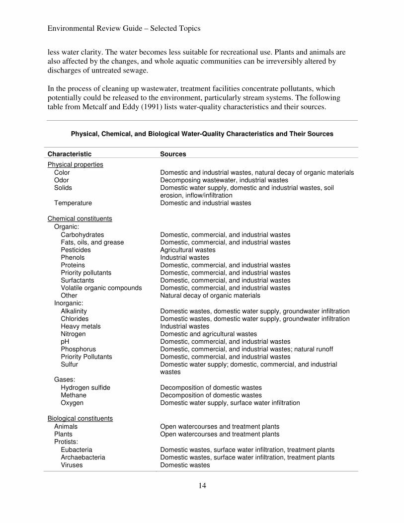
less water clarity. The water becomes less suitable for recreational use. Plants and animals are also affected by the changes, and whole aquatic communities can be irreversibly altered by discharges of untreated sewage. In the process of cleaning up wastewater, treatment facilities concentrate pollutants, which potentially could be released to the environment, particularly stream systems. The following table from Metcalf and Eddy (1991) lists water-quality characteristics and their sources.
Physical, Chemical, and Biological Water-Quality Characteristics and Their Sources
Characteristic Sources
Physical properties
Color Domestic and industrial wastes, natural decay of organic materials
Odor Decomposing wastewater, industrial wastes
Solids Domestic water supply, domestic and industrial wastes, soil erosion, inflow/infiltration
Temperature Domestic and industrial wastes
Chemical constituents
Organic:
Carbohydrates Domestic, commercial, and industrial wastes
Fats, oils, and grease Domestic, commercial, and industrial wastes
Pesticides Agricultural wastes
Phenols Industrial wastes
Proteins Domestic, commercial, and industrial wastes
Priority pollutants Domestic, commercial, and industrial wastes
Surfactants Domestic, commercial, and industrial wastes
Volatile organic compounds Domestic, commercial, and industrial wastes
Other Natural decay of organic materials
Inorganic:
Alkalinity Domestic wastes, domestic water supply, groundwater infiltration
Chlorides Domestic wastes, domestic water supply, groundwater infiltration
Heavy metals Industrial wastes
Nitrogen Domestic and agricultural wastes
pH Domestic, commercial, and industrial wastes
Phosphorus Domestic, commercial, and industrial wastes; natural runoff Priority Pollutants Domestic, commercial, and industrial wastes
Sulfur Domestic water supply; domestic, commercial, and industrial wastes
Gases:
Hydrogen sulfide Decomposition of domestic wastes
Methane Decomposition of domestic wastes
Oxygen Domestic water supply, surface water infiltration
Biological constituents
Animals Open watercourses and treatment plants
Plants Open watercourses and treatment plants
Protists:
Eubacteria Domestic wastes, surface water infiltration, treatment plants
Archaebacteria Domestic wastes, surface water infiltration, treatment plants
Viruses Domestic wastes
Environmental Review Guide – Selected Topics
15
Wastewater collection and treatment systems include the following:
• Subsurface sewage treatment (septic) systems: These are soil-based treatment systems used by homes and businesses that are not connected to municipal sewer. Their purpose is to treat and dispose of the wastewater generated on-site. A typical septic system has four main components: a pipe from the home, a septic tank, a drainfield, and the soil. Microbes in the soil digest or remove most contaminants from wastewater before it eventually reaches groundwater.
• Mound systems: These are soil treatment systems with rock beds elevated above the original soil with clean sand to overcome soil limitations.
• Holding tank: This consists of a tank for storage of sewage until it can be transported to a permitted wastewater treatment system for treatment and disposal.
• Permitted wastewater treatment system: This industrial-scale system consists of networks of sewer pipes connecting homes and businesses to a centralized wastewater treatment plant.
• Urban sewer systems: These are community sewer systems that are completely gravity-powered. Pipes from each sewage source connect to a sewer main that runs, for example, down the middle of the street. The sewer mains flow into progressively larger pipes until they reach the wastewater treatment plant. To help gravity do its job, the wastewater treatment plant is usually located in a low-lying area. Normally, the terrain works against the system, and gravity cannot do all the work. In these cases, the sewer system will include a lift station to move the wastewater up over a hill.
The review of residential developments typically includes information about individual or community collection systems. The pollution of nearby groundwater and surface waters is usually the main concern with these systems. Trunk sewer systems, the larger diameter pipelines that transport sewage over relatively long distances, are usually reviewed as stand-alone projects. These are linear projects that require temporary disruptions of vegetation and soil. By placing these pipelines in the middle of streets or in rights-of-way, communities can minimize environmental impacts. Activities that can affect natural resources include:
• treatment and collection systems
• physical/chemical treatment
• wastewater reuse
• decentralized/on-site systems
• stormwater management
• biological treatment processes
• advanced treatment processes
• biosolids treatment technology
Environmental Review Guide – Selected Topics
16
• combined sewer overflows
• constructed wetlands
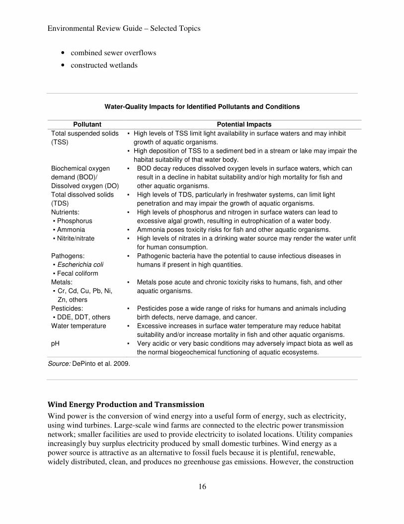
Water-Quality Impacts for Identified Pollutants and Conditions
Pollutant Potential Impacts
Total suspended solids
(TSS)
▪ High levels of TSS limit light availability in surface waters and may inhibit
growth of aquatic organisms.
▪ High deposition of TSS to a sediment bed in a stream or lake may impair the
habitat suitability of that water body.
Biochemical oxygen
demand (BOD)/
Dissolved oxygen (DO)
▪ BOD decay reduces dissolved oxygen levels in surface waters, which can
result in a decline in habitat suitability and/or high mortality for fish and
other aquatic organisms.
Total dissolved solids
(TDS)
▪ High levels of TDS, particularly in freshwater systems, can limit light
penetration and may impair the growth of aquatic organisms.
Nutrients:
▪ Phosphorus
▪ Ammonia
▪ Nitrite/nitrate
▪ High levels of phosphorus and nitrogen in surface waters can lead to
excessive algal growth, resulting in eutrophication of a water body.
▪ Ammonia poses toxicity risks for fish and other aquatic organisms.
▪ High levels of nitrates in a drinking water source may render the water unfit
for human consumption.
Pathogens:
▪ Escherichia coli
▪ Fecal coliform
▪ Pathogenic bacteria have the potential to cause infectious diseases in
humans if present in high quantities.
Metals:
▪ Cr, Cd, Cu, Pb, Ni,
Zn, others
▪ Metals pose acute and chronic toxicity risks to humans, fish, and other
aquatic organisms.
Pesticides:
▪ DDE, DDT, others
▪ Pesticides pose a wide range of risks for humans and animals including
birth defects, nerve damage, and cancer.
Water temperature ▪ Excessive increases in surface water temperature may reduce habitat
suitability and/or increase mortality in fish and other aquatic organisms.
pH ▪ Very acidic or very basic conditions may adversely impact biota as well as
the normal biogeochemical functioning of aquatic ecosystems.
Source: DePinto et al. 2009.
Wind Energy Production and Transmission
Wind power is the conversion of wind energy into a useful form of energy, such as electricity, using wind turbines. Large-scale wind farms are connected to the electric power transmission network; smaller facilities are used to provide electricity to isolated locations. Utility companies increasingly buy surplus electricity produced by small domestic turbines. Wind energy as a power source is attractive as an alternative to fossil fuels because it is plentiful, renewable, widely distributed, clean, and produces no greenhouse gas emissions. However, the construction
Environmental Review Guide – Selected Topics
17
of wind farms is not universally welcomed, because of their visual impact and other effects on the environment. Small-scale wind power is the name given to wind-generation systems with the capacity to produce up to 50 kW of electrical power. Isolated communities that may otherwise rely on diesel generators may use wind turbines to displace diesel fuel consumption. Individuals may purchase these systems to reduce or eliminate their dependence on grid electricity for economic or other reasons, or to reduce their carbon footprint. Wind turbines have been used for household electricity generation in conjunction with battery storage for many decades in remote areas. Large Wind Energy Conversion Systems (LWECS) can range from 5 MW to over 500 MW, and the turbine layout combined with access roads, collector/transmission lines, and substations can be located over very large areas depending on project size, wind resources, and other factors. Many effects of wind energy development on wildlife in Minnesota are still not well understood. Efforts are underway to gain a better understanding of these effects to help plan for sustainable wind energy development. A federal advisory committee has reached consensus on Wind Turbine Guideline Recommendations. The recommendations from this multi stakeholder effort are the most current and comprehensive guideline recommendations available. Like all mechanical systems, wind turbines produce some noise when they operate. Most of the turbine noise is masked by the sound of the wind itself, and the turbines run only when the wind blows. In recent years, engineers have made design changes to reduce the noise from wind turbines. Early model turbines are generally noisier than most new and larger models. As wind turbines have become more efficient, more of the wind is converted into rotational torque and less into acoustic noise. Additionally, proper siting and insulating materials can be used to minimize noise impacts. Because they must generally be sited in exposed places, wind turbines are often highly visible; however, being visible is not necessarily the same as being intrusive. Aesthetic issues are by their nature highly subjective. Proper siting decisions can help to avoid any aesthetic impacts to the landscape. One strategy being used to partially offset visual impacts is to site fewer turbines in any one location and to use today’s larger and more efficient models of wind turbines. Biological issues include, but are not limited to, the following:
• Direct mortality of birds and bats: curtailment (having a higher wind speed at which turbines start rotating) has been shown in other states to alleviate most bat mortalities.
• Displacement: some bird species have been shown to avoid nesting in the vicinity of turbines; given the limited amount of high-quality grassland habitat that is available for nesting, displacement has a potentially larger impact on populations than does mortality.
• Avoidance of turbine areas by waterfowl can result in loss of traditional feeding and use areas.
• Habitat fragmentation can occur from the footprint of turbines as well as associated development.
Environmental Review Guide – Selected Topics
18
• Invasive species maybe brought into areas by construction equipment from other sites/areas of the country.
Natural resource concerns vary somewhat with region: In northeastern Minnesota, siting of wind turbines in the North Shore highlands could endanger a major migration corridor. In southeastern Minnesota, karst geology makes siting precarious and raises the risk of groundwater contamination.
Bird and bat deaths are one of the most controversial biological issues related to wind turbines. Fish and wildlife agencies and conservation groups have raised concerns about the deaths of birds and bats at wind farm sites. On the other hand, several large wind facilities have operated for years with only minor impacts on these animals. To address this issue, the wind industry and government agencies have sponsored research into collisions, relevant bird and bat behavior, mitigation measures, and appropriate study design protocols. In addition, project developers are required to collect data through monitoring at existing and proposed wind energy sites. Careful site selection is needed to minimize fatalities, and in some cases additional research may be needed to address impacts on birds and bats. Unlike most other generation technologies, wind turbines do not use combustion to generate electricity, and hence do not produce air emissions. The only potentially toxic or hazardous materials used are relatively small amounts of lubricating oils and hydraulic and insulating fluids. Therefore, contamination of surface waters, groundwater, or soils is highly unlikely. The primary health and safety considerations are related to blade movement and the presence of industrial equipment in areas potentially accessible to the public. An additional concern associated with wind turbines is potential interference with radar and telecommunication facilities. And like all electrical generating facilities, wind generators produce electric and magnetic fields. The Minnesota Department of Commerce, Office of Energy Security handles the siting and permitting of large-scale wind farms in the state. The DNR has drafted guidance for reviewing wind energy projects: Guidance for Wind Energy Projects (Draft, June 2010). In addition to the turbines, reviewers must consider the potential impacts of associated transmission lines. These lines, which may be several miles in length, are necessary to convey electricity from the wind farm to existing transmission lines. Potential impacts include:
• Noise: Construction noise is likely minimal and short-term. Long-term noise emitted by the transmission line and substations also is minimal.
• Aesthetics: Visual impacts can be minimized by constructing lines in or adjacent to existing roadways. Lines can be masked by trees.
• Recreation: Transmission lines may cross parks and trails, visually affecting those facilities. While parks can be avoided, the avoidance of linear elements such as trails is difficult. Ice throw from turbine blades can be hazardous if towers are located too close to parks or trails.
Environmental Review Guide – Selected Topics
19
• Forestry: The clearing of transmission line rights-of-way may entail the removal of significant numbers of economically valuable trees. Project proposers should work with area foresters to make the best use of these trees.
• Water quality: Transmission lines may cross surface water, floodplains, or groundwater recharge areas. Impacts may result from the placement of poles or towers and stormwater drainage.
• Wetlands: The crossing of wetlands can have both short-term and long-term impacts. Efforts should be made to minimally impact soils, vegetation, and hydrology.
• Vegetation: Transmission line right-of-way maintenance requires periodic vegetation management. This may include cutting and herbicide use.
• Wildlife: Bird and bat strikes are of particular interest with energy projects. During the planning process, the project proposer should conduct surveys to determine the species and numbers of animals that use the project area. The elimination or fragmentation of animal habitat can be an issue with these projects.
• Rare and unique natural resources: During the planning process, the project proposer should query the Natural Heritage Information System to determine the presence of rare, endangered, and otherwise unique natural elements.
Environmental Review Guide – Selected Topics
20
Impacts and Mitigation
This module provides only a minimal discussion of natural resource impacts and mitigation for those impacts. For more detail about natural resources, see Module III, “Water, Ecosystem Services, and Biodiversity.” For impact assessment, see Module VII, “Impact Assessment Methodologies” and the checklist for each project type.
The causes of the decline of populations of native species, both common and rare, are habitat loss, habitat degradation, invasive species, pollution, social intolerance, disease, and food source limitations. Habitat loss and habitat degradation are by far the two leading problems for species in the state. All proposed development activities have the potential to contribute to habitat loss or degradation. As the state’s population continues to grow, more habitat will be converted to other cover types, placing further pressure on natural resources. That, coupled with climate change, will make resource conservation much more difficult. The general mitigation sequence for all project types is to avoid impacts, minimize those impacts that cannot be avoided, and then provide compensation for lost functions and values. Approaches to be considered include the following:
• No-build: For most project proposals, this is simply not an option. Occasionally a proposer will abandon a project, usually for economic reasons, but most projects will be completed in one form or another. In the federal and state review programs, the no-build alternative is a baseline condition against which other alternatives are compared.
• Project modification: Recommend changes to project configurations, such as the number, location, or size of structures or the alignment of highways and pipelines. Also encourage select grading, rather than mass grading of development sites; the use of ponds for stormwater management, rather than existing wetlands; the installation of permeable surfaces for driveways and parking lots; and directional lighting and other green design features.
• Construction timing: Schedule construction activities to avoid migration, nesting, and fish spawning periods, peak oak wilt infestation periods, and other times when critical biological activities occur. Operational timing (diel or seasonal) can also be a way to reduce impacts.
• Buffer natural resource areas: Establish and preserve vegetated buffers between disturbed areas and valued natural resources. Include covenants or permanent monuments to help minimize encroachment into the buffer.
• Replace natural resource functions on-site: On-site mitigation generally compensates for locally important functions and should therefore be given priority over off-site mitigation. Where practicable, mitigation should be carried out in areas adjacent or contiguous to the affected site.
• Replace natural resource functions off-site: Off-site mitigation can be used where there are no practicable on-site opportunities, or if off-site mitigation would provide more benefit than mitigation on-site.
Environmental Review Guide – Selected Topics
21
• Conservation easements: A conservation easement is a voluntary agreement that allows a landowner to limit the type or amount of development on their property while retaining private ownership of the land. The easement is signed by the landowner, who is the easement donor, and the party receiving the easement. The receiving party accepts the easement with the understanding that it must enforce the terms of the easement in perpetuity. After the easement is signed, it is recorded with the county and applies to all future owners of the land.
• Payments to a conservation fund: For example, concerned about the rapid growth in the county, Dakota County citizens passed a $20 million bond referendum in 2002. The funds are used to purchase development rights and establish permanent farmland and natural areas easements. The Dakota County Farmland and Natural Areas Program (FNAP) is a voluntary program in which Dakota County and other partners work with willing landowners to achieve mutual land protection and natural resource stewardship goals through the acquisition of conservation easements or fee title. The overall goal of the program is to protect large, contiguous, agricultural areas, while providing water-quality and wildlife habitat benefits, and to protect, connect, and manage priority natural areas.
• Resource inventory: A natural resource inventory covering a fairly large area such as a city or county can be used by the local unit of government in developing policies, informing land-use decisions, and identifying areas for natural resource conservation and management (MNDNR 2001). A good inventory can go a long way toward helping a community protect its natural resources.
References
Argonne National Laboratory Environmental Science Division. Overview of the Design, Construction and Operation of Interstate Liquid Petroleum Pipelines. ANL/LEVS/TM/08-1
DePinto, J., W. Larson, T. Redder, P. Freedman, B. Richter, and D. Knight. 2009. Quantifying Benefits from Watershed Restoration Projects: An Initial Exploration.
Metcalf and Eddy, Inc. 1991. Wastewater Engineering: Treatment, Disposal, and Reuse. 3rd ed. New York: McGraw-Hill.
Minnesota Department of Natural Resources. Best Practices for Meeting DNR General Public Waters Work Permit (GP2004-0001.
———.Guidance for Wind Energy Project (Draft). February 2010.
———. Minnesota Shoreland Management Program.
———. Minnesota Wildlife Action Plan.
———. 2001. Natural Resource Inventory and Analysis for City or County.
———. 2010. Wind Turbine Guideline Recommendations (Draft).
Minnesota Environmental Policy Act (MEPA).
Minnesota Pollution Control Agency. 2005. Minnesota Stormwater Management Manual. Version 2.
Environmental Review Guide – Selected Topics
22
Minnesota Public Utilities Commission. 2006. Environmental Assessment Supplement to the Pipeline Routing Permit Application, MinnCan Project. Minnesota Pipeline Company. PUC Docket No. PL5/PPL-05-2003.
Minnesota Rules, chapter 7050.
National Environmental Policy Act (NEPA).
U.S. Environmental Protection Agency. 1994. Evaluation of Ecological Impacts from Highway
Development. EPA 300-B-94-006.
Partial funding for this project was through the Minnesota State Wildlife Grants program grant T-18-T-1 in cooperation with the U.S. Fish and Wildlife Service, Wildlife and Sport Fish Restoration Program. Module V Selected Topics.doc Version 062410 wb