Embed Size (px)
Citation preview

SOKAOGON CHIPPEWA BAND OF MOLE LAKE
WISCONSIN DEPARTMENT OF TRANSPORTATION
FINAL REPORT
MOLE LAKE
ROAD SAFETY AUDIT


6230 Orchard Lake Road Suite 110 West Bloomfield, MI 48322
Tel: 248 539 2222 Fax: 248 539 3670 www.opusinternational.com
ISO 9001:2000 Registered
WISCONSIN DEPARTMENT OF TRANSPORTATION
SOKAOGON CHIPPEWA BAND OF MOLE LAKE
FINAL REPORT
MOLE LAKE ROAD SAFETY AUDIT
Opus International Consultants Inc.
Prepared by:
Joyce L. Abinader, EIT
Transportation Engineer
Nicole Thompson, EIT
Transportation Engineer
Reviewed by:
Jeffrey S. Bagdade, P.E.
Vice President and
Senior Transportation Engineer
December 2008
H-U0022.01


MOLE LAKE
ROAD SAFETY AUDIT
TABLE OF CONTENTS
1.0 INTRODUCTION 1
1.1 Background 1
1.2 Collision History 1
1.3 Road Safety Audits 3
1.4 Reminder 4
1.5 RSA Team and Process 4
2.0 RSA FINDINGS 7
2.1 Safety Benefits of the New Design 7
2.2 Summary of Audit Findings 8
2.3 Funding Sources 9
3.0 ROAD SAFETY AUDIT TEAM AND MATERIALS 11
4.0 SITE VISIT NOTES 13
5.0 RSA ISSUES AND SUGGESTIONS 17
5.1 Safety Issue 1: All Terrain Vehicles and Dirt Bikes 17
5.2 Safety Issue 2: Pedestrians 20
5.3 Safety Issue 3: Speeds on STH 55 22
5.4 Safety Issue 4: Signs 27
5.5 Safety Issue 5: Bridge over Swamp Creek 31
5.6 Safety Issue 6: Sand Lake Reconstruction 35
LIST OF FIGURES
FIGURE 1.1 PROJECT LOCATION 1
FIGURE 1.2 COLLISION SEVERITY DISTRIBUTION 1
FIGURE 1.3 COLLISION TYPES 2
FIGURE 5.1 PROPOSED GATEWAY TREATMENT 26
LIST OF TABLES
TABLE 1.1 TEMPORAL AND ENVIRONMENTAL COLLISION TRENDS 3
TABLE 1.2 FREQUENCY RATING 5
TABLE 1.3 SEVERITY RATING 5
TABLE 1.4 CRASH RISK ASSESSMENT 5
TABLE 2.1 SUMMARY OF RSA SAFETY ISSUES AND SUGGESTIONS 8


MOLE LAKE
ROAD SAFETY AUDIT
1
1.0 INTRODUCTION
1.1 Background
The Sokaogon Chippewa Community in Mole Lake, Wisconsin is home to approximately
450 residents. This road safety audit (RSA) has focused on all roadways located within
Mole Lake. STH 55 is the main artery through Mole Lake and is a two-lane minor arterial,
posted at 35 mph through town and 55 mph north of Indian Settlement Road and south of
CTH M. In 2006, STH 55 had an estimated annual average daily traffic (AADT) of 2,300
vehicles.
FIGURE 1.1 PROJECT LOCATION
1.2 Collision History
Using collision data provided by the Wisconsin Department of Transportation, over a
period of five years (2003 through 2007), a total of 14 collisions were reported within Mole
Lake, excluding animal crashes. As summarized in FIGURE 1.2, 42 percent of the
collisions resulted in at least one injury. The remainder of the collisions involved property
damage only. No fatalities were reported during the study period.
Severity A Injury
7%
Property Damage
58%
Severity B Injury
21%
Severity C Injury
14%
FIGURE 1.2 COLLISION SEVERITY DISTRIBUTION

MOLE LAKE
ROAD SAFETY AUDIT
2
Collision type distributions are summarized in FIGURE 1.3. A review of the collision types
shows that run-off road collisions and sideswipe collisions are predominant, representing
50% and 29% of the collisions respectively.
7%
14%
29%
50%
0% 10% 20% 30% 40% 50% 60%
Angle
Back-into
Sidesw ipe
Run-off Road
Percent of Five-Year Total Collisions
FIGURE 1.3 COLLISION TYPES
The following collision trends were observed:
• Majority of collisions occurred on STH 55 and were run-off the road including
overturn, ditch, and fixed object crashes.
• Three collisions occurred on STH 55 near Indian Settlement Road.
• A cluster of collisions occurred on STH 55 near CTH M and Mole Lake Rd, including
run-off road and sideswipe collisions.
• A sideswipe collision involving a right-turning vehicle and a motorcycle occurred on
STH 55 south of Sand Lake Road.
• 21 percent (3 crashes) were alcohol related.
Temporal and environmental distributions are shown in TABLE 1.1. Temporal
distributions suggest that commuter peaks were not a strong influence, and environmental
distributions indicate that adverse weather conditions may contribute to half of the
collisions.

MOLE LAKE
ROAD SAFETY AUDIT
3
TABLE 1.1 TEMPORAL AND ENVIRONMENTAL COLLISION TRENDS
Month Hour
1 1111
2
11
2
3
0
1
2
3
4
Jan Mar May Jul Sep Nov
Fre
quency o
f F
ive-Y
ear
Tota
l
Collisio
ns 111
2
111111
2
1
0
0.5
1
1.5
2
2.5
12:0
0 A
M
2:0
0 A
M
4:0
0 A
M
6:0
0 A
M
8:0
0 A
M
10:0
0 A
M
12:0
0 P
M
2:0
0 P
M
4:0
0 P
M
6:0
0 P
M
8:0
0 P
M
10:0
0 P
M
Hour BeginningF
requency o
f F
ive-Y
ear
Tota
l Collisio
ns
• Monthly distributions reflect higher number during January and February.
• The highest hourly frequency occurred during the evening peak hour between 5 PM and 6 PM, and
nighttime hours between 1 AM and 3 AM.
Lighting Road Condition
79%
21%
0% 20% 40% 60% 80% 100%
Dark
Daylight
Percent of Five-Year Total Collisions
7%
43%
50%
0% 20% 40% 60%
Wet
Snow
Dry
Percent of Five-Year Total Collisions
• 50 percent of collisions occurred under adverse road conditions.
• 21 percent of collisions occurred under non-daytime conditions.
1.3 Road Safety Audits
A RSA is a formal safety performance examination of an existing or future road or
intersection by an independent audit team. RSAs help to promote road safety by
identifying safety issues during the planning, design and implementation stages,
promoting awareness of safe design practices, integrating multimodal safety concerns,
and considering human factors.

MOLE LAKE
ROAD SAFETY AUDIT
4
1.4 Reminder
The RSA team has conducted this audit to the best of its professional abilities within the
time available and by referring to available information. While every attempt has been
made to identify significant safety issues, the project owner is reminded that responsibility
for the design, construction, and performance of the roadway remains with the engineers
of record.
1.5 Audit Team and Process
The RSA team and the project material on which the audit was based are described in
Section 1.
Site visits were conducted in June 2008 to gain an understanding of the existing
conditions and surroundings, observe road user behavior, and to identify existing safety
concerns. Notes of the site visits are included in Section 2.
A road safety audit framework was applied in both the audit analysis and presentation of
findings. The expected frequency and severity of crashes caused by each safety issue
have been identified and rated according to the categories shown in TABLES 1.2 and 1.3.
These two risk elements were then combined to obtain a risk assessment on the basis of
the matrix shown in TABLE 1.4. Consequently, each safety issue is assessed on the
basis of a ranking between F (highest risk and highest priority) and A (lowest risk and
lowest priority).
For each safety issue identified, possible mitigation measures have been suggested. The
suggestions have focused on measures that can be cost-effectively implemented at the
current design stage, and consequently include few geometric changes.

MOLE LAKE
ROAD SAFETY AUDIT
5
TABLE 1.2 FREQUENCY RATING
ESTIMATED
EXPOSURE PROBABILITY
EXPECTED CRASH FREQUENCY (per
audit item)
FREQUENCY
RATING
high high
medium high 10 or more crashes per year Frequent
high medium
medium medium
low high
1 to 9 crashes per year Occasional
high low
low medium
less than 1 crash per year, but more than
1 crash every 5 years Infrequent
medium low
low low less than 1 crash every 5 years Rare
TABLE 1.3 SEVERITY RATING
TYPICAL CRASHES EXPECTED
(per audit item)
EXPECTED CRASH
SEVERITY
SEVERITY
RATING
crashes involving high speeds or heavy
vehicles, pedestrians, or bicycles
probable fatality or
incapacitating injury Extreme
crashes involving medium to high speed;
head-on, crossing, or off-road crashes moderate to severe injury High
crashes involving medium to low speeds;
left-turn and right-turn crashes minor to moderate injury Moderate
crashes involving low to medium speeds;
rear-end or sideswipe crashes
property damage only or
minor injury Low
TABLE 1.4 CRASH RISK ASSESSMENT
SEVERITY RATING FREQUENCY
RATING Low Moderate High Extreme
Frequent C D E F
Occasional B C D E
Infrequent A B C D
Rare A A B C
Crash Risk Ratings: A: minimal risk level D: significant risk level
B: low risk level E: high risk level
C: moderate risk level F: extreme risk level

MOLE LAKE
ROAD SAFETY AUDIT
6
THIS PAGE WAS INTENTIONALLY LEFT BLANK.

MOLE LAKE
ROAD SAFETY AUDIT
7
2.0 RSA FINDINGS
2.1 Safety Benefits of the New Design
Sidewalks: Sidewalks are provided along
STH 55. Sidewalks provide a separation
between non-motorized road users and
motorized vehicles. This improves comfort
and safety for pedestrians.
Lighting: Lighting is provided on STH 55,
improving corridor conspicuity and visibility
during nighttime hours. Lighting is
particularly beneficial where pedestrians are
present, by improving the visibility and driver
awareness of pedestrians.
Sand Lake Road Upgrades: Sand Lake
Road is a connector between STH 55 and
CTH W. It also provides access to the Tribal
offices and the future ATV park. The
pavement was worn and cracked, in need of
repair. Upgrades to Sand Lake Road are
necessary and planned to be implemented
next year to accommodate increased traffic
due to the ATV park.
Recognizing that ATVs are an Issue:
Signs prohibiting ATVs on the right-of-way
were posted to enforce and warn ATV drivers
of the law. The goal is to accommodate ATV
users by providing separate facilities such as
the ATV park and the proposed trail network.

MOLE LAKE
ROAD SAFETY AUDIT
8
2.2 Summary of Audit Findings
Six main safety issues were identified, all of which have a moderate to significant risk
rating. The six main issues and suggested alternatives are described in detail in Section 5
(Issues and Suggestions), and are summarized in TABLE 2.1.
TABLE 2.1 SUMMARY OF RSA SAFETY ISSUES AND SUGGESTIONS
SAFETY ISSUE
(Number and Description)
Risk
Rating Suggestions
1. All Terrain Vehicles and Dirt Bikes
1a Interactions of Modes C
1b Large Rocks C
� Multi-modal Transportation Plan
� Provide alternative Barriers to Block
ATVS
� PI&E Campaigns – BOTS Grants
2. Pedestrians
Pedestrians walking along STH 55
have no continuous dedicated
pedestrian facilities.
D
� Multi-modal Transportation Plan
� Establish and maintain a continuous
sidewalk for pedestrians
� Designated Pedestrian Crossings
3. Speeds on STH 55
Speeds above the posted speed limit
increase the risk and potential severity
of crashes.
C
� Speed Enforcement
� Narrow Lanes with Edgelines
� Gateway Treatments
� Permanent Speed Feedback Signs
4. Signs
4a Sign Reflectivity
4b Sign Standards C
� Minimum Retroreflectivity Standards
� Upgrade Signs
� MUTCD Standards
5. Bridge Over the Swamp Creek
5a Trail C
5b Interaction of Modes C
5c Crossing STH 55 D
5d Intersection Visibility D
� Close Trail
� Provide Pedestrian Facilities on
Bridge
� Separate ATV Crossing of the
Swamp Creek
� Lighting
� Advance Intersection Signing
6. Sand Lake Reconstruction
6a Ten foot Lanes B � Twelve foot Lanes
6b Intersection Control C � Two-way Stop Control
MOLE LAKE
ROAD SAFETY AUDIT
9
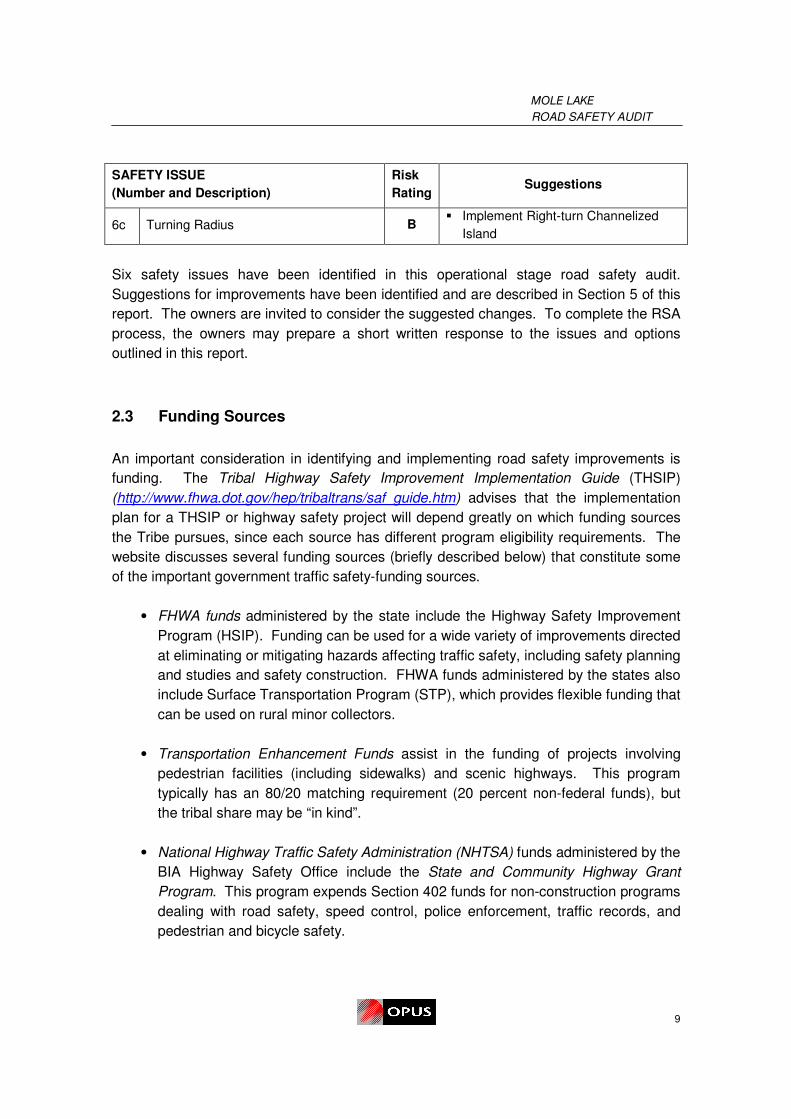
SAFETY ISSUE
(Number and Description)
Risk
Rating Suggestions
6c Turning Radius B � Implement Right-turn Channelized
Island
Six safety issues have been identified in this operational stage road safety audit.
Suggestions for improvements have been identified and are described in Section 5 of this
report. The owners are invited to consider the suggested changes. To complete the RSA
process, the owners may prepare a short written response to the issues and options
outlined in this report.
2.3 Funding Sources
An important consideration in identifying and implementing road safety improvements is
funding. The Tribal Highway Safety Improvement Implementation Guide (THSIP)
(http://www.fhwa.dot.gov/hep/tribaltrans/saf_guide.htm) advises that the implementation
plan for a THSIP or highway safety project will depend greatly on which funding sources
the Tribe pursues, since each source has different program eligibility requirements. The
website discusses several funding sources (briefly described below) that constitute some
of the important government traffic safety-funding sources.
• FHWA funds administered by the state include the Highway Safety Improvement
Program (HSIP). Funding can be used for a wide variety of improvements directed
at eliminating or mitigating hazards affecting traffic safety, including safety planning
and studies and safety construction. FHWA funds administered by the states also
include Surface Transportation Program (STP), which provides flexible funding that
can be used on rural minor collectors.
• Transportation Enhancement Funds assist in the funding of projects involving
pedestrian facilities (including sidewalks) and scenic highways. This program
typically has an 80/20 matching requirement (20 percent non-federal funds), but
the tribal share may be “in kind”.
• National Highway Traffic Safety Administration (NHTSA) funds administered by the
BIA Highway Safety Office include the State and Community Highway Grant
Program. This program expends Section 402 funds for non-construction programs
dealing with road safety, speed control, police enforcement, traffic records, and
pedestrian and bicycle safety.

MOLE LAKE
ROAD SAFETY AUDIT
10
• The IRR Program jointly administered by BIADOT and the Federal Lands Highway
Office and funded by FHWA, includes funds for projects to improve highway
safety. Twenty-five percent of the IRR Program funds are now usable for
maintenance. Examples of activities that are eligible for funding include sidewalks,
installation/replacement of safety-related signs when designated as part of a
highway safety project, guardrail, and pavement markings.
• The Indian Health Service Injury Prevention Program provides funding for basic
and advanced injury prevention projects. Funding can be used to build tribal
capacity for preventing any type of injury problem facing a tribal government.
• The Public Lands Highways Discretionary Program provides funding for
improvements to roads that are open to public travel and serve federal property.
This program is entirely discretionary in nature and there is no minimum level of
funding for projects. Public Lands Discretionary funding requires no local match,
but state and local financial support of a project is one of the factors considered
when the FHWA decides which projects it will fund.
MOLE LAKE
ROAD SAFETY AUDIT
11
3.0 ROAD SAFETY AUDIT TEAM AND MATERIALS
Location: Mole Lake, Wisconsin
RSA Team Members: Jeffrey S. Bagdade, P.E. Opus International Consultants
Nicole Thompson, EIT Opus International Consultants
Project Owner: Wisconsin Department of Transportation
Sokaogon Chippewa Community
Review Date: June 9-11, 2008
Review Stage: Operational stage RSA of existing roads
Start Up Meeting: June 9, 2008
Preliminary Findings
Meeting: June 11, 2008
Attended by: Opus International Consultants
Wisconsin Department of Transportation
Sokaogan Chippewa Band of Mole Lake
Documents Available for the RSA:
• WisDOT Town Plat Record
• Forest County AADT traffic volumes
• Collision data for 2003 through 2008
• STH 55 Plan and Profile sheets
• STH 55 Typical Section sheets
• STH 55 Cross-section sheets
• STH 55 Right-of-way Plat sheets
• Aerial photographs
• Proposed designs for Sand Lake Road
All documents were provided by WisDOT prior to or at the start-up meeting.

MOLE LAKE
ROAD SAFETY AUDIT
12
THIS PAGE WAS INTENTIONALLY LEFT BLANK.

MOLE LAKE
ROAD SAFETY AUDIT
13
4.0 SITE VISIT NOTES
Project Name: Mole Lake Road Safety Audit
Site Visit Date: Monday June 9 – Wednesday June 11, 2008 (dry and clear conditions)
Network Connectivity: STH 55 follows a north/south alignment through Mole Lake, and
provides connections to the cities of Crandon, Argonne, and Nelma towards the north and
Pickerel, Keshena, Shawano towards the south. CTH M ends at STH 55 and provides
east/west connections to CTH Z and north/south connections to CTH B. Sand Lake Road
provides access to the Tribal offices, and is a connection between STH 55 and CTH W.
Land Uses: The land use along STH 55 is a mix between rural, residential and
commercial. The largest development along the study corridor is the Mole Lake Casino,
Hotel and Conference Center.
Road User Characteristics: Moderate traffic volumes, consistent with the reported
AADT of 2,300 vehicles, were observed.
A variety of travel modes were observed, listed below:
Passenger cars, reflecting use by:
• Residents of Sokaogon Chippewa Reservation for
travel within Mole Lake, as well as travel to
neighboring communities
• Visitors to Mole Lake and surrounding areas,
including the casino, lakes, cottages, and future
ATV park
• Through traffic on STH 55, including up-north
traffic
Trucks traveling through Mole Lake consisted of
primarily logging trucks. Logging trucks are extremely
large and heavy, contributing to long stopping distances
and reaction times. This may be a potential hazard for
non-motorized road users crossing STH 55 where sight
distance is limited.

MOLE LAKE
ROAD SAFETY AUDIT
14
Recreational Vehicles (RVs) have similar attributes to
trucks, but drivers are less experienced.
Buses including tour buses and school buses. Tour
buses are utilized to accommodate visitors at the
Casino. School buses provide four stops for students on
STH 55.
All Terrain Vehicles (ATVs)/ Dirt Bikes, reflecting use by:
• Traveling within Mole Lake
• Recreational use
• ATVs are prohibited on state and county highways
but may be used on township roads only by
ordinance and with DNR restrictions
Snowmobiles are present during the winter and have
similar attributes as ATVs although are allowed within
state right-of-way.
Motorcycles have similar attributes as passenger cars
and may also be used as recreational vehicles.
Bicycles are primarily used for recreation among
children.
Pedestrians were observed walking on sidewalks, trails
and within the roadway along STH 55.
Road and Roadside Physical Characteristics:
� STH 55 is a two-lane rural road and curb and
gutter is present north of Mole Lake Road.
� An incomplete network of sidewalks and trails are
provided within Mole Lake.
� Intersections with local roads are STOP
controlled on the minor approach, and access to
adjacent private properties is direct and
uncontrolled.
� Posted speed limits are 35 mph between CTH M and Indian Settlement Road and
55 mph north outside of town.
MOLE LAKE
ROAD SAFETY AUDIT
15
The RSA also included a review of the planned upgrades to Sand Lake Road. Sand Lake
Road provides access to the Tribal offices and a proposed ATV park.
Night-time Conditions: Overhead lighting is provided along STH 55 in Mole Lake. Fair
to poor sign reflectivity provided little or no guidance during night time hours.

MOLE LAKE
ROAD SAFETY AUDIT
16
THIS PAGE WAS INTENTIONALLY LEFT BLANK

MOLE LAKE
ROAD SAFETY AUDIT
17
5.0 RSA ISSUES AND SUGGESTIONS
5.1 Safety Issue 1: All Terrain Vehicles and Dirt Bikes
Safety Issue 1(a): Interactions of Modes
Safety Issue 1(a) Description:
All terrain vehicles (ATVs) and dirt bikes have been
a growing mode of travel and recreation within
Mole Lake. It is an affordable method to travel
short distances. ATVs do not have separate
designated facilities to travel on; therefore, ATVs
are forced to share the roadway with vehicles or
interacting with non-motorized road users on the
sidewalks and trails.
An ATV campground is proposed off of Sand Lake Road on the east of STH 55, however
the ATV trails which are proposed are planned for the area west of STH 55. This will
increase the volume of ATV traffic crossing STH 55.
ATVs are allowed to travel within the public right-of-way on township roads, but not on
county roads and state trunk highways. During the RSA site visits, ATVs were observed
traveling illegally on STH 55 (above).
Currently ATVs and dirt bikes utilize sidewalks and trails, which interact with pedestrians
and recreational bike users. The sidewalks and trails are not wide enough to
accommodate the different modes side-by-side. ATVs and dirt bikes are motorized
vehicles which travel at a higher speed than pedestrians and bicyclists. This variance in
speed between the modes increases the risk of a collision, resulting in severe injuries.
The use of ATVs on trails can also lead to erosion, creating a hazardous walking facility
for pedestrians and increasing the potential for damage to the shoulders and ditches.

MOLE LAKE
ROAD SAFETY AUDIT
18
Expected Crash Types: ATV crashes
Expected Frequency: Infrequent
Expected Severity: High
Risk Rating: C (moderate risk level)
Safety Issue 1(b): Large Rocks
Safety Issue 1(b) Description:
Large rocks have been distributed to residents in
Mole Lake as a method to discourage ATVs from
traveling on the front lawns of private homes.
These large rocks may be considered to be
potential fixed objects. The encroachment of the
large rocks within the right-of-way and in some
areas within the clear zone presents a hazard to
vehicles that may have left the roadway, increasing
the likelihood of severe fixed object collisions
especially near driveways where there is a gap in
the curb.
Expected Crash Types: Fixed object crashes
Expected Frequency: Infrequent
Expected Severity: High
Risk Rating: C (moderate risk level)

MOLE LAKE
ROAD SAFETY AUDIT
19
Suggestions:
Multi-Modal Transportation Plan
The tribe may consider developing a multi-modal transportation plan to identify specific
facilities for pedestrians, bicycles, ATVs and dirt bikes. The ATV facilities should also take
into consideration accommodating snowmobiles in the winter. Separate facilities for these
different modes would reduce interactions between the different road user types and
speed variations. This would lessen the likelihood of a severe injury crash occurring.
Also, adequate facilities for ATVs with proper width and design would reduce the potential
for erosion and increase service life of the transportation facilities.
Local ATV Ordinance
A local ordinance to separate ATVs and dirt bikes from non-motorized road users
(pedestrians and bicycles) may be considered to enforce the proper use of the
transportation facilities. This ordinance could restrict the use of ATVs and dirt bikes from
sidewalks and other non-motorized trails.
Provide Alternative Barriers to Block ATVs
The tribe should consider promoting alternative barriers be used to prevent ATVs from
riding on resident’s lawns and sidewalks, other than large rocks. Break-away bollards
may be strategically placed along lawns and sidewalks to prevent ATVS from traveling,
however allowing pedestrians, strollers, and wheelchairs access. The break-away
bollards will decrease the potential injury severity from a fixed object crash. An example
photo is shown in SECTION 5.2.
Public Information and Education (PI&E) Campaigns
A Public information and education (PI&E) campaign should accompany selective
enforcement projects. PI&E campaigns maximize the impact of a safety message by
raising the perceived risk in motorist’s minds of being cited. The typical message for such
a campaign revolves around the premise that high speeds and interaction of different
modes may result in fatal and serious injury crashes. Included in this is the need to
establish a suitable theme or message. Perhaps the campaign might include testimonials
from residents who live on or near STH 55 about their concerns for safe travel along this
roadway. PI&E campaigns should be sure to target the appropriate audience, in this case
the ATV users. Keeping ATV users involved will maximize the effectiveness of the
campaign.

MOLE LAKE
ROAD SAFETY AUDIT
20
5.2 Safety Issue 2: Pedestrians
Safety Issue 2: Pedestrians walking along STH 55 have no continuous dedicated
pedestrian facilities.
Safety Issue 2 Description:
STH 55 runs north/south through the Mole Lake,
providing the major north/south links in the area.
Mole Lake residents were frequently observed
walking along the highway and crossing STH 55.
In several cases where sidewalks existed,
pedestrians prefer to walk on the road. This may
be due to the lack of a continuous network of
sidewalks and maintenance. Pedestrians at
highest risk include:
• Unaccompanied children
• Elderly pedestrians
• Wheelchair users
• Pedestrians pushing strollers
The risk of collision is increased by:
• Limited lighting conditions
• An absence of marked and signed pedestrian crossing facilities where drivers might
not be able to anticipate pedestrians
• Areas without shoulders, where pedestrians must walk on the roadway
Expected Crash Types: Pedestrian crashes
Expected Frequency: Infrequent
Expected Severity: Extreme
Risk Rating: D (significant risk level)

MOLE LAKE
ROAD SAFETY AUDIT
21
Suggestions:
Multi-Modal Transportation Plan
See Section 5.1.
Bollards and Gates
The tribe may also consider utilizing a system which
may include bollards and/or gates at key locations
along the sidewalks and trails accommodating
pedestrians and bicyclists. An example of a system of
bollards and gates is shown on the right. The spacing
between the bollards must be wide enough to
accommodate bicyclists, strollers and wheelchairs but
narrow enough to prevent ATVs from accessing the
sidewalk or trail. This system would ensure vehicles
and ATVs remain off the sidewalks and non-motorized
trails.
Establish and Maintain a Continuous Sidewalk for Pedestrians
To discourage pedestrians from walking along the highway shoulder, an alternative
network of pedestrian routes should be considered. Using the existing (non-continuous)
sidewalks already in place along STH 55 as the basis; this network of sidewalks should be
continuous and well-maintained so it is usable in all seasons.
As the pedestrian network is expanded with improved continuity, measures to improve
accessibility for disabled pedestrians need to be considered. Wheelchair accessibility
assists not only wheelchair users, but also other pedestrians with limited mobility, such as
persons using canes, walkers, and scooters. Compliance with the Americans with
Disabilities Act (ADA)1 is required for all new or altered non-motorized facilities including
sidewalks. This includes specific curb ramp design guidelines and detectible warnings for
blind pedestrians.
1 Draft Public Rights-of-Way Accessibility Guidelines (PROWAG), US Access Board (2002).

MOLE LAKE
ROAD SAFETY AUDIT
22
Designated Pedestrian Crossings
Guidelines in the Safety Effects of Marked vs. Unmarked Crosswalks at Uncontrolled
Locations2 suggest that marked crosswalks at uncontrolled locations could be considered
on two-lane roads where speed limit is 35 mph and AADT is less than 9,000 vehicles.
Crosswalks should be installed carefully and selectively, with particular regard to selecting
appropriate locations where sight distance requirements are met, and locating crosswalks
along convenient routes that pedestrians are likely to use.
Potential locations for marked crosswalk are listed below:
• Adjacent to the Casino’s hotel, near the historical marker and proposed museum
• Adjacent to the BP gas station
• At Sand Lake Road
• Adjacent to Indian Settlement Road
Marked crosswalks should include signing, crosswalks and ADA accessible sidewalks.
Lighting to illuminate the proposed crosswalks would enhance safety by providing drivers
on STH 55 with an indication that they are approaching a crosswalk. Lighting would also
enhance visibility of approaching vehicles for pedestrians waiting at the crosswalk.
5.3 Safety Issue 3: Speeds on STH 55
Safety Issue 3: Speeds above the posted speed limit increase the risk and potential
severity of crashes.
Safety Issue 3 Description:
The speed limit increases from 35 mph to 55
mph north of Indian Settlement Road and south
of CTH M. During the kick-off meeting it was
reported that drivers were frequently observed
traveling speeds of up to 55 mph through Mole
Lake. During site visits, vehicles were observed
traveling at higher speeds than the posted speed
limit (35 mph) through Mole Lake.
2 Zegeer, C.V., J.R. Stewart, H.H. Huang, P.A. Lagerway, J. Feaganes, and B.J. Campbell, FHWA
Safety Effects of Marked vs. Unmarked Crosswalks at Uncontrolled Locations, (Federal Highway
Administration, 2002).

MOLE LAKE
ROAD SAFETY AUDIT
23
Between Sand Lake Road and Sokaogon Drive,
the cross-section consists of 18 ft lanes including
30 in. Type D curb and gutter (right). North of
Sand Lake Road and south of Sokaogon Drive,
the cross-section consists of 15 ft lanes and 3 ft
shoulders. The 18-foot wide lanes on STH 55
between Sand Lake Road and Sokaogon Drive
are likely to contribute to speeding. The rural
environment may also contribute to speeding. High operating speeds combined with the
following factors increase the risk and the potential severity of collisions:
Pedestrians: A high volume of pedestrians were observed walking along and crossing
STH 55. High Speeds:
• Limit the time available for drivers to see and react to pedestrians in the roadway,
particularly at night;
• Increase the risk that a vehicle will lose control and enter the roadside area where
pedestrians are present; and,
• Increase the potential severity of a collision. Studies indicate that speed affects
the severity of pedestrian collisions3.
Access points: High speeds increase the risk of collisions when speeding drivers conflict
with slower vehicles turning into or out of an access point along STH 55.
School bus operations: School buses stop along STH 55 to pick-up and drop-off students.
High operating speeds increase the risk of collision with a school bus or younger
pedestrians.
Expected Crash Types: All crash types
Expected Frequency: Occasional
Expected Severity: Moderate
Risk Rating: C (moderate risk level)
3 Transportation Research Board, NCHRP Report 500 Volume 10: A Guide for Reducing Collisions
Involving Pedestrians , (National Cooperative Highway Research Program , 2004).

MOLE LAKE
ROAD SAFETY AUDIT
24
Suggestions:
Speed enforcement
Enforcement can be an effective measure to reduce speeding and other forms of
aggressive driving. An enforcement plan should be considered for development in
coordination between the tribe, Forest County Sheriffs Department and WisDOT. This
plan should assign patrols to specific stretches of STH 55 during specific time periods
correlating to both excessive speeding and associated crashes. In many cases, due to
lack of resources or knowledge, agencies will simply concentrate their patrols on wherever
the highest speeding is taking place. While this option is fallible in not connecting speed
related crashes to speed enforcement, it will often still serve an objective in showing the
public that speeding is not tolerated.
Narrow lanes with edgelines
Consider narrowing the lane width on STH 55 from 18 feet to 12 feet within the section
with the urban cross section. The new cross-section should be striped with 6 foot
shoulders. Narrowing the roadway should help to reduce the speeds.
Bicycle lanes may be considered within the proposed 6 foot shoulder. The Facilities
Development Manual (FDM)4 criteria for the installation of bicycle lanes include:
1. The highway or street is on an officially designated bike plan; or
2. The two-way bicycle traffic volume is or is expected to be 25 AADT or more
during the peak three months of the bicycling season where the current annual
traffic volume on the highway or street exceeds 1000 AADT.
According to the FDM, the minimum width of a
bicycle lane should be 4 feet measured between a
gutter/pavement longitudinal joint and the motor
vehicle traffic lane where curb and gutter. There is
4 feet available between the 12 foot lanes and the
curb and gutter which is adequate for a bike lane.
4 WisDOT, Facilities Development Manual, Procedure 11-45-10 (State of Wisconsin Department of
Transportation, 2005).

MOLE LAKE
ROAD SAFETY AUDIT
25
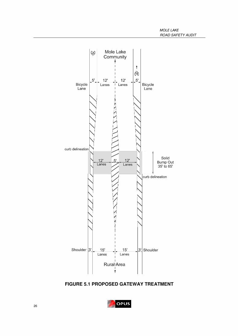
Gateway Treatment
A change in the road environment justifies a reduced speed limit. Drivers tend to travel
based on the design speed of the roadway and not the posted speed limit. A gateway
treatment may be implemented to inform drivers that they are transitioning from a rural
environment into a more urban environment. A gateway treatment consists of measures
that promote drivers’ awareness that they are entering a more urban area where slower
speeds are appropriate. Gateway treatments support, but do not replace, signing for a
reduced speed limit.
Research indicated drivers travel at a reduced speed where the height of vertical features
is greater than the width of the street5. Gateway treatments, which have been
summarized from the New Zealand Land Transport Safety Authority, should consist of
measures such as:
• Horizontal elements: Raised bump-outs to reinforce that the road is narrowing.
Raised pavement markers, reflective paint and/or object markers should be used to
delineate the raised bump-outs. The center median can either be raised or painted.
• Vertical elements: Oversized speed limit signs, roadside displays identifying entry
to the Mole Lake community, trees and shrubs including decorative landscaping,
artistic displays, or architectural displays should be placed adjacent to the bump
outs. Trees or shrubs should not limit sight distance between oncoming vehicles
and nearby access points.
• Other elements: Street lighting is desirable where raised bump outs are
implemented. Daytime conspicuity can be improved by including bright flowers or
shrubs in the landscaping, or colored or textured pavement within the gateway.
Night-time conspicuity can be improved by using highly reflective pavement
markings and lighting.
FIGURE 5.1 illustrates the gateway treatment concept.
5 Land Transport Safety Authority, Guidelines for Urban-Rural Speed Thresholds RTS 15
(Wellington, 2002).
MOLE LAKE
ROAD SAFETY AUDIT
26
FIGURE 5.1 PROPOSED GATEWAY TREATMENT

MOLE LAKE
ROAD SAFETY AUDIT
27
Gateway treatments must be visible for approaching drivers to provide adequate stopping
distance and must not limit sight distance from nearby access points. If sight distance
permits, place the gateway treatment at a location where the urban land use is evident to
drivers. Placing the speed reduction too far in advance of the community may reduce
compliance (speed reduction is not justified to motorists), or motorists may slowly increase
their speed by the time they reach the community.
Permanent Speed Feedback Signs
A permanent speed feedback sign informs drivers of the speed at which they are
traveling, and helps mitigate high speeds. The results of a research study6 indicated that
the permanent speed feedback sign is more effective if a perceived level of enforcement
exists, on a two-lane highway, where sight distance may be obstructed. Therefore, a
speed feedback sign on STH 55 may effectively reduce speeds due to a vehicle slowing
down which may influence vehicles following to slow down. The speed feedback sign
may be more effective due to the sight distance restrictions caused by variations in
horizontal alignment of the roadway. The use of flashers may be considered to make
these signs more conspicuous. Speed display signs may be connected to a computer
that records speeds along with the time of day and day of week, to help police identify
peak violation times so they can more effectively target their enforcement efforts.
Speed feedback signs may be located near the area where the speed limit decreases
from 55 mph to 35 mph. Signs may also be considered to reinforce the 35 mph speed
zone midway between Sokaogon Drive and Sand Lake Road.
5.4 Safety Issue 4: Signs
Safety Issue 4(a): Sign Reflectivity
Safety Issue 4(a) Description:
Signs provide warning and guidance to drivers concerning road alignment and conditions.
During site visits, the RSA team observed signs that were worn or beyond its useful life,
limiting retroreflectivity and conspicuity especially during nighttime hours. At these
locations, driver guidance was limited by the following items:
• Inconspicuous street name signs may result in sudden braking and erratic
maneuvers for unfamiliar drivers (bottom left),
6 Rose, E.R., and G.L. Ullman, FHWA Evaluation of Dynamic Speed Display Signs (DSDS), (U.S.
Department of Transportation Federal Highway Administration, 2003).

MOLE LAKE
ROAD SAFETY AUDIT
28
• Cracked regulatory signs may not be visible at night therefore reducing driver
compliance (bottom center),
• Faded or damaged warning signs may not provide adequate delineation and
guidance (bottom right).
Expected Crash Types: All crash types
Expected Frequency: Occasional
Expected Severity: Moderate
Risk Rating: C (moderate risk level)
Safety Issue 4(b): Sign Standards
Safety Issue 4(b) Description:
“Slow Children at Play” signs (below left) are posted in
areas where pedestrians, particularly children, may be
crossing the road. These signs are not consistent with
current signs posted throughout the state and nation. This
sign may also pose as a hazard for children by
encouraging children to play in the road. It has been
found in other areas that this sign message creates a false
sense of security for children as they assume drivers know

MOLE LAKE
ROAD SAFETY AUDIT
29
that they are in the road may not find it necessary to clear oncoming traffic.
Yellow advisory speed plaques (below right)
were posted throughout Mole Lake in lieu of
standard speed limit signs. The MUTCD7 states
that supplemental plaques shall not be mounted
alone or displayed alone, and shall be installed
on the same post as a warning sign. Signs not in
compliance with MUTCD standards may confuse
or misinform drivers.
Expected Crash Types: All crash types
Expected Frequency: Occasional
Expected Severity: Moderate
Risk Rating: C (moderate risk level)
Suggestions:
Minimum Retroreflective Standards
To improve night-time conspicuousness and visibility, and reduce long-term maintenance
requirements, the use of higher retroreflective sheeting is now required. In December
2007 the FHWA began requiring that all transportation agencies implement a system of
maintaining minimum retroreflectivity for signs. Engineering-grade sheeting (ASTM Type
1) needs to be replaced with more reflective sheeting which meets these new standards,
such as high intensity (ASTM Type 3 or 4) or prismatic (ASTM Type 9 or Type 11)
sheeting.
7 MUTCD Manual on Uniform Traffic Control Devices for Streets and Highways 2003 Edition, (U.S.
Department of Transportation Federal Highway Administration, 2007).
MOLE LAKE
ROAD SAFETY AUDIT
30
The minimum retroreflective standard stated in the MUTCD8 is that regulatory, warning,
and guide signs shall be retroreflective or illuminated to show the same shape and similar
color by both day and night.
Upgrade signs
A comprehensive signing review should be undertaken throughout Mole Lake as a result
of the new standards. It is suggested that a process which identifies and documents sign
maintenance issues involving damaged signs, signs with poor retroreflectivity, or obsolete
signs that should be removed be considered.
The following timeline is stated in the MUTCD from the effective date December 2007 for
the upgrade of signs:
• Four years for implementation and continued use of an assessment or
management method that is designed to maintain traffic sign retroreflectivity
at or above the established minimum levels;
• Seven years for replacement of regulatory, warning, and ground-mounted
guide (except street name) signs that are identified using the assessment or
management method as failing to meet the established minimum levels and
repeated every seven years; and
• Ten years for replacement of street name signs that are identified using the
assessment or management method as failing to meet the established
minimum levels and repeated every ten years.
MUTCD Standards
During the process of upgrading signs, MUTCD sign standards should be implemented.
Below are a few examples of standard MUTCD signs that are suggested for
implementation in Mole Lake.
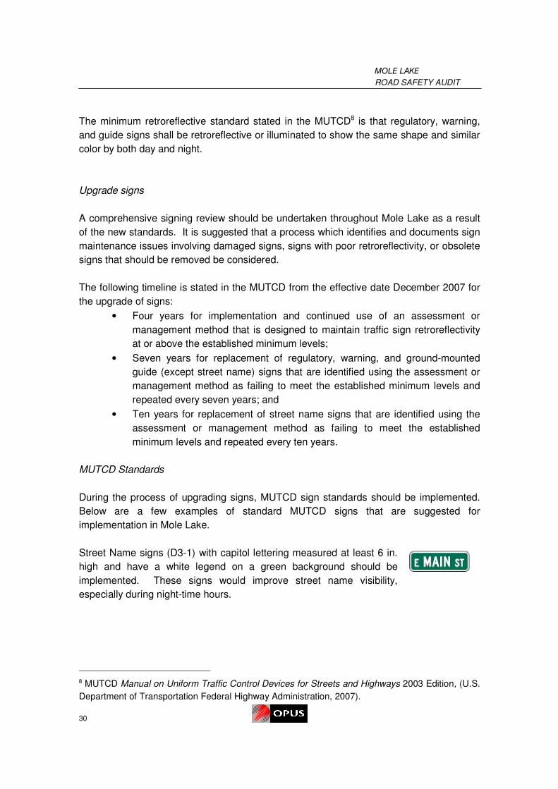
Street Name signs (D3-1) with capitol lettering measured at least 6 in.
high and have a white legend on a green background should be
implemented. These signs would improve street name visibility,
especially during night-time hours.
8 MUTCD Manual on Uniform Traffic Control Devices for Streets and Highways 2003 Edition, (U.S.
Department of Transportation Federal Highway Administration, 2007).

MOLE LAKE
ROAD SAFETY AUDIT
31
Areas where high volumes of pedestrians are crossing the road, a
pedestrian sign (R11-2) may be posted. Drivers would be more aware of
pedestrians due to the proper signing and children would feel less
encouraged to play in the road.
The advisory speed plaques should be replaced with standard regulatory
speed limit signs (R2-1) to remain consistent with standards. The proper
speed limit signs would effectively inform drivers of the speed limit.
5.5 Safety Issue 5: Bridge over Swamp Creek
Safety Issue 5(a): Trail
Safety Issue 5(a) Description:
An unofficial trail adjacent to the bridge over
Swamp Creek is extremely close to the box
culvert. The box culvert is unshielded and is
seen as a hazard for ATV’s and pedestrians
utilizing the trail. A risk is associated with
pedestrians, bicyclists, ATVs or dirt bikes falling
into the shallow creek, resulting in a severe
injury.
Expected Crash Types: ATV and pedestrian crashes
Expected Frequency: Rare
Expected Severity: Extreme
Risk Rating: C (moderate risk level)

MOLE LAKE
ROAD SAFETY AUDIT
32
Safety Issue 5(b): Interaction of Modes
Safety Issue 5(b) Description:
ATVs, pedestrians and bicyclists utilize the trail
adjacent to the Bridge over Swamp Creek. The
trail is not wide enough to comfortably
accommodate the different modes. During the
site visits, frequent interactions between ATVs
and pedestrians were observed. This increases
the risk of a collision between an ATV and a
pedestrian or someone falling into the shallow
creek. Also, ATVs utilizing the trail contributed to
erosion, creating a hazardous walking facility for
pedestrians and damage to the bridge structure.
Expected Crash Types: ATV and pedestrian crashes
Expected Frequency: Infrequent
Expected Severity: High
Risk Rating: C (moderate risk level)
Safety Issue 5(c): Crossing STH 55
Safety Issue 5(c) Description:
Intersection conspicuity at Sand Lake Road is
limited by the presence of a horizontal curve. A
high volume of pedestrians and ATVs were
observed crossing at the south end of the bridge
over the Swamp Creek to get to Sand Lake Road
and the sidewalk on the south side of the
intersection. Visibility of crossing pedestrians is
further limited by the guardrail and the slope
approach to the unmarked crossing on the west

MOLE LAKE
ROAD SAFETY AUDIT
33
side of STH 55. No pedestrian warning signs are provided on the approaches. Drivers
may not realize that a pedestrian, bicycle or ATV is within the roadway due to these sight
distance restrictions, resulting in inadequate reaction time.
A bicycle fatality was reported when a bicyclist was struck by a southbound vehicle while
crossing STH 55 at Sand Lake Road, approximately six years ago. The RSA team
understands that this crash may have occurred as a result of limited sight distance due to
the sloped trail which is obscured by the guardrail.
Expected Crash Types: ATV and pedestrian crashes
Expected Frequency: Infrequent
Expected Severity: Extreme
Risk Rating: D (significant risk level)
Safety Issue 5(d): Intersection Visibility
Safety Issue 5(d) Description:
Drivers approaching Sand Lake Road on STH 55
have a limited view of the intersection due to the
horizontal curve. Sand Lake Road is expected to
attract significant numbers of unfamiliar drivers in
the future looking to access the proposed ATV
campground which will result in higher traffic
volumes. Unfamiliar drivers may not expect the
Sand Lake Road in advance of the intersection
due to the lack of advance signing, resulting in
sudden braking or unsafe u-turns.
Restricted sight visibility may also be an issue for drivers who may not expect vehicles
ahead to slow down to turn onto Sand Lake Road, or vehicles to turn off of Sand Lake
Road in front of them.

MOLE LAKE
ROAD SAFETY AUDIT
34
Expected Crash Types: Rear-end, Sideswipe, and Angle collisions
Expected Frequency: Occasional
Expected Severity: High
Risk Rating: D (significant risk level)
Suggestions:
Close Trail
The existing trail should be considered for closure due to the hazards associated with the
adjacent box culvert and erosion of the bridge. Separate facilities should be considered to
accommodate pedestrians and ATVs. If trail remains open, a barrier should be
implemented to protect anyone from falling into the shallow creek.
Provide Pedestrian Facilities on Bridge
Pedestrian facilities should be considered on the Swamp Creek Bridge, to accommodate
pedestrians wanting to cross Swamp Creek. This would provide pedestrians a facility
which will discourage them from walking in the road along this high speed horizontal
curve.
Separate ATV Crossing of the Swamp Creek
As a result of the growing volume of ATVs, dirt bike and snowmobile traffic in Mole Lake a
separate crossing facility over Swamp Creek should be considered. This facility should
take into consideration the use of snowmobiles in the winter. An adequate facility for
these motorized recreational vehicles will provide for separation of all of the transportation
modes crossing the Swamp Creek.

MOLE LAKE
ROAD SAFETY AUDIT
35
Lighting and Pedestrian Signing
Lighting during night-time hours should be implemented to improve
pedestrian and vehicle visibility in areas where substantial pedestrian and
vehicle volumes may conflict, such as the proposed crosswalk at Sand
Lake Road. Lighting would also enhance the conspicuousness of the
intersection, and may reduce all types of night-time collisions. A
pedestrian crossing sign (W11-2) including a supplemental arrow plaque
(W16-7p) and advanced pavement markings should also be considered to enhance the
visibility of the crosswalk. Pedestrian-activated flashers or rectangular strobes may be
considered to warn drivers when pedestrians are using the crosswalk. It is noted that
marked crosswalks alone are not recommended in areas where sight distance
requirements are not met.
Advance Intersection Signing
Provide a sign on STH 55 (similar to sign on right) to warn drivers of the
intersecting road, allowing drivers to navigate road cautiously. A
supplemental plaque with the street name of the cross street may be
implemented to inform drivers of the roadway, prior to the intersection,
reducing sudden braking near the intersection. The supplemental street
name sign would better inform unfamiliar drivers visiting the proposed
ATV campground.
5.6 Safety Issue 6: Sand Lake Reconstruction
Safety Issue 6(a): 10 ft lanes
Safety Issue 6(a) Description:
Sand Lake Road is a primary connection
between STH 55 and CTH W. It is also the main
access point for the tribal offices and the future
ATV campground. During site visits a high
volume of logging trucks and dump trucks were
observed utilizing the roadway. The existing
pavement condition is also deteriorating,
affecting driver control and load stability.

MOLE LAKE
ROAD SAFETY AUDIT
36
The proposed ATV campground will attract significant amounts of large vehicles such as
RVs. To accommodate these large vehicles and the future traffic growth, Sand Lake
Road is scheduled to be reconstructed. The proposed design of the roadway incorporates
10 ft lanes, however it has been indicated that the design has been changed to 12 ft
lanes. Ten foot lanes may not comfortably accommodate two large vehicles side-by-side.
Expected Crash Types: Sideswipe-opposite collisions
Expected Frequency: Occasional
Expected Severity: Low
Risk Rating: B (low crash risk)
Safety Issue 6(b): Intersection control
Safety Issue 6(b) Description:
The intersection of Sand Lake Road/Black Joe Road/Community Drive is also included
within the planned reconstruction. The intersection is proposed to accommodate traffic
continuing on Sand Lake Road as a free-flow movement. Community Drive and Black
Joe Road are STOP controlled. The westbound approach on Sand Lake Road is also
STOP controlled except for the right-turn movements continuing on Sand Lake Road. A
sign proposed underneath the STOP sign states, “Right Turn No Stop”.

MOLE LAKE
ROAD SAFETY AUDIT
37
The proposed intersection control is not intuitive. Drivers waiting at the STOP control may
not realize southbound Sand Lake Road is uncontrolled. Westbound right-turn
movements from Sand Lake Road may also be an issue. Drivers may perceive that the
right-turn vehicle is slowing down to Stop, where instead the vehicle is slowing down to
turn right onto northbound Sand Lake Road. The proposed intersection control may
increase the number of conflicts and the likelihood of a collision to occur.
Expected Crash Types: All crash types
Expected Frequency: Occasional
Expected Severity: Moderate
Risk Rating: C (moderate crash risk)
Safety Issue 6(c): Turning Radius
Safety Issue 6(c) Description:
During site visits, vehicles were observed backing up to avoid being struck by a truck
turning right onto Sand Lake Road. The proposed ATV campground will also increase the
volume of large turning vehicles onto Sand Lake Road. Therefore, the turning radius on
the southeast corner at Sand Lake Road may not be large enough to comfortably
accommodate trucks and RVs.
N

MOLE LAKE
ROAD SAFETY AUDIT
38
Expected Crash Types: Truck related crash types
Expected Frequency: Occasional
Expected Severity: Low
Risk Rating: B (low crash risk)
Suggestions:
12 foot lanes
Twelve foot lanes are recommended on Sand Lake Road to accommodate the future
traffic growth of large vehicles. The Geometric Design of Highway and Streets9 states
that 12 foot wide lanes provide desirable clearance between large vehicles on two-lane
two-way rural highways where large vehicles are expected. It is recommended that the
tribe confirm that the lane widths in the designs have been updated to 12 foot lanes.
Two-way Stop Control
A two-way stop control at Sand Lake Road intersecting with Black Joe Road and
Community Drive would reduce driver confusion and frustration. Drivers would be able to
perceive whether a vehicle will continue through the intersection or STOP at the control.
The two-way stop control would improve intersection operations and reduce the number of
conflicts.
Implement Right-turn Channelized Island
A right-turn channelized island may be implemented on the northbound approach to Sand
Lake Road. A right-turn channelized island would increase the radius on the southeast
corner and comfortably accommodate trucks and RVs turning right onto Sand Lake Road.
9 AASHTO, A Policy on Geometric Design of Highways and Streets, (American Association of State
Highway and Transportation Officials, 2004).

MOLE LAKE
ROAD SAFETY AUDIT
39
THIS PAGE WAS INTENTIONALLY LEFT BLANK


• Road Safety Engineering
• Transportation Planning
• Traffic Operations
• Transit and Sustainability
• Community and School Safety
• Asset Management