Embed Size (px)
Citation preview

Mono Basin Visioning Steering Committee 07.15.2010

Community visioning is both a process and an outcome
Visioning leads to a clearly defined “goals statement”
Sets a strategy for achieving the goals identified and prioritizes them
Consists of a series of meetings/outreach that focus on long-range issues
Identifies key stakeholders and community members to seek input on a long-range plan Focus is to find common ground among participants in
exploring and advocating strategies for the future

to set the stage for short-range planning activities;
to set new directions in policy; to review existing policy; when integration between issues
is required; when a wide variety of ideas
should be heard; and when a range of potential
solutions is needed.

Resolution to the Board of Supervisors Review of existing policies and goals defined by:
The Mono County General Plan Land Use and Regional Transportation Plan Policies for the Long Valley Area
The current Mono Basin policies is building upon and implementation of these established goals and priorities
Don Bauer [Bauer Environmental Consulting, inc] began work in 2003 to develop a ‘Vision’ for the Lee Vining area that would help facilitate implementation of the communities goals
Streetscape Corridor Enhancement Plan (Blueprint planning) Future Planning
Corridor Management Plan (National Scenic Byway Grant) Land Tenure (prototype)

Key stakeholders: Library, market, trailer park, County, private property owners, community members
RPAC meetings to facilitate outreach and keep community involved throughout process forward
What do we expect to be the final product, outcome? Implementation As a result of outreach; what has the community said
they want to see What are their goals Has there been surveys, informal discussions, any data
to back why this is a reflection of the communities desires?

ISSUES/OPPORTUNITIES/CONSTRAINTS FOR MONO BASIN
The extremely limited private land base throughout Mono Basin and especially in Lee Vining limits potential community expansion in the area. In Lee Vining, there is some potential for land exchanges or purchases either with the USFS or the LADWP.
Residents of Lee Vining would like to see some affordable housing developed in the area, either rental units or single-family units.
Residents of Mono City are concerned about the expansion of their community beyond the current limits of the subdivision. They are concerned about possible impacts to visual quality and to the deer herd in the area. The impacts from increased traffic levels are also a concern.
Both in Lee Vining and Mono City there are some concerns about the water supply systems. The Mono City system has enough to supply the lots in the existing subdivision but not to supply additional development beyond that level. The Lee Vining Public Utility District (PUD) is currently in the process of improving its supply in order to serve additional development and to meet new water quality standards established by the state.

GOAL: Provide for the orderly growth of Mono Basin communities in a manner that retains the small town character, coincides with infrastructure expansion, facilitates economic and community development, and protects the area's scenic, recreational, and natural resources.

Objective ADirect future development to occur in and adjacent to Lee Vining.
Policy 1: Obtain lands necessary for the orderly expansion of Lee Vining.
Action 1.1: Work with appropriate agencies to provide for developable lands adjacent to Lee Vining.
Action 1.2: Designate lands adjacent to Lee Vining for community expansion in the Land Use Element.
Policy 2: Future development should coincide with infrastructure and service capability expansion.
Action 2.1: Support and assist the Lee Vining PUD in securing sufficient water for community growth.
Action 2.2: Require development projects to obtain "will-serve" letters from applicable service agencies.

Objective BEncourage infill development of Mono City prior to considering development on
adjacent lands.
Policy 1: Existing lots at Mono City should be developed before adjacent lands are considered for development.
Policy 2: If necessary, obtain lands for the orderly expansion of Mono City.
Action 2.1: Request the BLM to designate lands adjacent to Mono City for potential future land disposal, when and if demand for additional development warrants such disposal.
Policy 3: Future development should coincide with infrastructure and service capability expansion.

Objective CMaintain the scenic, recreational, and natural attributes of areas outside Lee Vining and Mono
City.
Policy 1: Ensure that future development outside existing communities is compatible with the scenic, recreational, and natural attributes of the area.
Action 1.1: Provide for low intensity uses (e.g., low density residential uses) outside of Lee Vining and Mono City. Higher intensity uses (e.g., limited commercial, industrial, and resource extraction) may be permitted if it can be demonstrated that the use cannot be accommodated in existing community areas, that the use is incompatible with existing community uses, or that the use directly relies on the availability of unique on-site resources. Higher intensity uses should not adversely impact the area's scenic, recreational, and natural resources.
Action 1.2: Require preparation of a Specific Plan and EIR for subdivisions of 30 parcels or more that are not within or adjacent to Lee Vining or Mono City.
Action 1.3: Require preparation of a Specific Plan or PUD for development projects proposed on federal exchange lands (parcel maps are exempt from this requirement).
Action 1.4: Periodically review the Conway Ranch Specific Plan and any other future specific plans in the Mono Basin.

Objective DGuide development to provide for community needs.
Policy 1: Encourage the development of affordable housing, including rental units.
Policy 2: Provide a site for limited industrial uses, including road yards, heavy equipment storage, and similar uses, within or adjacent to Lee Vining.
Action 2.1: Consider relocating visually offensive land uses, such as road yards, to the designated industrial site.
Policy 3: Focus commercial development within or adjacent to Lee Vining.
Policy 4: Provide a community center in Lee Vining.

Example of Poor Planning
What if we did nothing?
Tend to remain the same
Increased ‘Quality of Life’ as defined and implemented
through a Community Vision

Future 3 meetings will focus on one element of the Vision at a time:1. Identifying Trails (06.30.10)2. Traffic Calming Measures (T.B.D.)3. Creation of Community Core (T.B.D.)
Direction from RPAC to determine additional steps forward, i.e. Potential additional meetings: Combination of elements into one plan Workshops Field Trips Open House
Contact Person from RPAC to coordinate with County Staff/Consultant periodically for updates/direction


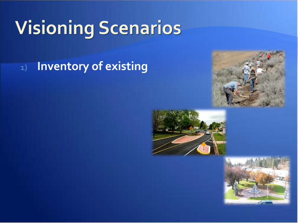
1) Inventory of existing

Safety Emergency Access “Police-ability” Identify existing trails Where are people
walking/biking as of now?
Prioritize which trails are easiest to formalize
Environment Constraints Topography Wetlands Private property Needed improvements
Trail Maintenance Needed access
easements Fiscal Impacts


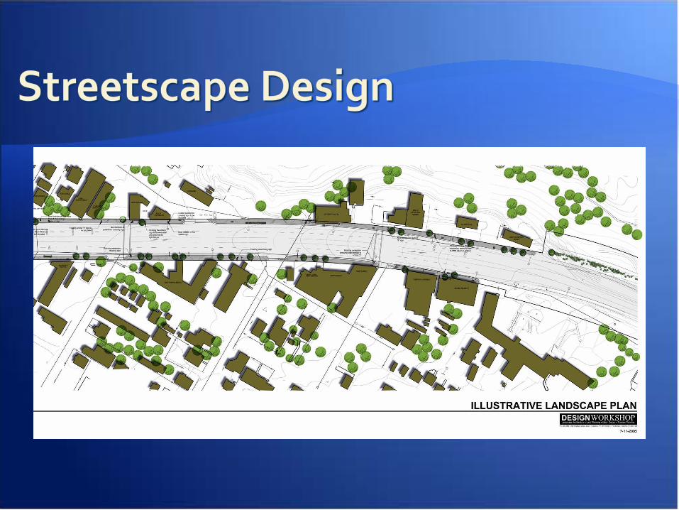
•Zoom in to areas that are more complex and requires detailed explanation of your trail proposal•If there are alternatives to this specific area, using the samescale and colors for the trails, offer it is the alternative and explain the differences

Explain Graphic:i.e. What is being shown here, why did you choose to zoom in to this area?, etc.

Safety Review Common
Techniques Narrow streets Streetscape Improvements Landscaping Round-a-bouts Medians Emergency Access
requirements
On-street Parking Existing Constraints Topography Private property Needed improvements
Right of Way improvements
Needed access easements Fiscal Impacts

Explain and point out different elements/options of the proposal

Have multiple slides of all figures related to traffic calming ideasExplain the options/alternatives clarifying between each the:•Differences•Benefits•Constraints of each

Safety Review Common
Techniques Narrow streets Streetscape Improvements Landscaping Round-a-bouts Medians Emergency Access
requirements
On-street Parking Existing Constraints Topography Private property Needed improvements
Right of Way improvements
Needed access easements Fiscal Impacts

Have multiple slides of all figures related to the community core ideas (J, Ja, Jb)Explain the options/alternatives clarifying between each the:•Differences•Benefits and;•Constraints of each