Embed Size (px)
Citation preview

Monterey Highway 1 Culvert Replacement
Between 2.5 miles north of the Monterey/San Luis Obispo county line and 0.6 mile south of Malpaso Creek Bridge
05-MON-1-2.5/67.3
Project ID # 0513000052
Initial Study with Proposed Negative Declaration
Prepared by the State of California Department of Transportation
December 2015
General Information About This Document
Please read this Initial Study. Copies of this document are available for review at the Caltrans district office at 50 Higuera Street, San Luis Obispo, California 93401. Additional copies are available at the Big Sur Branch of the Monterey County Library; Ripplewood Resort, 47047 Highway 1, Big Sur, California 93920; and Carmel Valley Branch of the Monterey County Library, 65 West Carmel Valley Road, Carmel Valley, California 93924.
The document can also be accessed electronically at the following website: www.dot.ca.gov/dist05/projects under “Monterey County”.
After comments are received from the public and reviewing agencies, Caltrans may 1) give environmental approval to the proposed project, 2) do additional environmental studies, or 3) abandon the project. If the project is given environmental approval and funding is appropriated, Caltrans could design and build all or part of the project.
For individuals with sensory disabilities, this document can be made available in Braille, in large print, on audiocassette, or on computer disk. To obtain a copy in one of these alternate formats, please call or write to Caltrans, Attn: Kirsten Helton, Senior Environmental Planner, 855 M Street, Suite 200, Fresno, CA 93721; (559) 445-6461 (Voice), or use the California Relay Service 1 (800) 735-2929 (TTY/Voice), or 711.


Monterey Highway 1 Culvert Replacement 1
Project Description and Background
Project Title Monterey Highway 1 Culvert Replacement
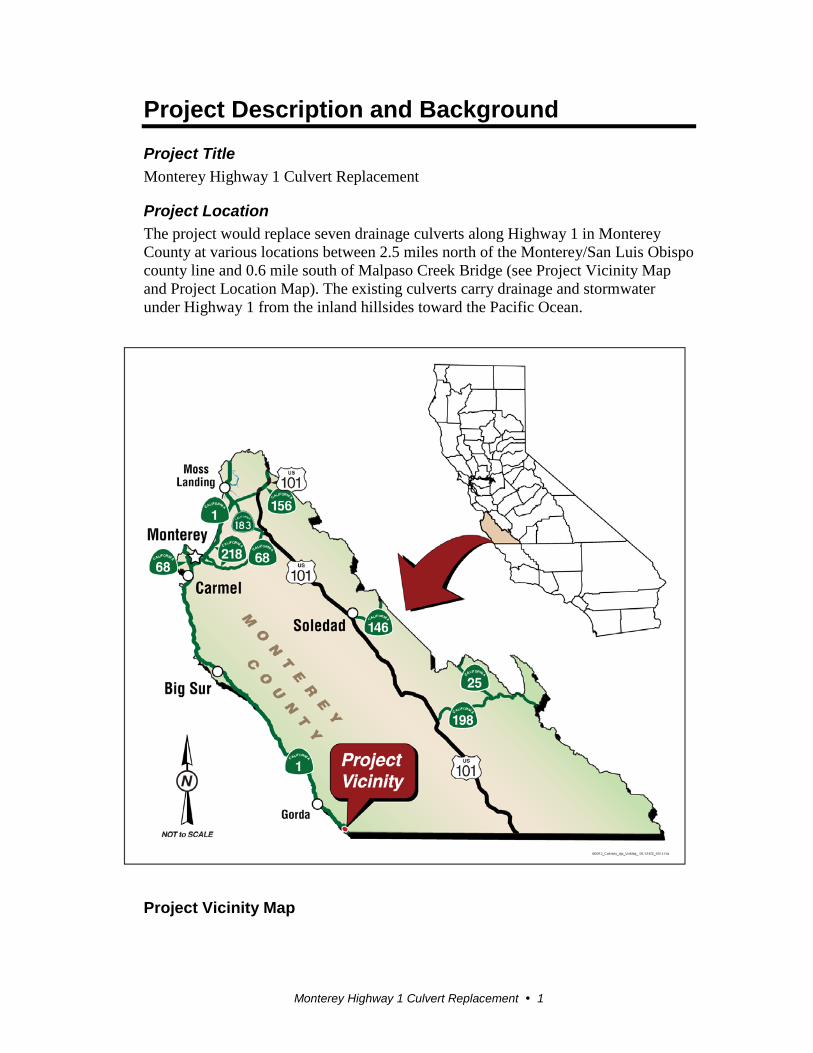
Project Location The project would replace seven drainage culverts along Highway 1 in Monterey County at various locations between 2.5 miles north of the Monterey/San Luis Obispo county line and 0.6 mile south of Malpaso Creek Bridge (see Project Vicinity Map and Project Location Map). The existing culverts carry drainage and stormwater under Highway 1 from the inland hillsides toward the Pacific Ocean.
Project Vicinity Map
Monterey Highway 1 Culvert Replacement 2
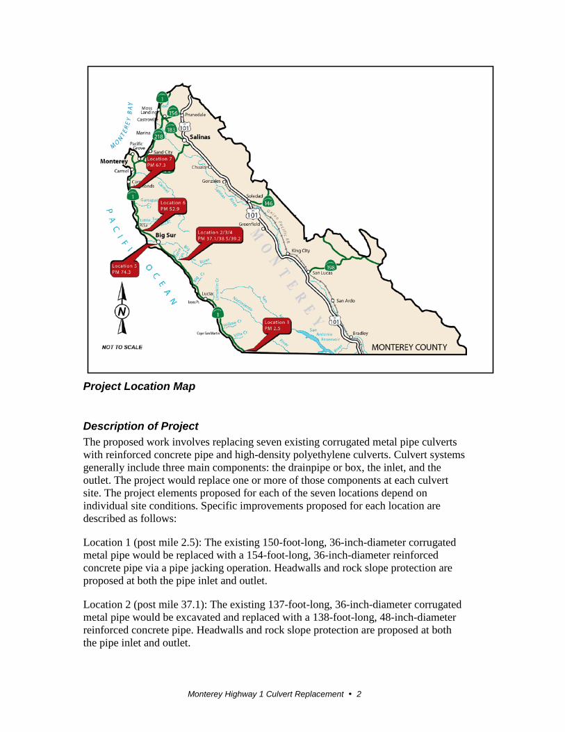
Project Location Map
Description of Project The proposed work involves replacing seven existing corrugated metal pipe culverts with reinforced concrete pipe and high-density polyethylene culverts. Culvert systems generally include three main components: the drainpipe or box, the inlet, and the outlet. The project would replace one or more of those components at each culvert site. The project elements proposed for each of the seven locations depend on individual site conditions. Specific improvements proposed for each location are described as follows:
Location 1 (post mile 2.5): The existing 150-foot-long, 36-inch-diameter corrugated metal pipe would be replaced with a 154-foot-long, 36-inch-diameter reinforced concrete pipe via a pipe jacking operation. Headwalls and rock slope protection are proposed at both the pipe inlet and outlet.
Location 2 (post mile 37.1): The existing 137-foot-long, 36-inch-diameter corrugated metal pipe would be excavated and replaced with a 138-foot-long, 48-inch-diameter reinforced concrete pipe. Headwalls and rock slope protection are proposed at both the pipe inlet and outlet.
Monterey Highway 1 Culvert Replacement 3
Location 3 (post mile 38.5): The existing 146-foot-long, 36-inch-diameter corrugated metal pipe would be excavated and replaced with a 146-foot-long, 48-inch-diameter high-density polyethylene culvert. A headwall and rock slope protection are proposed at the pipe inlet, and a 409-foot-long, 36-inch-diameter high-density polyethylene downdrain would extend from the pipe outlet down the cliff to drain into the ocean.
Location 4 (post mile 39.2): The existing 120-foot-long, 42-inch-diameter corrugated metal pipe would be excavated and replaced with 110-foot-long and 8-foot-long, 48-inch-diameter high-density polyethylene culverts. These culverts would be connected with a type G2 drop inlet surrounded by a 3-foot concrete apron to solve a roadside flooding issue that occurs during high flows. A headwall and rock slope protection are proposed at the pipe inlet, and an 804-foot-long, 36-inch-diameter high-density polyethylene downdrain would extend from the pipe outlet down the cliff to drain into the ocean. Also, about 140 feet of existing guardrail would be replaced at Location 4.
Location 5 (post mile 47.3): The existing 52-foot-long, 36-inch-diameter corrugated metal pipe would be excavated and replaced with a 52-foot-long, 60-inch-diameter reinforced concrete pipe. Headwalls and rock slope protection are proposed at both the pipe inlet and outlet. During construction, the water flow would be temporarily diverted away from the inlet to an area about 350 feet to the southeast via a flexible plastic pipe.
Location 6 (post mile 52.9): The existing 131-foot-long, 36-inch-diameter corrugated metal pipe would be replaced with a 178-foot-long, 48-inch-diameter reinforced concrete pipe via a pipe jacking operation. Headwalls and rock slope protection are proposed at both the pipe inlet and outlet. At the outlet side of the roadway, an existing 12-inch-diameter downdrain would be replaced by a 73-foot-long, 12-inch-diameter corrugated metal pipe downdrain.
Location 7 (post mile 67.3): The existing 144-foot-long, 36-inch-diameter corrugated metal pipe would be replaced with a 153-foot-long, 36-inch-diameter reinforced concrete pipe via a pipe jacking operation. A new 15-foot-long, 36-inch-diameter reinforced concrete pipe would be installed at the outlet end of the jacked pipe to more effectively drain water into the existing drainage basin. Headwalls and rock slope protection are proposed at both the pipe inlet and outlet. To perform the pipe jacking operations at Locations 1, 6, and 7, the contractor would grade a temporary 36-foot by 14-foot jacking pit at the inlet side of the roadway. Likewise, a temporary 16-foot by 8-foot receiving pit would be situated on the outlet side of the roadway. Two temporary roads would be built to provide access to these graded areas.
At Locations 2, 3, 4, and 5, any trenched areas on Highway 1 would be backfilled with slurry cement, and the roadway would be patched with hot mix asphalt.
Surrounding Land Uses and Setting Highway 1 along most of the project length is a two-lane highway with 12-foot lanes. Shoulder widths vary from 0 to 8 feet, with most 4 feet or less. Highway 1 in
Monterey Highway 1 Culvert Replacement 4
Monterey County serves local and interregional traffic, which includes mostly recreationists, local commuters, and limited commercial users. Highway 1 in Monterey County is designated as an Official State Scenic Highway, a National Scenic Byway, and an All-American Road.
The project passes through several landscape types along its length. The landform of the region is generally characterized by steep slopes and ravines forming a series of ridgelines and valleys as the mountains rise from the Pacific Ocean. The topography of the region is generally steeper in the southern section and allows more opportunity for long-range vistas toward the west.
The Pacific Ocean is visible throughout much of the route and can be seen from many of the project locations. Numerous seasonal streams exist throughout the area.
Highway 1 passes through a variety of plant communities and vegetative types within the project limits. In general, creeks and drainages hold stands of sycamore, redwood, cottonwood and willow trees. Oak and other native trees are found mostly at the upper elevations, along with coastal chaparral.
Along the highway through the project limits, the main developments are the roadway itself and related features, occasional roadside home sites, and tourist-oriented businesses. Overhead utilities and roadside signage are present along the route.
Other Public Agencies Whose Approval is Required In addition to California Environmental Quality Act requirements, the project would be subject to requirements of the National Environmental Policy Act because federal funding would be involved. Under the National Environmental Policy Act delegation authority designated in the Safe, Accountable, Flexible, Efficient, Transportation Equity Act: A Legacy for Users, Caltrans plans to make a determination that the project is Categorically Excluded under the National Environmental Policy Act.
The following permits would be required for this project.
Agency Permit/Approval Status
California Coastal Commission
Coastal Development Permit Coordination Started
Regional Water Quality Control Board
Section 401 Water Quality Certification
Coordination Started
U.S. Army Corps of Engineers
Section 404 Nationwide Permit Coordination Started
California Department of Fish and Wildlife
Section 1602 Streambed Alteration Agreement Coordination Started
U.S. Fish and Wildlife Service
Programmatic Biological Opinions Completed
Monterey Highway 1 Culvert Replacement 5
CEQA Environmental Checklist This checklist identifies physical, biological, social and economic factors that might be affected by the proposed project. In many cases, background studies performed in connection with the projects indicated no impacts. A NO IMPACT answer in the last column reflects this determination. Where a clarifying discussion is needed, the discussion either follows the applicable section in the checklist or is placed within the body of the environmental document itself. The words “significant” and “significance” used throughout the following checklist are related to CEQA—not NEPA—impacts. The questions in this form are intended to encourage the thoughtful assessment of impacts and do not represent thresholds of significance. Potentially
Significant Impact
Less Than Significant with Mitigation
Less Than Significant Impact
No Impact
I. AESTHETICS: Would the project:
a) Have a substantial adverse effect on a scenic vista? Explanation: A revegetation plan is a component of this culvert replacement project. Installation of the culvert, headwall and outfall structures would not adversely affect any designated scenic resource. (Visual Impact Assessment, May 2015)
b) Substantially damage scenic resources, including, but not limited to, trees, rock outcroppings, and historic buildings within a state scenic highway?
Explanation: No historic buildings or other scenic resources would be damaged by this project. (Visual Impact Assessment, May 2015)
c) Substantially degrade the existing visual character or quality of the site and its surroundings?
Explanation: The view of the location after the culvert, headwall and outfall structures are installed would be consistent with the surrounding environment. (Visual Impact Assessment, May 2015)
Potentially Significant Impact
Less Than Significant with Mitigation
Less Than Significant Impact
No Impact
Monterey Highway 1 Culvert Replacement 6
d) Create a new source of substantial light or glare which would adversely affect day or nighttime views in the area?
Explanation: The project would not include any new artificial lighting or create new sources of glare. During construction, no substantial light or glare is expected, as the contractor is not expected to work at night. Should the contractor choose to work at night, night lighting would be required only during construction and would be short-term and not be expected to have any impacts. (Visual Impact Assessment, May 2015)
II. AGRICULTURE AND FOREST RESOURCES: In determining whether impacts to agricultural resources are significant environmental effects, lead agencies may refer to the California Agricultural Land Evaluation and Site Assessment Model (1997) prepared by the California Department of Conservation as an optional model to use in assessing impacts on agriculture and farmland. In determining whether impacts to forest resources, including timberland, are significant environmental effects, lead agencies may refer to information compiled by the California Department of Forestry and Fire Protection regarding the state’s inventory of forest land, including the Forest and Range Assessment Project, Forest Legacy Assessment Project, and the forest carbon measurement methodology provided in Forest Protocols adopted by the California Air Resources Board.
Would the project:
a) Convert Prime Farmland, Unique Farmland, or Farmland of Statewide Importance (Farmland), as shown on the maps prepared pursuant to the Farmland Mapping and Monitoring Program of the California Resources Agency, to non-agricultural use?
Explanation: The project is on a steep slope within forested areas. The project area could not be used for agricultural use. (Project description)
b) Conflict with existing zoning for agricultural use, or a Williamson Act contract?
Explanation: Monterey County land use plans were reviewed for the project location, and it was found that the project is not located within any agricultural sites. As a result, no conflict with existing zoning or Williamson Act contract would occur. (Project description)
c) Conflict with existing zoning for, or cause rezoning of, forest land (as defined in Public Resources Code section 12220(g)), timberland (as defined by Public Resources Code section 4526), or timberland zoned Timberland Production (as defined by Government Code section 51104(g))?
Explanation: The project proposes to install a culvert, headwall and outfall structures within existing forested lands. As a result, the project would not result in the conversion of any farmland. (Project description)
Potentially Significant Impact
Less Than Significant with Mitigation
Less Than Significant Impact
No Impact
Monterey Highway 1 Culvert Replacement 7
d) Result in the loss of forest land or conversion of forest land to non-forest use?
Explanation: The project proposes to install a culvert, headwall and outfall structures within existing forested lands. As a result, the project would not result in the conversion of any farmland. (Project description)
e) Involve other changes in the existing environment which, due to their location or nature, could result in conversion of Farmland, to non-agricultural use or conversion of forest land to non-forest use?
Explanation: The project proposes to install a culvert, headwall and outfall structures within existing forested lands. As a result, the project would not result in the conversion of any farmland. (Project description)
III. AIR QUALITY: Where available, the significance criteria established by the applicable air quality management or air pollution control district may be relied upon to make the following determinations. Would the project:
a) Conflict with or obstruct implementation of the applicable air quality plan?
Explanation: The project would not result in any long-term effects on local air quality and therefore would not conflict with applicable air quality plans. (Air Quality Report, April 2015)
b) Violate any air quality standard or contribute substantially to an existing or projected air quality violation?
Explanation: The project would not violate any air-quality standard because the work to install the culvert, headwall and outfall structures would have no long-term effects on local air quality. Also, work would not contribute to any existing or projected air quality violation. (Air Quality Report, April 2015)
c) Result in a cumulatively considerable net increase of any criteria pollutant for which the project region is non- attainment under an applicable federal or state ambient air quality standard (including releasing emissions which exceed quantitative thresholds for ozone precursors)?
d) Expose sensitive receptors to substantial pollutant concentrations?
Explanation: The project would not result in the increase of any pollutant or any air emissions where the project is located because the work to install the culvert, headwall and outfall structures would have no long-term effects on local air quality. (Air Quality Report, April 2015)
Potentially Significant Impact
Less Than Significant with Mitigation
Less Than Significant Impact
No Impact
Monterey Highway 1 Culvert Replacement 8
e) Create objectionable odors affecting a substantial number of people?
Explanation: The project to replace culverts, headwall and outfall structures under and next to the highway would not create objectionable odors because these structures do not have any inherent odors. (Air Quality Report, April 2015)
IV. BIOLOGICAL RESOURCES: Would the project:
a) Have a substantial adverse effect, either directly or through habitat modifications, on any species identified as a candidate, sensitive, or special status species in local or regional plans, policies, or regulations, or by the California Department of Fish and Wildlife or U.S. Fish and Wildlife Service?
b) Have a substantial adverse effect on any riparian habitat or other sensitive natural community identified in local or regional plans, policies, regulations or by the California Department of Fish and Wildlife or U.S. Fish and Wildlife Service?
c) Have a substantial adverse effect on federally protected wetlands as defined by Section 404 of the Clean Water Act (including, but not limited to, marsh, vernal pool, coastal, etc.) through direct removal, filling, hydrological interruption, or other means?
d) Interfere substantially with the movement of any native resident or migratory fish or wildlife species or with established native resident or migratory wildlife corridors, or impede the use of native wildlife nursery sites?
e) Conflict with any local policies or ordinances protecting biological resources, such as a tree preservation policy or ordinance?
f) Conflict with the provisions of an adopted Habitat Conservation Plan, Natural Community Conservation Plan, or other approved local, regional, or state habitat conservation plan?
V. CULTURAL RESOURCES: Would the project:
a) Cause a substantial adverse change in the significance of a historical resource as defined in §15064.5?
Explanation: The project would not affect any historical resources because no historical resources are known to be located at the project site. (Cultural Resources Memo, April 2015)
b) Cause a substantial adverse change in the significance of an archaeological resource pursuant to §15064.5?
c) Directly or indirectly destroy a unique paleontological resource or site or unique geologic feature?
Potentially Significant Impact
Less Than Significant with Mitigation
Less Than Significant Impact
No Impact
Monterey Highway 1 Culvert Replacement 9
Explanation: No known paleontological resources or unique geologic features are within the vicinity of the project. (Cultural Resources Memo, April 2015; Paleontology Memo, April 2015)
d) Disturb any human remains, including those interred outside of formal cemeteries?
Explanation: No known locations of human remains are within the vicinity of the project. (Cultural Resources Memo, April 2015)
VI. GEOLOGY AND SOILS: Would the project:
a) Expose people or structures to potential substantial adverse effects, including the risk of loss, injury, or death involving:
i) Rupture of a known earthquake fault, as delineated on the most recent Alquist-Priolo Earthquake Fault Zoning Map issued by the State Geologist for the area or based on other substantial evidence of a known fault? Refer to Division of Mines and Geology Special Publication 42?
Explanation: No known earthquake faults are in the project area. The nearest earthquake fault is 1.5 miles to the south-southwest in the ocean. (Geotechnical Report, October 2011)
ii) Strong seismic ground shaking?
Explanation: No known faults are in the project area. (Geotechnical Report, October 2011)
iii) Seismic-related ground failure, including liquefaction? Explanation: With no known faults or low-potential soil types in the project, liquefaction is not likely. (Geotechnical Report, October 2011)
iv) Landslides?
Explanation: The project is not on a soil type that would be prone to landslide and would not expose people or structures to potential substantial adverse effects. (Geotechnical Report, October 2011)
b) Result in substantial soil erosion or the loss of topsoil? Explanation: The project is not on any slopes or soil types that are prone to erosion. (Geotechnical Report, October 2011)
c) Be located on a geologic unit or soil that is unstable, or that would become unstable as a result of the project, and potentially result in on- or off-site landslide, lateral spreading, subsidence, liquefaction or collapse?
Potentially Significant Impact
Less Than Significant with Mitigation
Less Than Significant Impact
No Impact
Monterey Highway 1 Culvert Replacement 10
Explanation: The project is not on a soil type or geologic unit that is prone to instability. (Geotechnical Report, October 2011)
d) Be located on expansive soil, as defined in Table 18-1-B of the Uniform Building Code (1994), creating substantial risks to life or property?
Explanation: The project is not on an expansive soil type. (Geotechnical Report, October 2011)
e) Have soils incapable of adequately supporting the use of septic tanks or alternative waste water disposal systems where sewers are not available for the disposal of waste water?
Explanation: The project does not include use of septic tanks or alternative wastewater disposal systems. (Geotechnical Report, October 2011)
VII. GREENHOUSE GAS EMISSIONS: Would the project:
a) Generate greenhouse gas emissions, either directly or indirectly, that may have a significant impact on the environment?
While Caltrans has included this good faith effort in order to provide the public and decision-makers as much information as possible about the project, it is Caltrans’ determination that in the absence of further regulatory or scientific information related to greenhouse gas emissions and CEQA significance, it is too speculative to make a significance determination regarding the project’s direct and indirect impact with respect to climate change. Caltrans does remain firmly committed to implementing measures to help reduce the potential effects of the project.
b) Conflict with an applicable plan, policy or regulation adopted for the purpose of reducing the emissions of greenhouse gases?
VIII. HAZARDS AND HAZARDOUS MATERIALS: Would the project:
a) Create a significant hazard to the public or the environment through the routine transport, use, or disposal of hazardous materials?
Explanation: The project is in an area without serpentine rock, an asbestos-containing material. Any potentially hazardous materials would be handled and disposed of in accordance with all appropriate laws and regulations. (Initial Site Assessment Memorandum, April 2015)
b) Create a significant hazard to the public or the environment through reasonably foreseeable upset and accident conditions involving the release of hazardous materials into the environment?
Explanation: Any potentially hazardous materials would be handled and disposed of in accordance with all appropriate laws and regulations. (Initial Site Assessment Memorandum, April 2015)
Potentially Significant Impact
Less Than Significant with Mitigation
Less Than Significant Impact
No Impact
Monterey Highway 1 Culvert Replacement 11
c) Emit hazardous emissions or handle hazardous or acutely hazardous materials, substances, or waste within one-quarter mile of an existing or proposed school?
Explanation: No schools are within one-quarter mile of the project area. (Initial Site Assessment Memorandum, April 2015; Project description)
d) Be located on a site which is included on a list of hazardous materials sites compiled pursuant to Government Code Section 65962.5 and, as a result, would it create a significant hazard to the public or the environment?
Explanation: The project location is not found on the Cortese list. (Initial Site Assessment Memorandum, April 2015)
e) For a project located within an airport land use plan or, where such a plan has not been adopted, within two miles of a public airport or public use airport, would the project result in a safety hazard for people residing or working in the project area?
Explanation: The project is not within any airport land-use plan or within 2 miles of a public airport. (Project description)
f) For a project within the vicinity of a private airstrip, would the project result in a safety hazard for people residing or working in the project area?
Explanation: The project is not within the vicinity of a private airstrip. (Project description)
g) Impair implementation of or physically interfere with an adopted emergency response plan or emergency evacuation plan?
Explanation: The project would have at least one lane open during construction. The traffic plan would not impair or interfere with any emergency response or evacuation plans. (Project Report)
h) Expose people or structures to a significant risk of loss, injury or death involving wildland fires, including where wildlands are adjacent to urbanized areas or where residences are intermixed with wildlands?
Explanation: The project is in a rural highway environment that would have construction area signs posted. The project is unlikely to expose people or structures to any wildland fire risks. (Project Report)\
IX. HYDROLOGY AND WATER QUALITY: Would the project:
a) Violate any water quality standards or waste discharge requirements?
Explanation: The project would not violate any water quality standards because the project would follow proper and accepted best management practices and engineering controls. (Water Quality Memo, April 2015)
Potentially Significant Impact
Less Than Significant with Mitigation
Less Than Significant Impact
No Impact
Monterey Highway 1 Culvert Replacement 12
b) Substantially deplete groundwater supplies or interfere substantially with groundwater recharge such that there would be a net deficit in aquifer volume or a lowering of the local groundwater table level (e.g., the production rate of pre-existing nearby wells would drop to a level which would not support existing land uses or planned uses for which permits have been granted)?
Explanation: The project does not involve use of any groundwater and would not deplete groundwater nor interfere with groundwater recharge. (Water Quality Memo, April 2015)
c) Substantially alter the existing drainage pattern of the site or area, including through the alteration of the course of a stream or river, in a manner which would result in substantial erosion or siltation on- or off-site?
Explanation: The project would incorporate proper and accepted engineering controls and best management practices during construction. No long-term or significant impacts to water quality would result from the project. The project is expected to reduce the possibility of erosion or flooding. The project would restore the current drainage pattern and would not result in any flooding. (Water Quality Memo, April 2015)
d) Substantially alter the existing drainage pattern of the site or area, including through the alteration of the course of a stream or river, or substantially increase the rate or amount of surface runoff in a manner which would result in flooding on- or off-site?
Explanation: The project would use proper and accepted engineering controls and best management practices during construction. No long-term or significant impacts to water quality would result from the project. The project is expected to reduce the possibility of erosion or flooding. The project would restore the current drainage pattern and would not result in any flooding. (Water Quality Memo, April 2015)
e) Create or contribute runoff water which would exceed the capacity of existing or planned storm water drainage systems or provide substantial additional sources of polluted runoff?
Explanation: The project would use proper and accepted engineering controls and best management practices during construction. No long-term or significant impacts to water quality would result from the project. The project is expected to reduce the possibility of erosion or flooding. The project would restore the current drainage pattern and would not result in any flooding. (Water Quality Memo, April 2015)
f) Otherwise substantially degrade water quality?
Potentially Significant Impact
Less Than Significant with Mitigation
Less Than Significant Impact
No Impact
Monterey Highway 1 Culvert Replacement 13
Explanation: The project would not degrade any water quality standards because the project would follow proper and accepted best management practices and engineering controls. (Water Quality Memo, April 2015)
g) Place housing within a 100-year flood hazard area as mapped on a federal Flood Hazard Boundary or Flood Insurance Rate Map or other flood hazard delineation map?
Explanation: The project does not propose any housing. (Project description)
h) Place within a 100-year flood hazard area structures which would impede or redirect flood flows?
Explanation: The project does not propose any structures in areas that would interfere with flood flows. (Project description)
i) Expose people or structures to a significant risk of loss, injury or death involving flooding, including flooding as a result of the failure of a levee or dam?
Explanation: The project does not include work on any levee or dam and would not expose people or structures to flooding. (Project description)
j) Inundation by seiche, tsunami, or mudflow?
Explanation: The project does not modify the risk of seiche (lake waves), tsunami (tidal wave), or mudflow and would not expose people or structures to potential substantial adverse effects. (Water Quality Memo, April 2015)
X. LAND USE AND PLANNING: Would the project:
a) Physically divide an established community? Explanation: The project is not in the immediate vicinity of any established communities. (Project description and maps)
b)Conflict with any applicable land use plan, policy, or regulation of an agency with jurisdiction over the project (including, but not limited to the general plan, specific plan, local coastal program, or zoning ordinance) adopted for the purpose of avoiding or mitigating an environmental effect?
Explanation: The project would not conflict with any applicable land use, policy, or regulation. (Project description)
c) Conflict with any applicable habitat conservation plan or natural community conservation plan?
Potentially Significant Impact
Less Than Significant with Mitigation
Less Than Significant Impact
No Impact
Monterey Highway 1 Culvert Replacement 14
Explanation: The project is consistent with the Highway 1 Big Sur Coast Highway Management Plan listed on Monterey County’s planning website. (Highway 1 Big Sur Coast Highway Management Plan)
XI. MINERAL RESOURCES: Would the project:
a) Result in the loss of availability of a known mineral resource that would be of value to the region and the residents of the state?
Explanation: The project does not include any mining. (Project description)
b) Result in the loss of availability of a locally important mineral resource recovery site delineated on a local general plan, specific plan or other land use plan?
Explanation: The project does not include any mining or other excavation that would result in the loss of any important mineral resource. (Project description)
XII. NOISE: Would the project result in:
a) Exposure of persons to or generation of noise levels in excess of standards established in the local general plan or noise ordinance, or applicable standards of other agencies?
Explanation: During construction, the project would generate minor short-term noise emissions. (Noise Technical Report, April 2015)
b) Exposure of persons to or generation of excessive groundborne vibration or groundborne noise levels?
Explanation: During construction, the project would generate minor short-term noise emissions and groundborne vibration. (Noise Technical Report, April 2015)
c) A substantial permanent increase in ambient noise levels in the project vicinity above levels existing without the project?
Explanation: During construction, the project would generate minor short-term noise emission and groundborne vibration. (Noise Technical Report, April 2015)
d) A substantial temporary or periodic increase in ambient noise levels in the project vicinity above levels existing without the project?
Explanation: During construction, the project would generate minor short-term noise emissions and groundborne vibration. (Noise Technical Report, April 2015)
Potentially Significant Impact
Less Than Significant with Mitigation
Less Than Significant Impact
No Impact
Monterey Highway 1 Culvert Replacement 15
e) For a project located within an airport land use plan or, where such a plan has not been adopted, within two miles of a public airport or public use airport, would the project expose people residing or working in the project area to excessive noise levels?
Explanation: The project is not located within an airport land use plan or within 2 miles of a public airport. (Project description)
f) For a project within the vicinity of a private airstrip, would the project expose people residing or working in the project area to excessive noise levels?
Explanation: The project is not within the vicinity of a private airstrip. (Project description)
XIII. POPULATION AND HOUSING: Would the project:
a) Induce substantial population growth in an area, either directly (for example, by proposing new homes and businesses) or indirectly (for example, through extension of roads or other infrastructure)?
Explanation: The project is not extending any roads or other infrastructure that could lead to the inducement of population growth. (Project description)
b) Displace substantial numbers of existing housing, necessitating the construction of replacement housing elsewhere?
Explanation: The project does not include the displacement of housing. (Project description)
c) Displace substantial numbers of people, necessitating the construction of replacement housing elsewhere?
Explanation: The project does not include the displacement of persons. (Project description)
XIV. PUBLIC SERVICES:
a) Would the project result in substantial adverse physical impacts associated with the provision of new or physically altered governmental facilities, need for new or physically altered governmental facilities, the construction of which could cause significant environmental impacts, in order to maintain acceptable service ratios, response times or other performance objectives for any of the public services:
Fire protection?
Police protection?
Schools?
Parks?
Potentially Significant Impact
Less Than Significant with Mitigation
Less Than Significant Impact
No Impact
Monterey Highway 1 Culvert Replacement 16
Other public facilities? Explanation: The project does not include activities that would affect any of the public services listed above. (Project description)
XV. RECREATION:
a) Would the project increase the use of existing neighborhood and regional parks or other recreational facilities such that substantial physical deterioration of the facility would occur or be accelerated?
Explanation: The project does not include the use of existing neighborhood or recreational parks or facilities. (Project description)
b) Does the project include recreational facilities or require the construction or expansion of recreational facilities which might have an adverse physical effect on the environment?
Explanation: The project does not include the use of existing recreational facilities. (Project description)
XVI. TRANSPORTATION/TRAFFIC: Would the project:
a) Conflict with an applicable plan, ordinance or policy establishing measures of effectiveness for the performance of the circulation system, taking into account all modes of transportation including mass transit and non-motorized travel and relevant components of the circulation system, including but not limited to intersections, streets, highways and freeways, pedestrian and bicycle paths, and mass transit?
Explanation: The completed project would not cause an increase in traffic because the project would involve work on only each side of the roadway. (Project description)
b) Conflict with an applicable congestion management program, including, but not limited to level of service standards and travel demand measures, or other standards established by the county congestion management agency for designated roads or highways?
Explanation: The completed project would not exceed the level-of-service standard for the area. (Project description)
c) Result in a change in air traffic patterns, including either an increase in traffic levels or a change in location that results in substantial safety risks?
Explanation: The project would not cause any change in air traffic patterns or result in any change in road location because the project involves work on only each side of the roadway. (Project description)
d) Substantially increase hazards due to a design feature (e.g., sharp curves or dangerous intersections) or incompatible uses (e.g., farm equipment)?
Potentially Significant Impact
Less Than Significant with Mitigation
Less Than Significant Impact
No Impact
Monterey Highway 1 Culvert Replacement 17
Explanation: The project proposes to improve drainage from above to below the roadway, and therefore, when complete, would not cause an increase in roadway hazards. (Project description)
e) Result in inadequate emergency access? Explanation: During construction, there may be some delays in traffic. The project would not result in inadequate emergency access during or after construction because the project work would be completed above and below the roadway. (Project description)
f) Conflict with adopted policies, plans or programs regarding public transit, bicycle, or pedestrian facilities, or otherwise decrease the performance or safety of such facilities?
Explanation: The project is consistent with the Highway 1 Big Sur Coast Highway Management Plan listed on Monterey County’s planning website and would not conflict with adopted plans, policies, or programs supporting alternative transportation. (Highway 1 Big Sur Coast Highway Management Plan)
XVII. UTILITIES AND SERVICE SYSTEMS: Would the project:
a) Exceed wastewater treatment requirements of the applicable Regional Water Quality Control Board?
Explanation: The project does not involve wastewater treatment. (Project description)
b) Require or result in the construction of new water or wastewater treatment facilities or expansion of existing facilities, the construction of which could cause significant environmental effects?
Explanation: The project does not result in any significant environmental effects. (Project Report)
c) Require or result in the construction of new storm water drainage facilities or expansion of existing facilities, the construction of which could cause significant environmental effects?
Explanation: The project does not result in any significant environmental effects. (Project Report)
d) Have sufficient water supplies available to serve the project from existing entitlements and resources, or are new or expanded entitlements needed?
Explanation: The project does not impact any water supplies. (Project description)
e) Result in a determination by the wastewater treatment provider which serves or may serve the project that it has adequate capacity to serve the project’s projected demand in addition to the provider’s existing commitments?
Potentially Significant Impact
Less Than Significant with Mitigation
Less Than Significant Impact
No Impact
Monterey Highway 1 Culvert Replacement 18
Explanation: The project does not involve wastewater. (Project description)
f) Be served by a landfill with sufficient permitted capacity to accommodate the project’s solid waste disposal needs?
Explanation: The project does not require use of a landfill. (Project description)
g) Comply with federal, state, and local statutes and regulations related to solid waste?
Explanation: The project does not include work that would require compliance with solid waste regulations. (Project description)
XVIII. MANDATORY FINDINGS OF SIGNIFICANCE
a) Does the project have the potential to degrade the quality of the environment, substantially reduce the habitat of a fish or wildlife species, cause a fish or wildlife population to drop below self-sustaining levels, threaten to eliminate a plant or animal community, substantially reduce the number or restrict the range of a rare or endangered plant or animal or eliminate important examples of the major periods of California history or prehistory?
b) Does the project have impacts that are individually limited, but cumulatively considerable? ("Cumulatively considerable" means that the incremental effects of a project are considerable when viewed in connection with the effects of past projects, the effects of other current projects, and the effects of probable future projects)?
c) Does the project have environmental effects which will cause substantial adverse effects on human beings, either directly or indirectly?
Explanation: The project does not have the potential to cause any adverse effects on the human environment. (Project description)
Monterey Highway 1 Culvert Replacement 19
Additional Explanations for Questions in the Impacts Checklist IV. Biological Resources (checklist questions a, b, and c)
Threatened and Endangered Species
Affected Environment Botanical surveys found seacliff buckwheat, a host plant for Smith’s blue butterfly, within the area of potential impact at Location 1 (post mile 2.52). A protocol survey for Smith’s blue butterfly was done on July 9, 2012 at this location. During the protocol survey, two male Smith’s blue butterflies were observed perched on seacliff buckwheat plants behind a guardrail along the east side of Highway 1. These plants were at the top of a steep rocky slope with an easterly aspect, with overall low-to-moderate density of seacliff buckwheat on the slope and surrounding hillsides. Based on the observation, this site was determined to be occupied by Smith’s blue butterfly.
Suitable habitat for the California red-legged frog was found at Location 5 (post mile 47.29 - tributary to Big Sur River) and Location 6 (post mile 52.93 - Moro Ditch). The other culvert replacement sites do not support suitable habitat, including a steep slope draining runoff from Highway 1 at Location 1 (post mile 2.52), small seeps along coastal cliffs/bluffs at Location 2 (post mile 37.13), Location 3 (post mile 38.49), and Location 4 (post mile 39.18), and a highly disturbed ephemeral drainage that runs through a residence surrounded by ornamental vegetation at Location 7 (post mile 67.27).
Common birds seen included species such as the western scrub jay (Aphelocoma californica) and grasshopper sparrow (Ammodramus savannarum). Potential nesting habitat for bird species occurs in trees and shrubs within the Biological Study Area at one or more of the culvert replacement locations.
Environmental Consequences Based on the confirmation of Smith’s blue butterfly presence at Location 1 (post mile 2.52) and the need to remove seacliff buckwheat host plants, the Federal Endangered Species Act Section 7 effects determination is the proposed project may affect and is likely to adversely affect Smith’s blue butterfly.
Because of the potential for take of California red-legged frog at Location 5 (post mile 47.29) and Location 6 (post mile 52.93), the Federal Endangered Species Act Section 7 effects determination is that the proposed project may affect, and is likely to adversely affect, California red-legged frog.
The Federal Endangered Species Act Section 7 effects determination is that the proposed project may affect, and is likely to adversely affect, California red-legged frog critical habitat. Of the 27,542 ac (11,146 ha) of critical habitat within California red-legged frog critical habitat Unit MNT-3 (USFWS 2010), the impacts associated with the proposed project equate to less than 0.00001% of the total critical habitat unit. No federal critical habitat has been designated for Smith’s blue butterfly. No federal critical habitat has been designated for Smith’s blue butterfly.
Monterey Highway 1 Culvert Replacement 20
Because of a lack of suitable habitat and/or no observations during appropriately timed floristic surveys, the Federal Endangered Species Act Section 7 effects determination is that the proposed project will have no effect on the following federally listed plant taxa:
• Coastal dunes milk-vetch (Astragalus tener var. titi)
• Santa Lucia purple amole (Chlorogalum purpureum var. purpureum)
• Monterey spineflower (Chorizanthe pungens var. pungens)
• Menzies’ wallflower (Erysimum menziesii ssp. menziesii)
• Monterey gilia (Gilia tenuiflora ssp. arenaria)
• Gowen cypress (Hesperocyparis goveniana)
• Contra Costa goldfields (Lasthenia conjugens)
• Beach layia ( Layia carnosa)
• Tidestrom’s lupine (Lupinus tidestromii)
• Yadon’s rein orchid (Piperia yadonii)
• Hickman’s cinquefoil (Potentilla hickmanii)
• Monterey clover (Trifolium trichocalyx)
There would be no impacts to federally designated critical habitat for any of these federally listed plant taxa.
Avoidance, Minimization, and/or Mitigation Measures Smith’s Blue Butterfly (Euphilotes enoptes smithi) Caltrans has determined the proposed project qualifies for suitability under the Programmatic Biological Opinion for Highway 1 Maintenance Activities that Affect the Smith’s Blue Butterfly, Monterey and San Luis Obispo Counties, California (1-8-07-F-68) (USFWS 2008) under the following criteria:
• The proposed project may adversely affect Smith’s blue butterflies through mortality or injury of individuals, temporary disturbance or permanent loss of seacliff buckwheat host plants, or both; however, this action is limited in scope such that it will not contribute to a permanent decline of the species in the programmatic action area.
• The programmatic biological opinion avoidance and minimization measures following this bulleted list of criteria will be implemented (Smith’s blue butterfly measures 1 to 11).
• The proposed project is a single and complete project and not part of a larger action associated with other developments.
Monterey Highway 1 Culvert Replacement 21
• The proposed project will not take place in an area where populations of Smith’s blue butterflies are so isolated that even small effects will have substantial impacts.
• The number of seacliff buckwheat plants removed and acreage affected would be below the threshold of up to 75% of all plants in the project and buffer areas and up to 2 acres of habitat removed allowable under the Programmatic Biological Opinion. It is also likely that additional seacliff buckwheat plants occur within the 230-foot buffer area because a large portion of the Biological Study Area and surrounding areas east of Highway 1 have suitable habitat and were not surveyed due to access restrictions and steepness of slope.
• Caltrans has agreed to reinitiate consultation when, as a result of the cumulative projects conducted under the provisions of the Programmatic Biological Opinion, either 100 acres of seacliff buckwheat habitat have been permanently lost in total, or 15,000 seacliff buckwheat plants have been permanently removed.
Avoidance and minimization measures to be implemented for Smith’s blue butterfly, as provided by the Programmatic Biological Opinion for Highway 1 Maintenance Activities that Affect the Smith’s Blue Butterfly, Monterey and San Luis Obispo Counties, California (1-8-07-F-68) (USFWS 2008), include the following:
1. Caltrans will ensure that all construction activities follow well-defined procedures to avoid effects to the Smith’s blue butterfly.
2. Caltrans will prohibit mowing and broadcast spraying of herbicide in stands of buckwheat. Within areas that contain buckwheat, control of invasive weeds, which is beneficial to buckwheat, will be achieved by spot spraying of herbicide and/or hand clearing.
3. Caltrans will ensure that only U.S. Fish and Wildlife Service-approved biologists will participate in the capture, handling, and monitoring of Smith’s blue butterfly, in all of its life stages, and the handling of buckwheat plants.
4. Caltrans will ensure that ground disturbance for maintenance or project activities will not begin within stands of buckwheat until a U.S. Fish and Wildlife Service-approved biologist is onsite.
5. U.S. Fish and Wildlife Service-approved biologists will verify that the proposed work activity within stands of buckwheat meets all criteria established for use of this biological opinion.
6. For maintenance work or project activity within stands of buckwheat, a U.S. Fish and Wildlife Service-approved biologist will survey the work site no more than 30 days before the onset of ground disturbance. If any life stage of the Smith’s blue butterfly or its host plant, seacliff buckwheat, is found and is likely to be killed or injured by work activities, the approved biologist will be allowed sufficient time
Monterey Highway 1 Culvert Replacement 22
to relocate seacliff buckwheat plants, duff, and/or soil from the site before work activities begin. The seacliff buckwheat plants, duff, and/or soil will be hand removed and placed as close as possible to, but not on, living seacliff buckwheat plants. The U.S. Fish and Wildlife Service-approved biologist will relocate the seacliff buckwheat plants, duff, and/or soil to the shortest distance possible to a location that contains suitable habitat and will not be affected by activities associated with the proposed project. The U.S. Fish and Wildlife Service-approved biologist will maintain detailed records of the number of seacliff buckwheat plants that are moved.
7. Before any maintenance or project activity work begins within stands of buckwheat, a U.S. Fish and Wildlife Service-approved biologist will provide training to all field personnel. At a minimum, the training will include a description of Smith’s blue butterfly and its habitat, the specific measures that are being implemented to conserve the Smith’s blue butterfly, and boundaries within which the project may be accomplished. Brochures, books, and briefings may be used in the training session, provided that a qualified person is on hand to answer any questions.
8. A U.S. Fish and Wildlife Service-approved biologist will be present at the work site for maintenance or project activity within stands of buckwheat until all Smith’s blue butterflies and seacliff buckwheat plants that are at risk due to project activities have been removed, workers have been instructed, and disturbance to habitat has been completed. After this time, Caltrans will designate a person to monitor onsite compliance with all minimization measures. The U.S. Fish and Wildlife Service-approved biologist will ensure that this monitor receives the training outlined in measure 7 and in the identification of the Smith’s blue butterfly and its host plant, seacliff buckwheat. If the monitor or the U.S. Fish and Wildlife Service-approved biologist recommends that work be stopped because the Smith’s blue butterfly or seacliff buckwheat would be affected to a degree that exceeds the levels anticipated by Caltrans and the U.S. Fish and Wildlife Service during review of the proposed action, he or she will notify the resident engineer (the engineer directly overseeing and in command of construction activities) immediately. The resident engineer will either resolve the situation by eliminating the unanticipated effect(s) immediately, or require that all actions causing these effects be halted. If work is stopped, the U.S. Fish and Wildlife Service will be notified as soon as is reasonably possible.
9. An assemblage of native species will be used for revegetation of project sites. Seacliff buckwheat seeds or plants will be placed only outside the vegetation control areas. The spread of invasive weeds during revegetation efforts will be controlled according to the Vegetation Management Guidelines (Caltrans 2002) developed as part of the Highway 1 Big Sur Coast Highway Management Plan (Caltrans 2004).
10. The number of access routes, size of staging areas, and the total area of the activity will be limited to the minimum necessary to achieve the project goal.
Monterey Highway 1 Culvert Replacement 23
Environmentally Sensitive Areas will be established to confine access routes and construction areas to the minimum area necessary to complete construction, and minimize impact to Smith’s blue butterfly and seacliff buckwheat.
11. Caltrans will ensure that best management practices are implemented according to the most current approved guidelines to control erosion and sedimentation during and after project implementation. Weed-free hay and straw bales would be used for erosion control measures when they become available.
Smith’s Blue Butterfly Compensatory Mitigation—A total of 32 seacliff buckwheat plants have been mapped and flagged within the Biological Study Area. Based on their locations in relation to disturbance represented in project plans, it is estimated that approximately 11 seacliff buckwheat plants will require removal or will otherwise be impacted by the proposed project. Approximately 0.037 acre of coastal scrub habitat would be temporarily impacted then revegetated; approximately 0.067 acre of coastal scrub habitat would be permanently impacted.
Per U.S. Fish and Wildlife Service (2008), replanting of impacted seacliff buckwheat plants is to occur as close as possible to the original site of buckwheat removal, but outside of any vegetation control area conducted by Caltrans maintenance staff or other areas where repeated disturbance or future activities are anticipated. Buckwheat would be replanted from seed or individual seedlings, at the discretion of the U.S. Fish and Wildlife Service-approved biologist. If seedlings are used, a total of two seedlings will be planted for every one plant removed (2:1 replacement ratio by number of plants). Establishment is defined as survival to the end of a 5-year monitoring period. If buckwheat is replanted from seed, the total area occupied by buckwheat at the end of the 5-year monitoring period will be the same as the area of buckwheat plants removed (1:1 replacement ratio by area).
Smith’s Blue Butterfly Cumulative Impacts—With the implementation of avoidance and minimization measures, no adverse cumulative impacts to Smith’s blue butterfly are anticipated.
California Red-legged Frog (Rana draytonii) Caltrans anticipates the proposed project will qualify for Federal Endangered Species Act incidental take coverage under the Programmatic Biological Opinion for Projects Funded or Approved under the Federal Highway Administration’s Federal Aid Program (USFWS 2011), which includes the following applicable measures:
1. Only U.S. Fish and Wildlife Service-approved biologists shall participate in activities associated with the capture, handling, and monitoring of California red-legged frogs.
2. Ground disturbance shall not begin until written approval is received from the U.S. Fish and Wildlife Service that the biologist is qualified to conduct the work.
Monterey Highway 1 Culvert Replacement 24
3. A U.S. Fish and Wildlife Service-approved biologist shall survey the project area no more than 48 hours before the onset of work activities. If any life stage of the California red-legged frog is found and these individuals are likely to be killed or injured by work activities, the approved biologist shall be allowed sufficient time to move them from the site before work begins. The U.S. Fish and Wildlife Service-approved biologist shall relocate the California red-legged frogs the shortest distance possible to a location that contains suitable habitat and will not be affected by the activities associated with the project. The relocation site shall be in the same drainage to the extent practicable. Caltrans shall coordinate with the U.S. Fish and Wildlife Service on the relocation site prior to the capture of any California red-legged frogs.
4. Before any activities begin on a project, a U.S. Fish and Wildlife Service-approved biologist shall conduct a training session for all construction personnel. At a minimum, the training shall include a description of the California red-legged frog and its habitat, the specific measures that are being implemented to conserve the California red-legged frog for the current project, and the boundaries within which the project may be accomplished. Brochures, books, and briefings may be used in the training session, provided that a qualified person is on hand to answer any questions.
5. A U.S. Fish and Wildlife Service-approved biologist shall be present at the work site until all California red-legged frogs have been removed, workers have been instructed, and disturbance of the habitat has been completed. After this time, Caltrans shall designate a person to monitor onsite compliance with all minimization measures. The U.S. Fish and Wildlife Service-approved biologist shall ensure that this monitor receives the training outlined in measure 4 above and in the identification of California red-legged frogs. If the monitor or the U.S. Fish and Wildlife Service-approved biologist recommends that work be stopped because California red-legged frogs would be affected in a manner not anticipated by Caltrans and the U.S. Fish and Wildlife Service during review of the proposed action, he or she shall notify the resident engineer immediately. The resident engineer shall resolve the situation by requiring that all actions that are causing these effects be halted. When work is stopped, the U.S. Fish and Wildlife Service shall be notified as soon as possible.
6. During project activities, all trash that may attract predators or scavengers shall be properly contained, removed from the work site, and disposed of regularly. Following construction, all trash and construction debris shall be removed from work areas.
7. All refueling, maintenance and staging of equipment and vehicles shall occur at least 60 feet from the riparian habitat or water bodies and not in a location from where a spill would drain directly toward aquatic habitat. The monitor shall ensure contamination of habitat does not occur during such operations. Prior to the onset of work, Caltrans shall ensure that a plan is in place for prompt and effective response to any accidental spills. All workers shall be informed of the
Monterey Highway 1 Culvert Replacement 25
importance of preventing spills and of the appropriate measures to take should a spill occur.
8. Habitat contours shall be returned to a natural configuration at the end of the project activities. This measure shall be implemented in all areas disturbed by activities associated with the project, unless the U.S. Fish and Wildlife Service and Caltrans determine that it is not feasible or modification of original contours would benefit the California red-legged frog.
9. The number of access routes, size of staging areas, and the total area of activity shall be limited to the minimum necessary to achieve the project. Environmentally Sensitive Areas shall be established to confine access routes and construction areas to the minimum area necessary to complete construction, and minimize the impact to California red-legged frog habitat; this goal includes locating access routes and construction areas outside of wetlands and riparian areas to the maximum extent practicable.
10. Caltrans shall attempt to schedule work for times of the year when impacts to the California red-legged frog would be minimal. For example, work that would affect large pools that may support breeding would be avoided, to the maximum degree practicable, during the breeding season (November through May). Isolated pools that are important to maintain California red-legged frogs through the driest portions of the year would be avoided, to the maximum degree practicable, during the late summer and early fall. Habitat assessments, surveys, and technical assistance between Caltrans and the U.S. Fish and Wildlife Service during project planning shall be used to assist in scheduling work activities to avoid sensitive habitats during key times of year.
11. To control sedimentation during and after project completion, Caltrans shall implement best management practices shall be implemented outlined in any authorizations or permits, issued under the authorities of the Clean Water Act received for the project. If best management practices are ineffective, Caltrans shall attempt to remedy the situation immediately, in coordination with the U.S. Fish and Wildlife Service.
12. If a work site is to be temporarily dewatered by pumping, intakes shall be completely screened with wire mesh not larger than 0.2 inch to prevent California red-legged frogs from entering the pump system. Water shall be released or pumped downstream at an appropriate rate to maintain downstream flows during construction. Upon completion of construction activities, any diversions or barriers to flow shall be removed in a manner that would allow flow to resume with the least disturbance to the substrate. Alteration of the streambed shall be minimized to the maximum extent possible; any imported material shall be removed from the streambed upon completion of the project.
13. Unless approved by U.S. Fish and Wildlife Service, water shall not be impounded in a manner that may attract California red-legged frogs.
Monterey Highway 1 Culvert Replacement 26
14. A U.S. Fish and Wildlife Service-approved biologist shall permanently remove any individuals of exotic species, such as bullfrogs (Rana catesbeiana), signal and red swamp crayfish (Pacifasticus leniusculus; Procambarus clarkia), and centrarchid fishes from the project area, to the maximum extent possible. The U.S. Fish and Wildlife Service-approved biologist shall be responsible for ensuring his or her activities are in compliance with the California Fish and Game Code.
15. If Caltrans demonstrates that disturbed areas have been restored to conditions that allow them to function as habitat for the California red-legged frog, these areas will not be included in the amount of total habitat permanently disturbed.
16. To ensure that diseases are not conveyed between work sites by the U.S. Fish and Wildlife Service-approved biologist, the fieldwork code of practice developed by the Declining Amphibian Task Force shall be followed at all times.
17. Project sites shall be revegetated with an assemblage of native riparian, wetland, and upland vegetation suitable for the area. Locally collected plant materials shall be used to the extent practicable. Invasive, exotic plants shall be controlled to the maximum extent practicable. This measure shall be implemented in all areas disturbed by activities associated with the project, unless the U.S. Fish and Wildlife Service and Caltrans determine that it is not feasible or practical.
18. Caltrans shall not use herbicides as the primary method to control invasive, exotic plants. However, if it is determined that the use of herbicides is the only feasible method for controlling invasive plants at a specific project site; it will implement the following additional protective measures for the California red-legged frog:
a. Caltrans shall not use herbicides during the breeding season for the California red-legged frog;
b. Caltrans shall conduct surveys for the California red-legged frog immediately prior to the start of herbicide use. If found, California red-legged frogs shall be relocated to suitable habitat far enough from the project area so that no direct contact with herbicide would occur;
c. Giant reed and other invasive plants shall be cut and hauled out by hand and painted with glyphosate-based products, such as Aquamaster® or Rodeo®;
d. Licensed and experienced Caltrans staff or a licensed and experienced contractor shall use a hand-held sprayer for foliar application of Aquamaster® or Rodeo® where large monoculture stands occur at an individual project site;
e. All precautions shall be taken to ensure that no herbicide is applied to native vegetation;
Monterey Highway 1 Culvert Replacement 27
f. Herbicides shall not be applied on or near open water surfaces (no closer than 60 feet from open water);
g. Foliar applications of herbicide shall not occur when wind speeds are in excess of 3 miles per hour;
h. No herbicides shall be applied within 24 hours of forecasted rain;
i. Application of all herbicides shall be done by qualified Caltrans staff or contractors to ensure that overspray is minimized, that all applications are made in accordance with the label recommendations, and with implementation of all required and reasonable safety measures. A safe dye shall be added to the mixture to visually denote treated sites. Application of herbicides shall be consistent with the U.S Environmental Protection Agency’s Office of Pesticide Programs, Endangered Species Protection Program county bulletins;
j. All herbicides, fuels, lubricants, and equipment shall be stored, poured, or refilled at least 60 feet from riparian habitat or water bodies in a location where a spill would not drain directly toward aquatic habitat. Prior to the onset of work, Caltrans shall ensure that a plan is in place for a prompt and effective response to accidental spills. All workers shall be informed of the importance of preventing spills and of the appropriate measures to take should a spill occur.
Upon completion of the project, Caltrans will provide a Project Completion Report to the U.S. Fish and Wildlife Service, in accordance with the Programmatic Biological Opinion.
In addition to the above measures, the avoidance and minimization measures and compensatory mitigation measures proposed for jurisdictional waters will also assist in minimizing impacts to California red-legged frog critical habitat.
California Red-legged Frog Compensatory Mitigation - Sites at Location 5 (post mile 47.29) and Location 6 (post mile 52.93) will be restored to their pre-construction functions and values. No additional compensatory mitigation for California red-legged frog or critical habitat is proposed.
California Red-legged Frog Cumulative Impacts - The cumulative effect area identified for this analysis is the Big Sur Coast. Caltrans continuously conducts numerous maintenance projects along Highway 1. These projects, in connection with the culvert replacements proposed in the Natural Environment Study and considered in a cumulative context, are not expected to result in cumulative impacts to the California red-legged frog and/or critical habitat because they are usually small in scale and implement compensatory mitigation to offset typically minimal impacts to jurisdictional waters. While construction activities could contribute to cumulative effects (e.g., injury and/or mortality, temporary habitat disturbance) that could adversely affect the California red-legged frog and/or critical habitat, the potential for adverse cumulative impacts are
Monterey Highway 1 Culvert Replacement 28
estimated to be very low considering the relatively small amount of potential habitat that would be affected in relation to the total amount of habitat that occurs in the region, and the low amount of take that would likely occur.
Yellow-breasted Chat (Icteria virens), Purple Martin (Progne subis), American Yellow Warbler (Setophaga petechia), and Other Nesting Birds The following measures apply to all birds protected by the Migratory Bird Treaty Act and California Fish and Game Code. There are no formal survey protocols for most of the bird species protected under the Act, but the California Department of Fish and Wildlife typically requires pre-construction nesting bird surveys and avoidance of impacts to active bird nests.
1. Tree removal shall be scheduled to occur from September 2 to February 14, outside of the typical nesting bird season, to avoid potential impacts to nesting birds. If construction activities are proposed to occur within 100 feet of potential habitat during the nesting season (February 15 to September 1), a nesting bird survey shall be conducted no more than two weeks (14 days) prior to construction by a biologist determined qualified by Caltrans. If an active nest is found, Caltrans shall coordinate with the California Department of Fish and Wildlife to determine an appropriate buffer based on the habits and needs of the species. The buffer area shall be avoided until a qualified biologist has determined that juveniles have fledged.
2. Active bird nests shall not be disturbed, and eggs or young of birds covered by the Migratory Bird Treaty Act and California Fish and Game Code shall not be killed, destroyed, injured, or harassed at any time. Readily visible exclusion zones where nests must be avoided shall be established by a qualified biologist using Environmentally Sensitive Area fencing.
Compensatory Mitigation for the Yellow-breasted Chat (Icteria virens), Purple Martin (Progne subis), American Yellow Warbler (Setophaga petechia), and Other Nesting Birds Impacts to native trees and/or shrubs would be offset by replacement plantings within the project limits, which will also replace in-kind nesting habitat. No additional compensatory mitigation is proposed.
Cumulative Impacts for the Yellow-breasted Chat (Icteria virens), Purple Martin (Progne subis), American Yellow Warbler (Setophaga petechia), and Other Nesting Birds As impacts to nesting birds will be avoided and potential impacts to nesting habitat will be mitigated, no adverse cumulative impacts to nesting birds are expected.
Monterey Highway 1 Culvert Replacement 29
Wetlands and Other Waters of the U.S. Affected Environment Potential jurisdictional waters were delineated for the Wetland Assessment (see the Natural Environment Study dated September 2015)
• A total of approximately 915 square feet (0.021 acre) of potential U.S. Army Corps of Engineers/Regional Water Quality Control Board other waters were delineated at Location 5 (post mile 47.29), Location 6 (post mile 52.93), and Location 7 (post mile 67.27).
• A total of approximately 697 square feet (0.016 acre) of potential U.S. Army Corps of Engineers/Regional Water Quality Control Board wetlands were delineated along the streambed at Location 6 (post mile 52.93), where all three wetland indicators were present.
• No other federal jurisdictional wetlands were delineated at any of the other locations due to either the lack of connectivity to navigable waters (they are isolated) or the lack of one or more of the three wetland parameters (hydrophytic vegetation, hydric soils, or wetland hydrology).
• A total of 16,117 square feet (0.370 acre) of California Department of Fish and Wildlife jurisdictional areas and 17,163 square feet (0.394 acre) of California Coastal Commission single-parameter coastal zone wetlands/Environmentally Sensitive Habitat Areas were also delineated at six of the seven culvert replacement locations. Only Location 1 (post mile 2.52) lacked potentially jurisdictional waters with no visible seep, bed, bank, or ordinary high water mark.
• Each of the other proposed culvert replacement locations were each determined to fall under either U.S. Army Corps of Engineers, California Department of Fish and Wildlife, and/or California Coastal Commission jurisdiction.
Preliminary jurisdictional determination maps are included in the Natural Environment Study prepared for this project.
Environmental Consequences Estimates of impacts to potential jurisdictional waters were determined by overlaying the project area of potential impact with the preliminary jurisdictional determination maps prepared for the Wetland Assessment as shown in Figures 14 to 20 of the Natural Environment Study (dated September 2015).
• Total estimated impacts to U.S. Army Corps of Engineers/Regional Water Quality Control Board jurisdictional other waters are 261 square feet (0.006 acre) of permanent impact and 174 square feet (0.004 acre) of temporary impact.
• Total estimated impacts to U.S. Army Corps of Engineers/Regional Water Quality Control Board jurisdictional wetlands are 218 square feet (0.005 acre) of permanent impact and 131 square feet (0.003 acre) of temporary impact.
Monterey Highway 1 Culvert Replacement 30
• Total estimated impacts to California Department of Fish and Wildlife jurisdictional areas are 1,612 square feet (0.037 acre) of permanent impact and 1,960 square feet (0.045 acre) of temporary impact.
• Total estimated impacts to California Coastal Commission coastal zone wetlands/Environmentally Sensitive Habitat Areas are 1,786 square feet (0.041 acre) of permanent impact and 2,222 square feet (0.051 acre) of temporary impact.
Avoidance, Minimization, and/or Mitigation Measures The proposed project would impact potential U.S. Army Corps of Engineers/Regional Water Quality Control Board jurisdictional other waters and wetlands, California Department of Fish and Wildlife jurisdictional areas, and California Coastal Commission coastal zone wetlands/Environmentally Sensitive Habitat Areas within the area of potential impact. A variety of avoidance and minimization measures would be implemented for potential impacts to these jurisdictional areas resulting from the project:
1. Prior to construction, Caltrans shall obtain a Section 404 Nationwide Permit from the U.S. Army Corps of Engineers, a Section 401 Water Quality Certification from the Regional Water Quality Control Board, a Section 1602 Streambed Alteration Agreement from the California Department of Fish and Wildlife, and a Coastal Development Permit (or Waiver) from the California Coastal Commission.
2. Prior to construction, Caltrans shall prepare a Mitigation and Monitoring Plan (MMP) to mitigate impacts to vegetation and natural habitats. The Mitigation and Monitoring Plan shall be consistent with federal and state regulatory requirements and will be amended with any regulatory permit conditions, as required. Caltrans shall implement the Mitigation and Monitoring Plan as necessary during construction and immediately following project completion.
3. Prior to any ground-disturbing activities, Environmentally Sensitive Area fencing shall be installed around jurisdictional waters, coastal zone Environmentally Sensitive Habitat Areas, and the dripline of trees to be protected within project limits. Caltrans-defined Environmentally Sensitive Habitat Areas shall be noted on design plans and delineated in the field prior to the start of construction activities.
4. Construction activities in jurisdictional waters shall be timed to occur between June 1 and October 30 in any given year, or as otherwise directed by the regulatory agencies, when the surface water is likely to be dry or at seasonal minimum. Deviations from this work window will be made only with permission from the relevant regulatory agencies.
5. All project-related hazardous materials spills within the project site shall be cleaned up immediately. Readily accessible spill prevention and cleanup
Monterey Highway 1 Culvert Replacement 31
materials shall be kept by the contractor onsite at all times during construction.
6. During construction, erosion control measures shall be implemented. Silt fencing, fiber rolls, and barriers shall be installed as needed between the project site and adjacent wetlands and other waters. At a minimum, erosion controls shall be maintained by the contractor on a daily basis throughout the construction period.
7. During construction, the cleaning and refueling of equipment and vehicles shall occur only within a designated staging area and at least 60 feet from wetlands, other waters, or other aquatic areas. The staging areas shall conform to Best Management Practices (BMPs) applicable to attaining zero discharge of stormwater runoff. At a minimum, all equipment and vehicles shall be checked and maintained by the contractor on a daily basis to ensure proper operation and avoid potential leaks or spills.
8. Stream contours at Location 5 (post mile 47.29), Location 6 (post mile 52.93), and Location 6 (post mile 67.27) shall be restored as close as possible to their original condition.
During construction, Caltrans shall ensure that the spread or introduction of invasive exotic plant species will be avoided to the maximum extent possible. When practicable, invasive exotic plants in the project site shall be removed and properly disposed. All vegetation removed from the construction site shall be taken to a certified landfill to prevent the spread of invasive species. If soil from weedy areas must be removed offsite, the top 6 inches containing the seed layer in areas with weedy species shall be disposed of at a certified landfill.
Compensatory Mitigation The goal of compensatory mitigation is to prevent a net loss of wetlands or other aquatic resource acreage, function, and value. Several types of compensatory mitigation are available to offset impacts on waters of the United States, including creation, restoration, enhancement, and preservation. Compensatory mitigation can either be onsite or offsite, although onsite mitigation is typically preferred.
Impacts to jurisdictional waters would be of limited scale (in some locations less than 50 square feet) to accommodate maintenance/replacement of the culverts. Topsoil at Location 2 (post mile 37.13), Location 3 (post mile 38.49), and Location 4 (post mile 39.18) would be stockpiled during excavation and replaced after culvert work to allow for passive regeneration of emergent hydrophytic species such as watercress. At Location 6 (post mile 52.92), the only location with impacts to riparian vegetation and three-parameter wetlands, compensatory mitigation is proposed at a 3:1 ratio for permanent impacts and a 1:1 ratio for temporary impacts via restoration (re-establishment) and supplemented with enhancement. Replacement plantings at Locations 2 and 4 are expected to be onsite and in-kind and would be detailed in the Caltrans Landscape Architecture Landscape Planting Plan and the final Mitigation
Monterey Highway 1 Culvert Replacement 32
and Monitoring Plan. For Location 6, in-kind mitigation may be implemented either onsite or offsite, depending on whether Caltrans is able to reach a cooperative agreement with the landowner.
The Mitigation and Monitoring Plan would be developed in coordination with a biologist and would include developed planting specifications and grading plans to ensure survival of wetland vegetation and re-establishment of functions and values. The final Mitigation and Monitoring Plan would detail mitigation commitments and be consistent with standards and mitigation requirements from the U.S. Army Corps of Engineers, Regional Water Quality Control Board, California Department of Fish and Wildlife, and California Coastal Commission.
The Mitigation and Monitoring Plan would be prepared when full construction plans are prepared and be finalized through the permit review process with regulatory agencies.

Monterey Highway 1 Culvert Replacement 33