Embed Size (px)
Citation preview
Staff recommends approval of the Preliminary Plan and Site Plan with conditions. The application proposes 259 dwelling units, 18,650 square feet of retail use and 29,228 square feet of institutional use (church) under the optional method of development. The project will meet part of the parking requirement on-site with underground parking.
Staff recommends approval of a finding that the full right-of-way dedication requirement on Bonifant Street is not warranted.
The development will provide a public amenity package that includes the following: o Two public plazas on Wayne Avenue and Bonifant Street that feature:
A passage way between the two that feature a series of gentle steps and seat walls that address the grade change between Bonifant Street and Wayne Avenue
Shade trees, bio-retention planters and specialty paving Benches, tables and chairs An ADA compliant public elevator connecting the two plazas
o An outdoor play area on Bonifant Street for children who will be served by the Church- Run day care will be available to the public at certain hours.
Relocation of existing First Baptist Church
building, parking lot and support structures located at 8415 Fenton Street for 18,650 square feet of retail, 213,043 square feet of residential development up to 259 dwelling units, including 12.5% MPDUs, and 29,228 square feet of institutional use (church)
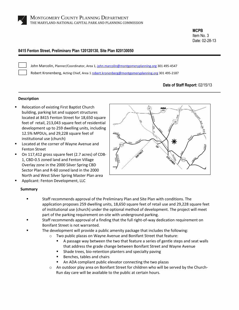
Located at the corner of Wayne Avenue and Fenton Street
On 117,412 gross square feet (2.7 acres) of CDB-1, CBD-0.5 zoned land and Fenton Village Overlay zone in the 2000 Silver Spring CBD Sector Plan and R-60 zoned land in the 2000 North and West Silver Spring Master Plan area
Applicant: Fenton Development, LLC Submitted on February 6, 2012
Summary
MONTGOMERY COUNTY PLANNING DEPARTMENT
THE MARYLAND-NATIONAL CAPITAL PARK AND PLANNING COMMISSION
MCPB Item No. 3
Date: 02-28-13
8415 Fenton Street, Preliminary Plan 120120130, Site Plan 820130050
John Marcolin, Planner/Coordinator, Area 1, [email protected] 301 495-4547
Robert Kronenberg, Acting Chief, Area 1 [email protected] 301 495-2187
Description
Date of Staff Report: 02/15/13

Page 2
TABLE OF CONTENTS
SITE DESCRIPTION 4
Vicinity 4
Site Analysis 5
PROJECT DESCRIPTION 6
Proposal 6
Land Use 7
Architecture 7
Public Amenities 9
Vehicular & Pedestrian Circulation 10
PROJECT ANALYSIS 12
Sector Plan 12
Development Standards
Environmental Guidelines
15
18
FINDINGS 22
RECOMMENDATION & CONDITIONS 36
APPENDICES 45
ILLUSTRATIONS & TABLES
Vicinity Map 4
Aerial Photograph 5
Plan Views 6
Perspective Views 7-8
On and Off-Site Public Amenity Space 9
Illustrative Landscape Plan 10
Circulation Plan 11
Shadow Studies 14

Page 3
Detailed Zoning Map 17
Tree Variance Plan 21
Table 1 24
Table 2 25
Table 3 26
Project Data Table 31

Page 4
SITE DESCRIPTION
Vicinity
The subject property is located at the northern boundary of Fenton Village at the intersection of Wayne
Avenue and Fenton Street. Downtown Silver Spring is situated north of Wayne Avenue anchored at this
intersection by the Whole Foods market and Courtyard by Marriott hotel. Sites within this section of the
Vicinity Map

Page 5
CBD are zoned primarily CBD-1 transitioning to CBD-.5 adjacent to the one-family R-60 neighborhoods
toward to the east. The adjacent uses include restaurants, salons, residential apartments, a dry
cleaner and gasoline stations. The site is within walking distance of the Silver Spring Metro Station and
across the street from the future Purple Station to be located at the new Silver Spring Library.
Site Analysis
The subject property is currently improved with the First Baptist Church of Silver Spring, comprised of a
sanctuary building with meeting rooms, a day care center, a parking lot on the south west corner of the
site and two one-family houses used by the church staff. The site slopes downward in a southeast
direction with a grade change of approximately 10 feet. At the southeast corner there are three large
deciduous trees. There is a Washington Gas line and vault within the Bonifant Street right-of-way
adjacent to the property line. The entire site consists of four zones; from Fenton Street to the east is the
CBD-1 zone, CBD-0.5 and the R-60 zone. The Fenton Village Overlay zone encompasses the CBD-1
portion of the site (see zoning map on page 13). The R-60 portion of the site (proposed Lot 2) is
Aerial Photo Looking North

Page 6
improved with a one-family dwelling presently owned by Saint Michael the Archangel Catholic Church.
PROJECT DESCRIPTION
Previous Approvals
A Project Plan (#920120020) was approved on May 31, 2012 and July 16, 2012 for 18,650 square feet of
retail, 215,660 square feet of residential development for a maximum of 259 dwelling units, including
12.5% MPDUs, and 29,228 square feet of institutional use for a religious institution. The mailing date of
the resolution is August 15, 2012.
Proposal
Preliminary Plan
The preliminary plan proposes to consolidate 12 parcels into two lots. Lot 1, with a total area of 53,824
square feet, is planned to accommodate the mixed-use portion of the project. Lot 2, with a total of
32,506 square feet, on the east side of the project will accommodate the future church building.
Site Plan
The Site Plan proposes one mixed-use multi-family apartment building on the west side of the property
(Lot 1). It will have a total gross floor area of 231,693 sf., including 18,650 sf. of retail and up to 259
dwelling units. The total number of dwelling units includes 12.5% MPDUs (33 units).
This building will sit above a structured parking facility. The building on the east side of the property (Lot
Ground Floor Mezzanine Level

Page 7
2) will house a new church sanctuary, religious education classrooms and a child day care center. It will
have a gross floor area of 29,228 square feet.
Land Use
The proposed development would provide 260,921 square feet of gross floor area for residential, retail
and church uses. There will be ground floor retail facing Fenton Street at the corners of Fenton and
Wayne and Fenton and Bonifant Street. The upper floors will contain residential uses. The sidewalks
will follow the Silver Spring Streetscape Standard while a connection between Wayne Avenue and
Bonifant Street will be composed of two public plazas and a pedestrian connector, satisfying the
minimum 20% Public Use Space requirement.
Architecture
The design of the building façade on Bonifant Street is intended to have a more traditional look that
helps integrate it with the traditional style of architecture in the one-family residential neighborhood to
the east. The building façade will incorporate brick and cast stone cornices, lintels and sills that are
Perspective View from Wayne Avenue looking southeast
typical of more traditional architecture. The façade on Wayne Avenue that faces Downtown Silver Spring
will have a contemporary design incorporating masonry metal, concrete and glass curtain wall elements.
The paving, landscaping and art in the public use space are designed and detailed to clearly indicate that
it is a space that is open to the public. The goal of the design is to activate the space by drawing the

Page 8
public in and through it.
The church building will be connected to the mixed use parking via a passage on a lower level. The
Perspective View from Wayne and Fenton Street
Perspective View from Bonifant Street

Page 9
primary pedestrian point of access to the residential units in the mixed-use building will be from Fenton
Street. The primary point of access to the church will be from Wayne Avenue. Access to the public use
spaces and the church will be from Wayne Avenue and Bonifant Street. The mixed use building will be
tallest at the corner of Wayne Avenue and Fenton Street adjacent to the taller buildings of downtown
Silver Spring. The building will step down in height towards Bonifant Street and the residential
neighborhood to the south and east. The residential building at its southeast corner on Bonifant Street
will be approximately 45’ tall. The proposed church building will be approximately 35 feet tall.
Public Use Space & Amenities
The proposed development provides 17,760 square feet of on-site public use space (22.51% of net lot
area), satisfying the 20 percent requirement or Optional Method Development projects in the CBD.
Public Use Space
Approximately 805 square feet of on-site amenity space is provided for outdoor café dining at the north
end of the paseo. An additional 1,200 square feet of amenity space is provided on site in the R-60

Page 10
portion of the project. This area is not included in either the on-site public use space calculations or in
the off-site amenity space calculations. The project provides 14,770 square feet of off-site public facility
and amenity space (17.1% of net lot area). The on-site space is primarily composed of two public plazas
and a pedestrian connection between Wayne Avenue to Bonifant Street. The off-site amenity space
requirements will be met by replacing existing concrete sidewalks with the Silver Spring Streetscape,
including brick sidewalks, trees, lighting, street furniture and the undergrounding of utilities.
Illustrative Landscape Plan
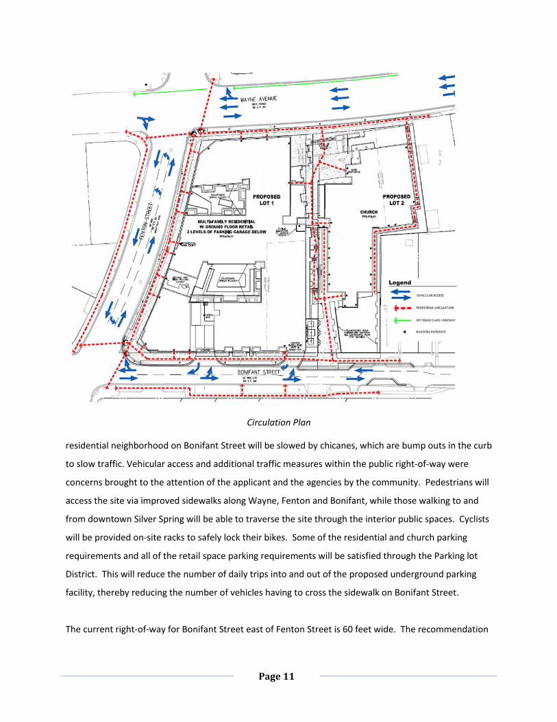
Vehicular and Pedestrian Circulation
Resident parking and loading will be accessed from Bonifant Street and existing on-street parking on
Wayne Avenue and Fenton Street will be preserved. East bound traffic entering the East Silver Spring
Page 11
Circulation Plan
residential neighborhood on Bonifant Street will be slowed by chicanes, which are bump outs in the curb
to slow traffic. Vehicular access and additional traffic measures within the public right-of-way were
concerns brought to the attention of the applicant and the agencies by the community. Pedestrians will
access the site via improved sidewalks along Wayne, Fenton and Bonifant, while those walking to and
from downtown Silver Spring will be able to traverse the site through the interior public spaces. Cyclists
will be provided on-site racks to safely lock their bikes. Some of the residential and church parking
requirements and all of the retail space parking requirements will be satisfied through the Parking lot
District. This will reduce the number of daily trips into and out of the proposed underground parking
facility, thereby reducing the number of vehicles having to cross the sidewalk on Bonifant Street.
The current right-of-way for Bonifant Street east of Fenton Street is 60 feet wide. The recommendation

Page 12
in the Sector Plan is for 80 feet on the east side and 70 feet on the west side between Fenton Street and
Georgia Avenue. The applicant has requested that the full 80-foot right-of-way on Bonifant Street not
be applied as recommended in the Silver Spring CBD Sector Plan. There is no rationale in the Silver
Spring CBD Sector Plan that justifies the expansion of the right-of-way of this section of Bonifant Street
from 60’ to 80’ wide. Given that this section of Bonifant Street is the transition point from the CBD into
the residential neighborhood it should not have an 80’ right-of-way when the section of Bonifant street
directly to the west of Fenton Street has a recommended right of way of 70’. Common sense would
indicate the opposite. To widen the right of way of this street to 80’ with the accompanying increase in
pavement width, would encourage higher automobile speeds and greater amounts of traffic at a
location where just the opposite is desired by the community. The Montgomery County Department of
Transportation supports the reduced width. Staff recommends a 60 foot right-of-way for the section of
Bonifant Street east of Fenton Street.
PROJECT ANALYSIS
Sector Plan
The CBD-1 and CBD-.5 portion of the site are located within the boundaries of the Approved and
Adopted February 2000 Silver Spring CBD Sector Plan. The Fenton Village Overlay zone overlaps with
the CBD-1 zone and is incorporated into the Sector Plan. The Sector Plan articulates six themes or goals
for the CBD that serve to guide the evaluation of development proposals (page 14). They are:
Transit oriented downtown
Commercial downtown
Residential downtown
Civic downtown
Green downtown
Pedestrian-friendly downtown
The plan is consistent with the Master Plan vision, fulfilling all six themes as described below:
1. Transit Oriented Downtown, Page 16 - The project is within walking distance of the future
multi-modal Transit Station and is across from a future Purple Line station, thereby providing
future residents with excellent access to a variety of mass transit options.
2. Commercial Downtown, Page 18 – The project will incorporate ground floor retail along the
Page 13
Fenton Street and at its intersections with Wayne and Bonifant, enlivening the streetscape in
Fenton Village with active uses where none presently exist.
3. Residential Downtown, Page 19 - The project includes 259 residential units.
4. Civic Downtown – the project will rebuild the First Baptist Church on the site, preserving this
85 year old civic use in Fenton Village.
5. Green Downtown, Page 22 – The plan provides tree lined streets and a landscaped plaza,
featuring bio-filtration planters.
6. Pedestrian-Friendly Downtown, Page 24 –Utilities will be placed underground and
improvements will be installed in compliance with the Silver Spring Streetscape Standards
The standard includes street trees, brick paving, street lights and furnishings) on the Wayne
Avenue, Fenton Street and Bonifant Street frontages.
The Sector Plan also states that the general urban design guidelines should be incorporated into
redevelopment projects in the Silver Spring CBD. Of those listed, the project satisfies the following:
Conforms to the Sector Plan, CBD-wide planning goals such as transportation, environmental
resources and the standards of a revised Silver Spring Streetscape.
Creates an attractive pedestrian environment by defining the street with appropriately human
scaled buildings with numerous doors, windows, and architectural details and public open
spaces and streetscaping.
Establishes streetscapes that emphasize the hierarchy of the circulation system.
Creates formal and informal civic spaces - building and open spaces - that support property
values, provide amenities, and improve the appearance of downtown.
Provides safe and attractive pedestrian connections between new development on the Urban
Renewal site and surrounding CBD neighborhoods, particularly Fenton Village.
Incorporates the principles of crime prevention through environmental design by stressing
visibility, pedestrian activity, and programming into the project.
Two urban design goals listed on pg. 73 of the Sector Plan, however, do not apply to this application:
The first is regarding the incorporation of historic resources in the new development. The 1950’s era
church building (First Baptist Church of Silver Spring) existing on the subject site was evaluated by the
Historic Preservation Commission (“HPC”) on March23, 2011.
The HPC decided not to designate the church either for the Locational Atlas or the Master Plan for

Page 14
Historic Preservation. On June 23, 2011 the Planning Board considered the HPC recommendation and
determined not to prepare a public hearing draft amendment to the Master Plan for Historic
Preservation. The second goal that is not achieved is the establishment of the Silver Spring Green Trail
on Wayne Avenue. This trail was installed opposite Wayne Avenue with the development of Downtown
Silver Spring.
With regard to building height and the surrounding context, numerous Sector Plan citations speak to
anticipated infill development with higher-density employment and housing and retail uses in Fenton
Village. The shade and massing relationships associated with this proposal are shown in the illustration
above. The proposed building will cast the longest shadows on Fenton Street and Wayne Avenue during
the winter months. The single family homes to the east of the proposed building will have minimum
shadows cast on them during the winter and summer months because the proposed building on the
east side of the project are limited to 35’ heights and set to the north the single family home on Bonifant
Street.
Shadow Study
Employment, Housing, & Land Use
The applicable references in the Sector Plan refer to the need for small scale retail, small office space,
new housing and pedestrian traffic in Fenton Village. The specific objectives with regard to this site are
met as indicated:

Page 15
The proposal provides small scale retail to meet market demand from surrounding
neighborhoods.
The proposal creates housing opportunities through 259 planned housing units, 33 (12.5%) of
which are MPDUs.
The design promotes an environment that supports pedestrians and activities that enliven the
street by preserving the church use, and providing retail and residential uses.
The infill development is more environmentally sustainable because it concentrates growth near
transit and the types of land uses necessary to support day-to-day needs. This reduces vehicular
travel and reduces development pressure on our and agricultural areas.
Fenton Village Overlay Zone
The project is consistent with the recommendations of the Fenton Village Overlay Zone. The Overlay
District calls for “…upgraded streetscapes, new housing and a lively mix of multi-cultural, specialty and
convenience shops serving local and regional customers…neighborhood-scale commercial uses along
Fenton Street…” (Page 60). The project meets these goals by providing ground floor retail space for
potential restaurants or convenience shops, new housing and an upgraded streetscape through the
implementation of the Silver Spring Streetscape Standards on Wayne Avenue, Fenton Street and
Bonifant Street.
North and West Silver Spring Master Plan
The most eastern part of the site is zoned R-60 as recommended in the North and West Silver Spring
Master Plan. The North and West Spring Master Plan does not make a specific recommendation for the
R-60 zoned property in question. However, it does recommend reconfirming the existing residential
zoning in North Silver Spring and recommends that new development, infill development, and special
exception uses be compatible with the existing residential character, essentially maintaining the existing
land use patterns (page 21). The proposed church use is compatible with the R-60 zone. The R-60 zone
permits the institutional use (church) and is appropriate in a residential neighborhood.
Development Standards
Master Plan Zones
The majority of the subject site is zoned CBD-1, CBD-0.5 as recommended in the Silver Spring CBD Sector

Page 16
Plan and is governed by the development standards in Section 59-C-6.21 and Section-59-C-1.32 of the
Montgomery County Zoning Ordinance. The minimum lot size of 18,000 square feet for optional method
projects is met. The CBD-1 zoned part of the site fronting onto Fenton Street is within the Fenton Village
Overlay Zone.
The project maintains compatibility with the existing residential character of the neighborhood and with
the existing land use patterns by locating the church on the east side of the project. The scale of the
church, with 35’ roof heights (per the R-60 zone), and red brick, is harmonious with the adjacent one-
family residential neighborhoods. This church will also act to buffer the neighborhood from the
commercial uses located on the western side of the site in the Silver Spring CBD. The belfry or steeple,
with an approximate height of 70’ is located in the CBD-0.5 zone of the Silver Spring CBD Sector Plan
area, thereby keeping taller structures closer to the taller buildings of Downtown Silver Spring.
In summary, the project, by locating the church in the North and West Silver Spring Master Plan area,
maintains conformance with the goals of that Master Plan by proposing new development that is
compatible with the existing residential character and land use patterns of the neighborhood to the
east.
Heights
Normal allowed height in the Fenton Village Overlay zone is 60 feet, stepping down in height to 45 feet
at the southeast corner of the site on Bonifant Street, however, the zoning code allows for an increase
above the 60 feet for projects with frontage on Wayne Avenue and Fenton Street that include
residential or a mix of residential and commercial uses. The proposed height for the residential building
along Wayne Avenue at fenton Street is 75 feet per §59-C-18.192(b) (1) (E): “ for properties with
frontage on both Wayne Avenue and Fenton Street, notwithstanding the height limitations in subsection
(b)(1) (B)-(D), may be increased by 15 feet for a building that includes residential uses or a mix of
residential and commercial uses, if such additional height is not more than 200 feet from the right-of-
way line for Fenton Street as recommended in the Approved an Adopted 2000 Silver Spring CBD Sector
Plan…”

Page 17
This allows higher densities to be concentrated on the portion of the site that is closer to downtown
Silver Spring and lower densities to be closer to the existing one-family neighborhoods to the east and
south. The proposal does not adversely affect the surrounding properties in any detrimental way given
the urban context. The proposed church building, part of which is located on R-60 property has a
proposed mean height of 35 feet with a taller belfry. According to Section 59-B-1.1 building height limits
do not apply to belfries, making a belfry taller than 35 feet exempt.
Density and uses
The project is proposing a mixed-use total density of 231,643 square feet, exclusive of the R-60 zone,
thereby meeting the density requirements of the zones. The optional method of development for
Detailed Zoning Map
Page 18
mixed use allows 257,002 gross square feet. Within the CBD zoned portions of the site, 213,043 gross
square feet are proposed for residential uses and 18,650 gross square feet are proposed for retail uses.
The CBD zones permit the residential, institutional, child day care and commercial uses proposed with
this application. The total gross square feet dedicated to church use is 29,228 gross square feet. The R-
60 zone permits the institutional (church) use within the boundaries of the R-60 zone. However, 6,852
square feet of the proposed church falls within the R-60 zone and does not figure into the density total.
Adding the density in the R-60 zone results in a density over the entire site of 260,921 gross square feet.
Setback and Coverage
The project plan satisfies the public use space requirement by providing two public plazas with the
pedestrian connector. There is no setback requirement for optional method requirements in the CBD
zone, and the application is proposing to hold the building to the property line for the portions of the
project within the CBD. The church is setback 25 feet from Wayne Avenue and 10 feet from the side lot
lines to respect the development standards of the R-60 zone. The R-60 zone does have a maximum
coverage requirement; however church uses in the R-60 zone are exempt from the requirements under
Section 59-B-4.1. As the data table shows, the project satisfies all of the development standards.
Because this project is within a Parking Lot District, parking spaces are not required, however, 267
spaces are being provided for the development. The deficient number of spaces will require payment of
a fee to the Parking Lot District.
Environmental Guidelines
Natural Resource Inventory/Forest Stand Delineation (NRI/FSD)
An NRI/FSD (420120030) was completed and approved on September 15, 2011. The NRI/FSD identified
any environmental constraints and forest resources on and near the subject property.
The NRI/FSD shows no streams or associated environmental buffers, wetlands, forests or floodplains on-
site. There are five significant trees ranging in size from 8-24 inches and 9 specimen trees 30 inches or
greater in and within 50’ of the proposed development.
Preliminary Forest Conservation Plan
A Preliminary Forest Conservation Plan was submitted on February 6th, 2012 with the project plan
application and approved by the Board. The preliminary FCP worksheet and afforestation requirements

Page 19
have not changed with the Final Forest Conservation Plan application.
Forest Conservation Plan
A Final Forest Conservation Plan (820130050) was submitted on October 23, 2012. The total net tract
area is 2.7 acres with an afforestation requirement of 0.40 acres to be met as a fee-in-lieu payment. The
property has no forest, streams or wetlands and retains three on-site specimen trees. One of the six
offsite specimen trees may need to be removed if impacts to the CRZ tree cause mortality. There will be
impacts to the critical root zones of two additional off-site specimen trees.
County Arborist’s Recommendations on the Variance
In accordance with Montgomery County Code Section 22A-21(c), the Planning Department is required to
refer a copy of the variance request to the County Arborist in the Montgomery County Department of
Environmental Protection for a recommendation prior to acting on the request. A variance was
submitted to the County Arborist on January 17th, 2012. The County Arborist issued a response
(Attachment A) to the variance request on May 24th, 2012 and recommended the variance be approved
with the condition that mitigation is provided. The variance was approved at the Project Plan hearing on
July 16, 2012.
MITIGATION for TREES SUBJECT to the VARIANCE PROVISIONS
Forest Conservation Description
Fenton Street redevelopment is 2.05 acres with additional off-site disturbance of 0.65 acres. The total
net tract disturbance is 2.7 acres.
As a result of this development, there are three on-site trees proposed for removal with significant and
potentially fatal impacts to one offsite specimen tree. Mitigation would typically be at a rate that
approximates the form and function of the trees removed. Replacement most often occurs at a ratio of
1” DBH for every 4” DBH removed, with a minimum tree replacement size of 3” in DBH or greater. For
this site, the total diameter of specimen tree removal is 126 diameter inches. At one-quarter
replacement, the Applicant would need to plant eleven (11) 3-inch caliper trees. (126 ÷ 4 = (31.5) ÷ 3”=
11 trees).
Onsite tree mitigation opportunities are restricted due to the underground parking lot, the building
layout, and the need for stormwater management. The proposed planting beds are not deep enough to
support a mature tree due to the underground parking facility. Therefore, onsite specimen tree

Page 20
mitigation is not feasible.
Forest Conservation Variance
Section 22A-12(b) (3) of Montgomery County Forest Conservation Law provides criteria that identify
certain individual trees as high priority for retention and protection. Any impact to these trees,
including removal of the subject tree or disturbance within the tree’s critical root zone (CRZ), requires a
variance. An applicant for a variance must provide certain written information in support of the
required findings in accordance with Section 22A-21 of the County Forest Conservation Law. The law
requires no impact to trees that:
a. measure 30 inches DBH or greater diameter at breast height (DBH);
b. are part of a historic site or designated with a historic structure; or
c. are designated as national, state, or county champion trees; are at least 75 percent of the diameter
of the current State champion tree of that species; or to trees, shrubs, or plants that are designated
as Federal or State rare, threatened, or endangered species.
Montgomery County Forest Conservation Law §22A-21(c) requires the Planning Board to refer a copy of
each request to the County Arborist in the Montgomery County Department of Environmental
Protection for a written recommendation prior to acting on the request. The County Arborist noted that
the applicant qualifies for a variance upon meeting the mitigation requirements for tree loss.
The applicant requested a variance on January 17th, 2012 for the removal of three onsite specimen
trees and impact one (1) offsite tree (#11) exceeding 30% to the CRZ. Based on the high chance of
mortality, MNCPPC staff requested a revised variance application be made for the removal of tree #11.
The following table identifies specimen trees (> 30” DBH) to be removed both on and offsite.
Tree # Species Diameter
(inches) Condition Disposition Location
CRZ
Impacts
(%)
#8 Robinia pseudoacacia 31" DBH Fair Remove Onsite 75.7%
#9 Liriodendron tulipifera 30" DBH Good Remove Onsite 52.5%
#10 Liriodendron tulipifera 35" DBH Good Remove Onsite 54.7%

Page 21
The following table defines the specimen trees (> 30” DBH) that will be impacted by construction due to
construction activities within their critical root zones.
Unwarranted Hardship - As per Section 22A-21, a variance may only be granted if the Planning Board
finds that leaving the requested trees in an undisturbed state would result in unwarranted hardship. In
this case, the unwarranted hardship would be due to:
This is a small lot within a CBD area and efforts have been made to reduce impacts to the trees on the
#11 Acer saccharinum 30" DBH Good Remove Offsite 38.2%
Tree # Species Diameter
(inches) Condition Disposition Location
CRZ
Impacts
(%)
#3 Acer saccharinum 56" DBH Fair/Good Save Offsite 17.8%
#4 Quercus rubra 46" DBH Good Save Offsite 26.2%
Specimen trees to be removed & CRZ
impacts.
Specimen trees with CRZ impacts
Trees to be removed
Critical Root Zones Impacted

Page 22
site. However, due to the size constraints of the lot, the intended purpose, and the underground parking
lot, the specimen trees located within the property and one on the eastern edge of the adjacent
property cannot be saved. The exhibit above shows the location of the four specimen trees (3 to be
removed with construction, 1 to be removed if it dies) proposed in the variance for removal with
impacts to the CRZ of two (2) offsite trees.
Staff Recommendation on Variance
As a result of the above findings, staff recommends the Board approval of the applicant’s request for a
variance from Forest Conservation Law to remove three (3) specimen trees with impacts to one (1)
offsite specimen tree. Should the off-site tree die (tree # 11), it too shall be removed. The variance
approval is assumed into the Planning Board’s approval of the Forest Conservation Plan.
ANALYSIS AND FINDINGS – CHAPTER 50
Preliminary Plan
Conformance to the Master Plan
The preliminary plan has been reviewed for compliance with the Montgomery County Code, Chapter 50,
the Subdivision Regulations. The proposed subdivision substantially conforms to the recommendations
adopted in the Silver Spring CBD Sector Plan. The proposed lot was reviewed for compliance with the
dimensional requirements for the CBD-0.5, CBD-1, and as modified by the Fenton Village Overlay Zone
with respect to height, and R-60 zone as specified in the Zoning Ordinance. The lot as proposed will
meet all the dimensional requirements for area, frontage, width, and setbacks in that zone. A summary
of this review is included in Table 1, below. The application has been reviewed by other applicable
county agencies, all of whom have recommended approval of the plan.
In order to approve a preliminary plan of subdivision, the Planning Board must make the following five
findings pertinent to Chapter 50:
(a) The proposed lot and associated uses comply with the recommendations of the Approved and
Adopted Sector Plan
The Preliminary Plan is consistent with the February 2000, Approved and Adopted Silver Spring CBD
Sector Plan and the August 2000 North and West Silver Spring Master Plan. The Silver Spring CBD Sector

Page 23
Plan provides for the development of Downtown Silver Spring under the following themes: Transit-
Oriented, Commercial, Residential, Civic, Green and Pedestrian Friendly. The Fenton Street project is in
line with these themes as it provides for mixed-use development (commercial and residential) with
significant public amenities in close proximity to the future Purple Line station across the street. It
furthers the Plan’s goals of creating a mix of housing choices supported by parks, retail, civic uses and
employment opportunities adjacent to transit and with convenient access to the greater region.
The North and West Spring Master Plan recommends reconfirming the existing residential zoning in
North Silver Spring and recommends that new development, infill development, and special exception
uses be compatible with the existing residential character, essentially maintaining the existing land use
patterns (page 21). The proposed church use is compatible with the R-60 zone. The R-60 zone permits
the institutional use (church) and is appropriate as a transition to a residential neighborhood. The
project maintains compatibility with the existing land use patterns by locating the church, which is
compatible with one-family residential neighborhoods, on the east side of the project. The proposed
church will act to buffer the neighborhood from the commercial uses located on the western side of the
site in the Silver Spring CBD. The belfry or steeple, with an approximate height of 70’ is located in the
CBD-0.5 zone of the Silver Spring CBD Sector Plan area, thereby keeping taller structures closer to the
taller buildings of Downtown Silver Spring.
Public Facilities
(b) Public facilities will be adequate to accommodate commercial and residential buildings containing a
total of 260,921 square feet, including 259 dwelling units and 18,650 square-feet of commercial
uses.
Roads and Transportation Facilities
Right- of- way dedication
Bonifant Street, to the south of the site, is recommended in the Sector Plan as a two-lane business
district street with a minimum right-of-way width of 80 feet between the CBD boundary (Grove
Street) to the east and Fenton Street to the west, and with a signed shared on-road local bikeway
(Route 12) between Cedar Street to the east and Capital Crescent Trail/Metropolitan Branch Trail to
the west.
The applicant proposes to not dedicate additional right-of-way for Bonifant Street because
additional right-of-way is not needed to accommodate existing or planned street improvements.

Page 24
Staff recommends approval of the elimination of the right-of-way dedication, maintaining the
existing 60 foot right-of-way on Bonifant Street to the east of Fenton Street within the Silver Spring
Sector Plan boundary since the existing 60-foot right-of-way will adequately meet the roadway,
access, pedestrian, and bicycle requirements along Bonifant Street to the east of Fenton Street
within the CBD boundary. The recommended reduction in right-of-way dedication will not have any
negative impact on traffic circulation and safety in the immediate area. The recommended
reduction in right-of-way dedication will also reduce the overall impact of this section of the
roadway on the residential community to the east. It is also noted that the right-of-way dedication
requirement for Bonifant Street, as a secondary residential street to the east of the CBD area, is
typically 60 feet and that to the west of Fenton Street, recommended as a two-lane business street,
is 70 feet. Therefore the 80 feet recommended right-of-way in the Sector Plan for the section of
Bonifant Street between Fenton Street and the eastern CBD boundary is unnecessary.
Adequate Public Facilities Review
A traffic study (dated March 23, 2012) was submitted by the consultant for the subject application
per the LATR/PAMR Guidelines since the proposed development was estimated to generate 30 or
more peak-hour trips during the typical weekday morning (6:30 a.m. – 9:30 a.m.) and evening (4:00
p.m. – 7:00 p.m.) peak periods. The traffic study determined traffic-related impacts of the proposed
development on nearby roadway intersections during weekday morning and evening peak periods.
Trip Generation
The peak-hour trip generation estimate for the proposed Fenton Street development was based on
trip generation rates included in the LATR/PAMR Guidelines. A site trip generation summary is
presented in Table 1, which shows that the proposed development would generate 87 peak-hour
trips during weekday morning peak period and 115 peak-hour trips during weekday evening peak
period.
TABLE 1 SUMMARY OF SITE TRIP GENERATION
PROPOSED FENTON STREET DEVELOPMENT
Trip Morning Peak-Hour Evening Peak-Hour
Generation In Out Total In Out Total
18,650 SF Retail 5 4 9 19 18 37

Page 25
259 Multi-Family Residential Units 16 62 78 55 23 78
Total Trips 21 66 87 74 41 115
Weekday peak-hour trips associated with the existing church and the day care center, which are
being replaced on the site, were considered to be part of the existing traffic and therefore not
counted again in the site trip generation estimates. It is also noted that houses of worship are
excluded from APF determination.
Local Area Transportation Review
A summary of the capacity analysis/Critical Lane Volume (CLV) analysis results for the study
intersections for the weekday morning and evening peak-hours within the respective peak periods
from the traffic study are presented in Table 2.
TABLE 2 SUMMARY OF CAPACITY CALCULATIONS
PROPOSED FENTON STREET DEVELOPMENT
: Source: The Traffic Group, Inc. Traffic Impact Analysis for Fenton Street; March 23, 2012.
As shown in Table 2, under Total (Build) traffic conditions, CLV values for intersections included in
Intersection
Traffic Conditions
Existing Background Total
AM PM AM PM AM PM
Georgia Ave/Bonifant St 779 672 869 782 907 819
Georgia Ave/Thayer Ave 663 713 744 821 754 833
Fenton St/Thayer Ave 688 795 817 953 824 961
Fenton St/Bonifant St 560 704 683 861 746 921
Fenton St/Wayne Ave 788 827 922 968 931 997
Bonifant St/Cedar St/Houston St1 182 385 204 410 204 410
Bonifant St/Site Access Driveway -- -- -- -- 136 205
Silver Spring CBD Policy Area Congestion Standard: 1,800 CLV Silver Spring/Takoma Park Policy Area Congestion Standard: 1,600 CLV 1 Intersection located within the Silver Spring/Takoma Park Policy Area

Page 26
the study were estimated to be below the respective Silver Spring CBD Policy Area and Silver
Spring/Takoma Park Policy Area congestion standards (1,800 CLV and 1,600 CLV, respectively).
Based on this analysis, the subject application satisfies the LATR requirements of the APF test.
Policy Area Mobility Review
To satisfy the PAMR requirements of the APF test, and per the policy in place that offer a PAMR trip
credit for CBD developments, a development located within the Silver Spring CBD Policy Area is
required to mitigate 5 percent (5%) of “new” peak-hour trips generated by the development using
Countywide trip generation rates, and is then offered a credit on the PAMR trip mitigation
requirement equivalent to any reduction in peak-hour trips achieved by the development as a result
of its location within the CBD. A summary of the PAMR calculations for the proposed development is
presented in Table 3.
TABLE 3
PAMR MITIGATION REQUIREMENT CALCULATION
PROPOSED FENTON STREET DEVELOPMENT
Morning Peak-Hour Evening Peak-Hour
A. Proposed Density – (Countywide Rates)
Residential – 259 HRDU’s 86 100
Retail – 18,650 SF 34 135
Pass-by trips (40% of retail) 14 54
Primary trips (60% of retail) 20 81
Total “New” Trips (A1) 106 181
B. PAMR Mitigation Requirement (B1 = A1 x 0.05) 5 9
C. Proposed Density – (CBD Rates)
Residential – 259 HRDU’s 78 78
Retail – 18,650 SF 9 37
Total “New” Trips (C1) 87 115
Trip Credit for CBD Location

Page 27
D. Trip Credit (D1 = A1 – C1) 19 66
Adjusted PAMR Mitigation Requirement
E. (E1 = D1 – B1) +14 +57
[PAMR: Excess/Pass = +ve; Deficit/Fail = -ve] (Pass PAMR) (Pass PAMR)
As shown in Table 3, using Countywide trip generation rates, the density proposed on the site would
generate 106 “new” peak-hour trips during the weekday morning peak period and 181 “new” peak-
hour trips during the weekday evening peak period (Line A1). With the requirement to mitigate 5%
of the “new” peak-hour trips, the PAMR mitigation requirement for the development are 5 peak-
hour trips during the weekday morning peak period and 9 peak-hour trips during the weekday
evening peak period (Line B1).
Using the Silver Spring CBD trip generation rates, as shown in Table 3 and Table 1, the density
proposed on the site would generate 87 “new” peak-hour trips during the weekday morning peak
period and 115 “new” peak-hour trips during the weekday evening peak period (Line C1).
The PAMR CBD trip credit, which is the difference in “new” trips between the Countywide and CBD
trip generation for the density proposed on the site, are 19 peak-hour trips during the weekday
morning peak period and 66 peak-hour trips during the weekday evening peak period (Line D1).
With the above credits, it is seen that the PAMR mitigation requirement for the proposed
development is fully mitigated during the morning peak-hour (5 trip PAMR mitigation requirement
vs. 19 trip CBD PAMR credit) as well as during the evening peak-hour (9 trip PAMR mitigation
requirement vs. 66 trip CBD PAMR credit) (Line E1).
Based on the above analysis, the subject application satisfies the PAMR requirements of the APF
test.
Other Public Facilities and Services Public facilities and services are available and will be adequate to serve the proposed development.
The property is proposed to be served by public water and public sewer. The application has been
reviewed by the Montgomery County Fire and Rescue Service who has determined that
consideration of a depressed curb along Wayne Avenue in front of the public plaza and a load
bearing access area on the public sidewalk might be appropriate to satisfy safety concerns. Final

Page 28
details to be approved at time of building permit. Other public facilities and services, such as police
stations, firehouses, and health services are operating according to the Subdivision Staging Policy
resolution currently in effect and will be adequate to serve the property. The subject property is
within the Northwood High School cluster area, which is currently operating between 105-120% of
capacity at the high school level, and a school facilities payment is not required. Electrical,
telecommunications, and gas services are also available to serve the property.
Environment
(c) The Applicant proposes to record 2 lots with a net lot area of 53,829 square feet for Lot 1 and 32,506
square feet for lot 2 after right-of-way dedication for Fenton Street and Wayne Avenue. The lot size,
width, shape and orientation are appropriate. A preliminary forest conservation plan has been
submitted and approved that satisfies all the applicable requirements of the Chapter 22A.
(d) A preliminary forest conservation plan has been submitted and approved that satisfies all the
applicable requirements of the Chapter 22A.
Natural Resource Inventory/Forest Stand Delineation (NRI/FSD)
An NRI/FSD (420120030) was completed and approved on September 15, 2011. The NRI/FSD identified
any environmental constraints and forest resources on and near the subject property.
The NRI/FSD shows no streams or associated environmental buffers, wetlands, forests or floodplains on-
site. There are five significant trees ranging in size from 8-24 inches and 9 specimen trees 30 inches or
greater in and within 50’ of the proposed development.
Preliminary Forest Conservation Plan
A Preliminary Forest Conservation Plan was submitted on February 6th, 2012 with the project plan
application. The preliminary FCP worksheet and afforestation requirements have not changed with the
Final Forest Conservation Plan application.
Final Forest Conservation Plan

Page 29
A Final Forest Conservation Plan (820130050) was submitted on October 23, 2012. The total net tract
area is 2.7 acres with an afforestation requirement of 0.40 acres to be met as a fee-in-lieu payment.
The property has no forest, streams or wetlands and retains three specimen trees. One offsite
specimen tree may be removed if impacts to the CRZ tree cause mortality. There will be impacts to the
critical root zones of two additional off-site specimen trees.
Section 22A-21 of the County Forest Conservation Law sets forth the findings that must be made by the
Planning Board or Planning Director, as appropriate, in order for a variance to be granted. Staff has
made the following determinations in the review of the variance request and the proposed forest
conservation plan:
(a) Will not confer on the applicant a special privilege that would be denied to other applicants:
The property is located predominantly within the CBD of Silver Spring under the Optional
Method of development. The Project Plan was approved on July 16th, 2012 which maximizes
density and use of the site as recommended in the Silver Spring Master Plan.
(b) Is based on conditions or circumstances which are the result of the actions by the applicant.
The requested variance is based on the need to maximize development within the CBD zones.
The proposed plan would not be feasible if the square footage of the lot were restricted to save
the existing trees.
(c) Arises from a condition relating to land or building use, either permitted or non-conforming, on a
neighboring property.
The requested variance is a result of the proposal which promotes an efficient site design and
layout for the subject property and not as a result of land or building use on a neighboring
property.
(d) Will violate State water quality standards or cause measurable degradation in water quality.
There will be a few small planting beds onsite that will provide both vegetation and amended
soil volumes. The vegetation will aid in cooling surface temperatures within the immediate area,
aid in carbon sequestration, and provide pollination opportunities.
The proposed bio-retention facilities will improve runoff quality and quantity by filtering,
cooling, utilizing, and slowly releasing stormwater into the storm drain network.

Page 30
Stormwater Management
The MCDPS Stormwater Management Section conditionally approved the Stormwater Management
Concept for the Application July 10, 2012. The stormwater management concept consists of a waiver of
on-site channel protection measures due to existing shallow storm drain inverts. On-site water quality
control will be met via green roots, and bio-filtration systems.
Compliance with the Subdivision Regulations and Zoning Ordinance
This application has been reviewed for compliance with the Montgomery County Code, Chapter 50, the
Subdivision Regulations. The application meets all applicable sections. The proposed subdivision
substantially conforms to the recommendations adopted in the Master Plan. The lots were reviewed for
compliance with the dimensional requirements for the CBD-0.5, CBD-1 zones, and as modified by the
Fenton Village Overlay zone for building height, and the R-60 zone, as specified in the Zoning Ordinance.
The lots as proposed will meet all the dimensional requirements for area, frontage, width, and setbacks
in that zone. A summary of this review is included in attached Table 1. The application has been
reviewed by other applicable county agencies, all of whom have recommended approval of the plan.
Citizen Correspondence and Issues The applicant has met with nearby residents and with representatives of the East Silver Spring Citizens
Association (ESSCA). A pre-application meeting was held on August 28, 2012. The meeting was attended
by 15 members of the community. The architect presented the project to the community and explained
how the proposed facades and buildings heights will be compatible with Bonifant Street and the one-
family home to the immediate southeast. The building and façade designs were well received by the
community. Citizen concerns have been adequately addressed by the recommended changes.
CONCLUSION The proposed lots meet all requirements established in the Subdivision Regulations and the Zoning
Ordinance and substantially conform to the recommendations of the Silver Spring CBD Sector Plan.
Access and public facilities will be adequate to serve the proposed lots, and the application has been
reviewed by other applicable county agencies. Therefore, approval of the application with the
conditions specified above is recommended.

Page 31
Site Plan
1. The site plan conforms to all non-illustrative elements of a development plan or diagrammatic plan,
and all binding elements of a schematic development plan, certified by the Hearing Examiner under
Section 59-D-1.64, or is consistent with an approved project plan for the optional method of
development, if required, unless the Planning Board expressly modifies any element of the project
plan.
The site plan is consistent with the approved Project Plan 920110010 in every respect, including
density, public use space, scope and design.
2. The site plan meets all of the requirements of the zone in which it is located, and where applicable
conforms to an urban renewal plan approved under Chapter 56.
The residential, retail and institutional uses are allowed in the CBD-1 and CBD 0.5 Zones and the
Fenton Village Overlay Zone. The R-60 Zone permits the institutional and residential uses.. The
building is 75 feet tall at the corner of Wayne Avenue and Fenton Street, stepping down to 45 feet
at the southeast corner of the property, closest to the existing single family neighborhood located
here. The application is providing over 39 percent of the net lot area toward public use space,
facilities and amenities, of which over 22 percent will be on-site public use space. The CBD zones
as part of the optional method of development does not require setbacks and is not providing
setbacks, however the R-60 zone requires development standards that are satisfied with this
application. The site plan fulfills the purposes of the zone by providing residential development
compatible with adjacent residential and commercial uses in the Silver Spring Central Business
District.
Project Data for the CBD-1, CBD-0.5 & R-60 Zones
Development Standard Permitted/ Required Proposed for
Approval and Binding
on the Applicant
Building Height (feet)

Page 32
CBD-Zone-59-C-18.192(b)(1)(E) 75 75
CBD-Zone-FVOZ 60 60/45
R-60 35 35
Setbacks (feet)
CBD-1 & CBD-0.5
Front (Wayne Ave) n/a 0
Front (Fenton Street) n/a 0
Front (Bonifant Street) n/a 0
R-60
Front (Wayne Ave) 25 25
Side East 8 and10 with a total of 18 10
Site Area (square feet)
Net lot Area n/a 86,335
Previous Dedications n/a 27,989
Dedications this plan n/a 3,088
Gross Tract Area 18,000 117,412
Density
CBD-1: Floor Area Ratio 3.0 3.05
Allowable S.F. 189,885 192,965
CBD-0.5: Floor Area Ratio 1.5 0.87
Allowable S.F. 67,117 38,728
Total CBD Density: 257,002 231,643
R-60 N/A 6,852
Total Project Density 257,002 260,921
Combined FAR across CBD-1 and CBD-0.5 zones: 2.378 2.359
Public Use Space (% of net lot)
On-Site Public Use Space 20 22.51
Off-Site Public Facility and Amenity Space n/a 17.10
Total Public Use, Facility & Amenity Space 20 39.64
Parking
MPDUs
Efficiencies: 8 4
One bedroom units: 19 12

Page 33
*No Parking is required for this site as it is located in the Silver Spring parking lot district. Total number of spaces will
be determined at certified site plan.
3. The locations of buildings and structures, open spaces, landscaping, recreation facilities, and
pedestrian and vehicular circulation systems are adequate, safe, and efficient.
The buildings are located on the site to create a consistent street wall on Wayne Avenue, Fenton
Street and Bonifant Street. They frame the proposed public plaza and paseo or pedestrian pass-
thru between Wayne Avenue and Bonifant Street.
The buildings and structures of the proposed development are located on the Property line and
step down in height towards the one-family neighborhood to the southeast, which is appropriate
for the character envisioned by the Master Plan. There is easy access to the building from
adjoining sidewalks and parking. The locations of the buildings and structures are adequate and
efficient, while meeting the aesthetic concerns of the area, and do not pose any safety concerns on
the site.
The open space that is provided is 18, 375 square feet in size, not including the 1200 square feet
located in the R-60 zone. It serves the church community by providing a public gathering space in
the plaza facing Wayne Avenue while also providing a convenient short cut for pedestrians
traveling between Bonifant Street and Wayne Avenue. Landscaping provides shade trees and
Two bedroom units: 6 5
Market Rate units:
Efficiencies: 56 56
One bedroom units: 129 162
Two bedroom units: 41 62
Total Residential Parking 301 252
Retail Parking
18,650 sf @3.5 sp/1000 sf
66 0
Church Parking
1 space per 4 seats x.07 if within 500’ of public lot
128 16
Total Vehicle Spaces 495 268*

Page 34
planters with ornamental plantings that will be used for stormwater management. Public art,
composed of art wall at the transformer enclosure, art glass in the stairs between the two plazas
and a large dichromatic art glass sculpture will create an interesting focal point in the public use
space and help draw people into it are no recreation facilities required for the institutional and
commercial uses on. However, a tot lot on the south side of the project facing Bonifant Street
provides recreation opportunities for children using the day care that will be operated by the
church. The tot lot will be open to the public during non-day care hours. Additional recreation
facilities will be provided for the residents including an indoor fitness facility, community room and
pool to satisfy the recreation guidelines. The recreation facilities exceed the minimum percentage
required for each age group and are adequate, safe and efficient.
Demand
D1 D2 D3 D4 D5
Number of Units
Tots Children Teens Adults Seniors
Housing Type 0 to 4 5 to 11 12 to 17 18 to 64 65+
HIGH RISE 259 9.1 10.4 10.4 198.9 119.1
On-Site Supply
D1 D2 D3 D4 D5
Quantity Provided
Tots Children Teens Adults Seniors
Recreation Facility 0 to 4 5 to 11 12 to 17 18 to 64 65+
Picnic/Sitting 4 4.0 4.0 6.0 20.0 8.0
Tot lot 1 9.0 2.0 0.0 4.0 1.0
Pool 1 0.5 2.1 2.1 49.7 17.9
Pedestrian System 1 0.9 2.1 2.1 89.5 53.6
Community Room 1 0.9 1.6 1.0 59.7 47.7
Indoor Fitness Facility 1 0.0 1.0 1.0 39.8 17.9
total: 15.3 12.8 12.2 262.7 146.1
Adequacy of Facilities D1 D2 D3 D4 D5
a. Gross Total Supply 18.2 40.4 42.8 410.62 203.7
b. % Demand met on
site 201 389.6 433.5 206.2 170.9
e. 90% Demand 8.19 9.36 9.36 179.01 107.19
f. Adequate? yes yes yes yes yes

Page 35
In the public right-of-way street trees and lighting are provided to enhance the pedestrian
environment. Lighting in the public plaza will create enough visibility to provide safety. The open
spaces, landscaping, and site details adequately and efficiently address the needs of the proposed
use and the recommendations of the Master Plan, while providing a safe and comfortable
environment.
Pedestrian access from adjacent sidewalks adequately and efficiently integrates this site into the
surrounding area. Safety is enhanced by several improvements: There is a green panel between
the sidewalk and the major building access points on Fenton Street and Wayne Avenue. These
planted panels will discourage pedestrians from making dangerous mid-block crossings at these
points. The vehicular circulation design efficiently directs traffic into and through the site with
minimal impacts to pedestrian circulation. This balance of design with the site, the
recommendations of the Master Plan, and the needs of the use is an efficient and adequate means
to provide a safe atmosphere for pedestrians, cyclists, and vehicles.
4. Each structure and use is compatible with other uses and other site plans and with existing and
proposed adjacent development.
The proposed mixed-use development is compatible with the existing and proposed adjacent and
confronting uses. The multi-family residential uses and ground floor retail reflect the land use
pattern along Fenton Street.
The structures themselves are in scale with the nearby buildings and are located such that they will
not adversely impact existing or proposed adjacent uses. The taller buildings occupy the outer
edges of the site along Fenton Street and Wayne Avenue, adjacent to the taller buildings across
Wayne Avenue in the CBD core. The building heights step down to be more in scale with the one-
family homes to the southeast.
5. The site plan meets all applicable requirements of Chapter 22A regarding forest conservation,
Chapter 19 regarding water resource protection, and any other applicable law.
An NRI/FSD (420120030) was completed and approved on September 15, 2011. A Final Forest

Page 36
Conservation Plan is conditioned for approval as part of this review. The total net tract area is 2.7
acres with an afforestation requirement of 0.40 acres to be met as a fee-in-lieu payment.
The property has no forest, streams or wetlands and retains three specimen trees. On offsite
specimen tree may be removed if impacts to the CRZ tree cause mortality. There will be impacts to
the critical root zones of two additional off-site specimen trees.
The MCDPS Stormwater Management Section approved the Stormwater Management Concept for
the Application July 10 2012, The stormwater management concept consists of a waiver of on-site
channel protection measures due to existing shallow storm drain inverts. On-site water quality
control will be met via green roots, and bio-filtration systems.
PRELIMINARY PLAN RECOMMENDATION AND CONDITIONS
Preliminary Plan Conditions
The Preliminary Plan meets all requirements established in the Subdivision Regulations and it is in
substantial conformance with the recommendations of the Master Plan. Staff recommends approval of
Preliminary Plan 120120130 and associated final forest conservation plan, subject to the following
conditions:
1. Total development is limited to 2 lots for a maximum of 259 residential dwelling units, 18,650
square feet of commercial uses, and 29,228 square feet of institutional use (church). A minimum of
12.5% of the total number of dwelling units must be Moderately Priced Dwelling Units.
2. The Applicant must comply with the conditions of approval for the Final Forest Conservation Plan
(820130050) approved as part of this Preliminary Plan, subject to: Board approval of the applicant’s
request for a variance from Forest Conservation Law to remove three specimen trees with impacts
to one offsite specimen tree and its potential removal should the tree not survive impacts . The
variance approval is assumed into the Planning Board’s approval of the Forest Conservation Plan.
3. The Certified Final Forest Conservation Plan must include the following:
a) The Applicant must obtain approval of a Final Forest Conservation Plan from the Planning
Department prior to issuance of a Sediment Control Permit from the Department of Permitting
Services. The Final Forest Conservation Plan must be consistent with the approved Preliminary
Forest Conservation Plan.

Page 37
b) A fee-in-lieu which satisfies the 0.40 acre afforestation requirement must be submitted by the
Applicant and approved by M-NCPPC staff prior to any clearing, grading or construction activity
within the project area.
c) The Final Forest Conservation plan must be signed by the plan preparer and the Applicant must
provide and sign the developer’s certificate.
4. The Applicant must provide analysis and attenuate for any noise levels exceeding those
recommended by the Planning Boards Noise Guidelines for interior levels.
5. The sediment and erosion control plan and stormwater management plan must be submitted with
the revised Final Forest Conservation Plan to ensure consistency with the Limits of Disturbances
(LOD’s) and the associated tree preservation measures.
6. The Applicant must satisfy all conditions prior to Montgomery County Department of Permitting
Services (MCDPS) issuance of sediment and erosion control permits.
7. The Applicant must dedicate and show on the final record plat the following rights-of-way along
the property frontage consistent with the 2000 Approved and Adopted Silver Spring CBD Sector
Plan and as modified below:
1. Wayne Avenue – minimum of 40 feet from the roadway right-of-way centerline,
2. Fenton Street – minimum of 40 feet from the roadway right-of-way centerline, and
3. Bonifant Street – minimum of 30 feet from the roadway right-of-way centerline in-lieu-of
the standard 40 feet recommended by the Master Plan.
8. The Applicant must execute a Public Improvement Easement Agreement over the area that would
have been required for standard truncation at the corner of Wayne Avenue and Fenton Street with
Montgomery County Department of Transportation (DOT) prior to the release of any building
permit for the proposed development, to allow DOT to construct, modify, and maintain the
sidewalk within the truncation area in the future.
9. The Applicant must enter into a Traffic Mitigation Agreement (“Agreement”) with the Planning
Board and Montgomery County Department of Transportation (MCDOT) to participate in the Silver
Spring Transportation Management District (TMD). The Applicant must execute the Agreement
prior to the release of any building permit for the proposed development.
10. The Applicant must dedicate all road rights-of-way to the full width mandated by the Silver Spring
CBD Sector Plan with the exception of Bonifant Street per #5 above.
11. Prior to recordation of the plat(s) the Applicant must satisfy MCDPS requirements to ensure the
construction of a minimum 15 foot wide sidewalk along the property frontage on Wayne Avenue,

Page 38
Fenton Street and Bonifant Street, unless construction is waived by MCDPS.
12. The Planning Board has accepted the recommendations of the Montgomery County Department of
Permitting Service (“MCDPS”) – Water Resources Section in its stormwater management concept
letter dated July 10, 2012, and does hereby incorporate them as conditions of the Preliminary Plan
approval. Therefore, the Applicant must comply with each of the recommendations as set forth in
the letter, which may be amended by MCDPS – Water Resources Section provided that the
amendments do not conflict with other conditions of the Preliminary Plan approval.
13. The Planning Board has accepted the recommendations of the Montgomery County Department of
Transportation (“MCDOT”) in its letter dated February 15, 2013, and does hereby incorporate them
as conditions of the Preliminary Plan approval. Therefore, the Applicant must comply with each of
the recommendations as set forth in the letter, which may be amended by MCDOT provided that
the amendments do not conflict with other conditions of the Preliminary Plan approval.
14. The Applicant must enter into a Traffic Mitigation Agreement (“TMAg”) with the Planning Board
and DOT to participate in the Silver Spring Transportation Management District (TMD) and must
execute the TMAg prior to the release of any residential building permit for development on the
site. The TMAg must include those trip mitigation measures recommended by MCDOT, except as
modified herein.
15. Prior to recordation of plat(s), the Applicant must satisfy the provisions for access and
improvements as required by MCDOT.
16. Prior to recordation of any plat, Site Plan No. 8201300050 must be certified by MNCPPC Staff.
17. The record plat must show necessary easements.
18. Final approval of the number and location of buildings, on-site parking, site circulation, and
sidewalks will be determined at site plan.
19. No clearing, grading or recording of plats prior to certified site plan approval.
20. The certified Preliminary Plan must contain the following note:
Unless specifically noted on this plan drawing or in the Planning Board conditions of approval, the
building footprints, building heights, on-site parking, site circulation, and sidewalks shown on the
Preliminary Plan are illustrative. The final locations of buildings, structures and hardscape will be
determined at the time of site plan approval. Please refer to the zoning data table for development
standards such as setbacks, building restriction lines, building height, and lot coverage for each lot.

Page 39
Other limitations for site development may also be included in the conditions of the Planning Board’s
approval.
21. The Adequate Public Facility (APF) review for the Preliminary Plan will remain valid for eighty-five
(85) months from the date of mailing of the Planning Board Resolution.
22. The subject property is within the Northwood High School cluster area, which is currently operating
between 105-120% of capacity at the high school level, and a school facilities payment is required.
23. The Applicant must make a School Facilities Payment to MCDPS at the high school level at low-rise
w/structured parking unit rates for all units for which a building permit is issued and a School
Facilities Payment is applicable. The timing and amount of the payment will be in accordance with
Chapter 52 of the Montgomery County Code.
SITE PLAN RECOMMENDATIONS AND CONDITIONS
Staff recommends approval of site plan 820130050 and the associated final forest conservation plan,
Fenton Street, for 18,650 square feet of retail, 213,043 square feet of residential, including 259 multi-
family dwelling units including 12.5% MPDUs and 29,228 square feet of institutional use (church) on
2.70 acres. All site development elements shown on the site and landscape plans stamped “Received”
by the M-NCPPC on January 10, 2013 are required except as modified by the following conditions.
Conformance with Previous Approvals
1. Project Plan Conformance
The proposed development must comply with the conditions of approval for Project Plan
920120020 as listed in the Planning Board resolution dated August 15, 2012.
a. 22.51% Public use space (on-site and off-site facilities and amenities).
b. Silver Spring Streetscape standards for Wayne Avenue, Fenton Street and Bonifant Street.
c. Public Art consisting of dichromatic glass risers in the stairs between the upper and
lower plaza and a 25-30 foot dichromatic glass sculpture.
Environment
2. Forest Conservation
The Applicant must obtain approval of a Final Forest Conservation Plan from the Planning
Department prior to issuance of a Sediment Control Permit from the Department of Permitting
Services. The Final Forest Conservation Plan must be consistent with the approved Preliminary
Forest Conservation Plan. The Applicant has approval to remove three onsite with the potential to

Page 40
remove one offsite specimen tree.
3. Stormwater Management
The proposed development is subject to Stormwater Management Concept approval conditions
dated July 10, 2012 unless amended and approved by the Montgomery County Department of
Permitting Services. The sediment and erosion control plan and stormwater management plan must
be submitted with the revised Final Forest Conservation Plan to ensure consistency with the Limits
of Disturbances (LODs) and the associated tree/forest preservation measures.
4. LEED Certification
The Applicant must achieve a LEED (Leadership in Energy and Environmental Design) Certified Rating
Certification at a minimum. The Applicant must make good faith efforts to achieve a LEED Silver
rating. Before the issuance of any use and occupancy certificate, the Applicant must inform M-
NCPPC staff of the LEED Certification Level for which they are applying. If this level is less than a
Silver rating, before the issuance of the final use and occupancy certificate the Applicant must
provide to staff a written report for public record purposes only from the Applicant’s LEED
consultant analyzing the feasibility of achieving a LEED-Silver rating, to include an affidavit from a
LEED-Accredited Professional identifying the minimum additional improvements required to achieve
the LEED Silver rating, including their associated extra cost. Submission of this report constitutes
compliance with this condition.
Parks, Open Space, & Recreation
5. Recreation Facilities
a. Meet the square footage requirements for all of the applicable proposed recreational elements
and demonstrate on the certified site plan that each element is in conformance with the
approved M-NCPPC Recreation Guidelines.
b. At a minimum, provide the following recreation facilities: four picnic/sitting areas, tot lot, pool,
a pedestrian system, indoor community room, and an indoor fitness facility.
6. Maintenance of Public Amenities
The Applicant is responsible for maintaining all publicly accessible amenities including, but not
limited to, tot lot, all plantings, steps, paving, handrails, public elevator, public art and stormwater

Page 41
recharge areas. The applicant is also responsible for maintaining the public elevator that will provide
wheelchair access between the upper and lower plaza (public use space).
Density & Housing
7. Moderately Priced Dwelling Units (MPDUs)
a. The proposed development must provide 12.5 percent MPDUs of the total number units on-site
in accordance with the letter from the Department of Housing and Community Affairs to M-
NCPPC dated February 4, 2013.
b. The MPDU agreement to build shall be executed prior to the release of any residential building
permits.
c. All of the required MPDUs must be provided on site.
Site Plan
8. Site Design
a. The exterior architectural character, proportion, materials, dimensions and articulation must be
substantially similar to the schematic elevations shown on Sheets A 1.04-A1.05 of the submitted
architectural drawings, as determined by the M-NCPPC Area 1 staff.
b. Church architectural plans and engineering plans to be coordinated with grading plan shown on
the landscape architecture plans received January 28, 2013 by time of Certified Site Plan.
9. Landscaping
a. Provide proposed landscaping per plan, sheets L1.00-L4.10. Applicant to install all trees, shrubs
and perennials per approved plans. All hardscape features including walls, steps, planters,
retaining walls, and fencing to be installed per above plans.
b. The Applicant must provide a green panel between the street trees in front of the residential
entry on Fenton Street and in front of the Church entry on Wayne Avenue.
10. Private Lighting
a. The lighting distribution and photometric plan with summary report and tabulations must
conform to IESNA standards for residential/commercial development.
b. All onsite down - light fixtures must have house-side shields towards residential windows.
Page 42
c. House-side shields shall be installed on all fixtures causing potential glare or excess illumination
on any perimeter fixtures abutting the adjacent residential properties.
d. Illumination levels shall not exceed 0.5 foot candles (fc) at any property line abutting residential
properties.
e. The height of the on-site light poles shall not exceed 12 feet including the mounting base.
11. Public Art and Amenities
a. Provide for and install the public art concept designed by Studio William Cochran, as presented
to the Planning Department’s Art Review Panel on January 30, 2013, and illustrated in the
Certified Site Plan.
b. Any significant changes to the concept presented on January 30, 2013 must be presented to the
Art Review Panel and approved by Development Review staff before Certified Site Plan.
c. Significant changes to the concept, as determined by Development Review staff, proposed after
Certified Site Plan will require a Site Plan Amendment.
d. The Applicant must provide a public elevator must be installed in the public use space between
Wayne Avenue and Bonifant Street to accommodate handicap access.
12. Surety
Prior to issuance of first building permit within each relevant phase of development, Applicant must
provide a performance bond(s) or other form of surety in accordance with Section 59-D-3.5(d) of the
Montgomery County Zoning Ordinance with the following provisions:
a. Applicant must provide a cost estimate of the materials and facilities, which, upon staff
approval, will establish the initial surety amount.
b. The amount of the bond or surety shall include plant material, on-site lighting, recreational
facilities, site furniture, and entrance piers within the relevant phase of development.
c. Prior to issuance of the first building permit, Applicant must enter into a Site Plan Surety &
Maintenance Agreement with the Planning Board in a form approved by the Office of General
Counsel that outlines the responsibilities of the Applicant and incorporates the cost estimate.
d. Bond/surety shall be tied to the development program, and completion of plantings and
installation of particular materials and facilities covered by the surety for each phase of
development will be followed by inspection and reduction of the surety.

Page 43
13. Development Program
The Applicant must construct the proposed development in accordance with a development
program that will be reviewed and approved prior to the approval of the Certified Site Plan. The
development program must include the following items in its phasing schedule:
a. Street lamps and sidewalks must be installed within six months after street construction is
completed. Street tree planting may wait until the next growing season.
a. On-site amenities including, but not limited to, sidewalks, benches, trash receptacles, and
bicycle facilities must be installed prior to release of a use and occupancy permit.
b. Clearing and grading must correspond to the construction phasing to minimize soil erosion and
must not occur prior to approval of the Final Forest Conservation Plan, Sediment Control Plan,
and M-NCPPC inspection and approval of all tree-save areas and protection devices.
c. The development program must provide phasing for installation of on-site landscaping and
lighting.
d. Community-wide pedestrian pathways and recreation facilities, including the paseo and the tot
lot, must be completed prior to issuance of the final use and occupancy permit for the church.
e. Landscaping associated with each parking lot and building shall be completed as construction of
each facility is completed.
f. The development program must provide phasing of dedications, stormwater management,
sediment and erosion control, afforestation, trip mitigation, and other features.
14. Certified Site Plan
Prior to approval of the Certified Site Plan the following revisions must be made and/or information
provided subject to Staff review and approval:
a. Include the final forest conservation approval, stormwater management concept approval,
development program, inspection schedule, and site plan resolution on the approval or cover
sheet.
b. Add a note to the site plan stating that “M-NCPPC staff must inspect all tree-save areas and
protection devices prior to clearing and grading”.
c. Modify data table to reflect development standards enumerated in the staff report.
d. Ensure consistency off all details and layout between site plan and landscape plan.
e. Plans for proposed church to be reconciled with engineering and landscape architecture plans.
Page 44
APPENDICES
Appendix A: Section 59-D-2.43
Appendix B: Preliminary Plan Data Table and Checklist
Appendix C: Agency Letters

Page 45
Appendix A
According to Section 59-D-2.43 of the Montgomery County Ordinance, in reaching its determination on a project plan the Planning Board must consider the following:
(a) The nature of the proposed site and development, including its size and shape, and the proposed
size, shape, height, arrangement and design of structures, and its consistency with an urban renewal plan approved under chapter 56.
(b) Whether the open spaces, including developed open space, would serve as convenient areas for
recreation, relaxation and social activities for the residents and patrons of the development and are planned, designed and situated to function as necessary physical and aesthetic open areas among and between individuals structures and groups of structures, and whether the setbacks, yards and related walkways are located and of sufficient dimensions to provide for adequate light, air, pedestrian circulation and necessary vehicular access.
(c) Whether the vehicular circulation system, including access and off-street parking and loading, is designed to provide an efficient, safe and convenient transportation system.
(d) Whether the pedestrian circulation system is located, designed and of sufficient size to conveniently
handle pedestrian traffic efficiently and without congestion; the extent to which the pedestrian circulation system is separated from vehicular roadways so as to be safe, pleasing and efficient for movement of pedestrians; and whether the pedestrian circulation system provides efficient, convenient and adequate linkages among residential areas, open spaces, recreational areas, commercial and employment areas and public facilities.
(e) The adequacy of landscaping, screening, parking and loading areas, service areas, lighting and signs,
in relation to the type of use and neighborhood.
(f) The adequacy of provisions for construction of moderately priced dwelling units in accordance with chapter 25a if that chapter applies.
(g) The staging program and schedule of development. (h) The adequacy of forest conservation measures proposed to meet any requirements under chapter
22a. (i) The adequacy of water resource protection measures proposed to meet any requirements under
chapter 19.
(j) Payment of a fee acceptable to the Planning Board may satisfy all or some of the requirements for any public use space, or public facilities and amenities under the requirements established elsewhere in this Section.

Page 46
Appendix B:
Preliminary Plan Data Table and Checklist
Plan Name: Fenton Street
Plan Number: 120120130
Zoning: CBD-0.5, CBD-1, R-60 and Fenton Village Overlay Zone
# of Lots: 2
# of Outlots: 0
Dev. Type: Optional
PLAN DATA Zoning Ordinance
Development
Standard
Proposed for
Approval the
Preliminary Plan
Verified Date
Minimum Lot Area 18,000 s.f. 53,829 s.f. &
32,506 s.f.
JM 2-15-13
Minimum Public
Use Space 20% 22.51%
JM 2-15-13
Height 75’ 70’ +/- JM 2-15-13
Max. mixed-use
FAR with min. 33%
Residential for
CBD-0.5
1.5 0.87
JM 2-15-13
Max. mixed-use
FAR with min. 33%
Residential for
CBD-1
3.0 3.05
JM 2-15-13
MPDUs 12.5% 12.5% JM 2-15-13
Site Plan Req’d? Yes Yes JM 2-15-13
FINDINGS
SUBDIVISION

Page 47
Lot frontage on Public Street YES JM 2-15-13
Road dedication and frontage
improvements YES
JM 2-15-13
Environmental Guidelines YES JM 2-15-13
Forest Conservation YES JM 2-15-13
Master Plan Compliance YES JM 2-15-13
Historic Preservation NO
Stormwater Management YES Agency Letter 7-10-12
Water and Sewer (WSSC) YES DRC 11-26-13
10-yr Water and Sewer Plan Compliance YES DRC 11-26-13
Well and Septic NO
Local Area Traffic Review YES JM 2-15-13
Fire and Rescue YES Agency Letter
Other (i.e., schools) YES JM 2-15-13


WingSpirePublic Art Concept Design
for 8415 Fenton StreetSilver Spring, MD - Grosvenor Americas
William Cochran, artistJanuary 14, 2013


Public Art for the 8415 Fenton Street Paseo
The 220’ long paseo at the 8415 Fenton Street will often have children passing or playing within it. A small amphitheater-like array of steps will be used by the children for outdoor activities. For this and other reasons, the client and design team desire art that appeals to all ages, especially children.
The strategy for the art is to create a soaring vertical wing-shaped spire of dichroic glass that catches and reflects the light of the sky in semi-mirrored surfaces with pure, highly transparent and ever-changing color.
Colors and light will reflect throughout this form to create a focal point that is visible from the streets and plazas at each end of the paseo and from the top of the stairs.
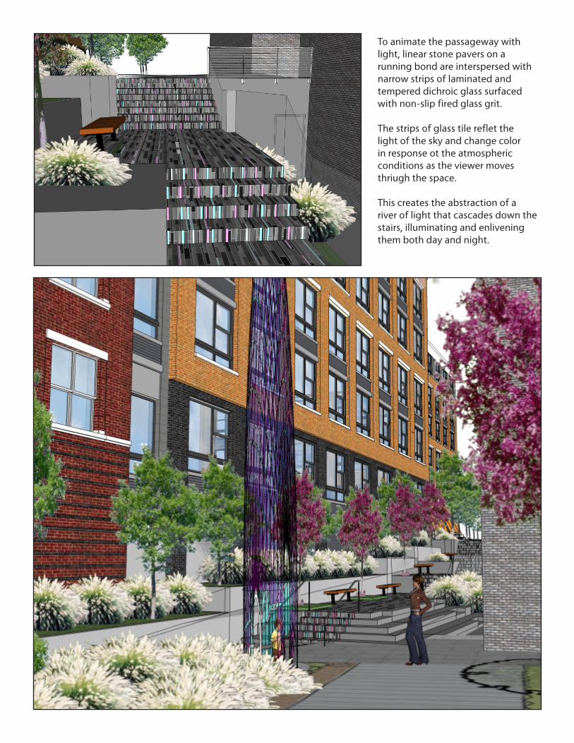
To animate the passageway with light, linear stone pavers on a running bond are interspersed with narrow strips of laminated and tempered dichroic glass surfaced with non-slip fired glass grit.
The strips of glass tile reflet the light of the sky and change color in response ot the atmospheric conditions as the viewer moves thriugh the space.
This creates the abstraction of a river of light that cascades down the stairs, illuminating and enlivening them both day and night.

All of the light that reflects in Wing Spire and the stairs comes from the sky overhead by day. At night the spire is illuminated from within and below, while the stairs and risers reflect light from above.
The artist hopes to build the base of the sculpture in a manner that will allow passersby to look up into the luminous thirty-foot tall form.