Embed Size (px)
Citation preview

1
Monuments at Risk?
Mapping threats to heritage assets on the Malvern Hills: The British Camp Hillfort Survey
June 2015
National Grid Reference SO 760 399
Dr Jodie Lewis and Cat Lodge,Institute of Science and the
Environment, University of Worcester

Monuments at Risk? Mapping threats to heritage assets on the Malvern Hills June 2015
2
Abstract
The aim of this project was to record and categorise the poential threats to British Camp
Hillfort, focusing specifically on damage caused by intrusive vegetation, rabbits and foot
and bicycle traffic. This was achieved through fieldwork and the use of Trimble GeoXT GPS
system. The results were mapped using ArcGIS 10.2.1.
The results showed that whilst significant parts of the hillfort are in good condition, there
are areas of concentrated damage and erosion across specific parts of the monument which
may threaten earthworks and subsurface archaeology. The accurate mapping of these areas
means there is a body of data that can be used as a baseline against which to evaluate the
condition of the hillfort in the future.

Monuments at Risk? Mapping threats to heritage assets on the Malvern Hills June 2015
3
Contents
Abstract 2
List of Figures and Abbreviations 4
1.0 Introduction 5
2.0 Understanding the Asset 5
2.1 Location and Access 6
2.2 Topography and Geology 7
2.3 Archaeology 8
2.5 Ownership/management responsibilities 10
3.0 Aims & Objectives
3.1 Aim 10
3.2 Objectives 10
4.0 Methodology 11
5.0 Results 12
6.0 Discussion 24
7.0 Conclusion 31
Bibliography 32
Appendix Vegetation types across study area 33

Monuments at Risk? Mapping threats to heritage assets on the Malvern Hills June 2015
4
List of Figures & Tables
Figure Page 1 Location Map 6 2 Map of site geology 7 3 Map of site soil parent material 7 4 View of Herefordshire Beacon/British Camp Hill Fort 8 5 The Shire Ditch 9 6 Proportion of threats by total area of hillfort 12 7 Summary of vegetation and erosion management issues in Herefordshire Council CMP 13 8 Areas of Human Erosion 14 9 Survey Results of Molehills Recorded 15
10 Survey Results of Rabbit Holes Recorded 16 11 Survey Results of Scattered Rabbit Damage 17 12 Survey Results of Intensive Rabbit Damage 18 13 Combined rabbit holes, scattered and intensive rabbit damage 19 14 Locations of Isolated Trees 20 15 Total Vegetation Cover Excluding Isolated Trees 21 16 Total Vegetation Cover Including Isolated Trees 22 17 Total Recorded Threats and Erosion 23 18 Visible erosion along footpath 24 19 Footpath along rampart looking towards British Camp 25 20 Damage to upper rampart through human erosion in the form of gulleys 25 21 Array of areas of rabbit damage on various parts of the monument 26 22 Evidence of mole activity along path 27 23 Isolated trees along eastern side of Herefordshire Beacon 28 24 Area of brambles on lower rampart on the west of the monument 29 25 Area of gorse being recorded by students in May 2014 30 26 Areas of bracken cover 33 27 Areas of brambles 34 28 Areas of gorse 35 29 Areas of Rosebay Willowherb 36 30 Tree Cover 37 31 Google Earth image of study area 38
Table Page 1 Range of Accuracy for GPS Data 11
Key Abbreviations
AONB Area of Outstanding Natural Beauty CMP Conservation Management Plan GPS Geographical Positioning System HER Historic Environment Record HSM Herefordshire Sites and Monuments MHC Malvern Hills Conservators SM Scheduled Monument SSSI Site of Special Scientific Interest

Monuments at Risk? Mapping threats to heritage assets on the Malvern Hills June 2015
5
1.0 Introduction
Herefordshire Beacon (British Camp) is an Iron Age hillfort found in the Malvern Hills and
is one of the most nationally important, complex and distinctive topographical sites of
this type in Britain. It is one of two that dominate the area, the other being Midsummer
Hill, Eastnor. Both are located on the ridge of the Malvern Hills. The site is protected as a
Scheduled Monument (SM) as well as being in an Area of Outstanding Natural Beauty
(AONB) and a part of the wider Site of Special Scientific Interest (SSSI) of the Malvern
Hills. Such designation facilitates the conservation of the site through plans and actions
by the relevant statutory (or other) bodies.
The hillfort is popular for recreation with both tourists and locals and in addition,
burrowing animals such as rabbits are prevalent. As a result, parts of the hillfort suffer
from extensive erosion from rabbits and foot/bike traffic and there are also issues
relating to intrusive vegetation. This research, which forms part of a larger project
Memorialisation and Commemoration on the Malvern Hills initiated in 2013 by Dr Jodie
Lewis, aims to record and map this erosion through field observation and the use of
differential GPS systems. This work follows the publication of a Conservation
Management Plan (CMP), prepared as part of a Higher Level Stewardship Agreement
under Natural England’s Environmental Stewardship Scheme in partnership with the
Malvern Hills Area of Outstanding Natural Beauty for Herefordshire Council, and it is
hoped that it can be used in conjunction to aid the future management of the site.
This project was funded by the University of Worcester Earn as You Learn Students as
Researchers scheme.

Monuments at Risk? Mapping threats to heritage assets on the Malvern Hills June 2015
6 Figure 1: Location of Herefordshire Beacon (British Camp)
(© Crown copyright supplied by Edina Digimap 2014)
2.0 Understanding the Asset
2.1 Location and Access
British Camp, comprising Herefordshire Beacon and Millennium Hill, forms part of the
main ridge of the Malvern Hills, a landscape which spans 12.5 kilometres bordering the
western edge of the Severn Valley (figure 1). The site straddles the county boundary
between Herefordshire and Worcestershire, however it mainly resides within the parish
of Colwall in Herefordshire.

Monuments at Risk? Mapping threats to heritage assets on the Malvern Hills June 2015
7
2.2 Topography and Geology
British Camp covers approximately 19.3 hectares and the altitude of the site ranges
from 265m to 338m OD. The highest summit is the citadel at 338m OD.
The bedrock, which is part of the Malverns Complex, is largely comprised of an igneous
intrusion of granitic rock; some of the oldest geology in the British Isles (Dorling 2013).
This is represented by the purple shading in figure 2 below.
The soil of the site is mainly freely draining acid loamy soil over rock which is found
across 2.6% of England (Soilscapes 2014).
Figure 3. Map of site geology (British Geological Survey 2014)
Figure 3. Map of site soil parent material (Soilscapes 2014)

Monuments at Risk? Mapping threats to heritage assets on the Malvern Hills June 2015
8
2.3 Archaeology
The study area consists of three main archaeological features: the Iron Age
hillfort, the medieval ringwork (the "Citadel"), and the Shire Ditch.
British Camp is one of five hillforts situated along the Malvern Hills, incorporating
Herefordshire Beacon and extending towards Millennium Hill (Bowden 2005).
Evidence is apparent for three defined periods of major construction; the first two
during the Iron Age with the creation of the hill fort, and the third known as the
‘Citadel’ from the medieval period.
Figure 4: View of Herefordshire Beacon/British Camp Hill Fort (Malvern Hills AONB 2015)
The Citadel (or Herefordshire Beacon Ringwork) dates to the medieval period and
consists of a ringwork and bailey, with possible signs of a stone gateway on the
bailey. The central enclosure is a ring motte, presumably of 12th century date
(Herefordshire Through Time 2010). The ringwork itself has an interior platform
surrounded by a rampart and is morphologically of medieval date (Bowden 2005),
and appears to range from the 11th century to the 14th century. The ringwork can be
seen as the uppermost earthwork in figure 4.
The Shire Ditch (Scheduled Ancient Monument 244) is a linear boundary that runs
along most of the principal ridge of the Malvern Hills (figure 5). Due to its
relationship with Midsummer Hill, it is thought by some that its origin may be
prehistoric, and Hooke’s work (1985; 1990), cited by Bowden (2005) suggests that it
was a significant feature in the landscape in the Anglo-Saxon period.

Monuments at Risk? Mapping threats to heritage assets on the Malvern Hills June 2015
9
Since the 10th century AD, the Shire Ditch has functioned as an estate boundary as
well as the diocesan boundary between Hereford and Worcester. The Shire Ditch’s
relationship with British Camp shows that here at least it post-dates the hillfort
(Bowden 2005; Herefordshire Through Time 2010).
Figure 5: The Shire Ditch (Malvern Hills Conservators 2010)
The statutory designations for the site are:
Scheduled Ancient Monument number: 113786
Worcestershire Sites and Monuments number: WSM00932
Herefordshire Sites and Monuments number: 932
Site of Special Scientific Interest (SSSI): The Malvern Hills
Area of Outstanding Natural Beauty: Malvern Hills
National Character Area (NCA) number 103: Malvern Hills

Monuments at Risk? Mapping threats to heritage assets on the Malvern Hills June 2015
10
2.4 Ownership/management responsibilities
The responsibility and ownership of Herefordshire Beacon lies with the Malvern Hills
Conservators (MHC). Other key partners or interest organisations of the MHC
include: the Malvern Hills AONB Partnership, English Heritage, Natural England,
Southern Hills Grazier and Herefordshire Archaeology.
The management of the site comes from a collaboration of plans and actions from all
of these statutory and non-statutory bodies.
3.0 Aim & Objectives
3.1 Aim
The aim of this project was to record and map the threats (e.g. rabbits, intrusive
vegetation, sledging, foot and bicycle traffic) to British Camp Iron Age Hillfort to sub-
metre accuracy in the hope of aiding and building upon the conservation
management plan of the hillfort prepared by Herefordshire Council. This project will
also seek to understand the wider implications of the erosion to Herefordshire
Beacon.
The rationale for undertaking this project was also to enable this data, collected at a
specific point in time, to be used as a baseline to evaluate the future condition
against. Indeed, Dorling (2013) proposed that monitoring should be ongoing.
3.2 Objectives
Categorise types of damage/erosion
Collect data in the field using differential GPS.
Download and collate results on ArcGIS 10.2.1.
Analyse and contextualise the results

Monuments at Risk? Mapping threats to heritage assets on the Malvern Hills June 2015
11
4.0 Methodology
The fieldwork for this project was undertaken in wet / foggy to moderate conditions
by four people between the 23rd and 28th May 2014.
The study area was defined by the outer ramparts of the British Camp hillfort, with a
buffer of 25 metres extending outwards: the area covers approximately 19.7
hectares. This buffer was implemented in the ArcGIS software onto the English
Heritage plan of the monument.
A pro-forma database schema of the types of erosion to be recorded was created and
the data collected using a Trimble GeoXT GPS to sub-metre accuracy (Table 1). The
terms used, which were identified from the CMP, included rabbit areas (both scattered
and concentrated), rabbit holes, vegetation areas, erosion areas or lines, tree points
and generic points or areas of other data that was felt to be significant.
Table 1. Range of accuracy for GPS data
Range Percentage
0-15cm -
15-30cm -
30-50cm 21.2%
0.5-1m 76.4%
1-2m 2.4%
2-5m 0.1%
>5m -
The data was collected systematically, working from the lower ramparts upwards and
starting from the northern plateau and heading south towards Millennium Hill
(figure 1). Where possible, the erosion was mapped out as polygons, to denote
areas, and points, for isolated features. Lines were used to mark the top and/or
bottom of erosion areas when mapping the entire perimeter of the area became
impractical, for example when vegetation was too thick or ramparts too steep to
allow access. Aerial imagery was then used alongside this to mark the full extent of
the erosion during mapping. Using ArcGIS 10.2.1, the data was overlaid onto base
mapping, including Bowden’s metrical survey (2005) and Google Earth imagery, to
illustrate the extent of the damage.

Monuments at Risk? Mapping threats to heritage assets on the Malvern Hills June 2015
12
25.03%
1.73%
7.99%
0.28%
64.97%Vegetation
Intensive Rabbit Damage
Scattered Rabbit Damage
Human Erosion
Satisfactory Condition
5.0 Results
Figure 6 below represents the proportion of threats/damage to British Camp hillfort
recorded and mapped during this study.
Figure 6: Proportion of threats by total area of hillfort
Almost 65% of the monument is deemed to be in satisfactory condition. Vegetation
accounts for the largest proportion of threats, covering 25% of the monument,
predominantly on the lower ramparts. Significant erosion caused by rabbit activity
affects almost 10% of the study area. Anthropogenic damage is minimal in
comparison to these two categories but many of the threats overlap and are
exacerbated by each other.
The following section provides detailed maps of the GPS survey results, as defined in
the methodology. Each threat is mapped individually, as well as composite figures for
rabbit damage and vegetation. A final composite map showing all areas of damage
and threat to the monument is also included. Figure 31 in the appendix is a Google
Earth image of the study area which also clearly shows the different vegetation and
erosion.

Monuments at Risk? Mapping threats to heritage assets on the Malvern Hills June 2015
13
Figure 7 is taken from Dorling’s 2013 report and is a summary of vegetation and
erosion management issues. This will be used for comparison with the final composite
map produced for this study.
Figure 7: Summary of vegetation and erosion management issues in Herefordshire Council CMP (Dorling 2013, 53)

Monuments at Risk? Mapping threats to heritage assets on the Malvern Hills June 2015
14
Figure 8: Areas of Human Erosion. Metric survey copyright Bowden 2005.
Monuments at Risk? Mapping threats to heritage assets on the Malvern Hills June 2015
15
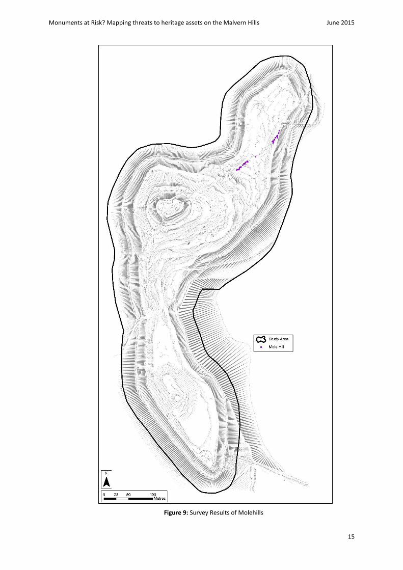
Figure 9: Survey Results of Molehills

Monuments at Risk? Mapping threats to heritage assets on the Malvern Hills June 2015
16
Figure 10: Survey Results of Rabbit Holes

Monuments at Risk? Mapping threats to heritage assets on the Malvern Hills June 2015
17
Figure 11: Survey Results of Scattered Rabbit Damage

Monuments at Risk? Mapping threats to heritage assets on the Malvern Hills June 2015
18
-
Figure 12: Survey Results of Intensive Rabbit Damage

Monuments at Risk? Mapping threats to heritage assets on the Malvern Hills June 2015
19
Figure 13: Combined rabbit holes, scattered and intensive rabbit damage

Monuments at Risk? Mapping threats to heritage assets on the Malvern Hills June 2015
20
Figure 14: Locations of Isolated Trees

Monuments at Risk? Mapping threats to heritage assets on the Malvern Hills June 2015
21
Figure 15: Total Vegetation Cover excluding Isolated Trees

Monuments at Risk? Mapping threats to heritage assets on the Malvern Hills June 2015
22
Figure 16: Total vegetation cover including isolated trees

Monuments at Risk? Mapping threats to heritage assets on the Malvern Hills June 2015
23
Figure 17: Total recorded threats and erosion

Monuments at Risk? Mapping threats to heritage assets on the Malvern Hills June 2015
24
6.0 Discussion
The maps in the results section show the data recorded in the GPS survey, as outlined
in the methodology. The main categories recorded are:
Human Erosion
Rabbit Damage (rabbit holes, scattered damage & intrusive damage)
Mole Hills
Vegetation (including isolated trees)
Human Erosion
The Malvern Hills are an area popular for recreation and the improvement of paths
to the summit of Herefordshire Beacon has made the site more accessible. Erosion
as a result of foot and bicycle traffic (as well as other recreational activities such as
sledging in the winter) is apparent in all parts of the study area.
The results of the GPS survey clearly identify the main areas of damage as a result of
human erosion (figure 8) as concentrated around the lower ramparts of the
monument.
Figure 18: Visible erosion along footpath
Humans cause wear to the surface of the ground, but do not necessarily cause
significant damage to the archaeological integrity of the monument (Rimmington
2004). The entrenching of paths and routes through continued use, however, does

Monuments at Risk? Mapping threats to heritage assets on the Malvern Hills June 2015
25
lead to significant damage and erosion of archaeological deposits as well as alterations
to the profiles and setting of the earthworks (figures 18-20).
Figure 19: Footpath along rampart looking towards British Camp
Figure 20: Damage to upper rampart through human erosion in the form of gulleys
Significant erosion caused by human activity has also been recorded along the path
between Millennium Hill and Herefordshire Beacon, and at the south-eastern end
and the summit of Millennium Hill (figure 8).

Monuments at Risk? Mapping threats to heritage assets on the Malvern Hills June 2015
26
Rabbit Damage
Rabbit burrows are concentrated on the eastern side of the monument (figure 10),
and scattered rabbit damage is also most evident on the eastern side (figure 11).
Intensive rabbit damage, such as shown in the top right and bottom left photographs
in figure 21, is most obvious on the summit and eastern side of Herefordshire Beacon
on the slopes of the ramparts (figure 12). Dorling highlighted one main area of rabbit
damage on the south-eastern side of Herefordshire Beacon and also indicated that
there were other less significant areas of damage across the rest of the monument. It
would appear when comparing figures 7 and 13 that more damage has been caused
as a result of rabbit activity, especially to the north-east of the monument.
Scattered rabbit damage is defined as individual burrows close, but not necessarily
immediately adjacent to others, whereas intensive rabbit damage was where large
areas of erosion were apparent due to a concentrated rabbit population.
Rabbit damage is worsened by foot or bike traffic which exacerbates erosion -
areas such as the Citadel clearly show this (figure 17).
Figure 21: Array of areas of rabbit damage on various parts of the monument
Efforts to control the rabbit population took place prior to 1998 through the
utilisation of ferrets and blocking of rabbit holes (Alma 1998), and again in 2013/14
(Dorling 2013).

Monuments at Risk? Mapping threats to heritage assets on the Malvern Hills June 2015
27
Mole hills
Figure 9 illustrates the areas of molehills recorded, and it is apparent that the majority
of resultant damage from this category is to the north east of the ringwork of British
Camp. The molehills appear to run parallel to the main footpath from the car park
(figure 22).
Figure 22: Evidence of mole activity along path
The burrowing animals on British Camp have the potential to destabilise the
earthworks leading to exposure of the soil and further degradation from influences
such as the wind and the rain (Rimmington 2004). Evidence from other monuments
would suggest the earthworks on British Camp, which have a slope greater than 20%,
are particularly susceptible to this type of erosion.
Erosion from burrowing animals may thus result in the loss of archaeological
evidence in the form of both upstanding and buried remain. Rimmington (ibid) also
details how the tunnelling activities of these animals can destroy stratigraphy and
result in the redistribution of artefacts and the ultimate loss of information.

Monuments at Risk? Mapping threats to heritage assets on the Malvern Hills June 2015
28
Vegetation
There is abundant vegetation across the whole of the monument, ranging from trees
to bracken and gorse. Figure 16 illustrates all vegetation cover, including the isolated
trees recorded during the survey, and the appendix includes maps of the different
types of vegetation recorded during the GPS survey which comprises bracken, gorse,
brambles, Rosebay Willowherb and trees.
There are small pockets of vegetation around the upper ramparts of Herefordshire
Beacon and along Millennium Hill, but most vegetation is located around the
periphery of the monument on the lower ramparts, specifically along the western
edge and north-east. It is apparent that the vegetation is beginning to move upwards
A number of isolated trees were recorded within the study area, and these are mostly
located on the lower reaches of the eastern side of the monument (figures 14 and 23).
Figure 30 in the appendix highlights the areas of denser tree cover, which in
comparison is on the western side and extends down over the slopes.
Figure 23: Isolated trees along eastern side of Herefordshire Beacon

Monuments at Risk? Mapping threats to heritage assets on the Malvern Hills June 2015
29
Bracken is concentrated on the northern side of the monument, along the lower
ramparts (figure 26). Certain species of vegetation, in particular bracken, are a source
of cover for rabbits (Dorling 2013). The control of bracken may need to be
undertaken to prevent the risk of further damage in the areas where vegetation and
rabbit activity are present. Bracken itself can be damaging to the long-term
preservation of archaeological sites and may have a detrimental effect on the
survival of archaeological remains (Rimmington 2004).
Bramble and gorse are two other forms of vegetation that are prevalent across the
monument. Bramble is more concentrated around the western side along the lower
ramparts, with small pockets on the eastern side (figures 24 & 27). Gorse is evident in
almost exactly the same locations as bramble, but extends further up the slopes, and
is more abundant on Millennium Hill than the bramble (figures 25 & 28).
Figure 24: Area of brambles on lower rampart on the west of the monument
Both bramble and gorse have the potential to affect the visibility of the
monument, encourage rabbit activity and damage archaeology through root
disturbance (Rimmington 2004).

Monuments at Risk? Mapping threats to heritage assets on the Malvern Hills June 2015
30
Figure 25: Area of gorse being recorded by students in May 2014
Rosebay Willowherb appears to be concentrated along the north-eastern side of the
study area, with a small area to the north-west (figure 29). This type of plant is
invasive, and like the other forms of vegetation in this report may cause damage to
the integrity of the archaeological deposits within this area.
A survey carried out in 2013-14 by the Malvern Hills AONB showed that it was believed
100% of the scheduled monuments across the Malvern Hills were in ‘satisfactory
condition’ (2014), and had improved from the 2008 trend of 63%. Based on the
results of this report it is evident that the headline indicator of the AONB report may
need revisiting, as only 65% of the monument was deemed to be in satisfactory (that
is, "unthreatened") condition (figure 6).
The site has seen the reintroduction of grazing animals to combat scrub and this,
along with hand cutting of vegetation, will need to be monitored to measure success
(Dorling 2013).

Monuments at Risk? Mapping threats to heritage assets on the Malvern Hills June 2015
31
7.0 Conclusion
This project accurately mapped and quantified the nature and scale of certain threats to
British Camp Iron Age hillfort and provides a base for future assessment and monitoring.
The results have expanded upon an initial assessment by Herefordshire Council and can
be used to help inform future management and conservation decisions.
Further considerations for study might include the detailed mapping of the entrenchment
of paths or routes caused by recreational pedestrian and cycle traffic, the spread of
rosebay willowherb onto cleared areas, and assessment of the maturity of vegetation. The
research undertaken for this study has also noted the emerging activity of moles which
may become a future threat and may benefit from monitoring.

Monuments at Risk? Mapping threats to heritage assets on the Malvern Hills June 2015
32
Bibliography
Alma, P.J. (1998) The Ecology and Nature Conservation Value of the Land under the Control
of the Malvern Hills Conservators. Unpublished report derived from the Malvern Hills Conservators Management Plan Review.
Bowden, M. (2005) The Malvern Hills: An ancient landscape. London, English Heritage.
British Geological Survey (2014) Geology of Britain Viewer. [Online] Available From: http://www.bgs.ac.uk/discoveringGeology/geologyOfBritain/viewer.html [Accessed 28th May 2014]
Dorling, P. (14th October 2013) A Conservation Management Plan for Herefordshire Beacon (‘British Camp’), Colwall, Herefordshire. Herefordshire Council.
Herefordshire Through Time (2010) Herefordshire Beacon Camp, ringwork. [Online] Available from: http://htt.herefordshire.gov.uk/smrSearch/Monuments/Monument_Item.aspx?ID=7155 [Accessed: 14th June 2015]
Malvern Hills AONB (2015) Herefordshire Beacon. [Online] Available from: http://www.malvernhillsaonb.org.uk/about-the-aonb/image-gallery/ [Accessed: 14th June 2015]
Malvern Hills Conservators (2010) The Shire Ditch. [Online] Available from: http://www.malvernhills.org.uk/visiting/archaeology_of_the_hills.aspx [Accessed: 14th June 2015]
Malvern Hills Area of Outstanding Natural Beauty (2013) Management Plan 2014-2019.
Worcestershire, Malvern Hills AONB Partnership.
Natural England (2012) National Character Area profile: Malvern Hills 103. [Online] Available From: http://publications.naturalengland.org.uk/publication/3039205 [Accessed 28th May 2014]
Rimmington, J. N. (2004) Managing Earthwork Monuments.
Soilscapes (2014) Soilscapes map. [Online] Available From: http://www.landis.org.uk/soilscapes [Accessed 28th May 2014]

Monuments at Risk? Mapping threats to heritage assets on the Malvern Hills June 2015
33
Appendix: Vegetation types across study area
Figure 26: Areas of bracken cover

Monuments at Risk? Mapping threats to heritage assets on the Malvern Hills June 2015
34
Figure 27: Areas of brambles

Monuments at Risk? Mapping threats to heritage assets on the Malvern Hills June 2015
35
Figure 28: Areas of gorse

Monuments at Risk? Mapping threats to heritage assets on the Malvern Hills June 2015
36
Figure 29: Areas of Rosebay Willowherb

Monuments at Risk? Mapping threats to heritage assets on the Malvern Hills June 2015
37
Figure 30: Tree cover

Monuments at Risk? Mapping threats to heritage assets on the Malvern Hills June 2015
38
-
Figure 31: Google Earth image of study area


![Act V, Scene i The British camp, near DoverAct V, Scene i The British camp, near Dover Enter, with drum and colors, EDMUND, REGAN, gentlemen, and soldiers EDMUND [To a gentleman] Know](https://img.pdfslide.net/doc/110x75/5ed39b2ea25ce63a2754a976/act-v-scene-i-the-british-camp-near-dover-act-v-scene-i-the-british-camp-near.jpg)