Embed Size (px)
Citation preview
www.elsevier.com/locate/tecto
Tectonophysics 371 (2003) 223–241
Morphological and structural relations in the Galilee
extensional domain, northern Israel
A. Matmona,b,*, S. Wdowinskic, J.K. Hallb
aDepartment of Geology, Hebrew University, Jerusalem 91904, IsraelbGeological Survey of Israel, 30 Malkhe Yisrael Street, Jerusalem 95501, Israel
cDepartment of Geophysics and Planetary Sciences, Tel Aviv University, Tel Aviv, 69978, Israel
Received 6 December 2001; accepted 11 June 2003
Abstract
The Lower Galilee and the Yizre’el Valley, northern Israel, are an extensional domain that has been developing since the
Miocene, prior and contemporaneously to the development of the Dead Sea Fault (DSF). It is a fan-shaped region bounded in
the east by the N–S trending main trace of the DSF, in the north by the Bet-Kerem Fault system, and in the south by the NW–
SE trending Carmel Fault. The study area is characterized by high relief topography that follows fault-bounded blocks and
flexures at a wavelength of tens of km. A synthesis of the morphologic–structural relations across the entire Galilee region
suggests the following characteristics: (1) Blocks within the Lower Galilee tilt toward both the southern and northern
boundaries, forming two asymmetrical half-graben structures, opposite facing, and oblique to one another. (2) The Lower
Galilee’s neighboring blocks, which are the Upper Galilee in the north and the Carmel block in the southwest, are
topographically and structurally uplifted and tilted away from the Lower Galilee. (3) The southern half-graben, along the
Carmel Fault, is topographically and structurally lower than the northern one. Combining structural and geological data with
topographic analysis enables us to distinguish several stages of structural and morphological development in the region. Using a
semi-quantitative evolutionary model, we explain the morpho-structural evolution of the region. Our results indicate that the
Galilee developed as a set of two isostatically supported opposite facing half-grabens under varying stress fields. The southern
one had started developing as early as the early Miocene prior to the formation of the DSF. The northern and younger one has
been developing since the middle Pliocene as part of the extension process in the Galilee. Elevation differences between the two
half-grabens and their bounding blocks are explained by differences in isostatic subsidence due to sedimentary loading and
uplift of the northern half-graben due to differential influences of the regional folding.
D 2003 Elsevier B.V. All rights reserved.
Keywords: Tilted blocks; Normal faults; Galilee; Rift margins; Extension
0040-1951/03/$ - see front matter D 2003 Elsevier B.V. All rights reserve
doi:10.1016/S0040-1951(03)00237-3
* Corresponding author. Current address: U.S. Geological
Survey, 345 Middlefield Road MS #977, Menlo Park, CA, 94025,
USA.
E-mail address: [email protected] (A. Matmon).
1. Introduction
The Galilee region is located in northern Israel
between the Mediterranean and the Dead Sea Fault
(DSF), which is the boundary separating between the
Sinai and Arabian plates (Garfunkel, 1970, 1981; Fig.
1). The present structure of the Galilee has been
d.
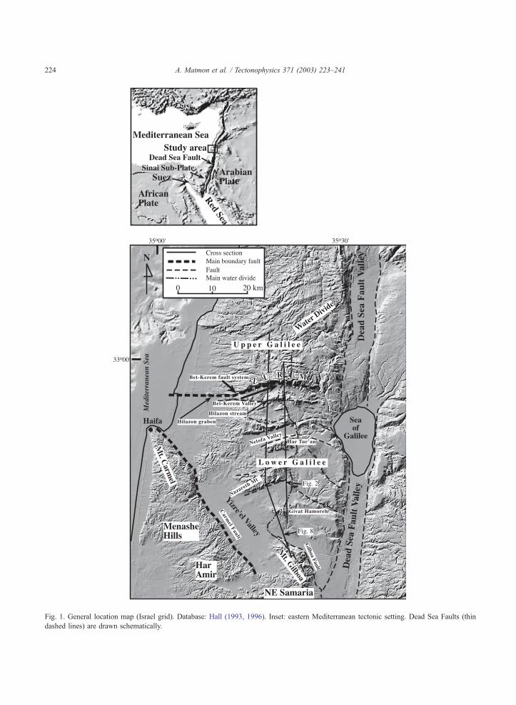
Fig. 1. General location map (Israel grid). Database: Hall (1993, 1996). Inset: eastern Mediterranean tectonic setting. Dead Sea Faults (thin
dashed lines) are drawn schematically.
A. Matmon et al. / Tectonophysics 371 (2003) 223–241224
A. Matmon et al. / Tectonophysics 371 (2003) 223–241 225
developing since the Miocene, prior and contempora-
neously to the development of the DSF (Freund,
1970). Understanding the development and evolution
of the Galilee provides important observations regard-
ing the tectonic and structural conditions that existed in
the region prior, during, and after the formation of the
DSF. Furthermore, the Galilee is the only extensional
domain that extends well beyond the Dead Sea Fault’s
narrow rift margins. Hence, studying the structural and
morphological relations between the Galilee and the
Dead Sea Fault provide better understanding of the
coupling between transcurrent movements and adja-
cent diffuse extensional deformation. Such extensional
domains are also observed along other continental
transform faults, e.g., the Gadiz and Buyuk Menderes
grabens in western Turkey south of the North Anato-
lian Fault.
The Galilee is divided into two major domains, the
Lower and Upper Galilee (Fig. 1). The study area
(which includes the Lower Galilee and the Yizre’el
Valley) consists of a series of E–W trending ridges and
tilted blocks bounded by normal faults (Freund, 1970)
and separated by elongated valleys (Figs. 1 and 2). The
study area is bounded in the north by the Upper Galilee
block that rises above the Zurim Escarpment and in the
south by the Carmel block (Fig. 1). Because the
northern and southern boundaries are oblique to each
other (Fig. 1), the extended region has a fan shape. It is
about 50 km wide at its eastern side (close to the DSF)
and narrows towards the west to about 20 km along the
coastal plain.
The topographic–structural relations in the Galilee
have been studied for almost four decades. The rela-
tions between Miocene and Pliocene structures and
topography were studied by analyzing sedimentary
sequences (Kafri and Ecker, 1964; Issar and Kafri,
1972; Shaliv, 1991). Fruend (1970), Ron et al. (1984),
and Ron and Eyal (1985) studied the Neogene tectonic
activity and stress fields in the Galilee and pointed out
the correlation between topography and young struc-
tural elements. Freund (1965) related the extension in
the Galilee to the left lateral displacement and geom-
etry of the DSF and calculated that such extension
amounted to 5–7% (Freund, 1970). While Freund’s
suggestion that left lateral movement along the DSF
explains the extension and some other morphologic
and structural features in the Galilee, it does not
provide answers to other observation, mainly the
structural and topographic characteristics of the
bounding blocks of the Lower Galilee.
In this study, we systematically explore and char-
acterize the relations between topography and struc-
ture in the Lower Galilee and Yizre’el Valley and their
bounding blocks. Our study expands beyond the
extensional Lower Galilee and Yizre’el Valley, and
includes the neighboring Upper Galilee and Carmel
blocks. The southwestern boundary of the extensional
domain is well defined by a single fault, the Carmel
Fault. However, the southeastern boundary is not as
well defined. It diffuses into several parallel faults,
which form the northeastern Samaria and the Gilboa
blocks. We exclude these areas from our analysis for
several reasons: the complexity of the boundary fault,
the influence the Dead Sea Fault Valley marginal
normal faults on the eastern blocks, and the lack of
structural data from the NE Samaria.
We first provide the geological background of the
region and describe its main structural and morpho-
logical elements. Then, we analyze the Galilee’s mor-
pho– tectonic relations by constructing arc-shaped
sections across the fan-shape extensional domain and
its neighboring uplifted blocks. Our analysis results
combined with previous observations suggest that the
morphologic and tectonic history of the Lower Galilee,
the Yizre’el Valley, and their adjacent bounding blocks
are best described by a set of two opposite facing half-
grabens, a southern one that started developing as early
as the early Miocene and a northern and younger one
that has been developing since the middle Pliocene.
The observed relations between the structure and
topography are explained by using a semi-quantitative
evolutionary model.
2. Geologic background
The structure and recent topography did not evolve
contemporaneously throughout the Galilee. Its various
parts experienced different geological histories. A pre-
Eocene structure, the Syrian Arc fold belt (Krenkel,
1924; Picard, 1943), which in the Galilee consists of a
series of N–S oriented anticlines and synclines, started
developing in the Senonian as a response to closing of
the Tethys Ocean (Flexer et al., 1970). The Syrian Arc
fold belt does not influence the present morphology of
the Galilee. Here we provide a short review of the
A. Matmon et al. / Tectonophysics 371 (2003) 223–241226
geological history of the region from the late Eocene to
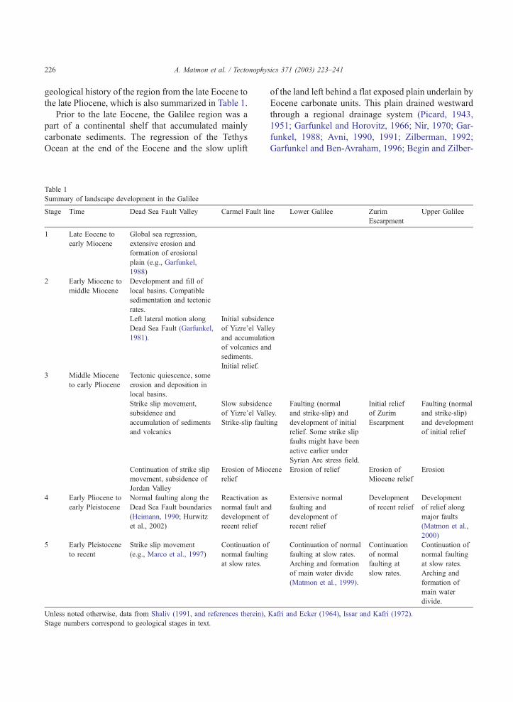
the late Pliocene, which is also summarized in Table 1.
Prior to the late Eocene, the Galilee region was a
part of a continental shelf that accumulated mainly
carbonate sediments. The regression of the Tethys
Ocean at the end of the Eocene and the slow uplift
Table 1
Summary of landscape development in the Galilee
Stage Time Dead Sea Fault Valley Carmel Fault li
1 Late Eocene to
early Miocene
Global sea regression,
extensive erosion and
formation of erosional
plain (e.g., Garfunkel,
1988)
2 Early Miocene to
middle Miocene
Development and fill of
local basins. Compatible
sedimentation and tectonic
rates.
Left lateral motion along
Dead Sea Fault (Garfunkel,
1981).
Initial subsiden
of Yizre’el Vall
and accumulati
of volcanics an
sediments.
Initial relief.
3 Middle Miocene
to early Pliocene
Tectonic quiescence, some
erosion and deposition in
local basins.
Strike slip movement,
subsidence and
accumulation of sediments
and volcanics
Slow subsidenc
of Yizre’el Vall
Strike-slip fault
Continuation of strike slip
movement, subsidence of
Jordan Valley
Erosion of Mio
relief
4 Early Pliocene to
early Pleistocene
Normal faulting along the
Dead Sea Fault boundaries
(Heimann, 1990; Hurwitz
et al., 2002)
Reactivation as
normal fault an
development of
recent relief
5 Early Pleistocene
to recent
Strike slip movement
(e.g., Marco et al., 1997)
Continuation of
normal faulting
at slow rates.
Unless noted otherwise, data from Shaliv (1991, and references therein),
Stage numbers correspond to geological stages in text.
of the land left behind a flat exposed plain underlain by
Eocene carbonate units. This plain drained westward
through a regional drainage system (Picard, 1943,
1951; Garfunkel and Horovitz, 1966; Nir, 1970; Gar-
funkel, 1988; Avni, 1990, 1991; Zilberman, 1992;
Garfunkel and Ben-Avraham, 1996; Begin and Zilber-
ne Lower Galilee Zurim
Escarpment
Upper Galilee
ce
ey
on
d
e
ey.
ing
Faulting (normal
and strike-slip) and
development of initial
relief. Some strike slip
faults might have been
active earlier under
Syrian Arc stress field.
Initial relief
of Zurim
Escarpment
Faulting (normal
and strike-slip)
and development
of initial relief
cene Erosion of relief Erosion of
Miocene relief
Erosion
d
Extensive normal
faulting and
development of
recent relief
Development
of recent relief
Development
of relief along
major faults
(Matmon et al.,
2000)
Continuation of normal
faulting at slow rates.
Arching and formation
of main water divide
(Matmon et al., 1999).
Continuation
of normal
faulting at
slow rates.
Continuation of
normal faulting
at slow rates.
Arching and
formation of
main water
divide.
Kafri and Ecker (1964), Issar and Kafri (1972).
A. Matmon et al. / Tectonophysics 371 (2003) 223–241 227
man, 1997). By early Miocene, a regional erosional
plain dominated the topography of the area (Picard,
1943; Garfunkel, 1970, 1978) (Table 1, stage 1).
Miocene to recent tectonic movements have de-
formed the Oligocene erosional plain. The earliest
stages of extension in the Galilee took place in its
southern part along the Carmel Fault and the Yizre’el
Valley. The Yizre’el Valley is the largest and deepest
among the series of Lower Galilee basins and consists
of a thick Neogene sedimentary and volcanic se-
quence (e.g., Schulman, 1959, 1962; Shaliv, 1991).
During the Miocene, initial relief along the Carmel
Fault was formed (Table 1, stage 2; Karcz, 1959;
Achmon, 1986; Shaliv, 1991; Kashai and Picard,
1958). From the early Miocene to the early Pliocene,
lateral displacements took place along NW and NE
trending faults through the entire Galilee. However,
the topographic expression of most of this activity was
eroded (Matmon et al., 2000). The Carmel Fault was
also activated as a strike-slip fault during the later part
of this period (Table 1, stage 3; Ron et al., 1984).
Starting in the middle to late Pliocene, widespread
volcanism occurred mainly in the eastern Lower
Galilee (Shaliv, 1991). Normal faulting that formed
most of the structures controlling the recent morphol-
ogy of the Lower Galilee followed this volcanic stage.
Older faults, such as the Carmel Fault, were reacti-
vated to form their present morphology (Table 1, stage
4). The development of a broad structural arch formed
the mountainous backbone of Israel between the
Mediterranean and the DSF and continued through
the Pleistocene (Table 1, stage 5; Matmon et al.,
1999). The southward tilted sediments within the fill
of the Yizre’el Valley which thicken towards the
Carmel Fault, suggest continuous motion along the
fault during the Neogene and the quaternary (Kafri
and Ecker, 1964). A similar situation exists in the
down faulted block (the Hilazon graben) along the
western end of the Bet-Kerem Fault system. However,
the Hilazon graben contains only Quaternary sedi-
ments, indicating that the graben started subsiding
later than the Yizre’el Valley.
The N–S extensional deformation in the Galilee
has continued through the Quaternary (Table 1, stage
5). Displaced Pleistocene basalts indicate normal
displacement along some faults in the eastern Upper
Galilee (Mor et al., 1987). Fresh fault scarps are
exposed in several locations at the foot of uplifted
blocks in the Galilee and suggest major pulses of
normal displacement during the Holocene (Gran-
Mitchel et al., 2001). Hanging and truncated valleys
along some Galilee escarpments (Nir, 1970) also
suggested quaternary uplifting.
3. Structure and morphology
3.1. Structure
Two N–S trending structural systems affect the
morphology of the Galilee. The first is the Dead Sea
Fault that bounds the Galilee in the east; it consists of
left-lateral faults, separating the Arabian plate from the
Sinai sub-plate (Garfunkel, 1970; Fig. 1) and a series
of normal faults, which form escarpments bounding a
narrow rift valley. The activity along the rift’s faults
has been continuous since the Miocene to the present
(Quennell, 1959; Garfunkel, 1981, 1988; Heimann,
1990; Belitzki, 1997; Marco et al., 1997; Ellenblum et
al., 1998). The second N–S trending structural system
is a broad arch, 40–60 km wide, bounded between the
Mediterranean and the DSF. In the Galilee, the ampli-
tude of the arch, which took place during the Pleisto-
cene, is 200–300 m (Matmon et al., 1999). A number
of researchers, working in different areas along the
western margins of the DSF, concluded that the devel-
opment of the broad structural arch is related to that of
the DSF (Picard, 1943; Bentor and Vroman, 1951,
1961; Ball and Ball, 1953; Salamon, 1987; ten Brink et
al., 1990; Wdowinski and Zilberman, 1996, 1997;
Matmon et al., 1999).
The Carmel Fault, which is the southern boundary
of the Lower Galilee, was formed in the early Miocene
(Shaliv, 1991; Kashai and Picard, 1958) and has been
active ever since (Hofstetter et al., 1996; Salamon et al.,
1996). The western part if the Carmel Fault is defined
by a single fault. To the east, the Carmel Fault splays
into a series of E–W trending normal faults which
extend to the Dead Sea Fault valley and form the
extensional domain of northeast Samaria which is
bounded between the Gilboa and Fari’a Faults. Some
studies suggest that a weak zone existed along the
Carmel area since the late Paleozoic, although it did not
correspond directly with the present location of the
Carmel Fault (e.g., Garfunkel and Derin, 1984; Gar-
funkel and Almagor, 1985; Achmon, 1986; Dvorkin
A. Matmon et al. / Tectonophy228
and Kohn, 1989; Ben-Gai and Ben-Avraham, 1995;
Achmon and Ben-Avraham, 1997). The activity along
the Carmel Fault predated the activity of the DSF and
the adjacent Yizre’el Valley was formed as one in a
series of basins associated with the opening of the Red
Sea (Shaliv, 1991). The Carmel Fault truncates the
preexisting syncline (Menashe Hills) and anticline (Mt.
Carmel and Har Amir) structure of the Syrian Arc Fold
Belt (Picard and Golani, 1965). The topographic ex-
pression of the Carmel Fault is dominant where the
fault crosses the anticlines and poor where it crosses the
syncline. Geologic and topographic considerations as
well as recent seismic activity imply both normal and
lateral displacements along the Carmel Fault (Hofstet-
ter et al., 1996; Salamon et al., 1996).
Two major fault systems are identified within the
Galilee: strike-slip faults oriented NW–SE and NE–
SW (Freund, 1970; Ron et al., 1984; Ron and Eyal,
1985) and E–W oriented normal faults forming most
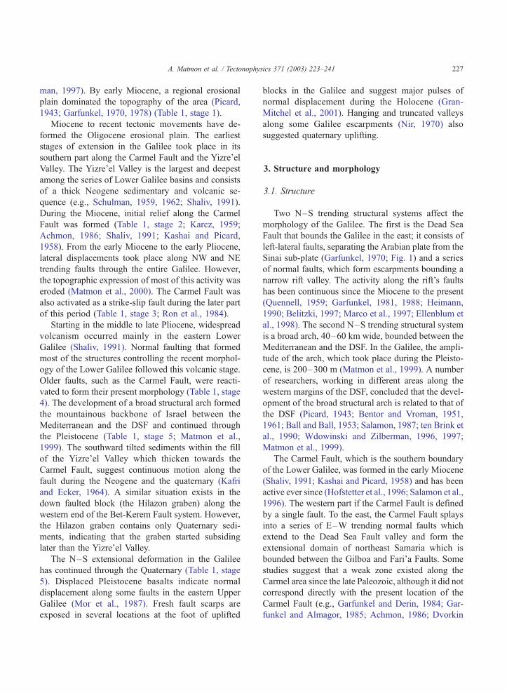
of the Galilee’s morphology. The shallow structure of
the Lower Galilee and its morphology are dominated
by E–W oriented tilted blocks, half-grabens, grabens
and horsts (Fig. 2; Schulman, 1962; Kafri and Ecker,
1964; Issar and Kafri, 1972; Mero, 1983; Sivan,
1996; Sivan et al., 1999). E–W normal faults are
less dominant in the Upper Galilee and control the
morphology only at the eastern and western edges of
the area. The Upper Galilee is intensively deformed
by the NW–SE and NE–SW strike-slip fault sys-
tems, although these do not contribute to its recent
morphology.
Fig. 2. The shallow structure of the Galilee (after Freund, 1970). The northe
and the southern part of blocks tilted to the south. The central part is dom
3.2. Morphology
The unique morphology of the Galilee is best
observed by tracing the water-divide between the
Mediterranean and the rift valley of the DSF. The
drainage system in Israel is composed of eastern and
western basins, which are drained to the rift valley and
the Mediterranean, respectively (Fig. 3). The main
water divide between these two base levels is located
along the mountainous backbone of Israel which is
oriented N–S and is parallel to sub-parallel to the DSF.
The mountainous backbone was formed as a result of
the development of the broad structural arch between
the DSF and the Mediterranean since the Pliocene. The
typical flat and low relief surface of the mountainous
backbone is generally composed of Mesozoic carbon-
ate rocks of the Judea Group and might reflect the
uplifted Oligocene to early Miocene erosional plain
(Garfunkel, 1988). The summits of the major moun-
tainous regions (the Negev, Judea, Samaria, and Upper
Galilee) are uplifted to a similar elevation of 900–
1000 m above sea level (Fig. 3).
The uniform topography of the mountainous back-
bone along the western margins of the DSF is truncat-
ed in the domain that includes the Lower Galilee and
northeastern Samaria. In this region, the mountainous
backbone was subjected to N–S extension that formed
the series of elongated ridges and valleys perpendicu-
lar to the axis of the main water divide. The summits of
the Lower Galilee are 400–500 m lower compared to
the other mountain ridges in Israel (Fig. 3). However,
sics 371 (2003) 223–241
rn part of the Lower Galilee is composed of blocks tilted to the north
inated by horsts.
Fig. 3. (A) Map showing the main water-divide that separates the western margins of the Dead Sea Fault into the two principle watersheds: the
Dead Sea Fault Valley and the Mediterranean. The water divide is parallel to subparallel to the Dead Sea Fault Valley and is located on the
central mountainous backbone of Israel. Dead Sea faults are drawn schematically. (B) Topographic profile along the main water-divide. The
altitude of the summits of most of the mountain ranges along the water-divide is 900–1000 m above sea level. The Lower Galilee is the lowest
mountainous region with its summits rising up to an altitude of 500–600 m above sea level. The lowest points along the water divide are also
located in the Lower Galilee.
A. Matmon et al. / Tectonophysics 371 (2003) 223–241 229
The stratigraphic units exposed on top of the uplifted
structures in the Lower Galilee are identical to those
exposed in other mountainous structures in Israel.
Therefore, it is reasonable to assume that the area
was not structurally low before the Oligocene–Mio-
cene denudation and it probably experienced the same
level of denudation as the other mountainous struc-
tures during that time. The lowest points along Israel’s
main water divide are located in the Lower Galilee, in
which the lowest one is in the Yizre’el Valley at an
A. Matmon et al. / Tectonophysics 371 (2003) 223–241230
elevation of 70 m above sea level (Fig. 3). The greatest
structural relief (relief formed by faulting as opposed
to relief formed by surface processes), up to 700 m, is
found in the Lower Galilee, where changes between
low and high regions are most abundant.
4. Morpho-structural analysis
The Lower Galilee and the Yizre’el Valley are a fan-
shaped extensional domain, bounded by two fault
systems, the Carmel Fault and Bet-Kerem Fault sys-
tem, which are oblique to one another. In order to
understand the regional scale structural and morpho-
logical relations between the extending region and its
neighboring blocks, we use arc-shaped geological
cross-sections, which are drawn normal to both major
fault systems. The arc-shaped sections are also parallel
to the regional average dip of the NW-tilting Upper
Galilee and the WSW-tilting Carmel block (Fig. 4).
Thus, unlike in previous studies (e.g., Kafri and Ecker,
1964; Freund, 1970; May, 1987), which drew struc-
tural sections in one direction across one of the
structural elements, our cross-sections display the
entire structure of the Lower Galilee, the Yizre’el
Valley, and their structural boundaries. The focus of
the arcs was determined at the crossing point between
the extrapolation of the Carmel Fault and the Bet-
Kerem Fault system westward into the Mediterranean
(Fig. 4). Twelve cross-sections were constructed at a
spacing of 4 km. All cross-sections initiate in the
Upper Galilee, cross the Lower Galilee, and terminate
west to south west of the Carmel line. We include in
our analysis only cross-sections 1–9, which cross the
well-defined Carmel Fault (Fig. 4).
Topographic and structural data were plotted to-
gether to allow direct comparison between the mor-
phology and structure of the region (Fig. 5). Topo-
graphic data were obtained using the Digital Terrain
Model of Israel with a 25-m grid and 10-m vertical
resolution (Hall, 1993, 1996). Structural data, based on
top Judea Group datum, was determined from previous
works (Golani, 1957; Saltzman, 1964; Eliezri, 1965;
Glikson, 1966; Kafri, 1972; Levy, 1983; May, 1987;
Cohen, 1988) and marked along each arc at 5-km
spacing. This spacing enabled the detection of only the
major faults and folds that control the structure of the
Galilee and filter out small and local scale structures.
Thus, most of the faults within the Lower Galilee are
not expressed in the cross-sections and the emphasis is
put on the boundary faults. The precision in determin-
ing the structural elevation is influenced by two error
sources: original errors in structural maps and the
interpolation process. Original errors in mapping are
assumed to be random. In structural maps with 50- or
100-m contours the interpolation process might cause
errors up to F 50 or F 100 m, respectively. These
errors are small compared to the amount of displace-
ment that ranges between 600 and 1300 m along the
main faults in the Galilee and up to 2000 m along the
Carmel Fault. Thus, we estimate the total uncertainty
in structural elevations in the range of 100 m.
Here, we present only three cross-sections (3, 7,
and 9; Figs. 4 and 5), which represent the western,
central, and eastern parts of the Galilee, respectively.
Section 3 shows an almost symmetrical morphology
across the extending region. The sedimentary fill of
the Yizre’el Valley in the south and the similar
elevations of both escarpments at these locations
result in the symmetric topography. Two escarpments
bound the low elevation morphology of the Lower
Galilee: the northern one (Zurim Escarpment) formed
by the Bet-Kerem Fault system and the southern one
formed by the Carmel Fault. From the top of both
escarpments, the topography and structure subside
toward the Mediterranean. Unlike the symmetric to-
pography, the structure in section 3 is asymmetric, in
which the Lower Galilee subsides to the south to form
the deep half-graben of the Yizre’el Valley. The
southern half-graben, which forms the Yizre’el Valley
dips sharply towards the Carmel Fault. In section 7,
both the morphology and structure appear asymmet-
ric. The low morphology of the Carmel results from
the synclinal structure of the uplifted block crossed by
the section line. The topography and structure subside
from the Lower Galilee boundaries towards the Med-
iterranean. Both the northern and the southern half-
grabens dip towards their respective bounding fault.
In section 9, the morphology of the uplifted Upper
Galilee dips towards the Lower Galilee; an escarp-
ment does not define the boundary between the Upper
and Lower Galilee. However, the structure presents
similar characteristics to those seen in the previous
cross-sections.
A synthesis of the three sections presented above
(and of the other unpresented sections) suggests the
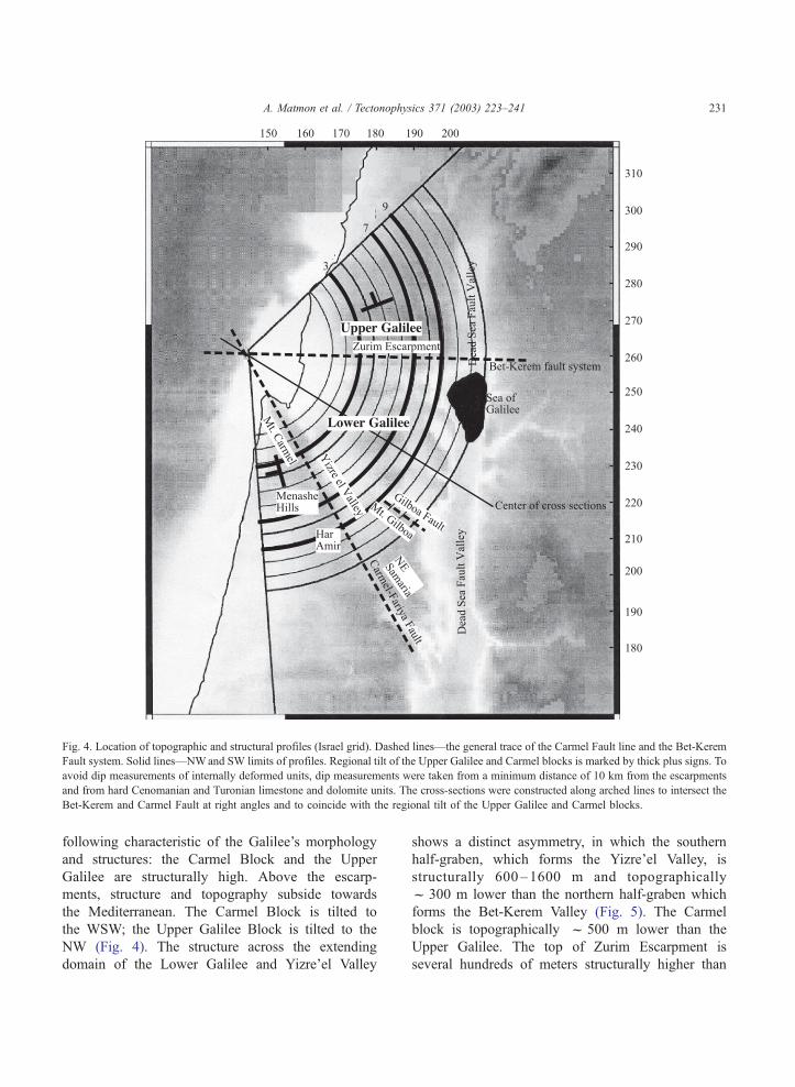
Fig. 4. Location of topographic and structural profiles (Israel grid). Dashed lines—the general trace of the Carmel Fault line and the Bet-Kerem
Fault system. Solid lines—NWand SW limits of profiles. Regional tilt of the Upper Galilee and Carmel blocks is marked by thick plus signs. To
avoid dip measurements of internally deformed units, dip measurements were taken from a minimum distance of 10 km from the escarpments
and from hard Cenomanian and Turonian limestone and dolomite units. The cross-sections were constructed along arched lines to intersect the
Bet-Kerem and Carmel Fault at right angles and to coincide with the regional tilt of the Upper Galilee and Carmel blocks.
A. Matmon et al. / Tectonophysics 371 (2003) 223–241 231
following characteristic of the Galilee’s morphology
and structures: the Carmel Block and the Upper
Galilee are structurally high. Above the escarp-
ments, structure and topography subside towards
the Mediterranean. The Carmel Block is tilted to
the WSW; the Upper Galilee Block is tilted to the
NW (Fig. 4). The structure across the extending
domain of the Lower Galilee and Yizre’el Valley
shows a distinct asymmetry, in which the southern
half-graben, which forms the Yizre’el Valley, is
structurally 600–1600 m and topographically
f 300 m lower than the northern half-graben which
forms the Bet-Kerem Valley (Fig. 5). The Carmel
block is topographically f 500 m lower than the
Upper Galilee. The top of Zurim Escarpment is
several hundreds of meters structurally higher than
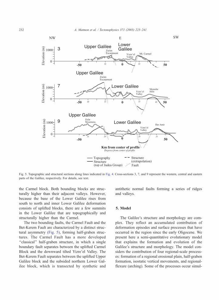
Fig. 5. Topographic and structural sections along lines indicated in Fig. 4. Cross-sections 3, 7, and 9 represent the western, central and eastern
parts of the Galilee, respectively. For details, see text.
A. Matmon et al. / Tectonophysics 371 (2003) 223–241232
the Carmel block. Both bounding blocks are struc-
turally higher than their adjacent valleys. However,
because the base of the Lower Galilee rises from
south to north and inner Lower Galilee deformation
consists of uplifted blocks, there are a few summits
in the Lower Galilee that are topographically and
structurally higher than the Carmel.
The two bounding faults, the Carmel Fault and the
Bet-Kerem Fault are characterized by a distinct struc-
tural asymmetry (Fig. 5), forming half-graben struc-
tures. The Carmel Fault has a more developed
‘‘classical’’ half-graben structure, in which a single
boundary fault separates between the uplifted Carmel
Block and the downward tilted Yizre’el Valley. The
Bet-Kerem Fault separates between the uplifted Upper
Galilee block and the subsided northern Lower Gal-
ilee block, which is transected by synthetic and
antithetic normal faults forming a series of ridges
and valleys.
5. Model
The Galilee’s structure and morphology are com-
plex. They reflect an accumulated contribution of
deformation episodes and surface processes that have
occurred in the region since the early Oligocene. We
present here a semi-quantitative evolutionary model
that explains the formation and evolution of the
Galilee’s structure and morphology. The model con-
siders the contribution of four regional-scale process-
es: formation of a regional erosional plain, half-graben
formation, isostatic vertical movements, and regional-
flexure (arching). Some of the processes occur simul-
A. Matmon et al. / Tectonophys
taneously during the slow and long development
(millions of years) of a fault system. Before presenting
the model, we provide a short description of each the
four processes that shaped the Galilee’s structure and
morphology.
5.1. Geodynamic and morpho-structural processes
5.1.1. Formation of a regional erosional plain
The regression of the Tethys Ocean at the end of
the Eocene was followed by the development of a
westward to northwestward flowing regional drainage
system (Picard, 1943, 1951; Garfunkel and Horovitz,
1966; Nir, 1970; Garfunkel, 1988; Avni, 1990, 1991;
Zilberman, 1992; Garfunkel and Ben-Avraham, 1996;
Begin and Zilberman, 1997). The truncation of the
Eocene carbonate units by the drainage system, ex-
posed the hard limestone and dolomite of the Syrian
Arc anticlines and the soft chalks of the Syrian Arc
synclines. There is no geologic evidence to indicate
high relief at that time, and it is reasonable to assume
that uplift and denudation rates were equal and a low
relief landscape was maintained.
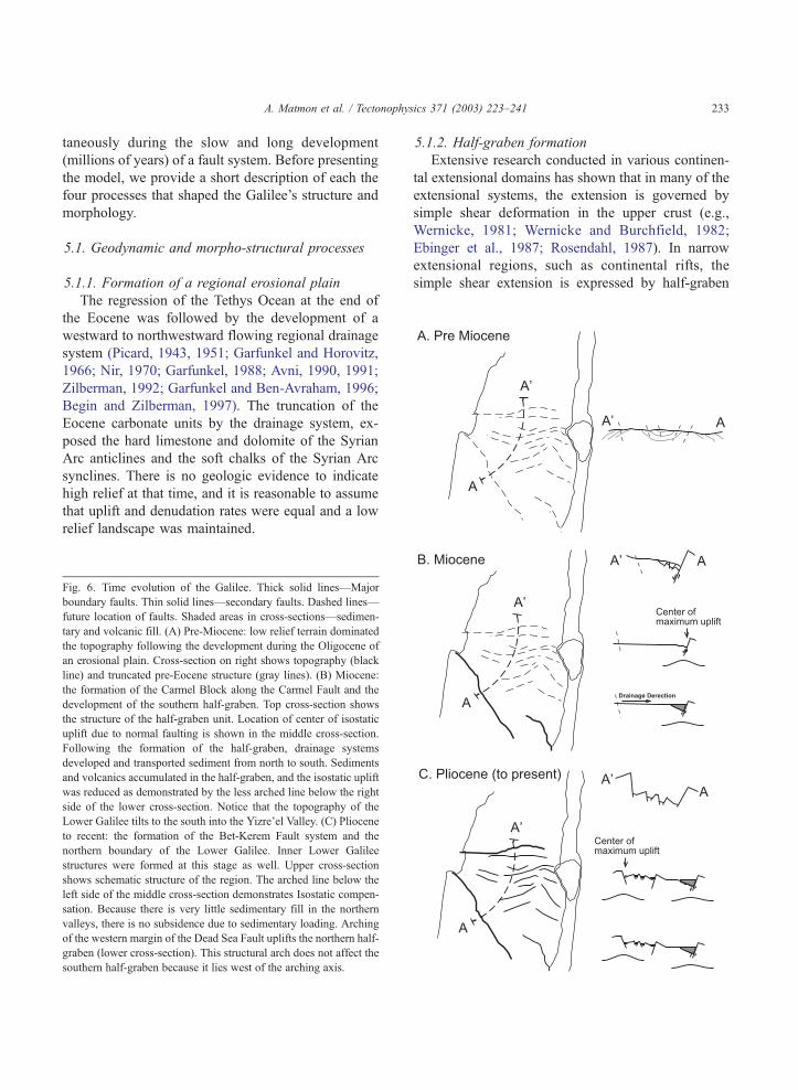
Fig. 6. Time evolution of the Galilee. Thick solid lines—Major
boundary faults. Thin solid lines—secondary faults. Dashed lines—
future location of faults. Shaded areas in cross-sections—sedimen-
tary and volcanic fill. (A) Pre-Miocene: low relief terrain dominated
the topography following the development during the Oligocene of
an erosional plain. Cross-section on right shows topography (black
line) and truncated pre-Eocene structure (gray lines). (B) Miocene:
the formation of the Carmel Block along the Carmel Fault and the
development of the southern half-graben. Top cross-section shows
the structure of the half-graben unit. Location of center of isostatic
uplift due to normal faulting is shown in the middle cross-section.
Following the formation of the half-graben, drainage systems
developed and transported sediment from north to south. Sediments
and volcanics accumulated in the half-graben, and the isostatic uplift
was reduced as demonstrated by the less arched line below the right
side of the lower cross-section. Notice that the topography of the
Lower Galilee tilts to the south into the Yizre’el Valley. (C) Pliocene
to recent: the formation of the Bet-Kerem Fault system and the
northern boundary of the Lower Galilee. Inner Lower Galilee
structures were formed at this stage as well. Upper cross-section
shows schematic structure of the region. The arched line below the
left side of the middle cross-section demonstrates Isostatic compen-
sation. Because there is very little sedimentary fill in the northern
valleys, there is no subsidence due to sedimentary loading. Arching
of the western margin of the Dead Sea Fault uplifts the northern half-
graben (lower cross-section). This structural arch does not affect the
southern half-graben because it lies west of the arching axis.
5.1.2. Half-graben formation
Extensive research conducted in various continen-
tal extensional domains has shown that in many of the
extensional systems, the extension is governed by
simple shear deformation in the upper crust (e.g.,
Wernicke, 1981; Wernicke and Burchfield, 1982;
Ebinger et al., 1987; Rosendahl, 1987). In narrow
extensional regions, such as continental rifts, the
simple shear extension is expressed by half-graben
ics 371 (2003) 223–241 233
A. Matmon et al. / Tectonophysics 371 (2003) 223–241234
structures (e.g., Ebinger et al., 1987; Rosendahl, 1987;
Ebinger, 1989; Wdowinski and Zilberman, 1996,
1997).
5.1.3. Isostatic vertical movements
Isostatic uplift and subsidence occur in response to
changes of rock load within the lithosphere or other
mass load (mostly ice or water) above the lithosphere.
In extensional regions, crustal thinning reduces the
lithospheric rock load causing local or regional iso-
static uplift. The isostatic uplift of the extended region
forms a distinguished morphology, which consists of
an outward tilted elevated footwall adjacent to an
inward tilted structural basin. A well-defined escarp-
ment often marks the transition between the elevated
footwall and the nearby basin. Loading of sediment in
the basins causes the opposite effect of subsidence.
5.1.4. Regional-flexure (arching)
The arching of the western margins of the DSF has
been mentioned and discussed by previous authors
Table 2
Relative elevation contributions of morphologic and geodynamic processe
Stage Time Process Line force
(Nm� 1)
1 Late Eocene to
early Miocene
Formation of erosional plain
(e.g., Garfunkel, 1988)
2 Early Miocene to
early Pliocene
Formation of the Carmel
half-graben structure.
1.7–2.0� 1
3 Early Miocene to
early Pliocene
Subsidence of Yizre’el Valley
and accumulation of volcanics
and sediments.
� (0.8–1.0
4 Early Miocene to
early Pliocene
Formation of a drainage system
that flows from north to south
into the Yizrer’el Valley
(Kafri, 1997)
5 Pliocene Formation of the Bet-Kerem
half-graben structure.
1.8–2.0� 1
6 Early Pleistocene
to recent
Arching and formation of
main water divide (Matmon
et al., 1999)
Total calculated topographic contributions
Total calculated topographic difference between Carmel
and Upper Galilee blocks
Observed topographic elevations
Total observed topographic difference between Carmel
and Upper Galilee blocks
(Picard,1943; Bentor and Vroman, 1951, 1961; Sala-
mon, 1987; Wdowinski and Zilberman, 1996). Some
authors estimated an arching of about 200–400 m
(Ball and Ball, 1953; Salamon, 1987; Matmon et al.,
1999). ten Brink et al. (1990) pointed out the rela-
tionship between the rift axis isostatic compensation
and the topography at the rift’s margins. This type of
arching has been observed in other rifts as well (e.g.,
East African Rift, Rosendahl, 1987; Ebinger, 1989).
Wdowinski and Zilberman (1996) explained the arch-
ing formation as bending (in contrast to buckling that
produces folds under compression) in response to the
formation of the Dead Sea Rift. They attributed the
broad fold structure to three processes: (1) regional
pre-extensional westward strata deposition, (2) local
(20–40 km wide) eastward tilt of the rift’s western
margins, which is the subsided block of the rift’s half-
graben structure, and (3) broad (100 km wide) iso-
static uplift along the Dead Sea Rift. In this study, we
do not attempt to quantify the arching, but rather use
observed values.
s in the Galilee
Elevation (m)
Bet-Kerem
structure
Elevation
(m) Carmel
structure
Note
0 0
011 0 300–350 Isostatic uplift due to
tectonic unloading
� 1011) 0 � (150–175) Isostatic subsidence due
to sedimentary loading
100–200 0 Elevation differences due
the development of the
Yizre’el Valley as base
level. Assuming 0.5%
stream gradients.
011 300–350 0 Isostatic uplift due to
tectonic unloading
150–200 0 Bet-Kerem structure is
on arch axis. Carmel
structure is not
550–750 125–200
350–625
900–1000 450–550
350–550
ophysics 371 (2003) 223–241 235
5.2. Evolutionary model
We use the described processes above to explain,
in a semi-quantitative model, the development of the
Carmel and the Upper Galilee half-grabens and the
elevation differences that developed between them.
5.2.1. Stage 1—Pre-Miocene
In the early Miocene, the study area consisted of
short wavelength (10–20 km wide) synclines and
anticlines of the Syrian Arc fold belt, which were
truncated to a low relief morphology during the
Oligocene (Fig. 6A; Table 2).
5.2.2. Stage 2—Early Miocene
The southern half-graben unit started developing
in the early Miocene (Fig. 6B; Table 2). The forma-
tion of the half-graben caused a local mass deficit,
which was followed by isostatic uplift along the
Carmel Fault. In order to calculate the isostatic uplift
we use an elastic plate model following the formu-
lations of Turcotte and Schubert (1982). The model,
which is applied to long and narrow linear features,
such as fault systems, assumes an infinitely, long
elastic plate that bends upward (or downwards) in
A. Matmon et al. / Tecton
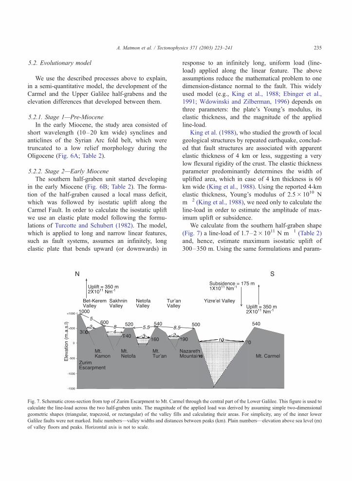
Fig. 7. Schematic cross-section from top of Zurim Escarpment to Mt. Carm
calculate the line-load across the two half-graben units. The magnitude of
geometric shapes (triangular, trapezoid, or rectangular) of the valley fills
Galilee faults were not marked. Italic numbers—valley widths and distance
of valley floors and peaks. Horizontal axis is not to scale.
response to an infinitely long, uniform load (line-
load) applied along the linear feature. The above
assumptions reduce the mathematical problem to one
dimension-distance normal to the fault. This widely
used model (e.g., King et al., 1988; Ebinger et al.,
1991; Wdowinski and Zilberman, 1996) depends on
three parameters: the plate’s Young’s modulus, its
elastic thickness, and the magnitude of the applied
line-load.
King et al. (1988), who studied the growth of local
geological structures by repeated earthquake, conclud-
ed that fault structures are associated with apparent
elastic thickness of 4 km or less, suggesting a very
low flexural rigidity of the crust. The elastic thickness
parameter predominantly determines the width of
uplifted area, which in case of 4 km thickness is 60
km wide (King et al., 1988). Using the reported 4-km
elastic thickness, Young’s modulus of 2.5� 1010 N
m� 2 (King et al., 1988), we need only to calculate the
line-load in order to estimate the amplitude of max-
imum uplift or subsidence.
We calculate from the southern half-graben shape
(Fig. 7) a line-load of 1.7–2� 1011 N m� 1 (Table 2)
and, hence, estimate maximum isostatic uplift of
300–350 m. Using the same formulations and param-
el through the central part of the Lower Galilee. This figure is used to
the applied load was derived by assuming simple two-dimensional
and calculating their areas. For simplicity, any of the inner lower
s between peaks (km). Plain numbers—elevation above sea level (m)
A. Matmon et al. / Tectonophysics 371 (2003) 223–241236
eters, we calculate that the sediment line-load in the
Yizre’el Valley is 0.8–1.0� 1011 N m� 1 (Table 2),
causing a maximum subsidence of 150–175 m, half
of the uplift value. Thus, the total uplift of the Carmel
morpho-structural unit due to isostatic response was
about 150–175 m.
As a result of the subsidence of the Yizre’el Valley,
a drainage system that drained the Galilee southward
into the Yizre’el Valley developed (Fig. 6B, Kafri,
1997). This implies that the northern Lower Galilee
was 100–200 m higher than the Yizre’el Valley (if
considering a 0.5% alluvial gradient) when later
faulting that formed the northern boundary half-gra-
ben and other blocks in the Lower Galilee begun
operating.
5.2.3. Stage 3
A second isostatically supported half-graben mor-
pho-structural unit started developing in the Pliocene
across the Bet-Kerem Fault system in response to a
N–S extensional stress field. Synthetic and antithetic
normal faults developed within the down flexed
hanging wall and formed the horst and graben
morphology of the Lower Galilee (Fig. 6C). We
calculate from the northern half-graben shape a
line-load of 1.7–2� 1011 N m� 1 (Fig. 7, Table 2)
and, hence, estimate maximum isostatic uplift of
300–350 m. The insignificant sedimentary loading
in the northern valleys resulted in a negligible basin
subsidence.
The arching of the western margins of the DSF
(Wdowinski and Zilberman, 1997) caused the uplift of
the mountain ranges along an N–S axis. In the Galilee,
the arching contributed about 150–200 m of elevation
during the Pleistocene (Matmon et al., 1999). The axis
of the N–S trending arch crosses the Bet-Kerem Fault
and, thus, influences it and the upper Galilee block.
However, the Carmel block lies west of the axis, and
was only marginally influenced by this regional uplift
(Fig. 6C).
Together, the total contribution to the elevation of
the Carmel structure from the isostatic compensation,
regional tilt, and arching is 125–200 m while for the
Bet-Kerem structure it is 550–750. The processes
described above and summarized in Table 2 explain
the difference in topographic elevation between the
two uplifted margins in spite of their similar vertical
displacement.
6. Discussion
The results of our study show that the present
structure and morphology of the Galilee were formed
by the development of two half-graben units. The
southern one started developing in the early Miocene
and the northern one in the Pliocene. Although both
boundary blocks are similar in many aspects such as
the amount of stratigraphic displacement and isostatic
uplift (calculated in our model), the two boundary
faults of the extending region differ from one another
in their orientation, topographic elevation, and struc-
tural elevation. In this section, we discuss the causes
for the observed differences and also provide explan-
ations for the causes.
The two boundary fault systems, the older Carmel
Fault and the younger Bet-Kerem Fault, are oriented at
45j to one another. The older Carmel Fault is oriented
NW–SE, whereas the younger Bet-Kerem Fault is
oriented E–W. This observed orientation difference
was caused by the varying stress field that shaped the
Galilee and the entire Levant structures (Eyal and
Reches, 1983; Ron and Eyal, 1985; Eyal, 1996). Since
the Miocene, the region was subjected to predominant-
ly extensional stress field associated with the breakup
of the Arabo–Nubian plate. The formation of the
Carmel Fault during an early Miocene rifting period
occurred contemporaneously to the formation of the
Red Sea and the Gulf of Suez (which are sub-parallel to
the Carmel Fault) in response to an ENE–WSW
regional extensional stress field (Garfunkel, 1981).
However, during the middle and late Miocene trans-
current faulting occurred throughout the Levant form-
ing the DSF under ENE–WSWextension and NNW–
SSE compression. Throughout the Galilee, a local
stress-field of E–W compression and N–S extension
generated left lateral displacement along the Carmel
Fault and formed NE–SW right-lateral trending faults
and their conjugate NW–SE left-lateral trending faults
(Ron and Eyal, 1985). Since the Pliocene, the E–W
compressional component of the stress-field has been
significantly reduced; thus the Galilee has been sub-
jected to N–S extension occurring along E–W normal
faults (Ron and Eyal, 1985) and a broad E–W folding,
the arching. Thus, the 45j orientation difference be-
tween the northern and southern boundary faults of the
Lower Galilee is, therefore, the result of the different
stress fields under which each fault developed.
A. Matmon et al. / Tectonophysics 371 (2003) 223–241 237
Although the shallow structure of both fault sys-
tems is similar along the opposite facing half-grabens,
the Galilee deep structure reflects significant differ-
ences. The deep structure of the Lower Galilee has
been interpreted from magnetic and gravimetric anom-
aly maps (e.g., Ginzburg, 1970; May, 1987; Shirman,
2000; Rybakov et al., 2000). May (1987) pointed out
that the gravimetric signal north of the Carmel Fault
generally rises from east to west towards the Mediter-
ranean. This phenomenon, which was not observed
south of the Carmel Fault, apparently stems from a
thinner crust north of the Carmel Fault compared to the
crust south of it indicating a change in crust properties
along the Carmel line (Ginzburg et al., 1994). The
positive gravimetric anomaly along the length of the
Carmel Fault of about 30 to 35 mGal was interpreted
as either representing the existence of an intrusive
body at a depth of 3–5 km or by the deformation of
the basement by the deep Carmel Fault (May, 1987;
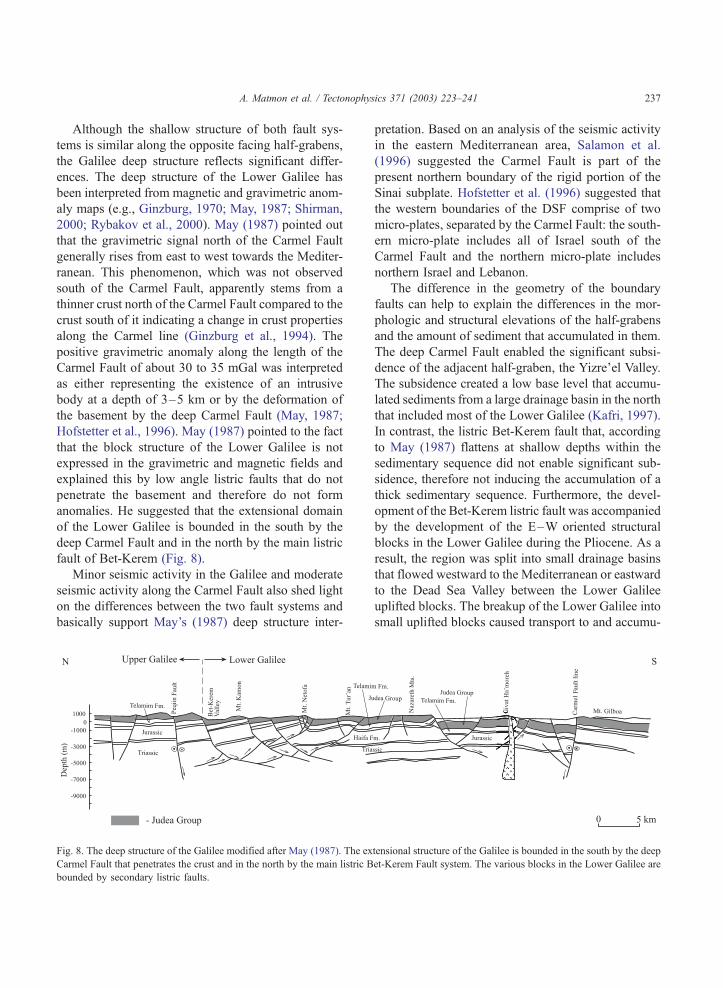
Hofstetter et al., 1996). May (1987) pointed to the fact
that the block structure of the Lower Galilee is not
expressed in the gravimetric and magnetic fields and
explained this by low angle listric faults that do not
penetrate the basement and therefore do not form
anomalies. He suggested that the extensional domain
of the Lower Galilee is bounded in the south by the
deep Carmel Fault and in the north by the main listric
fault of Bet-Kerem (Fig. 8).
Minor seismic activity in the Galilee and moderate
seismic activity along the Carmel Fault also shed light
on the differences between the two fault systems and
basically support May’s (1987) deep structure inter-
Fig. 8. The deep structure of the Galilee modified after May (1987). The ex
Carmel Fault that penetrates the crust and in the north by the main listric B
bounded by secondary listric faults.
pretation. Based on an analysis of the seismic activity
in the eastern Mediterranean area, Salamon et al.
(1996) suggested the Carmel Fault is part of the
present northern boundary of the rigid portion of the
Sinai subplate. Hofstetter et al. (1996) suggested that
the western boundaries of the DSF comprise of two
micro-plates, separated by the Carmel Fault: the south-
ern micro-plate includes all of Israel south of the
Carmel Fault and the northern micro-plate includes
northern Israel and Lebanon.
The difference in the geometry of the boundary
faults can help to explain the differences in the mor-
phologic and structural elevations of the half-grabens
and the amount of sediment that accumulated in them.
The deep Carmel Fault enabled the significant subsi-
dence of the adjacent half-graben, the Yizre’el Valley.
The subsidence created a low base level that accumu-
lated sediments from a large drainage basin in the north
that included most of the Lower Galilee (Kafri, 1997).
In contrast, the listric Bet-Kerem fault that, according
to May (1987) flattens at shallow depths within the
sedimentary sequence did not enable significant sub-
sidence, therefore not inducing the accumulation of a
thick sedimentary sequence. Furthermore, the devel-
opment of the Bet-Kerem listric fault was accompanied
by the development of the E–W oriented structural
blocks in the Lower Galilee during the Pliocene. As a
result, the region was split into small drainage basins
that flowed westward to the Mediterranean or eastward
to the Dead Sea Valley between the Lower Galilee
uplifted blocks. The breakup of the Lower Galilee into
small uplifted blocks caused transport to and accumu-
tensional structure of the Galilee is bounded in the south by the deep
et-Kerem Fault system. The various blocks in the Lower Galilee are
A. Matmon et al. / Tectonophysics 371 (2003) 223–241238
lation of sediments in the Yizre’el Valley to decrease
significantly and did not enable the accumulation of
sediment in the Bet-Kerem Valley.
The absolute topographic elevation of the bound-
ary blocks is dictated by several factors such as their
location relative to regional uplift axis and the abso-
lute amount of displacement along the Bet-Kerem and
Carmel faults. Our model cannot explain the absolute
elevations of each of the blocks since there are no
markers to signify surface uplift in the region (Eng-
land and Molnar, 1990; Molnar and England, 1990).
However, the model can explain the difference in
elevation between the two boundary blocks.
The elevation differences between the northern and
southern bounding blocks can be explained consider-
ing several factors (Table 2): (1) Elevation differences
that existed during the time interval between the
formation of the southern half-graben and the northern
one (Fig. 6B). (2) The influence of the N–S trending
structural arch that formed the mountainous backbone
of Israel (Fig. 6C). (3) Difference in isostatic compen-
sation due to sedimentary loading (Fig. 6). The
combination of the elevation contribution of the
described processes helps to explain the differences
in structural and topographic elevations between the
two boundary half-grabens and blocks of the Lower
Galilee. We calculated similar amounts of isostatic
uplift as response to normal faulting along the Bet-
Kerem faults system and the Carmel Fault. However,
the uplift was enhanced along the Bet-Kerem faults
system by regional arching, and negated along the
Carmel Fault by substantial loading of sediments in
the Yizre’el Valley. Thus, according to the model
calculations, an elevation difference of 350–625 (av-
erage, f 485) m should develop between the bound-
ary blocks. This value agrees with the actual differ-
ence of 350–550 (average, f 450) m between the
Carmel Block and top of Zurim Escarpment.
7. Conclusions
The results of our study suggest that the morpho-
logic and tectonic history of the Lower Galilee, the
Yizre’el Valley, and their adjacent bounding blocks
are best described by a set of two opposite facing half-
grabens. Total extension in the Galilee was achieved
by the formation of two half-grabens under varying
stress fields. The formation of the southern half-
graben during the Miocene occurred under a stress
field related to the opening of the Red Sea and the
Gulf of Suez (and other basins in the region). The
subsidence of the half-graben along the deep-seated
Carmel Fault formed the Yizre’el Valley. The drainage
basin of the Yizre’el Valley was extensive and enabled
the delivery and accumulation of sediments into the
valley. As a consequence, the isostatic uplift of the
half-graben unit was negated by subsidence caused by
sedimentary load.
The second, northern half-graben was formed
along the listric Bet-Kerem fault system during the
Pliocene and occurred under a stress field related to
the development of the DSF. The development of the
block structure within the Lower Galilee occurred at
this time and several small drainage systems devel-
oped between the uplifted blocks. Thus, only little
sedimentary accumulation could take place in the
northern half-graben. Furthermore, the extensive
drainage basin that transported sediments to the Yiz-
re’el Valley was significantly reduced and sediment
accumulation rate decreased. The shallow listric fault
that formed the northern boundary did not cause
significant subsidence and the small drainage basins
did not transport substantial amounts of sediments to
the northern half-graben. Thus, the isostatic uplift of
the northern half-graben unit was not followed by
accumulation of sediments and subsidence.
In summary, the two half-grabens differ from one
another by their orientation, structural and topograph-
ic elevation. The southern half-graben is deeper,
exceeds to a depth of 1500 m, and is filled with
Miocene–Pliocene sediments and volcanic rocks. The
northern half-graben exceeds up to 800 m of vertical
offset and is hardly filled with sediments. However,
the northern uplifted block is topographically higher
by 400–600 m than the southern one. The differences
between the two half-grabens are attributed to original
elevation differences, the thick fill of volcanics and
sediments along the southern half-graben, and the
influence of arching on the northern half-graben.
Acknowledgements
We thank P. Bierman, K. Nichols, S. Hurwitz, and
S. Marco for collegial reviews of early drafts of the
A. Matmon et al. / Tectonophysics 371 (2003) 223–241 239
manuscript, and Z. Garfunkel and A. Agnon for
fruitful discussions and ideas. We are thankful to two
anonymous reviewers for their helpful comments.
References
Achmon, M., 1986. The Carmel border fault between Yoqneam and
Nesher (in Hebrew, English abstract). MSc thesis, Hebrew Uni-
versity of Jerusalem, Jerusalem. 56 pp.
Achmon, M., Ben-Avraham, Z., 1997. The deep structure of the
Carmel Fault zone, northern Israel, from gravity field analysis.
Tectonics 16 (3), 563–569.
Avni, Y., 1990. The paleogeography and the evolution of the land-
scape in the western part of the central Negev, and the relation-
ship to the evolution of Makhtesh–Ramon. In: Lavee, H.,
Schick, A., Yair, A. (Eds.), Facets of the Geomorphology of
the Negev. The Israel Geomorphological Society, pp. 67–84.
Avni, Y., 1991. The geology, paleogeography and landscape evo-
lution of the Negev highlands and the western Ramon structure.
Geological Survey of Israel, Report GSI/6/91. 153 pp.
Ball, M.H., Ball, D., 1953. Oil prospects of Israel. Bulletin of
American Association of Petroleum Geologists 37, 1–113.
Begin, Z.B., Zilberman, E., 1997. Main stages and rates of relief
development in Israel. Geological Survey of Israel, Report GSI/
24/97. 63 pp.
Belitzki, S., 1997. Tectonic geomorphology of the lower Jordan
Valley—an active continental rift (in Hebrew with extended
English abstract). PhD Thesis, Hebrew University of Jerusalem,
Jerusalem. 98 pp.
Ben-Gai, Y., Ben-Avraham, Z., 1995. Tectonic processes in off-
shore northern Israel and the evolution of the Carmel structure.
Marine and Petroleum Geology 12, 533–548.
Bentor, Y.K., Vroman, A.J., 1951. Map of the Negev. Sheet 18:
Avedat, scale 1:100,000, Israel Army SCI. 98 pp.
Bentor, Y.K., Vroman, A.J., 1961. Map of the Negev. Sheet 16: Mt.
Sedom, scale 1:100,000, Israel Army SCI. 98 pp.
Cohen, Z., 1988. Hydrocarbon Potential of Israel, Highlights of
Basin Analysis. Oil Exploration in Israel Ltd., Exploration De-
partment. 79 pp.
Dvorkin, A., Kohn, B.P., 1989. The Asher Volcanics, northern Is-
rael: petrography, mineralogy and alteration. Israel Journal of
Earth Sciences 38, 105–123.
Ebinger, C.J., 1989. Tectonic development of the western branch of
the East African rift system. Geological Society of America
Bulletin 101, 885–903.
Ebinger, C.J., Rosendahl, B.R., Reynolds, D., 1987. Tectonic model
of the Malawi rift, Africa. Tectonophysics 141, 215–235.
Ebinger, C.J., Karner, G.D., Weissel, J.K., 1991. Mechanical
strength of extended continental lithosphere: constraints from
the western rift system, east Africa. Tectonics 10, 1239–1256.
Eliezri, I.Z., 1965. The geology of the Beit –Jann region (Galilee,
Israel). Israel Journal of Earth Sciences 14, 51–66.
Ellenblum, R., Marco, S., Agnon, A., Rockwell, T., 1998. Crusader
castle torn apart by earthquake at dawn, 20 May, 1202. Geology
26 (4), 303–306.
England, P., Molnar, P., 1990. Surface uplift, uplift of rocks, and
exhumation of rocks. Geology 18, 1173–1177.
Eyal, Y., 1996. Stress field fluctuations along the Dead Sea Rift
since the middle Miocene. Tectonics 15 (1), 157–170.
Eyal, Y., Reches, Z., 1983. Tectonic analysis of the Dead Sea Rift
region since the Late Cretaceous based on mesostructures. Tec-
tonics 2 (2), 167–185.
Flexer, A., Freund, R., Reiss, Z., Buchbinder, B., 1970. Santonian
paleostructure of the Galilee. Israel Journal of Earth Sciences
19, 141–146.
Freund, R., 1965. A model of the structural development of Israel
and adjacent areas since Upper Cretaceous times. Geology Mag-
azine 102, 189–205.
Freund, R., 1970. The geometry of faulting in Galilee. Israel Journal
of Earth Sciences 19, 117–140.
Garfunkel, Z., 1970. The tectonics of the western margins of the
southern Arava (in Hebrew, English abstract). PhD thesis, He-
brew University of Jerusalem, Jerusalem. 204 pp.
Garfunkel, Z., 1978. The Negev—regional synthesis of sedimentary
basins. Tenth International Congress of Sedimentology, Jerusa-
lem, Guidebook to Excursions 1, 33–110.
Garfunkel, Z., 1981. Internal Structure of the Dead Sea leaky trans-
form (rift) in relation to plate kinematics. Tectonophysics 80,
81–108.
Garfunkel, Z., 1988. The pre-Quaternary geology of Israel. In:
Yom-Tov, Y., Tchernov, E.W. (Eds.), The Zoogeography of Is-
rael. Junk, The Hague, Netherlands, pp. 7–34.
Garfunkel, Z., Horovitz, A., 1966. The Upper Tertiary and Quater-
nary morphology of the Negev. Israel Journal of Earth Sciences
15, 101–117.
Garfunkel, Z., Derin, B., 1984. Permian–early Mesozoic tectonism
and continental margin formation in Israel and its implications
for the history of the eastern Mediterranean. In: Dixon, J.E.,
Robertson, A.H.F. (Eds.), The Geological Evolution of the
Eastern Mediterranean. Geological Society Special Publication,
vol. 17, pp. 187–201.
Garfunkel, Z., Almagor, G., 1985. Geology and structure of the
continental margin off northern Israel and the adjacent part of
the Levantine basin. Marine Geology 62, 105–131.
Garfunkel, Z., Ben-Avraham, Z., 1996. The structure of the Dead
Sea Basin. Tectonophysics 266, 155–176.
Ginzburg, A., 1970. The Gravity Map of Israel. Atlas of Israel,
2nd ed. Survey of Israel, Jerusalem and Elsevier, Amsterdam.
Ginzburg, A., Ben-Avraham, Z., Makris, J., Hubral, P., Rotstien, Y.,
1994. Crustal structure of northern Israel. Marine and Petroleum
Geology 11 (4), 501–506.
Glikson, Y.A., 1966. Geology of the Southern Naftali Mountains
(northeastern Galilee, Israel). Israel Journal of Earth Sciences
15, 135–154.
Golani, U., 1957. The Geology of the Meghar region (in Hebrew).
MSc thesis, Hebrew University of Jerusalem, Jerusalem. 54 pp.
Gran-Mitchel, S.E., Matmon, A., Bierman, P.R., Rizzo, D., Enzel,
Y., Caffee, M., 2001. Determination of displacement history
from a limestone normal fault scarp using cosmogenic 36Cl,
northern Israel. Journal of Geophysical Research 106 (B3),
4247–4264.
Hall, J.K., 1993. The GSI digital terrain model (DTM) project
A. Matmon et al. / Tectonophysics 371 (2003) 223–241240
completed. Geological Survey of Israel Current Research 8,
47–50.
Hall, J.K., 1996. Topography and bathymetry of the Dead Sea
depression. Tectonophysics 266, 177–185.
Heimann, A., 1990. The development of the Dead Sea Transform
and its margins in northern Israel during the Pliocene and Pleis-
tocene (in Hebrew, English summary). Geological Survey of
Israel, Report GSI/28/90. 83 pp.
Hofstetter, A., Van-Eck, T., Shapira, A., 1996. Seismic activity along
branches of the Dead Sea–Jordan Transform system: The Car-
mel–Tirtza fault system. Tectonophysics 267, 317–330.
Hurwitz, S., Garfunkel, Z., Ben-Gai, Y., Reznikov, M., Rotstein,
Y., Gvirtzman, H., 2002. The tectonic framework of a com-
plex pull-apart basin; seismic reflection observations in the
Sea of Galilee, Dead Sea Transform. Tectonophysics 359,
289–306.
Issar, A., Kafri, U., 1972. Neogene and Pleistocene Geology of the
Western Galilee Coastal Plain. Geological Survey of Israel Bul-
letin 53. 14 pp.
Kafri, U., 1972. The geological map of Israel, Nahariyya. Geolog-
ical Survey of Israel, Ministry of Development, State of Israel,
scale 1:50,000, Sheet 1-IV.
Kafri, U., 1997. Neogene to Quaternary drainage systems and their
relationship to young tectonics: Lower Galilee, Israel. Geolog-
ical Survey of Israel, Report GSI/1/97. 50 pp.
Kafri, U., Ecker, A., 1964. Neogene and Quaternary subsurface
geology and hydrology of the Zevulun Plain. Geological Survey
of Israel Bulletin 37. 13 pp.
Karcz, Y., 1959. The structure of the northern Carmel. Bulletin of
the Research Council of Israel 80G, 119–130.
Kashai, E., Picard, L., 1958. On the lithostratigraphy and tectonics
of the Carmel. Bulletin of the Research Council of Israel 7G (1),
1–19.
King, G.C., Stein, R.S., Rundle, J., King, B., 1988. The growth
of geological structures by repeated earthquakes: 1. Concep-
tual framework. Journal of Geophysical Research 93 (11),
13307–13318.
Krenkel, E., 1924. Der Syrische Bogen. Zentralblatt Mineralogie 9,
274–281.
Levy, Y., 1983. The geological map of Israel, Shefar’am. Geolog-
ical Survey of Israel, Ministry of Development, State of Israel,
scale 1:50,000, Sheet 3-II.
Marco, S., Agnon, A., Ellenblum, R., Eidelman, A., Basson, U.,
Boas, A., 1997. 817 year old walls offset sinistrally 2.1 m by the
Dead Sea Transform, Israel. Journal of Geodynamics 24 (1–4),
11–20.
Matmon, A., Enzel, Y., Zilberman, E., Heimann, A., 1999. Late
Pliocene and Pleistocene reversal of drainage systems in
northern Israel: tectonic implications. Geomorphology 28,
43–59.
Matmon, A., Zilberman, E., Enzel, Y., 2000. Determination of es-
carpment age using morphologic analysis: an example from the
Galilee, northern Israel. Geological Society of America Bulletin
112 (12), 1864–1876.
May, P.R., 1987. Oil and Gas Potential of the Galilee, Israel, Report
87/12. Oil Exploration of Israel Ltd., Exploration Department.
79 pp.
Mero, D., 1983. Subsurface geology of western Galilee and Zevu-
lun plain. Tahal Consulting Engineering Ltd.
Molnar, P., England, P., 1990. Late Cenozoic uplift of mountain
ranges and global climate change: chicken or egg? Nature 346
(6279), 29–34.
Mor, D., Levitte, D., Steinitz, G., Lang, B., 1987. The volcanic
history of the Ramat Dalton (Upper Galilee) according to
K–Ar dating. Israel Geological Society, Annual Meeting, 93.
Nir, D., 1970. Geomorphology of Israel. Aqademon, Jerusalem,
Israel. 404 pp.
Picard, L., 1943. Structure and evolution of Palestine with compa-
rative notes on neighboring countries. Hebrew University, Jer-
usalem, Geological Department Bulletin 4. 134 pp.
Picard, L., 1951. Geomorphogeny of Israel. Part 1—The Negev.
The Bulletin of the Research Council of Israel 8G, 1–30.
Picard, L., Golani, U., 1965. The Geological Map of Israel, North-
ern Sheet, 1:250,000, Mapping Division, Israel.
Quennell, A.M., 1959. Tectonics of the Dead Sea rift. 20th Interna-
tional Geological Congress. Association of Surveying Geolo-
gists, Africanos, Mexico, pp. 385–405.
Ron, H., Eyal, Y., 1985. Interplate deformation by block rotation
and mesostructures along the Dead Sea Transform, northern
Israel. Tectonics 4 (1), 85–105.
Ron, H., Freund, R., Garfunkel, Z., Nur, A., 1984. Block rotation
by strike slip faulting: structural and paleomagnetic evidence.
Journal of Geophysical Research 89, 6256–6270.
Rosendahl, B.R., 1987. Architecture of continental rift with special
reference to East Africa. Annual Review of Earth Planetary
Sciences 15, 445–503.
Rybakov, M., Goldshmidt, V., Fleischer, L., Ben-Gai, Y., 2000. 3-D
gravity and magnetic interpretation for the Haifa Bay area (Is-
rael). Journal of Applied Geophysics 44, 353–367.
Salamon, A., 1987. The monoclines in the northern Negev: a model
of tilted blocks and shortening (in Hebrew with English abstract).
MSc thesis, Hebrew University of Jerusalem, Jerusalem. 101 pp.
Salamon, A., Hofstetter, A., Garfunkel, Z., Ron, H., 1996. Seismic-
ity of the eastern Mediterranean region: perspective from the
Sinai subplate. Tectonophysics 263, 293–305.
Saltzman, U., 1964. The geology of the Tabha–Huquq–Migdal
area (in Hebrew). MSc thesis, Hebrew University of Jerusalem,
Jerusalem. 55 pp.
Schulman, N., 1959. The geology of the Central Jordan Valley.
Bulletin of the Research Council of Israel 8G, 63–90.
Schulman, N., 1962. The geology of the Central Jordan valley (in
Hebrew). PhD thesis, Hebrew University of Jerusalem, Jerusa-
lem. 103 pp.
Shaliv, G., 1991. Stages in the tectonic and volcanic history of the
Neogene basin in the Lower Galilee and the valleys. Geological
Survey of Israel, Report GSI/11/91. 101 pp.
Shirman, B., 2000. Three component magnetic anomaly maps of
Israel. Israel Journal of Earth Sciences 49, 1–7.
Sivan, D., 1996. Paleogeography of the Galilee coastal plain during
the Quaternary (in Hebrew). Geological Survey of Israel, Report
GSI/18/96. 228 pp.
Sivan, D., Gvirtzman, G., Sass, E., 1999. Quaternary stratigraphy
and paleogeography of the Galilee Coastal Plain. Quaternary
Research 51, 280–294.
A. Matmon et al. / Tectonophysics 371 (2003) 223–241 241
ten Brink, U.S., Schoenberg, N., Kovach, R.L., Ben-Avraham, Z.,
1990. Uplift and possible Moho offset across the Dead Sea
transform. In: Kovach, R.L., Ben-Avraham, Z. (Eds.), Geologic
and Tectonic Processes of the Dead Sea Transform Zone. Tec-
tonophysics, vol. 180, pp. 71–85.
Turcotte, D.L., Schubert, G., 1982. Geodynamics, Application of
Continuum Physics to Geological Problems. Wiley, New York.
450 pp.
Wdowinski, S., Zilberman, E., 1996. Kinematic modeling of large
scale structural asymmetry across the Dead Sea Transform. Tec-
tonophysics 266, 187–201.
Wdowinski, S., Zilberman, E., 1997. Systematic analyses of the
large-scale topography and structure across the Dead Sea Rift.
Tectonics 16, 409–424.
Wernicke, B.P., 1981. Low-angle normal faults in the Basin and
Range province: nappe tectonics in an extending orogen. Nature
291, 645–648.
Wernicke, B.P., Burchfield, B.C., 1982. Modes of extensional tec-
tonics. Journal of Structural Geology 4, 105–115.
Zilberman, E., 1992. Remnants of Miocene landscape in the central
and northern Negev and their paleogeographic implications. Is-
rael Geological Survey Bulletin 83. 54 pp.