Embed Size (px)
Citation preview

Placed on: Osaka City University Repository
Title Morphological Changes in the Beaches Causefd by Tsunami in Between Pondicherry and Portonova East Coast of India
Author Vasudevan, Sivapakasam / Arumugam, Marimuthu / Srinivasamoorthy, Krishnaraj / Anadhan, Paulsamy / Chidambaram, Sabarathinam
Citation Journal of geosciences Osaka City University 50; 83-91. Issue Date 2007-03
ISSN 0449-2560 Type Departmental Bulletin Paper
Textversion Publisher Publisher Graduate School of Science, Osaka City University
Description
Placed on: Osaka City University Repository

Journal of Geosciences, Osaka City University
Vol. 50, Art. 7, p. 83-91, March, 2007
Morphological Changes in the Beaches Caused by Tsunami In
Between Pondicherry and Portonova, East Coast of India
Sivaprakasam VASUDEVAN*, Marimuthu ARUMUGAM, Krishnaraj SRINIVASAMOORTHY,Paulsamy ANADHAN and Sabarathinam CHIDAMBARAM
Department of Earth Sciences, Annamalai University, Annamalai Nagar - 608002, Tamilnadu, India
* Corresponding author (e-mail: [email protected])
Abstract
Waves caused as a result of earthquakes occurring at the sea bottom are known as tsunami.
Tamilnadu coastal region in South India is also one amongst the tsunami affected regions of the world.
In the present study, the region between Pondicherry and Portonova has been given much attention to
evaluate the impact of tsunami over beaches. Slope of the coastal region has been reduced and nearly
flattened. The berm sediments have been washed away. From north (Pondicherry) to south
(Portonova), it clearly exhibits the effect by increased death toll, destruction and modification in the
landforms. The stony waste dump in Pondicherry and Ponniyar - Gadilam river mouth in Cuddalore
region reduced the impact of tsunami. The single giant wave altered the coastal landforms by means of
destructing the cliff and flattening the beach. Imprints like swash marks and adhesion ripples are noted
in the Silver beach of Cuddalore. The study reveals that this giant wave has destroyed older
expressions made by ordinary wave action over hundreds of years and left its imprints over them.
Key-words: tsunami, coastal landforms, beach, Tamilnadu coast.
1. Introduction
A eries of gigantic waves triggered In a body of
water by disturbance due to earthquake vertically displaces
water column and leads to wall of water, hitting the shore
with tremendous energy and leaving behind a trail of
destructions. Such event has occurred on 26th December
2004, which is the one among the worst in the world has
faced so far. Magnitude of 9 is the 5th largest earthquake
ever recorded in the history (Gupta, 2005). This has created
series of massive ocean waves and caused devastating
inundation in south eastern coastline of India and eastern
coastline of Sri Lanka. Since Sri Lanka acted as a barrier
for this quake waves, coastal region in India from Point
Cali mer to Tuticorin becomes the shadow zone. The prime
objective of the present study is to infer the impact of
tsunami over morphological changes in beaches of centra]
Tamilnadu coast.
2. Area of Study
Geomorphology of northern Tamilnadu coast,
extending from Pulicat Lake in the north to Vedaranniam
nose in the south, is unique in the world. The coastal zone
is varying in its width from 10 m to as far as 100 m. It is
vested with numerous deltas such as Palar, Ponniyar and
Cauvery from north to south. The area of study forms a
part of northern Tamilnadu coast, located in the East coast
of India, bounded by Bay of Bengal. It extends between
Pondicherry in the north and Portonova in the south
between latitudes ]2°0' to 11°30' N and longitude 79°] 5'
to 79°51 ' E (Fig. I).
3. Method
Extensive fieldwork was carried out to study and
confi.rm the changes over different geomorphic features in
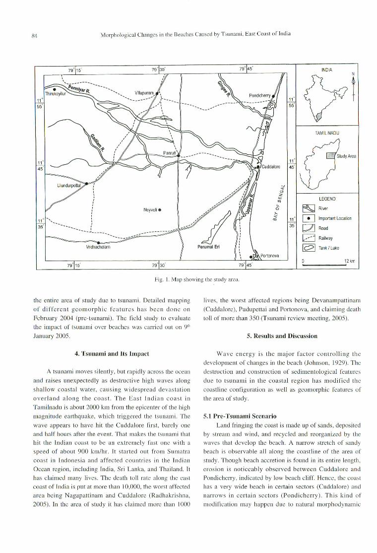
84 Morphological Changes in the Beaches Caused by Tsunami, East Coast of India
N
tINDIA
TAMILNADU
....,
"0."I.J.J LEGEND
<l>u.. E§J River0
>..
" 11° [!] Important Location<l>
35 c:2J Road
D Railway
~ Tank I Lake
0 12 km, .
-....... _.........
Neyveli •
------..........
Vridhachalam
---- .....'-,
-----~
Fig. 1. Map showing the study area.
the entire area of study due to tsunami. Detailed mapping
of different geomorphic features has been done on
February 2004 (pre-tsunami). The field study to evaluate
the impact of tsunami over beaches was carried out on 9th
January 2005.
lives, the worst affected regions being Devanampattinam
(Cuddalore), Pudupettai and Portonova, and claiming death
toll of more than 350 (Tsunami review meeting, 2005).
5. Results and Discussion
4. Tsunami and Its Impact
A tsunami moves silently, but rapidly across the ocean
and raises unexpectedly as destructive high waves along
shallow coastal water, causing widespread devastation
overland along the coast. The East Indian coast in
Tamilnadu is about 2000 km from the epicenter of the high
magnitude earthquake, which triggered the tsunami. The
wave appears to have hit the Cuddalore first, barely one
and half hours after the event. That makes the tsunami that
hit the Indian coast to be an extremely fast one with a
speed of about 900 km/hr. It started out from Sumatra
coast in Indonesia and affected countries in the Indian
Ocean region, including India, Sri Lanka, and Thailand. It
has claimed many lives. The death toll rate along the east
coast of India is put at more than 10,000, the worst affected
area being Nagapattinam and Cuddalore (Radhakrishna,
2005). In the area of study it has claimed more than 1000
Wave energy is the major factor controlling the
development of changes in the beach (Johnson, 1929). The
destruction and construction of sedimentological features
due to tsunami in the coastal region has modified the
coastline configuration as well as geomorphic features of
the area of study.
5.1 Pre-Tsunami ScenarioLand fringing the coast is made up of sands, deposited
by stream and wind, and recycled and reorganized by the
waves that develop the beach. A narrow stretch of sandy
beach is observable all along the coastline of the area of
study. Though beach accretion is found in its entire length,
erosion is noticeably observed between Cuddalore and
Pondicheny, indicated by Jow beach cliff. Hence, the coast
has a very wide beach in certain sectors (Cuddalore) and
narrows in certain sectors (Pondicherry). This kind of
modification may happen due to natural morphodynamic

S. VASUDEVAN, M. ARUMUGAM, K. SRI IVASAMOORTHY, P. ANADHA . and S. CHIDAMBARAM 85
processes.
Though the nature and form of beaches are different
in different sectors, two prominent types are noticed (Fig.
2). In spite of diurnal and seasonal changes in beach
profile, the following two beach forms are constantly
maintained.
Type 1: The following features of beaches are
observed between Cuddalore and Portonova. The slope of
the near shore zone is 50, foreshore zone ranges between 50
and 100
and backshore zone is almost flat. The nearshore
zone is submerged under sea water even during low tide.
Aeolian activities are common in the backshore region
which is rarely submerged during storm surge. Extending
from the western end of backshore zone beach, berm,
beach ridges, swales are present. In general, the beaches
have gentle slope (Fig. 2A) without any cliffs, wave cut
terraces, etc. and are also devoid of any river made
features.
Type 2: The following features of beaches are
observed between Pondicherry and Cuddalore. The break
in slope between nearshore and foreshore zone is absent,
leading to the formation of gently sloping shore zone. As a
result, wider inter tidal zone is observed. A beach cliff
(Fig. 2B), ranging in height from 0.5 m to 1.5 m, is
significantly observed between foreshore zone and
backshore zone.
In general, beaches of the area of study are composed
of fine to medium sand. Shingles and pebbles are totally
absent. The slope of the terrain is 50 to 100 due east. Apart
from medium to fine sand, the beach material comprises
shell fragments and pockets of opaque mineral rich
sediments. The sand with shelly fragment in northern
Pondicherry evidences wave dominance in this region.
5.2 Post-Tsunami ScenarioIncoming waves at beaches start becoming steeper
after they touch the ground (above the wave base).
Ultimately, they are over steepened, and break up in the
breaker zone. It is followed by swash zone. During
tsunami, the effective wave base reaches deeper parts of
shoreface profile than during calm sea, and at ordinary
waves. As the morphology of beach and grain size
distribution is strongly controlled by wave action, beach
has been drastically modified by the single giant wave
motion.
The observation, made after tSLInami, indicates that
the entire coastal segment exhibits the type I of beach with
more or less flat nature.
In Bommiyapalayam, cliffs are destructed and
foreshore gales region become more or less flattened,
HIGH TIDE
LOWTIDE I--_? 1 m._-----?-------?
5m
Beach Ridges and Berm
Beach Ridges and Berm
Backshore
Backshore
IForeshore I
Foreshore
Shoreface
HIGHTIDE ILOW TIDE 1 m
-----?._--5m
Shoreface
Fig. 2. Sketch showing two prominent types of beach profile.
86 Morphological Changes in the Beaches Caused by Tsunami, East Coast of India
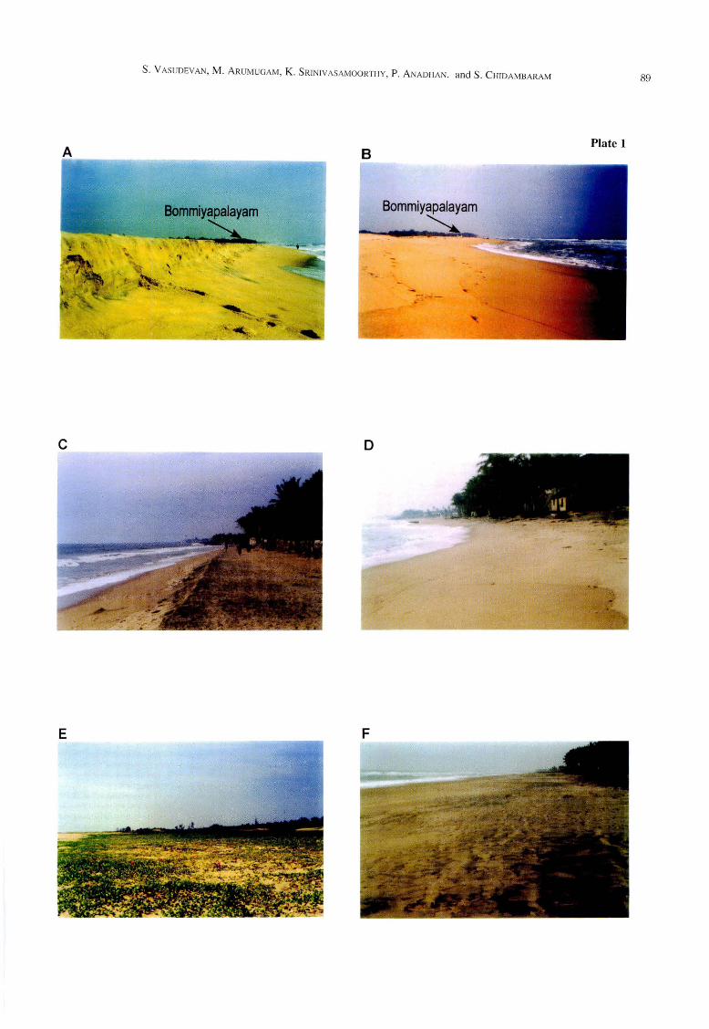
without any morphological features (Plate I, Figs. A and
B). The pre- and post-tsunami photographs of
Kottakuppam beach (Plate 1, Figs. C and D) depicts the
erosive nature of tsunami wave by the amount of sediment
washed off from berm and the present sea waves,
occupying the pre-berm area. The uncovered coconut tree
roots at Kottakuppam region are also evidences of the
removal of sediments from the beach. By the action of
giant wave in Veerampattinam region, the Halodule and
Cymodocea (commonly grown over sands which
accumulate and binds the sand) had been removed and had
laid the sand bare (Plate 1, Figs. E and F). The rise and fall
of tides cause characteristic sedimentary structures
(Wunderlich, 1972). In Cuddalore, Silver beach displays
characteristic features of very shallow water, and features
associated with falling water level and intermittent sub
aerial emergence of sedimentation surface are found as
seen by swash mark, adhesion ripples, various foam marks,
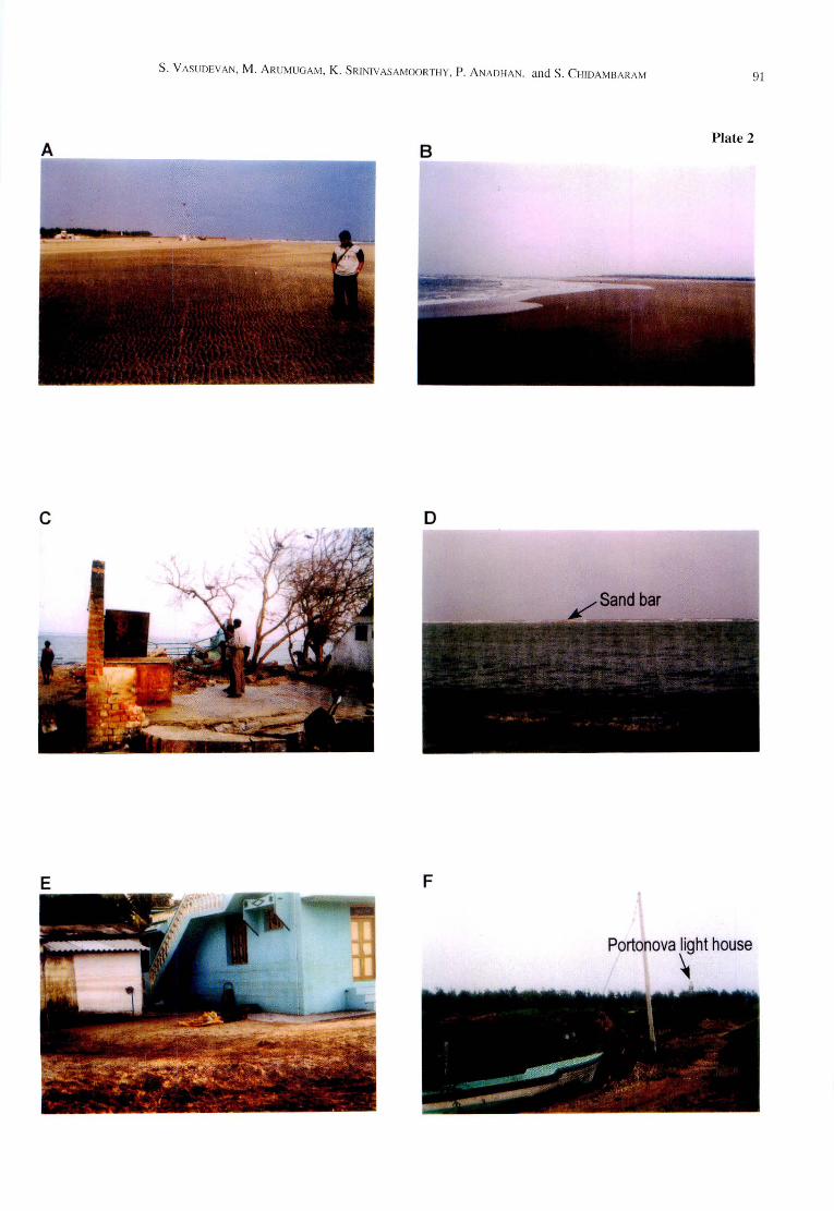
rill marks and flat topped ripple (Plate 2, Fig. A). Tsunami
has blown the beach slope and has made it more or less
flattened, causing sea water to invade considerable portions
of beach and also expanding its encroachment into the
beach during high tide (Plate 2, Fig. B). Demolished
concrete structures and ravaged homes (Plate 2, Fig. C)
also manifest the energy of tsunami wave.
In Portonova region, sand bar has been submerged
and advancement of shoreline over 30m has been noticed,
it is clearly evidenced by the wave action at submerged
sand bar region and at the present coast (Plate 2, Fig. D).
The water level evaporate markers (Plate 2, Fig. E) in the
houses, situated 250 m away from the coast at Pudupettai,
indicates the duration, stages of retreat and amount of
water expelled from sea. The ardour of the tsunami is also
displayed by boats dislodged between the coniferous trees
about 350 m away from the coast at Porto nova (Plate 2,
Fig. F).
The impact of tsunami over the type 2 beach
(Pondicherry to Cuddalore) was less when compared to
the type 1 (Cuddalore to Portonova). In the type 2 beach,
the features like cliffed coast, stony waste dumped along
the coastal regions of Pondicherry to reduce the wave
erosion, and the presence of estuaries like Gingee river,
Ariyankuppam river, Ponniyar, Gadilam and Uppanar
played significant role in reducing the impact of tsunami.
The northward location of the type 2 with respect to type I
led to reduction in the impact of tsunami. Even though
Cuddalore coast is the first affected portion in India, the
Gadilam estuary played a vital role to protect this region
from the impact of tsunami. The entire Silver beach (nearly
I km) served as the Gadilam river mouth and engulfed the
sea water as much as possible into its course. Had there
been no such river mouths in Cuddalore region, this region
should have been affected more and death toll might have
been greater than Nagapattinam. In the type 1 beach,
protective features like river mouth and cliffs etc. were
absent, causing this terrain more vulnerable to tsunami
action by its gentle slope without significant vegetative
cover other than Pichavaram mangrove forest in Portonova
region buffering the impact of tsunami. The impact of
tsunami was also comparatively high since it was
southward compared to the type 2. Combinations of these
factors led this region as worst affected one in between
PondichelTy and Portonova. The higher death tolls reported
coastal village is the Pudupettai in the type] beach of the
area of study.
6. Conclusions
On the basis of pre-tsunami scenario, the study area
has been divided in to northern erosional coastal segment
(which is retrograding-Pondicherry to Cuddalore) and,
southern depositional coastal segment (which is
prograding-Cuddalore to Portonova). Recent observations
made after tsunami effect indicate that the entire beach
have been disturbed and modified as a whole, rendering it
very flat and also losing its entity. This leads to the
inundation of coastline during high tide for considerable
distances. The adverse lesson learned from tsunami
emphasizes the necessity and the need for enforcing the
coastal regulation zone (CRZ) act. Coastal forest
development between the villages and CRZ along the
coastal region for a distance of 500 m will reduce the
energy of such natural damages. The immediate need for
India is to generate tsunami warning system and
communication facility and educating the people on the
methods of overcoming the effects of such natural disaster.
Acknowledgements
We are indebted to the editorial committee of the
journal for providing us an opportunity to publish this
paper. The manuscript benefited from review by Prof. W.
Maejima.
References
Gupta, H. K. (2005) A note on the 261h December 2004
Tsunami in the Indian Ocean. Jour. Geol. Soc. India,
65,247-248.
Johnson, B. D. (J 929) Shore Processes and Shoreline
Development. Wiley, New York, 584p.
Radakrishna, B. P. (2005) 0, horrible! Most horrible!
s. VASUDEVAN, M. ARUMUGAM, K. SRJNIVASAMOORTI-IY, P. ANADI-IAN. and S. CHJDAMBARAM
(Devastating tsunarni strikes coastline of India on 26th
December 2004). Jour. Geol. Soc. India, 65, 129-134.
Tsunami review meeting particulars 13.01.2005 (2005) of
Tamilnadu Government (unpublished), 5-6.
Wunderlich, F. (1972) Deposition of mud in the giant
ripples of inner Jade, German Bight, North Sea.
Senckenbergiana Marit. 10,257-267.
Manuscript received August 28, 2006.
Revised manuscript accepted December 2J, 2006.
87

88 Morphological Changes in the Beaches Caused by Tsunami, East Coast of India
Plate I.
Fig.A. Active cliff in Bommiyapalayam beach (pre-tsunami).
Fig.B. Cliff demolished by tsunami wave in BOnlmiyapalayam beach.
Fig.C. Beach in Kottakuppam (pre-tsunami).
Fig.D. Beach sand washed off by tsunami wave in Kottakuppam.
Fig.E. /pemoera in the beach sediments acts as sand binder in Veerampattinam (pre-tsunami).
Fig.F. /pemoera in the beach sediments are eroded by tsunami wave in Veerampattinam (pre-tsunami).
S. VASUDEVAN, M. ARUMUGAM, K. SRJNIVASAMOORTHY, P. ANADHAN. and S. CHIDAMBARAM 89
B
o
Plate 1

90 Morphological Changes in the Beaches Caused by Tsunami, East Coast ofJnclia
Plate 2.
Fig. A. Swash, rills and foam marks in Silver Beach of Cuddalore.
Fig. B. Beach slope modified into more or less flattened to cause sea water inundation to considerable
portion of Cuddalore beach.
Fig. C. Picture showing the remnants of a ravaged home at Portonova.
Fig. D. Sand bar disturbed by tsunami wave. Note the waves near the coast and also at submerged sand
bar.
Fig. E. Picture showing the water marks in home.
Fig. F. Tsunami wave thrown boats for several kilometers.
S. VASUDEVAN, M. ARUMUGAM, K. SRINIVASAMOORTHY, P. ANADHAN. and S. CHIDAMBARAM 91
BPlate 2
o
F
Portonova light house
~