Embed Size (px)
Citation preview
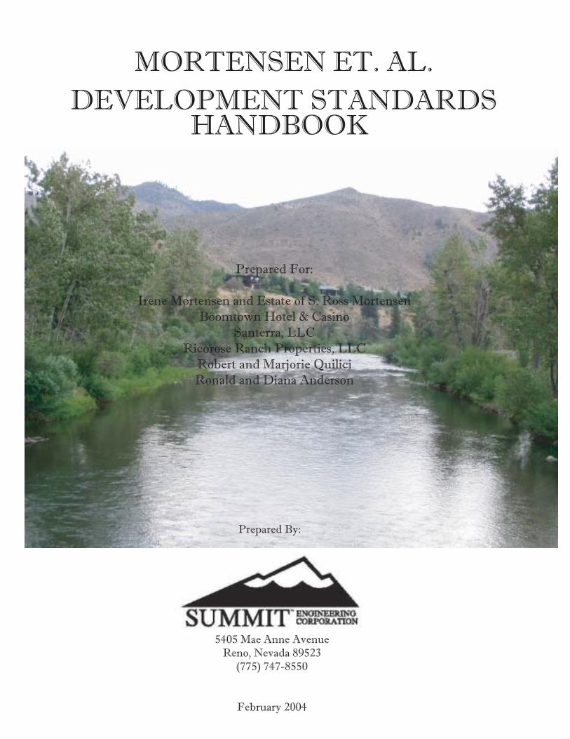
MORTENSEN ET. AL.
DEVELOPMENT STANDARDSHANDBOOK
Prepared For:
Irene Mortensen and Estate of S. Ross Mortensen
Boomtown Hotel & Casino
Santerra, LLC
Ricorose Ranch Properties, LLC
Robert and Marjorie Quilici
Ronald and Diana Anderson
Prepared By:
5405 Mae Anne Avenue
Reno, Nevada 89523
(775) 747-8550
February 2004
ContentsContentsContentsContentsContents
SSSSSECTIONECTIONECTIONECTIONECTION 1. P 1. P 1. P 1. P 1. PROJECTROJECTROJECTROJECTROJECT D D D D DESCRIPTIONESCRIPTIONESCRIPTIONESCRIPTIONESCRIPTION .............................................................................................................................................................................................................................................................................................1-11-11-11-11-1
1.1 LOCATION ............................................................................................................................................... 1-11.2 OWNERSHIP ............................................................................................................................................ 1-21.3 BACKGROUND ........................................................................................................................................ 1-21.4 ENTITLEMENT REQUESTS ........................................................................................................................ 1-5
SSSSSECTIONECTIONECTIONECTIONECTION 2. P 2. P 2. P 2. P 2. PHYSICALHYSICALHYSICALHYSICALHYSICAL C C C C CHARACTERISTICSHARACTERISTICSHARACTERISTICSHARACTERISTICSHARACTERISTICS .....................................................................................................................................................................................................................................................2-12-12-12-12-1
2.1 SURROUNDING LAND USE / DESIGNATIONS ...................................................................................... 2-12.2 EXISTING DEVELOPMENT PATTERN ....................................................................................................... 2-12.3 TOPOGRAPHY/SLOPES ............................................................................................................................ 2-62.4 WETLANDS ............................................................................................................................................. 2-9
SSSSSECTIONECTIONECTIONECTIONECTION 3. D 3. D 3. D 3. D 3. DEVELOPMENTEVELOPMENTEVELOPMENTEVELOPMENTEVELOPMENT P P P P PLANLANLANLANLAN ..................................................................................................................................................................................................................................................................................................3-13-13-13-13-1
3.1 LAND USE PLAN .................................................................................................................................... 3-13.2 TRAFFIC, CIRCULATION AND ACCESS .................................................................................................... 3-3 TRIP REDUCTION.............................................................................................................................................................. 3-73.3 WATER .................................................................................................................................................... 3-73.4 SEWER ..................................................................................................................................................... 3-93.5 PUBLIC SERVICES ...................................................................................................................................3-11 FIRE ............................................................................................................................................................................... 3-11 LAW ENFORCEMENT ................................................................................................................................................... 3-11 SEWER AND ROAD MAINTENANCE ........................................................................................................................... 3-11 FISCAL IMPACT .............................................................................................................................................................. 3-123.6 STORM WATER .....................................................................................................................................3-12
SSSSSECTIONECTIONECTIONECTIONECTION 4. D 4. D 4. D 4. D 4. DEVELOPMENTEVELOPMENTEVELOPMENTEVELOPMENTEVELOPMENT S S S S STANDARDSTANDARDSTANDARDSTANDARDSTANDARDS ................................................................................................................................................................................................................................................4-14-14-14-14-1
4.1 USES ........................................................................................................................................................ 4-14.2 HILLSIDE DEVELOPMENT........................................................................................................................ 4-1 PURPOSE .......................................................................................................................................................................... 4-1 APPLICABILITY .................................................................................................................................................................... 4-2 APPLICATION REQUIREMENTS AND PROCEDURES ......................................................................................................... 4-2 DETERMINATION OF DEVELOPABLE AREA ..................................................................................................................... 4-4 PROTECTED OPEN SPACE AREAS ................................................................................................................................... 4-5
SITE DEVELOPMENT STANDARDS .................................................................................................................................... 4-6 GRADING AND DRAINAGE STANDARDS ........................................................................................................................ 4-8 VEGETATION PRESERVATION AND RESTORATION STANDARDS ................................................................................... 4-9 STREET STANDARDS ...................................................................................................................................................... 4-10 FIRE SAFETY STANDARDS .............................................................................................................................................. 4-104.3 SIGNIFICANT HYDROLOGIC RESOURCES ..............................................................................................4-11 PURPOSE ....................................................................................................................................................................... 4-11 APPLICABILITY ................................................................................................................................................................ 4-12 PERENNIAL STREAMS BUFFER AREAS ......................................................................................................................... 4-14 CRITICAL STREAM ZONE BUFFER AREA DEVELOPMENT STANDARDS ...................................................................... 4-15 SENSITIVE STREAM ZONE BUFFER AREA DEVELOPMENT STANDARDS .................................................................... 4-17 SPECIAL REVIEW CONSIDERATIONS ............................................................................................................................ 4-19 MODIFICATION OF STANDARDS .................................................................................................................................. 4-194.4 RIDGELINES ............................................................................................................................................4-214.5 EDGE MATCHING ................................................................................................................................4-224.6 EXTERIOR LIGHTING ..............................................................................................................................4-22 LIGHT ............................................................................................................................................................................. 4-22 SHIELDING ...................................................................................................................................................................... 4-23 LIGHTING DESIGN ........................................................................................................................................................ 4-23 GLARE ............................................................................................................................................................................ 4-23 REDUCED LIGHTING LEVELS ........................................................................................................................................ 4-23 GENERAL LIGHTING STANDARDS ................................................................................................................................. 4-23 STREETLIGHTING ............................................................................................................................................................. 4-24 PEDESTRIAN LIGHTING .................................................................................................................................................. 4-24 RESIDENTIAL LIGHTING STANDARDS ............................................................................................................................ 4-24 COMMERCIAL LIGHTING STANDARDS .......................................................................................................................... 4-244.7 PARKS & TRAILS ....................................................................................................................................4-254.8 COMMUNITY DESIGN ...........................................................................................................................4-28 BUILDING HEIGHT ........................................................................................................................................................ 4-28 ACCESS .......................................................................................................................................................................... 4-28 GRADING ...................................................................................................................................................................... 4-29 FENCING (SEE ALSO PAGE 4-8, FENCES AND WALLS, OF THIS HANDBOOK) ...................................................... 4-30
SSSSSECTIONECTIONECTIONECTIONECTION 5. R 5. R 5. R 5. R 5. REGIONALEGIONALEGIONALEGIONALEGIONAL P P P P PLANLANLANLANLAN ..........................................................................................................................................................................................................................................................................................................................................5-15-15-15-15-1
SSSSSECTIONECTIONECTIONECTIONECTION 6. A 6. A 6. A 6. A 6. ADMINISTRATIONDMINISTRATIONDMINISTRATIONDMINISTRATIONDMINISTRATION / A / A / A / A / AMENDMENTSMENDMENTSMENDMENTSMENDMENTSMENDMENTS .........................................................................................................................................................................................6-16-16-16-16-1
6.1 ADMINISTRATION .................................................................................................................................... 6-16.2 AMENDMENTS ........................................................................................................................................ 6-16.3 SUBSEQUENT DEVELOPMENT APPLICATIONS ....................................................................................... 6-2
SSSSSECTIONECTIONECTIONECTIONECTION 7. A 7. A 7. A 7. A 7. APPENDICIESPPENDICIESPPENDICIESPPENDICIESPPENDICIES ...................................................................................................................................................................................................................................................................................................................................................................7-17-17-17-17-1
APPENDIX A. SETTLEMENT AGREEMENT ...................................................................................................... 7-2APPENDIX B. FISCAL IMPACT (YEAR TEN) .................................................................................................7-12APPENDIX C. DRAFT IMPLEMENTATION PLAN FOR GROUNDWATER RESOURCE DATA CENTER ...................
AND WELL MITIGATION PROGRAM...............................................................................7-13
BBBBBIBLIOGRAPHYIBLIOGRAPHYIBLIOGRAPHYIBLIOGRAPHYIBLIOGRAPHY ............................................................................................................................................................................................................................................................................................................................................................................................................................................................................B-1B-1B-1B-1B-1
Figures & TablesFigures & TablesFigures & TablesFigures & TablesFigures & Tables
SSSSSECTIONECTIONECTIONECTIONECTION 1. P 1. P 1. P 1. P 1. PROJECTROJECTROJECTROJECTROJECT D D D D DESCRIPTIONESCRIPTIONESCRIPTIONESCRIPTIONESCRIPTION .............................................................................................................................................................................................................................................................................................1-11-11-11-11-1
FFFFFIGUREIGUREIGUREIGUREIGURE 1-1 V 1-1 V 1-1 V 1-1 V 1-1 VICINITYICINITYICINITYICINITYICINITY M M M M MAPAPAPAPAP ......................................................................................................................................................................................................................................................................................................................................................................................................................................................................................................................................................................................................................................................................................................................................................................... 1-11-11-11-11-1TTTTTABLEABLEABLEABLEABLE 1-1 O 1-1 O 1-1 O 1-1 O 1-1 OWNERWNERWNERWNERWNER/P/P/P/P/PARCELARCELARCELARCELARCEL D D D D DATAATAATAATAATA ................................................................................................................................................................................................................................................................................................................................................................................................................................................................................................................................................................................................................................................................................................... 1-21-21-21-21-2
SSSSSECTIONECTIONECTIONECTIONECTION 2. P 2. P 2. P 2. P 2. PHYSICALHYSICALHYSICALHYSICALHYSICAL C C C C CHARACTERISTICSHARACTERISTICSHARACTERISTICSHARACTERISTICSHARACTERISTICS .....................................................................................................................................................................................................................................................2-12-12-12-12-1
FFFFFIGUREIGUREIGUREIGUREIGURE 2-1 E 2-1 E 2-1 E 2-1 E 2-1 EXISTINGXISTINGXISTINGXISTINGXISTING H H H H HOTELOTELOTELOTELOTEL ANDANDANDANDAND C C C C CASINOASINOASINOASINOASINO D D D D DEVELOPMENTSEVELOPMENTSEVELOPMENTSEVELOPMENTSEVELOPMENTS INININININ V V V V VERDIERDIERDIERDIERDI ....................................................................................................................................................................................................................................................................................................................................................................................... 2-22-22-22-22-2FFFFFIGUREIGUREIGUREIGUREIGURE 2-2 E 2-2 E 2-2 E 2-2 E 2-2 EXISTINGXISTINGXISTINGXISTINGXISTING I I I I INDUSTRIALNDUSTRIALNDUSTRIALNDUSTRIALNDUSTRIAL D D D D DEVELOPMENTSEVELOPMENTSEVELOPMENTSEVELOPMENTSEVELOPMENTS INININININ V V V V VERDIERDIERDIERDIERDI ....................................................................................................................................................................................................................................................................................................................................................................................................................................................................... 2-32-32-32-32-3FFFFFIGUREIGUREIGUREIGUREIGURE 2-3 E 2-3 E 2-3 E 2-3 E 2-3 EXISTINGXISTINGXISTINGXISTINGXISTING C C C C COMMERCIALOMMERCIALOMMERCIALOMMERCIALOMMERCIAL D D D D DEVELOPMENTSEVELOPMENTSEVELOPMENTSEVELOPMENTSEVELOPMENTS INININININ V V V V VERDIERDIERDIERDIERDI ........................................................................................................................................................................................................................................................................................................................................................................................................................................................ 2-42-42-42-42-4FFFFFIGUREIGUREIGUREIGUREIGURE 2-4 E 2-4 E 2-4 E 2-4 E 2-4 EXISTINGXISTINGXISTINGXISTINGXISTING R R R R RESIDENTIALESIDENTIALESIDENTIALESIDENTIALESIDENTIAL D D D D DEVELOPMENTSEVELOPMENTSEVELOPMENTSEVELOPMENTSEVELOPMENTS INININININ V V V V VERDIERDIERDIERDIERDI .................................................................................................................................................................................................................................................................................................................................................................................................................................................................. 2-52-52-52-52-5FFFFFIGUREIGUREIGUREIGUREIGURE 2-5 T 2-5 T 2-5 T 2-5 T 2-5 TOPOGRAPHICOPOGRAPHICOPOGRAPHICOPOGRAPHICOPOGRAPHIC M M M M MAPAPAPAPAP ........................................................................................................................................................................................................................................................................................................................................................................................................................................................................................................................................................................................................................................................................................................ 2-72-72-72-72-7FFFFFIGUREIGUREIGUREIGUREIGURE 2-6 S 2-6 S 2-6 S 2-6 S 2-6 SLOPELOPELOPELOPELOPE M M M M MAPAPAPAPAP ......................................................................................................................................................................................................................................................................................................................................................................................................................................................................................................................................................................................................................................................................................................................................................................... 2-82-82-82-82-8FFFFFIGUREIGUREIGUREIGUREIGURE 2-7 W 2-7 W 2-7 W 2-7 W 2-7 WETLANDSETLANDSETLANDSETLANDSETLANDS M M M M MAPAPAPAPAP .................................................................................................................................................................................................................................................................................................................................................................................................................................................................................................................................................................................................................................................................................................................. 2-102-102-102-102-10
SSSSSECTIONECTIONECTIONECTIONECTION 3. D 3. D 3. D 3. D 3. DEVELOPMENTEVELOPMENTEVELOPMENTEVELOPMENTEVELOPMENT P P P P PLANLANLANLANLAN ..................................................................................................................................................................................................................................................................................................3-13-13-13-13-1
TTTTTABLEABLEABLEABLEABLE 3-1 D 3-1 D 3-1 D 3-1 D 3-1 DEVELOPMENTEVELOPMENTEVELOPMENTEVELOPMENTEVELOPMENT P P P P POTENTIALOTENTIALOTENTIALOTENTIALOTENTIAL B B B B BYYYYY P P P P PROPERTYROPERTYROPERTYROPERTYROPERTY O O O O OWNERWNERWNERWNERWNER .................................................................................................................................................................................................................................................................................................................................................................................................................................................................. 3-13-13-13-13-1FFFFFIGUREIGUREIGUREIGUREIGURE 3-1 L 3-1 L 3-1 L 3-1 L 3-1 LANDANDANDANDAND U U U U USESESESESE P P P P PLANLANLANLANLAN ........................................................................................................................................................................................................................................................................................................................................................................................................................................................................................................................................................................................................................................................................................................................................... 3-23-23-23-23-2TTTTTABLEABLEABLEABLEABLE 3-2 D 3-2 D 3-2 D 3-2 D 3-2 DEVELOPMENTEVELOPMENTEVELOPMENTEVELOPMENTEVELOPMENT P P P P POTENTIALOTENTIALOTENTIALOTENTIALOTENTIAL B B B B BYYYYY L L L L LANDANDANDANDAND U U U U USESESESESE D D D D DESIGNATIONESIGNATIONESIGNATIONESIGNATIONESIGNATION ...................................................................................................................................................................................................................................................................................................................................................................................................... 3-33-33-33-33-3TTTTTABLEABLEABLEABLEABLE 3-3 R 3-3 R 3-3 R 3-3 R 3-3 RESIDENTIALESIDENTIALESIDENTIALESIDENTIALESIDENTIAL D D D D DEVELOPMENTEVELOPMENTEVELOPMENTEVELOPMENTEVELOPMENT P P P P POTENTIALOTENTIALOTENTIALOTENTIALOTENTIAL B B B B BYYYYY P P P P PLANNINGLANNINGLANNINGLANNINGLANNING A A A A AREAREAREAREAREA ................................................................................................................................................................................................................................................................................................................................................................... 3-33-33-33-33-3FFFFFIGUREIGUREIGUREIGUREIGURE 3-2 C 3-2 C 3-2 C 3-2 C 3-2 CIRCULATIONIRCULATIONIRCULATIONIRCULATIONIRCULATION P P P P PLANLANLANLANLAN ....................................................................................................................................................................................................................................................................................................................................................................................................................................................................................................................................................................................................................................................................................................................... 3-43-43-43-43-4FFFFFIGUREIGUREIGUREIGUREIGURE 3-3 P 3-3 P 3-3 P 3-3 P 3-3 PUBLICUBLICUBLICUBLICUBLIC F F F F FACILITIESACILITIESACILITIESACILITIESACILITIES ....................................................................................................................................................................................................................................................................................................................................................................................................................................................................................................................................................................................................................................................................................................................... 3-103-103-103-103-10
SSSSSECTIONECTIONECTIONECTIONECTION 4. D 4. D 4. D 4. D 4. DEVELOPMENTEVELOPMENTEVELOPMENTEVELOPMENTEVELOPMENT S S S S STANDARDSTANDARDSTANDARDSTANDARDSTANDARDS ................................................................................................................................................................................................................................................4-14-14-14-14-1
FFFFFIGUREIGUREIGUREIGUREIGURE 4-1 S 4-1 S 4-1 S 4-1 S 4-1 SIGNIFICANTIGNIFICANTIGNIFICANTIGNIFICANTIGNIFICANT H H H H HYDROLOGICYDROLOGICYDROLOGICYDROLOGICYDROLOGIC R R R R RESOURCESESOURCESESOURCESESOURCESESOURCES ................................................................................................................................................................................................................................................................................................................................................................................................................................................................................................................................... 4-134-134-134-134-13FFFFFIGUREIGUREIGUREIGUREIGURE 4-2 R 4-2 R 4-2 R 4-2 R 4-2 RIDGELINESIDGELINESIDGELINESIDGELINESIDGELINES ............................................................................................................................................................................................................................................................................................................................................................................................................................................................................................................................................................................................................................................................................................................................................................... 4-214-214-214-214-21FFFFFIGUREIGUREIGUREIGUREIGURE 4-3 P 4-3 P 4-3 P 4-3 P 4-3 PARKSARKSARKSARKSARKS ANDANDANDANDAND T T T T TRAILSRAILSRAILSRAILSRAILS P P P P PLANLANLANLANLAN ...................................................................................................................................................................................................................................................................................................................................................................................................................................................................................................................................................................................................................................................... 4-264-264-264-264-26FFFFFIGUREIGUREIGUREIGUREIGURE 4-4 B 4-4 B 4-4 B 4-4 B 4-4 BUILDINGUILDINGUILDINGUILDINGUILDING H H H H HEIGHTSEIGHTSEIGHTSEIGHTSEIGHTS ........................................................................................................................................................................................................................................................................................................................................................................................................................................................................................................................................................................................................................................................................................................ 4-284-284-284-284-28FFFFFIGUREIGUREIGUREIGUREIGURE 4-5 T 4-5 T 4-5 T 4-5 T 4-5 TYPICALYPICALYPICALYPICALYPICAL S S S S SETBACKETBACKETBACKETBACKETBACK ATATATATAT E E E E EXISTINGXISTINGXISTINGXISTINGXISTING R R R R RESIDENCEESIDENCEESIDENCEESIDENCEESIDENCE .......................................................................................................................................................................................................................................................................................................................................................................................................................................................................................................... 4-294-294-294-294-29
PPPPPRRRRROJECTOJECTOJECTOJECTOJECT D D D D DESCRIPTIONESCRIPTIONESCRIPTIONESCRIPTIONESCRIPTION
MMMMMORORORORORTENSENTENSENTENSENTENSENTENSEN D D D D DEVELEVELEVELEVELEVELOPMENTOPMENTOPMENTOPMENTOPMENT S S S S STTTTTANDANDANDANDANDARDSARDSARDSARDSARDS H H H H HANDBOOKANDBOOKANDBOOKANDBOOKANDBOOK C C C C CITYITYITYITYITY OFOFOFOFOF R R R R RENOENOENOENOENO
JJJJJANUARANUARANUARANUARANUARYYYYY 2004 2004 2004 2004 2004 1-1 1-1 1-1 1-1 1-1
SSSSSECTIONECTIONECTIONECTIONECTION 1. P 1. P 1. P 1. P 1. PRRRRROJECTOJECTOJECTOJECTOJECT D D D D DESCRIPTIONESCRIPTIONESCRIPTIONESCRIPTIONESCRIPTION
1.1 LOCATION
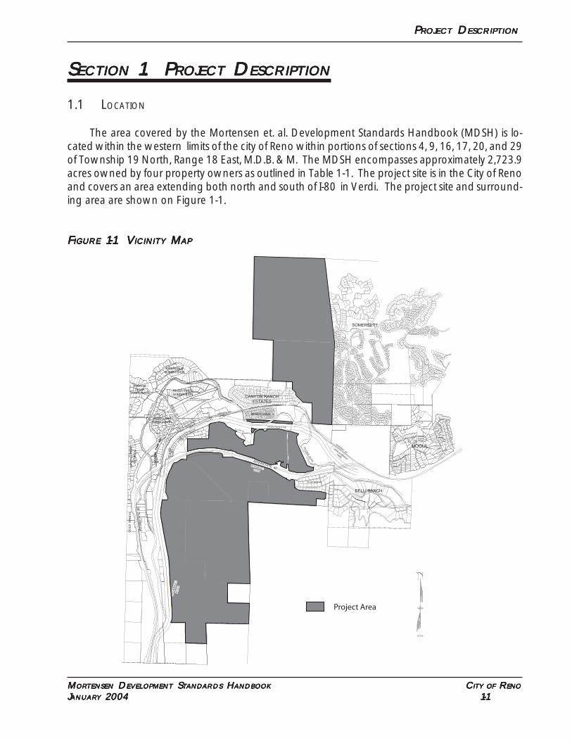
The area covered by the Mortensen et. al. Development Standards Handbook (MDSH) is lo-cated within the western limits of the city of Reno within portions of sections 4, 9, 16, 17, 20, and 29of Township 19 North, Range 18 East, M.D.B. & M. The MDSH encompasses approximately 2,723.9acres owned by four property owners as outlined in Table 1-1. The project site is in the City of Renoand covers an area extending both north and south of I-80 in Verdi. The project site and surround-ing area are shown on Figure 1-1.
FFFFFIGUREIGUREIGUREIGUREIGURE 1-1 V 1-1 V 1-1 V 1-1 V 1-1 VICINITYICINITYICINITYICINITYICINITY M M M M MAPAPAPAPAP
CR
YS
TA
LPA
RK
R
D.
GA
RS
ON
RD
.
MORTENSEN
BOOMTOWN
BOOMTOWN
BOOMTOWN
BO
OM
TO
WN
BOOMTOWN
UNION PACIFIC RR
MOGUL
STEAMBOAT
ST
EA
MB
OA
TD
ITC
H
DITCH
HIGHWAY 40
INTERSTATE 80
HIG
HW
AY 40
TR
UC
KE
E R
IVE
R
TR
UC
KE
E R
IVE
R
CANYON RANCH
ESTATES
SO. VERDI RD.
INT
ER
ST
AT
E 80
BLUE HERON
BELLI RANCH
N.T.S.
RIVER OAKS
VER
DI B
USIN
ESS
PAR
K
GO
LD
R
AN
CH
SOMERSETT
,
314
6251
0.00
20
87
18 17 8
20
32
5
8
4
9
RIVERDALE
SUBDIVISION
SUNRISE
CREEK
SUBDIVISIONRIVER PINES
SUBDIVISION
VERDI LAKE
SUBDIVISION
CR
YS
TA
L P
EA
K
ES
TA
TE
S
BR
IDG
E S
T.
Project Area
PPPPPRRRRROJECTOJECTOJECTOJECTOJECT D D D D DESCRIPTIONESCRIPTIONESCRIPTIONESCRIPTIONESCRIPTION
MMMMMORORORORORTENSENTENSENTENSENTENSENTENSEN D D D D DEVELEVELEVELEVELEVELOPMENTOPMENTOPMENTOPMENTOPMENT S S S S STTTTTANDANDANDANDANDARDSARDSARDSARDSARDS H H H H HANDBOOKANDBOOKANDBOOKANDBOOKANDBOOK C C C C CITYITYITYITYITY OFOFOFOFOF R R R R RENOENOENOENOENO
JJJJJANUARANUARANUARANUARANUARYYYYY 2004 2004 2004 2004 2004 1-2 1-2 1-2 1-2 1-2
1.2 OWNERSHIP
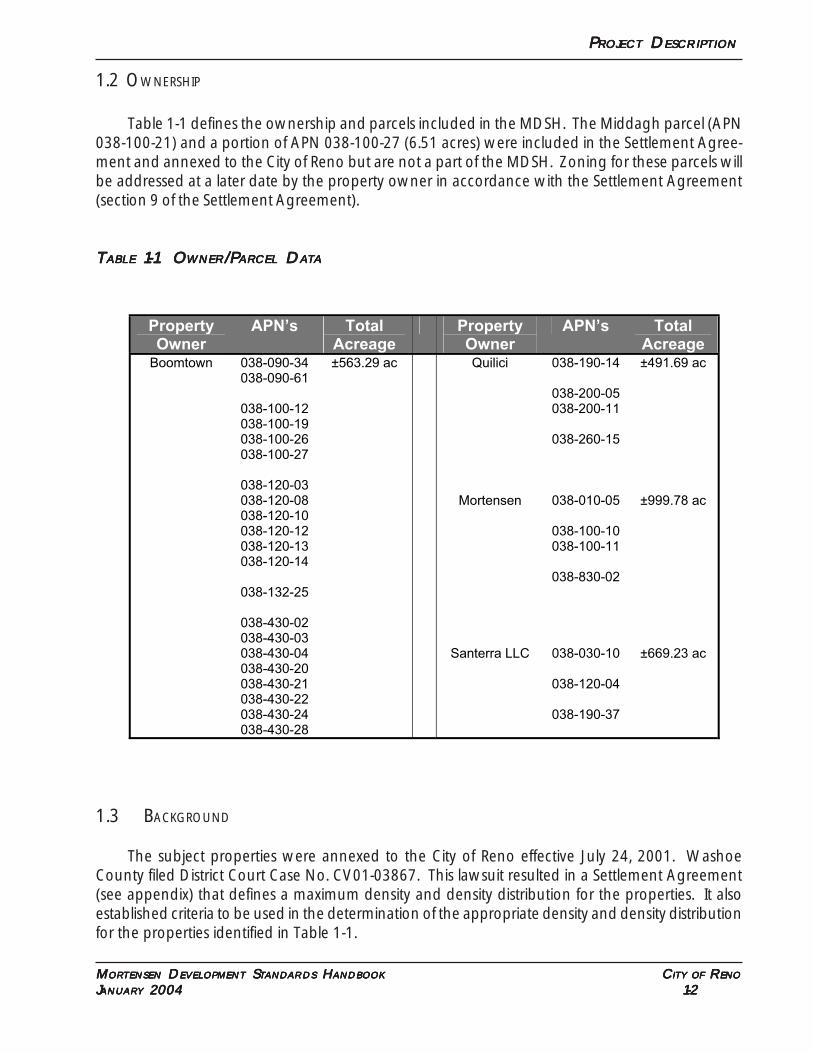
Table 1-1 defines the ownership and parcels included in the MDSH. The Middagh parcel (APN038-100-21) and a portion of APN 038-100-27 (6.51 acres) were included in the Settlement Agree-ment and annexed to the City of Reno but are not a part of the MDSH. Zoning for these parcels willbe addressed at a later date by the property owner in accordance with the Settlement Agreement(section 9 of the Settlement Agreement).
TTTTTABLEABLEABLEABLEABLE 1-1 O 1-1 O 1-1 O 1-1 O 1-1 OWNERWNERWNERWNERWNER/P/P/P/P/PARARARARARCELCELCELCELCEL D D D D DAAAAATTTTTAAAAA
Property Owner
APN’s Total Acreage
Property Owner
APN’s Total Acreage
Boomtown
038-090-34 038-090-61
038-100-12 038-100-19 038-100-26 038-100-27
038-120-03 038-120-08 038-120-10 038-120-12 038-120-13 038-120-14
038-132-25
038-430-02 038-430-03 038-430-04 038-430-20 038-430-21 038-430-22 038-430-24 038-430-28
±563.29 ac Quilici
Mortensen
Santerra LLC
038-190-14
038-200-05 038-200-11
038-260-15
038-010-05
038-100-10 038-100-11
038-830-02
038-030-10
038-120-04
038-190-37
±491.69 ac
±999.78 ac
±669.23 ac
1.3 BACKGROUND
The subject properties were annexed to the City of Reno effective July 24, 2001. WashoeCounty filed District Court Case No. CV01-03867. This lawsuit resulted in a Settlement Agreement(see appendix) that defines a maximum density and density distribution for the properties. It alsoestablished criteria to be used in the determination of the appropriate density and density distributionfor the properties identified in Table 1-1.
PPPPPRRRRROJECTOJECTOJECTOJECTOJECT D D D D DESCRIPTIONESCRIPTIONESCRIPTIONESCRIPTIONESCRIPTION
MMMMMORORORORORTENSENTENSENTENSENTENSENTENSEN D D D D DEVELEVELEVELEVELEVELOPMENTOPMENTOPMENTOPMENTOPMENT S S S S STTTTTANDANDANDANDANDARDSARDSARDSARDSARDS H H H H HANDBOOKANDBOOKANDBOOKANDBOOKANDBOOK C C C C CITYITYITYITYITY OFOFOFOFOF R R R R RENOENOENOENOENO
JJJJJANUARANUARANUARANUARANUARYYYYY 2004 2004 2004 2004 2004 1-3 1-3 1-3 1-3 1-3
The maximum density allowed by the Settlement Agreement is defined as:
• Existing 124 acres of commercial along the I-80 corridor;
• Up to an additional 176 acres of commercial along the I-80 corridor or railroad track; and
• Up to 3,000 residential units, including non-residential equivalents, on the remainder of theproperties which limitation does not include the 124 acres and 176 acres noted above.
In addition to defining the maximum density that is permissible, the Settlement Agreement setout criteria to be used in preparing a land plan for the properties. These criteria include:
• Any natural constraints in slopes and wetlands
• The ability to obtain sewer and wastewater service and the likelihood that said service will bein place at certificate of occupancy or final inspection
• The availability of water resources and water delivery systems and the likelihood that saidservice and system will be in place at certificate of occupancy or final inspection
• Any impacts of traffic, level of service and level of congestion on the existing Verdi community
• The delivery of services, including fire, law enforcement, water, sewer and road maintenance,and how the provision of services affects, if at all, existing and neighboring communities
• The impact of future development in the requested densities on adjacent communities
• The requirements of Policy 1.2.16 of the 2002 Regional Plan unless inconsistent with theforegoing.
Policy 1.2.16 of the 2002 Truckee Meadows Regional Plan reads as follows:
“The Regional Plan designates the following general areas for emerging employ-“The Regional Plan designates the following general areas for emerging employ-“The Regional Plan designates the following general areas for emerging employ-“The Regional Plan designates the following general areas for emerging employ-“The Regional Plan designates the following general areas for emerging employ-ment centers: the southeast Truckee Meadows, Stead, east and north Sparks, the Patrickment centers: the southeast Truckee Meadows, Stead, east and north Sparks, the Patrickment centers: the southeast Truckee Meadows, Stead, east and north Sparks, the Patrickment centers: the southeast Truckee Meadows, Stead, east and north Sparks, the Patrickment centers: the southeast Truckee Meadows, Stead, east and north Sparks, the Patrickinterchange of the east Truckee River Canyon, and the Boomtown area.interchange of the east Truckee River Canyon, and the Boomtown area.interchange of the east Truckee River Canyon, and the Boomtown area.interchange of the east Truckee River Canyon, and the Boomtown area.interchange of the east Truckee River Canyon, and the Boomtown area.
To conform with the Regional Plan, Local Government and Affected Entity MasterTo conform with the Regional Plan, Local Government and Affected Entity MasterTo conform with the Regional Plan, Local Government and Affected Entity MasterTo conform with the Regional Plan, Local Government and Affected Entity MasterTo conform with the Regional Plan, Local Government and Affected Entity MasterPlans must maintain and improve the viability of these areas as major employmentPlans must maintain and improve the viability of these areas as major employmentPlans must maintain and improve the viability of these areas as major employmentPlans must maintain and improve the viability of these areas as major employmentPlans must maintain and improve the viability of these areas as major employmentcenters with the following master plan provisions:centers with the following master plan provisions:centers with the following master plan provisions:centers with the following master plan provisions:centers with the following master plan provisions:
1) Provide adequate non-residential land supply;1) Provide adequate non-residential land supply;1) Provide adequate non-residential land supply;1) Provide adequate non-residential land supply;1) Provide adequate non-residential land supply;2) Provide convenient access to major roads and/or freeways;2) Provide convenient access to major roads and/or freeways;2) Provide convenient access to major roads and/or freeways;2) Provide convenient access to major roads and/or freeways;2) Provide convenient access to major roads and/or freeways;3) Require pedestrian connections throughout the areas and to nearby residen-3) Require pedestrian connections throughout the areas and to nearby residen-3) Require pedestrian connections throughout the areas and to nearby residen-3) Require pedestrian connections throughout the areas and to nearby residen-3) Require pedestrian connections throughout the areas and to nearby residen-
tial areas; tial areas; tial areas; tial areas; tial areas;
PPPPPRRRRROJECTOJECTOJECTOJECTOJECT D D D D DESCRIPTIONESCRIPTIONESCRIPTIONESCRIPTIONESCRIPTION
MMMMMORORORORORTENSENTENSENTENSENTENSENTENSEN D D D D DEVELEVELEVELEVELEVELOPMENTOPMENTOPMENTOPMENTOPMENT S S S S STTTTTANDANDANDANDANDARDSARDSARDSARDSARDS H H H H HANDBOOKANDBOOKANDBOOKANDBOOKANDBOOK C C C C CITYITYITYITYITY OFOFOFOFOF R R R R RENOENOENOENOENO
JJJJJANUARANUARANUARANUARANUARYYYYY 2004 2004 2004 2004 2004 1-4 1-4 1-4 1-4 1-4
4) Plan for transit service;4) Plan for transit service;4) Plan for transit service;4) Plan for transit service;4) Plan for transit service;5) Provide adequate residential land supply in the surrounding area to house the5) Provide adequate residential land supply in the surrounding area to house the5) Provide adequate residential land supply in the surrounding area to house the5) Provide adequate residential land supply in the surrounding area to house the5) Provide adequate residential land supply in the surrounding area to house the
anticipated number of employees; anticipated number of employees; anticipated number of employees; anticipated number of employees; anticipated number of employees;6) Require design and intensity standards to maintain the character of nearby6) Require design and intensity standards to maintain the character of nearby6) Require design and intensity standards to maintain the character of nearby6) Require design and intensity standards to maintain the character of nearby6) Require design and intensity standards to maintain the character of nearby
residential areas; and, residential areas; and, residential areas; and, residential areas; and, residential areas; and,7) Promote reverse commute and trip reduction strategies.”7) Promote reverse commute and trip reduction strategies.”7) Promote reverse commute and trip reduction strategies.”7) Promote reverse commute and trip reduction strategies.”7) Promote reverse commute and trip reduction strategies.”
Specific subject matters to be included in the development standards handbook were also iden-tified. These are:
• Hillside development standards consistent with WCDC 110.424 as of the date of the settle-ment agreement;
• Hydrologic resources standards consistent with WCDC 110.418 as of the date of the settle-ment agreement;
• Edge matching in a manner that new development adjacent to the existing developments ofBlue Heron, Verdi Bluffs and Canyon Ranch Estates subdivisions provides and edge densityand lot size for edge lots equal to or less dense than the above-referenced subdivisions, orprovides an open space buffer equal to at least one lot depth of the above-referenced subdi-visions. This standard in no event requires an edge lot size or buffer in excess of 1 acre in size;
• Exterior lighting standards or design features to serve the needs of development but in amanner to minimize illumination of the night skies for the rest of the Verdi community;
• A traffic design, both interior and exterior to any development, minimizing traffic impacts onthe rest of the Verdi community;
• A storm water and flood control management plan ;
• Community design standards to complement the character of the rest of the Verdi commu-nity;
• Procedures and criteria to amend the DSH; and,
• Except as provided in paragraph 9 amendments to the DSH not inconsistent with this agree-ment will not be subject to cooperative planning.
PPPPPRRRRROJECTOJECTOJECTOJECTOJECT D D D D DESCRIPTIONESCRIPTIONESCRIPTIONESCRIPTIONESCRIPTION
MMMMMORORORORORTENSENTENSENTENSENTENSENTENSEN D D D D DEVELEVELEVELEVELEVELOPMENTOPMENTOPMENTOPMENTOPMENT S S S S STTTTTANDANDANDANDANDARDSARDSARDSARDSARDS H H H H HANDBOOKANDBOOKANDBOOKANDBOOKANDBOOK C C C C CITYITYITYITYITY OFOFOFOFOF R R R R RENOENOENOENOENO
JJJJJANUARANUARANUARANUARANUARYYYYY 2004 2004 2004 2004 2004 1-5 1-5 1-5 1-5 1-5
1.4 ENTITLEMENT REQUESTS
The subject properties are currently zoned HC (Hotel/Casino) and SPD (Specific Plan District).The existing SPD designation has no details on land use densities or design standards. The MDSHincludes an application for a Zoning Map Amendment to create standard city zoning category desig-nations for the property and Text Amendment to establish an overlay zone to create developmentstandards applicable to the properties as contemplated in the Settlement Agreement.
It is envisioned that the MDSH will be the development standards applicable to the propertiesand be adopted by reference as a part of Reno Municipal Code (Overlay Districts). Reno MunicipalCode will apply where matters are not specifically addressed by the MDSH. In the event of a conflictbetween the MDSH and Reno Municipal Code, the MDSH shall apply. Updates to the RMC as mayoccur over the life of the development of the property shall apply only to the extent that they do notconflict with the MDSH or serve to deny the development of the properties as envisioned in theMDSH.
P P P P PHYSICALHYSICALHYSICALHYSICALHYSICAL C C C C CHARACTERISTICSHARACTERISTICSHARACTERISTICSHARACTERISTICSHARACTERISTICS
MMMMMORORORORORTENSENTENSENTENSENTENSENTENSEN D D D D DEVELEVELEVELEVELEVELOPMENTOPMENTOPMENTOPMENTOPMENT S S S S STTTTTANDANDANDANDANDARDSARDSARDSARDSARDS H H H H HANDBOOKANDBOOKANDBOOKANDBOOKANDBOOK C C C C CITYITYITYITYITY OFOFOFOFOF R R R R RENOENOENOENOENO
JJJJJANUARANUARANUARANUARANUARYYYYY 2004 2004 2004 2004 2004 2-1 2-1 2-1 2-1 2-1
SSSSSECTIONECTIONECTIONECTIONECTION 2. P 2. P 2. P 2. P 2. PHYSICALHYSICALHYSICALHYSICALHYSICAL C C C C CHARAHARAHARAHARAHARACTERISTICSCTERISTICSCTERISTICSCTERISTICSCTERISTICS
2.1 SURROUNDING LAND USE / DESIGNATIONS
To the north of the project area is undeveloped privately held land that has a land use designa-tion of General Rural (one dwelling unit per 40 acres). To the north of the Boomtown property is theRiver Oaks subdivision. This development, consisting of single family homes with lot sizes rangingfrom 3,600 to 8,400 square feet, is separated from Boomtown’s property by the Union Pacific Rail-road tracks and the Truckee River. This subdivision is designated Low Density Urban (10 dwellingunits per acre for single family and 14 dwelling units per acre for multi-family).
To the south of the project area is undeveloped U.S. Forest Service land designated Open Space.
The majority of the developed land adjacent to the project area lies to the east and west.
To the east of the project area is a combination of existing and planned residential land uses andan existing industrial park (i.e. Verdi Business Park). Immediately east and abutting the Mortensenproperty is the planned Somersett Development consisting of an Active Adult Retirement Communitywith lots less than 6,000 square feet in size and one acre custom lots with a PUD (Planned UnitDevelopment) zoning designation. The southeast boundary of the Mortensen property is adjacentto vacant land that has been annexed to the City of Reno and has a zoning of LLR-1 (one dwellingunite per acre). East of the southern Boomtown holdings is the Blue Heron subdivision. This subdi-vision has a land use designation of LDS (one dwelling unit per acre) and is developed with singlefamily homes on lots ranging in size from 0.96 to 1.6 acres.
To the west of the project area are existing and planned residential subdivisions. Adjacent to thesouthwest portion of the Mortensen property is the planned Canyon Ranch Estates subdivision. Thisdevelopment is zoned LLR-1 (one acre) and SF15 (15,000 square feet) and is in the City of Reno. It isplanned for single family lots of approximately 0.5 acre in size. Immediately to the west of Boomtownproperty is the Verdi Bluff neighborhood. This area is designated LDS (one dwelling unit per acre)and developed with lots ranging from one acre to 1.6 acres in size. To the west of the Quilici Ranchis land designated Industrial and several existing dwelling units with land use designations of MDS(three dwelling units per acre) and GR (one dwelling unit per 40 acres). Across the railroad tracksand to the west of the proposed Business Park on the Quilici Ranch is an existing residence and four(4) vacant two and one-half (2.5) acre lots. This property is owned by one of the applicants (i.e.Quilici).
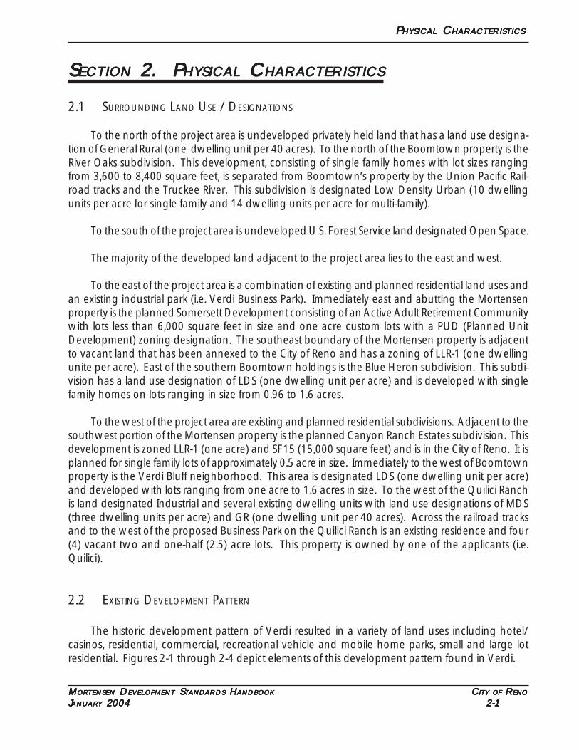
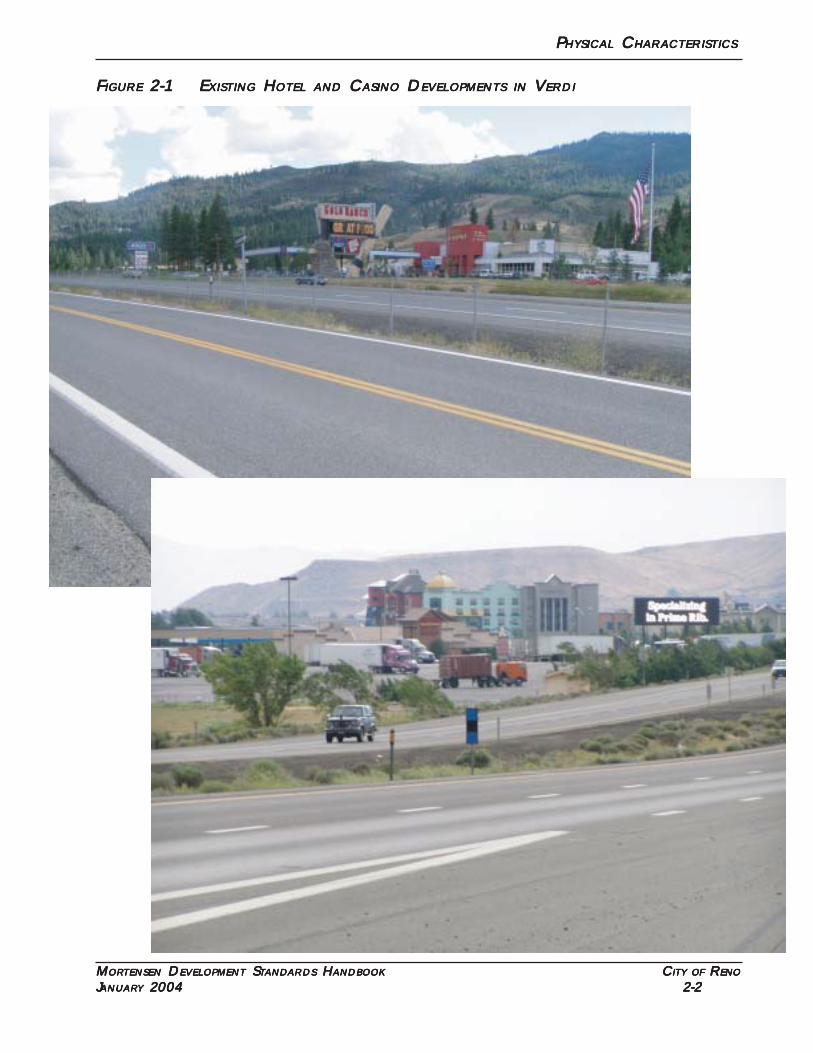
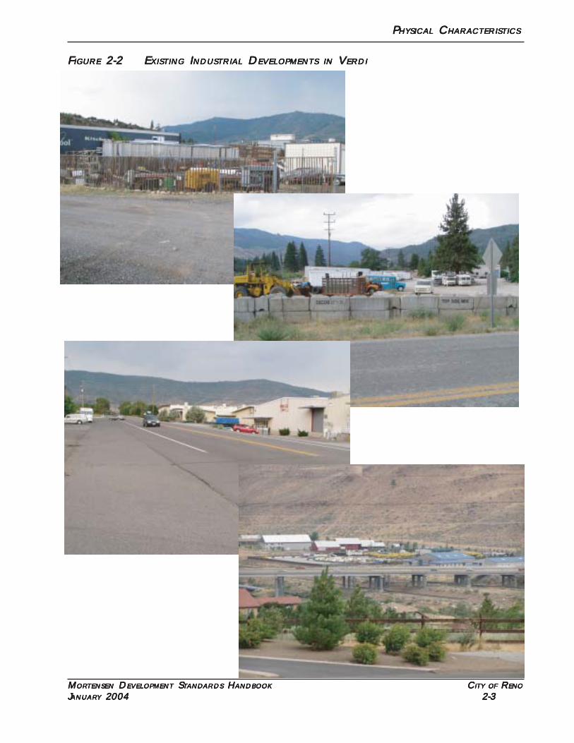
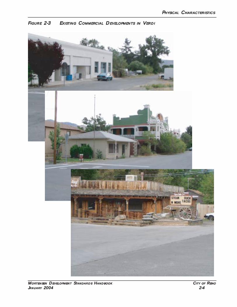
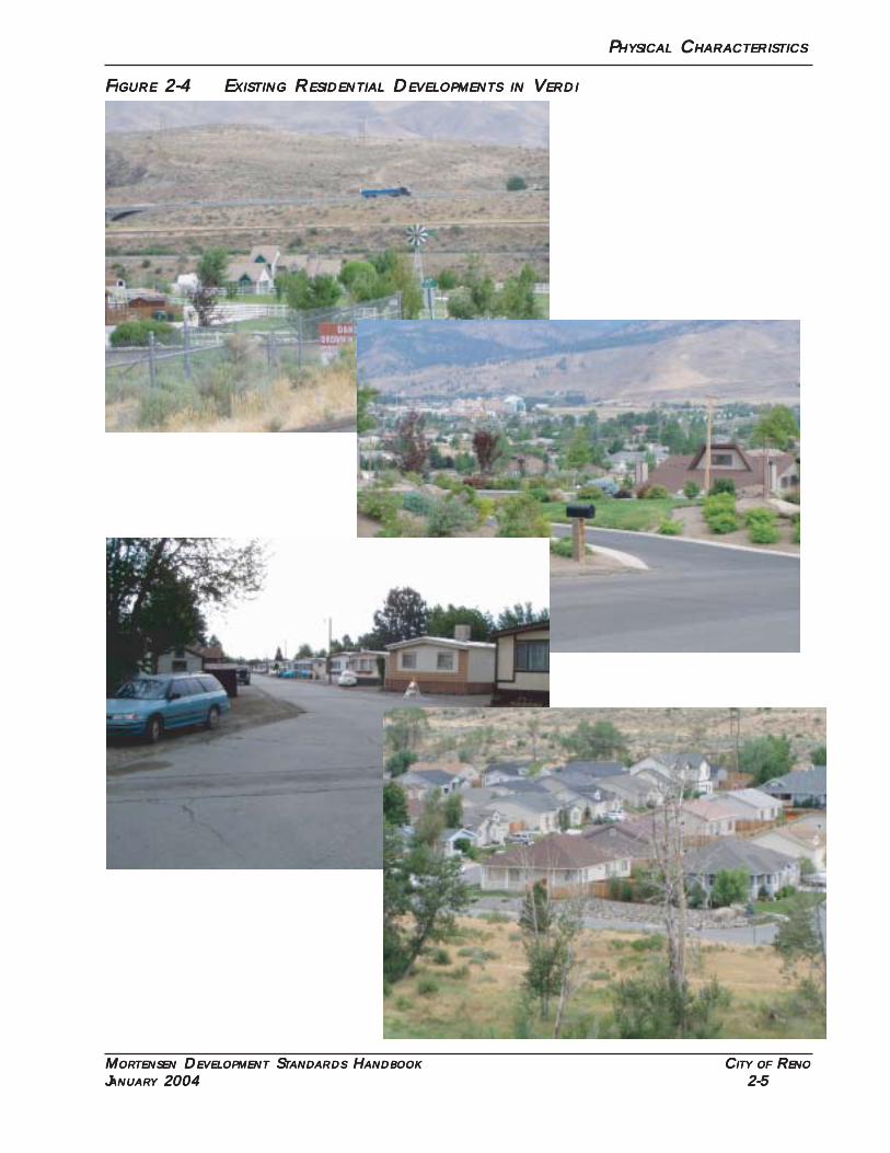
2.2 EXISTING DEVELOPMENT PATTERN
The historic development pattern of Verdi resulted in a variety of land uses including hotel/casinos, residential, commercial, recreational vehicle and mobile home parks, small and large lotresidential. Figures 2-1 through 2-4 depict elements of this development pattern found in Verdi.
P P P P PHYSICALHYSICALHYSICALHYSICALHYSICAL C C C C CHARACTERISTICSHARACTERISTICSHARACTERISTICSHARACTERISTICSHARACTERISTICS
MMMMMORORORORORTENSENTENSENTENSENTENSENTENSEN D D D D DEVELEVELEVELEVELEVELOPMENTOPMENTOPMENTOPMENTOPMENT S S S S STTTTTANDANDANDANDANDARDSARDSARDSARDSARDS H H H H HANDBOOKANDBOOKANDBOOKANDBOOKANDBOOK C C C C CITYITYITYITYITY OFOFOFOFOF R R R R RENOENOENOENOENO
JJJJJANUARANUARANUARANUARANUARYYYYY 2004 2004 2004 2004 2004 2-2 2-2 2-2 2-2 2-2
FFFFFIGUREIGUREIGUREIGUREIGURE 2-1 E 2-1 E 2-1 E 2-1 E 2-1 EXISTINGXISTINGXISTINGXISTINGXISTING H H H H HOTELOTELOTELOTELOTEL ANDANDANDANDAND C C C C CASINOASINOASINOASINOASINO D D D D DEVELOPMENTSEVELOPMENTSEVELOPMENTSEVELOPMENTSEVELOPMENTS INININININ V V V V VERDIERDIERDIERDIERDI
P P P P PHYSICALHYSICALHYSICALHYSICALHYSICAL C C C C CHARACTERISTICSHARACTERISTICSHARACTERISTICSHARACTERISTICSHARACTERISTICS
MMMMMORORORORORTENSENTENSENTENSENTENSENTENSEN D D D D DEVELEVELEVELEVELEVELOPMENTOPMENTOPMENTOPMENTOPMENT S S S S STTTTTANDANDANDANDANDARDSARDSARDSARDSARDS H H H H HANDBOOKANDBOOKANDBOOKANDBOOKANDBOOK C C C C CITYITYITYITYITY OFOFOFOFOF R R R R RENOENOENOENOENO
JJJJJANUARANUARANUARANUARANUARYYYYY 2004 2004 2004 2004 2004 2-3 2-3 2-3 2-3 2-3
FFFFFIGUREIGUREIGUREIGUREIGURE 2-2 E 2-2 E 2-2 E 2-2 E 2-2 EXISTINGXISTINGXISTINGXISTINGXISTING I I I I INDUSTRIALNDUSTRIALNDUSTRIALNDUSTRIALNDUSTRIAL D D D D DEVELOPMENTSEVELOPMENTSEVELOPMENTSEVELOPMENTSEVELOPMENTS INININININ V V V V VERDIERDIERDIERDIERDI
P P P P PHYSICALHYSICALHYSICALHYSICALHYSICAL C C C C CHARACTERISTICSHARACTERISTICSHARACTERISTICSHARACTERISTICSHARACTERISTICS
MMMMMORORORORORTENSENTENSENTENSENTENSENTENSEN D D D D DEVELEVELEVELEVELEVELOPMENTOPMENTOPMENTOPMENTOPMENT S S S S STTTTTANDANDANDANDANDARDSARDSARDSARDSARDS H H H H HANDBOOKANDBOOKANDBOOKANDBOOKANDBOOK C C C C CITYITYITYITYITY OFOFOFOFOF R R R R RENOENOENOENOENO
JJJJJANUARANUARANUARANUARANUARYYYYY 2004 2004 2004 2004 2004 2-4 2-4 2-4 2-4 2-4
FFFFFIGUREIGUREIGUREIGUREIGURE 2-3 E 2-3 E 2-3 E 2-3 E 2-3 EXISTINGXISTINGXISTINGXISTINGXISTING C C C C COMMEROMMEROMMEROMMEROMMERCIALCIALCIALCIALCIAL D D D D DEVELEVELEVELEVELEVELOPMENTSOPMENTSOPMENTSOPMENTSOPMENTS INININININ V V V V VERDIERDIERDIERDIERDI
P P P P PHYSICALHYSICALHYSICALHYSICALHYSICAL C C C C CHARACTERISTICSHARACTERISTICSHARACTERISTICSHARACTERISTICSHARACTERISTICS
MMMMMORORORORORTENSENTENSENTENSENTENSENTENSEN D D D D DEVELEVELEVELEVELEVELOPMENTOPMENTOPMENTOPMENTOPMENT S S S S STTTTTANDANDANDANDANDARDSARDSARDSARDSARDS H H H H HANDBOOKANDBOOKANDBOOKANDBOOKANDBOOK C C C C CITYITYITYITYITY OFOFOFOFOF R R R R RENOENOENOENOENO
JJJJJANUARANUARANUARANUARANUARYYYYY 2004 2004 2004 2004 2004 2-5 2-5 2-5 2-5 2-5
FFFFFIGUREIGUREIGUREIGUREIGURE 2-4 E 2-4 E 2-4 E 2-4 E 2-4 EXISTINGXISTINGXISTINGXISTINGXISTING R R R R RESIDENTIALESIDENTIALESIDENTIALESIDENTIALESIDENTIAL D D D D DEVELOPMENTSEVELOPMENTSEVELOPMENTSEVELOPMENTSEVELOPMENTS INININININ V V V V VERDIERDIERDIERDIERDI
P P P P PHYSICALHYSICALHYSICALHYSICALHYSICAL C C C C CHARACTERISTICSHARACTERISTICSHARACTERISTICSHARACTERISTICSHARACTERISTICS
MMMMMORORORORORTENSENTENSENTENSENTENSENTENSEN D D D D DEVELEVELEVELEVELEVELOPMENTOPMENTOPMENTOPMENTOPMENT S S S S STTTTTANDANDANDANDANDARDSARDSARDSARDSARDS H H H H HANDBOOKANDBOOKANDBOOKANDBOOKANDBOOK C C C C CITYITYITYITYITY OFOFOFOFOF R R R R RENOENOENOENOENO
JJJJJANUARANUARANUARANUARANUARYYYYY 2004 2004 2004 2004 2004 2-6 2-6 2-6 2-6 2-6
Verdi contains a substantial non-residential land use component consisting of two casinos,(Boomtown and Gold Ranch), and business parks, (the Wells/Viking complex and the Verdi Busi-ness Park). Additionally, there is an industrial complex to the west of the railroad tracks south ofInterstate 80 and a core commercial area at the traditional town center at Highway 40 and BridgeStreet.
Residential land patterns have varied from RV and mobile home parks, to 3,000 to 6,000 squarefoot lot subdivisions (First and Second Streets, Glen Meadows Village/River Oaks), to one third (1/3)acre subdivisions (Verdi Lake Estates), to large estate lot subdivisions (Belli Ranch Estates and Riverdale).The more recent development pattern of one (1) acre lots was undoubtedly been influenced byCounty policy and Health Department regulations that limited individual wells and septic systems tolots of one (1) acre or larger in size. This development pattern is no longer viable since recent HealthDepartment regulations and Regional Plan policies require a minimum lot size of five (5) acres forindividual wells and septic systems.
This analysis of existing development pattern clearly shows that Verdi has developed as a mixeduse community with a wide variety of land use types and densities.
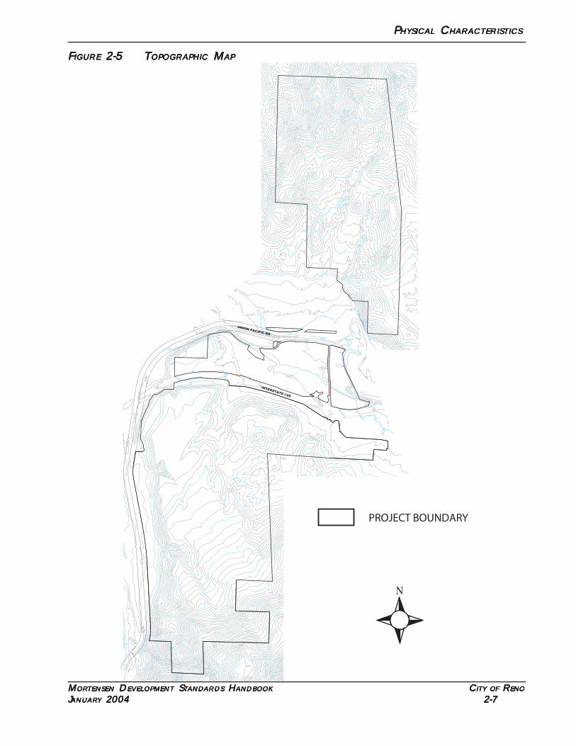
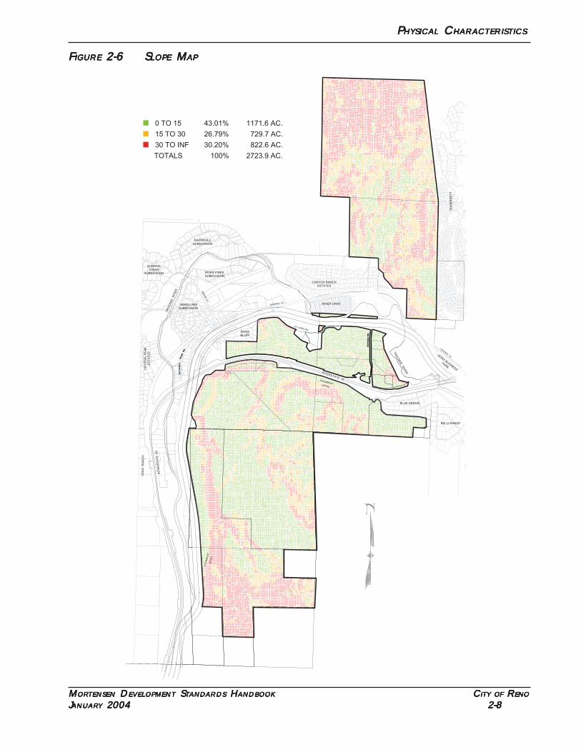
2.3 TOPOGRAPHY/SLOPES
The MDSH encompasses approximately ±2,723.9 acres. Figure 2-5 is a topographic map of theexisting, undisturbed project site with contours shown at 25 foot intervals. The terrain controls theextent and location of potential development in the project area.
Figure 2-6 is a slope map for the properties included in the MDSH. Slopes are defined in rangesof 0-15%, 15-30%, and 30% or greater. Washoe County Development Code (WCDC) Section110.424, Hillside Development, establishes that areas considered less suitable for development in-clude slopes greater than 30%. The majority of the areas within the MDSH that are 30% or greaterare at the extreme north and south edges of the project. These areas will be preserved as openspace. Additionally, the 30% slopes on the west edge of the project in the Quilici Ranch and adjacentto I-80 on the south portion of the Boomtown property will also be retained as open space.
Approximately ±1,908 acres of the property has slopes of 30% or less (70%). This compares toapproximately ±1,380 acres of the project area that is proposed for development.
Individual tentative maps and special use permits will be subject to a determination of compli-ance with the Hillside Development Standards section of this development standards handbook.
P P P P PHYSICALHYSICALHYSICALHYSICALHYSICAL C C C C CHARACTERISTICSHARACTERISTICSHARACTERISTICSHARACTERISTICSHARACTERISTICS
MMMMMORORORORORTENSENTENSENTENSENTENSENTENSEN D D D D DEVELEVELEVELEVELEVELOPMENTOPMENTOPMENTOPMENTOPMENT S S S S STTTTTANDANDANDANDANDARDSARDSARDSARDSARDS H H H H HANDBOOKANDBOOKANDBOOKANDBOOKANDBOOK C C C C CITYITYITYITYITY OFOFOFOFOF R R R R RENOENOENOENOENO
JJJJJANUARANUARANUARANUARANUARYYYYY 2004 2004 2004 2004 2004 2-7 2-7 2-7 2-7 2-7
FFFFFIGUREIGUREIGUREIGUREIGURE 2-5 T 2-5 T 2-5 T 2-5 T 2-5 TOPOGRAPHICOPOGRAPHICOPOGRAPHICOPOGRAPHICOPOGRAPHIC M M M M MAPAPAPAPAP
5300
5400
5500
5600
5700
5800
6100
6000
5900
4900
5100
5000
5100
5200
5200
5000
4900
5100
5100
4800
4900
5000
5400
53005300
5200
5000
5100
5300
5200
5100
5000
6000
6200
6100
6000
5900
5800
5700
5500
5400
5900
5800
5700
5600
5500
60005900
5100
5100
5000
INTERSTATE I-80
UNION PACIFIC RR
PROJECT BOUNDARY
P P P P PHYSICALHYSICALHYSICALHYSICALHYSICAL C C C C CHARACTERISTICSHARACTERISTICSHARACTERISTICSHARACTERISTICSHARACTERISTICS
MMMMMORORORORORTENSENTENSENTENSENTENSENTENSEN D D D D DEVELEVELEVELEVELEVELOPMENTOPMENTOPMENTOPMENTOPMENT S S S S STTTTTANDANDANDANDANDARDSARDSARDSARDSARDS H H H H HANDBOOKANDBOOKANDBOOKANDBOOKANDBOOK C C C C CITYITYITYITYITY OFOFOFOFOF R R R R RENOENOENOENOENO
JJJJJANUARANUARANUARANUARANUARYYYYY 2004 2004 2004 2004 2004 2-8 2-8 2-8 2-8 2-8
FFFFFIGUREIGUREIGUREIGUREIGURE 2-6 S 2-6 S 2-6 S 2-6 S 2-6 SLOPELOPELOPELOPELOPE M M M M MAPAPAPAPAP
CR
YS
TR
AL
PEA
K R
D.
GA
RS
ON
RD
.
36" PINE
STEAMBOAT
ST
EA
MB
OA
TD
ITC
H
DITCH
HIGHWAY 40
INTERSTATE 80
HIG
HW
AY 40
TR
UC
KE
E R
IVE
R
TR
UC
KE
E R
IVE
R
CANYON RANCH
ESTATES
SO. VERDI RD.
INT
ER
ST
AT
E 80
BLUE HERON
RIVER OAKS
VER
DI B
USIN
ESS
PAR
K
GO
LD
R
AN
CH
RIVERDALE
SUBDIVISION
SUNRISE
CREEK
SUBDIVISION RIVER PINES
SUBDIVISION
VERDI LAKE
SUBDIVISION
CR
YS
TA
L P
EA
K
ES
TA
TE
S
BR
IDG
E S
T.
822.6 AC.30.20%30 TO INF
729.7 AC.26.79%15 TO 30
1171.6 AC.43.01%0 TO 15
2723.9 AC.100%TOTALS
BELLI RANCH
SO
ME
RS
ET
T
VERDI
BLUFF
P P P P PHYSICALHYSICALHYSICALHYSICALHYSICAL C C C C CHARACTERISTICSHARACTERISTICSHARACTERISTICSHARACTERISTICSHARACTERISTICS
MMMMMORORORORORTENSENTENSENTENSENTENSENTENSEN D D D D DEVELEVELEVELEVELEVELOPMENTOPMENTOPMENTOPMENTOPMENT S S S S STTTTTANDANDANDANDANDARDSARDSARDSARDSARDS H H H H HANDBOOKANDBOOKANDBOOKANDBOOKANDBOOK C C C C CITYITYITYITYITY OFOFOFOFOF R R R R RENOENOENOENOENO
JJJJJANUARANUARANUARANUARANUARYYYYY 2004 2004 2004 2004 2004 2-9 2-9 2-9 2-9 2-9
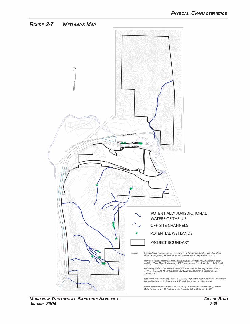
2.4 WETLANDS
Preliminary wetland delineations for the properties included in the MDSH have been preparedby JBR Environmental Consultants, Inc., and Huffman and Associates, Inc. These studies have beenincluded in Supporting Studies Book 2. Figure 2-7 depicts the general location and extent of wet-lands and Waters of the U.S. within the project boundaries.
Each tentative map, parcel map and special use permit must show the wetlands and waters ofthe U.S. Wetlands within the project will be protected and mitigated according to RMC, Wetlandsand Stream Environments. Wetlands will be avoided and retained as open space unless the locationof the wetland and or the physical characteristics of the site necessitate modification of a wetland. Inthis instance, the wetland must be be replaced at a minimum 2:1 ratio or as required by the US ArmyCorps of Engineers, whichever is more restrictive.
P P P P PHYSICALHYSICALHYSICALHYSICALHYSICAL C C C C CHARACTERISTICSHARACTERISTICSHARACTERISTICSHARACTERISTICSHARACTERISTICS
MMMMMORORORORORTENSENTENSENTENSENTENSENTENSEN D D D D DEVELEVELEVELEVELEVELOPMENTOPMENTOPMENTOPMENTOPMENT S S S S STTTTTANDANDANDANDANDARDSARDSARDSARDSARDS H H H H HANDBOOKANDBOOKANDBOOKANDBOOKANDBOOK C C C C CITYITYITYITYITY OFOFOFOFOF R R R R RENOENOENOENOENO
JJJJJANUARANUARANUARANUARANUARYYYYY 2004 2004 2004 2004 2004 2-10 2-10 2-10 2-10 2-10
FFFFFIGUREIGUREIGUREIGUREIGURE 2-7 W 2-7 W 2-7 W 2-7 W 2-7 WETLANDSETLANDSETLANDSETLANDSETLANDS M M M M MAPAPAPAPAP
36" PINE
N 01°00'18" W 1329.66
N 89°12'31" W 1333.55
N 89°12'45" W 1420.86
INTERSTATE I-80
UNION PACIFIC RR
U.S. HIGHWAY 40
POTENTIALLY JURISDICTIONALWATERS OF THE U.S.
PROJECT BOUNDARY
OFF-SITE CHANNELS
POTENTIAL WETLANDS
Sources: Promax Parcels Reconnaissance-Level Surveys For Jurisdictional Waters and City of Reno Major Drainageways, JBR Environmental Consultants, Inc., September 16, 2003.
Mortensen Parcels Reconnaissance-Level Surveys For Listed Species, Jurisdictional Waters and City of Reno Major Drainageways, JBR Environmental Consultants, Inc., July 28, 2003.
Preliminary Wetland Delineation for the Quilici Ranch Estates Property, Sections 20 & 29, T.19N, R.18E, M.D.B. & M., Verdi, Washoe County, Nevada, Huffman & Associates, Inc., June 13, 1997.
Location of Areas Potentially Subject to U.S. Army Corps of Engineers Jurisdiction - Preliminary Wetland Delineation For Boomtown, Huffman & Associates, Inc., March 1997.
Boomtown Parcels Reconnaissance-Level Surveys Jurisdictional Waters and City of Reno Major Drainageways, JBR Environmental Consultants, Inc., October 10, 2003.
D D D D DEVELOPMENTEVELOPMENTEVELOPMENTEVELOPMENTEVELOPMENT P P P P PLANLANLANLANLAN
MMMMMORORORORORTENSENTENSENTENSENTENSENTENSEN D D D D DEVELEVELEVELEVELEVELOPMENTOPMENTOPMENTOPMENTOPMENT S S S S STTTTTANDANDANDANDANDARDSARDSARDSARDSARDS H H H H HANDBOOKANDBOOKANDBOOKANDBOOKANDBOOK C C C C CITYITYITYITYITY OFOFOFOFOF R R R R RENOENOENOENOENO
JJJJJANUARANUARANUARANUARANUARYYYYY 2004 2004 2004 2004 2004 3-1 3-1 3-1 3-1 3-1
SSSSSECTIONECTIONECTIONECTIONECTION 3. D 3. D 3. D 3. D 3. DEVELOPMENTEVELOPMENTEVELOPMENTEVELOPMENTEVELOPMENT P P P P PLANLANLANLANLAN
3.1 LAND USE PLAN
Figure 3-1 represents the development plan for the properties included in the MDSH. This planwas prepared based on the studies included in the Supporting Studies Books 1 and 2 to address thecriteria included in the Settlement Agreement.
The development potential established in the MDSH is allocated to the four property ownersincluded in the MDSH. Table 3-1 defines the amount and type of development allocated to eachproperty owner. Adjustments to the total numbers and types of development allocated to eachowner may only be made as allowed in Section 6, Administration/Amendments of the MDSH. Ad-justments between property owners must be accompanied by a notarized authorization from thedonor property owner before they may be considered by the City of Reno.
TTTTTABLEABLEABLEABLEABLE 3-1 D 3-1 D 3-1 D 3-1 D 3-1 DEVELEVELEVELEVELEVELOPMENTOPMENTOPMENTOPMENTOPMENT P P P P POOOOOTENTIALTENTIALTENTIALTENTIALTENTIAL B B B B BYYYYY P P P P PRRRRROPEROPEROPEROPEROPERTYTYTYTYTY O O O O OWNERWNERWNERWNERWNER
Owner Acreage/Units
Mortensen
Boomtown
Santerra, LLC
Quilici
680 dwelling units
753 dwelling units
HC ±85 acres AC ±48 acres IC ±75 acres
1,180 dwelling units
NC ±15 acres IC ±12 acres
387 dwelling units
IC ±65 acres
Table 3-2 establishes the zoning districts for the property as identified on Figure 3-1. Exactlocations of zoning boundary lines will be defined with subsequent tentative maps, special use per-mits or parcel maps consistent with Figure 3-1, with the exception of the buffer areas adjacent to BelliRanch, Verdi Bluff and South Verdi Road. These areas shall be defined by legal descriptions andimplemented with the adoption of this handbook. Table 3-3 establishes the potential residentialdevelopment by Planning Area as identified on Figure 3-1.
D D D D DEVELOPMENTEVELOPMENTEVELOPMENTEVELOPMENTEVELOPMENT P P P P PLANLANLANLANLAN
MMMMMORORORORORTENSENTENSENTENSENTENSENTENSEN D D D D DEVELEVELEVELEVELEVELOPMENTOPMENTOPMENTOPMENTOPMENT S S S S STTTTTANDANDANDANDANDARDSARDSARDSARDSARDS H H H H HANDBOOKANDBOOKANDBOOKANDBOOKANDBOOK C C C C CITYITYITYITYITY OFOFOFOFOF R R R R RENOENOENOENOENO
JJJJJANUARANUARANUARANUARANUARYYYYY 2004 2004 2004 2004 2004 3-2 3-2 3-2 3-2 3-2
FFFFFIGUREIGUREIGUREIGUREIGURE 3-1 L 3-1 L 3-1 L 3-1 L 3-1 LANDANDANDANDAND U U U U USESESESESE P P P P PLANLANLANLANLAN
OPEN SPACE
OPEN SPACE
OPEN SPACE
OPEN SPACE
OPEN SPACE
OPEN SPACE
OPEN SPACE
OPEN SPACE
OPEN SPACE
12.8 AC
COMMERCIAL19.1 ACRES
BUSINESS PARK28.5 ACRES
BUSINESS
22.0 ACRES
3.3
PUBLIC FACILITYFIRE
TRUCK
13.0 AC SERVICESTATION
2.7 AC
CASINOPARKING
3.2 AC
BUSINESS PARK 15.9 ACRES
HOTEL CASINO19.3 ACRES
OPEN SPACE
OPEN SPACE
OPEN SPACE
EXISTING
15.9 ACRES
EXISTING
30.0 ACRES
SINGLE FAMILY RESIDENTIAL1 ACRE MINIMUM 16.1 ACRES
SINGLE FAMILY RESIDENTIAL26.2 ACRES
1 ACRE MINIMUM 10.8 AC
SINGLE FAMILY RESIDENTIAL67.7 ACRES
10 LOTS
14 LOTS
1 ACRE MIN. 3.6 AC
3 LOTS
OPEN SPACE
OPEN SPACE
WATER TANK0.9 ACRES
35.4 ACRES
ACRES
NC
237.3 ACRES
10.0 AC
BUSINESS PARK
4.8 AC
3.3 AC
CR
YS
TA
LPA
RK
R
D.
GA
RS
ON
RD
.
BUSINESS PARK
STEAMBOAT
ST
EA
MB
OA
TD
ITC
H
DITCH
HIGHWAY 40
INTERSTATE 80
HIG
HW
AY 40
TR
UC
KE
E R
IVE
R
TR
UC
KE
E R
IVE
R
CANYON RANCH
ESTATES
SO. VERDI RD.
INT
ER
ST
AT
E 80
BLUE HERON
BELLI RANCH
N.T.S.
RIVER OAKS
VER
DI B
USIN
ESS
PAR
K
GO
LD
R
AN
CH
SOMERSETT
LEGEND
PUBLIC FACILITY (PF)
HOTEL/CASINO (HC)
SINGLE FAMILY (SF 6)
SINGLE FAMILY (LLR 1)
ARTERIAL COMMERCIAL (AC)
RA
ILR
OA
D
SO
UTH
ER
N P
AC
IFIC
RAIL
RO
AD
SO
UTH
ER
N P
AC
IFIC
I-80
I-80
RAILROAD
SOUTHERN PACIFIC
SINGLE FAMILY (SF 9)
MUTLI-FAMILY (MF 14)
NEIGHBORHOOD COMMERCIAL (NC)
BUSINESS PARK (IC)
OPEN SPACE (OS)
SOMERSETT
RA
ILR
OA
D
SO
UT
HE
RN
PA
CIF
IC
RIVERDALE
SUBDIVISION
SUNRISE
CREEK
SUBDIVISION RIVER PINES
SUBDIVISION
VERDI LAKE
SUBDIVISION
CR
YS
TA
L P
EA
K
ES
TA
TE
S
BR
IDG
E S
T.
BR
IDG
E S
T.
463.8 ACRES
SCHOOL10.0 ACRES
ELEMENTARY
142.9 ACRES
OPEN SPACE
38.8 ACRES
19.8 ACRES
(242 DU)OR RV PARK10.4 ACRES
MULTI-FAMILY
PLANNING AREA 1
PLANNING AREA 2
PLANNING AREA 3
2.9 ACRES
COMMERCIAL2.5 ACRES
SINGLE FAMILY RESIDENTIAL
SINGLE FAMILY RESIDENTIAL
RV PARK
PARK
HOTEL CASINO
STOP
SINGLE FAMILY RESIDENTIAL
172 UNITS12.7 ACRES
CENTER5.0 AC
VILLAGE
65 AC
D D D D DEVELOPMENTEVELOPMENTEVELOPMENTEVELOPMENTEVELOPMENT P P P P PLANLANLANLANLAN
MMMMMORORORORORTENSENTENSENTENSENTENSENTENSEN D D D D DEVELEVELEVELEVELEVELOPMENTOPMENTOPMENTOPMENTOPMENT S S S S STTTTTANDANDANDANDANDARDSARDSARDSARDSARDS H H H H HANDBOOKANDBOOKANDBOOKANDBOOKANDBOOK C C C C CITYITYITYITYITY OFOFOFOFOF R R R R RENOENOENOENOENO
JJJJJANUARANUARANUARANUARANUARYYYYY 2004 2004 2004 2004 2004 3-3 3-3 3-3 3-3 3-3
TTTTTABLEABLEABLEABLEABLE 3-2 D 3-2 D 3-2 D 3-2 D 3-2 DEVELEVELEVELEVELEVELOPMENTOPMENTOPMENTOPMENTOPMENT P P P P POOOOOTENTIALTENTIALTENTIALTENTIALTENTIAL B B B B BYYYYY L L L L LANDANDANDANDAND U U U U USESESESESE D D D D DESIGNESIGNESIGNESIGNESIGNAAAAATIONTIONTIONTIONTION
Designation Abbreviation Acreage
Large Lot Residential
Single Family Residential (9,000 sq. ft.) Single Family Residential (6,000 sq. ft.)
Multi-Family (14 units per acre) Industrial Commercial
Public Facility Hotel Casino
Arterial Commercial Neighborhood Commercial
Open Space
LLR-1 SF9 SF6
MF14 IC PF HC AC NC OS
±31
±499 ±523 ±13
±152 ±14 ±85 ±48 ±15
±1,344
TTTTTABLEABLEABLEABLEABLE 3-3 R 3-3 R 3-3 R 3-3 R 3-3 RESIDENTIALESIDENTIALESIDENTIALESIDENTIALESIDENTIAL D D D D DEVELOPMENTEVELOPMENTEVELOPMENTEVELOPMENTEVELOPMENT P P P P POTENTIALOTENTIALOTENTIALOTENTIALOTENTIAL B B B B BYYYYY P P P P PLANNINGLANNINGLANNINGLANNINGLANNING A A A A AREAREAREAREAREA
Planning Area Residential Land Use Designation Dwelling Units
Planning Area 1
Planning Area 2
Planning Area 3
Single Family (SF6)
Single Family (LLR1) Single Family (SF6) Multi-Family (MF14)
Single Family (LLR1) Single Family (SF9) Single Family (SF6) Multi-Family (MF14)
676 units
13 units
270 units 242 units
14 units
1,019 units 594 units 172 units
3.2 TRAFFIC, CIRCULATION AND ACCESS
The land plan proposed with the MDSH was evaluated by Solaegui Engineers, Ltd. The trafficanalysis for this zoning map amendment is included in Supporting Studies Book 2, submitted withthis document.
Figure 3-2 depicts the proposed circulation plan for the MDSH.
D D D D DEVELOPMENTEVELOPMENTEVELOPMENTEVELOPMENTEVELOPMENT P P P P PLANLANLANLANLAN
MMMMMORORORORORTENSENTENSENTENSENTENSENTENSEN D D D D DEVELEVELEVELEVELEVELOPMENTOPMENTOPMENTOPMENTOPMENT S S S S STTTTTANDANDANDANDANDARDSARDSARDSARDSARDS H H H H HANDBOOKANDBOOKANDBOOKANDBOOKANDBOOK C C C C CITYITYITYITYITY OFOFOFOFOF R R R R RENOENOENOENOENO
JJJJJANUARANUARANUARANUARANUARYYYYY 2004 2004 2004 2004 2004 3-4 3-4 3-4 3-4 3-4
FFFFFIGUREIGUREIGUREIGUREIGURE 3-2 C 3-2 C 3-2 C 3-2 C 3-2 CIRIRIRIRIRCULACULACULACULACULATIONTIONTIONTIONTION P P P P PLANLANLANLANLAN
CR
YS
TR
AL
PEA
K R
D.
GA
RS
ON
RD
.
UNION PACIFIC RR
HIGHWAY 40
INTERSTATE 80
HIGHW
AY 40
TR
UC
KE
E R
IVE
R
TR
UC
KE
E R
IVE
R
CANYON RANCH
ESTATES
SO. VERDI RD.
INT
ER
ST
AT
E 80
BLUE HERON
BELLI RANCH
N.T.S.
RIVER OAKS
GO
LD
R
AN
CH
SOMERSETT
,
5220
131
5220
1002
0.00
8
RIVERDALE
SUBDIVISION
SUNRISE
CREEK
SUBDIVISION RIVER PINES
SUBDIVISION
VERDI LAKE
SUBDIVISION
CR
YS
TA
L P
EA
K
ES
TA
TE
S
BR
IDG
E S
T.
Project Boundary
Arterial
Collector
Local
P
P
Park and Ride Facility
D D D D DEVELOPMENTEVELOPMENTEVELOPMENTEVELOPMENTEVELOPMENT P P P P PLANLANLANLANLAN
MMMMMORORORORORTENSENTENSENTENSENTENSENTENSEN D D D D DEVELEVELEVELEVELEVELOPMENTOPMENTOPMENTOPMENTOPMENT S S S S STTTTTANDANDANDANDANDARDSARDSARDSARDSARDS H H H H HANDBOOKANDBOOKANDBOOKANDBOOKANDBOOK C C C C CITYITYITYITYITY OFOFOFOFOF R R R R RENOENOENOENOENO
JJJJJANUARANUARANUARANUARANUARYYYYY 2004 2004 2004 2004 2004 3-5 3-5 3-5 3-5 3-5
Two criteria for assessing the impacts of traffic were established by the Settlement Agreement.These include:
• Any impacts to traffic, level of service and level of congestion on the existing Verdi community;and,
• A traffic design, both interior and exterior to any development, minimizing traffic impacts onthe rest of the Verdi community.
The properties included in the MDSH are ideally located for the proposed development in-tended. They have access to two major roadways - Interstate 80 and US Highway 40. With theexception of the extension of roads through the Canyon Ranch Estates project and the extension ofa frontage road to connect to S. Verdi Road, the proposed roadway system does not create trafficthrough existing neighborhoods in Verdi. It should be noted that the Canyon Ranch Estates devel-opment, which is in the City of Reno, is planned for two collector streets which will accommodate thetraffic generated from this project. Additionally, the extension of a frontage road west to connect toS. Verdi Road will provide the opportunity to divert traffic from the narrow existing S. Verdi Roadimmediately north of Boomtown.
In order to assess the impacts of traffic from the project on existing Verdi residents, an objectivecalculation of level of service was prepared by Solaegui Engineers Ltd. The land use and transporta-tion element of the Washoe County Comprehensive Plan establishes a level of service C as the mini-mum acceptable level of service for roadways for which the County is responsible. Even though theroadways included in the MDSH will be the responsibility of the City of Reno, the traffic analysis andmitigations proposed have been designed to maintain a level of service C. Implementation of theproposed roadway system and mitigations will assure that traffic impacts from the project do notunduly burden roadways or create an unacceptable level of congestion.
A series of improvements will be provided with the development of the properties. These in-clude:
• Traffic signals will be constructed at the Garson Road intersections with the I-80 westboundramps, the Boomtown Access Road, the I-80 eastbound ramps and Warrior Lane when warrantedand that the signals will be interconnected to provide arterial progression on Garson Road.
• The Garson Road/I-80 Westbound Ramp intersection be constructed to include a minimumof one left turn lane and a shared through-right turn lane at the north and east approaches and oneleft turn lane, one through lane and a right turn lane at the west and south approaches. It is recom-mended that a minimum of 425 feet of left turn storage length be provided at the south approachand a minimum of 200 feet at the east, west and north approaches.
• The Garson Road/Boomtown Access Road intersection be improved to include a minimumof one left turn lane and a shared through-right turn lane at the north approach, one left turn lane,one through lane and an exclusive right turn lane at the south and east approaches and one left turn
D D D D DEVELOPMENTEVELOPMENTEVELOPMENTEVELOPMENTEVELOPMENT P P P P PLANLANLANLANLAN
MMMMMORORORORORTENSENTENSENTENSENTENSENTENSEN D D D D DEVELEVELEVELEVELEVELOPMENTOPMENTOPMENTOPMENTOPMENT S S S S STTTTTANDANDANDANDANDARDSARDSARDSARDSARDS H H H H HANDBOOKANDBOOKANDBOOKANDBOOKANDBOOK C C C C CITYITYITYITYITY OFOFOFOFOF R R R R RENOENOENOENOENO
JJJJJANUARANUARANUARANUARANUARYYYYY 2004 2004 2004 2004 2004 3-6 3-6 3-6 3-6 3-6
lane and a shared through-right turn lane at the north approach, one left turn lane, one through laneand a free right turn lane at the west approach. It is recommended that a minimum of 150 feet of leftturn storage length be provided at the north, south, east and west approaches.
• The Garson Road/I-80 Eastbound Ramp intersection will be improved to include dual left turnlanes and two through lanes at the north approach, a shared through-right turn lane and an exclu-sive right turn lane at the south approach and a shared left turn-through lane and an exclusive rightturn lane at the west approach. It is recommended that a minimum of 300 feet of storage length beprovided for each left turn lane at the north approach.
• The Garson Road/Warrior Lane/Project Access intersection will be constructed to include aminimum of one left turn lane, one through lane and an exclusive right turn lane at the north ap-proach, one left turn lane and a shared through-right turn lane at the south and east approachedand dual left turn lanes and a shared through-right turn lane at the west approach. It is recom-mended that a minimum of 175 feet of left turn storage length be provided for each left turn lane atthe west approach and a minimum of 150 feet at the north, south and east approaches.
• The Garson Road Extension/Garson Road North intersection will be improved to include aminimum of one left turn lane and a shared through-right turn lane at the north and south GarsonRoad Extension approaches and one left turn lane, one through lane and a right turn lane at the eastGarson Road North approach and the west convenience market approach. It is recommended thata minimum of 150 feet of left turn storage length be provided at the north, south, east and westapproaches.
• The U.S. 40/Summerset Drive/West Project Access intersection will be improved to includeone left turn lane, one through lane and a right turn lane at the east approach, one left turn lane anda shared through-right turn lane at the west approach and single lanes at the north and southapproaches. It is recommended that a minimum of 300 feet of left turn storage/deceleration lengthbe provided at the east and west approaches. It is recommended that the right turn lane at the eastapproach contain a minimum of 220 feet of deceleration length.
• The U.S. 40/East Project Access intersection will be improved to include one left turn lane andone through lane at the west approach, one through lane and a right turn lane at the east approachand a single lane at the north approach. It is recommended that a minimum of 300 feet of left turnstorage/deceleration length be provided at the west approach. It is recommended that the right turnlane at the east approach contain a minimum of 220 feet of deceleration length.
• The I-80 westbound off-ramp and eastbound on-ramp at the Garson interchange each willbe improved to include two lanes.
• The Garson Road overpass will be widened to contain two southbound through lanes andone northbound through lane between the Boomtown Access Road and I-80 eastbound rampswith a single northbound left turn lane at the Boomtown Access Road intersection and dual south-bound left turn lanes at the I-80 eastbound ramp intersection.
D D D D DEVELOPMENTEVELOPMENTEVELOPMENTEVELOPMENTEVELOPMENT P P P P PLANLANLANLANLAN
MMMMMORORORORORTENSENTENSENTENSENTENSENTENSEN D D D D DEVELEVELEVELEVELEVELOPMENTOPMENTOPMENTOPMENTOPMENT S S S S STTTTTANDANDANDANDANDARDSARDSARDSARDSARDS H H H H HANDBOOKANDBOOKANDBOOKANDBOOKANDBOOK C C C C CITYITYITYITYITY OFOFOFOFOF R R R R RENOENOENOENOENO
JJJJJANUARANUARANUARANUARANUARYYYYY 2004 2004 2004 2004 2004 3-7 3-7 3-7 3-7 3-7
• Garson Road will be constructed to contain two through lanes in each direction between theI-80 eastbound ramps and Warrior Lane with a single southbound left turn lane at the Warrior Laneintersection.
• Garson Road will be constructed to contain one lane in each direction between the BoomtownAccess Road and South Verdi Road with left turn pockets provided at the key intersections and projectdriveways.
• South Verdi Road between the I-80 westbound off-ramp and the project access road beimproved as a two-lane City of Reno residential collector street.
Each development application will include a traffic analysis identifying the roadway improve-ments necessitated by that particular development. This will assure that improvements are plannedto coincide with the need to maintain level of service C.
TRIP REDUCTION
In order to facilitate trip reduction, a park and ride Facility will be provided when determinedfeasible by the City of Reno and Regional Transportation Commission (RTC). Such a facility will beplaced at the southern end of the employment center located south of I-80. RTC has indicated fifty(50) parking spaces will be adequate for this facility. An area of approximately 6,000 square feetshould accomdate this facility. A temporary parking area will be provided prior to construction of thefire station at this location. With construction of the fire station, a permanent parking area will beprovided if warranted.
3.3 WATER
Capital Engineering has prepared a preliminary water plan for the MDSH (see Supporting Stud-ies Book 2). This water plan has been developed to outline a community water system that assuresthe availability of water resources and water delivery to the proposed MDSH development project.
The preliminary plan incorporates the existing Boomtown water system and couples it with theextension of Truckee Meadows Water Authority (TMWA) facilities to the MDSH properties from theMogul area. The preliminary planning includes the estimated water demands and supply, watertransmission and distribution, storage requirements and water rights discussion. General systemcomponents and a preliminary layout are provided in the plan.
Water rights are required for the development of the MDSH development project. The amountof water rights required are based on TMWA’s Rule 17. Rule 17 outlines a schedule of assumeddemands based on land usage including lot sizes. Most developments within the TMWA water
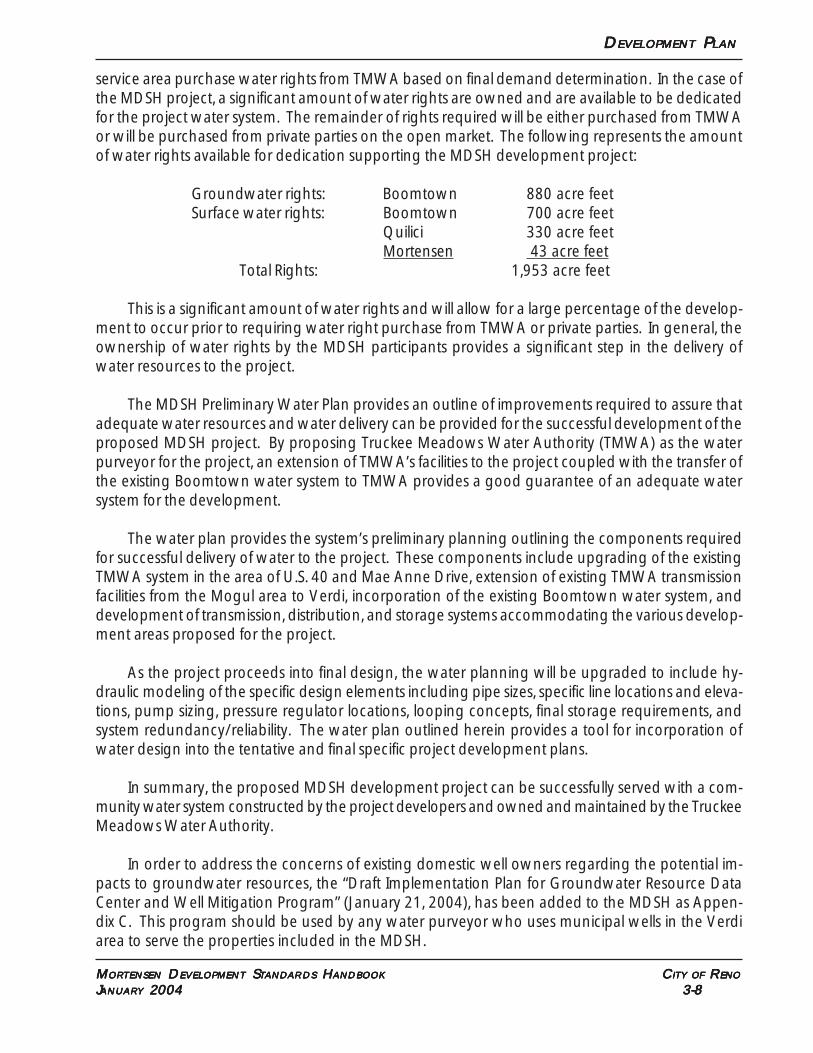
D D D D DEVELOPMENTEVELOPMENTEVELOPMENTEVELOPMENTEVELOPMENT P P P P PLANLANLANLANLAN
MMMMMORORORORORTENSENTENSENTENSENTENSENTENSEN D D D D DEVELEVELEVELEVELEVELOPMENTOPMENTOPMENTOPMENTOPMENT S S S S STTTTTANDANDANDANDANDARDSARDSARDSARDSARDS H H H H HANDBOOKANDBOOKANDBOOKANDBOOKANDBOOK C C C C CITYITYITYITYITY OFOFOFOFOF R R R R RENOENOENOENOENO
JJJJJANUARANUARANUARANUARANUARYYYYY 2004 2004 2004 2004 2004 3-8 3-8 3-8 3-8 3-8
service area purchase water rights from TMWA based on final demand determination. In the case ofthe MDSH project, a significant amount of water rights are owned and are available to be dedicatedfor the project water system. The remainder of rights required will be either purchased from TMWAor will be purchased from private parties on the open market. The following represents the amountof water rights available for dedication supporting the MDSH development project:
Groundwater rights: Boomtown 880 acre feetSurface water rights: Boomtown 700 acre feet
Quilici 330 acre feetMortensen 43 acre feet
Total Rights: 1,953 acre feet
This is a significant amount of water rights and will allow for a large percentage of the develop-ment to occur prior to requiring water right purchase from TMWA or private parties. In general, theownership of water rights by the MDSH participants provides a significant step in the delivery ofwater resources to the project.
The MDSH Preliminary Water Plan provides an outline of improvements required to assure thatadequate water resources and water delivery can be provided for the successful development of theproposed MDSH project. By proposing Truckee Meadows Water Authority (TMWA) as the waterpurveyor for the project, an extension of TMWA’s facilities to the project coupled with the transfer ofthe existing Boomtown water system to TMWA provides a good guarantee of an adequate watersystem for the development.
The water plan provides the system’s preliminary planning outlining the components requiredfor successful delivery of water to the project. These components include upgrading of the existingTMWA system in the area of U.S. 40 and Mae Anne Drive, extension of existing TMWA transmissionfacilities from the Mogul area to Verdi, incorporation of the existing Boomtown water system, anddevelopment of transmission, distribution, and storage systems accommodating the various develop-ment areas proposed for the project.
As the project proceeds into final design, the water planning will be upgraded to include hy-draulic modeling of the specific design elements including pipe sizes, specific line locations and eleva-tions, pump sizing, pressure regulator locations, looping concepts, final storage requirements, andsystem redundancy/reliability. The water plan outlined herein provides a tool for incorporation ofwater design into the tentative and final specific project development plans.
In summary, the proposed MDSH development project can be successfully served with a com-munity water system constructed by the project developers and owned and maintained by the TruckeeMeadows Water Authority.
In order to address the concerns of existing domestic well owners regarding the potential im-pacts to groundwater resources, the “Draft Implementation Plan for Groundwater Resource DataCenter and Well Mitigation Program” (January 21, 2004), has been added to the MDSH as Appen-dix C. This program should be used by any water purveyor who uses municipal wells in the Verdiarea to serve the properties included in the MDSH.
D D D D DEVELOPMENTEVELOPMENTEVELOPMENTEVELOPMENTEVELOPMENT P P P P PLANLANLANLANLAN
MMMMMORORORORORTENSENTENSENTENSENTENSENTENSEN D D D D DEVELEVELEVELEVELEVELOPMENTOPMENTOPMENTOPMENTOPMENT S S S S STTTTTANDANDANDANDANDARDSARDSARDSARDSARDS H H H H HANDBOOKANDBOOKANDBOOKANDBOOKANDBOOK C C C C CITYITYITYITYITY OFOFOFOFOF R R R R RENOENOENOENOENO
JJJJJANUARANUARANUARANUARANUARYYYYY 2004 2004 2004 2004 2004 3-9 3-9 3-9 3-9 3-9
3.4 SEWER
With the exception of the River Oaks Subdivision and Boomtown, all existing development inVerdi use septic systems for wastewater discharge. The Verdi Meadows Utility Company operates atreatment plant that serves the River Oaks Subdivision. Boomtown operates its own treatment plantto serve the hotel/casino, service station, truck stop and RV park.
Since the Verdi area eventually drains to the Truckee River, the regions major source of drinkingwater, it has long been recognized that community sewer service should be extended to the area. Infact, Washoe County’s Verdi Area Plan calls for the extension of the Lawton Verdi Interceptor toprevent unacceptable nitrate loadings into the Truckee River.
To address potential water quality concerns in the Verdi area, the City of Reno has authorizedthe extension of the Lawton Verdi Interceptor to Boomtown. The first phase of the interceptor exten-sion is currently under design and anticipated to be in place by late 2004. This phase will extend thesewer line to Boomtown.
All development proposed within the MDSH is intended to be served through the Lawton VerdiInterceptor to the Truckee Meadows Water Reclamation Facility (TMWRF).
To address the potential impacts of the project in terms of wastewater and to identify the avail-ability of wastewater service for the MDSH, a preliminary sanitary sewer report was prepared bySummit Engineering Corporation (see Supporting Studies Book 2). This report provides an estimateof the sewage to be generated onsite and identifies the basic back bone system to convey wastewa-ter flows. The study uses the City of Reno Public Works Design Manual and actual measured peakflows from Boomtown’s system to calculate estimated flows.
This sanitary sewer report concludes that the total development anticipated with the MDSH willgenerate a peak flow of 3.41 million gallons per day (MGD). The project will generate 2.90 MGD atthe Garson Road Interceptor. The design flow of the Garson Road Interceptor is 2.90 MGD. TheLawton Verdi Interceptor east of the Garson Road point of connection has a design flow of 5.10MGD. An estimated ultimate flow of 2.0 MGD is anticipated from points west of this connection, thusproviding more than adequate capacity for the Garson Road Interceptor flows.
TMWRF is currently operating at 31-32 MGD. It is scheduled to be expanded to 46.5 MGDstarting in spring of 2004.
It should also be noted that the project will be subject to sewer connection fees which will beused for plant capacity expansion as needed.
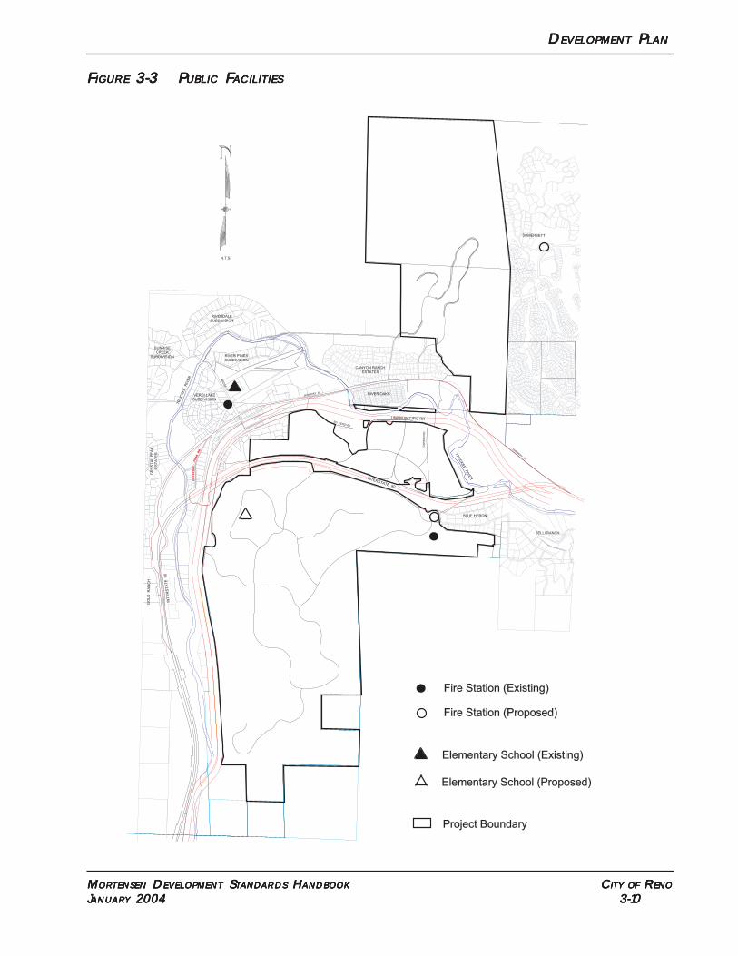
D D D D DEVELOPMENTEVELOPMENTEVELOPMENTEVELOPMENTEVELOPMENT P P P P PLANLANLANLANLAN
MMMMMORORORORORTENSENTENSENTENSENTENSENTENSEN D D D D DEVELEVELEVELEVELEVELOPMENTOPMENTOPMENTOPMENTOPMENT S S S S STTTTTANDANDANDANDANDARDSARDSARDSARDSARDS H H H H HANDBOOKANDBOOKANDBOOKANDBOOKANDBOOK C C C C CITYITYITYITYITY OFOFOFOFOF R R R R RENOENOENOENOENO
JJJJJANUARANUARANUARANUARANUARYYYYY 2004 2004 2004 2004 2004 3-10 3-10 3-10 3-10 3-10
FFFFFIGUREIGUREIGUREIGUREIGURE 3-3 P 3-3 P 3-3 P 3-3 P 3-3 PUBLICUBLICUBLICUBLICUBLIC F F F F FACILITIESACILITIESACILITIESACILITIESACILITIES
CR
YS
TR
AL
PEA
K R
D.
GA
RS
ON
RD
.
UNION PACIFIC RR
HIGHWAY 40
INTERSTATE 80
HIGHW
AY 40
TR
UC
KE
E R
IVE
R
TR
UC
KE
E R
IVE
R
CANYON RANCH
ESTATES
SO. VERDI RD.
INT
ER
ST
AT
E 80
BLUE HERON
BELLI RANCH
N.T.S.
RIVER OAKS
GO
LD
R
AN
CH
SOMERSETT
,
5220
131
5220
8
RIVERDALE
SUBDIVISION
SUNRISE
CREEK
SUBDIVISION RIVER PINES
SUBDIVISION
VERDI LAKE
SUBDIVISION
CR
YS
TA
L P
EA
K
ES
TA
TE
S
BR
IDG
E S
T.
Project Boundary
Elementary School (Existing)
Fire Station (Proposed)
Fire Station (Existing)
Elementary School (Proposed)
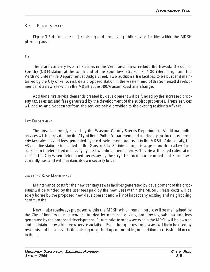
D D D D DEVELOPMENTEVELOPMENTEVELOPMENTEVELOPMENTEVELOPMENT P P P P PLANLANLANLANLAN
MMMMMORORORORORTENSENTENSENTENSENTENSENTENSEN D D D D DEVELEVELEVELEVELEVELOPMENTOPMENTOPMENTOPMENTOPMENT S S S S STTTTTANDANDANDANDANDARDSARDSARDSARDSARDS H H H H HANDBOOKANDBOOKANDBOOKANDBOOKANDBOOK C C C C CITYITYITYITYITY OFOFOFOFOF R R R R RENOENOENOENOENO
JJJJJANUARANUARANUARANUARANUARYYYYY 2004 2004 2004 2004 2004 3-11 3-11 3-11 3-11 3-11
3.5 PUBLIC SERVICES
Figure 3-3 defines the major existing and proposed public service facilities within the MDSHplanning area.
FIRE
There are currently two fire stations in the Verdi area, these include the Nevada Division ofForestry (NDF) station at the south end of the Boomtown/Garson Rd./I-80 interchange and theVerdi Volunteer Fire Department at Bridge Street. Two additional fire facilities, to be built and main-tained by the City of Reno, include a proposed station in the western end of the Somersett develop-ment and a new site within the MDSH at the I-80/Garson Road Interchange.
Additional fire service demands created by development will be funded by the increased prop-erty tax, sales tax and fees generated by the development of the subject properties. These serviceswill add to, and not detract from, the services being provided to the existing residents of Verdi.
LAW ENFORCEMENT
The area is currently served by the Washoe County Sheriffs Department. Additional policeservices will be provided by the City of Reno Police Department and funded by the increased prop-erty tax, sales tax and fees generated by the development proposed in the MDSH. Additionally, the±3 acre fire station site located at the Garson Rd./I-80 interchange is large enough to allow for asubstation if determined necessary by the law enforcement agency. This site will be dedicated, at nocost, to the City when determined necessary by the City. It should also be noted that Boomtowncurrently has, and will maintain, its own security force.
SEWER AND ROAD MAINTENANCE
Maintenance costs for the new sanitary sewer facilities generated by development of the prop-erties will be funded by the user fees paid by the new uses within the MDSH. These costs will besolely borne by the proposed new development and will not impact any existing and neighboringcommunities.
New major roadways proposed within the MDSH which remain public will be maintained bythe City of Reno with maintenance funded by increased gas tax, property tax, sales tax and feesgenerated by the proposed development. Future private roadways within the MDSH will be ownedand maintained by a homeowners association. Even though these roadways will likely be used byresidents and businesses in the existing neighboring communities, no additional costs should occurto them.
D D D D DEVELOPMENTEVELOPMENTEVELOPMENTEVELOPMENTEVELOPMENT P P P P PLANLANLANLANLAN
MMMMMORORORORORTENSENTENSENTENSENTENSENTENSEN D D D D DEVELEVELEVELEVELEVELOPMENTOPMENTOPMENTOPMENTOPMENT S S S S STTTTTANDANDANDANDANDARDSARDSARDSARDSARDS H H H H HANDBOOKANDBOOKANDBOOKANDBOOKANDBOOK C C C C CITYITYITYITYITY OFOFOFOFOF R R R R RENOENOENOENOENO
JJJJJANUARANUARANUARANUARANUARYYYYY 2004 2004 2004 2004 2004 3-12 3-12 3-12 3-12 3-12
FISCAL IMPACT
In 2000, the Truckee Meadows Regional Planning Agency hired Economic and Planning Sys-tems (EPS) to prepare a Truckee Meadows Fiscal Study. This study included all expenses incurred byReno, Sparks and Washoe County. This included fire, law enforcement and road maintenance.
Based on the technical memorandum by EPS dated July 18, 2000, the development anticipatedin the MDSH was estimated for its impact both on the City of Reno and Washoe County. This analysisshows that at year ten (10) with full buildout, the project is anticipated to create a surplus of $1.1million to the City of Reno. In terms of impacts to Washoe County and unincorporated residents, thisanalysis shows that the project is estimated to provide Washoe County with a surplus of $1.4 million(see Appendix B).
3.6 STORM WATER
To address storm water impacts of the development proposed in the MDSH, a master hydrol-ogy study was prepared by Nimbus Engineers (see Supporting Studies Book 3). Nimbus preparedhydrologic models for existing and proposed conditions for the 5-year and 100-year storm events.Nimbus used the U.S. Army Corps of Engineers Flood Hydrographs HEC - HMS 2.1.2 (2002) pro-gram and the procedures in the Washoe County Hydrologic Criteria and Drainage Design Manual(1996) to develop watershed parameters.
Nimbus found that outside the vicinity of the Truckee River, the project is not within the 100-yearregulatory flood plain. The study concluded that the increase in peak flow from the majority of thewatersheds is minimal.
The stormwater plan for the properties will consist of the following:
1. The master hydrology study will be used in specific project designs through the tentative mapand special use permit process to define exact location and sizes of detention basins in accor-dance with Reno Municipal Code.
2. Major drainage courses will be maintained and used to perpetrate stormwater flows.
3. Roadway crossings of major drainage courses will be used to provide detention to maintainpredevelopment stormwater flows.
4. Best management practices (BMP’s) will be used during development to assure water qualityis maintained. This will be administered throught the NDEP Storm Water Pollution PreventionPlan (SWPPP).
D D D D DEVELEVELEVELEVELEVELOPMENTOPMENTOPMENTOPMENTOPMENT S S S S STTTTTANDANDANDANDANDARDSARDSARDSARDSARDS
MMMMMORORORORORTENSENTENSENTENSENTENSENTENSEN D D D D DEVELEVELEVELEVELEVELOPMENTOPMENTOPMENTOPMENTOPMENT S S S S STTTTTANDANDANDANDANDARDSARDSARDSARDSARDS H H H H HANDBOOKANDBOOKANDBOOKANDBOOKANDBOOK C C C C CITYITYITYITYITY OFOFOFOFOF R R R R RENOENOENOENOENO
JJJJJANUARANUARANUARANUARANUARYYYYY 2004 2004 2004 2004 2004 4-1 4-1 4-1 4-1 4-1
SSSSSECTIONECTIONECTIONECTIONECTION 4. D 4. D 4. D 4. D 4. DEVELEVELEVELEVELEVELOPMENTOPMENTOPMENTOPMENTOPMENT S S S S STTTTTANDANDANDANDANDARDSARDSARDSARDSARDS
All development withtin the MDSH shall comply with the standards for each correspondingzoning district as set forth in the Reno Municipal Code Title 18, as shown on Figure 3-1, unlessotherwise stated in this handbook. Any matters not specifically addressed in the handbook shallcomply with applicable City of Reno Code requirements. Where there is a conflict between CityCode and the MDSH, the handbook shall prevail.
4.1 USES
Uses permitted within each zoning district shall be those identified in Reno Municipal Code withthe exception of the following uses which shall be prohibited:
• Auto repair garage, paint and body shop (does not include quick lube or vehicle maintainceassociated with service station);
• Single room occupancy;• Adult business;• Towing and impound yard;• Blood plasma donor center• Outdoor manufacturing, processing, assembly or fabrication;• Outdoor storage;• Salvage or reclamation products (indoors);• Tattoo parlor, body painting and similar uses;• Laundry, self service; or• Theaters (in AC and IC only - allowed in HC).
4.2 HILLSIDE DEVELOPMENT
PURPOSE
The purpose of this article, Hillside Development, is to regulate hillsides in a manner differentfrom regulation of flat terrain. This article established provisions for developing, preserving and pro-tecting hillsides and ridgelines. The intent of these regulations is to protect the public health , safetyand welfare by:
(a) Minimizing use of slopes subject to instability, erosion, landslide, flood hazards or drain-age problems;
D D D D DEVELEVELEVELEVELEVELOPMENTOPMENTOPMENTOPMENTOPMENT S S S S STTTTTANDANDANDANDANDARDSARDSARDSARDSARDS
MMMMMORORORORORTENSENTENSENTENSENTENSENTENSEN D D D D DEVELEVELEVELEVELEVELOPMENTOPMENTOPMENTOPMENTOPMENT S S S S STTTTTANDANDANDANDANDARDSARDSARDSARDSARDS H H H H HANDBOOKANDBOOKANDBOOKANDBOOKANDBOOK C C C C CITYITYITYITYITY OFOFOFOFOF R R R R RENOENOENOENOENO
JJJJJANUARANUARANUARANUARANUARYYYYY 2004 2004 2004 2004 2004 4-2 4-2 4-2 4-2 4-2
(b) Minimizing the careless alteration of and disruption to the natural topography andlandscape;
(c) Providing safe and adequate vehicular and pedestrian access to and within hillsideareas, including emergency access;
(d) Establishing stormwater runoff and erosion control techniques to minimize adversewater quality impacts resulting from non-point runoff;
(e) Encouraging innovative grading techniques and building design which respond tothe hillside terrain and natural contours of the land;
(f) Minimizing impacts on existing trees and vegetation which reduce erosion, stabilizesteep hillsides, enhance visual quality, protect water quality and preserve critical water-shed recharge areas;
(g) Encouraging the transfer of density to avoid hazardous areas and to protect environ-mentally sensitive and open space areas; and
(h) Minimizing impacts on prominent ridgelines, significant viewsheds, canyons and visu-ally prominent rock outcroppings which reflect the visual value and scenic characterof hillside areas.
APPLICABILITY
The provisions set forth in this article shall apply as follows:
(a) Hillside and Ridgeline Development. This article applies to all new development thatrequires tentative maps or special use permits by the City of Reno and meets the fol-lowing criteria:
(1) Properties containing slopes in excess of fifteen (15) percent or greater on 20percent or more of the site.
APPLICATION REQUIREMENTS AND PROCEDURES
In place of the application requirements found in the Hillside Development section of RenoDevelopment Code, the following submittals shall be required for all hillside development:
(a) Site Analysis. A site analysis, prepared by a qualified engineer, planner, landscapearchitect or architect shall be submitted. This analysis shall provide the basis for assess-ing the opportunities and constraints of the site for development and shall be in theform of a design standards handbook incorporating both textual and graphical repre-sentations of the requested action. At a minimum, a site analysis shall indicate:
D D D D DEVELEVELEVELEVELEVELOPMENTOPMENTOPMENTOPMENTOPMENT S S S S STTTTTANDANDANDANDANDARDSARDSARDSARDSARDS
MMMMMORORORORORTENSENTENSENTENSENTENSENTENSEN D D D D DEVELEVELEVELEVELEVELOPMENTOPMENTOPMENTOPMENTOPMENT S S S S STTTTTANDANDANDANDANDARDSARDSARDSARDSARDS H H H H HANDBOOKANDBOOKANDBOOKANDBOOKANDBOOK C C C C CITYITYITYITYITY OFOFOFOFOF R R R R RENOENOENOENOENO
JJJJJANUARANUARANUARANUARANUARYYYYY 2004 2004 2004 2004 2004 4-3 4-3 4-3 4-3 4-3
(1) Major topographic conditions including ridgelines, ravines canyons and knolls;
(2) Preliminary geological conditions including major rock outcroppings, slide ar-eas and areas underlain with faults that have been active during the Holoceneepoch of geological time;
(3) Preliminary soil conditions including soil type, expansiveness, slumping, erod-ibility and permeability;
(4) Significant surface hydrological conditions including natural drainage courses,perennial streams, floodplains, wetlands and ponding areas;
(5) The location and types of significant vegetation including known rare andendangered plant species and general plant communities;
(6) Habitat areas for rare or endangered animal species;
(7) Preliminary viewshed analysis including cross sections of views to and fromthe development site from all major roadways within one (1) mile of the projectsite, and from major focal points on the project site;
(8) How the development responds to the unique conditions of the hillside and;
(9) A slope analysis, submitted on a topographic map with contour intervals of atleast five (5) feet for planning purposes. This analysis shall indicate the locationand amount of land included within the following slope categories, tabulatedin acres:
(i) 0-15 percent;
(ii) 15-20 percent;
(iii) 20-25 percent;
(iv) 25-30 percent; and
(v) Greater than 30 percent.
(b) Developable Area Map. A developable area map, prepare pursuant to the followingSection on Determination of Developable Area.
(c) Constraint and Mitigation Analysis. A detailed analysis of how the identified con-straints will be mitigated and incorporated into the project’s design.
(d) Detailed Contour Analysis. A topographic map with more or less detailed contourintervals may be required by the Zoning Administrator for design purposes.
D D D D DEVELEVELEVELEVELEVELOPMENTOPMENTOPMENTOPMENTOPMENT S S S S STTTTTANDANDANDANDANDARDSARDSARDSARDSARDS
MMMMMORORORORORTENSENTENSENTENSENTENSENTENSEN D D D D DEVELEVELEVELEVELEVELOPMENTOPMENTOPMENTOPMENTOPMENT S S S S STTTTTANDANDANDANDANDARDSARDSARDSARDSARDS H H H H HANDBOOKANDBOOKANDBOOKANDBOOKANDBOOK C C C C CITYITYITYITYITY OFOFOFOFOF R R R R RENOENOENOENOENO
JJJJJANUARANUARANUARANUARANUARYYYYY 2004 2004 2004 2004 2004 4-4 4-4 4-4 4-4 4-4
DETERMINATION OF DEVELOPABLE AREA
To determine the location and amount of land suitable to support development, a developablearea analysis is required on a hillside property.
(a) Purpose. The purpose of identifying the developable area of a hillside is to designatethose areas suited for development and construction as evidenced by soils, geotechnical,biological and hydrological investigations and studies. A developable area analysis isrequired to ensure that the proposed project complies with the intent, standards andrequirements of this article.
(b) Developable Area Map. The developable area analysis shall be in the form of adevelopable area map; shall be drawn at a scale appropriate to the project; shallidentify the location and amount of total land area suitable for development pursuantto Section (c) below; and shall be prepared by a qualified engineer, planner, landscape architect or architect.
(c) Determination of Developable Area. Areas considered less suitable for developmentinclude:
(1) Slopes greater than thirty (30) percent, based on a slope analysis;
(2) Areas of landslides or landslide potential;
(3) Areas underlain with faults that have been active during the Holocene epochof geological time;
(4) Habitat areas of known rare or endangered plant or animal species; and
(5) Significant streams, ravines and drainageways.
(d) Exceptions. Development shall be permitted within areas of a hillside property con-sidered less suitable for development by the Zoning Administrator due to extenuatingcircumstances, provided the applicant can demonstrate that:
(1) The purposes of this article will not be compromised;
(2) Unstable slopes proposed for development will be sufficiently stabilized;
(3) Areas of landslide or landslide potential proposed for development will bestabilized;
(4) Earthquake resistant structures will be constructed on development sites pro-posed on potential earthquake areas;
D D D D DEVELEVELEVELEVELEVELOPMENTOPMENTOPMENTOPMENTOPMENT S S S S STTTTTANDANDANDANDANDARDSARDSARDSARDSARDS
MMMMMORORORORORTENSENTENSENTENSENTENSENTENSEN D D D D DEVELEVELEVELEVELEVELOPMENTOPMENTOPMENTOPMENTOPMENT S S S S STTTTTANDANDANDANDANDARDSARDSARDSARDSARDS H H H H HANDBOOKANDBOOKANDBOOKANDBOOKANDBOOK C C C C CITYITYITYITYITY OFOFOFOFOF R R R R RENOENOENOENOENO
JJJJJANUARANUARANUARANUARANUARYYYYY 2004 2004 2004 2004 2004 4-5 4-5 4-5 4-5 4-5
(5) Areas of rare and endangered animal or plant habitat proposed for develop-ment will be relocated and mitigation measures adhered to; and
(6) Significant ridgelines, rock outcroppings, canyons and landforms will be pro-tected to the greatest extent possible.
PROTECTED OPEN SPACE AREAS
Any portion of a hillside development which has been deemed unsuitable for developmentpursuant to this section shall be designated as permanent open space and shall be subject to thefollowing provisions:
(a) Permitted Uses. Uses permitted within the permanent open space areas shall bethose that are directly related to the open space function of the land, are necessary toprovide community services, or are necessary for the health, safety or welfare of thepublic. The following uses and facilities shall be permitted in the permanent openspace areas:
(1) Paved and unpaved pedestrian, equestrian and bicycle paths and trails;
(2) Outdoor recreational uses and facilities such as skiing, fishing, boating, swim-ming, horseback riding, nature observation, community parks and picnicareas;
(3) Roads, bridges and culverts for vehicles, pedestrians, bicyclists or equestriansused to provide access to permitted open space uses or to developable areas;
(4) Installations, maintenance and operation of typical utilities; and
(5) Dams, swales, detention ponds and impoundment areas, wetlands and wet-lands mitigation sites, and other structures necessary to prevent flooding anderosion, and to protect water quality.
(b) Land Restriction. A deed restriction, easement, offer of dedication, or other convey-ance describing limitations placed on the permanent open space areas of the prop-erty shall be recorded concurrent with the issuance of a development permit. Therestriction shall include provisions for the management and maintenance of the prop-erty. Where appropriate, open space shall be dedicated to a public agency.