Embed Size (px)
Citation preview
MOTEL DRIVE (AKA RAILROAD AVENUE)
REVITALIZATION PLAN
PREPARED FOR: CITY OF LORDSBURG
LORDSBURG, NM
TECHNICAL ASSISTANCE BY: COMMUNITYBYDESIGN
MILAGRO DESIGN JOHN W. MURPHEY, FtRSTLiGHT CONSULTING
HARWICK TRANSPORTATION GROUP
A NEW MEXICO FRONTIER COMMUNITY
OCTOBER 6 , 20 1 4
MOTEL DRIVE REVITALIZAT ION PLAN
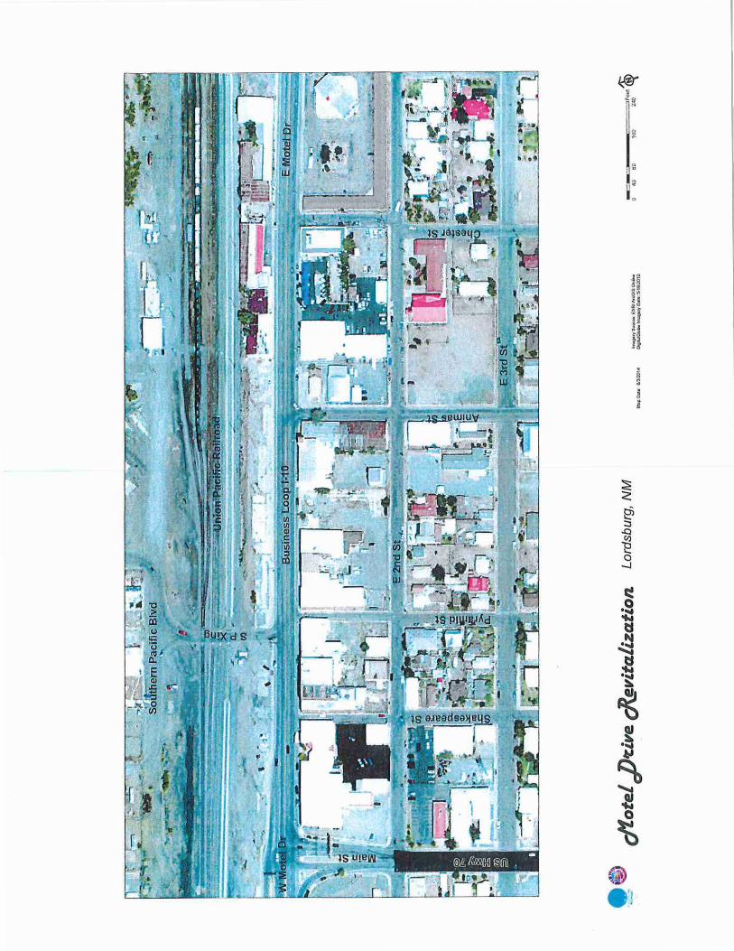
Introduction The revitalization plan for historic Motel Drive provides the framework and process for achieving the renewal of several blocks within the historic core of Lordsburg. The area includes the four blocks of Motel Drive/Business Loop 1-10 located between Main Street and Chester Street.
In 2014, the City of Lordsburg was selected as a recipient of technical assistance under New Mexico's Frontier Communities Initiative. The initiative is a community development partnership being implemented under the NM Economic Development Department's MainStreet Program.
Lordsburg identified street improvements and revitalization as its catalytic economic development project to enhance its historic commercial district. The Motel Drive design concept report and process is prepared through technical assistance from the program's associates and is funded through the NM MainStreet/Economic Development Department's legislative appropriation.
Purpose At the outset of the project a stakeholders group was formed consisting of public officials, business owners and local citizens.
Based on meetings with this group the following needs and issues were identified:
• Economic instability and lack of businesses
• Lack of safety and security • High traffic speeds on Motel Drive
• Street not amenable to pedestrian and bicycle users • Deteriorating buildings and vacant parcels
• Low walkability and visitor wayfinding
Project Goals Motel Drive Revitalization Goals:
• Enhance the image and character of the district through street and pedestrian improvements. • Create a thriving locally-owned business environment.
• Support a walkable and livable community.
• Enhance tourism and the economic vitality of downtown Lordsburg.
• Reinforce the identity as a railroad community. • Create a sense of security, identity, and economic stability.
• Create event opportunities for community and tourists
LORDSBURG FRONTIER COMMUNITY P AGE 1
MOT EL DRIVE REVITAUZATION PLAN
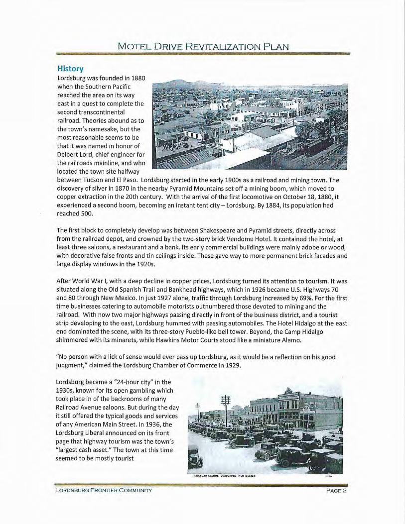
History lordsburg was founded in 1880 when the Southern Pacific reached the area on its way east in a quest to complete the second transcontinental railroad. Theories abound as to the town's namesake, but the most reasonable seems to be that it was named in honor of Delbert lord, chief engineer for the railroads mainline, and who located the town site halfway between Tucson and El Paso. lordsburg started in the early 1900s as a railroad and mining town. The discovery of silver in 1870 in the nearby Pyramid Mountains set off a mining boom, which moved to copper extraction in the 20th century. With the arrival of the first locomotive on October 18, 1880, it experienced a second boom, becoming an instant tent city -lordsburg. By 1884, its population had reached 500.
The first block to completely develop was between Shakespeare and Pyramid streets, directly across from the railroad depot, and crowned by the two-story brick Vendome Hotel. It contained the hotel, at least three saloons, a restaurant and a bank. Its early commercial buildings were mainly adobe or wood, with decorative false fronts and tin ceilings inside. These gave way to more permanent brick facades and large display windows in the 1920s.
After World War I, with a deep decline in copper prices, lordsburg turned its attention to tourism. It was situated along the Old Spanish Trail and Bankhead highways, which in 1926 became U.S. Highways 70 and 80 through New Mexico. In just 1927 alone, traffic through lordsburg increased by 69%. For the first time businesses catering to automobile motorists outnumbered those devoted to mining and the railroad. With now two major highways passing directly in front of the business district, and a tourist strip developing to the east, lordsburg hummed with passing automobiles. The Hotel Hidalgo at the east end dominated the scene, with its three-story Pueblo-like bell tower. Beyond, the Camp Hidalgo shimmered with its minarets, while Hawkins Motor Courts stood like a miniature Alamo.
"No person with a lick of sense would ever pass up lordsburg, as it would be a reflection on his good judgment," claimed the lordsburg Chamber of Commerce in 1929.
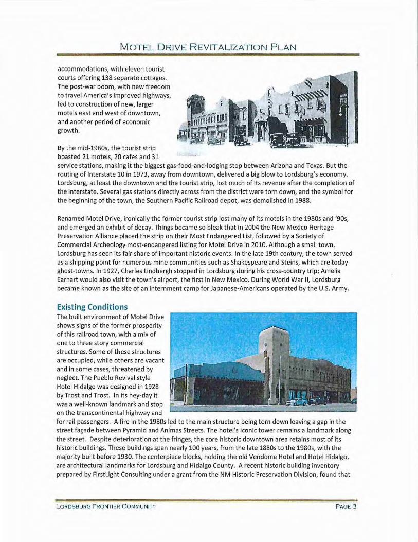
lordsburg became a "24-hour city" in the 1930s, known for its open gambling which took place in of the back rooms of many Railroad Avenue saloons. But during the day it still offered the typical goods and services of any American Main Street. In 1936, the lordsburg liberal announced on its front page that highway tourism was the town's "largest cash asset." The town at this time seemed to be mostly tourist
LORDS BURG FRO NTIER COMMUNITY
I L- - ~~ "'"--' -
RAILII;OAD I.YENUC, I.OI OS.U~G. " I:W IUl iCO,
PAGE 2
MOTEL D RIVE R EVITALIZATION PLAN
accommodations, with eleven tourist courts offering 138 separate cottages. The post-war boom, with new freedom to travel America's improved highways, led to construction of new, larger motels east and west of downtown, and another period of economic growth.
By the mid-1960s, the tourist strip boasted 21 motels, 20 cafes and 31 service stations, making it the biggest gas-food-and-lodging stop between Arizona and Texas. But the routing of Interstate 10 in 1973, away from downtown, delivered a big blow to Lordsburg's economy. Lordsburg, at least the downtown and the tourist strip, lost much of its revenue after the completion of the interstate. Several gas stations directly across from the district were torn down, and the symbol for the beginning of the town, the Southern Pacific Railroad depot, was demolished in 1988.
Renamed Motel Drive, ironically the former tourist strip lost many of its motels in the 1980s and '90s, and emerged an exhibit of decay. Things became so bleak that in 2004 the New Mexico Heritage Preservation Alliance placed the strip on their Most Endangered List, followed by a Society of Commercial Archeology most-endangered listing for Motel Drive in 2010. Although a small town, Lordsburg has seen its fair share of important historic events. In the late 19th century, the town served as a shipping point for numerous mine communities such as Shakespeare and Steins, which are today ghost-towns. In 1927, Charles Lindbergh stopped in Lordsburg during his cross-country trip; Amelia Earhart would also visit the town's airport, the first in New Mexico. During World War II, Lordsburg became known as the site of an internment camp for Japanese-Americans operated by the U.S. Army.
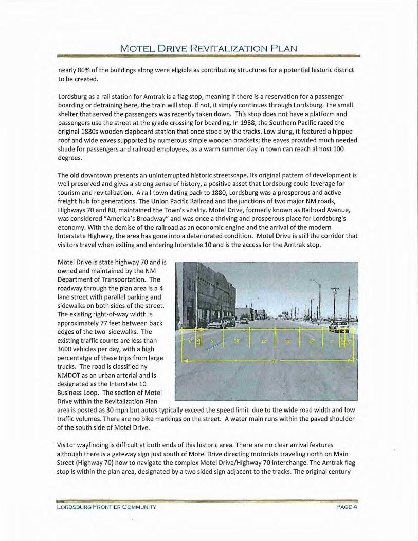
Existing Conditions The built environm ent of Motel Drive shows signs of the former prosperity of this railroad town, with a mix of one to three story commercial structures. Some of these structures are occupied, while others are vacant and in some cases, threatened by neglect. The Pueblo Revival style Hotel Hidalgo was designed in 1928 by Trost and Trost. In its hey-day it was a well-known landmark and stop on the transcontinental highway and for rail passengers. A fire in the 1980s led to the main structure being torn down leaving a gap in the street fac;ade between Pyramid and Animas Streets. The hotel's iconic tower remains a landmark along the street. Despite deterioration at the fringes, the core historic downtown area retains most of its historic buildings. These buildings span nearly 100 years, from the late 1880s to the 1980s, with the majority built before 1930. The centerpiece blocks, holding the old Vendome Hotel and Hotel Hidalgo, are architectural landmarks for Lordsburg and Hidalgo County. A recent historic building inventory prepared by Firstlight Consulting under a grant from the NM Historic Preservation Division, found that
LORDSBURG F RO NTIER COMMUNITY P AGE3
MOTEL DRIVE REVITALIZATION PLAN
nearly 80% of the buildings along were eligible as contributing structures for a potential historic district to be created.
Lordsburg as a rail station for Amtrak is a flag stop, meaning if there is a reservation for a passenger boarding or detraining here, the train wi ll stop. If not, it simply continues through Lordsburg. The small shelter that served the passengers was recently taken down. This stop does not have a platform and passengers use the street at the grade crossing for boarding. In 1988, the Southern Pacific razed the original 1880s wooden clapboard station that once stood by the tracks. Low slung, it featured a hipped roof and wide eaves supported by numerous simple wooden brackets; the eaves provided much needed shade for passengers and railroad employees, as a warm summer day in town can reach almost 100 degrees.
The old downtown presents an uninterrupted historic streetscape. Its original pattern of development is well preserved and gives a strong sense of history, a positive asset that Lordsburg could leverage for tourism and revitalization . A rail town dating back to 1880, Lordsburg was a prosperous and active freight hub for generations. The Union Pacific Railroad and the junctions of two major NM roads, Highways 70 and 80, maintained the Town's vitality. Motel Drive, formerly known as Railroad Avenue, was considered "America's Broadway" and was once a thriving and prosperous place for Lordsburg's economy. With the demise of the railroad as an economic engine and the arrival of the modern Interstate Highway, the area has gone into a deteriorated condition. Motel Drive is still the corridor that visitors travel when exiting and entering Interstate 10 and is the access for the Amtrak stop.
Motel Drive is state highway 70 and is owned and maintained by the NM Department of Transportation. The roadway through the plan area is a 4 lane street with parallel parking and sidewalks on both sides of the street. The existing right-of-way width is approximately 77 feet between back edges of the two sidewalks. The existing traffic counts are less than 3600 vehicles per day, with a high percentatge of these trips from large trucks. The road is classified ny NMDOT as an urban arterial and is designated as the Interstate 10 Business Loop. The section of Motel Drive within the Revitalization Plan
'1'' ··~
area is posted as 30 mph but autos typically exceed the speed limit due to the wide road w idth and low traffic volumes. There are no bike markings on the street. A water main runs within the paved shoulder of the south side of Motel Drive.
Visitor wayfinding is difficult at both ends of this historic area. There are no clear arrival features although there is a gateway sign just south of Motel Drive directing motorists traveling north on Main Street (Highway 70} how to navigate the complex Motel Drive/Highway 70 interchange. The Amtrak flag stop is within the plan area, designated by a two sided sign adjacent to the tracks. The original century
LORDSBURG FRONTIER COMMUNITY PAGE 4
MOTEL DRIVE REVITALIZATION PLAN
old wooden station was razed by Southern Pacific in 1988. The Union Pacific at grade crossing is used by oversize loads to avoid the undersized underpasses of the Highway 70 interchange heading north.
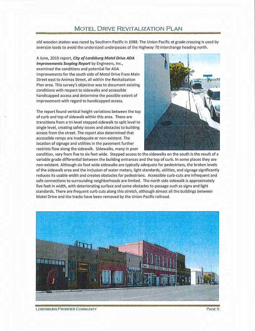
A June, 2010 report, City of Lordsburg Motel Drive ADA Improvements Scoping Report by Engineers, Inc., examined the conditions and potential for ADA improvements for the south side of Motel Drive from Main Street east to Animas Street, all within the Revitalization Plan area. This survey's objective was to document existing conditions w ith respect to sidewalks and accessible handicapped access and determine the possible extent of improvement with regard to handicapped access.
The report found vertical height variations between the top of curb and top of sidewalk within this area. There are transitions from a tri-level stepped sidewalk to split level to single level, creating safety issues and obstacles to building access from the street. The report also determined that accessible ramps are inadequate or non-existent. The location of signage and utilities in the pavement further restricts flow along the sidewalk. Sidewalks, many in poor condition, vary from five to six feet wide. Stepped access to the sidewalks on the south is the result of a variable grade differential between the building entrances and the top of curb. In some places they are non-existent. Although six foot wide sidewalks are typically adequate for pedestrians, the broken levels of the sidewa lk area and the inclusion of water meters, light standards, utilities, and sign age significantly reduces its usable width and creates obstacles for pedestrians. Accessible curb-cuts are infrequent and safe connections to surrounding neighborhoods are limited. The north side si dewalk is approximately five feet in width, with deteriorating surface and some obstacles to passage such as signs and light standards. There are frequent curb cuts along this stretch, although almost all the buildings between Motel Drive and the tracks have been removed by the Union Pacific railroad.
L ORDSBURG F RONTIER COMMUNilY PAGE5
MOTEL DRIVE REVITALIZATION PLAN
Stakeholder and Community Participation A community involvement process was used in developing the Motel Drive Revitalization Plan. The City of Lordsburg and Southwest NM Council of Government staff organized a 15-member stakeholder group to work with the NM MainStreet consu ltant team in developing the Revitalization Plan. The stakeholder group included members ofthe business community, elected city and county officials, and interested community members. Three meetings were held with the stakeholder group during the plan development.
At the first meeting, held May 13, 2014, the stakeholder group identified issues and opportunities along historic Motel Drive and the surrounding neighborhood. Many of the issues from the group dealt with the existing design of Motel Drive, so it was determined that NM DOT staff should be involved in future meetings.
A second meeting on July 14, 2014 presented a Revitalization concept that included pedestrian, bike and street improvements, public placemaking, and entries and gateways, and several revitalization strategies. The stakeholders responded to the specific concepts and ideas. Representatives of NM DOT and Engineers Inc expanded on the current status of the roadway and on planning of ADA improvements along the south side of the street. Representatives from NMDOT explained the limited funding opportunities and provided comments on the draft conceptual plan. The consultant team worked with the NMDOT staff in determining an acceptable street cross section and design features. The consu ltant team took that feedback and generated a preferred draft for the Motel Drive Revitalization Plan.
A third meeting, held on September 30, 2014, presented this preferred Revitalization Plan concept and strategies. The stakeholder members and NMDOT staff were supportive of the preferred concept plan and recommendations.
Design Concept and Recommendations Historic Lordsburg would benefit from enhancements to the visual quality of the streetscape and enhancements to the appearance and usability of the street for all users while continuing to celebrate the cultural roots of the Town and its history, including its mining, rail, and auto heritage. The community would profit from highlighting Motel Drive entries and improvements which slow traffic, make it easy to cross the street and walk to shops and encourage more people to gather and socialize on the street.
Widened sidewalks will reclaim the street for pedestrians and create public gathering places. The use of bulb-outs at intersections, coupled with specialty paving crosswa lks, will reduce the width of the travel lanes and intersection crosswalks. Defined bicycle lanes or painted sharrows, a pavement marking, will indicate shared bicycle and auto use lanes, defining the multi-use nature of the travel lanes and alerting motorists to share the road with bicyclists. On-street parking will extend the length of the street.
Frequent and safe crossing opportunities will encourage pedestrian use. Creative infill of vacant or under-utilized parcels will increase the vitality of the neighborhood and extend the prospects for community redevelopment.
lordsburg Railroad District Revitalization Strategies • In Lordsburg's adopted 2011 Comprehensive Plan, the community selected the highest priority
strategy as "Develop a Performing Arts Theater and promote events such as "Discover Hidalgo
L ORDSBURG FRONTIER COMMUNITY P A GE7
MOTEL DRIVE R EVITALIZATION PLAN
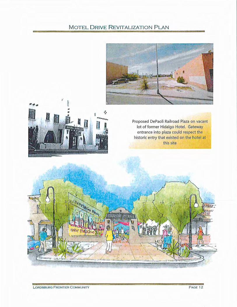
Days!," the former "Tejano Fiesta" and create other cultural events in the downtown area to promote retail businesses." The Motel Drive Revitalization Plan has identified the former site of a portion of the Hidalgo Hotel, now a vacant lot, to be a great site for an outdoor performance and event area. The site could be named "DePaoli Railroad Plaza" in honor of the family who owns the hotel and property.
Create a stronger Public/Private Partnership Environment: • Prepare a Metropolitan Redevelopment Area (MRA) Designation Report for the Revitalization
Plan area (and include the Old Lordsburg High School) and apply to the NM Finance Authority's Local Planning Grant Fund program for funding to prepare the MRA Plan. This is a planning grant for up to $50,000 with no match requirement. Additional tasks in this grant include updating the city's LEDA ordinance (described below) and preparing the Historic District nomination form for submittal to the NM Historic Preservation Division (described below).
• Update the Lordsburg 2012 LEDA Ordinance to include the new legislative amendments language such as adding the "Cultural Facilities" definition, allowing retail development as qualifying uses, and adding "Metropolitan Redevelopment developer" as a qualifying entity.
• Initiate discussions with Union Pacific Railroad on improving a portion of their property along Motel Drive near the Main Street intersection and constructing the transit shelter as proposed in the plan.
• Implement a volunteer-based "Fa~ade Squad" program to improve two of the private buildings facades on Motel Drive. The NM MainStreet program staff can assist with organizing this effort.
• Request the City Code Enforcement staff look into health and safety issues that are present on few of the Motel Drive properties and work with the property owners on bringing them up to code.
• Apply for NM MainStreet "Emerging Community" status. Information on this program can be found at the www.nmmainstreet.org website
• Create a Lordsburg "Railroad Historic District" with assistance and approval of the NM Historic Preservation for tax credit incentives and tourism purposes. Information on this process can be found at the www.nmhistoricpreservation.org website.
• Pursue acquisition of the proposed "DePaoli Railroad Plaza" site either as a donation from the family (with potential tax benefits to the family), or a public/private partnership agreement between the family and the city, or as a land exchange for city surplus property.
Image and Marketing Development: • Create a Wayfinding/lnterpretive signage system for the Railroad District that utilizes vehicular
signage from interstate exits and includes the pedestrian sign age for walking within district.
• Work with NM Tourism to build on the New Mexico True brand and marketing.
L ORDSBURG F RONTIER C OMMUNITY P A G E S
MOTEL DRlVE REVITALIZATION PLAN
Street and Pedestrian Improvements:
• Design and install the 10' wide sidewalks on the ADA sidewalk improvement project currently in process.
• Work with NMDOT on implementing the pedestrian, bike and safety improvements to Motel Drive (aka Railroad Avenue) through NMDOT's STIP process.
• Place the proposed Motel Drive improvement projects on the City's ICIP, pursue Legislative Capital Outlay, and NMDOT funding sources (ATP, TAP, STP, HSIF, Enhancement funds).
Design Solutions • Rename Motel Drive back to Railroad Avenue, the historic street name, due to the lack of
operating motels along the route.
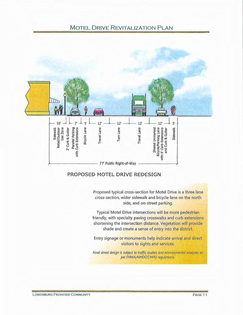
• Improve Railroad Avenue streetscape to increase pedestrian and bicycle safety and to encourage redevelopment along the route. Narrow travel lanes with shared bicycle use, landscaped corner bulb-outs, and pedestrian crosswalks encourage street usage. Reduce the street to one 12' travel lane in each direction with one 12' turn lane in the center of the street. Along the south side curb and gutter provide a 7' for parallel parking and a 5' designated bicycle lane. Create a 12' shared bike lane and parallel parking area on the north side of Railroad Avenue.
• Expand the sidewalk on the north side to t en feet, improving pedestrian walkability and ADA accessibility. Retain maintenance access to the existing waterline under the widened sidewa lk using removable pavers or other materials over the water line instead of concrete.
• Enhance the eastern and western entries on Motel Drive into the plan area with unique public art, landscaping, and signage.
• Create a unique feature on the north side of Railroad Avenue, as one looks north across Motel Drive from the Main Street intersection, to visually reinforce the special character of the district.
• Eliminate the eastbound continuous right turn lane off of Motel Drive onto south Highway 70/Main Street and use this excess right -of-way as an enhanced landscaped entry feature into the district.
• Enhance the entry to Motel Drive (Railroad Avenue) from Main Street to designate arrival at a unique place, to include potentially historic area signage. Special features and landscape on the east and west side of the intersection will attract visitors' attention.
• Enhance the existing NMDOT gateway signage over Main Street just south of Motel Drive as a railroad public art project.
• Utilize the former Hotel Hidalgo site for the "DePaoli Railroad Plaza," an event space with landscaping, and murals or interpretive displays to elaborate on the area's history. The Plaza could be used for events such as a farmers market, Discover Hidalgo County! and the Tejano Fiesta. Outdoor performances or movies would draw residents and visitors to downtown.
L ORDSBURG FRO NTIER COMMUNITY PAGE9
MOTEL DRIVE REVITALIZATION PLAN
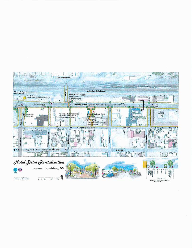
• Create a Multi-Modal Transit shelter for passengers of Amtrak, Greyhound Bus and Corre Camino at the northeast corner of Union Pacific crossing and Railroad Avenue. Include shade, seating and information kiosk.
• Designate a bicycle route between the Elementary and High Schools west of Main Street and the Hidalgo Museum and Fairgrounds using 3'd, Pyramid and 2"d Streets.
• Reintroduce period-style street lighting, as found in photographs from the 1940s.
• Retain historic Ownby Hotel sign on Pyramid Street.
• Develop interpretive signage highlighting Lordsburg's location on the Old Spanish Trail, Bankhead and Broadway of America highways.
These design solutions are depicted on the following site plan and illustrations.
L ORDSBURG F RONTIER COMMUNITY P AGE 10
W.t)f·t~E!#.!~ !hf' ... ~AI~Cia..t-~1·1.!.10
.-- ---- ,-----.-~·~:.
' . . .. 1 . ' ' t ' Soutnom P..:ttto ltvcl.
rM~D HOln OA:\'f lll.Dts:G~ ttCOONA·A
MOTEL DRIVE REVITALIZATION PLAN
10' J l T l 5' L 12' _L 12' _L 12' _L 12' J. 5' .>o: '-QJ .... 0>111 QJ QJ QJ <11 "0 QJ Ill .... -" n;gc <11 c c: c: c: c: c: QJ c: c: QJ ;;; ~ ·- 0 _j ~ _j _'j t: _'j .!:! ~ ~:s~ -" ·- :;: ::l ..... Ill
"' Ill QJ -o::lQJ l,') "' c: <11 iii E iii Ea~c:l.'J "0 0.. cu -QIII oZS a;)( v > .= > c: .s 2 oZS in Vl:::,.:::l () ~ "' :::~ t:~..c I§ ..c =W .... ....
~-E iii 1- 1- "U~.o~ ::l <11 u ~ -.....~.... u 0:: "':::1 N o..u ~~8-o
.r; Vl () i:o :ii ='= ;: coz
~
)'---- ------ 77' Public Right-of-Way - --- - --- )'
PROPOSED MOTEL DRIVE REDESIGN
Proposed typical cross-section for Motel Drive is a three lane cross-section, wider sidewalk and bicycle lane on the north
side, and on-street parking.
Typical Motel Drive intersections will be more pedestrian friendly, with specia lty paving crosswalks and curb extensions shortening the intersection distance. Vegetation will provide
shade and create a sense of entry into the district.
Entry signage or monuments help indicate arrival and direct visitors to sights and services.
Final street design is subj ect to traffic studies and environmental analyses as per FHWA/NMDOT/HPD regulations.
LORDSBURG FRONTIER COMMUNili' PAGE 11
MOTEL DRIVE R EVITALIZATION PLAN
. _,- :: I;
I .. oi
...
L ORDSBURG FRONTIER COMMUNITY
. f •.·
Proposed DePaoli Railroad Plaza on vacant lot of former Hidalgo Hotel. Gateway entrance into plaza could respect the
historic entry that existed on the hotel at this site
P AGE 12
MOTEL DRIVE R EVITALIZATION PLAN
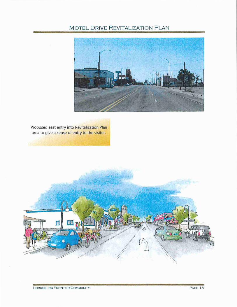
Proposed east ent ry into Revitalization Plan area to give a sense of entry to the visitor.
LORDSBURG FRONTIER C O M MUNITY PAGE 13
MOTEL DRIVE REVITALIZATION PLAN
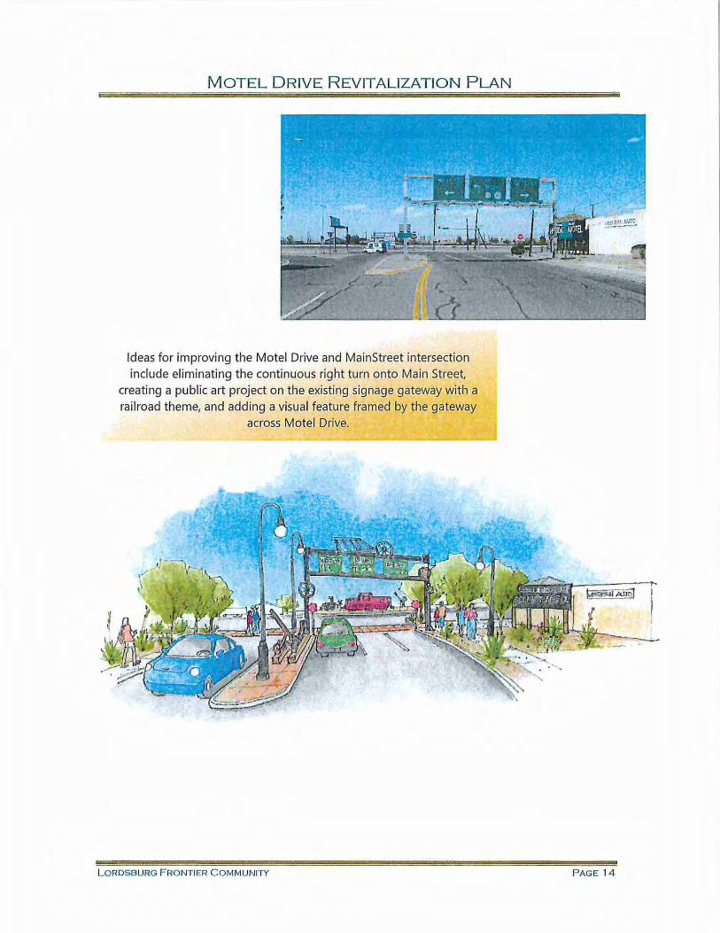
Ideas for improving the Motel Drive and MainStreet intersection include eliminating the continuous right turn onto Main Street,
creating a public art project on the existing signage gateway with a rai lroad theme, and adding a visual feature framed by the gateway
across Motel Drive.
L ORDSBURG F RONTIER COMMUNITY PAGE 14
MOTEL DRIVE REVITALIZATION PLAN
APPENDICES
A. Preliminary cost of Railroad Plaza improvements (does not include land acquisition)
B. ITE MainStreet design guidelines
C. Economic benefits of MainStreets (also called Complete Streets)
L ORDSBURG FRONTIER COMMUNITY PAGE 1 5
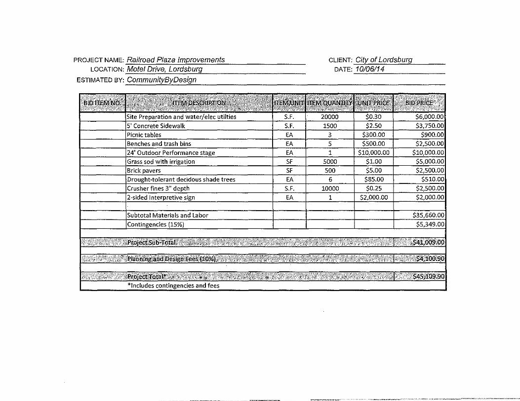
PROJECT NAME: Railroad Plaza Improvements LOCATION: Motel Drive, Lordsburg
ESTIMATED BY: CommunityByDesign
CLIENT: City of Lordsburg DATE: 10106114
Main streets used to be the principal thoroughfares of American towns, where people could find all types of goods and services. They were the center of commercial, social and civic activities. Main streets thrived until the 1960s and 1970s, when largerscale, auto-oriented shopping centers became popular. Many communities now are revitalizing their main streets to return to a traditional small-town mercantile environment or are creating hybrids of traditional and contemporary commercial centers.
The value of today's main streets is summarized in this quote from Portland Metro's Main Street Handbook: "Main streets flourish because they provide a variety of goods and services, a pleasant community environment and efficiency for those who frequent them. When people do their shopping at a main street, they simply accomplish more wi.th less travel, and may find the experience more entertaining."
Creating Quality Main Streets Main streets may be located in any context zone, but are most commonly found in suburban (C-3), general urban (C-4) and urban center (C-5) contexts. They are usually short segments of arterial or collector streets, often only a few blocks in length. They are within a grid or interconnected system of local streets serving the commercial center of town.
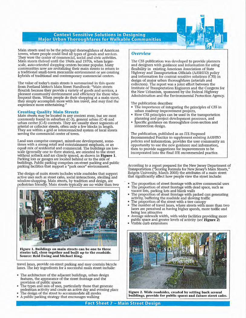
Land uses comprise compact, mixed-use development, sometimes with a strong retail and entertainment emphasis, or an equal mix of residential and commercial. The buildings are lowscale (generally one to three stories), are oriented to the street without setback and are closely spaced, as shown in Figul'e 1. Parking lots or garages are located behind or to the side of buildings. Public parking comprises on-street parking and public parking facilities that support a "park once" environment.
The design of main streets includes wide roadsides that support active uses such as street cafes, social interactions, strolling and window-shopping. Main streets, by tradition and design, are pedestrian friendly. Main streets typically are no wider than two
Figure 1. Buildings on main streets can be one to three stories tall, close together and built up to tbe roadside. Source: Reid Ewing and Jl.fichacl King.
travel lanes, provide on-street parking and may contain bicycle lanes. The key ingredients for a successful main street include:
• The architecture of the adjacent buildings, urban design features, the appearance of the street frontage and the provision of public spaces
• The types and mix of uses, particularly those that generate pedestrian activity and create an active day and evening place
• The design of the street to accommodate all modes • A public parking strategy that encourages walking
Overview
The CSS publication was developed to provide planners and designers with guidance and information for using flexibility in existing American Association of State Highway and Transportation Officials (AASHTO) policy and information for context sensitive solutions (CSS) in design of major urban thoroughfares (arterials and collectors). The report was a joint effort between the Institute of Transportation Engineers and the Congress for the New Urbanism, sponsored by the Federal Highway Administration and the Environmental Protection Agency.
The publication describes: • The importance of integrating the principles of CSS in
urban roadway improvement projects, • How CSS principles can be used in the transportation
planning and project development processes, and • Specific guidance on thoroughfare cross-section and
intersection design.
The publication, published as an ITE. Proposed Recommended Practice to supplement existing AASHTO policies and information, provides the user community an opportunity to use the new !:,'llidance and information, then to provide suggestions for improvements to be incorporated into the final ITE recommended practice.
According to a report prepared for the New Jersey Department of Transportation ("Scoring Formula for New Jersey's Main Streets," Rutgers University, March 2003) the attributes of a main street that significantly affect how people view the street include:
• The proportion of street frontage with active commercial uses • The proportion of street frontage with dead space, such as
vacant lots, parking lots and blank walls • The proportl011 of street frontage with parked cars generating
activity, buffering the roadside and slowing traffic • The proportion of the street with a tree canopy • The number of travel lanes, where streets with more than two
lanes are perceived as having higher speeds, more traffic and being less attractive
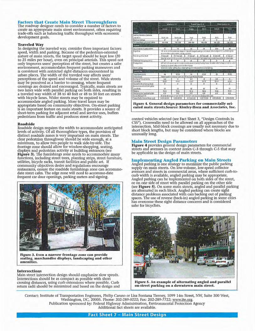
• Average sidewalk width, with wider facilities providing more public space and greater levels of activity (see Figure 2)
• Visible curb extensions
Figure 2. \Vide roadsides, created by setting back several buildings, JJrovide for public SJJaces and future street cafes.
Fact Sheet 7 - Main Street Design
Factors that Create Main Street Thoroughfares The roadway designer needs to consider a number of factors to create an appropriate main street environment, often requiring trade-offs such as balancing traffic throughput with economic development goals.
Traveled Way [n designing the traveled way, consider three important factors: speed, width and parking. Because of the pedestrian-oriented nature ~f main streets, the target speed should be kept low {20 to 25 miles per hour), even on principal arterials. This speed not on!~ improves users' perception of the street, but creates a safer environment, accommodates frequent parking maneuvers and is consistent with restricted sight distances encountered in urban places. The width of the traveled way affects users' perceptions of the speed and volume of the street. Wide streets may he perceived as a barrier to crossing, where frequent crossings ar~ desi~ed and encoura.ged. Typically! main streets are two lanes wide \~1.th parallel parking on both s1des, resulting in a traveled way w1dth of 38 to 40 feet or 48 to SO feet on streets with bicycle lanes. Wider streets may be required to acconu~odate angled parking. ~lore travel lanes may be appropnate based on community objectives. On-street parking is an important feature on main streets. It provides a source of short-term parking for adjacent retail and service uses, buffers pedestrians from traffic and produces street activity.
Roadside Roadside de~i~n requires the width to accommodate anticipated levels of activity. Of aU thoroughfare types, the provision of distinct roadside zones is very important on main streets. The cl~a~ pedestrian throughway should be wide enough, at a mmmmm, to allow two people to walk side-by-side. The frontage zone should allow for window-shopping, seating, displays and pedestrian activity at building entrances (see Figu~c 3) .. The ft.unishings zone needs to accommodate many fun ctions, mcludmg street trees, planting strips, street furn iture, utilities, bicycle racks, transit facilities and public art. If community objectives desire and regulations encourage restaurants, ensure the roadside ftnnishings zone can accommodate street cafes. The edge zone will need to accommo-date frequent car door openings, parking meters and signing.
Figure 3. Even a narrow frontage zone can provide seating, merchandise displays, landscaping and other amenities.
Intersections Mairi street intersection design should emphasize slow speeds. Intersections should be as compact as possible with short crossing distances, using curb extensions where possible. Curb return radii should be minimized and based on the design and
Figure 4. General dcsi&'ll parameters £or commercially oriented main streets.Source: I<imley-Horn and Associates, Inc.
control vehicles selected (see Fact Sheet 3, "Design Controls in CSS"). Crosswalks need to be allowed on all approaches of the intersection . Mid-block crossings are usually not necessary due to short block lengths, but may be considered where blocks are unusually long.
Main Street Design Parameters Figure 4 provides general design parameters for commercial streets and avenues in context zones C-3 through C-5 that may be applicable in the design of main streets.
Implementing Angled Parking on Main St.-eets Angled parking is one strategy to ma;xirnize the public parking supply on main streets. On low-volume, low-speed collector avenues and streets in commercial areas, where sufficient curb-tocurb width i~ available,. angled parking may be appropriate. Angled parkmg can be Implemented on both sides of the street, or on one side of street with parallel parking on the other side (see Figure 5). On some main streets, angled and parallel parking a~e alternated in each block. Angled parking can create sight distance problems associated with cars backing out of parking spaces. The use of reverse (back-in) angled parking in some dties has overcome these sight distance concerns and is considered safer for bicyclists.
Figure 5. An example of alternating angled and parallel on-street parking on a downtown main street.
Contact: Institute of Transp.ortation Engineers, Philip Caruso or Lisa Fontana Tierney, 1099 14th Street, NW, Suite 300 West, . v~aslungton, DC, 20005. Phone: 202-289-0222; Fax: 202-289-7722; www.ite.org.
Publication sponsored by: Federal Highway Administra tion, Environmental Protection Agency Additional fact sheets arc available.
Fact Sheet 7 - Main Street Design
The Benefits of Complete Streets 7
•
Complete Streets are designed and
operated so tl1ey work (or all
users- pedestrians, bicyclists,
moto;ists and transit riders o( all
ages and abilities. Communities !hat
adopt complete streets policies are
asking transportation planners and
engineers to consistently design and
alter the rigllt-o(-way with all users
ill mind. Contact the National
Complete Streets Coalition
(www.completestreets.arg) to
leam about tl1e diverse groups
working together to enact complete
streets policies across the country!
Complete Streets
Spark Economic Revitalization
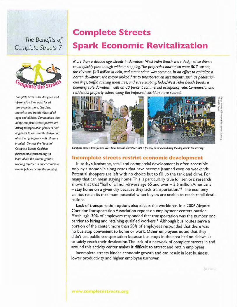
More than a decade ago, streets in downtown West Palm Beach were designed so drivers could quickly pass though without stopping. Tile properties downtown were 80% vacant, the city was $10 million in debt, and street crime was common. In an effort to revitalize a barren downtown, the mayor looked first to transportation investments, such as pedestrian crossings, traffic calming measures, and streetscaping. Today, West Palm Beach boasts a booming, safe downtown with an 80 percent commercial occupancy rate. Commercial and residential property values along tile improved corridors have soared. 1
Complete streets transformed West Palm Beacll's downtown into a friendly destination during the day, and In the evening.
Incomplete streets restrict economic development In today's landscape, retail and commercial development is often accessible
only by automobile along roads that have become jammed even on weekends. Potential shoppers are left with no choice but to fill up the tank and drive. For many, that can mean staying home. This is particularly true for seniors; research shows that that "half of all non-drivers age 65 and over- 3.6 million Americans -stay home on a given day because they lack transportation."2 The economy cannot reach its maximum potential when buyers are unable to reach retail destinations.
Lack of transportation options also affects the workforce. In a 2006 Airport Corridor Transportation Association report on employment centers outside Pittsburgh, 30% of employers responded that transportation was the number one barrier to hiring and retaining qualified workers.3 Although bus routes serve a portion of the center, more than 50% of employees responded that there was no bus stop convenient to home or work. Other employees noted that they didn't use public transportation because bus stops in the area had no sidewalks to safely reach their destination. The lack of a network of complete streets in and around this activity center makes it difficult to attract and retain employees.
Incomplete streets hinder economic growth and can result in lost business, lower productivity, and higher employee turnover.
www.~mplete1tf'C!ots.org
The Benefits of Complete Streets 7
•
Complete Streets Steeri ng
Committee Organizations
AARP
Alliance for Bik1ng and Walking
America Bikes
America Walks
American Council of the Blind
American Planning Association
American Public
Transportation Association
American Society of
Landscape Architects
Association of Pedestrian and
Bicycle Professionals
Crty of Boulder
HNTB
Institute ofTransportltion Engineers
League of American Bicycli~ts
McCann Consulnng
National Association of Area Agencies
on Aging
National Center for Bicycling
and Walking
Safe Routes to School National
Pnrtnersh!p
Smart Growth America
SvR Design Company
National Complete
Streets Coalition
1707 L St NW. Suite I 050
Washington, DC 20036
(202) 207-3355
Complete Streets Spark Economic Revitalization
Complete Streets create viable, liveable communities Creating infrastructure for non-motorized transportation and lowering
automobile speeds by changing road conditions can improve economic conditions for both business owners and residents. When Valencia Street in San Francisco's Mission District slimmed its traffic lanes to slow down cars and accommodate other users, merchants reported the street changes enhanced the area. Nearly 40 percent of merchants reported increased sales, and 60 percent reported more area residents shopping locally due to reduced travel time and convenience. Overall, two-thirds of respondents described the increased levels of pedestrian and bicycling activity and other street changes improved business and sales.4 A network of
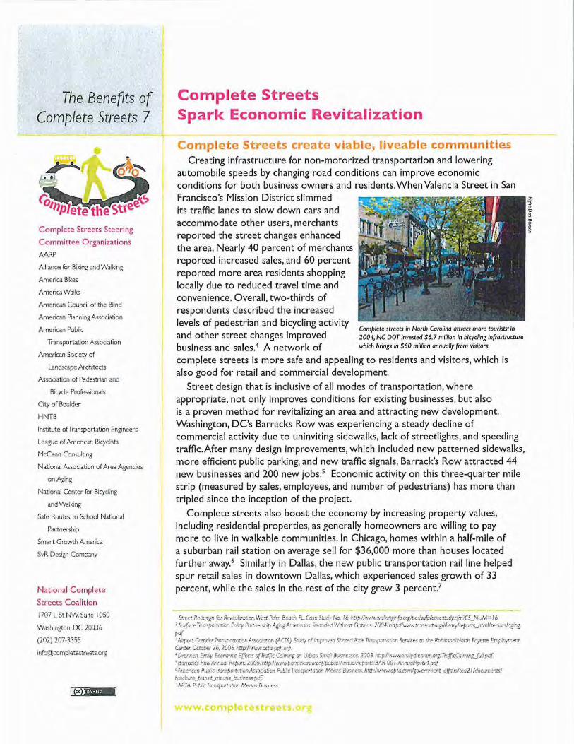
Complete streets in North Carolina attract more tourists: in 2004, NC DOT Invested $6.7 million in bicycling infrastructure which brings in $60 mil/ian annually (rom visitors.
complete streets is more safe and appealing to residents and visitors, which is also good for retail and commercial development.
Street design that is inclusive of all modes of transportation, where appropriate, not only improves conditions for existing businesses, but also is a proven method for revitalizing an area and attracting new development. Washington, DC's Barracks Row was experiencing a steady decline of commercial activity due to uninviting sidewalks, lack of streetlights, and speeding traffic. After many design improvements, which included new patterned sidewalks, more efficient public parking, and new traffic signals, Barrack's Row attracted 44 new businesses and 200 new jobs.5 Economic activity on this three-quarter mile strip (measured by sales, employees, and number of pedestrians) has more than tripled since the inception of the project.
Complete streets also boost the economy by increasing property values, including residential properties, as generally homeowners are willing to pay more to live in walkable communities. In Chicago, homes within a half-mile of a suburban rail station on average sell for $36,000 more than houses located further away.6 Similarly in Dallas, the new public transportation rail line helped spur retail sales in downtown Dallas, which experienced sales growth of 33 percent, while the sales in the rest of the city grew 3 percent?
S:net R~Je<·kn (or Re1 t•JIIZtl~on. West Pafrr. Bec<ll. FL (<Jse St.rit No. I 6./rtt.p /1,,.,-,.,di<JnR•t 'o a·glpecsafe!wO£>Cltly.cfin?C"S_NUIA= 16 l s~rfc;ce Trw .spcti<J'uon Pol.cy Pan:nt!Snip.Ag.ng kn•,rms SU1!odr:J 1Nrl.o.l! 0 /)MOS 200•. hup:/\IWII!fUOS,cto-gflrb:arylteports.J>rmllrenroroogmg t<i{ "A·vo•: U>•r . .:arirar~pwO!JCr.AssroaLon (ACTA). Sv:i; c[ rr.tr:I•e:i 5I ~red R.:ie Trar.sp<.rtcL"n Se"1"<e5 to u·e Rob:nso'lil'iotdl Fafi'Ue Emp!ow:em Cemer Ocw!;er 76, JC05 lrrcp:lhwNocta-pglr O'i 'Dn:r.ren. &r.::y Econom.c E{'"ec!s o{Tta{i"c U> '"""l c• U:bm S•"'o' 8JS-resse!. 2003 1-.upJ!.wtll.u•.·.yd·er.r.er.o:gr Tm{f cCc'm·n&.]u'i :xt{ ' B,ur.c.:'s Rcw ArJI.al R~po•t i.C05./otcpli'.';.-ntl.<lt~.r""wo·~ 'f'Jb..~ ftrrwa P£ro<~: BAR-DO 1-Ar·:ua:Rpm 4 pdf ' 1-rr.enccn Prlb..c Tram;pD'!·>tcn Jlssoda~on. Pub •• c T'1J•sp<•~atcn 1/eors ibs r.ess. ilttp·/llw:,l.cp•a.cmnlgoll!rrJm'nt_a{fairslteo21/docLrrenrsl b·c&.;•e_tFms.r_mf!Oos_bu< ness.p.:f. - APTA Pjbi>e Tiunsp.;•wtion Ncons B'osness
www.comphUc:ut,-.,eu.orx