Embed Size (px)
Citation preview
`
MOUNTAIN VISTA SUBAREA PLAN Original Plan Adopted March 16, 1999 Update of Plan Adopted September 15, 2009
Advance Planning 281 North College Avenue Fort Collins, CO 80524 970-221-6376 fcgov.com/advanceplanning For additional copies, please visit our website, or contact us using the above information.
MOUNTAIN VISTA SUBAREA PLAN
CREDITS i
CREDITS FORT COLLINS CITY COUNCIL Doug Hutchinson, Mayor Kelly Ohlson, Mayor Pro Tem, District 5 Ben Manvel, District 1 Lisa Poppaw, District 2 Wade Troxell, District 3 David Roy, District 4 Aislin Kottwitz, District 6 Diggs Brown, District 6 (former) PLANNING & ZONING BOARD Brigitte Schmidt, Chair Gino Campana Jennifer Carpenter David Lingle Ruth Rollins Andy Smith Butch Stockover James Wetzler (former) TRANSPORTATION BOARD Gary Thomas, Chair Olga Duvall Sara Frazier Bill Jenkins John Lund Kip McCauley Shane Miller Edmund Robert Sid Simonson Garry Steen Scott VanTatenhove CITY LEADERSHIP Darin Atteberry, City Manager Diane Jones, Deputy City Manager Jeff Scheick, Director of Planning, Development
& Transportation Mark Jackson, Transportation Group Director Joe Frank, Advance Planning Director Kathleen Bracke, Transportation Planning &
Special Projects Director
CREDITS CITY STAFF Pete Wray, Senior City Planner,
Co-Project Manager Matt Wempe, Transportation Planner,
Co-Project Manager Megan Woodman, City Planner Matt Baker, Street Oversizing Program Manager Josh Birks, Economic Advisor Craig Foreman, Park Planning & Development
Director Denise Weston, Senior Transportation Planner
(former) Susan Hayes, Civil Engineer III Becca Henry, Urban Design Specialist Susan Joy, Civil Engineer I Dana Leavitt, Environmental Planner Laura O’Gan, GIS Programmer/Analyst Steve Olt, City Planner Sue Paquette, Utilities Water Engineering &
Field Operations, Special Projects Manager Timothy Wilder, Senior City Planner CONSULTANT TEAM Design + Planning at AECOM Bruce Meighen, Principal-in-Charge Megan Moore, Associate LSA Associates, Inc. Ray Moe, Principal Sean McAtee, Transportation Felsburg, Holt & Ullevig Rich Follmer, Transportation Dale Tischmak, Noise Analysis Economic and Planning Systems, Inc. Dan Guimond, Principal Michael Gaughan, Associate MEMBERS OF THE PUBLIC Many property owners, residents and members of the public participated in this planning effort. Thank you to all who contributed to this plan.
MOUNTAIN VISTA SUBAREA PLAN
ii TABLE OF CONTENTS
TABLE OF CONTENTS Plan Foundations ..............................1 Introduction .......................................... 1 Purpose of Updating the Mountain Vista Subarea Plan ......................................... 1
Mountain Vista Subarea.......................... 3 Public Process........................................ 3 Related Plans ........................................ 4
City Plan ........................................... 4 Transportation Master Plan ..................... 5 Transit Strategic Plan ............................ 6 Upper Cooper Slough Master Plan.............. 6 Parks & Recreation Policy Plan................. 6 Northside Neighborhoods Plan.................. 6 I-25 Subarea Plan ................................. 7
How to Use This Plan ............................... 7 Existing Conditions and Analysis ..........9 Introduction .......................................... 9 Existing Conditions .................................. 9
Land Use ........................................... 9 Transportation ...................................14
Framework Plan Objectives ......................16 Land Use ..........................................16 Transportation ...................................17 Open Lands .......................................17
Analysis ..............................................18 Travel Demand Modeling .......................18 Air Quality ........................................18 Noise...............................................18 Land Use Demand Market Analysis ............19 Framework Plan Alternatives ..................19
Development Factors ..............................20 Existing Ownership and Land Use ............20 Adjacent Residential Neighborhoods .........20 Existing Railroad Switching Yard ..............20 Stormwater Drainage ...........................20 Existing Ditches and Canals ....................21 Natural Areas.....................................21 Trails...............................................21 Views ..............................................21 Gateways..........................................21 Future Employment District....................21 Overhead Power Lines ..........................23 Historic Properties...............................23
TABLE OF CONTENTS Vision ...........................................25 Introduction ........................................ 25 Plan Vision .......................................... 25
Neighborhoods................................... 25 Community Commercial District.............. 25 Employment & industrial Districts ........... 26 Transportation System ......................... 26 Natural Areas and Open Lands................ 26 Community Appearance ....................... 26
Framework Plan ..............................27 Introduction ........................................ 27 Land Use ............................................ 27
Key Issues ........................................ 27 2009 Framework Plan Land Uses ............... 30
Mixed-Use Neighborhoods ..................... 31 Transportation ..................................... 36
Key Issues ........................................ 37 Transportation Network Changes............. 39 Street Design Recommendations ............. 41 De Facto Truck Route Concerns .............. 41
Open Lands ......................................... 43 Park Facilities ................................... 43
Stormwater ......................................... 44 Upper Cooper Slough ........................... 44 Dry Creek......................................... 44
Principles and Policies ......................45 Introduction ........................................ 45 Principles and Policies ............................ 45
Land Use.......................................... 45 Economic Sustainability and Development .................................... 46 Transportation .................................. 47 Community Appearance and Design ......... 49 Housing ........................................... 49 Environment ..................................... 49 Natural Areas and Open Lands................ 50 Growth Management ........................... 50
MOUNTAIN VISTA SUBAREA PLAN
CREDITS iii
Implementation Recommendations...... 51 Introduction .........................................51 Implementation Actions Since the 1999 Plan Adoption............................51
Amendments to Existing City Maps ...........51 Land Use Code ...................................51 Stormwater .......................................51 Off-Street Trails and Parks.....................51 Poudre School District ..........................51
Implementation Actions Concurrent with Plan Adoption.................................52 Implementation Actions After Plan Adoption .......................................52
REZONINGS........................................52 Gateway Corridor Design Standards ..........52 Mountain Vista/North College Enhanced Travel Corridor Plan ................52
Future Infrastructure Improvement Projects and Financing ............................53
Transportation Projects ........................53 Stormwater Projects ............................53 Funding Options..................................53 Key Adequate Public Facilities Projects .....54
Appendices ................................... 61 A. Summary of Open House Comments B. Land Demand Analysis and Framework Map Alternatives C. Greenhouse Gas and Air Quality Impacts Memo D. Traffic Noise Evaluation Report E. Truck Bypass Route Analysis
MOUNTAIN VISTA SUBAREA PLAN
iv TABLE OF CONTENTS
TABLE OF FIGURES Figure 1 – Context Map ........................ 2
Figure 2 - 1999 Framework Plan Land Uses ................................... 9
Figure 3 – Current Structure Plan Map .....10
Figure 4 – Current Zoning Map...............11
Figure 5 - Future Park Sites..................12
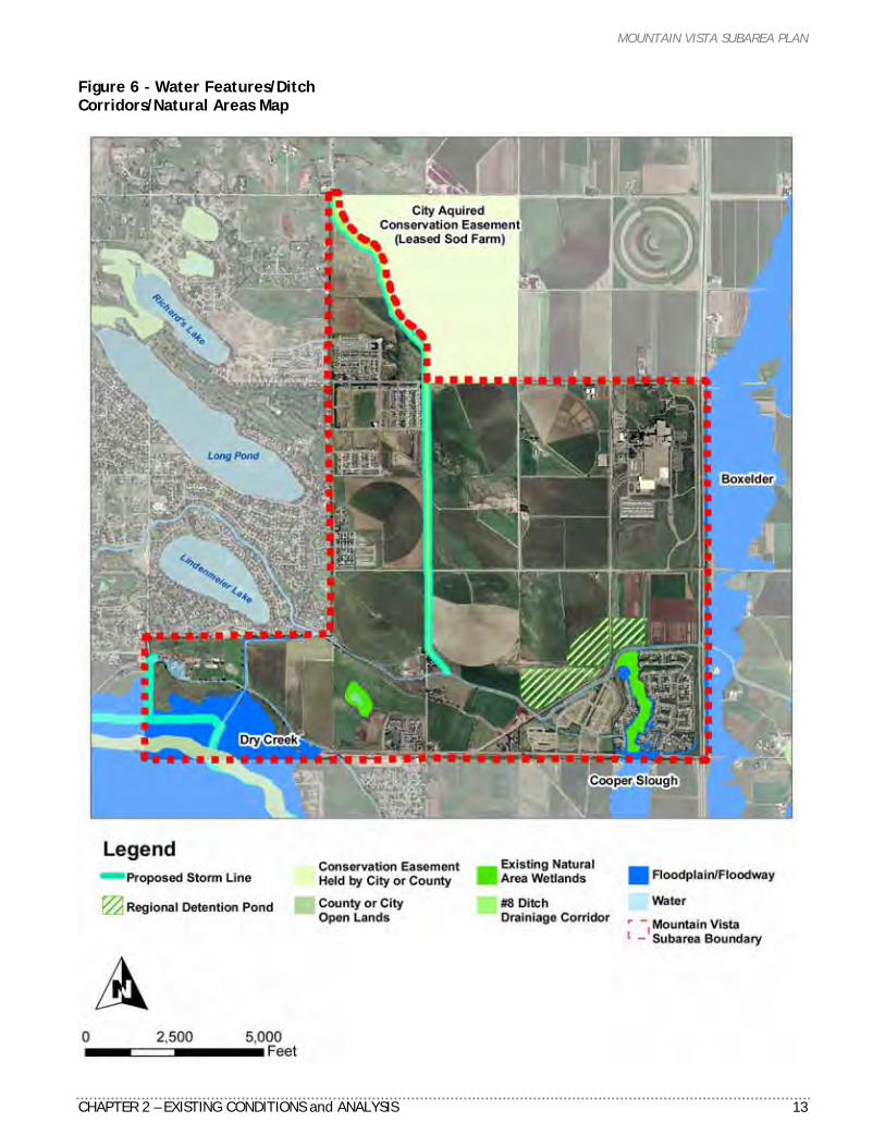
Figure 6 - Water Features/Ditch Corridors/Natural Areas Map ...........13
Figure 7 – Existing Master Street Plan......15
Figure 8 – Travel Demand Modeling ........18
Figure 9 – Development Factors Map .......22
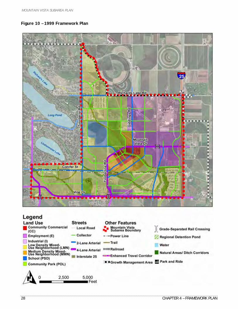
Figure 10 – 1999 Framework Plan...........28
Figure 11 – 2009 Framework Plan...........29
Figure 12 – Framework Plan Map Comparison................................30
TABLE OF FIGURES Figure 13 –Community Commercial
District Concept.......................... 32
Figure 14 – Community Commercial District Diagram.......................... 33
Figure 15 – Enhanced Travel Corridor Examples .................................. 38
Figure 16 – Proposed Master Street Plan ................................ 42
Figure 17 – Priority of Transportation Improvements ............................ 56
Figure 18 – Adequate Public Facilities Projects.................................... 56
Figure 19 – Capital Improvement Projects.................................... 57
Figure 20 - Capital Improvement Projects Map.............................. 58
Figure 21 – 1999 Implementation Action Plan – Completed................ 59
Figure 22 – 2009 Implementation Action Plan................................ 60
MOUNTAIN VISTA SUBAREA PLAN
CHAPTER 1 – PLAN FOUNDATIONS 1
C H A P T E R 1
PLAN FOUNDATIONS
Introduction A subarea plan is a policy document for a specific area prepared by a city to implement a community-based vision. In Fort Collins, a subarea plan provides a framework of community-based principles, policies and implementation strategies recommended by the Planning & Zoning and Transportation Boards and adopted by City Council. The Mountain Vista Subarea Plan represents a strong relationship between land use and transportation, and directly links to the Transportation Master Plan and City Plan (the comprehensive plan for Fort Collins). Thus, the Mountain Vista Subarea Plan is an element of City Plan and provides more detailed policy direction for future implementation decisions. This plan is a statement of how the community views itself, what the vision is for the future, and what actions are required to implement this vision.
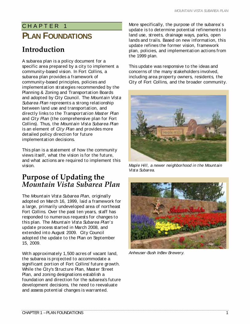
Purpose of Updating the Mountain Vista Subarea Plan The Mountain Vista Subarea Plan, originally adopted on March 16, 1999, laid a framework for a large, primarily undeveloped area of northeast Fort Collins. Over the past ten years, staff has responded to numerous requests for changes to this plan. The Mountain Vista Subarea Plan’s update process started in March 2008, and extended into August 2009. City Council adopted the update to the Plan on September 15, 2009. With approximately 1,500 acres of vacant land, the subarea is projected to accommodate a significant portion of Fort Collins' future growth. While the City's Structure Plan, Master Street Plan, and zoning designations establish a foundation and direction for the subarea's future development decisions, the need to reevaluate and assess potential changes is warranted.
More specifically, the purpose of the subarea’s update is to determine potential refinements to land use, streets, drainage ways, parks, open lands and trails. Based on new information, this update refines the former vision, framework plan, policies, and implementation actions from the 1999 plan. This update was responsive to the ideas and concerns of the many stakeholders involved, including area property owners, residents, the City of Fort Collins, and the broader community.
Maple Hill, a newer neighborhood in the Mountain Vista Subarea.
Anheuser-Bush InBev Brewery.
MOUNTAIN VISTA SUBAREA PLAN
2 CHAPTER 1 – PLAN FOUNDATIONS
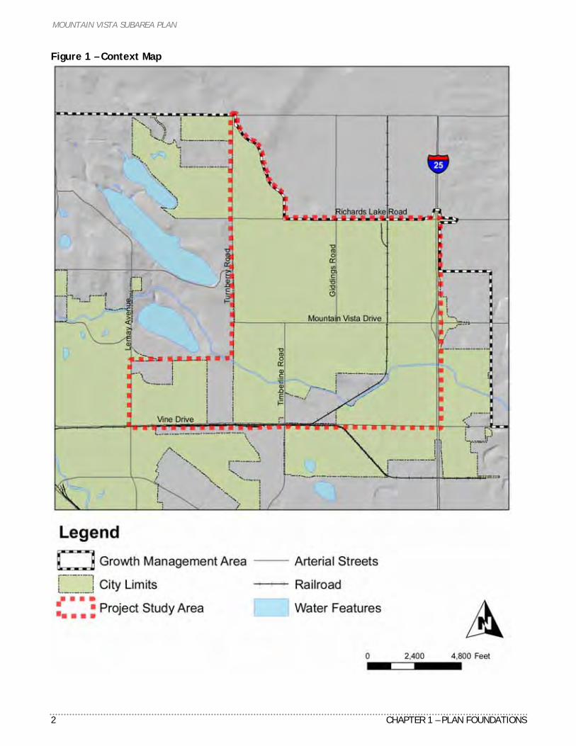
Figure 1 – Context Map
MOUNTAIN VISTA SUBAREA PLAN
CHAPTER 1 – PLAN FOUNDATIONS 3
MOUNTAIN VISTA SUBAREA The Mountain Vista subarea is located in the northeast quadrant of Fort Collins, bordered by Richards Lake Road to the north, Interstate 25 to the east, Vine Drive to the south, and Turnberry Road and Lemay Avenue to the west (see Figure 1 on previous page). Historically agricultural in use, a large portion of the subarea remains undeveloped, with the exception of four residential neighborhoods and the Anheuser-Busch InBev (ABI) brewery. Until recently, the subarea experienced less pressure to develop than other areas of the city. Recent economic conditions aside, the northeast quadrant of the city will provide the long-term growth area of the community. This is due to a limited supply of buildable vacant land available throughout the Fort Collins’ Growth Management Area (GMA). Most of the land within the subarea was annexed in the 1980s, but a few parcels remain outside of city limits. These parcels are expected to annex at the time of development.
Public Process The planning process for the Plan update included extensive public involvement from property owners within the project area, Anheuser-Busch InBev, Poudre School District (PSD), service providers, Burlington Northern Santa Fe Railway, area residents, Boards and Commissions, and City Council. The planning process was divided into three main sections. The first phase (March 2008 - August 2008) primary tasks included identifying background information associated with the project start up. The project team identified key issues, existing conditions and plan objectives. A reevaluation of the original vision, and policies was conducted to assess refinement of this foundational language. The team set up meetings with individual property owners and provided updates to Boards and Commissions during this phase. Phase II (August 2008 - March 2009) focused on design. Travel demand modeling by the consultant team determined future traffic volumes and street classifications for comparison between the 1999 and 2009 street networks. A market analysis was conducted to
assess support for the amount of land use designations in the subarea. In October 2008, three framework plan alternatives were developed to compare different scenarios for land use, street patterns, open lands and other public facilities. In February 2009, three plan map options were developed to further test land use and transportation choices. Based on public feedback, the project team integrated the successful elements of each alternative into a single draft framework plan.
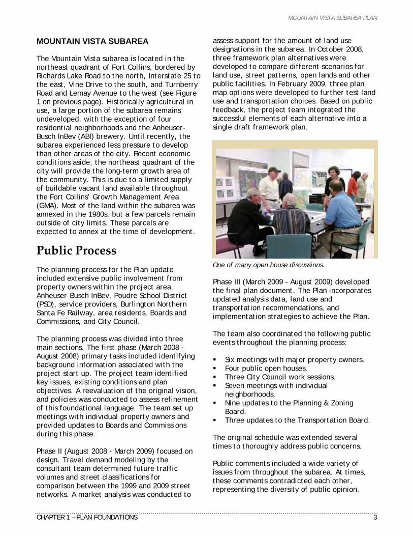
One of many open house discussions. Phase III (March 2009 - August 2009) developed the final plan document. The Plan incorporates updated analysis data, land use and transportation recommendations, and implementation strategies to achieve the Plan. The team also coordinated the following public events throughout the planning process: Six meetings with major property owners. Four public open houses. Three City Council work sessions. Seven meetings with individual
neighborhoods. Nine updates to the Planning & Zoning
Board. Three updates to the Transportation Board.
The original schedule was extended several times to thoroughly address public concerns. Public comments included a wide variety of issues from throughout the subarea. At times, these comments contradicted each other, representing the diversity of public opinion.

MOUNTAIN VISTA SUBAREA PLAN
4 CHAPTER 1 – PLAN FOUNDATIONS
Questions and comments heard most often included: What is the timing of development? Why does the City want to co-locate the
future park with school facilities? What options are available for lower
residential density? What is an appropriate size buffer between
the Brewery and residential uses? How large will the commercial area be and
what services will it offer? Plan for off-street bicycle and pedestrian
trails. Do/do not extend Turnberry Road south to
Vine Drive. Do/do not extend Conifer Street to the east. Maintain direct access to I-25. How will the grade-separated crossings
function (overpass vs. underpass)? Re-aligned Vine Drive and its connection to
Mountain Vista Drive/I-25 interchange may become a de facto truck route.
Related Plans The Mountain Vista Subarea Plan is only one of many plans that have been adopted by the City. Each subarea plan reinforces the concepts and policies of broader comprehensive plans, ensuring that one, cohesive vision is established for the community. The following is a review of previously adopted plans that influenced the decisions made for the Mountain Vista subarea. CITY PLAN In 2004, the City of Fort Collins updated City Plan, a forward-thinking, 20-year plan for the community, premised on the following concepts: discouraging sprawl while encouraging infill and compact development, establishing community separators, interconnecting many multi-modal transportation options, promoting diversity of housing options, and advocating high quality development. City Plan speaks to four basic place types, which comprise the structure of the community: neighborhoods, districts, corridors and edges. According to City Plan, “the organization of these places – their ‘structure’ – gives meaning and form to our community’s vision. These are
not intended as single-use ‘zones’ in the sense of traditional land use zoning patterns, but as distinct and diverse places that contain mixtures of uses and activities.” The Mountain Vista subarea contains all four place types: neighborhoods, districts, corridors, and edges. Mountain Vista as a Neighborhood City Plan envisions neighborhoods as the dominant and most important areas within Fort Collins. Neighborhoods are to be walkable and connected, include a mix of housing types, and include destinations within walking distance, such as schools, parks, neighborhood shopping, employment and civic areas. Mountain Vista is one of the last growth areas of the community and is planned to accommodate a significant portion of new residential development in the Low Density Mixed-Use Neighborhood (LMN) and Medium Density Mixed-Use Neighborhood (MMN) zones. LMN is expected to be the predominant form of new housing development, with a minimum density of 5 dwelling units per acre. These neighborhoods will consist of a mix of detached homes on small and average size lots, townhomes, duplex units and manufactured housing. MMN, in relation, is planned to accommodate a minimum density of 12 dwelling units per acre with the same mix of housing types. These neighborhoods should be located near Community Commercial Districts and transit routes. The principles and policies pertaining to neighborhoods focus on promoting these areas as integral parts of the broader community structure, integrating open lands, parks, greenways, and design policies emphasizing creativity, diversity and individuality. Mountain Vista as a District There are seven types of districts identified in City Plan, three of which are planned for the subarea; Community Commercial, Employment, and Industrial districts. Districts are larger than an individual neighborhood and are important destinations for living, working, shopping and playing. The concepts for each are defined as follows: Community Commercial District (CCD) “These community-wide destinations are the hubs of a high-frequency transit system offering
MOUNTAIN VISTA SUBAREA PLAN
CHAPTER 1 – PLAN FOUNDATIONS 5
retail, offices, services, small civic uses and higher density housing. The physical environment will promote walking, bicycling, transit use and ridesharing, as well as provide a high quality urban life for residents. Vertical mixed-use (multi-story buildings) will be encouraged with housing and/or offices located above ground-floor retail and services.” Employment District (ED) “Employment Districts are locations for basic employment uses, including light manufacturing, offices, corporate headquarters, and other uses of similar character. These districts will also include a variety of complementary uses, such as residential, business services, convenience retail, child care and restaurants. They will be designed to encourage non-auto travel, car- and van-pooling, and transit use, and have an attractive appearance – allowing them to locate adjacent to residential neighborhoods.” Industrial District (ID) “These districts are intended to provide a location for a variety of work processes such as manufacturing, machine shops, warehouses, outdoor storage, and other uses of similar character.” Industrial districts do not have as extensive design standards and, therefore, should be located away from, or adequately buffered from, residential neighborhoods and linked to the city-wide transit system.” Mountain Vista as a Corridor Corridors are intended to be the linking elements of the community, providing mobility between and among districts. This subarea contains three corridor types: Transportation, Enhanced Travel, and Water. Transportation corridors are based on existing and planned street corridors. City Plan states, “Transportation corridors are developed primarily to increase mobility, provide transportation options, enhance the efficiency and aesthetics of the pedestrian/transit interface, and accommodate the flow of goods and people.” Conifer Street and Timberline Road are identified as Enhanced Travel Corridors (ETC) feeding into this subarea. This type of corridor is intended to be developed “to provide multi-
modal connections between two or more major activity centers. ETCs promote safe, convenient, and comfortable access to high frequency transit service and bicycle and pedestrian facilities. ETCs are multi-modal in nature and emphasize wide sidewalks, bike lanes on designated routes, transit stops, and parking facilities.” City Plan’s principles and policies support integrated planning between land use and the transportation network, assuring the highest composite level of service (LOS) among the various modes of service along the corridors, and advocating for facility design to match surrounding development to create pedestrian-scale urban design. Water corridors contain natural and man-made drainageways, maintain wildlife habitat, and provide trails/paths for recreation use. The corridors found in this subarea are the Upper Cooper Slough, the Larimer and Weld Canal, No. 8 Outlet Ditch, and their connections to the natural areas. Principles and policies support adequate buffering of these corridors while still encouraging design to include a trail/path system connecting to open lands and/or parks. Mountain Vista as an Edge Edges form the boundaries for the community for the next 20 years and beyond. This plan’s eastern boundary establishes an edge between Fort Collins Growth Management Area (GMA) and unincorporated Larimer County, and future Timnath development, bordered by I-25. This plan’s northern boundary and GMA forms an edge between Larimer County, and planned community separator between the Town of Wellington. TRANSPORTATION MASTER PLAN A companion document to City Plan is the Transportation Master Plan (TMP). The TMP defines the long-term transportation system accommodating the future needs of Fort Collins. The TMP also provides policy direction for how decisions regarding the implementation of the transportation system should occur. The TMP also includes the City’s Capital Improvements Plan. It identifies priorities for implementing projects to meet short-term deficiencies while
MOUNTAIN VISTA SUBAREA PLAN
6 CHAPTER 1 – PLAN FOUNDATIONS
working towards the ultimate transportation system for the community. The Master Street Plan (MSP) is a map-based guide for the development of the future street network in Fort Collins and the Growth Management Area. First implemented and adopted in 1981, the MSP reflects the functional classification (i.e. arterial, collector, etc.) of the City’s ultimate street network. The MSP also provides a reference for planning and layout of key transportation and circulation connections. TRANSIT STRATEGIC PLAN The Transit Strategic Plan specifies how Transfort, the City's public transit service, will transition to a grid-based system. Specifically, the TSP calls for improved service along Fort Collins' Enhanced Travel Corridors, including the Mason Corridor, Timberline Road, Harmony Road, and realigned Vine Drive to link this subarea with North College Avenue and downtown. UPPER COOPER SLOUGH MASTER PLAN The Upper Cooper Slough Drainage Master Plan, completed in June 2006, addresses flood hazards and necessary improvement projects for the southern portion of the Upper Cooper Slough Basin located within Fort Collins’ Growth Management Area. In 1981 and 2002, the hydrology of the basin was studied as part of the Boxelder Creek/Cooper Slough watershed by the City of Fort Collins and Larimer County. In 1984, in conjunction with development of the Anheuser-Busch InBev brewery, the company prepared a drainage master plan for their portion of the basin. The 2003 update to the City’s stormwater master plan adopted improvements for the Lower Cooper Slough Basin. The improvements recommended by the 2006 Upper Cooper Slough Drainage Master Plan were developed to provide cost-effective solutions to mitigate existing flood damages and alleviate the potential for future damages caused by new development. All improvements identified in the Upper Cooper Slough Drainage Master Plan are located within the Mountain Vista subarea.
PARKS & RECREATION POLICY PLAN An update to the Parks & Recreation Policy Plan was adopted in February 2009 to: Assess the park and recreation needs of the
Fort Collins community. Evaluate the City’s current services. Provide clear and achievable
recommendations to deliver the level of service needed to meet the community’s changing needs for the next ten years.
The recommendations provide the basis for the off-street trail network in this plan. Citizens specifically identified the need for new parks and facilities in northeast Fort Collins. There are six parks planned within this subarea, and the land for three neighborhood parks is already acquired. Land acquisition for the future Community Park is still needed. Land In addition to parks and recreation facilities, long-term trail priorities (2014-2018) include completing work on the northeast trail system. NORTHSIDE NEIGHBORHOODS PLAN The Northside Neighborhoods Plan (NNP) adopted January 18, 2005, overlaps the Mountain Vista subarea to the southwest. The NNP recommendations for street alignments were coordinated based upon the recommendations set forth in the 1999 Mountain Vista Subarea Plan. The Vine Drive and Lemay Avenue
realignments are supported to alleviate traffic issues for the area; the NNP recommends both streets be classified as 4-lane arterials (existing Vine Drive will remain two lanes).
The NNP supports the recommendation made in the 1999 Mountain Vista Subarea Plan to realign Lemay Avenue to the east of the Via Lopez/San Cristo neighborhood. A grade-separated crossing is also recommended to solve current access and congestion problems due to rail traffic. The NNP supports an underpass to reduce visual and noise impacts to the neighborhoods. The final decision as to whether the crossing will be above or below grade will not be decided
MOUNTAIN VISTA SUBAREA PLAN
CHAPTER 1 – PLAN FOUNDATIONS 7
until development and the financial resources are available.
The existing alignment of Lemay/9th Avenue will remain a 2-lane street when the realignment occurs, allowing pedestrian and bike connections between Alta Vista and Andersonville. The street will end in a cul-de-sac south of the railroad tracks. The NNP recommends maintaining a pedestrian and bicycle connection across the railroad tracks. This decision will be made by the Colorado Public Utility Commission with input from Burlington Northern Santa Fe Railway and the City of Fort Collins.
I-25 SUBAREA PLAN The I-25 Subarea Plan focuses on the area located west of I-25 from around the Prospect Road interchange on the south, to County Road 52 on the north, and County Road 5 on the east. The Mountain Vista subarea was included in this planning effort. Specific policies and goals were developed, and included: Policy I-25-LU-2.1 Subarea employment and industrial districts will provide sufficient areas to accommodate long-term employment growth, and will establish appropriate transitions between employment uses and adjacent residential areas. Policy I-25-T-1.1 The subarea’s transportation system will support the development of interconnected regional and local transit, bicycle connections and an integrated pedestrian system. Policy I-25-T-1.2 The subarea’s roadway system will include a network of roadways parallel to I-25 designed for local trips, as needed to support subarea land use activities, and discouraging dependency on I-25 for local trips. Policy I-25-CAD-1.1 Development in the subarea will provide for attractive gateways to Fort Collins from its I-25 interchanges and overpasses at Harmony Road, Prospect Road, Mulberry Street, Vine Drive, Mountain Vista Drive, Carpenter Road, and their arterial corridors leading in from I-25.
Policy I-25-NOL-1.3 Storm drainage and detention ponds will be developed in compliance with the Storm Drainage Master Plan for both the Boxelder and Cooper Slough drainage basins, and wherever appropriate, should be designed to create permanent natural habitat areas incorporating native vegetation.
How to Use This Plan This Plan is intended to coordinate local stakeholder needs with the larger community’s purpose (as represented in City Plan). The recommendations contained within are intended to be used by City staff, the Planning & Zoning Board, the Transportation Board and City Council in understanding where the community, local leaders, and elected officials should focus their energy and use as the basis for future decision-making. A separate plan summary, with an 11” x 17” Framework Plan, is also available at fcgov.com/advanceplanning. This Plan is organized into the following chapters and appendices: Chapter 1: Plan Foundations Chapter 2: Existing Conditions and Analysis Chapter 3: Vision Chapter 4: Framework Plan Chapter 5: Principles and Policies Chapter 6: Implementation Recommendations The appendices contain the following supplemental information: A. Summary of Open House Comments B. Land Demand Analysis and Framework Map
Alternatives C. Greenhouse Gas and Air Quality Impacts
Memo D. Traffic Noise Evaluation Report E. Truck Bypass Route Analysis

MOUNTAIN VISTA SUBAREA PLAN
8 CHAPTER 1 – PLAN FOUNDATIONS
MOUNTAIN VISTA SUBAREA PLAN
CHAPTER 2 – EXISTING CONDITIONS and ANALYSIS 9
C H A P T E R 2
EXISTING CONDITIONS AND ANALYSIS
Introduction The purpose of this chapter is to assess the existing conditions within this subarea, summarize the technical land use and transportation analyses, and identify the key challenges and opportunities that may influence recommendations for updating this Plan. The following sections describe the existing conditions, design objectives, technical analyses, framework alternatives, and development factors, forming the basis for this subarea’s vision, and policy directions.
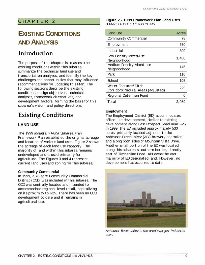
Existing Conditions LAND USE The 1999 Mountain Vista Subarea Plan Framework Plan established the original acreage and location of various land uses. Figure 2 shows the acreage of each land use category. The majority of land within this subarea remains undeveloped and is used primarily for agriculture. The Figures 3 and 4 represent current land uses and zoning for this subarea. Community Commercial In 1999, a 78-acre Community Commercial District (CCD) was included in this subarea. The CCD was centrally located and intended to accommodate regional-level retail, capitalizing on its proximity to I-25. There has been no CCD development to date and it remains in agricultural use.
Figure 2 - 1999 Framework Plan Land Uses SOURCE: CITY OF FORT COLLINS GIS
Land Use Acres Community Commercial 78
Employment 530
Industrial 309 Low Density Mixed-use Neighborhood 1,480
Medium Density Mixed-use Neighborhood 145
Park 110
School 108 Water Features/Ditch Corridors/Natural Areas (adjusted) 229
Regional Detention Pond 0
Total 2,989 Employment The Employment District (ED) accommodates office-like development, similar to existing development along East Prospect Road near I-25. In 1999, the ED included approximately 530 acres, primarily located adjacent to the Anheuser-Busch InBev (ABI) brewery operation and along both sides of Mountain Vista Drive. Another small portion of the ED was located along this subarea’s southern border, directly east of Timberline Road. ABI owns the vast majority of ED designated land. However, no development has occurred to date.
Anheuser-Busch InBev is the area’s largest industrial user.
MOUNTAIN VISTA SUBAREA PLAN
10 CHAPTER 2 – EXISTING CONDITIONS & ANALYSIS
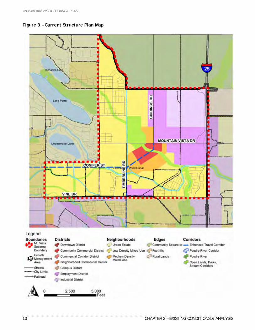
Figure 3 – Current Structure Plan Map
MOUNTAIN VISTA SUBAREA PLAN
CHAPTER 2 – EXISTING CONDITIONS and ANALYSIS 11
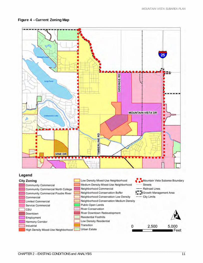
Figure 4 – Current Zoning Map
MOUNTAIN VISTA SUBAREA PLAN
12 CHAPTER 2 – EXISTING CONDITIONS and ANALYSIS
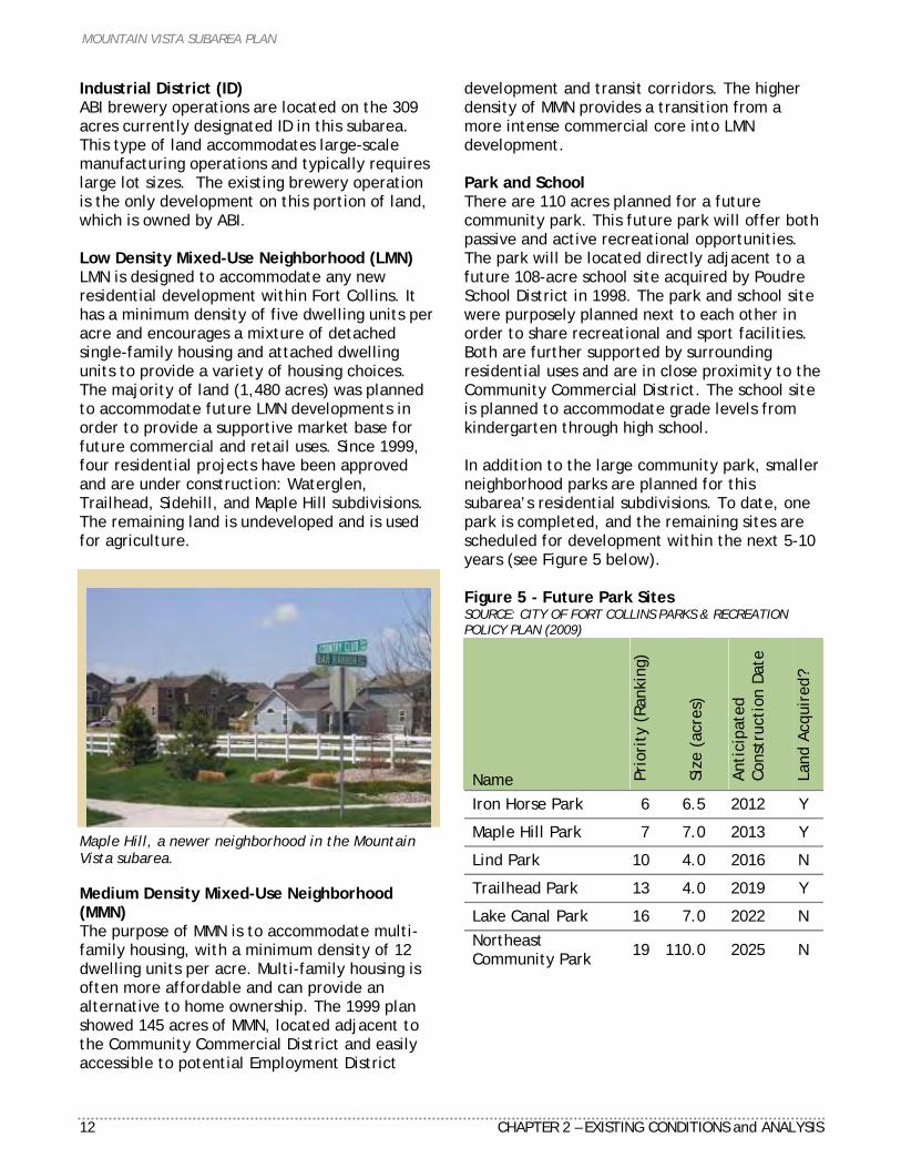
Industrial District (ID) ABI brewery operations are located on the 309 acres currently designated ID in this subarea. This type of land accommodates large-scale manufacturing operations and typically requires large lot sizes. The existing brewery operation is the only development on this portion of land, which is owned by ABI. Low Density Mixed-Use Neighborhood (LMN) LMN is designed to accommodate any new residential development within Fort Collins. It has a minimum density of five dwelling units per acre and encourages a mixture of detached single-family housing and attached dwelling units to provide a variety of housing choices. The majority of land (1,480 acres) was planned to accommodate future LMN developments in order to provide a supportive market base for future commercial and retail uses. Since 1999, four residential projects have been approved and are under construction: Waterglen, Trailhead, Sidehill, and Maple Hill subdivisions. The remaining land is undeveloped and is used for agriculture.
Maple Hill, a newer neighborhood in the Mountain Vista subarea. Medium Density Mixed-Use Neighborhood (MMN) The purpose of MMN is to accommodate multi-family housing, with a minimum density of 12 dwelling units per acre. Multi-family housing is often more affordable and can provide an alternative to home ownership. The 1999 plan showed 145 acres of MMN, located adjacent to the Community Commercial District and easily accessible to potential Employment District
development and transit corridors. The higher density of MMN provides a transition from a more intense commercial core into LMN development. Park and School There are 110 acres planned for a future community park. This future park will offer both passive and active recreational opportunities. The park will be located directly adjacent to a future 108-acre school site acquired by Poudre School District in 1998. The park and school site were purposely planned next to each other in order to share recreational and sport facilities. Both are further supported by surrounding residential uses and are in close proximity to the Community Commercial District. The school site is planned to accommodate grade levels from kindergarten through high school. In addition to the large community park, smaller neighborhood parks are planned for this subarea’s residential subdivisions. To date, one park is completed, and the remaining sites are scheduled for development within the next 5-10 years (see Figure 5 below). Figure 5 - Future Park Sites SOURCE: CITY OF FORT COLLINS PARKS & RECREATION POLICY PLAN (2009)
Name Prio
rity
(Ra
nkin
g)
Size
(ac
res)
Anti
cipa
ted
Cons
truc
tion
Dat
e
Land
Acq
uire
d?
Iron Horse Park 6 6.5 2012 Y
Maple Hill Park 7 7.0 2013 Y
Lind Park 10 4.0 2016 N
Trailhead Park 13 4.0 2019 Y
Lake Canal Park 16 7.0 2022 N Northeast Community Park 19 110.0 2025 N
MOUNTAIN VISTA SUBAREA PLAN
CHAPTER 2 – EXISTING CONDITIONS and ANALYSIS 13
Figure 6 - Water Features/Ditch Corridors/Natural Areas Map
MOUNTAIN VISTA SUBAREA PLAN
14 CHAPTER 2 – EXISTING CONDITIONS and ANALYSIS
Water Features/Ditch Corridors/Natural Areas Shown in Figure 2 on page 9, the 1999 mapping calculations did not include a category for water features, ditch corridors and natural areas together. As part of the 2009 update, the City’s Geographic Information Services (GIS) adjusted the 1999 framework plan map to more accurately compare with their new 2009 calculations.
Larimer & Weld Canal.
Upper Cooper Slough wetland. The 1999 plan shows a total of 229 acres of existing water features, ditch corridors and natural areas. This includes the designated development buffer areas for each category; see Figure 6 on the previous page. The existing drainage canals and water features include the Larimer and Weld Canal, the Lake Canal, and the No. 8 Ditch Outlet. Two existing natural areas exist in this subarea. The first natural area is within the Waterglenn subdivision northwest
of I-25 and East Vine Drive and is part of the Upper Cooper Slough Drainage Basin. The second natural area is located on private land approximately ½-mile northwest of Vine Drive and Timberline Road. Additional riparian habitat including tree and low groundcover vegetation exist along irrigation ditch and canal facilities. These natural resources provide important wildlife movement corridors and habitat space. TRANSPORTATION The Mountain Vista subarea and northeast Fort Collins is a mixture of properties both inside and outside of city limits. A loosely connected street system was developed to serve existing and new development. In most cases, local streets do not comply with the current Larimer County Urban Area Street Standards. This often means a lack of infrastructure such as sidewalks, bicycle lanes, and curb and gutter infrastructure. Street Network Most of this subarea’s streets were constructed in Larimer County, and came under City jurisdiction as properties were annexed or developed. Most of the arterial streets have a 60-foot right-of-way (ROW), typical of rural county roads. Exceptions include the streets adjacent to the Anheuser-Busch InBev brewery, which have a 100-foot ROW negotiated as part of the company's master development agreement. All of the streets in the Mountain Vista Subarea are paved, with the exception of Richards Lake Road between Giddings Road and the No. 8 Ditch (eastern border of Maple Hill). New collector and local streets have been constructed as development occurred. As shown on the Master Street Plan, this included several of the streets through the Waterglen and Maple Hill subdivisions. These streets are slated for completion or extension to connect to future development. Turnberry Road was relocated to the east, in conjunction with the Maple Hill development, to allow construction of a full street cross-section and safer driveway access for county residents on the west side of the road.
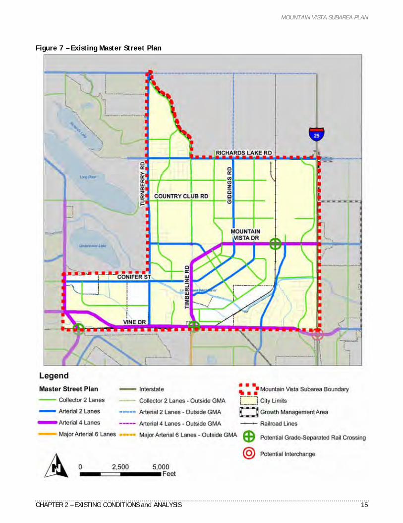
MOUNTAIN VISTA SUBAREA PLAN
CHAPTER 2 – EXISTING CONDITIONS and ANALYSIS 15
Figure 7 – Existing Master Street Plan
MOUNTAIN VISTA SUBAREA PLAN
16 CHAPTER 2 – EXISTING CONDITIONS and ANALYSIS
A number of street bridges were constructed over canals and other waterways. In recent years, a new bridge was built along Timberline at the Larimer and Weld Canal. The new bridge will accommodate a widened Timberline Road and meet City standards. Interstate 25 Access This subarea is served by the northernmost Fort Collins interchange at Mountain Vista Drive. A diamond interchange, consistent with current Colorado Department of Transportation (CDOT) standards, was improved in the early 1980’s. No further improvements to this interchange are anticipated in the near future. General safety improvements to I-25 are planned as part of the North I-25 Environmental Impact Statement currently underway by CDOT. The Master Street Plan currently recommends a future interchange at Vine Drive and I-25. This interchange was not included in the North I-25 Environmental Impact Statement. If future improvements are warranted and desired, a separate planning process is required prior to construction. This process would include the City of Fort Collins, the Town of Timnath, and CDOT. Bikeway System The bikeway system is largely made up of on-street bicycle lanes. Both the 2008 Bicycle Plan and the Parks and Recreation Policy Plan outline an extensive network of on- and off-street bicycle lanes and trails. This more robust system will occur along with development and available funding as new streets and trails are constructed. In recent years, the City has constructed improvements in advance of the off-street trails including a trail underpass at Richards Lake Road east of Turnberry Road. Transit Service Transfort Route 8 currently serves the western edge of this subarea. The bus route runs through northeast Fort Collins via Vine Drive, Lemay Avenue, Conifer Street and College Avenue. This provides connections to the River District, the Larimer County Department of Human Services, the North College Corridor, and Old Town Fort Collins. Transfort recently amended the route to include service to the new Northside Aztlan Community Center.
The 1999 Plan and the 2004 Transportation Master Plan identified Conifer Street as part of the Mountain Vista/North College Enhanced Travel Corridor. This corridor would provide safe, convenient, and direct travel with an emphasis on high-frequency transit service, and enhanced bicycle and pedestrian facilities.
Framework Plan Objectives The project team identified key design objectives to provide criteria and basis for updating the 1999 Plan. Objectives for land use, transportation and open lands include the following: LAND USE Create an Anheuser-Busch InBev Anchored Major Employment Center The northeast part of this subarea is anchored by the existing Anheuser-Busch InBev brewery, and will serve as a future major industrial and employment center for Fort Collins. Establish Buffer and Transition Between Industrial and Residential Areas An appropriate separation and buffer will be established between the industrial ABI brewery operation and nearby existing and future residential neighborhoods, extending about one mile. The Employment District will be expanded to provide this transition. Promote the Marketability of the Employment Center This northeast employment district is uniquely marketable with available large parcel sizes, direct access to an improved I-25 interchange, and railroad access. Centrally Locate the Community Commercial District A centrally-located Community Commercial District (CCD) will serve this subarea’s existing and future neighborhoods, schools, and business centers and not compete with regional retail uses along I-25.
MOUNTAIN VISTA SUBAREA PLAN
CHAPTER 2 – EXISTING CONDITIONS and ANALYSIS 17
Use a “Town Center” Design for the Community Commercial District The CCD will reflect the vision of City Plan. This will include a “town center” block pattern, active street frontages, a mix of supporting land uses such as ground floor retail and office, and above ground residential uses, branch civic services and public gathering places. The CCD will emphasize and support pedestrian activity. Establish Connections City-wide via Enhanced Travel Corridors This subarea will be linked to the rest of Fort Collins by connecting Enhanced Travel Corridors (ETC) along Timberline Road and the extension of realigned Vine Drive, providing high frequency transit connections between destinations. Plan for Community Facilities This subarea will plan for key community facilities such as neighborhood and community parks, schools, public plazas, a transit station, police substation, and branch library. Locate Medium Density Mixed-Use Neighborhoods Near the Community Commercial District Medium Density Mixed-Use Neighborhoods will be adjacent to the CCD and along the ETC routes to provide higher density multi-family housing within walking distance to transit and primary shopping destinations. Share Facilities Between the Community Park and Poudre School District Site The planned 110-acre community park will be located adjacent to the Poudre School District site in order to maximize opportunities to share facilities. Balance Residential & Commercial Uses Maintain an appropriate balance of residential and non-residential uses to support the jobs/housing balance city-wide. TRANSPORTATION Provide Transportation Choices The transportation network will provide a balance of travel modes including vehicular, transit, pedestrian, and bicycle choices.
Refine the Street Network The 1999 Framework Plan street network will be reevaluated during this update to reflect new traffic modeling analysis and adjustments to the existing and future land uses in this subarea Connect the Key Destinations The transportation network will accommodate the long-term traffic forecasting demand. It will provide connectivity and access to key subarea destinations, other destinations in Fort Collins, and neighboring communities. Minimize the Impacts of the Extension of Realigned Vine Drive Impacts to natural areas, neighborhoods, homes, and the historic Plummer School will be minimized or removed with the consideration of the extension of realigned Vine Drive. Designate Realigned Vine Drive as the Enhanced Travel Corridor The current location for the ETC on Conifer Street is proposed to be relocated to the future extension of realigned Vine Drive between College Avenue and Timberline Road. This will allow a more direct connection to and from this subarea and serve the largest concentration of land uses. OPEN LANDS Adhere to the Parks and Recreation Policy Plan This subarea’s planned community and neighborhood parks and trail network will be consistent with the adopted Parks and Recreation Policy Plan. Preserve and Protect the Natural Environment Existing natural areas and wetlands will be preserved and protected in coordination with existing and future development. Improvements to the No. 8 Ditch The No. 8 Ditch owned by the Windsor Reservoir Company, provides both irrigation water rights delivery and storm runoff conveyance. Improvements and enhancements to the No. 8 Ditch should be implemented including ditch slope grading, clean-up, landscape improvements, and trail alignment. Any improvements must be coordinated with the
MOUNTAIN VISTA SUBAREA PLAN
18 CHAPTER 2 – EXISTING CONDITIONS and ANALYSIS
ditch company, Poudre School District and the City of Fort Collins. Take Advantage of Recreational Opportunities Planned regional detention basins should provide a combination of stormwater functions, and recreation access to take advantage of open land opportunities.
Analysis Technical analyses, based upon existing conditions and objectives, were completed by the project team and include: Travel demand modeling. Air quality. Noise. Land use market. Framework plan alternative analyses.
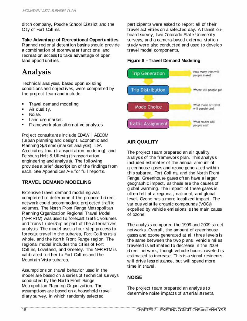
Project consultants include EDAW | AECOM (urban planning and design), Economic and Planning Systems (market analysis), LSA Associates, Inc. (transportation modeling), and Felsburg Holt & Ullevig (transportation engineering and analysis). The following provides a brief description of the findings from each. See Appendices A-E for full reports. TRAVEL DEMAND MODELING Extensive travel demand modeling was completed to determine if the proposed street network could accommodate projected traffic volumes. The North Front Range Metropolitan Planning Organization Regional Travel Model (NFR RTM) was used to forecast traffic volumes and transit ridership as part of the alternatives analysis. The model uses a four-step process to forecast travel in the subarea, Fort Collins as a whole, and the North Front Range region. The regional model includes the cities of Fort Collins, Loveland, and Greeley. The NFR RTM is calibrated further to Fort Collins and the Mountain Vista subarea. Assumptions on travel behavior used in the model are based on a series of technical surveys conducted by the North Front Range Metropolitan Planning Organization. The assumptions are based on a household travel diary survey, in which randomly selected
participants were asked to report all of their travel activities on a selected day. A transit on-board survey, two Colorado State University surveys, and a camera-based external station study were also conducted and used to develop travel model components. Figure 8 – Travel Demand Modeling
AIR QUALITY The project team prepared an air quality analysis of the framework plan. This analysis included estimates of the annual amount of greenhouse gases and ozone generated within this subarea, Fort Collins, and the North Front Range. Greenhouse gases often have a larger geographic impact, as these are the causes of global warming. The impact of these gases is often felt at a regional, national, and global level. Ozone has a more localized impact. The various volatile organic compounds (VOCs) expelled by vehicle emissions is the main cause of ozone. The analysis compared the 1999 and 2009 street networks. Overall, the amount of greenhouse gases and ozone generated at all three levels is the same between the two plans. Vehicle miles traveled is estimated to decrease in the 2009 street network, though vehicle hours traveled is estimated to increase. This is a signal residents will drive less distance, but will spend more time in travel. NOISE The project team prepared an analysis to determine noise impacts of arterial streets,
MOUNTAIN VISTA SUBAREA PLAN
CHAPTER 2 – EXISTING CONDITIONS and ANALYSIS 19
particularly the extension of realigned Vine Drive. Two different standards were used in this analysis: a 55db US Environmental Protection Agency standard and a 66db Colorado Department of Transportation standard. Both are intended to determine the area along a street where noise levels would exceed the two standards. It should be noted the analysis is based on a “flat earth” assumption (i.e. no topography, no development, no landscaping, etc). Fencing, development patterns, and landscaping would all reduce the noise impact of an adjacent street. LAND USE DEMAND MARKET ANALYSIS The updated 2009 Land Use Demand Market Analysis Report developed by Economic and Planning Systems, Inc. evaluates the market demand for the land uses as shown in the adopted 1999 Framework Plan. The report uses the outcome of the land demand forecasts to provide a basis to guide the development of the proposed 2009 Framework Plan. The following findings represent a summary of the more detailed report located in Appendix B. A 25- to 35-acre Community Commercial
District should form the nucleus of this subarea. A grocery store anchor will likely be the most successful at integrating a mixed-use town center.
A separate 4 to 6-acre neighborhood center including non-residential uses is supportable in the early years of development within Low Density Mixed-Use Neighborhood zoning. A potential location for this additional retail development is near the intersection of Vine and Lemay, adjacent to the realigned Vine Drive enhanced travel corridor.
The Framework Plan includes an additional 131 acres of Employment land. This increase will result in a 13% increase in the existing land capacity of 1,012 acres.
The land demand analysis identified a small shortfall in Industrial-zoned land capacity. The Mountain Vista Subarea provides an opportunity to correct this shortfall and provide additional capacity for industrial development beyond the 2030 time horizon.
Due to the limitations imposed by the Growth Management Area, an oversupply in either Employment- or Industrial-zoned land
is beneficial to provide flexibility to respond to changing market conditions.
The changes to the supply of Employment- and Industrial-zoned land included in the preferred Framework Plan will have only a marginal impact (within the margin of error) on the jobs/housing balance ratio and should therefore not prevent the proposed zone changes from occurring.
Medium density multi-family development in Fort Collins (outside the downtown market area) is currently primarily driven by affordability. The demand in the Mountain Vista Subarea is likely to follow this pattern of affordability mirroring comparable development. Based on this conclusion, the subarea can support between 130 and 150 acres of medium density multifamily housing.
The proposed town center forming the nucleus of the updated Mountain Vista Subarea Plan should include between 30 to 50 acres of medium density multifamily housing. The remaining medium density zoning, approximately 80 to 100 acres, should be located along the proposed enhanced travel corridor and at major intersections in the subarea.
The preferred Framework Plan includes approximately 12% less land zoned for Low Density Mixed-Use Neighborhood. The loss of this residential designation has only a marginal impact on the jobs/housing balance.
The Framework Plan map is closely aligned with residential and commercial market demand.
FRAMEWORK PLAN ALTERNATIVES Staff prepared six Framework Plan alternatives and presented them to the public in order to test various land use and transportation configurations. Three of the maps were unveiled at the open house in December; the other three at the second open house in February. Overall, the acreage of each land use did not change significantly from one alternative to another. However, the center of the subarea tested various locations for the CCD and surrounding residential land uses. The transportation network varied with regard to the extension of realigned Vine Drive and how it connects into
MOUNTAIN VISTA SUBAREA PLAN
20 CHAPTER 2 – EXISTING CONDITIONS and ANALYSIS
Timberline Road and Mountain Vista Drive, the extension of Turnberry Road and Conifer Street, and the overall street network. See Appendix B to view the six Framework Plan alternatives.
Development Factors Based upon the review of existing conditions, technical analyses and extensive input from stakeholders and area residents, the following summary describes various factors affecting this subarea’s growth and development. They are also illustrated graphically in Figure 9. EXISTING OWNERSHIP AND LAND USE The majority of this subarea remains undeveloped, which presents an opportunity to apply the most current City Plan concepts. Overall, this subarea is under the possession of approximately 30 large-parcel landowners, with Anheuser-Busch InBev being the largest. Cooperation among the landowners concerning potential development, location of streets, and an overall vision for the area will influence the success and timing of this subarea’s development. ADJACENT RESIDENTIAL NEIGHBORHOODS Existing subdivisions are located to the west of this subarea such as Country Club, Adrial Hills, Lindenwood, and long-established single-family neighborhoods such as Alta Vista and Andersonville. This subarea’s urban residential densities, commercial, and employment uses may impact these neighborhoods. Appropriate and innovative design of new development will help provide a transition adjacent to existing neighborhoods. Furthermore, the proposed transportation network will provide additional connections for travel between this subarea and other destinations throughout Fort Collins. EXISTING RAILROAD SWITCHING YARD The Burlington Northern Santa Fe Railway (BNSF) switching yard is located along Vine Drive between Lemay Avenue and Timberline Drive, and is operated by both the BNSF and Great
West railroad companies. The proximity of this switching yard to at-grade railroad crossings can impact efficient traffic flow and create safety hazards and noise issues. The proposed grade- separated rail crossings will provide more efficient and safer traffic movement at arterial street intersections in the area. STORMWATER DRAINAGE The majority of the subarea falls within the Upper Cooper Slough Drainage Basin, which naturally flows from the north to the southeast. The main factors that may influence development include foodplain impacts and storm drainage flows. The update to the Upper Cooper Slough Drainage Master Plan include recommendations to mitigate these two main factors by identifying implementation improvements to existing ditch facilities, slope grading and constructing new regional detention ponds within the subarea. The Dry Creek drainage basin extends through the southwest portion of the plan area near Lemay Avenue and Vine Drive. The historic Dry Creek channel daylights east of the Lake Canal and runs through the Alta Vista neighborhood, across Lemay Avenue and Vine Drive, and then southeast through the Airpark area. A floodplain exists along this historic channel, affecting new residential development areas, as well as existing development in the Alta Vista area both east and west of Lemay Avenue. The City of Fort Collins has implemented several Dry Creek drainage improvement projects to mitigate the impacts of the Dry Creek floodpain. A key remaining Dry Creek improvement project is the Northeast College Corridor Outfall Project (NECCO). Most of the NECCO project is located near the North College Corridor Plan area. The eastern portion of this project extends through the Mountain Vista Subarea Plan and will provide outfall for the Dry Creek drainage. Dry Creek improvements include constructing a new underground culvert to intercept flows upstream of the historic channel and carry them in a pipe north of the historic Dry Creek channel. Construction will not require disturbance of the historic channel. This pipe network would remove the floodplain from the area.
MOUNTAIN VISTA SUBAREA PLAN
CHAPTER 2 – EXISTING CONDITIONS and ANALYSIS 21
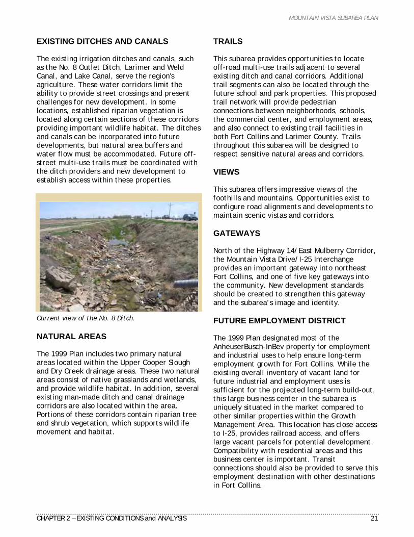
EXISTING DITCHES AND CANALS The existing irrigation ditches and canals, such as the No. 8 Outlet Ditch, Larimer and Weld Canal, and Lake Canal, serve the region's agriculture. These water corridors limit the ability to provide street crossings and present challenges for new development. In some locations, established riparian vegetation is located along certain sections of these corridors providing important wildlife habitat. The ditches and canals can be incorporated into future developments, but natural area buffers and water flow must be accommodated. Future off-street multi-use trails must be coordinated with the ditch providers and new development to establish access within these properties.
Current view of the No. 8 Ditch. NATURAL AREAS The 1999 Plan includes two primary natural areas located within the Upper Cooper Slough and Dry Creek drainage areas. These two natural areas consist of native grasslands and wetlands, and provide wildlife habitat. In addition, several existing man-made ditch and canal drainage corridors are also located within the area. Portions of these corridors contain riparian tree and shrub vegetation, which supports wildlife movement and habitat.
TRAILS This subarea provides opportunities to locate off-road multi-use trails adjacent to several existing ditch and canal corridors. Additional trail segments can also be located through the future school and park properties. This proposed trail network will provide pedestrian connections between neighborhoods, schools, the commercial center, and employment areas, and also connect to existing trail facilities in both Fort Collins and Larimer County. Trails throughout this subarea will be designed to respect sensitive natural areas and corridors. VIEWS This subarea offers impressive views of the foothills and mountains. Opportunities exist to configure road alignments and developments to maintain scenic vistas and corridors. GATEWAYS North of the Highway 14/East Mulberry Corridor, the Mountain Vista Drive/I-25 Interchange provides an important gateway into northeast Fort Collins, and one of five key gateways into the community. New development standards should be created to strengthen this gateway and the subarea’s image and identity. FUTURE EMPLOYMENT DISTRICT The 1999 Plan designated most of the AnheuserBusch-InBev property for employment and industrial uses to help ensure long-term employment growth for Fort Collins. While the existing overall inventory of vacant land for future industrial and employment uses is sufficient for the projected long-term build-out, this large business center in the subarea is uniquely situated in the market compared to other similar properties within the Growth Management Area. This location has close access to I-25, provides railroad access, and offers large vacant parcels for potential development. Compatibility with residential areas and this business center is important. Transit connections should also be provided to serve this employment destination with other destinations in Fort Collins.
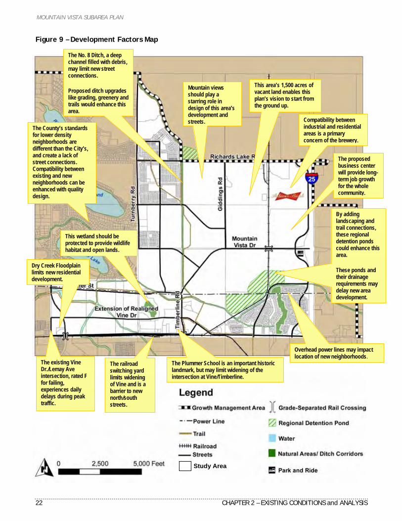
MOUNTAIN VISTA SUBAREA PLAN
22 CHAPTER 2 – EXISTING CONDITIONS and ANALYSIS
Figure 9 – Development Factors Map
The Plummer School is an important historic landmark, but may limit widening of the intersection at Vine/Timberline.
This area’s 1,500 acres of vacant land enables this plan’s vision to start from the ground up.
The railroad switching yard limits widening of Vine and is a barrier to new north/south streets.
Mountain views should play a starring role in design of this area’s development and streets. Compatibility between
industrial and residential areas is a primary concern of the brewery.
The proposed business center will provide long-term job growth for the whole community.
The No. 8 Ditch, a deep channel filled with debris, may limit new street connections. Proposed ditch upgrades like grading, greenery and trails would enhance this area.
Dry Creek Floodplain limits new residential development.
Overhead power lines may impact location of new neighborhoods.
This wetland should be protected to provide wildlife habitat and open lands.
The County’s standards for lower density neighborhoods are different than the City’s, and create a lack of street connections. Compatibility between existing and new neighborhoods can be enhanced with quality design.
By adding landscaping and trail connections, these regional detention ponds could enhance this area. These ponds and their drainage requirements may delay new area development.
Study Area
The existing Vine Dr./Lemay Ave intersection, rated F for failing, experiences daily delays during peak traffic.
MOUNTAIN VISTA SUBAREA PLAN
CHAPTER 2 – EXISTING CONDITIONS and ANALYSIS 23
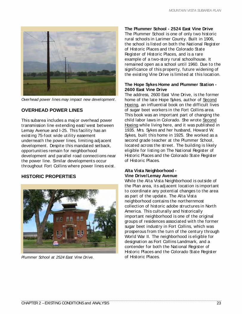
Overhead power lines may impact new development. OVERHEAD POWER LINES This subarea includes a major overhead power transmission line extending east/west between Lemay Avenue and I-25. This facility has an existing 75-foot wide utility easement underneath the power lines, limiting adjacent development. Despite this mandated setback, opportunities remain for neighborhood development and parallel road connections near the power line. Similar developments occur throughout Fort Collins where power lines exist. HISTORIC PROPERTIES
Plummer School at 2524 East Vine Drive.
The Plummer School - 2524 East Vine Drive The Plummer School is one of only two historic rural schools in Larimer County. Built in 1906, the school is listed on both the National Register of Historic Places and the Colorado State Register of Historic Places, and is a rare example of a two-story rural schoolhouse. It remained open as a school until 1960. Due to the significance of this property, future widening of the existing Vine Drive is limited at this location. The Hope Sykes Home and Plummer Station - 2600 East Vine Drive The address, 2600 East Vine Drive, is the former home of the late Hope Sykes, author of Second Hoeing, an influential book on the difficult lives of sugar beet workers in the Fort Collins area. This book was an important part of changing the child labor laws in Colorado. She wrote Second Hoeing while living here, and it was published in 1935. Mrs. Sykes and her husband, Howard W. Sykes, built this home in 1925. She worked as a second grade teacher at the Plummer School, located across the street. The building is likely eligible for listing on The National Register of Historic Places and the Colorado State Register of Historic Places. Alta Vista Neighborhood - Vine Drive/Lemay Avenue While the Alta Vista Neighborhood is outside of the Plan area, its adjacent location is important to coordinate any potential changes to the area as part of the update. The Alta Vista neighborhood contains the northernmost collection of historic adobe structures in North America. This culturally and historically important neighborhood is one of the original groups of residences associated with the former sugar beet industry in Fort Collins, which was prosperous from the turn of the century through World War II. The neighborhood is eligible for designation as Fort Collins Landmark, and a contender for both the National Register of Historic Places and the Colorado State Register of Historic Places.
MOUNTAIN VISTA SUBAREA PLAN
24 CHAPTER 2 – EXISTING CONDITIONS and ANALYSIS
MOUNTAIN VISTA SUBAREA PLAN
CHAPTER 3 - VISION 25
C H A P T E R 3
VISION
Introduction City Plan’s vision focuses on what our community will be like in the future. The City’s vision is to channel growth into positive community development. Therefore, our community will have a compact land use pattern, consisting of a primary, vital downtown and other supporting districts that serve as focal points and centers of activity, and a variety of pleasant residential neighborhoods and places linked by inviting streetscapes, walkways and open lands. The Mountain Vista Subarea Plan’s vision reinforces and demonstrates the intent of City Plan while addressing more area-specific issues associated with the northeast quadrant of Fort Collins. The vision describes this subarea’s general overall development scenario in the future, about twenty years out. This vision reflects a desired outcome, or map, in charting the course to realizing the plan. Building on this vision, the next steps to achieve the Plan include developing more specific principles and policies, which will then form the foundation for implementation.
Plan Vision This subarea will be an integral part of Fort Collins, functioning as an extension of the greater community as new growth takes form. This subarea will be an area of Fort Collins known for its impressive views of the mountains and recognized for its successful and innovative community design. This subarea will be distinct and attractive with a comfortable, town-like atmosphere that residents and businesses identify with and take pride in. Neighborhoods, parks, schools, shopping district and business centers within this subarea will be connected and served by a variety of travel choices including vehicle, transit, bicycle, and pedestrian modes. The additional statements that follow are facets or subsets of the overall vision.
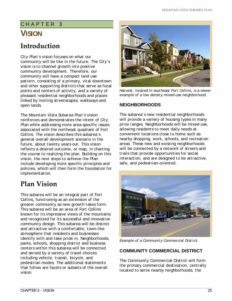
Harvest, located in southeast Fort Collins, is a newer example of a low density mixed-use neighborhood. NEIGHBORHOODS The subarea’s new residential neighborhoods will provide a variety of housing types in many price ranges. Neighborhoods will be mixed-use, allowing residents to meet daily needs at convenient locations close to home such as nearby shopping, work, schools, and recreation areas. These new and existing neighborhoods will be connected by a network of streets and trails that provide opportunities for social interaction, and are designed to be attractive, safe, and pedestrian-oriented.
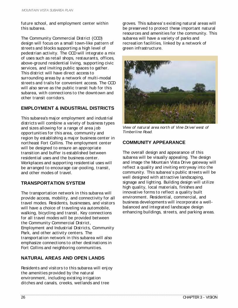
Example of a Community Commercial District. COMMUNITY COMMERCIAL DISTRICT The Community Commercial District will form the primary commercial destination, centrally located to serve nearby neighborhoods, the
MOUNTAIN VISTA SUBAREA PLAN
26 CHAPTER 3 - VISION
future school, and employment center within this subarea. The Community Commercial District (CCD) design will focus on a small town-like pattern of streets and blocks supporting a high level of pedestrian activity. The CCD will integrate a mix of uses such as retail shops, restaurants, offices, above-ground residential living, supporting civic services, and inviting public spaces to gather. This district will have direct access to surrounding areas by a network of multi-modal streets and trails for convenient access. The CCD will also serve as the public transit hub for this subarea, with connections to the downtown and other transit corridors. EMPLOYMENT & INDUSTRIAL DISTRICTS This subarea's major employment and industrial districts will combine a variety of business types and sizes allowing for a range of area job opportunities for this area, community and region by establishing a major business center in northeast Fort Collins. The employment center will be designed to ensure an appropriate transition and buffer is established between residential uses and the business center. Workplaces and supporting residential uses will be arranged to encourage car-pooling, transit, and other modes of travel. TRANSPORTATION SYSTEM The transportation network in this subarea will provide access, mobility, and connectivity for all travel modes. Residents, businesses, and visitors will have a choice of traveling via automobile, walking, bicycling and transit. Key connections for all travel modes will be provided between the Community Commercial District, Employment and Industrial Districts, Community Park, and other activity centers. The transportation network in this subarea will also emphasize connections to other destinations in Fort Collins and neighboring communities. NATURAL AREAS AND OPEN LANDS Residents and visitors to this subarea will enjoy the amenities provided by the natural environment, including existing irrigation ditches and canals, creeks, wetlands and tree
groves. This subarea’s existing natural areas will be preserved to protect these important natural resources and amenities for the community. This subarea will have a variety of parks and recreation facilities, linked by a network of green infrastructure.
View of natural area north of Vine Drive/west of Timberline Road. COMMUNITY APPEARANCE The overall design and appearance of this subarea will be visually appealing. The design and image the Mountain Vista Drive gateway will reflect a quality and inviting entryway into the community. This subarea’s public streets will be well designed with attractive landscaping, signage and lighting. Building design will utilize high quality, local materials, finishes and innovative forms to reflect a quality built environment. Residential, commercial, and business developments will incorporate a well-balanced and integrated landscape design enhancing buildings, streets, and parking areas.
MOUNTAIN VISTA SUBAREA PLAN
CHAPTER 4 – FRAMEWORK PLAN 27
C H A P T E R 4
FRAMEWORK PLAN
Introduction City Plan addresses community-wide issues and a long-term vision, which emphasizes compact urban form, with “Activity Centers” in transit-served areas, and an interconnected system of open lands. The Mountain Vista Framework Plan supports these community-wide concepts at a more detailed neighborhood level for this specific part of the city. The Framework Plan will be incorporated directly into the overall City Structure Plan, which is part of City Plan. The centerpiece of the Mountain Vista Subarea Plan is a Framework Plan. This “framework” represents an integrated pattern of existing and future land use, transportation system, and network of open lands, all combined into a composite map establishing a guide for growth in this subarea. Key building blocks include existing and new residential neighborhoods, schools, parks, commercial centers, business center, and network of open lands. These destinations will be linked by a system of transportation corridors serving vehicular, transit, bicycle and pedestrian travel that provide a high level of connectivity, internally and to other destinations throughout the community. This chapter is organized into three main sections including land use, transportation and open lands. The majority of this chapter relates to a comparison of the 1999 and 2009 Framework Plans.
Land Use KEY ISSUES The following land use issues were specifically addressed in the framework plan alternatives analysis as part of the planning process. The project team reviewed each of these issues both separately and as they pertain to the overall Mountain Vista Subarea Plan and Fort Collins at large.
Buffer and Transition Between Industrial and Residential Land Uses. The 1999 Framework Plan established an approximate ½-mile separation between the Anheuser-Bush InBev brewery and residential uses to the west. Representatives of ABI requested increasing this separation between uses by expanding the Employment District. This increase will remove previously designated residential uses from ABI property and extend the buffer to approximately one mile. The objective of this recommendation is to reduce incompatible uses, strengthen the buffer and transition between uses, and provide a larger business center in this subarea. Future Community Park The project team assessed a variety of options for the location and size of the future Community Park. A shared objective of both the City's Parks Planning Department and Poudre School District is to co-locate the school site with the future park to maximize facility-sharing opportunities. Discussion with area land owners adjacent to the school site has led to a preferred location and size similar to the 1999 Plan. The current alignment of Mountain Vista Drive would be impacted by the location of a portion of the park south of this street. Size and Location of Community Commercial District The 1999 Plan included an 80-acre Community Commercial District. At that time the land use market analysis recommended support for a combination of neighborhood and regional retail uses. The updated analysis suggests market support for a smaller center focusing more on neighborhood-oriented retail and a mix of other uses. As part of the planning process, the project team assessed different locations for this district.
MOUNTAIN VISTA SUBAREA PLAN
28 CHAPTER 4 – FRAMEWORK PLAN
Figure 10 – 1999 Framework Plan
MOUNTAIN VISTA SUBAREA PLAN
CHAPTER 4 – FRAMEWORK PLAN 29
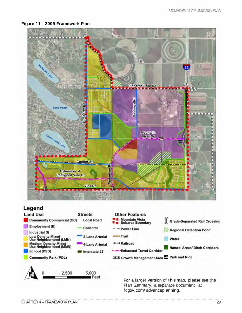
Figure 11 – 2009 Framework Plan
For a larger version of this map, please see the Plan Summary, a separate document, at fcgov.com/advanceplanning.
MOUNTAIN VISTA SUBAREA PLAN
30 CHAPTER 4 – FRAMEWORK PLAN
Can This Subarea Support Additional Commercial Centers? During the alternatives analysis, a few land owners requested designating additional commercial centers adjacent to the proposed realigned Vine Dr, separate from the Community Commercial District location. The new market analysis shows support for an additional small center that would not compete with the larger Community Commercial location. The project team does not believe rezoning is warranted, as this type of small center can be approved through the existing Low and Medium Density Mixed-Use Neighborhoods standards described in the Land Use Code. Amount and Location of Medium Density Mixed-Use Neighborhood (MMN) The 1999 Plan includes 145 acres of MMN located adjacent the Community Commercial District. The project team received a request from a local land owner to reduce the amount of MMN, and by other owners to increase MMN along the Enhanced Travel Corridor. Updated market analysis suggests these changes can be supported by redistributing and increasing the amount of MMN at key arterial street intersections (104 acres), and reducing the amount of MMN within walking distance to the commercial center to 40 acres. Provide More Options to Allow a Variety of Housing Types in Area Representatives of the Moore family, a prominent land owner in the Mountain Vista subarea, have requested a change within the Low Density Mixed-Use Neighborhood Zoning for their property. Justification for this change is to allow more choices for single-family housing types and lot sizes than what current standards allow for. The project team believes the objectives of this request can be accomplished utilizing current standards. Maintain Jobs/Housing Balance City-Wide The 1999 Framework Plan recommendations resulted in a city-wide jobs/housing balance of 1.5 jobs per housing unit. The 2009 Framework Plan results in an increase to this ratio of 1.56. This is still within the desired threshold identified in the City Plan Monitoring Report.
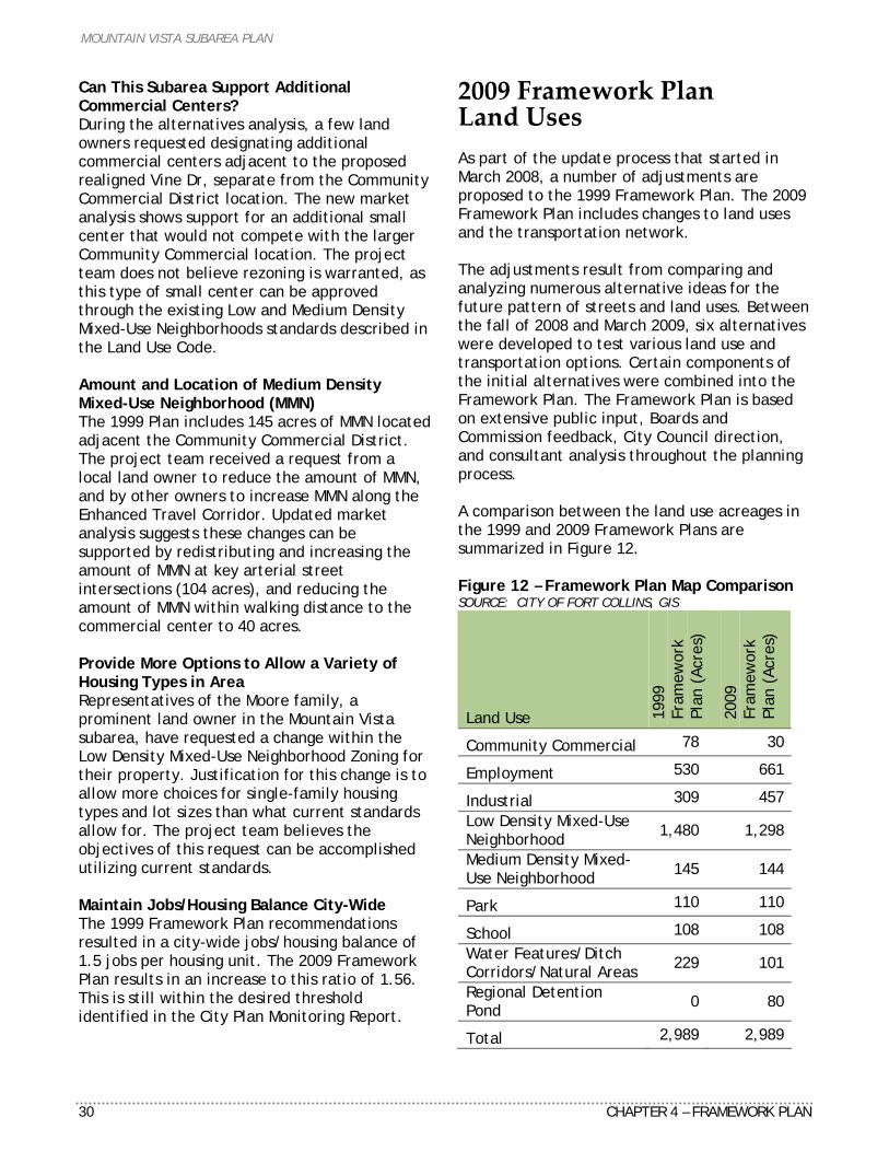
2009 Framework Plan Land Uses As part of the update process that started in March 2008, a number of adjustments are proposed to the 1999 Framework Plan. The 2009 Framework Plan includes changes to land uses and the transportation network. The adjustments result from comparing and analyzing numerous alternative ideas for the future pattern of streets and land uses. Between the fall of 2008 and March 2009, six alternatives were developed to test various land use and transportation options. Certain components of the initial alternatives were combined into the Framework Plan. The Framework Plan is based on extensive public input, Boards and Commission feedback, City Council direction, and consultant analysis throughout the planning process. A comparison between the land use acreages in the 1999 and 2009 Framework Plans are summarized in Figure 12. Figure 12 – Framework Plan Map Comparison SOURCE: CITY OF FORT COLLINS, GIS
Land Use 1999
Fr
amew
ork
Plan
(Ac
res)
2009
Fr
amew
ork
Plan
(Ac
res)
Community Commercial 78 30
Employment 530 661
Industrial 309 457 Low Density Mixed-Use Neighborhood 1,480 1,298
Medium Density Mixed-Use Neighborhood 145 144
Park 110 110
School 108 108 Water Features/Ditch Corridors/Natural Areas 229 101
Regional Detention Pond 0 80
Total 2,989 2,989
MOUNTAIN VISTA SUBAREA PLAN
CHAPTER 4 – FRAMEWORK PLAN 31
In the 1999 Framework Plan, mapping calculations did not include a category for water features, ditch corridors and natural areas together. As part of the 2009 Framework Plan, new mapping calculations have adjusted the 1999 Framework Plan to provide an accurate comparison. As shown in Figure 12, the acreage for this category shows a decrease of 128 acres in the proposed 2009 Framework Plan, from an initial total of 229 acres. No natural areas or other natural resource lands were removed; the mapping boundaries for each type were first recalculated to more accurately compare both Framework Plans. As a result, the 2009 Framework Plan shows 101 acres of water features (streams and canals), irrigation ditch corridors and natural areas (wetlands). MIXED-USE NEIGHBORHOODS Low Density Mixed-Use Neighborhood Low Density Mixed-Use Neighborhood (LMN) represents the largest land use in the Framework Plan (1,298 acres). These neighborhoods will provide for the majority of future residential growth in northeast Fort Collins. The character of these neighborhoods reflects a variety of housing types, predominantly single-family, with supporting parks, schools, trails, and open lands with a minimum average density of five dwelling units per acre. In addition, these future neighborhoods will provide a transition from existing Larimer County development to the west, and higher density neighborhoods, commercial, employment, and industrial uses further to the east.
Examples of LMN (top) and MMN neighborhoods (bottom).
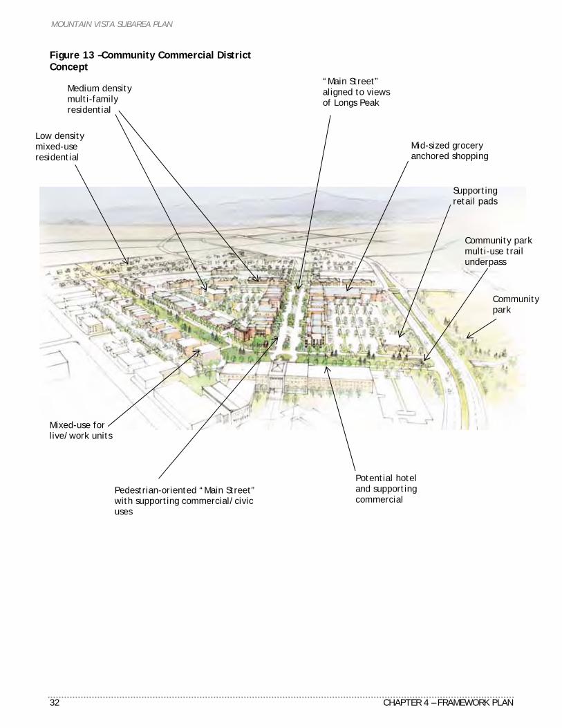
MOUNTAIN VISTA SUBAREA PLAN
32 CHAPTER 4 – FRAMEWORK PLAN
Figure 13 –Community Commercial District Concept
Medium density multi-family residential
“Main Street” aligned to views of Longs Peak
Potential hotel and supporting commercial
Community park multi-use trail underpass
Mid-sized grocery anchored shopping
Mixed-use for live/work units
Community park
Supporting retail pads
Pedestrian-oriented “Main Street” with supporting commercial/civic uses
Low density mixed-use residential
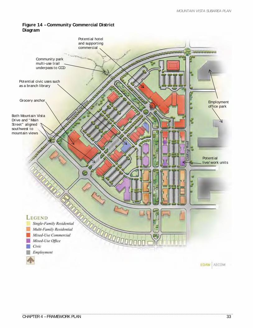
MOUNTAIN VISTA SUBAREA PLAN
CHAPTER 4 – FRAMEWORK PLAN 33
Figure 14 – Community Commercial District Diagram
Potential hotel and supporting commercial
Potential civic uses such as a branch library
Community park multi-use trail underpass to CCD
Grocery anchor
Both Mountain Vista Drive and “Main Street” aligned southwest to mountain views
Potential live/work units
Employment office park
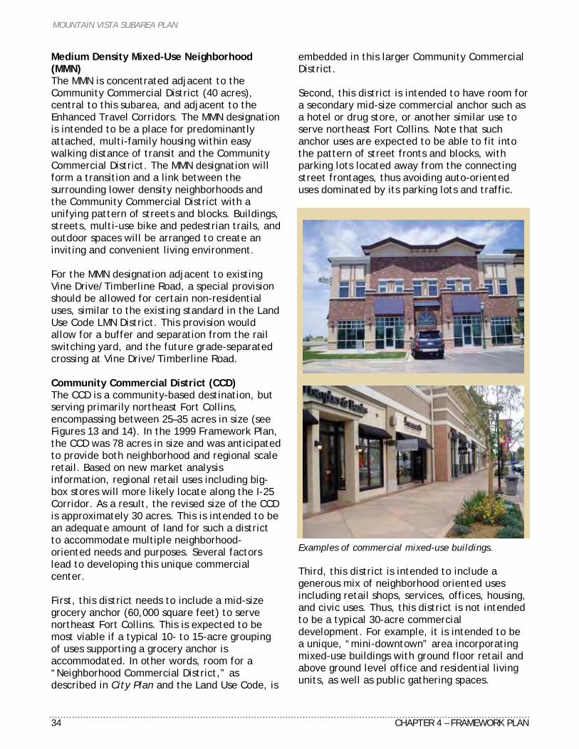
MOUNTAIN VISTA SUBAREA PLAN
34 CHAPTER 4 – FRAMEWORK PLAN
Medium Density Mixed-Use Neighborhood (MMN) The MMN is concentrated adjacent to the Community Commercial District (40 acres), central to this subarea, and adjacent to the Enhanced Travel Corridors. The MMN designation is intended to be a place for predominantly attached, multi-family housing within easy walking distance of transit and the Community Commercial District. The MMN designation will form a transition and a link between the surrounding lower density neighborhoods and the Community Commercial District with a unifying pattern of streets and blocks. Buildings, streets, multi-use bike and pedestrian trails, and outdoor spaces will be arranged to create an inviting and convenient living environment. For the MMN designation adjacent to existing Vine Drive/Timberline Road, a special provision should be allowed for certain non-residential uses, similar to the existing standard in the Land Use Code LMN District. This provision would allow for a buffer and separation from the rail switching yard, and the future grade-separated crossing at Vine Drive/Timberline Road. Community Commercial District (CCD) The CCD is a community-based destination, but serving primarily northeast Fort Collins, encompassing between 25–35 acres in size (see Figures 13 and 14). In the 1999 Framework Plan, the CCD was 78 acres in size and was anticipated to provide both neighborhood and regional scale retail. Based on new market analysis information, regional retail uses including big-box stores will more likely locate along the I-25 Corridor. As a result, the revised size of the CCD is approximately 30 acres. This is intended to be an adequate amount of land for such a district to accommodate multiple neighborhood-oriented needs and purposes. Several factors lead to developing this unique commercial center. First, this district needs to include a mid-size grocery anchor (60,000 square feet) to serve northeast Fort Collins. This is expected to be most viable if a typical 10- to 15-acre grouping of uses supporting a grocery anchor is accommodated. In other words, room for a “Neighborhood Commercial District,” as described in City Plan and the Land Use Code, is
embedded in this larger Community Commercial District. Second, this district is intended to have room for a secondary mid-size commercial anchor such as a hotel or drug store, or another similar use to serve northeast Fort Collins. Note that such anchor uses are expected to be able to fit into the pattern of street fronts and blocks, with parking lots located away from the connecting street frontages, thus avoiding auto-oriented uses dominated by its parking lots and traffic.
Examples of commercial mixed-use buildings. Third, this district is intended to include a generous mix of neighborhood oriented uses including retail shops, services, offices, housing, and civic uses. Thus, this district is not intended to be a typical 30-acre commercial development. For example, it is intended to be a unique, “mini-downtown” area incorporating mixed-use buildings with ground floor retail and above ground level office and residential living units, as well as public gathering spaces.
MOUNTAIN VISTA SUBAREA PLAN
CHAPTER 4 – FRAMEWORK PLAN 35
Fourth, the district will have sections of local streets within the block pattern to reflect a “main street” character with buildings facing the street, on-street parking and wide sidewalks for maximizing pedestrian activity and circulation. This CCD will have a transit hub linked to downtown by a high frequency transit corridor along a new arterial street (the extension of realigned Vine Drive), and along Timberline Road connecting to Harmony Road to the south. The CCD overall street pattern is aligned to take advantage of long-distance views of the mountains. Industrial/Employment Districts The existing Anheuser-Busch InBev brewery establishes the core of future industrial use in the northeast. With future expansion of the brewery and new industry locating adjacent to the brewery, this Industrial District is easily accessed from the interstate, Mountain Vista Drive and the BNSF Railway’s mainline and spur tracks. The Framework Plan shows about 457 acres of Industrial, an increase of 148 acres compared to the 1999 Plan. The location of the Industrial District is separated from the Mountain Vista Drive frontage to buffer this more intense manufacturing use from the light manufacturing and office uses within the Employment areas. In doing so, the Mountain Vista Drive gateway corridor overall appearance is enhanced by incorporating higher quality development typical of Employment uses. The future Employment District is primarily located within the Giddings Road and Mountain Vista Drive corridors, with direct access to Mountain Vista Drive and I-25. This updated plan includes 661 acres of Employment, reflecting an increase of 131 acres from the 1999 plan. The Employment lands will provide both a buffer and transition between the more intense ABI industrial operations and the existing and new residential neighborhoods to the west. Combined, both the Employment and Industrial Districts will provide 1,118 acres of future development, establishing a large future business center for northeast Fort Collins. Demand for this type of growth is not expected in the short term; full build-out of these uses is anticipated near the year 2030.
Future Poudre School District (PSD) Schools In 1998, the Poudre School District acquired approximately 108 acres of land located northeast of Mountain Vista Drive and Timberline Road. The future programming needs for PSD for this property are projected to include a K–12 campus, combining elementary, junior high, and high school facilities. PSD is very supportive of the City collaborating to locate the future community park adjacent to the school, thus maximizing opportunities to share facilities such as access, parking, athletic fields and some utilities. Mountain Vista Drive Gateway The Mountain Vista Drive/I-25 Interchange is an important entryway for northeast Fort Collins. Currently, this corridor is a 2-lane street. Future traffic forecasting indicates this street will need to be expanded to a 4-lane arterial street. A few strategies have been implemented over the past ten years to support this gateway area. First, implementation actions after the adoption of the 1999 plan included adding new standards in the Land Use Code establishing setbacks for residential uses of 1,320 feet, and setbacks for secondary uses of 1,445 feet from the centerline of I-25. These standards allow for a focus of primary uses adjacent to the interchange areas versus allowing for incompatible and auto-oriented uses in these locations. Second, in both the 1999 Plan and in this Plan, Employment land use is located on both sides of Mountain Vista Drive west of I-25. This is similar to the Employment lands along Harmony corridor and East Prospect. This land use is preferred for establishing a foundation for more attractive, quality development at primary entryways. Future action strategies may include establishing new standards for setbacks outside of the arterial street right-of-way, building architecture design, streetscape, and entry features. Jobs to Housing Balance As part of the Plan update, the Framework Plan map has incorporated certain adjustments to the land use designations from the 1999 map, all with an objective of maintaining an appropriate city-wide balance of jobs/housing units. In
MOUNTAIN VISTA SUBAREA PLAN
36 CHAPTER 4 – FRAMEWORK PLAN
particular, staff continued to assess the potential impacts of the recommended expansion of Industrial and Employment, and resulting reduction of Low Density Mixed-Use Neighborhoods designations on the balance of residential and non-residential uses. As a result of these changes, the targeted city-wide balance is still maintained. The rationale for determining an appropriate balance of jobs to housing is based on direction from City Plan policies: “ECON– 1.4 Jobs/Housing Balance. The City will strive to ensure that a reasonable balance between employment and housing is maintained as well as a balance between basic and non-basic jobs. The primary intent is to create a relative balance between the wages generated by various types of employment and housing prices.” The jobs/housing balance is a tool often used to determine whether a community has an adequate number of jobs available to provide employment for all its residents seeking employment. A ratio of less than 1.0 means residents must commute outside the area for employment while a ratio of greater than 1.0 means workers employed within the area generally reside outside the jurisdictional boundaries and commute inwards. The meaning of the jobs/housing balance can often be overstated. In reality, many of the factors influencing this measure are driven by market forces beyond the control of the local community. These market forces include housing prices, housing preference, competitiveness of local businesses, local and state fiscal policy, and job availability. Instead, the measure is more useful for evaluating the overall character of a community as either a bedroom community or an employment center. Under the 1999 plan, this Plan area, at full build-out, has a projected jobs-housing ratio of 1.5 jobs per housing unit city-wide. In the updated 2009 Framework Plan, the jobs-housing ratio is 1.56. This small increase will have a marginal impact on the forecasted ratio city-wide. A common recognized ratio in the planning profession is 1.5 jobs per housing unit
as a preferred or ideal number. In comparison, the state-wide ratio is 1.7 jobs per housing unit. Boulder is considerably higher with a ratio of 2.1. Comparative numbers from either Greeley or Loveland are not available. Historically from 1997-2007, the Fort Collins ratio has remained relatively constant at around 1.4–1.6. As a result, the projected 1.56 ratio reflects a healthy and desired level. The current ratio is projected to remain at about 1.5 to full build-out of the Growth Management Area based on population and employment estimates. In comparing the land uses between the 1999 Framework Plan map and the proposed 2009 map, about 1,625 acres of residential land and 1,364 acres of non-residential land are shown in the existing 1999 map. The proposed 2009 map shows about 1,442 acres of residential, and 1,467 acres of non-residential, resulting in a closer balance of land uses. Population and Employment Projections The projected population for the Mountain Vista Subarea, based on this update, is 13,347. Both the 1999 plan and City Plan projected 17,161 for this area, at full build-out in approximately 2030. In comparison city-wide, this equates to a population change from 229,792, to 225,978. This difference of about 3,814 people is minor in the context of the whole city given the variables and assumptions involved. Staff believes this is still consistent with City Plan’s overall vision for accommodating the population forecast upon which it is generally based. This updated plan projects 15,065 jobs at full build-out, an increase of 3,340 jobs in comparison to the 1999 plan. Based on this projection, there will be a change from 142,699 to 146,039 jobs within the Fort Collins Growth Management Area.
Transportation Multi-modal transportation needs in this subarea are vitally connected to city, county and regional transportation systems. The multi-modal transportation network and land uses in this subarea were planned in conjunction with each other. This update process included 2035 travel demand modeling by LSA Associates, Inc.,
MOUNTAIN VISTA SUBAREA PLAN
CHAPTER 4 – FRAMEWORK PLAN 37
transportation planning review by City staff and Felsburg, Holt, and Ulevig, coordination with the Colorado Motor Carriers Association, public input from city and county residents, business and community groups, and review by various City boards and commissions and City Council. The recommended improvements are consistent with the street classifications in the City’s Master Street Plan, and are projected to operate at the levels of service defined in the City’s Multi-Modal Level of Service Manual. The revised Master Street Plan will reflect changes approved as part of this Plan. KEY ISSUES The following transportation issues were specifically addressed in the alternatives analysis. The project team reviewed each of these issues both separately and as they pertain to this subarea and Fort Collins at large. Refined Street Network The alternatives analysis included analyzing ways to refine the area’s existing street network. This included the location and number of arterial and collector-level streets. The refinements attempted to maintain multi-modal connectivity, access, and capacity for all travel modes while responding to land use and other proposed changes. The 1999 Plan included an extensive street network, particularly collector-level streets. Travel demand modeling, review by City Transportation staff and consultants, and extensive public input were all part of the alternatives analysis process. Additional local streets, constructed at the time of development, are not included in the Master Street Plan. These streets must comply with the connectivity and design standards in the Fort Collins Land Use Code and the Larimer County Urban Area Street Standards. Conifer Street Extension With the Vine Drive realignment, Conifer Street would provide a connection to existing Vine Drive east of Timberline and provide additional connectivity in this subarea’s western portion. The location of the high-tension power lines and the ability to develop north of these lines requires adequate road connections to serve future development. The 1999 Plan
recommended Conifer Street extends east towards Timberline Drive. The extension, although a different alignment to accommodate the high-tension power lines, is consistent with the original intent. Turnberry Road Extension The project team heard extensive input both in favor and opposed to extending Turnberry Road south to Conifer Street. The 1999 Plan did include an extension of Turnberry Road south to Vine Drive. A parallel collector street was also proposed in an effort to reduce traffic along Turnberry Road. This street was partially constructed through the Lind and Maple Hill developments, and has been incorporated into preliminary planning by Poudre School District. Realigned Vine Drive The project team examined a number of potential alignments for Vine Drive between Lemay and Timberline. A realignment has the potential to be more cost effective and have less impacts than expanding the existing 2-lane street to a 4-lane arterial street. Expansion of the existing Vine Drive is limited due to the adjacent railroad tracks and switching yard to the south. The Andersonville and Alta Vista neighborhoods also prevent future expansion of the intersection at Vine Drive and Lemay Avenue. In addition, several existing homes and the historic Plummer School are located on the north side of existing Vine Drive near Timberline Road. The proposed extension of realigned Vine Drive would also delay the need for an expensive grade-separated crossing at Timberline Road by increasing traffic capacity and route choice in the immediate area. In order to mitigate the impact of these issues, the Framework Plan includes an extension of realigned Vine Drive from Lemay Avenue to Timberline Road. The magnitude of these existing conditions, input from area property owners and the general public, the 2005 Northside Neighborhoods Plan, and the positive impact on the timing of infrastructure construction provides support for realignment of this important east/west street connection.
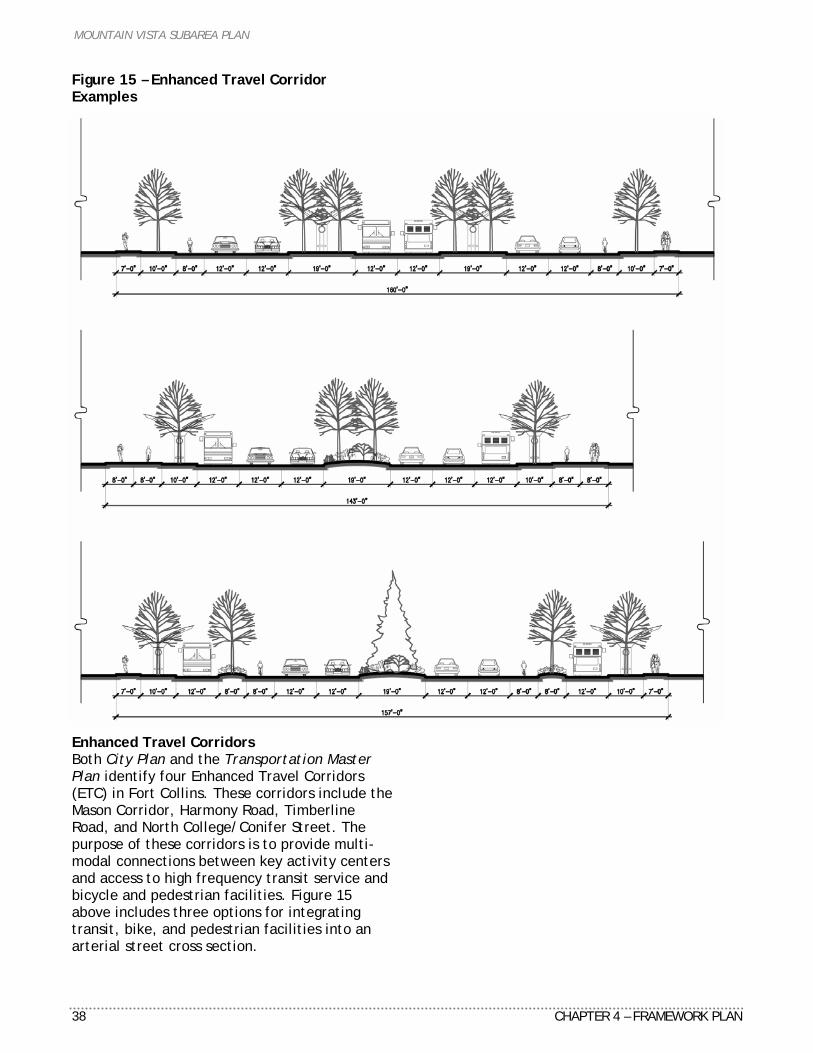
MOUNTAIN VISTA SUBAREA PLAN
38 CHAPTER 4 – FRAMEWORK PLAN
Figure 15 – Enhanced Travel Corridor Examples Enhanced Travel Corridors Both City Plan and the Transportation Master Plan identify four Enhanced Travel Corridors (ETC) in Fort Collins. These corridors include the Mason Corridor, Harmony Road, Timberline Road, and North College/Conifer Street. The purpose of these corridors is to provide multi-modal connections between key activity centers and access to high frequency transit service and bicycle and pedestrian facilities. Figure 15 above includes three options for integrating transit, bike, and pedestrian facilities into an arterial street cross section.
MOUNTAIN VISTA SUBAREA PLAN
CHAPTER 4 – FRAMEWORK PLAN 39
Grade-Separated Crossings Colorado Public Utilities Commission (PUC) regulations stipulate that grade-separated crossings are required for all future 4-lane arterial streets. This requirement is subject to review by the Burlington Northern and Santa Fe Railway’s grade-separated crossing standards. As a result, this Plan includes grade-separated crossings at three locations: Lemay Avenue and existing Vine Drive, Timberline Road and existing Vine Drive, and Mountain Vista Drive. The cost and timing of these crossings are addressed in the infrastructure financing and implementation analysis. Off-Street Trails The Parks & Recreation Policy Plan lays out an extensive network of off-street trails for the community. The 2008 Bicycle Plan recommends off-street trails consistent with the Parks & Recreation Policy Plan. While the 1999 Framework Plan located segments of off-street trails near existing natural areas, a key issues for this update is to relocate these trail alignments away from important natural features. TRANSPORTATION NETWORK CHANGES Refined Street Network The project team analyzed ways to refine this subarea’s existing street network. This included the location and overall number of arterial and collector-level streets. The 1999 Plan included an extensive street network, particularly collector-level streets. The alternatives analysis, including travel demand modeling, indicated the projected traffic volumes can be accommodated on the proposed street network. The refinements attempt to maintain multi-modal connectivity, access, and capacity while responding to land use and other proposed changes. Additional local streets, constructed at the time of development, are not included in the travel demand model or Master Street Plan. Conifer Street Extension The 1999 Plan includes an extension of Conifer Street as a 2-lane arterial street from Lemay Avenue to east of Timberline Road. Conifer Street now ends at Timberline Road instead of extending into the Community Commercial District. The extension was also deemed part of
the Mountain Vista/North College Enhanced Travel Corridor connecting Downtown, North College Avenue, and Mountain Vista. The alignment in the 1999 Plan did not take the location of high-tension power lines into account. The power lines are owned by the Platte River Power Authority and cross the entire subarea. The street alignment is now consistent with current City standards and utility locations. There is on-going public concern about the extension of Conifer Street adversely impacting noise levels, air quality, and attracting additional traffic. Additionally, many residents expressed opinions both in favor and against the extension. Travel demand modeling projected between 7,000 and 8,000 daily trips along Conifer Street between Lemay Avenue and Timberline Road. As such, the street is classified as a 2-lane arterial (two travel lanes with a center turn lane) on the Master Street Plan. As the adjacent areas develop, Conifer Street will serve new residences and provide an important connection as part of the larger street network. The City wants to ensure adequate street, bicycle lane, and sidewalk connections as part of this plan. Turnberry Road Extension Similar concerns and public input have been received about an extension of Turnberry Road. The 1999 Plan included both an extension south to Vine Drive and a new parallel collector street to the east. This new collector street was intended to relieve traffic pressure on Turnberry Road. Area residents must currently use Turnberry Road to access I-25 directly via Mountain Vista Drive. The extension of Country Club Drive (included in both the 1999 and 2009 Plans) will provide additional route choices. Based on these additional route choices, projected travel demand, and the disproportionate impact of an extension on nearby residences, no extension of Turnberry Road is recommended in this plan. Extension of Realigned Vine Drive The 1999 Plan included a realignment of Vine Drive between College and Lemay. This alignment was coordinated with development,
MOUNTAIN VISTA SUBAREA PLAN
40 CHAPTER 4 – FRAMEWORK PLAN
existing neighborhoods, and existing and planned utility corridors. This alignment is also supported in the 2005 Northside Neighborhoods Plan. The 2009 Plan extends this realignment one mile east to Timberline Road to mitigate the impact of the existing alignment on residents, neighborhoods, the railroad, and historic structures. 4-Lane Arterial Street Connectivity The alignments and intersection of Vine Drive, Timberline Road, and Mountain Vista Drive are similar to the 1999 Plan. Several alignment adjustments were made to address changes in the location and size of the community park and Community Commercial District. Timberline Road and Mountain Vista Drive were slightly realigned to accommodate the new location and size of the community park and Community Commercial District. This alignment also takes advantage of existing and planned utility corridors developed in the 1999 Plan. Off-Street Bicycle Trails The bicycle and off-street trail systems are taken directly from the Parks & Recreation Policy Plan. In addition, all new streets will have on-street bicycle lanes and detached sidewalks per the Larimer County Urban Area Street Standards. Existing streets are typically retrofitted along with reconstruction, overlay, or general maintenance projects whenever possible. The 2008 Bicycle Plan, based on the 1999 Plan, is still used for policy and program support. Several neighborhood parks are slated for construction in the next five years, as well as on-going trail work in northeast Fort Collins. Transit Service The recently adopted Transit Strategic Plan continues transit service to this subarea in all three implementation phases. Enhanced Travel Corridor (ETC) service will be provided along realigned Vine Drive via Transfort and developed in a future planning effort. This future ETC service is included in Phase 3 of the 2009 Transit Strategic Plan. Any future modifications to transit service should include access to activity centers like the school, Community Park, Community Commercial District, higher-density housing, and
other destinations within this subarea and Fort Collins. Enhanced Travel Corridors Residents and businesses have long advocated for better mobility within northeast Fort Collins and to the rest of the community. This subarea, a key growth area within the City’s Growth Management Area, is steadily developing with residences and businesses. City Plan, Transportation Master Plan, North College Corridor Plan, and both the 1999 and 2009 Plans examined this issue. A common recommendation from all of these plans was an enhanced travel corridor to serve increased housing and jobs. The 1999 Plan included North College Avenue and Conifer Street as ETCs to serve existing and planned residences, jobs, and entertainment. The ETC also provided a direct connection to the Mason Corridor. The 2009 Plan shifts a portion of the ETC from Conifer Street to realigned Vine Drive. This change allows greater coordination with major utilities, takes advantage of supportive land uses (higher-density housing, pedestrian-oriented commercial center), and provides more direct access to jobs. The Mountain Vista/North College ETC would also connect to the planned Timberline/Power Trail ETC. This ETC would not only provide better mobility in northeast Fort Collins, but could enable regional connections to surrounding communities. Grade-Separated Crossings This Plan recommends three grade-separated railroad crossings in the same location as the 1999 Plan. No major changes are proposed. Right-of-way for these crossings is dedicated along the southeast side of Vine and Lemay (San Cristo) and the southeast side of Timberline and Vine (East Ridge). Whether each crossing will be an overpass or underpass is not a part of this plan’s update. We received extensive public input regarding this decision. The project team recommends the alternative designs analysis will need to include financial, engineering, environmental, noise, and visual impacts at a minimum. Public input for each crossing indicates a strong desire for an
MOUNTAIN VISTA SUBAREA PLAN
CHAPTER 4 – FRAMEWORK PLAN 41
underpass at Lemay and Vine to minimize visual and other impacts to the Alta Vista, Andersonville, Via Lopez, and San Cristo Neighborhoods. There was not a consensus regarding the Timberline and Mountain Vista crossings. The City’s Engineering Department estimated the construction of realigned Vine Drive would delay the need for the Timberline and Lemay grade-separated crossings. The Vine Drive realignment separates the street intersection from the railroad crossing. In the short-term, this would allow additional capacity at both the intersection and crossing. Due to unresolved funding issues, this option should be a priority as property develops and dedicates right-of-way for the extension of realigned Vine Drive. STREET DESIGN RECOMMENDATIONS The project team examined the subarea’s street design. The Larimer County Urban Area Street Standards are the guiding street standards for the City of Fort Collins. This Plan’s recommendations would not supersede the City’s street standards unless they are formally amended through a modification process. Several of these recommendations are also expected to be considered as part of the update to the Transportation Master Plan. Travel Lane Width The City’s standards include a 12-foot lane width for 4-lane arterial streets. The City’s Traffic Engineer indicates an 11-foot travel lane would be acceptable from a safety perspective. Intersection Controls City policy states all types of intersection controls, including roundabouts, must be considered and evaluated. The preferred intersection control is based on providing a safe and efficient transportation network to serve surrounding development and short- and long-range traffic volumes. Street Design Speed The design speed of a street can be adjusted based on the desired posted speed limits. Portions of realigned Vine Drive may have different posted speed limits which would have an impact on street design. However, these
must be an adequate street design speed to ensure traffic safety. Vine Drive – North of the Alta Vista Neighborhood Realigned Vine Drive will be located 100 feet north of the existing neighborhoods between College and Lemay Avenues. This alignment was coordinated with the Alta Vista Neighborhood, utility providers, and the City prior to the 1999 Plan. At that time, the Northeast College Corridor Outfall (NECCO) project was going to be an open channel with landscaping. The NECCO project is now planned as an underground drainage pipe. In an effort to mitigate noise, air quality, and visual impacts to Alta Vista, additional buffering should be considered along the south side of the Vine Drive realignment. DE FACTO TRUCK ROUTE CONCERNS Over the past year, the project team has examined six land use and transportation alternatives. The streets on these alternatives ranged from a series of sharp 90 degree turns, to an almost straight connection from I-25 to College Avenue, to the same streets proposed in the 1999 Plan (as shown on the current Master Street Plan). Each alternative was reviewed by City staff, project consultants, various Boards and Commissions, City Council, and hundreds of Fort Collins residents. As part of this update process, some residents of the Lindenwood Neighborhood expressed concerns about the extension of realigned Vine Drive acting as a de facto truck bypass route alternative to the existing SH 14/US 287 designated through truck route. The project team has, and will continue to address this concern. The project team does not believe the realigned Vine Drive will be a de facto truck bypass route. There is not a large enough speed, travel time, or safety efficiency gained for truck traffic to discontinue use of the SH 14/US 287 truck route. The existing truck route provides a safe, direct, and predictable travel environment for through trucks. In addition, the existing SH 14/US 287 designated through truck route permits vehicle weights up to 30,000 pounds more than on Fort Collins streets.
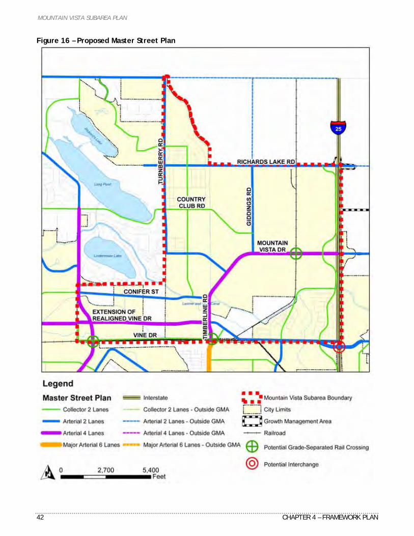
MOUNTAIN VISTA SUBAREA PLAN
42 CHAPTER 4 – FRAMEWORK PLAN
Figure 16 – Proposed Master Street Plan
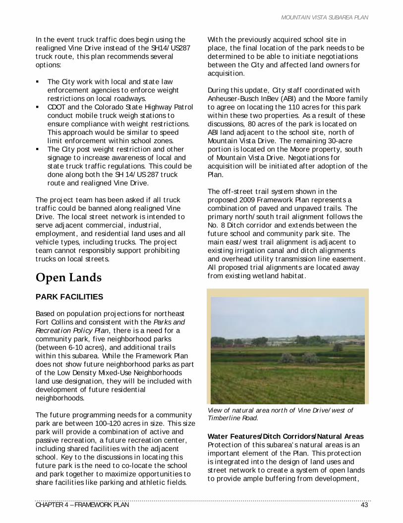
MOUNTAIN VISTA SUBAREA PLAN
CHAPTER 4 – FRAMEWORK PLAN 43
In the event truck traffic does begin using the realigned Vine Drive instead of the SH14/US287 truck route, this plan recommends several options: The City work with local and state law
enforcement agencies to enforce weight restrictions on local roadways.
CDOT and the Colorado State Highway Patrol conduct mobile truck weigh stations to ensure compliance with weight restrictions. This approach would be similar to speed limit enforcement within school zones.
The City post weight restriction and other signage to increase awareness of local and state truck traffic regulations. This could be done along both the SH 14/US 287 truck route and realigned Vine Drive.
The project team has been asked if all truck traffic could be banned along realigned Vine Drive. The local street network is intended to serve adjacent commercial, industrial, employment, and residential land uses and all vehicle types, including trucks. The project team cannot responsibly support prohibiting trucks on local streets.
Open Lands PARK FACILITIES Based on population projections for northeast Fort Collins and consistent with the Parks and Recreation Policy Plan, there is a need for a community park, five neighborhood parks (between 6-10 acres), and additional trails within this subarea. While the Framework Plan does not show future neighborhood parks as part of the Low Density Mixed-Use Neighborhoods land use designation, they will be included with development of future residential neighborhoods. The future programming needs for a community park are between 100–120 acres in size. This size park will provide a combination of active and passive recreation, a future recreation center, including shared facilities with the adjacent school. Key to the discussions in locating this future park is the need to co-locate the school and park together to maximize opportunities to share facilities like parking and athletic fields.
With the previously acquired school site in place, the final location of the park needs to be determined to be able to initiate negotiations between the City and affected land owners for acquisition. During this update, City staff coordinated with Anheuser-Busch InBev (ABI) and the Moore family to agree on locating the 110 acres for this park within these two properties. As a result of these discussions, 80 acres of the park is located on ABI land adjacent to the school site, north of Mountain Vista Drive. The remaining 30-acre portion is located on the Moore property, south of Mountain Vista Drive. Negotiations for acquisition will be initiated after adoption of the Plan. The off-street trail system shown in the proposed 2009 Framework Plan represents a combination of paved and unpaved trails. The primary north/south trail alignment follows the No. 8 Ditch corridor and extends between the future school and community park site. The main east/west trail alignment is adjacent to existing irrigation canal and ditch alignments and overhead utility transmission line easement. All proposed trial alignments are located away from existing wetland habitat.
View of natural area north of Vine Drive/west of Timberline Road.
Water Features/Ditch Corridors/Natural Areas Protection of this subarea’s natural areas is an important element of the Plan. This protection is integrated into the design of land uses and street network to create a system of open lands to provide ample buffering from development,
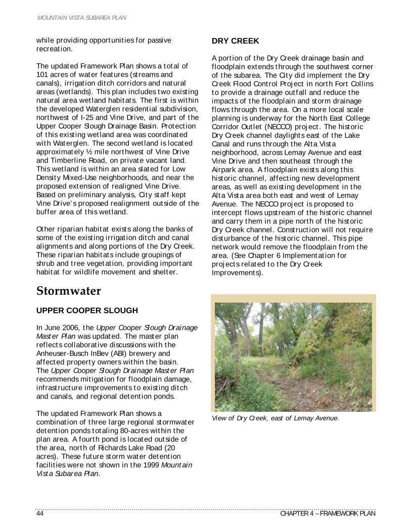
MOUNTAIN VISTA SUBAREA PLAN
44 CHAPTER 4 – FRAMEWORK PLAN
while providing opportunities for passive recreation. The updated Framework Plan shows a total of 101 acres of water features (streams and canals), irrigation ditch corridors and natural areas (wetlands). This plan includes two existing natural area wetland habitats. The first is within the developed Waterglen residential subdivision, northwest of I-25 and Vine Drive, and part of the Upper Cooper Slough Drainage Basin. Protection of this existing wetland area was coordinated with Waterglen. The second wetland is located approximately ½ mile northwest of Vine Drive and Timberline Road, on private vacant land. This wetland is within an area slated for Low Density Mixed-Use neighborhoods, and near the proposed extension of realigned Vine Drive. Based on preliminary analysis, City staff kept Vine Drive’s proposed realignment outside of the buffer area of this wetland. Other riparian habitat exists along the banks of some of the existing irrigation ditch and canal alignments and along portions of the Dry Creek. These riparian habitats include groupings of shrub and tree vegetation, providing important habitat for wildlife movement and shelter.
Stormwater UPPER COOPER SLOUGH In June 2006, the Upper Cooper Slough Drainage Master Plan was updated. The master plan reflects collaborative discussions with the Anheuser-Busch InBev (ABI) brewery and affected property owners within the basin. The Upper Cooper Slough Drainage Master Plan recommends mitigation for floodplain damage, infrastructure improvements to existing ditch and canals, and regional detention ponds. The updated Framework Plan shows a combination of three large regional stormwater detention ponds totaling 80-acres within the plan area. A fourth pond is located outside of the area, north of Richards Lake Road (20 acres). These future storm water detention facilities were not shown in the 1999 Mountain Vista Subarea Plan.
DRY CREEK A portion of the Dry Creek drainage basin and floodplain extends through the southwest corner of the subarea. The City did implement the Dry Creek Flood Control Project in north Fort Collins to provide a drainage outfall and reduce the impacts of the floodplain and storm drainage flows through the area. On a more local scale planning is underway for the North East College Corridor Outlet (NECCO) project. The historic Dry Creek channel daylights east of the Lake Canal and runs through the Alta Vista neighborhood, across Lemay Avenue and east Vine Drive and then southeast through the Airpark area. A floodplain exists along this historic channel, affecting new development areas, as well as existing development in the Alta Vista area both east and west of Lemay Avenue. The NECCO project is proposed to intercept flows upstream of the historic channel and carry them in a pipe north of the historic Dry Creek channel. Construction will not require disturbance of the historic channel. This pipe network would remove the floodplain from the area. (See Chapter 6 Implementation for projects related to the Dry Creek Improvements).
View of Dry Creek, east of Lemay Avenue.
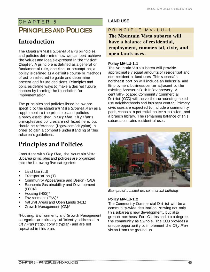
MOUNTAIN VISTA SUBAREA PLAN
CHAPTER 5 – PRINCIPLES AND POLICIES 45
C H A P T E R 5
PRINCIPLES AND POLICIES
Introduction The Mountain Vista Subarea Plan’s principles and policies determine how we can best achieve the values and ideals expressed in the “Vision” Chapter. A principle is defined as a general or fundamental rule, doctrine, or assumption; a policy is defined as a definite course or methods of action selected to guide and determine present and future decisions. Principles and policies define ways to make a desired future happen by forming the foundation for implementation. The principles and policies listed below are specific to the Mountain Vista Subarea Plan as a supplement to the principles and policies already established in City Plan. City Plan’s principles and policies are not listed here, but should be referenced (fcgov.com/cityplan) in order to gain a complete understanding of this subarea’s guidelines.
Principles and Policies Consistent with City Plan, the Mountain Vista Subarea principles and policies are organized into the following five categories: Land Use (LU) Transportation (T) Community Appearance and Design (CAD) Economic Sustainability and Development
(ECON) Housing (HSG)* Environment (ENV)* Natural Areas and Open Lands (NOL) Growth Management (GM)*
*Housing, Environment, and Growth Management categories are already sufficiently addressed in City Plan (fcgov.com/cityplan) and are not repeated in this plan.
LAND USE P R I N C I P L E M V - L U - 1
The Mountain Vista subarea will have a balance of residential, employment, commercial, civic, and open lands uses. Policy MV-LU-1.1 The Mountain Vista subarea will provide approximately equal amounts of residential and non-residential land uses. This subarea’s northeast portion will include an Industrial and Employment business center adjacent to the existing Anheuser-Bush InBev brewery. A centrally-located Community Commercial District (CCD) will serve the surrounding mixed-use neighborhoods and business center. Primary civic uses are expected to include a community park, schools, a potential police substation, and a branch library. The remaining balance of this subarea contains residential uses.
Example of a mixed-use commercial building. Policy MV-LU-1.2 The Community Commercial District will be a community-wide destination, serving not only this subarea’s new development, but also greater northeast Fort Collins and, to a degree, the community as a whole. The CCD provides a unique opportunity to implement the City Plan vision from the ground up.
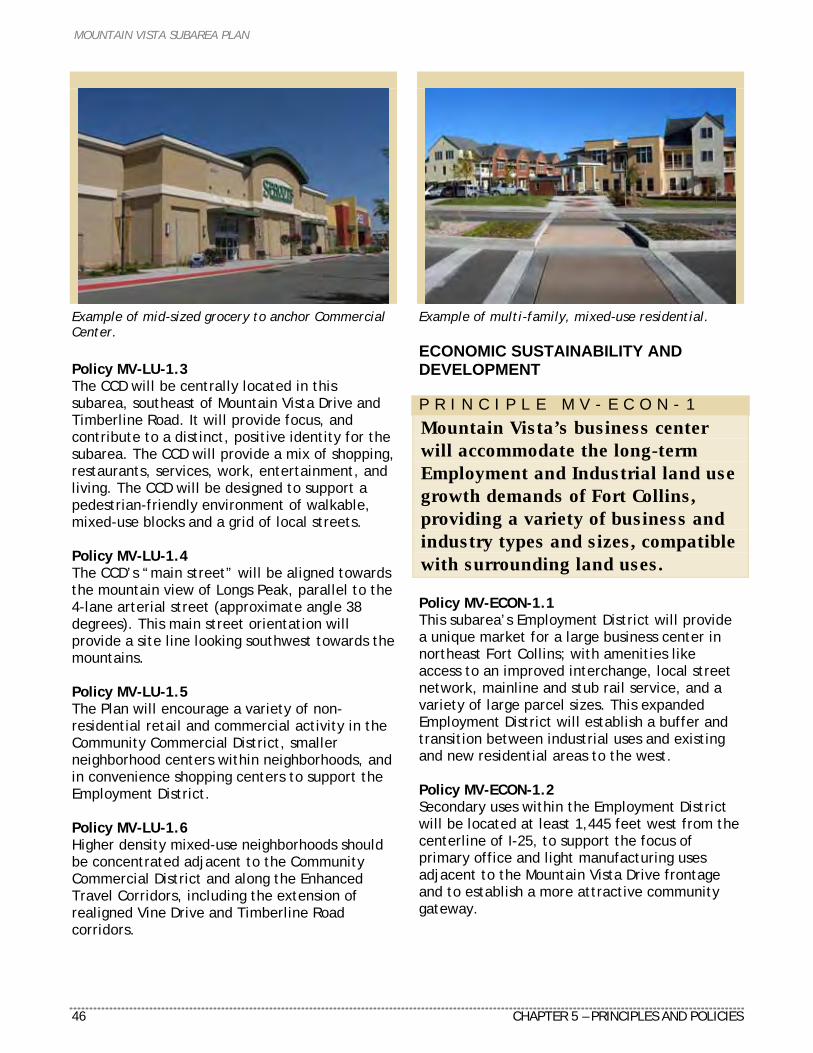
MOUNTAIN VISTA SUBAREA PLAN
46 CHAPTER 5 – PRINCIPLES AND POLICIES
Example of mid-sized grocery to anchor Commercial Center.
Policy MV-LU-1.3 The CCD will be centrally located in this subarea, southeast of Mountain Vista Drive and Timberline Road. It will provide focus, and contribute to a distinct, positive identity for the subarea. The CCD will provide a mix of shopping, restaurants, services, work, entertainment, and living. The CCD will be designed to support a pedestrian-friendly environment of walkable, mixed-use blocks and a grid of local streets. Policy MV-LU-1.4 The CCD’s “main street” will be aligned towards the mountain view of Longs Peak, parallel to the 4-lane arterial street (approximate angle 38 degrees). This main street orientation will provide a site line looking southwest towards the mountains. Policy MV-LU-1.5 The Plan will encourage a variety of non-residential retail and commercial activity in the Community Commercial District, smaller neighborhood centers within neighborhoods, and in convenience shopping centers to support the Employment District. Policy MV-LU-1.6 Higher density mixed-use neighborhoods should be concentrated adjacent to the Community Commercial District and along the Enhanced Travel Corridors, including the extension of realigned Vine Drive and Timberline Road corridors.
Example of multi-family, mixed-use residential. ECONOMIC SUSTAINABILITY AND DEVELOPMENT P R I N C I P L E M V - E C O N - 1
Mountain Vista’s business center will accommodate the long-term Employment and Industrial land use growth demands of Fort Collins, providing a variety of business and industry types and sizes, compatible with surrounding land uses. Policy MV-ECON-1.1 This subarea’s Employment District will provide a unique market for a large business center in northeast Fort Collins; with amenities like access to an improved interchange, local street network, mainline and stub rail service, and a variety of large parcel sizes. This expanded Employment District will establish a buffer and transition between industrial uses and existing and new residential areas to the west. Policy MV-ECON-1.2 Secondary uses within the Employment District will be located at least 1,445 feet west from the centerline of I-25, to support the focus of primary office and light manufacturing uses adjacent to the Mountain Vista Drive frontage and to establish a more attractive community gateway.
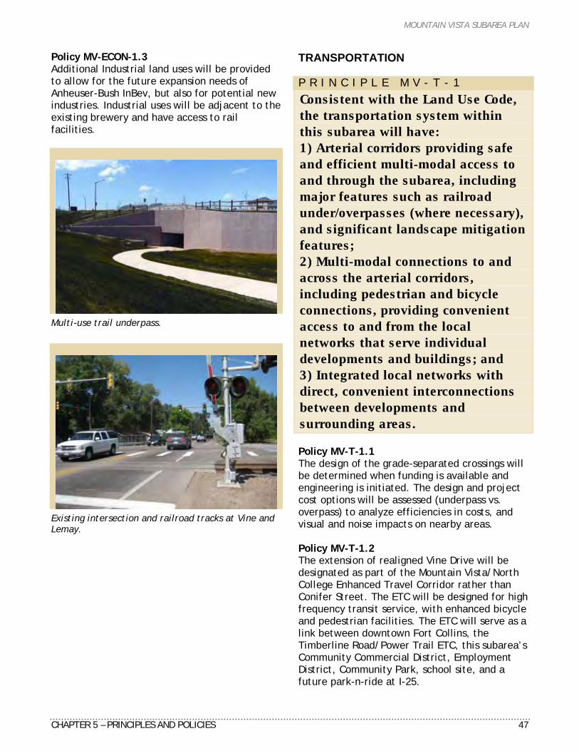
MOUNTAIN VISTA SUBAREA PLAN
CHAPTER 5 – PRINCIPLES AND POLICIES 47
Policy MV-ECON-1.3 Additional Industrial land uses will be provided to allow for the future expansion needs of Anheuser-Bush InBev, but also for potential new industries. Industrial uses will be adjacent to the existing brewery and have access to rail facilities.
Multi-use trail underpass.
Existing intersection and railroad tracks at Vine and Lemay.
TRANSPORTATION P R I N C I P L E M V - T - 1
Consistent with the Land Use Code, the transportation system within this subarea will have: 1) Arterial corridors providing safe and efficient multi-modal access to and through the subarea, including major features such as railroad under/overpasses (where necessary), and significant landscape mitigation features; 2) Multi-modal connections to and across the arterial corridors, including pedestrian and bicycle connections, providing convenient access to and from the local networks that serve individual developments and buildings; and 3) Integrated local networks with direct, convenient interconnections between developments and surrounding areas. Policy MV-T-1.1 The design of the grade-separated crossings will be determined when funding is available and engineering is initiated. The design and project cost options will be assessed (underpass vs. overpass) to analyze efficiencies in costs, and visual and noise impacts on nearby areas. Policy MV-T-1.2 The extension of realigned Vine Drive will be designated as part of the Mountain Vista/North College Enhanced Travel Corridor rather than Conifer Street. The ETC will be designed for high frequency transit service, with enhanced bicycle and pedestrian facilities. The ETC will serve as a link between downtown Fort Collins, the Timberline Road/Power Trail ETC, this subarea’s Community Commercial District, Employment District, Community Park, school site, and a future park-n-ride at I-25.
MOUNTAIN VISTA SUBAREA PLAN
48 CHAPTER 5 – PRINCIPLES AND POLICIES
Policy MV-T-1.3 A future planning effort will establish the function and design of the Mountain Vista/North College ETC. The design and development standards for the ETC will be coordinated with the I-25/Mountain Vista Drive Gateway corridor. Policy MV-T-1.4 Bicycle and pedestrian facilities, both on- and off-street, will be developed to link this subarea to downtown Fort Collins and Poudre River Trail. These connections will link to the comprehensive city- and region-wide bicycle, pedestrian, and transit systems. Policy MV-T-1.5 The location and classification of streets in this subarea will comply with the updated Master Street Plan based on the recommendations in this Plan. P R I N C I P L E M V - T - 2
Mountain Vista’s Employment and Community Commercial Districts will both be based on transit-oriented design. Policy MV-T-2.1 The Community Commercial District will serve as this subarea’s public transit hub. The CCD will be the focal point of an efficient and integrated transit network serving all residential, commercial, and employment areas of Mountain Vista, as well as provide connections to other transit hubs within Fort Collins and the region. The Community Commercial District should provide higher density mixed-use residential in conjunction with retail, office, civic, and other uses to support the transit system. Policy MV-T-2.2 Transit service should also be provided between this subarea and the Harmony Corridor Employment District by way of I-25. Park and rides and transit stations should be provided adjacent to the I-25 interchange area.
P R I N C I P L E M V - T - 3
The Community Commercial District will be designed with an emphasis on pedestrians. Policy MV-T-3.1 The CCD’s local street network will be designed to maximize a town-like pattern of blocks, building frontage, and on-street parking. For these streets, standards will emphasize the urban form and the pedestrian environment. Vehicle access and flow will be accommodated, but will not override the design of the pedestrian street fronts. Possible elements of the design may include slow speed limits, angled on-street parking, wider lanes (with maneuvering room for bicycles), medians with pedestrian refuges, and curb extensions at corners. Policy MV-T-3.2 The design of the Community Commercial District will support active street fronts with buildings and their entrances along main streets. If angled parking (on selected main streets) makes dedicated bicycle lanes infeasible, then special consideration will be given to bicycle lanes leading to and around those streets. Also, wider lanes should be considered on the main streets to allow more room for bicyclists to share the slow-speed streets with vehicles. P R I N C I P L E M V - T - 4
The City will consider a variety of street design and enforcement methods to ensure realigned Vine Drive does not become a truck route, either intended or unintended. Policy MV-T-4.1 The City will include the following recommended street design elements: narrower travel lane width, a variety of intersection controls, lower street design speeds, traffic calming on local streets, and appropriate signage. These recommended elements will be coordinated with the City Traffic Engineer and City Engineer to ensure that the final street

MOUNTAIN VISTA SUBAREA PLAN
CHAPTER 5 – PRINCIPLES AND POLICIES 49
design does not compromise the function, efficiency, and safety of the overall street network. Policy MV-T-4.2 In the event that through truck traffic begins using realigned Vine Drive as a de facto truck route, the City will pursue the following enforcement methods: vehicle weight limitation enforcement with Fort Collins Police and Colorado State Highway Patrol, mobile weigh stations, and appropriate signage along realigned Vine Drive and the existing SH 14/US 287 designated through truck route. COMMUNITY APPEARANCE AND DESIGN P R I N C I P L E M V - C A D - 1
Important views toward the nearby mountains should be preserved and emphasized by the arrangement and design of development. Policy MV-CAD-1.1 Key subarea streets, where appropriate, should be oriented southwest to allow development to provide mountain views. Policy MV-CAD-1.2 Developers and architects will be encouraged to arrange buildings, outdoor spaces, and parking lots to protect important view corridors, including limiting building heights, where such arrangements are effective in emphasizing vistas of the mountains. Policy MV-CAD-1.3 The layout of the Community Commercial District street pattern and building placement will be designed to maximize view site lines towards the mountains. P R I N C I P L E M V - C A D - 2
Mountain Vista’s community gateway from I-25 should be designed to provide a sense of place and positive experience.
Policy MV-CAD-2.1 The Mountain Vista Drive corridor heading west from I-25 will establish a northeast gateway supported by a primary land use designation of Employment adjacent to the arterial street corridor between I-25 and Giddings Road. A focus of corporate office uses will be located along the Mountain Vista Drive frontage, with parking areas and light manufacturing facilities located behind these office developments. Policy MV-CAD-2.2 Gateway design and development standards should be established for the I-25/Mountain Vista Drive corridor. These standards should reflect a positive entryway appearance with quality building and site design, landscaping setbacks within the public street right-of-way and between the street and development, and appropriate entry features and signage to enhance this community entryway. P R I N C I P L E M V - C A D - 3
The preservation of existing historic resources, such as homes and the Plummer School, will be encouraged. Policy MV-CAD-3.1 The historic Plummer School will be preserved and protected. The grade-separated crossing at Timberline Road will not impact the Plummer School property. Policy MV-CAD-3.2 Other existing neighborhoods and properties adjacent to Vine Drive will be coordinated with any future City street widening and realignment of Lemay Avenue to minimize impacts to these existing developments. HOUSING Housing is already sufficiently addressed in City Plan (fcgov.com/cityplan) and not detailed in this plan. ENVIRONMENT Environment is already sufficiently addressed in City Plan (fcgov.com/cityplan) and not detailed in this plan.
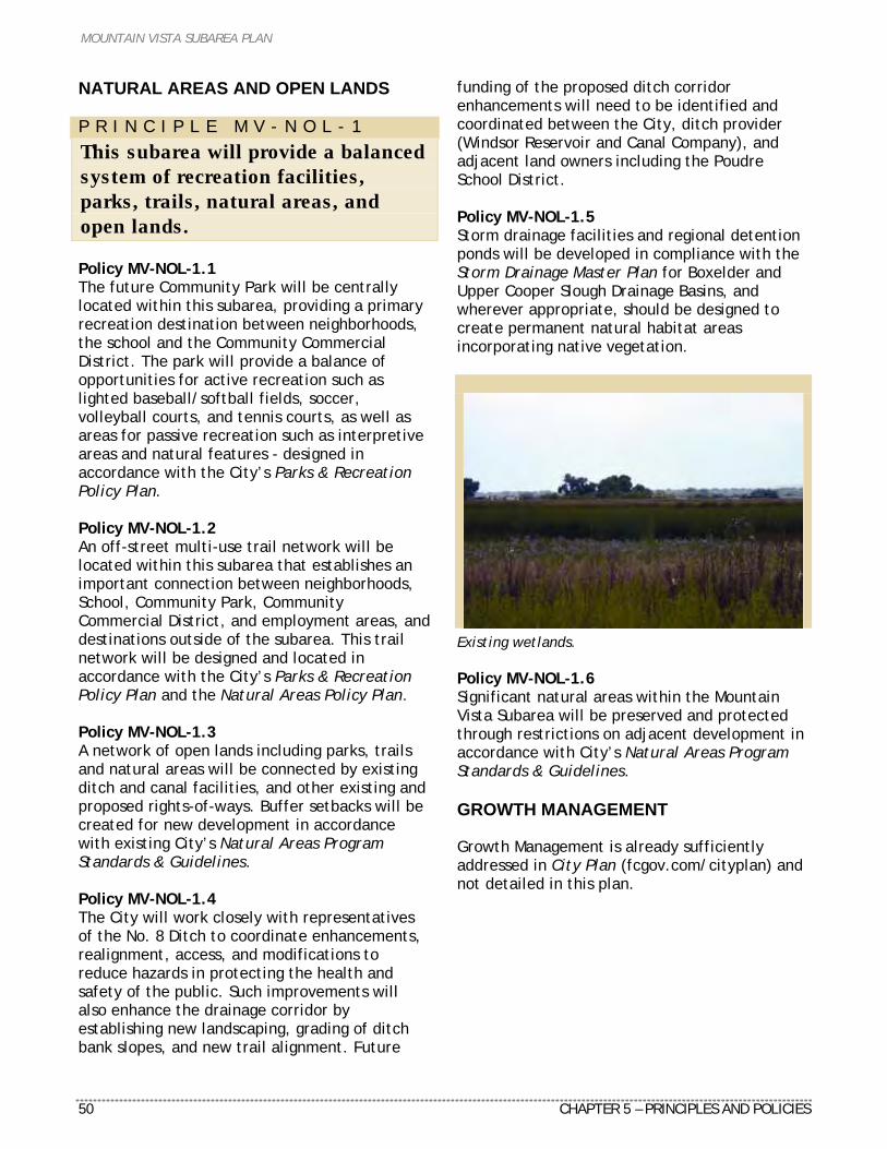
MOUNTAIN VISTA SUBAREA PLAN
50 CHAPTER 5 – PRINCIPLES AND POLICIES
NATURAL AREAS AND OPEN LANDS P R I N C I P L E M V - N O L - 1
This subarea will provide a balanced system of recreation facilities, parks, trails, natural areas, and open lands. Policy MV-NOL-1.1 The future Community Park will be centrally located within this subarea, providing a primary recreation destination between neighborhoods, the school and the Community Commercial District. The park will provide a balance of opportunities for active recreation such as lighted baseball/softball fields, soccer, volleyball courts, and tennis courts, as well as areas for passive recreation such as interpretive areas and natural features - designed in accordance with the City’s Parks & Recreation Policy Plan. Policy MV-NOL-1.2 An off-street multi-use trail network will be located within this subarea that establishes an important connection between neighborhoods, School, Community Park, Community Commercial District, and employment areas, and destinations outside of the subarea. This trail network will be designed and located in accordance with the City’s Parks & Recreation Policy Plan and the Natural Areas Policy Plan. Policy MV-NOL-1.3 A network of open lands including parks, trails and natural areas will be connected by existing ditch and canal facilities, and other existing and proposed rights-of-ways. Buffer setbacks will be created for new development in accordance with existing City’s Natural Areas Program Standards & Guidelines. Policy MV-NOL-1.4 The City will work closely with representatives of the No. 8 Ditch to coordinate enhancements, realignment, access, and modifications to reduce hazards in protecting the health and safety of the public. Such improvements will also enhance the drainage corridor by establishing new landscaping, grading of ditch bank slopes, and new trail alignment. Future
funding of the proposed ditch corridor enhancements will need to be identified and coordinated between the City, ditch provider (Windsor Reservoir and Canal Company), and adjacent land owners including the Poudre School District. Policy MV-NOL-1.5 Storm drainage facilities and regional detention ponds will be developed in compliance with the Storm Drainage Master Plan for Boxelder and Upper Cooper Slough Drainage Basins, and wherever appropriate, should be designed to create permanent natural habitat areas incorporating native vegetation.
Existing wetlands. Policy MV-NOL-1.6 Significant natural areas within the Mountain Vista Subarea will be preserved and protected through restrictions on adjacent development in accordance with City’s Natural Areas Program Standards & Guidelines. GROWTH MANAGEMENT Growth Management is already sufficiently addressed in City Plan (fcgov.com/cityplan) and not detailed in this plan.
MOUNTAIN VISTA SUBAREA PLAN
CHAPTER 6 – IMPLEMENTATION RECOMMENDATIONS 51
C H A P T E R 6
IMPLEMENTATION RECOMMENDATIONS Introduction A key aspect of any plan is how it gets implemented. This chapter highlights the key implementation actions needed to achieve the Plan. A variety of standards and requirements, policies, and capital improvement programs are recommended to make the Mountain Vista Subarea Plan a reality. These recommendations draw on a review of City Plan, examination of City policies regarding infrastructure im-provements and financing, and consultation with City staff and consultants (see Figure 20). This chapter also includes a detailed listing of projects and associated costs needed to implement this area’s development, including transportation improvements, parks and trails, natural areas, stormwater drainage, and public facilities. Figure 19 identifies estimated cost estimates of each improvement and recommending the probable source of funds. This chapter also includes an analysis of select infrastructure projects needed to alleviate adequate public facilities issues. The implementation action plan highlights key recommendations, capital projects, and other actions needed to achieve the Plan vision (see Figure 22).
Implementation Actions since the 1999 Plan Adoption AMENDMENTS TO EXISTING CITY MAPS In 1999, the City Structure Plan, Zoning, and Master Street Plan maps were concurrently amended with adoption of the Mountain Vista Subarea Plan. These documents translated the plan’s recommendations from policies into regulations to guide future development (see Figure 21).
LAND USE CODE The 1999 Mountain Vista Subarea Plan included several land use recommendations to discourage “strip commercial” and incompatible residential development. The adopted changes to the Land Use Code include a ¼-mile setback from I-25 for secondary uses in the Employment District and a ¼-mile setback from the centerline of I-25 for residential uses. STORMWATER In June 2006, the Upper Cooper Slough Drainage Master Plan was updated. The master plan reflects collaborative discussions with the Anheuser-Busch InBev (ABI) brewery and affected property owners within the basin. The Upper Cooper Slough Drainage Basin Master Plan recommends mitigation for floodplain damage, infrastructure improvements to existing ditches, canals and roadways, and three detention ponds. The updated Framework Plan shows a combination of three large regional stormwater detention ponds totaling 80-acres within the plan area. OFF-STREET TRAILS AND PARKS City Parks Planning has coordinated the location of off-street trail alignments and neighborhood parks as new development has occurred. Developing these parks and trail sections will happen as funding becomes available. A regional trail underpass was installed on Richards Lake Road (east of Turnberry Road) as part of the Lind and Maple Hill neighborhoods. POUDRE SCHOOL DISTRICT The Poudre School District acquired about 108 acres north of Mountain Vista Drive, and set this property aside for future school needs. The future needs for PSD for this property are projected to include an elementary, junior high, and high school.
MOUNTAIN VISTA SUBAREA PLAN
52 CHAPTER 6 – IMPLEMENTATION RECOMMENDATIONS
Implementation Actions concurrent with 2009 Plan Adoption As part of the 2009 Mountain Vista Subarea Plan update, the following existing documents will be amended concurrent with adoption: City Structure Plan North College Corridor Plan Framework Northside Neighborhoods Plan Framework Master Street Plan
Based on the recommendations from the proposed 2009 Framework Plan map land use designations, amendments to the City Structure Plan map is needed to establish consistency between the Mountain Vista Subarea Plan and City Plan. The North College Corridor Plan amendment represents a minor housekeeping change to relocate the Enhanced Travel Corridor designation from Conifer Street to realigned Vine Drive (between College Avenue and Lemay Avenue). The Northside Neighborhoods Plan boundary overlaps the Mountain Vista Subarea Plan between the existing and proposed Lemay Avenue alignments. The proposed amendment to the Northside Neighborhoods Plan includes a change of land use from Low Density Mixed-Use Neighborhoods (LMN) to Medium Density Mixed-Use Neighborhoods (MMN), totaling 54 acres. The remaining proposed amendments to the Master Street Plan map also represent adjustments based in the 2009 Mountain Vista Subarea Plan recommendations. An update to City Plan and the Transportation Master Plan will occur in 2009-10. The recommendations of the Mountain Vista Subarea Plan will be included in this planning process.
Implementation Actions after Plan Adoption Several implementation actions will occur after the 2009 Plan has been adopted, estimated to occur within 1-5 years (see Figure 22). The responsible City department, implementation timeframe, and any funding sources are identified below. REZONINGS The first implementation action will be considered for adoption in fall 2009. This action relates to the rezoning of portions of the subarea, based on the Framework Plan land use recommendations. A few additional months were needed to complete the required legal descriptions for each rezoning area. GATEWAY CORRIDOR DESIGN STANDARDS The Mountain Vista Drive corridor west of I-25 represents a key gateway into Fort Collins. Similar to other gateway corridors in the city, a plan addressing landscape, setback, and other design standards will be developed. The City’s Advance Planning Department and Anheuser-Busch InBev will work cooperatively on the gateway standards. The gateway corridor standards are expected to be developed in the next two years, and closely coordinated with the Enhanced Travel Corridor Plan mentioned below. MOUNTAIN VISTA/NORTH COLLEGE ENHANCED TRAVEL CORRIDOR PLAN A separate planning process consistent with Federal Transit Administration (FTA) requirements will address the future Mountain Vista/North College Enhanced Travel Corridor. The City’s Transportation Planning Department, is actively pursuing funding to initiate this corridor planning process. The ETC planning process is anticipated to begin within the next two years.
MOUNTAIN VISTA SUBAREA PLAN
CHAPTER 6 – IMPLEMENTATION RECOMMENDATIONS 53
Future Infrastructure Improvement Projects and Financing The Plan update identifies a list of infrastructure projects and associated costs. A majority of these projects will be funded by future development including the area’s future street network and storm drainage improvements (see Figures 19 and 22). The remaining list of projects are critical to removing constraints to new development related to providing adequate public facilities, as discussed later in this Chapter. Figures 19 and 20 summarize the key recommended transportation and stormwater infrastructure projects in the Mountain Vista subarea. The table includes the total cost of the project, identified funding sources, and an estimated timeframe for construction. The majority of funding for these projects comes from existing development impact fees. The timing of these projects will be dependent on new development moving forward. TRANSPORTATION PROJECTS The proposed 2009 Framework Plan map recommendations, and resulting adjustments to the Master Street Plan, include a list of street infrastructure improvement projects (see Figures 19 and 22). The street improvements include refinements to the overall street network, extension of realigned Vine Drive, and future grade separated railroad crossings. STORMWATER PROJECTS The Upper Cooper Slough Drainage Master Plan and Dry Creek Improvement Project identify a list of recommended stormwater projects in the Mountain Vista subarea. The estimated costs, potential funding sources, and timeframe can be found in Figures 19 and 22. Funding for the projects will be from the City and from new development.
FUNDING OPTIONS There are several funding options available for the projects summarized in Figure 19. Multiple funding options can work for each project. The recommendations to implement the Framework Plan will be primarily funded by a combination of City Capital Improvement Plan funds, development exactions, and street oversizing impact fees. Three funding options were identified as part of this update process. Continue to Utilize Development Impact Fees This approach would rely on development impact fees to fund the infrastructure improvement projects listed in Figures 19 and 22. This can include both existing and new impact fees. Due to development restrictions related to APF requirements, this may require many years of collecting funds. If all of these funds are directed towards the subarea, this could result in less available funding for other parts of the community. This approach would collect funding over a long period of time, but share the project cost among the largest geographic area. Development impact fees are assessed on a city-wide basis based on the street network shown in the Master Street Plan and land uses shown in the City Structure Plan. As a future implementation action, City Engineering staff will update the development impact fee based on the Mountain Vista framework map. Capital Funding Request The projects could be funded as part of a citizen-supported sales tax initiative. This was proposed for the grade-separated crossings in the past, but was rejected due to the financial limitations it imposed on other infrastructure projects. Collective Funding Strategy The City could initiate a special assessment or similar process to provide funding for the NECCO and realigned Vine Drive projects. This approach is currently under review by the City and North College Avenue business owners for the North College Capital Improvements Funding Plan. Several property owners in the Mountain Vista subarea expressed an interest in developing a similar plan. This approach would not be suitable for the grade-separated crossings. Limiting this strategy to the Mountain Vista area
MOUNTAIN VISTA SUBAREA PLAN
54 CHAPTER 6 – IMPLEMENTATION RECOMMENDATIONS
would not fairly share the project costs to benefiting development. KEY ADEQUATE PUBLIC FACILITIES PROJECTS City staff analyzed infrastructure costs and timing for key infrastructure projects that would help remove impediments to development as envisioned in the Plan. The adequate public facilities (APF) regulation ensures development provides the necessary infrastructure and services to mitigate any impact. There is presently limited ability to develop land in the subarea due to lack of APF. This is largely due to constraints surrounding the Lemay Avenue/existing Vine Drive and Timberline Road/existing Vine Drive intersections. These constraints include existing neighborhoods, businesses, residential properties, Plummer School, and the BNSF rail tracks and switching yard. These constraints combine to limit the City’s ability to widen these intersections to increase traffic capacity. Several developments, such as Maple Hill and Lind, have received City approval but are still under construction. Additional phases of these projects will be constructed but not violate the APF regulation. As part of the 1999 Plan, a preliminary infrastructure analysis identified a large number of capital projects required to alleviate the APF issues. However, after clarifying and analyzing needed transportation and drainage projects with this 2009 Plan update process, only a handful must be completed to allow development to proceed. The existing Dry Creek Floodplain limits most residential development from proceeding in the current floodway. While the planned Northeast College Corridor Outfall (NECCO) project is listed with the other transportation APF projects, this storm drainage improvement project is somewhat different. Some new development can take place now and still meet the City drainage and floodplain criteria. However, full development of the area can not occur until the entire NECCO project is implemented to provide appropriate outfall of area and removal of the existing floodplain.
Adequate public facilities will continue to be issue until the grade-separated crossings (GSC) are constructed in the long-term. Due to the cost and financing of the GSCs, several projects were identified that can be constructed in the short- and medium-term to address APF issues, delay the need for GSCs, and allow development to move forward. Priority of phasing, estimates of project costs, and how much population and job growth are provided in Figure 17. The location and magnitude of any development will depend on traffic impacts determined at the time of construction. Please see Figure 18 for a map of the APF projects. Staff has developed a sequence below for the timing of implementing these large capital improvement projects (in order of importance): Realigned Vine Arterial (College to Lemay): The timing to implement the proposed realigned Vine Drive arterial street between College Avenue and Lemay Avenue is a critical first phase in removing existing APF impediments in this area. While this project is mostly located outside of the Mountain Vista subarea, implementation of this project in important to reduce traffic volumes at the existing Vine/Lemay intersection and provide additional street and intersection capacity to and from the Mountain Vista Subarea. If constructed, this project would delay the need to implement the future grade separated crossing at Vine/Lemay for several years. The estimated population and jobs growth are dependent on concurrent construction of Northeast College Corridor Outfall drainage improvements (see Figure 17). Realigned Vine Arterial (Lemay to Timberline): Construction of the extension of the Vine Drive realignment between Lemay and Timberline would allow additional development to comply with APF requirements in the Mountain Vista subarea. Over time, the Timberline and existing Vine intersection will become more congested. This project would have the same benefits of reduced volumes at the existing intersection and creating new street and intersection capacity. As mentioned previously, if this segment of realigned Vine Drive is constructed, it would further delay the need to implement the grade separated crossing at the Vine Drive/Timberline Road intersection.
MOUNTAIN VISTA SUBAREA PLAN
CHAPTER 6 – IMPLEMENTATION RECOMMENDATIONS 55
Northeast College Corridor Outfall (NECCO) Storm Drainage Project A portion of the Dry Creek Floodway remains in the western part of the subarea, limiting future residential development. This floodway results from a combination of factors associated with partially built drainage improvements. The City’s Stormwater Utility has final design of needed improvements to remove the floodplain. Partial improvements are possible within the western portion of the subarea, but to ultimately remove the floodway, significant drainage facilities are needed upstream as well (west of Lemay Avenue to North College Avenue). The estimated population and jobs growth are dependent on concurrent construction of the realignment of Vine Drive between College and Lemay. Grade-Separated Crossings The Colorado Public Utilities Commission will ultimately require three grade-separated railroad crossings (GSC) at the Lemay Avenue/Vine Drive, Timberline Road/Vine Drive intersections, and Mountain Vista Drive when traffic volumes warrant a 4-lane street crossing. This requirement would likely occur first at the Lemay Avenue/Vine Drive crossing, and then at Timberline Road/Vine Drive. The realignment of Vine Drive from College to Timberline would delay the need for the crossings in the short-term. These projects would also allow a substantial amount of development to occur in the long-term. The timing of when the GSC would be triggered at Mountain Vista Drive is dependent on future development around this crossing and related traffic impacts.
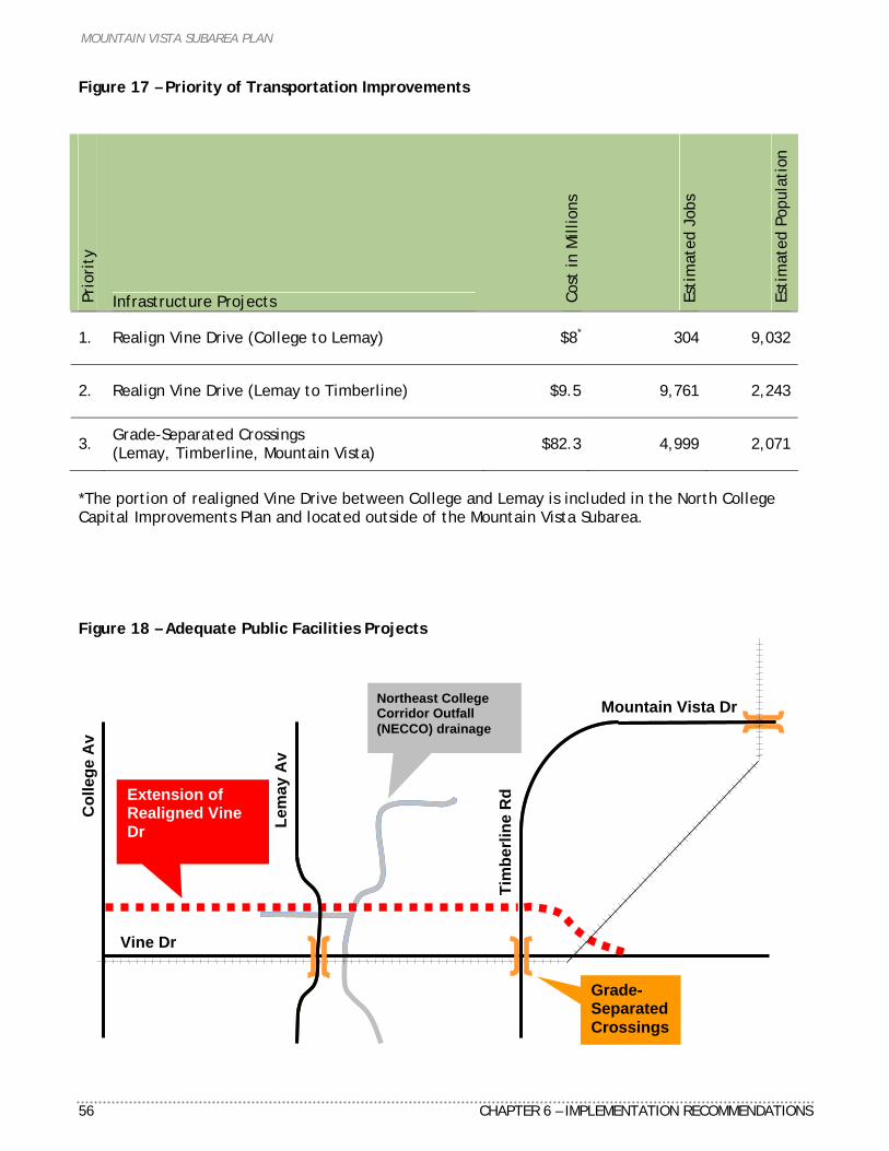
MOUNTAIN VISTA SUBAREA PLAN
56 CHAPTER 6 – IMPLEMENTATION RECOMMENDATIONS
Figure 17 – Priority of Transportation Improvements
Prio
rity
Infrastructure Projects Cost
in M
illio
ns
Esti
mat
ed J
obs
Esti
mat
ed P
opul
atio
n
1. Realign Vine Drive (College to Lemay) $8* 304 9,032
2. Realign Vine Drive (Lemay to Timberline) $9.5 9,761 2,243
3. Grade-Separated Crossings (Lemay, Timberline, Mountain Vista) $82.3 4,999 2,071
*The portion of realigned Vine Drive between College and Lemay is included in the North College Capital Improvements Plan and located outside of the Mountain Vista Subarea. Figure 18 – Adequate Public Facilities Projects
Lem
ay A
v
Tim
berli
ne R
d
Mountain Vista Dr
Vine Dr
Col
lege
Av
Northeast College Corridor Outfall (NECCO) drainage
Grade-Separated Crossings
Extension of Realigned Vine Dr
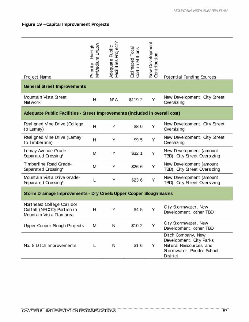
MOUNTAIN VISTA SUBAREA PLAN
CHAPTER 6 – IMPLEMENTATION RECOMMENDATIONS 57
Figure 19 – Capital Improvement Projects
Project Name Prio
rity
H
=Hig
h
M
=Med
ium
L=L
ow
Adeq
uate
Pub
lic
Faci
litie
s Pr
ojec
t?
Esti
mat
ed T
otal
Co
st in
Mill
ions
New
Dev
elop
men
t Co
ntri
buti
on
Potential Funding Sources
General Street Improvements
Mountain Vista Street Network H N/A $119.2 Y New Development, City Street
Oversizing
Adequate Public Facilities - Street Improvements (included in overall cost)
Realigned Vine Drive (College to Lemay) H Y $8.0 Y New Development, City Street
Oversizing
Realigned Vine Drive (Lemay to Timberline) H Y $9.5 Y New Development, City Street
Oversizing
Lemay Avenue Grade-Separated Crossing* M Y $32.1 Y New Development (amount
TBD), City Street Oversizing
Timberline Road Grade-Separated Crossing* M Y $26.6 Y New Development (amount
TBD), City Street Oversizing
Mountain Vista Drive Grade-Separated Crossing* L Y $23.6 Y New Development (amount
TBD), City Street Oversizing
Storm Drainage Improvements - Dry Creek/Upper Cooper Slough Basins
Northeast College Corridor Outfall (NECCO) Portion in Mountain Vista Plan area
H Y $4.5 Y City Stormwater, New Development, other TBD
Upper Cooper Slough Projects M N $10.2 Y City Stormwater, New Development, other TBD
No. 8 Ditch Improvements L N $1.6 Y
Ditch Company, New Development, City Parks, Natural Rescources, and Stormwater; Poudre School District
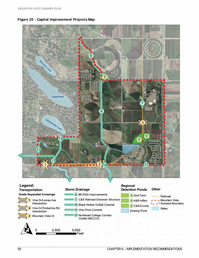
MOUNTAIN VISTA SUBAREA PLAN
58 CHAPTER 6 – IMPLEMENTATION RECOMMENDATIONS
Figure 20 - Capital Improvement Projects Map
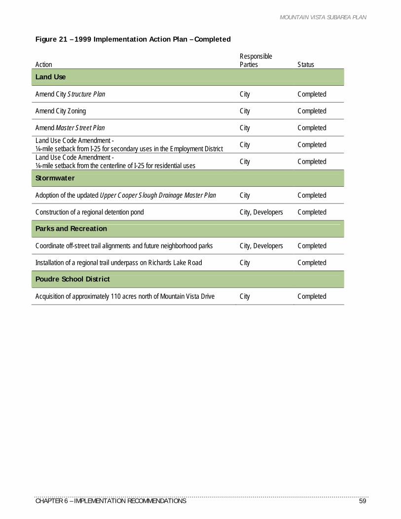
MOUNTAIN VISTA SUBAREA PLAN
CHAPTER 6 – IMPLEMENTATION RECOMMENDATIONS 59
Figure 21 – 1999 Implementation Action Plan – Completed Action
Responsible Parties Status
Land Use
Amend City Structure Plan City Completed
Amend City Zoning City Completed
Amend Master Street Plan City Completed
Land Use Code Amendment - ¼-mile setback from I-25 for secondary uses in the Employment District City Completed
Land Use Code Amendment - ¼-mile setback from the centerline of I-25 for residential uses City Completed
Stormwater
Adoption of the updated Upper Cooper Slough Drainage Master Plan City Completed
Construction of a regional detention pond City, Developers Completed
Parks and Recreation
Coordinate off-street trail alignments and future neighborhood parks City, Developers Completed
Installation of a regional trail underpass on Richards Lake Road City Completed
Poudre School District
Acquisition of approximately 110 acres north of Mountain Vista Drive City Completed
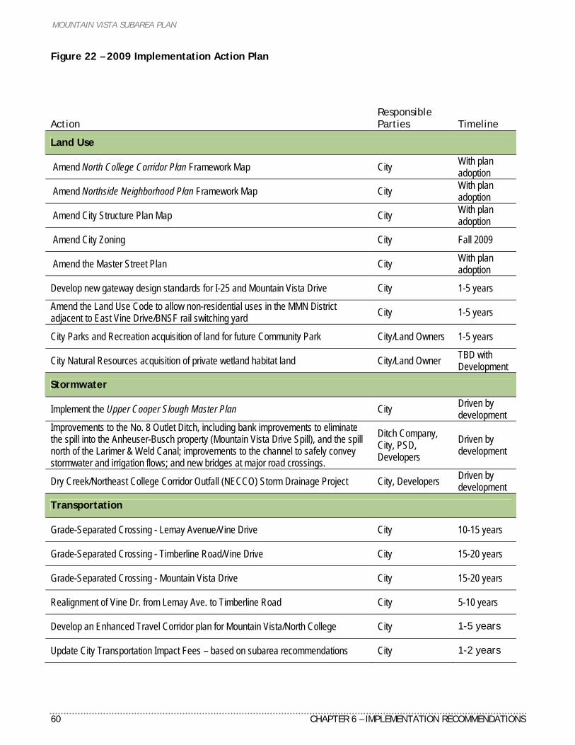
MOUNTAIN VISTA SUBAREA PLAN
60 CHAPTER 6 – IMPLEMENTATION RECOMMENDATIONS
Figure 22 – 2009 Implementation Action Plan
Action
Responsible Parties Timeline
Land Use
Amend North College Corridor Plan Framework Map City With plan adoption
Amend Northside Neighborhood Plan Framework Map City With plan adoption
Amend City Structure Plan Map City With plan adoption
Amend City Zoning City Fall 2009
Amend the Master Street Plan City With plan adoption
Develop new gateway design standards for I-25 and Mountain Vista Drive City 1-5 years
Amend the Land Use Code to allow non-residential uses in the MMN District adjacent to East Vine Drive/BNSF rail switching yard City 1-5 years
City Parks and Recreation acquisition of land for future Community Park City/Land Owners 1-5 years
City Natural Resources acquisition of private wetland habitat land City/Land Owner TBD with Development
Stormwater
Implement the Upper Cooper Slough Master Plan City Driven by development
Improvements to the No. 8 Outlet Ditch, including bank improvements to eliminate the spill into the Anheuser-Busch property (Mountain Vista Drive Spill), and the spill north of the Larimer & Weld Canal; improvements to the channel to safely convey stormwater and irrigation flows; and new bridges at major road crossings.
Ditch Company, City, PSD, Developers
Driven by development
Dry Creek/Northeast College Corridor Outfall (NECCO) Storm Drainage Project City, Developers Driven by development
Transportation
Grade-Separated Crossing - Lemay Avenue/Vine Drive City 10-15 years
Grade-Separated Crossing - Timberline Road/Vine Drive City 15-20 years
Grade-Separated Crossing - Mountain Vista Drive City 15-20 years
Realignment of Vine Dr. from Lemay Ave. to Timberline Road City 5-10 years
Develop an Enhanced Travel Corridor plan for Mountain Vista/North College City 1-5 years
Update City Transportation Impact Fees – based on subarea recommendations City 1-2 years
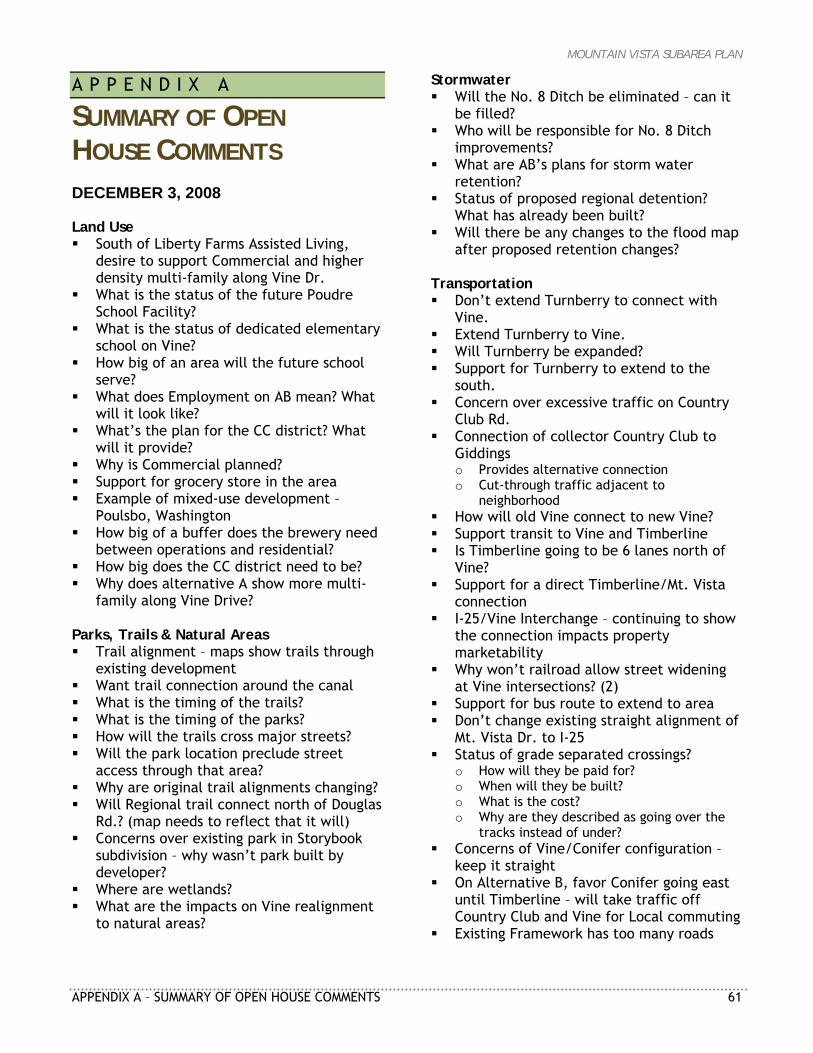
MOUNTAIN VISTA SUBAREA PLAN
APPENDIX A – SUMMARY OF OPEN HOUSE COMMENTS 61
A P P E N D I X A
SUMMARY OF OPEN HOUSE COMMENTS DECEMBER 3, 2008 Land Use South of Liberty Farms Assisted Living,
desire to support Commercial and higher density multi-family along Vine Dr.
What is the status of the future Poudre School Facility?
What is the status of dedicated elementary school on Vine?
How big of an area will the future school serve?
What does Employment on AB mean? What will it look like?
What’s the plan for the CC district? What will it provide?
Why is Commercial planned? Support for grocery store in the area Example of mixed-use development –
Poulsbo, Washington How big of a buffer does the brewery need
between operations and residential? How big does the CC district need to be? Why does alternative A show more multi-
family along Vine Drive? Parks, Trails & Natural Areas Trail alignment – maps show trails through
existing development Want trail connection around the canal What is the timing of the trails? What is the timing of the parks? How will the trails cross major streets? Will the park location preclude street
access through that area? Why are original trail alignments changing? Will Regional trail connect north of Douglas
Rd.? (map needs to reflect that it will) Concerns over existing park in Storybook
subdivision – why wasn’t park built by developer?
Where are wetlands? What are the impacts on Vine realignment
to natural areas?
Stormwater Will the No. 8 Ditch be eliminated – can it
be filled? Who will be responsible for No. 8 Ditch
improvements? What are AB’s plans for storm water
retention? Status of proposed regional detention?
What has already been built? Will there be any changes to the flood map
after proposed retention changes? Transportation Don’t extend Turnberry to connect with
Vine. Extend Turnberry to Vine. Will Turnberry be expanded? Support for Turnberry to extend to the
south. Concern over excessive traffic on Country
Club Rd. Connection of collector Country Club to
Giddings o Provides alternative connection o Cut-through traffic adjacent to
neighborhood How will old Vine connect to new Vine? Support transit to Vine and Timberline Is Timberline going to be 6 lanes north of
Vine? Support for a direct Timberline/Mt. Vista
connection I-25/Vine Interchange – continuing to show
the connection impacts property marketability
Why won’t railroad allow street widening at Vine intersections? (2)
Support for bus route to extend to area Don’t change existing straight alignment of
Mt. Vista Dr. to I-25 Status of grade separated crossings?
o How will they be paid for? o When will they be built? o What is the cost? o Why are they described as going over the
tracks instead of under? Concerns of Vine/Conifer configuration –
keep it straight On Alternative B, favor Conifer going east
until Timberline – will take traffic off Country Club and Vine for Local commuting
Existing Framework has too many roads
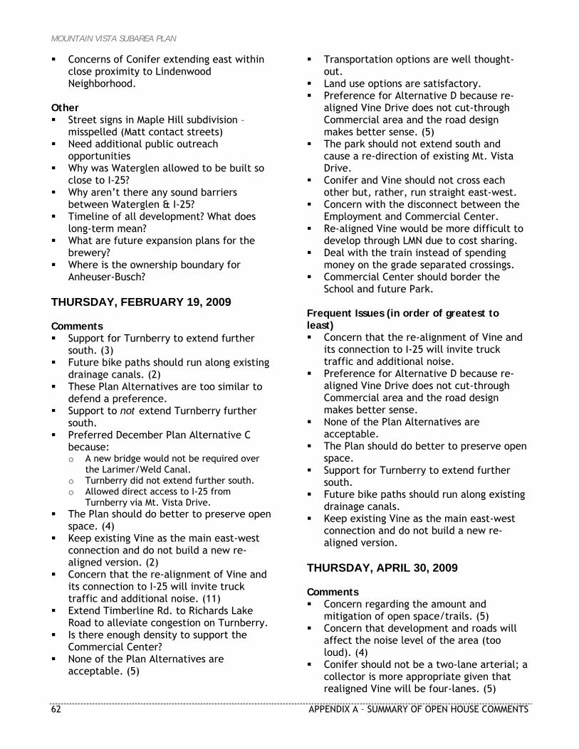
MOUNTAIN VISTA SUBAREA PLAN
62 APPENDIX A – SUMMARY OF OPEN HOUSE COMMENTS
Concerns of Conifer extending east within close proximity to Lindenwood Neighborhood.
Other Street signs in Maple Hill subdivision –
misspelled (Matt contact streets) Need additional public outreach
opportunities Why was Waterglen allowed to be built so
close to I-25? Why aren’t there any sound barriers
between Waterglen & I-25? Timeline of all development? What does
long-term mean? What are future expansion plans for the
brewery? Where is the ownership boundary for
Anheuser-Busch? THURSDAY, FEBRUARY 19, 2009 Comments Support for Turnberry to extend further
south. (3) Future bike paths should run along existing
drainage canals. (2) These Plan Alternatives are too similar to
defend a preference. Support to not extend Turnberry further
south. Preferred December Plan Alternative C
because: o A new bridge would not be required over
the Larimer/Weld Canal. o Turnberry did not extend further south. o Allowed direct access to I-25 from
Turnberry via Mt. Vista Drive. The Plan should do better to preserve open
space. (4) Keep existing Vine as the main east-west
connection and do not build a new re-aligned version. (2)
Concern that the re-alignment of Vine and its connection to I-25 will invite truck traffic and additional noise. (11)
Extend Timberline Rd. to Richards Lake Road to alleviate congestion on Turnberry.
Is there enough density to support the Commercial Center?
None of the Plan Alternatives are acceptable. (5)
Transportation options are well thought-out.
Land use options are satisfactory. Preference for Alternative D because re-
aligned Vine Drive does not cut-through Commercial area and the road design makes better sense. (5)
The park should not extend south and cause a re-direction of existing Mt. Vista Drive.
Conifer and Vine should not cross each other but, rather, run straight east-west.
Concern with the disconnect between the Employment and Commercial Center.
Re-aligned Vine would be more difficult to develop through LMN due to cost sharing.
Deal with the train instead of spending money on the grade separated crossings.
Commercial Center should border the School and future Park.
Frequent Issues (in order of greatest to least) Concern that the re-alignment of Vine and
its connection to I-25 will invite truck traffic and additional noise.
Preference for Alternative D because re-aligned Vine Drive does not cut-through Commercial area and the road design makes better sense.
None of the Plan Alternatives are acceptable.
The Plan should do better to preserve open space.
Support for Turnberry to extend further south.
Future bike paths should run along existing drainage canals.
Keep existing Vine as the main east-west connection and do not build a new re-aligned version.
THURSDAY, APRIL 30, 2009 Comments Concern regarding the amount and
mitigation of open space/trails. (5) Concern that development and roads will
affect the noise level of the area (too loud). (4)
Conifer should not be a two-lane arterial; a collector is more appropriate given that realigned Vine will be four-lanes. (5)
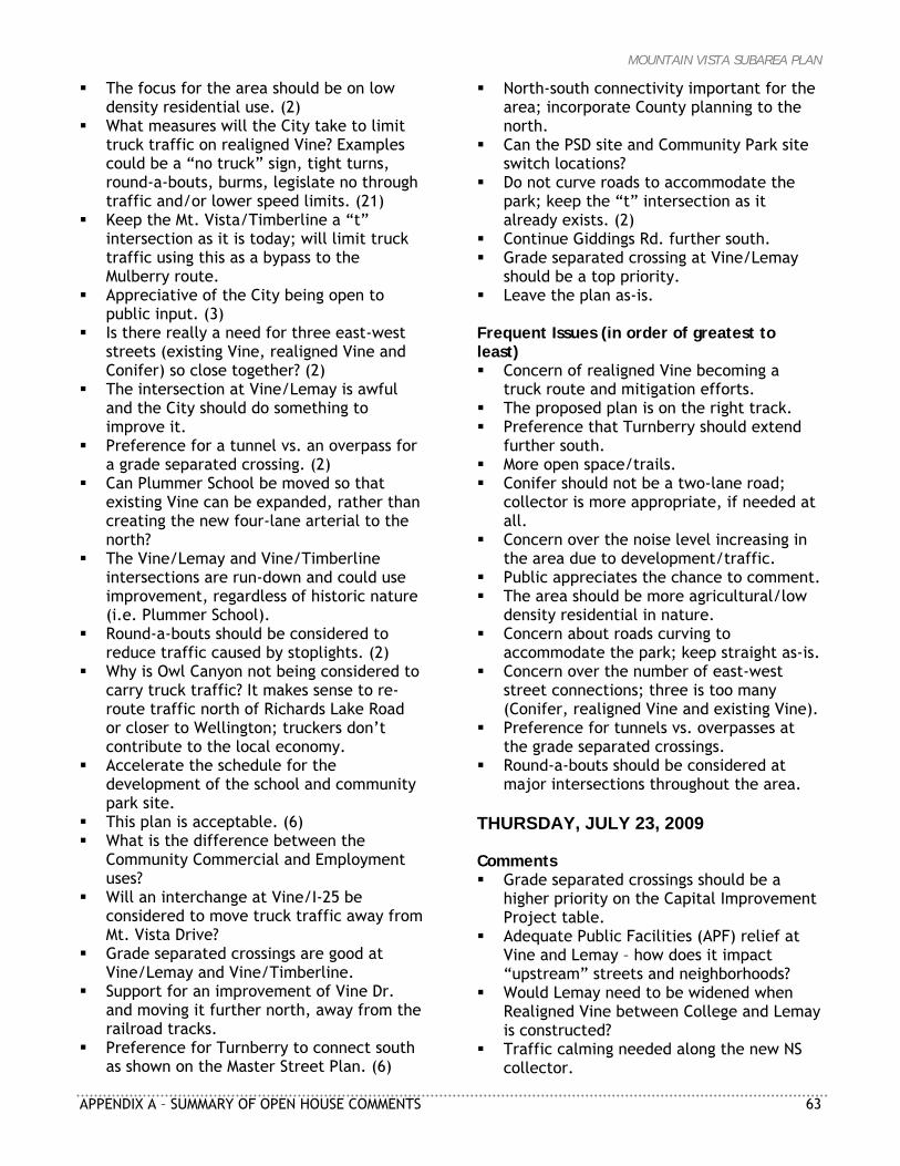
MOUNTAIN VISTA SUBAREA PLAN
APPENDIX A – SUMMARY OF OPEN HOUSE COMMENTS 63
The focus for the area should be on low density residential use. (2)
What measures will the City take to limit truck traffic on realigned Vine? Examples could be a “no truck” sign, tight turns, round-a-bouts, burms, legislate no through traffic and/or lower speed limits. (21)
Keep the Mt. Vista/Timberline a “t” intersection as it is today; will limit truck traffic using this as a bypass to the Mulberry route.
Appreciative of the City being open to public input. (3)
Is there really a need for three east-west streets (existing Vine, realigned Vine and Conifer) so close together? (2)
The intersection at Vine/Lemay is awful and the City should do something to improve it.
Preference for a tunnel vs. an overpass for a grade separated crossing. (2)
Can Plummer School be moved so that existing Vine can be expanded, rather than creating the new four-lane arterial to the north?
The Vine/Lemay and Vine/Timberline intersections are run-down and could use improvement, regardless of historic nature (i.e. Plummer School).
Round-a-bouts should be considered to reduce traffic caused by stoplights. (2)
Why is Owl Canyon not being considered to carry truck traffic? It makes sense to re-route traffic north of Richards Lake Road or closer to Wellington; truckers don’t contribute to the local economy.
Accelerate the schedule for the development of the school and community park site.
This plan is acceptable. (6) What is the difference between the
Community Commercial and Employment uses?
Will an interchange at Vine/I-25 be considered to move truck traffic away from Mt. Vista Drive?
Grade separated crossings are good at Vine/Lemay and Vine/Timberline.
Support for an improvement of Vine Dr. and moving it further north, away from the railroad tracks.
Preference for Turnberry to connect south as shown on the Master Street Plan. (6)
North-south connectivity important for the area; incorporate County planning to the north.
Can the PSD site and Community Park site switch locations?
Do not curve roads to accommodate the park; keep the “t” intersection as it already exists. (2)
Continue Giddings Rd. further south. Grade separated crossing at Vine/Lemay
should be a top priority. Leave the plan as-is.
Frequent Issues (in order of greatest to least) Concern of realigned Vine becoming a
truck route and mitigation efforts. The proposed plan is on the right track. Preference that Turnberry should extend
further south. More open space/trails. Conifer should not be a two-lane road;
collector is more appropriate, if needed at all.
Concern over the noise level increasing in the area due to development/traffic.
Public appreciates the chance to comment. The area should be more agricultural/low
density residential in nature. Concern about roads curving to
accommodate the park; keep straight as-is. Concern over the number of east-west
street connections; three is too many (Conifer, realigned Vine and existing Vine).
Preference for tunnels vs. overpasses at the grade separated crossings.
Round-a-bouts should be considered at major intersections throughout the area.
THURSDAY, JULY 23, 2009 Comments Grade separated crossings should be a
higher priority on the Capital Improvement Project table.
Adequate Public Facilities (APF) relief at Vine and Lemay – how does it impact “upstream” streets and neighborhoods?
Would Lemay need to be widened when Realigned Vine between College and Lemay is constructed?
Traffic calming needed along the new NS collector.
MOUNTAIN VISTA SUBAREA PLAN
64 APPENDIX A – SUMMARY OF OPEN HOUSE COMMENTS
Is the new Greeley water line (GWET) under the pavement of realigned Vine Drive?
Specify what the “T” in “ETC” could mean. It seems like there is a healthy mix of
Industry, Residential, Recreational, Natural, and Municipal in the planning.
I am not excited about (old) Vine being segmented, but I do see that it is currently inadequate or will become so soon and that there is little room for expansion as it is. Otherwise, I like the general plan.
Looks good – fewer streets, more defined grid.
Greatly prefer the Community Commercial District, Industrial and Employment from the 1999 plan – the current plan extends the district too far south and east. Too small of a buffer between Industrial and Residential.
Don’t want Conifer to be two-lane arterial – should be collector street (too many E-W corridors in small distance).
Still very concerned about re-aligned Vine becoming a de facto truck by-pass, and I-25/Vine interchange would virtually guarantee it. Adamantly opposed to such an interchange.
It would be better if all of the Community Park was north of Mountain Vista Dr.
It would be more professional if the projected costs of all the infrastructure changes were shown as a cost/acre for industrial and commercial development and a cost/unit for residential development. It would give the City an idea of how practical the plan is (or is not).
Despite the noise study, I am still concerned about the increase in traffic noise this plan would produce. It would have helped if the noise report would have showed the increase in noise to existing residential areas.
A realistic financing plan that supports construction of grade reparation must be formulated. The grade separation points are “choke points”/bottlenecks which otherwise threaten the viability of all the proposed arterials and future residential and commercial construction. Impact development fees are inadequate to meet the long term/future construction costs
because inflation will greatly out strip fund reserves from impact fees.
The “feasibility” of an I-25/Vine interchange must be removed from any consideration or citizens will reject the entire Mountain Vista Subarea Plan.
There is only so much land. You can always get more people. Small is beautiful.
Turnberry Rd. should extend south to realigned Vine Dr. (I)
Very well done. Info was clear. I hope it comes to pass!
The plans look absolutely great! When will development materialize?
The light rail system/bus rapid transit is absolutely necessary.
MOUNTAIN VISTA SUBAREA PLAN
APPENDIX B – LAND DEMAND ANALYSIS 59
A P P E N D I X B
MOUNTAIN VISTA SUBAREA PLAN LAND DEMAND ANALYSIS Prepared for: City of Fort Collins EDAW Prepared by: Economic & Planning Systems, Inc. June 24, 2009 EPS #18802
MOUNTAIN VISTA SUBAREA PLAN
60 APPENDIX B – LAND DEMAND ANALYSIS
Table of Contents Introduction ..............................................................63
Introduction ....................................................................63 Background .....................................................................64
Community Commercial Uses .........................................64 Existing Framework Plan .....................................................64 Historic and Projected Households .........................................65 Existing Retail Conditions ....................................................66 Retail Trade Area..............................................................68 Sales Potential/Retail Demand ..............................................70 Retail Development Potentials ..............................................72
Employment/Industrial Uses ..........................................76 Existing 1999 Plan Framework...............................................76 Historic and Projected Trends...............................................76 Employment/Industrial Demand ............................................77 Employment/Industrial Development Potentials .........................79 Employment/Industrial Development Capacity...........................80
Medium Density Mixed-Use Neighborhood .........................82 Historic Household Growth...................................................82 Apartment Market Conditions ...............................................83 Comparable Developments...................................................84 Multifamily Development Potentials........................................90
December 2008 - Plan Alternatives Analysis ......................91 Existing Framework ...........................................................92 Framework plan alternatives analysis ......................................93 Framework Plan—alternative A..............................................93 Framework Plan—Alternative B..............................................94 Framework Plan—Alternative C .............................................95
MOUNTAIN VISTA SUBAREA PLAN
APPENDIX B – LAND DEMAND ANALYSIS 61
List of Tables
Table B1 - Comparison of 1999 Plan to Preferred Framework .....................63
Table B2 - Mountain Vista Subarea Permits, 2000–2008.............................65
Table B3 - Projected Mountain Vista Households, 2008–2030 ......................66
Table B4 - Total Personal Income Growth, 2008–2030 ..............................70
Table B5 - Retail Expenditure Projection, 2008–2030 ...............................71
Table B6 - New Retail Demand by Square Feet, 2008–2030 ........................72
Table B7 - Mountain Vista Supportable Square Feet.................................74
Table B8 - Mountain Vista Subarea Development Program, 2015–2030...........75
Table B9 - Fort Collins Commercial Permits, 2000–2008 ............................77
Table B10 - Fort Collins Employment Projections....................................77
Table B11 - Fort Collins Employment Demand........................................78
Table B12 - Fort Collins Industrial Demand ...........................................78
Table B13 - Fort Collins Employment Land Demand .................................79
Table B14 - Fort Collins Industrial Land Demand.....................................79
Table B15 - Development Capacity.....................................................80
Table B16 - Mountain Vista Development Capacity ..................................81
Table B17 - Fort Collins Permits, 2000–2008 ..........................................82
Table B18 - Mountain Vista Permits, 2000–2008......................................83
Table B19 - Fort Collins Apartment Inventory, 2000–2008..........................84
Table B20 - Rock Creek Drive Developments .........................................86
Table B21 - Rigden Farm Developments ...............................................89
Table B22 - Multifamily Development Characteristics...............................90
Table B23 - Residential Land Demand Analysis .......................................91
Table B24 - Summary of Plan Alternative Land Use Acres ..........................92
MOUNTAIN VISTA SUBAREA PLAN
62 APPENDIX B – LAND DEMAND ANALYSIS
List of Figures
Figure B1 - Existing Retail Locations ...................................................67
Figure B2 - Grocery Store Trade Areas.................................................69
Figure B3 - Location of Comparable Multifamily Development ....................85
Figure B4 - Morningside Village Site Plan..............................................87
Figure B5 - Morningside Village Site Plan..............................................88
Figure B6 - Framework Plan—Alternative A ...........................................97
Figure B7 - Framework Plan—Alternative B ...........................................98
Figure B8 - Framework Plan—Alternative C ...........................................99
Figure B9 - Framework Plan—Alternative D ......................................... 100
Figure B10 - Framework Plan—Alternative E........................................ 101
Figure B11 - Framework Plan—Alternative F ........................................ 102
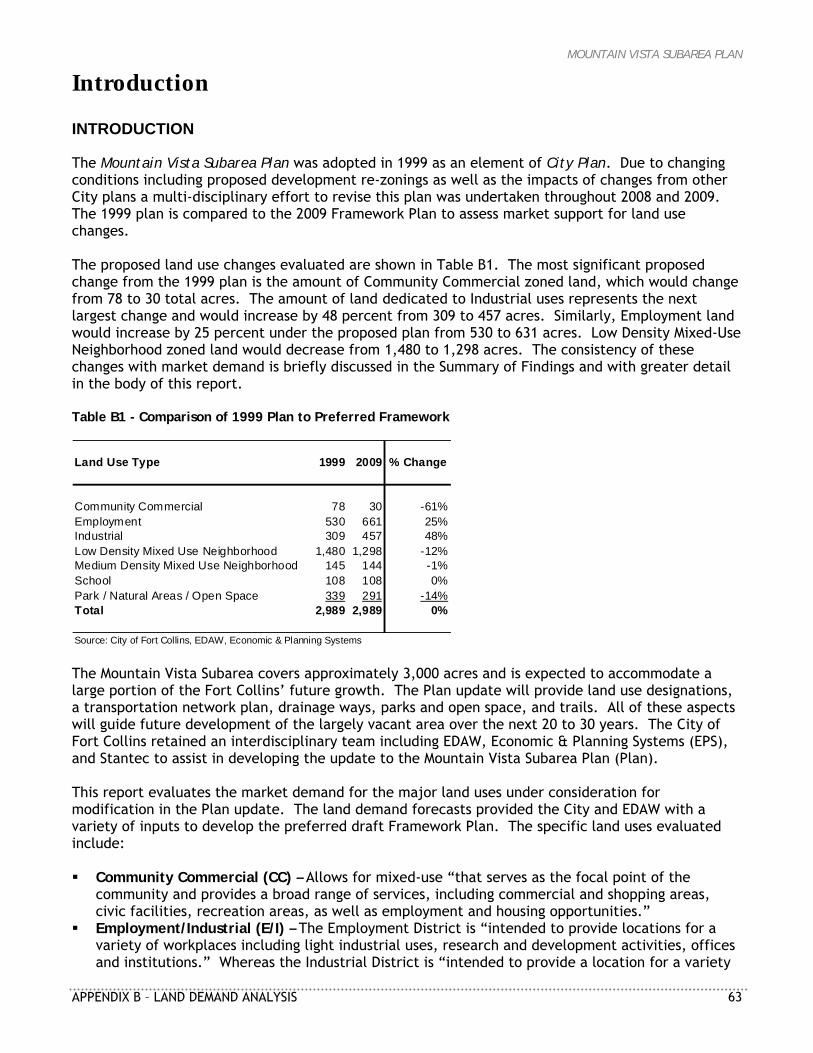
MOUNTAIN VISTA SUBAREA PLAN
APPENDIX B – LAND DEMAND ANALYSIS 63
Introduction INTRODUCTION The Mountain Vista Subarea Plan was adopted in 1999 as an element of City Plan. Due to changing conditions including proposed development re-zonings as well as the impacts of changes from other City plans a multi-disciplinary effort to revise this plan was undertaken throughout 2008 and 2009. The 1999 plan is compared to the 2009 Framework Plan to assess market support for land use changes. The proposed land use changes evaluated are shown in Table B1. The most significant proposed change from the 1999 plan is the amount of Community Commercial zoned land, which would change from 78 to 30 total acres. The amount of land dedicated to Industrial uses represents the next largest change and would increase by 48 percent from 309 to 457 acres. Similarly, Employment land would increase by 25 percent under the proposed plan from 530 to 631 acres. Low Density Mixed-Use Neighborhood zoned land would decrease from 1,480 to 1,298 acres. The consistency of these changes with market demand is briefly discussed in the Summary of Findings and with greater detail in the body of this report. Table B1 - Comparison of 1999 Plan to Preferred Framework
Land Use Type 1999 2009 % Change
Community Commercial 78 30 -61%Employment 530 661 25%Industrial 309 457 48%Low Density Mixed Use Neighborhood 1,480 1,298 -12%Medium Density Mixed Use Neighborhood 145 144 -1%School 108 108 0%Park / Natural Areas / Open Space 339 291 -14%Total 2,989 2,989 0%
Source: City of Fort Collins, EDAW, Economic & Planning Systems The Mountain Vista Subarea covers approximately 3,000 acres and is expected to accommodate a large portion of the Fort Collins’ future growth. The Plan update will provide land use designations, a transportation network plan, drainage ways, parks and open space, and trails. All of these aspects will guide future development of the largely vacant area over the next 20 to 30 years. The City of Fort Collins retained an interdisciplinary team including EDAW, Economic & Planning Systems (EPS), and Stantec to assist in developing the update to the Mountain Vista Subarea Plan (Plan). This report evaluates the market demand for the major land uses under consideration for modification in the Plan update. The land demand forecasts provided the City and EDAW with a variety of inputs to develop the preferred draft Framework Plan. The specific land uses evaluated include: Community Commercial (CC) – Allows for mixed-use “that serves as the focal point of the
community and provides a broad range of services, including commercial and shopping areas, civic facilities, recreation areas, as well as employment and housing opportunities.”
Employment/Industrial (E/I) – The Employment District is “intended to provide locations for a variety of workplaces including light industrial uses, research and development activities, offices and institutions.” Whereas the Industrial District is “intended to provide a location for a variety
MOUNTAIN VISTA SUBAREA PLAN
64 APPENDIX B – LAND DEMAND ANALYSIS
of work processes and work places such as manufacturing, warehousing and distributing, indoor and outdoor storage, and a wide range of commercial and industrial operations.”
Medium Density Mixed-Use Neighborhood (MMN) – The Medium Density Mixed-Use Neighborhood
District is “intended to be a place for attached and multifamily housing within easy walking distance of transit and” nearby shopping.
BACKGROUND The Plan update evaluates several aspects of the existing Plan framework and provide alternatives including the following: Assess options for land use/transportation elements, Locate a community park, Locate a community commercial district, Evaluate the realignment of Vine Drive, and Identify the opportunity for and location of an enhanced travel corridor.
The Plan update process developed six Framework Plank alternatives that include several consistent elements: (1) the land use designation for the Anheuser-Busch Industrial (ABI) property, (2) the location of the future Poudre School District facility and adjacent land use designation, (3) regional storm water detention facilities, (4) enhanced travel corridor (ETC) routes, (5) grade separated railroad crossings, and (6) bicycle and pedestrian off-street trails. However, each alternative provides several options for consideration: (1) the location of a 110-acre community park, (2) the location of a Town Center focal point for the Subarea Plan, (3) refinements to the Master Street Plan, (4) realignment of Vine Drive, (5) alignment of Conifer Street, and (6) the cost for major street infrastructure. The report evaluates the market demand for the land uses as described and utilizes the outcome of the land demand forecasts, which provided a basis to guide the development of the proposed 2009 Framework Plan. The final chapter of the report provides greater detail regarding the marketability of each of the plans and feedback concerning the land use and transportation choices represented by each of the alternatives.
Community Commercial Uses The original Mountain Vista Subarea Plan was completed in 1999. The plan includes a significant Community Commercial (CC) zone district located in the center of the subarea and envisions this as a mixed-use focal point for the subarea. This section of the report summarizes the retail land demand analysis. EXISTING FRAMEWORK PLAN The CC District is identified in the proposed 2009 Framework Plan as a place “that serves as the focal point of the community and provides a broad range of services, including commercial and shopping areas, civic facilities, recreation areas, as well as employment and housing opportunities.” The mixed-use area is intended to encompass a broad range of uses, including multi-story buildings with street front stores in a downtown-like environment. The Plan specifically identifies the need for both a grocery store/supermarket to serve the surrounding population and a 10- to 15-acre Neighborhood Commercial District to be embedded within the larger CC district as a whole. The approximately 80 acres included in the 1999 Plan
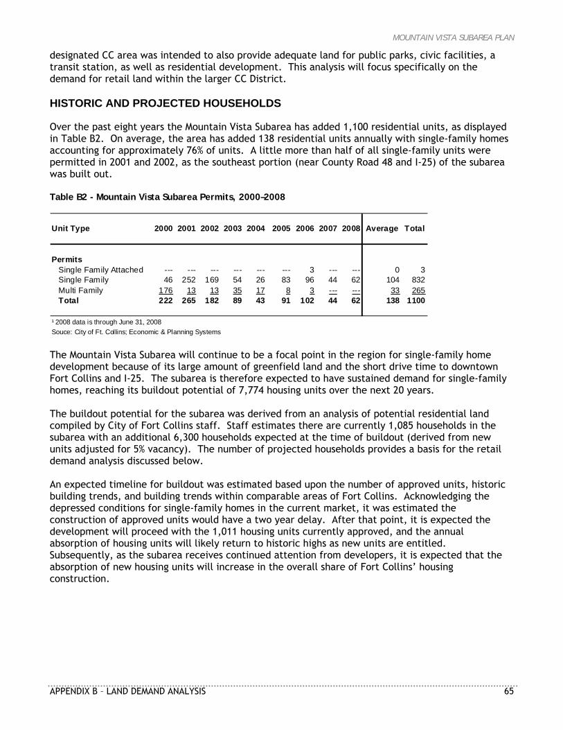
MOUNTAIN VISTA SUBAREA PLAN
APPENDIX B – LAND DEMAND ANALYSIS 65
designated CC area was intended to also provide adequate land for public parks, civic facilities, a transit station, as well as residential development. This analysis will focus specifically on the demand for retail land within the larger CC District. HISTORIC AND PROJECTED HOUSEHOLDS Over the past eight years the Mountain Vista Subarea has added 1,100 residential units, as displayed in Table B2. On average, the area has added 138 residential units annually with single-family homes accounting for approximately 76% of units. A little more than half of all single-family units were permitted in 2001 and 2002, as the southeast portion (near County Road 48 and I-25) of the subarea was built out. Table B2 - Mountain Vista Subarea Permits, 2000–2008
Unit Type 2000 2001 2002 2003 2004 2005 2006 2007 2008 Average Total
PermitsSingle Family Attached --- --- --- --- --- --- 3 --- --- 0 3Single Family 46 252 169 54 26 83 96 44 62 104 832Multi Family 176 13 13 35 17 8 3 --- --- 33 265Total 222 265 182 89 43 91 102 44 62 138 1100
¹ 2008 data is through June 31, 2008Souce: City of Ft. Collins; Economic & Planning Systems The Mountain Vista Subarea will continue to be a focal point in the region for single-family home development because of its large amount of greenfield land and the short drive time to downtown Fort Collins and I-25. The subarea is therefore expected to have sustained demand for single-family homes, reaching its buildout potential of 7,774 housing units over the next 20 years. The buildout potential for the subarea was derived from an analysis of potential residential land compiled by City of Fort Collins staff. Staff estimates there are currently 1,085 households in the subarea with an additional 6,300 households expected at the time of buildout (derived from new units adjusted for 5% vacancy). The number of projected households provides a basis for the retail demand analysis discussed below. An expected timeline for buildout was estimated based upon the number of approved units, historic building trends, and building trends within comparable areas of Fort Collins. Acknowledging the depressed conditions for single-family homes in the current market, it was estimated the construction of approved units would have a two year delay. After that point, it is expected the development will proceed with the 1,011 housing units currently approved, and the annual absorption of housing units will likely return to historic highs as new units are entitled. Subsequently, as the subarea receives continued attention from developers, it is expected that the absorption of new housing units will increase in the overall share of Fort Collins’ housing construction.
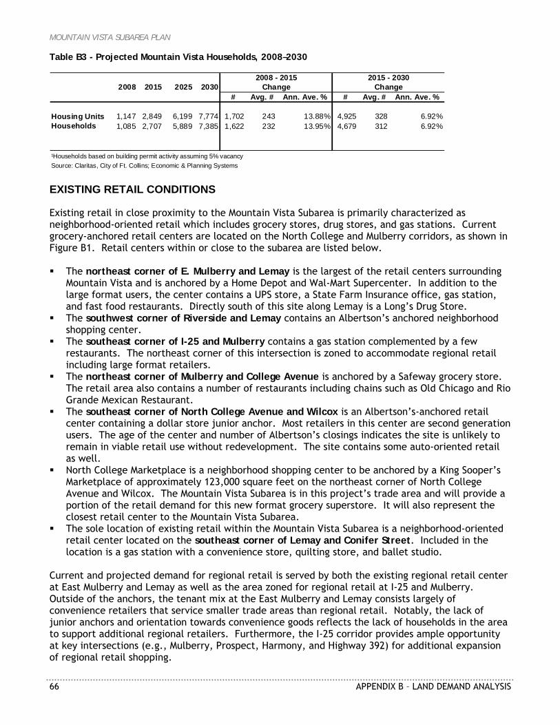
MOUNTAIN VISTA SUBAREA PLAN
66 APPENDIX B – LAND DEMAND ANALYSIS
Table B3 - Projected Mountain Vista Households, 2008–2030
2008 2015 2025 2030# Avg. # Ann. Ave. % # Avg. # Ann. Ave. %
Housing Units 1,147 2,849 6,199 7,774 1,702 243 13.88% 4,925 328 6.92%Households 1,085 2,707 5,889 7,385 1,622 232 13.95% 4,679 312 6.92%
¹Households based on building permit activity assuming 5% vacancySource: Claritas, City of Ft. Collins; Economic & Planning Systems
2015 - 2030Change
2008 - 2015Change
EXISTING RETAIL CONDITIONS Existing retail in close proximity to the Mountain Vista Subarea is primarily characterized as neighborhood-oriented retail which includes grocery stores, drug stores, and gas stations. Current grocery-anchored retail centers are located on the North College and Mulberry corridors, as shown in Figure B1. Retail centers within or close to the subarea are listed below. The northeast corner of E. Mulberry and Lemay is the largest of the retail centers surrounding
Mountain Vista and is anchored by a Home Depot and Wal-Mart Supercenter. In addition to the large format users, the center contains a UPS store, a State Farm Insurance office, gas station, and fast food restaurants. Directly south of this site along Lemay is a Long’s Drug Store.
The southwest corner of Riverside and Lemay contains an Albertson’s anchored neighborhood shopping center.
The southeast corner of I-25 and Mulberry contains a gas station complemented by a few restaurants. The northeast corner of this intersection is zoned to accommodate regional retail including large format retailers.
The northeast corner of Mulberry and College Avenue is anchored by a Safeway grocery store. The retail area also contains a number of restaurants including chains such as Old Chicago and Rio Grande Mexican Restaurant.
The southeast corner of North College Avenue and Wilcox is an Albertson’s-anchored retail center containing a dollar store junior anchor. Most retailers in this center are second generation users. The age of the center and number of Albertson’s closings indicates the site is unlikely to remain in viable retail use without redevelopment. The site contains some auto-oriented retail as well.
North College Marketplace is a neighborhood shopping center to be anchored by a King Sooper’s Marketplace of approximately 123,000 square feet on the northeast corner of North College Avenue and Wilcox. The Mountain Vista Subarea is in this project’s trade area and will provide a portion of the retail demand for this new format grocery superstore. It will also represent the closest retail center to the Mountain Vista Subarea.
The sole location of existing retail within the Mountain Vista Subarea is a neighborhood-oriented retail center located on the southeast corner of Lemay and Conifer Street. Included in the location is a gas station with a convenience store, quilting store, and ballet studio.
Current and projected demand for regional retail is served by both the existing regional retail center at East Mulberry and Lemay as well as the area zoned for regional retail at I-25 and Mulberry. Outside of the anchors, the tenant mix at the East Mulberry and Lemay consists largely of convenience retailers that service smaller trade areas than regional retail. Notably, the lack of junior anchors and orientation towards convenience goods reflects the lack of households in the area to support additional regional retailers. Furthermore, the I-25 corridor provides ample opportunity at key intersections (e.g., Mulberry, Prospect, Harmony, and Highway 392) for additional expansion of regional retail shopping.
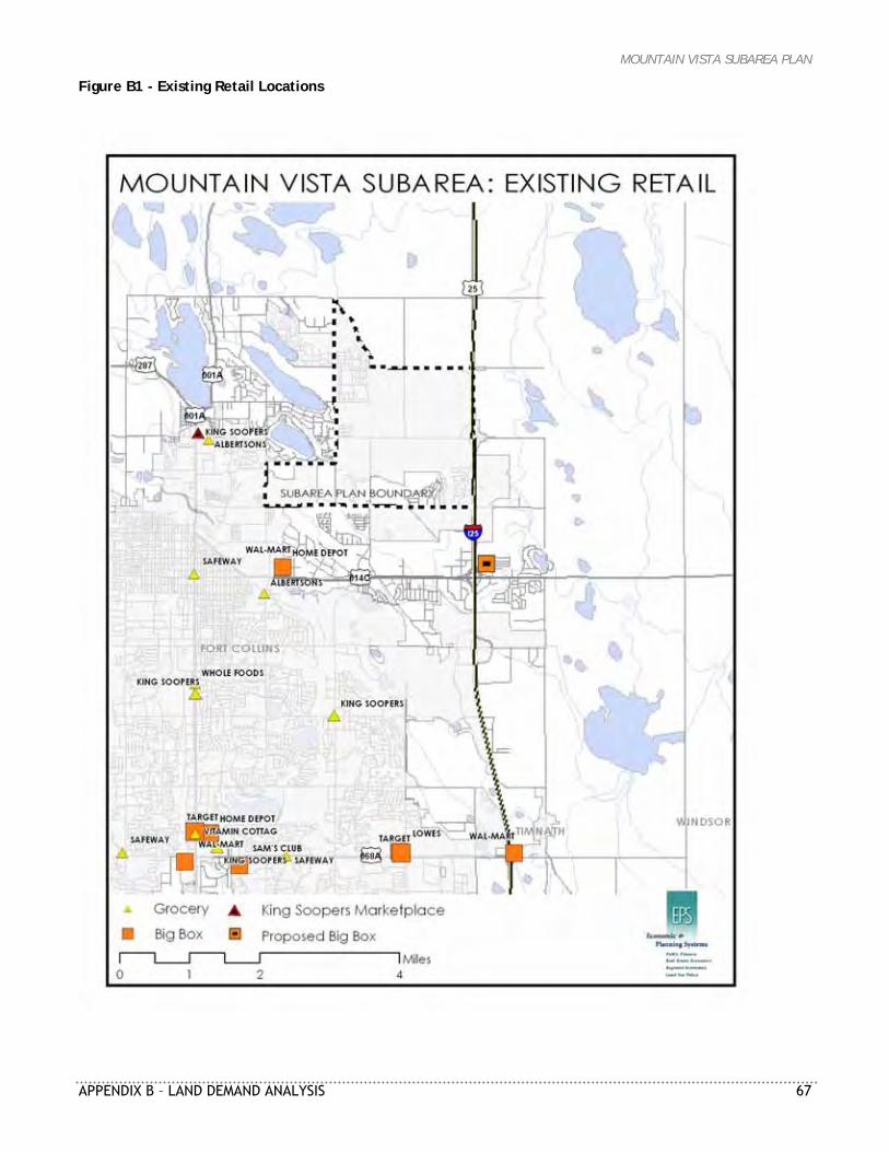
MOUNTAIN VISTA SUBAREA PLAN
APPENDIX B – LAND DEMAND ANALYSIS 67
Figure B1 - Existing Retail Locations
MOUNTAIN VISTA SUBAREA PLAN
68 APPENDIX B – LAND DEMAND ANALYSIS
The primary retail opportunities for the Mountain Vista Subarea will be linked to residential development. The retail opportunities will therefore have a neighborhood orientation and likely include grocery stores, drug stores, restaurants, and a small selection of independent retailers offering a variety of goods and services (e.g., flowers, salons, dry cleaning, and restaurants). The next section examines the expenditure potential for the Mountain Vista Subarea and resulting support for neighborhood-oriented retail stores. RETAIL TRADE AREA The trade area used to estimate future retail demand within the Mountain Vista Subarea was discerned by analyzing the trade areas of existing, planned, and future nearby grocery stores, as displayed in Figure B2. A neighborhood shopping center is the primary retail format anticipated for the Mountain Vista Subarea. These centers are typically built around a supermarket as the anchor store. As a result, grocery stores were used as a proxy for determining the location of neighborhood shopping centers. Analysis of the trade areas indicates that the existing grocery trade areas cover most of the existing residential development in the subarea but do not cover portions of Mountain Vista planned for future residential development. As a result, the future residential development within the Mountain Vista Subarea can reasonably be assumed to indicate the locations and amount of future retail demand for the subarea. The spending in these households on retail represents an unmet segment of the current market. Dependant on timing, the planned and zoned grocery store site on East Mulberry Street could respond to a portion of new retail demand within the subarea.
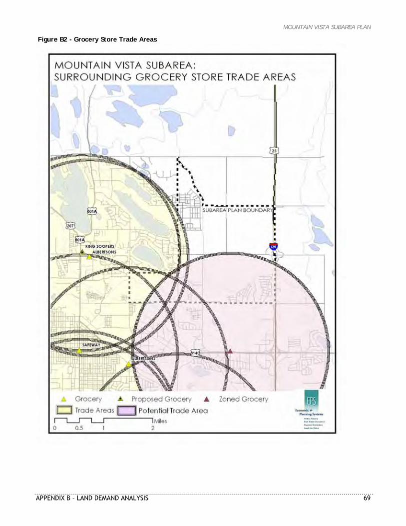
MOUNTAIN VISTA SUBAREA PLAN
APPENDIX B – LAND DEMAND ANALYSIS 69
Figure B2 - Grocery Store Trade Areas
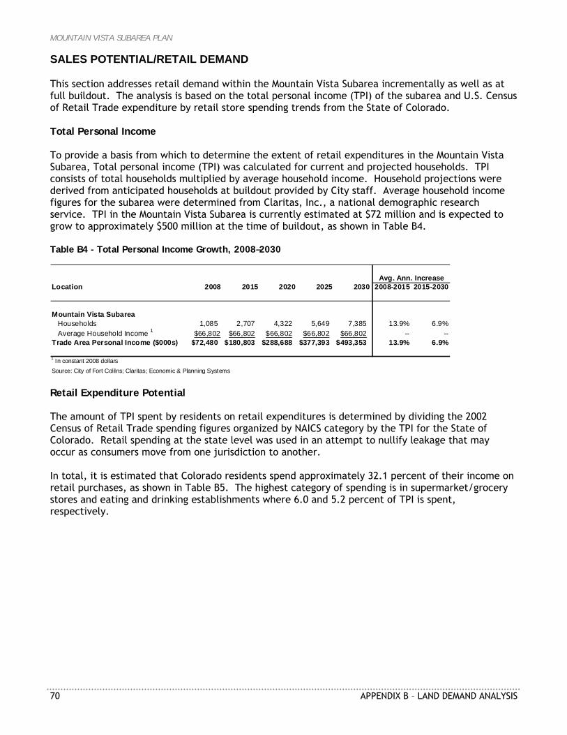
MOUNTAIN VISTA SUBAREA PLAN
70 APPENDIX B – LAND DEMAND ANALYSIS
SALES POTENTIAL/RETAIL DEMAND This section addresses retail demand within the Mountain Vista Subarea incrementally as well as at full buildout. The analysis is based on the total personal income (TPI) of the subarea and U.S. Census of Retail Trade expenditure by retail store spending trends from the State of Colorado. Total Personal Income To provide a basis from which to determine the extent of retail expenditures in the Mountain Vista Subarea, Total personal income (TPI) was calculated for current and projected households. TPI consists of total households multiplied by average household income. Household projections were derived from anticipated households at buildout provided by City staff. Average household income figures for the subarea were determined from Claritas, Inc., a national demographic research service. TPI in the Mountain Vista Subarea is currently estimated at $72 million and is expected to grow to approximately $500 million at the time of buildout, as shown in Table B4. Table B4 - Total Personal Income Growth, 2008–2030
Location 2008 2015 2020 2025 2030 2008-2015 2015-2030
Mountain Vista SubareaHouseholds 1,085 2,707 4,322 5,649 7,385 13.9% 6.9%Average Household Income 1 $66,802 $66,802 $66,802 $66,802 $66,802 -- --
Trade Area Personal Income ($000s) $72,480 $180,803 $288,688 $377,393 $493,353 13.9% 6.9%
1 In constant 2008 dollarsSource: City of Fort Colilns; Claritas; Economic & Planning Systems
Avg. Ann. Increase
Retail Expenditure Potential The amount of TPI spent by residents on retail expenditures is determined by dividing the 2002 Census of Retail Trade spending figures organized by NAICS category by the TPI for the State of Colorado. Retail spending at the state level was used in an attempt to nullify leakage that may occur as consumers move from one jurisdiction to another. In total, it is estimated that Colorado residents spend approximately 32.1 percent of their income on retail purchases, as shown in Table B5. The highest category of spending is in supermarket/grocery stores and eating and drinking establishments where 6.0 and 5.2 percent of TPI is spent, respectively.
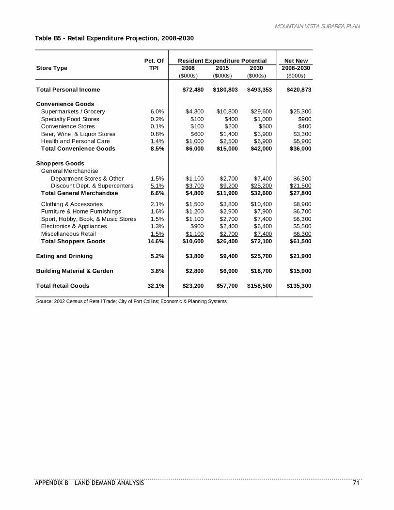
MOUNTAIN VISTA SUBAREA PLAN
APPENDIX B – LAND DEMAND ANALYSIS 71
Table B5 - Retail Expenditure Projection, 2008–2030
Pct. OfStore Type TPI 2008 2015 2030 2008-2030
($000s) ($000s) ($000s) ($000s)
Total Personal Income $72,480 $180,803 $493,353 $420,873
Convenience GoodsSupermarkets / Grocery 6.0% $4,300 $10,800 $29,600 $25,300Specialty Food Stores 0.2% $100 $400 $1,000 $900Convenience Stores 0.1% $100 $200 $500 $400Beer, Wine, & Liquor Stores 0.8% $600 $1,400 $3,900 $3,300Health and Personal Care 1.4% $1,000 $2,500 $6,900 $5,900Total Convenience Goods 8.5% $6,000 $15,000 $42,000 $36,000
Shoppers GoodsGeneral Merchandise
Department Stores & Other 1.5% $1,100 $2,700 $7,400 $6,300Discount Dept. & Supercenters 5.1% $3,700 $9,200 $25,200 $21,500
Total General Merchandise 6.6% $4,800 $11,900 $32,600 $27,800
Clothing & Accessories 2.1% $1,500 $3,800 $10,400 $8,900Furniture & Home Furnishings 1.6% $1,200 $2,900 $7,900 $6,700Sport, Hobby, Book, & Music Stores 1.5% $1,100 $2,700 $7,400 $6,300Electronics & Appliances 1.3% $900 $2,400 $6,400 $5,500Miscellaneous Retail 1.5% $1,100 $2,700 $7,400 $6,300Total Shoppers Goods 14.6% $10,600 $26,400 $72,100 $61,500
Eating and Drinking 5.2% $3,800 $9,400 $25,700 $21,900
Building Material & Garden 3.8% $2,800 $6,900 $18,700 $15,900
Total Retail Goods 32.1% $23,200 $57,700 $158,500 $135,300
Source: 2002 Census of Retail Trade; City of Fort Collins; Economic & Planning Systems
Resident Expenditure Potential Net New
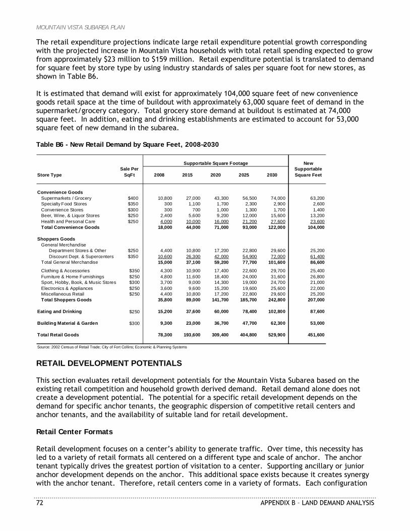
MOUNTAIN VISTA SUBAREA PLAN
72 APPENDIX B – LAND DEMAND ANALYSIS
The retail expenditure projections indicate large retail expenditure potential growth corresponding with the projected increase in Mountain Vista households with total retail spending expected to grow from approximately $23 million to $159 million. Retail expenditure potential is translated to demand for square feet by store type by using industry standards of sales per square foot for new stores, as shown in Table B6. It is estimated that demand will exist for approximately 104,000 square feet of new convenience goods retail space at the time of buildout with approximately 63,000 square feet of demand in the supermarket/grocery category. Total grocery store demand at buildout is estimated at 74,000 square feet. In addition, eating and drinking establishments are estimated to account for 53,000 square feet of new demand in the subarea. Table B6 - New Retail Demand by Square Feet, 2008–2030
New
Store TypeSale Per
SqFt 2008 2015 2020 2025 2030Supportable Square Feet
Convenience GoodsSupermarkets / Grocery $400 10,800 27,000 43,300 56,500 74,000 63,200Specialty Food Stores $350 300 1,100 1,700 2,300 2,900 2,600Convenience Stores $300 300 700 1,000 1,300 1,700 1,400Beer, Wine, & Liquor Stores $250 2,400 5,600 9,200 12,000 15,600 13,200Health and Personal Care $250 4,000 10,000 16,000 21,200 27,600 23,600Total Convenience Goods 18,000 44,000 71,000 93,000 122,000 104,000
Shoppers GoodsGeneral Merchandise
Department Stores & Other $250 4,400 10,800 17,200 22,800 29,600 25,200Discount Dept. & Supercenters $350 10,600 26,300 42,000 54,900 72,000 61,400
Total General Merchandise 15,000 37,100 59,200 77,700 101,600 86,600
Clothing & Accessories $350 4,300 10,900 17,400 22,600 29,700 25,400Furniture & Home Furnishings $250 4,800 11,600 18,400 24,000 31,600 26,800Sport, Hobby, Book, & Music Stores $300 3,700 9,000 14,300 19,000 24,700 21,000Electronics & Appliances $250 3,600 9,600 15,200 19,600 25,600 22,000Miscellaneous Retail $250 4,400 10,800 17,200 22,800 29,600 25,200Total Shoppers Goods 35,800 89,000 141,700 185,700 242,800 207,000
Eating and Drinking $250 15,200 37,600 60,000 78,400 102,800 87,600
Building Material & Garden $300 9,300 23,000 36,700 47,700 62,300 53,000
Total Retail Goods 78,300 193,600 309,400 404,800 529,900 451,600
Source: 2002 Census of Retail Trade; City of Fort Collins; Economic & Planning Systems
Supportable Square Footage
RETAIL DEVELOPMENT POTENTIALS This section evaluates retail development potentials for the Mountain Vista Subarea based on the existing retail competition and household growth derived demand. Retail demand alone does not create a development potential. The potential for a specific retail development depends on the demand for specific anchor tenants, the geographic dispersion of competitive retail centers and anchor tenants, and the availability of suitable land for retail development. Retail Center Formats Retail development focuses on a center’s ability to generate traffic. Over time, this necessity has led to a variety of retail formats all centered on a different type and scale of anchor. The anchor tenant typically drives the greatest portion of visitation to a center. Supporting ancillary or junior anchor development depends on the anchor. This additional space exists because it creates synergy with the anchor tenant. Therefore, retail centers come in a variety of formats. Each configuration
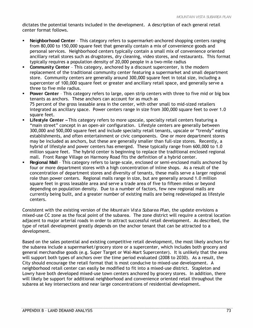
MOUNTAIN VISTA SUBAREA PLAN
APPENDIX B – LAND DEMAND ANALYSIS 73
dictates the potential tenants included in the development. A description of each general retail center format follows. Neighborhood Center – This category refers to supermarket-anchored shopping centers ranging
from 80,000 to 150,000 square feet that generally contain a mix of convenience goods and personal services. Neighborhood centers typically contain a small mix of convenience oriented ancillary retail stores such as drugstores, dry cleaning, video stores, and restaurants. This format typically requires a population density of 20,000 people in a two-mile radius
Community Center – This category, anchored by a discount supercenter, is the modern replacement of the traditional community center featuring a supermarket and small department store. Community centers are generally around 300,000 square feet in total size, including a supercenter of 100,000 square feet or greater and ancillary retail space, and generally serve a three to five mile radius.
Power Center – This category refers to large, open strip centers with three to five mid or big box tenants as anchors. These anchors can account for as much as 75 percent of the gross leasable area in the center, with other small to mid-sized retailers integrated as ancillary space. Power centers range in size from 300,000 square feet to over 1.0 square feet.
Lifestyle Center – This category refers to more upscale, specialty retail centers featuring a “main street” concept in an open-air configuration. Lifestyle centers are generally between 300,000 and 500,000 square feet and include specialty retail tenants, upscale or “trendy” eating establishments, and often entertainment or civic components. One or more department stores may be included as anchors, but these are generally smaller than full-size stores. Recently, a hybrid of lifestyle and power centers has emerged. These typically range from 600,000 to 1.0 million square feet. The hybrid center is beginning to replace the traditional enclosed regional mall. Front Range Village on Harmony Road fits the definition of a hybrid center.
Regional Mall – This category refers to large-scale, enclosed or semi-enclosed malls anchored by four or more department stores with a high concentration of inline shops. As a result of the concentration of department stores and diversity of tenants, these malls serve a larger regional role than power centers. Regional malls range in size, but are generally around 1.0 million square feet in gross leasable area and serve a trade area of five to fifteen miles or beyond depending on population density. Due to a number of factors, few new regional malls are currently being built, and a greater number of existing malls are being redeveloped as lifestyle centers.
Consistent with the existing version of the Mountain Vista Subarea Plan, the update envisions a mixed-use CC zone as the focal point of the subarea. The zone district will require a central location adjacent to major arterial roads in order to attract successful retail development. As described, the type of retail development greatly depends on the anchor tenant that can be attracted to a development. Based on the sales potential and existing competitive retail development, the most likely anchors for the subarea include a supermarket/grocery store or a supercenter, which includes both grocery and general merchandise goods (e.g. Super Target or Wal-Mart Supercenter). It is unlikely that the area will support both types of anchors over the time period evaluated (2008 to 2030). As a result, the City should encourage the retail format that is most conducive to mixed-use development. A neighborhood retail center can easily be modified to fit into a mixed-use district. Stapleton and Lowry have both developed mixed-use town centers anchored by grocery stores. In addition, there will likely be support for additional neighborhood and convenience oriented retail throughout the subarea at key intersections and near large concentrations of residential development.
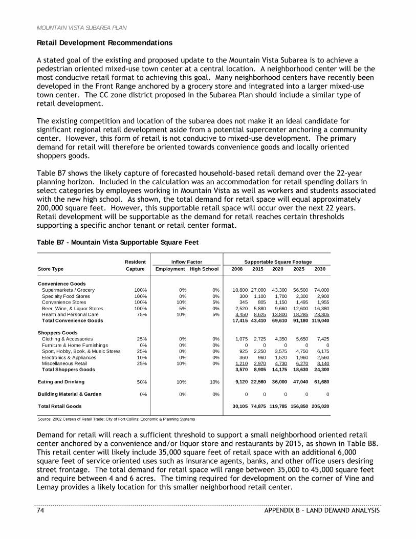
MOUNTAIN VISTA SUBAREA PLAN
74 APPENDIX B – LAND DEMAND ANALYSIS
Retail Development Recommendations A stated goal of the existing and proposed update to the Mountain Vista Subarea is to achieve a pedestrian oriented mixed-use town center at a central location. A neighborhood center will be the most conducive retail format to achieving this goal. Many neighborhood centers have recently been developed in the Front Range anchored by a grocery store and integrated into a larger mixed-use town center. The CC zone district proposed in the Subarea Plan should include a similar type of retail development. The existing competition and location of the subarea does not make it an ideal candidate for significant regional retail development aside from a potential supercenter anchoring a community center. However, this form of retail is not conducive to mixed-use development. The primary demand for retail will therefore be oriented towards convenience goods and locally oriented shoppers goods. Table B7 shows the likely capture of forecasted household-based retail demand over the 22-year planning horizon. Included in the calculation was an accommodation for retail spending dollars in select categories by employees working in Mountain Vista as well as workers and students associated with the new high school. As shown, the total demand for retail space will equal approximately 200,000 square feet. However, this supportable retail space will occur over the next 22 years. Retail development will be supportable as the demand for retail reaches certain thresholds supporting a specific anchor tenant or retail center format. Table B7 - Mountain Vista Supportable Square Feet
ResidentStore Type Capture Employment High School 2008 2015 2020 2025 2030
Convenience GoodsSupermarkets / Grocery 100% 0% 0% 10,800 27,000 43,300 56,500 74,000Specialty Food Stores 100% 0% 0% 300 1,100 1,700 2,300 2,900Convenience Stores 100% 10% 5% 345 805 1,150 1,495 1,955Beer, Wine, & Liquor Stores 100% 5% 0% 2,520 5,880 9,660 12,600 16,380Health and Personal Care 75% 10% 5% 3,450 8,625 13,800 18,285 23,805Total Convenience Goods 17,415 43,410 69,610 91,180 119,040
Shoppers GoodsClothing & Accessories 25% 0% 0% 1,075 2,725 4,350 5,650 7,425Furniture & Home Furnishings 0% 0% 0% 0 0 0 0 0Sport, Hobby, Book, & Music Stores 25% 0% 0% 925 2,250 3,575 4,750 6,175Electronics & Appliances 10% 0% 0% 360 960 1,520 1,960 2,560Miscellaneous Retail 25% 10% 0% 1,210 2,970 4,730 6,270 8,140Total Shoppers Goods 3,570 8,905 14,175 18,630 24,300
Eating and Drinking 50% 10% 10% 9,120 22,560 36,000 47,040 61,680
Building Material & Garden 0% 0% 0% 0 0 0 0 0
Total Retail Goods 30,105 74,875 119,785 156,850 205,020
Source: 2002 Census of Retail Trade; City of Fort Collins; Economic & Planning Systems
Supportable Square FootageInflow Factor
Demand for retail will reach a sufficient threshold to support a small neighborhood oriented retail center anchored by a convenience and/or liquor store and restaurants by 2015, as shown in Table B8. This retail center will likely include 35,000 square feet of retail space with an additional 6,000 square feet of service oriented uses such as insurance agents, banks, and other office users desiring street frontage. The total demand for retail space will range between 35,000 to 45,000 square feet and require between 4 and 6 acres. The timing required for development on the corner of Vine and Lemay provides a likely location for this smaller neighborhood retail center.
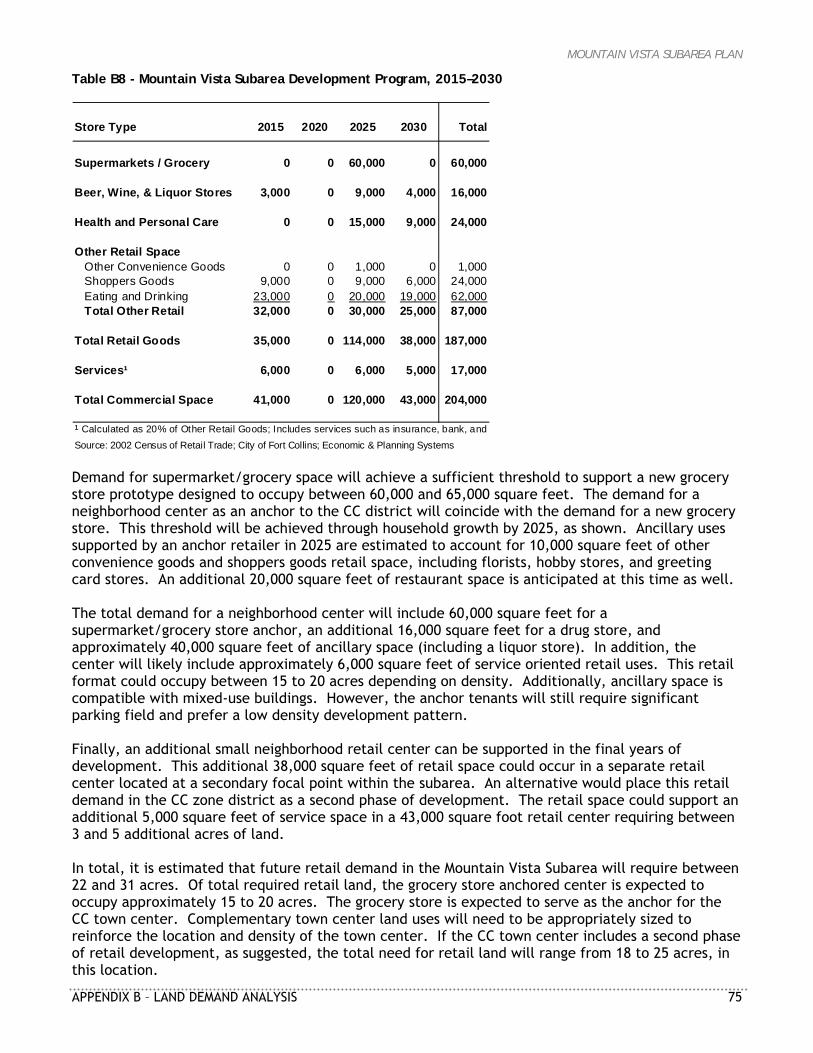
MOUNTAIN VISTA SUBAREA PLAN
APPENDIX B – LAND DEMAND ANALYSIS 75
Table B8 - Mountain Vista Subarea Development Program, 2015–2030
Store Type 2015 2020 2025 2030 Total
Supermarkets / Grocery 0 0 60,000 0 60,000
Beer, Wine, & Liquor Stores 3,000 0 9,000 4,000 16,000
Health and Personal Care 0 0 15,000 9,000 24,000
Other Retail SpaceOther Convenience Goods 0 0 1,000 0 1,000Shoppers Goods 9,000 0 9,000 6,000 24,000Eating and Drinking 23,000 0 20,000 19,000 62,000Total Other Retail 32,000 0 30,000 25,000 87,000
Total Retail Goods 35,000 0 114,000 38,000 187,000
Services¹ 6,000 0 6,000 5,000 17,000
Total Commercial Space 41,000 0 120,000 43,000 204,000
¹ Calculated as 20% of Other Retail Goods; Includes services such as insurance, bank, and rSource: 2002 Census of Retail Trade; City of Fort Collins; Economic & Planning Systems Demand for supermarket/grocery space will achieve a sufficient threshold to support a new grocery store prototype designed to occupy between 60,000 and 65,000 square feet. The demand for a neighborhood center as an anchor to the CC district will coincide with the demand for a new grocery store. This threshold will be achieved through household growth by 2025, as shown. Ancillary uses supported by an anchor retailer in 2025 are estimated to account for 10,000 square feet of other convenience goods and shoppers goods retail space, including florists, hobby stores, and greeting card stores. An additional 20,000 square feet of restaurant space is anticipated at this time as well. The total demand for a neighborhood center will include 60,000 square feet for a supermarket/grocery store anchor, an additional 16,000 square feet for a drug store, and approximately 40,000 square feet of ancillary space (including a liquor store). In addition, the center will likely include approximately 6,000 square feet of service oriented retail uses. This retail format could occupy between 15 to 20 acres depending on density. Additionally, ancillary space is compatible with mixed-use buildings. However, the anchor tenants will still require significant parking field and prefer a low density development pattern. Finally, an additional small neighborhood retail center can be supported in the final years of development. This additional 38,000 square feet of retail space could occur in a separate retail center located at a secondary focal point within the subarea. An alternative would place this retail demand in the CC zone district as a second phase of development. The retail space could support an additional 5,000 square feet of service space in a 43,000 square foot retail center requiring between 3 and 5 additional acres of land. In total, it is estimated that future retail demand in the Mountain Vista Subarea will require between 22 and 31 acres. Of total required retail land, the grocery store anchored center is expected to occupy approximately 15 to 20 acres. The grocery store is expected to serve as the anchor for the CC town center. Complementary town center land uses will need to be appropriately sized to reinforce the location and density of the town center. If the CC town center includes a second phase of retail development, as suggested, the total need for retail land will range from 18 to 25 acres, in this location.
MOUNTAIN VISTA SUBAREA PLAN
76 APPENDIX B – LAND DEMAND ANALYSIS
This retail development will form the nucleus of the proposed mixed-use town center. Therefore the CC district, which allows for a range of development types and uses, could be significantly larger than the supportable retail core. A district of 80 to 100 acres, including all zone districts (e.g. CC, MMN, and E), would allow for higher density residential development, civic uses, and mixed-use office development adjacent to the retail core. A district that exceeds this size will likely not develop within the time horizon investigated by this analysis.
Employment/Industrial Uses This section of the report evaluates the demand for employment and industrial land in the City of Fort Collins. The analysis uses the latest North Front Range Council of Governments (NFRCOG) forecast of employment growth. The growth projections are translated into demand for office and industrial space and then to land demand. Finally, the overall City demand is used to determine whether the Mountain Vista Subarea Plan requires more employment or industrial land. EXISTING 1999 PLAN FRAMEWORK The Employment District (E), as identified in the existing 1999 plan, is “intended to provide locations for a variety of workplaces including light industrial uses, research and development activities, offices and institutions.” This district is primarily intended to encourage the development of planned office and business parks, but may also accommodate secondary uses that complement or support the primary office uses, including hotels, restaurants, and housing. For the purpose of this analysis, land uses in the Employment District are considered office-using industries. The Industrial District (I), as identified in the existing plan, is “intended to provide a location for a variety of work processes and work places such as manufacturing, warehousing and distributing, indoor and outdoor storage, and a wide range of commercial and industrial operations.” It is noted that industrial and manufacturing uses in the district may be characteristically incompatible with residential uses. HISTORIC AND PROJECTED TRENDS Over the past eight years the City of Fort Collins has added 1.95 million square feet of office and industrial space, as displayed in Table B9. On average, the City has added nearly 200,000 square feet of office space and 44,000 square feet of industrial space annually over this period.
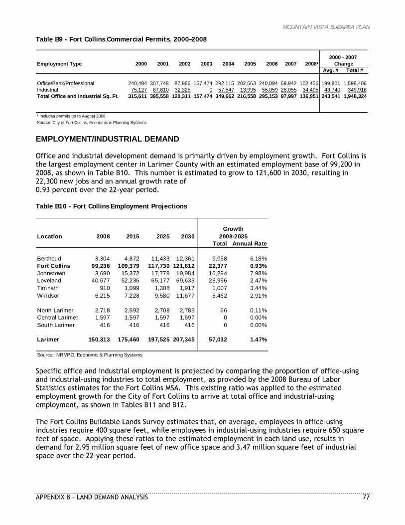
MOUNTAIN VISTA SUBAREA PLAN
APPENDIX B – LAND DEMAND ANALYSIS 77
Table B9 - Fort Collins Commercial Permits, 2000–2008
Employment Type 2000 2001 2002 2003 2004 2005 2006 2007 2008¹Avg. # Total #
Office/Bank/Professional 240,484 307,748 87,986 157,474 292,115 202,563 240,094 69,942 102,456 199,801 1,598,406Industrial 75,127 87,810 32,325 0 57,547 13,995 55,059 28,055 34,495 43,740 349,918Total Office and Industrial Sq. Ft. 315,611 395,558 120,311 157,474 349,662 216,558 295,153 97,997 136,951 243,541 1,948,324
¹ Includes permits up to August 2008Source: City of Fort Collins, Economic & Planning Systems
2000 - 2007 Change
EMPLOYMENT/INDUSTRIAL DEMAND Office and industrial development demand is primarily driven by employment growth. Fort Collins is the largest employment center in Larimer County with an estimated employment base of 99,200 in 2008, as shown in Table B10. This number is estimated to grow to 121,600 in 2030, resulting in 22,300 new jobs and an annual growth rate of 0.93 percent over the 22-year period. Table B10 - Fort Collins Employment Projections
Location 2008 2015 2025 2030Total Annual Rate
Berthoud 3,304 4,872 11,433 12,361 9,058 6.18%Fort Collins 99,236 109,379 117,730 121,612 22,377 0.93%Johnstown 3,690 15,372 17,779 19,984 16,294 7.98%Loveland 40,677 52,236 65,177 69,633 28,956 2.47%Timnath 910 1,099 1,308 1,917 1,007 3.44%Windsor 6,215 7,228 9,580 11,677 5,462 2.91%
North Larimer 2,718 2,592 2,708 2,783 66 0.11%Central Larimer 1,597 1,597 1,597 1,597 0 0.00%South Larimer 416 416 416 416 0 0.00%
Larimer 150,313 175,460 197,525 207,345 57,032 1.47%
Source: NRMPO, Economic & Planning Systems
2008-2035Growth
Specific office and industrial employment is projected by comparing the proportion of office-using and industrial-using industries to total employment, as provided by the 2008 Bureau of Labor Statistics estimates for the Fort Collins MSA. This existing ratio was applied to the estimated employment growth for the City of Fort Collins to arrive at total office and industrial-using employment, as shown in Tables B11 and B12. The Fort Collins Buildable Lands Survey estimates that, on average, employees in office-using industries require 400 square feet, while employees in industrial-using industries require 650 square feet of space. Applying these ratios to the estimated employment in each land use, results in demand for 2.95 million square feet of new office space and 3.47 million square feet of industrial space over the 22-year period.
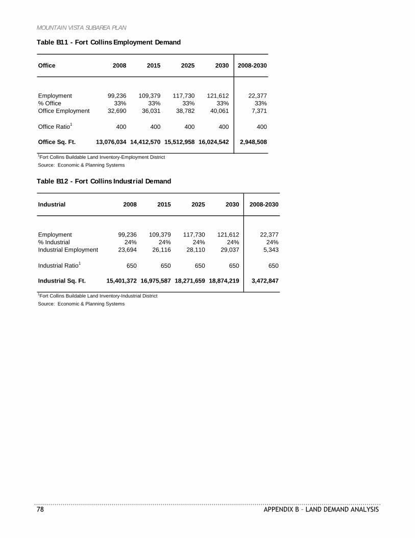
MOUNTAIN VISTA SUBAREA PLAN
78 APPENDIX B – LAND DEMAND ANALYSIS
Table B11 - Fort Collins Employment Demand
Office 2008 2015 2025 2030 2008-2030
Employment 99,236 109,379 117,730 121,612 22,377% Office 33% 33% 33% 33% 33%Office Employment 32,690 36,031 38,782 40,061 7,371
Office Ratio1 400 400 400 400 400
Office Sq. Ft. 13,076,034 14,412,570 15,512,958 16,024,542 2,948,508
1Fort Collins Buildable Land Inventory-Employment DistrictSource: Economic & Planning Systems Table B12 - Fort Collins Industrial Demand
Industrial 2008 2015 2025 2030 2008-2030
Employment 99,236 109,379 117,730 121,612 22,377% Industrial 24% 24% 24% 24% 24%Industrial Employment 23,694 26,116 28,110 29,037 5,343
Industrial Ratio1 650 650 650 650 650
Industrial Sq. Ft. 15,401,372 16,975,587 18,271,659 18,874,219 3,472,847
1Fort Collins Buildable Land Inventory-Industrial DistrictSource: Economic & Planning Systems
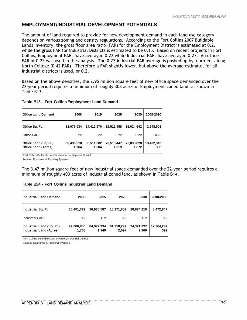
MOUNTAIN VISTA SUBAREA PLAN
APPENDIX B – LAND DEMAND ANALYSIS 79
EMPLOYMENT/INDUSTRIAL DEVELOPMENT POTENTIALS The amount of land required to provide for new development demand in each land use category depends on various zoning and density regulations. According to the Fort Collins 2007 Buildable Lands Inventory, the gross floor area ratio (FAR) for the Employment District is estimated at 0.2, while the gross FAR for Industrial Districts is estimated to be 0.15. Based on recent projects in Fort Collins, Employment FARs have averaged 0.22 while Industrial FARs have averaged 0.27. An office FAR of 0.22 was used in the analysis. The 0.27 industrial FAR average is pushed up by a project along North College (0.42 FAR). Therefore a FAR slightly lower, but above the average estimate, for all Industrial districts is used, or 0.2. Based on the above densities, the 2.95 million square feet of new office space demanded over the 22-year period requires a minimum of roughly 308 acres of Employment-zoned land, as shown in Table B13. Table B13 - Fort Collins Employment Land Demand
Office Land Demand 2008 2015 2025 2030 2008-2030
Office Sq. Ft. 13,076,034 14,412,570 15,512,958 16,024,542 2,948,508
Office FAR1 0.22 0.22 0.22 0.22 0.22
Office Land (Sq. Ft.) 59,436,518 65,511,682 70,513,447 72,838,828 13,402,310Office Land (Acres) 1,364 1,504 1,619 1,672 308
1Fort Collins Buildable Land Inventory- Employment DistrictSource: Economic & Planning Systems The 3.47 million square feet of new industrial space demanded over the 22-year period requires a minimum of roughly 400 acres of Industrial-zoned land, as shown in Table B14. Table B14 - Fort Collins Industrial Land Demand
Industrial Land Demand 2008 2015 2025 2030 2008-2030
Industrial Sq. Ft. 15,401,372 16,975,587 18,271,659 18,874,219 3,472,847
Industrial FAR1 0.2 0.2 0.2 0.2 0.2
Industrial Land (Sq. Ft.) 77,006,860 84,877,934 91,358,297 94,371,097 17,364,237Industrial Land (Acres) 1,768 1,949 2,097 2,166 399
1Fort Collins Buildable Land Inventory-Industrial DistrictSource: Economic & Planning Systems
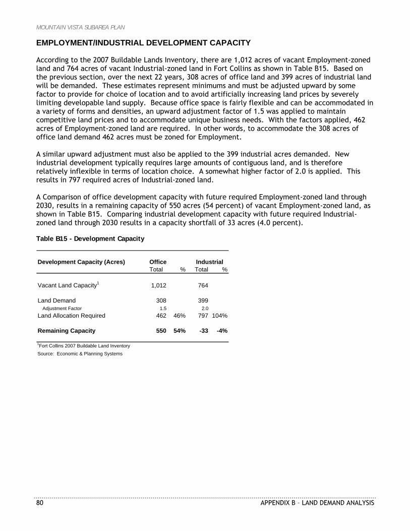
MOUNTAIN VISTA SUBAREA PLAN
80 APPENDIX B – LAND DEMAND ANALYSIS
EMPLOYMENT/INDUSTRIAL DEVELOPMENT CAPACITY According to the 2007 Buildable Lands Inventory, there are 1,012 acres of vacant Employment-zoned land and 764 acres of vacant Industrial-zoned land in Fort Collins as shown in Table B15. Based on the previous section, over the next 22 years, 308 acres of office land and 399 acres of industrial land will be demanded. These estimates represent minimums and must be adjusted upward by some factor to provide for choice of location and to avoid artificially increasing land prices by severely limiting developable land supply. Because office space is fairly flexible and can be accommodated in a variety of forms and densities, an upward adjustment factor of 1.5 was applied to maintain competitive land prices and to accommodate unique business needs. With the factors applied, 462 acres of Employment-zoned land are required. In other words, to accommodate the 308 acres of office land demand 462 acres must be zoned for Employment. A similar upward adjustment must also be applied to the 399 industrial acres demanded. New industrial development typically requires large amounts of contiguous land, and is therefore relatively inflexible in terms of location choice. A somewhat higher factor of 2.0 is applied. This results in 797 required acres of Industrial-zoned land. A Comparison of office development capacity with future required Employment-zoned land through 2030, results in a remaining capacity of 550 acres (54 percent) of vacant Employment-zoned land, as shown in Table B15. Comparing industrial development capacity with future required Industrial-zoned land through 2030 results in a capacity shortfall of 33 acres (4.0 percent). Table B15 - Development Capacity
Development Capacity (Acres)Total % Total %
Vacant Land Capacity1 1,012 764
Land Demand 308 399Adjustment Factor 1.5 2.0
Land Allocation Required 462 46% 797 104%
Remaining Capacity 550 54% -33 -4%
1Fort Collins 2007 Buildable Land InventorySource: Economic & Planning Systems
Office Industrial
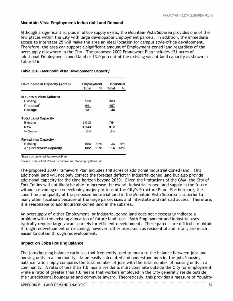
MOUNTAIN VISTA SUBAREA PLAN
APPENDIX B – LAND DEMAND ANALYSIS 81
Mountain Vista Employment/Industrial Land Demand Although a significant surplus in office supply exists, the Mountain Vista Subarea provides one of the few places within the City with large developable Employment parcels. In addition, the immediate access to Interstate 25 will make the area an ideal location for campus style office development. Therefore, the area can support a significant amount of Employment-zoned land regardless of the oversupply elsewhere in the City. The proposed 2009 Framework Plan includes 131 acres of additional Employment-zoned land or 13.0 percent of the existing vacant land capacity as shown in Table B16. Table B16 - Mountain Vista Development Capacity
Development Capacity (Acres)Total % Total %
Mountain Vista SubareaExisting 530 309Proposed1 661 457Change 131 148
Total Land CapacityExisting 1,012 764New 1,143 912% Change 13% 19%
Remaining CapacityExisting 550 54% -33 -4%Adjusted/New Capacity 682 60% 114 13%
1Based on preferred Framework PlanSource: City of Fort Collins, Economic and Planning Systems, Inc.
Employment Industrial
The proposed 2009 Framework Plan includes 148 acres of additional Industrial-zoned land. This additional land will not only correct the forecast deficit in Industrial-zoned land but also provide additional capacity for the time horizon beyond 2030. Given the limitations of the GMA, the City of Fort Collins will not likely be able to increase the overall Industrial-zoned land supply in the future without re-zoning or redeveloping major portions of the City’s Structure Plan. Furthermore, the condition and quality of the proposed industrial land in the Mountain Vista Subarea is superior to many other locations because of the large parcel sizes and interstate and railroad access. Therefore, it is reasonable to add Industrial-zoned land in the subarea. An oversupply of either Employment- or Industrial-zoned land does not necessarily indicate a problem with the existing allocation of future land uses. Both Employment and Industrial uses typically require large vacant parcels for efficient development. These parcels are difficult to obtain through redevelopment or re-zoning; however, other uses, such as residential and retail, are much easier to obtain through redevelopment. Impact on Jobs/Housing Balance The jobs/housing balance ratio is a tool frequently used to measure the balance between jobs and housing units in a community. As an easily calculated and understood metric, the jobs/housing balance ratio simply compares the total number of jobs with the total number of housing units in a community. A ratio of less than 1.0 means residents must commute outside the City for employment while a ratio of greater than 1.0 means that workers employed in the City generally reside outside the jurisdictional boundaries and commute inward. Theoretically, this provides a measure of “quality

MOUNTAIN VISTA SUBAREA PLAN
82 APPENDIX B – LAND DEMAND ANALYSIS
of life” by indicating the amount of commuting required to or from a community for employment, and thus, indirectly measures the level of traffic congestion and commute times. The meaning of the jobs/housing balance can often be overstated. In reality, many of the factors that influence this measure are driven by market forces beyond the control of the local community. These market forces include housing prices, housing preference, competitiveness of local businesses, local and state fiscal policy, and job availability. Instead, the measure is more useful for evaluating the overall character of a community as either a bedroom community (ratio of less than 1.0) or an employment center (ratio of 1.0 or greater). The increases in Employment- and Industrial-zoned land shown in the proposed 2009 Framework Plan will have a marginal impact on the forecasted jobs/housing balance ratio. Incorporating the proposed zoning changes increases the ratio from an estimated 1.50 under the exiting Mountain Vista Subarea Plan to 1.56 under the proposed Framework Plan. This small increase (well within the margin of error at approximately 2.6 percent) will have little effect on altering the future role of the City of Fort Collins. The City anticipates serving as an employment center for the North Front Range community in the future and will become marginally more so as a result of the proposed zoning changes. Medium Density Mixed-Use Neighborhood As part of the reevaluation of the residential and mixed-use zoning districts within the Mountain Vista Subarea, the City of Fort Collins requested that EPS examine future multifamily demand. This chapter of the report reviews recent multifamily growth in the Mountain Vista Subarea and the City as a whole. Future demand is forecast considering historic trends and changes in demographic conditions and residential preferences. HISTORIC HOUSEHOLD GROWTH Over the past eight years the City of Fort Collins has added 3,415 attached residential units, as displayed in Table B17. The amount of attached units accounts for approximately 33 percent of the 10,396 units built over the time period. On average, the City has added 533 attached residential units (including mixed-use) and 776 single-family units annually. Table B17 - Fort Collins Permits, 2000–2008
Type 2000 2001 2002 2003 2004 2005 2006 2007 2008 1
Avg. # Total #
Mixed-use n/a n/a n/a n/a n/a n/a 301 26 87 138 414Multi Family 601 738 312 425 308 244 127 160 431 372 3,346Single Family 982 1,113 1,222 985 988 736 439 308 208 776 6,981Single Family Attached n/a n/a n/a n/a n/a n/a 25 33 11 23 69Total 1,583 1,851 1,534 1,410 1,296 980 591 501 650 1,155 10,396
[Note] Mixed-use and single family attached included in multi family prior to 20061 Permits are through September 2008Source: City of Fort Collins; Economic & Planning Systems
2000 - 2008Change
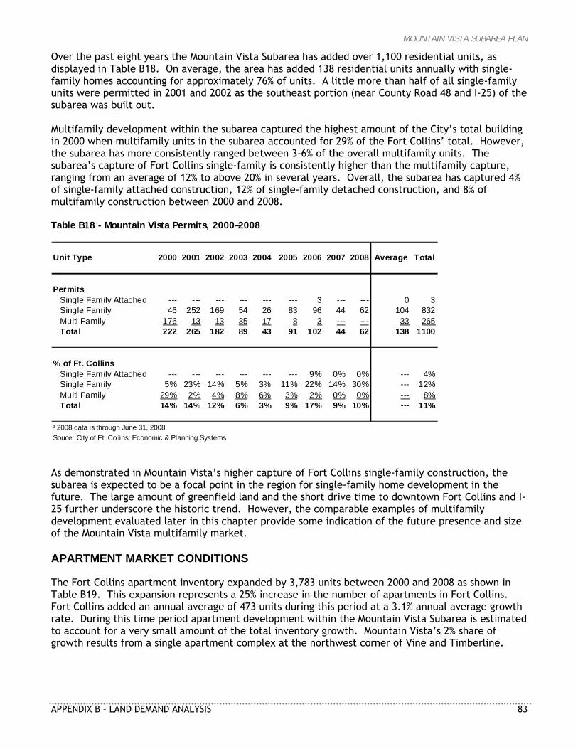
MOUNTAIN VISTA SUBAREA PLAN
APPENDIX B – LAND DEMAND ANALYSIS 83
Over the past eight years the Mountain Vista Subarea has added over 1,100 residential units, as displayed in Table B18. On average, the area has added 138 residential units annually with single-family homes accounting for approximately 76% of units. A little more than half of all single-family units were permitted in 2001 and 2002 as the southeast portion (near County Road 48 and I-25) of the subarea was built out. Multifamily development within the subarea captured the highest amount of the City’s total building in 2000 when multifamily units in the subarea accounted for 29% of the Fort Collins’ total. However, the subarea has more consistently ranged between 3-6% of the overall multifamily units. The subarea’s capture of Fort Collins single-family is consistently higher than the multifamily capture, ranging from an average of 12% to above 20% in several years. Overall, the subarea has captured 4% of single-family attached construction, 12% of single-family detached construction, and 8% of multifamily construction between 2000 and 2008. Table B18 - Mountain Vista Permits, 2000–2008
Unit Type 2000 2001 2002 2003 2004 2005 2006 2007 2008 Average Total
PermitsSingle Family Attached --- --- --- --- --- --- 3 --- --- 0 3Single Family 46 252 169 54 26 83 96 44 62 104 832Multi Family 176 13 13 35 17 8 3 --- --- 33 265Total 222 265 182 89 43 91 102 44 62 138 1100
% of Ft. CollinsSingle Family Attached --- --- --- --- --- --- 9% 0% 0% --- 4%Single Family 5% 23% 14% 5% 3% 11% 22% 14% 30% --- 12%Multi Family 29% 2% 4% 8% 6% 3% 2% 0% 0% --- 8%Total 14% 14% 12% 6% 3% 9% 17% 9% 10% --- 11%
¹ 2008 data is through June 31, 2008Souce: City of Ft. Collins; Economic & Planning Systems As demonstrated in Mountain Vista’s higher capture of Fort Collins single-family construction, the subarea is expected to be a focal point in the region for single-family home development in the future. The large amount of greenfield land and the short drive time to downtown Fort Collins and I-25 further underscore the historic trend. However, the comparable examples of multifamily development evaluated later in this chapter provide some indication of the future presence and size of the Mountain Vista multifamily market. APARTMENT MARKET CONDITIONS The Fort Collins apartment inventory expanded by 3,783 units between 2000 and 2008 as shown in Table B19. This expansion represents a 25% increase in the number of apartments in Fort Collins. Fort Collins added an annual average of 473 units during this period at a 3.1% annual average growth rate. During this time period apartment development within the Mountain Vista Subarea is estimated to account for a very small amount of the total inventory growth. Mountain Vista’s 2% share of growth results from a single apartment complex at the northwest corner of Vine and Timberline.
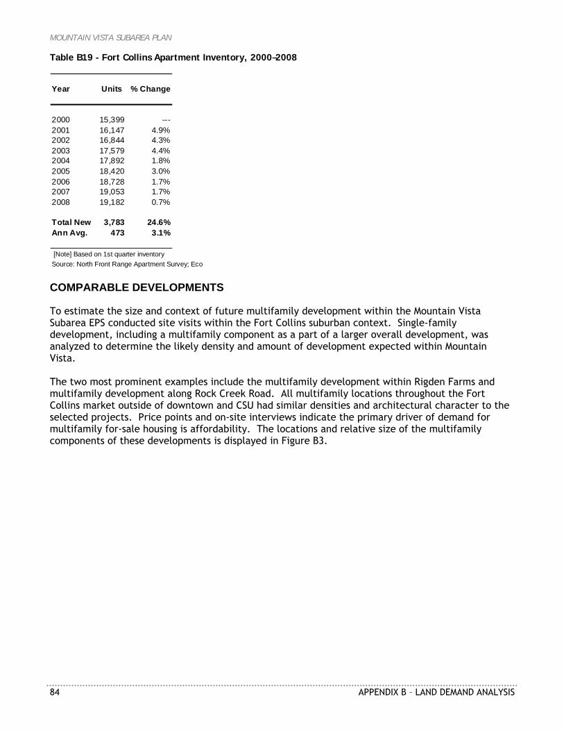
MOUNTAIN VISTA SUBAREA PLAN
84 APPENDIX B – LAND DEMAND ANALYSIS
Table B19 - Fort Collins Apartment Inventory, 2000–2008
Year Units % Change
2000 15,399 ---2001 16,147 4.9%2002 16,844 4.3%2003 17,579 4.4%2004 17,892 1.8%2005 18,420 3.0%2006 18,728 1.7%2007 19,053 1.7%2008 19,182 0.7%
Total New 3,783 24.6%Ann Avg. 473 3.1%
[Note] Based on 1st quarter inventorySource: North Front Range Apartment Survey; Eco COMPARABLE DEVELOPMENTS To estimate the size and context of future multifamily development within the Mountain Vista Subarea EPS conducted site visits within the Fort Collins suburban context. Single-family development, including a multifamily component as a part of a larger overall development, was analyzed to determine the likely density and amount of development expected within Mountain Vista. The two most prominent examples include the multifamily development within Rigden Farms and multifamily development along Rock Creek Road. All multifamily locations throughout the Fort Collins market outside of downtown and CSU had similar densities and architectural character to the selected projects. Price points and on-site interviews indicate the primary driver of demand for multifamily for-sale housing is affordability. The locations and relative size of the multifamily components of these developments is displayed in Figure B3.
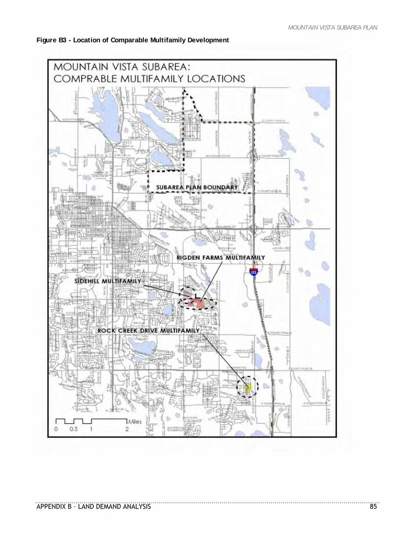
MOUNTAIN VISTA SUBAREA PLAN
APPENDIX B – LAND DEMAND ANALYSIS 85
Figure B3 - Location of Comparable Multifamily Development
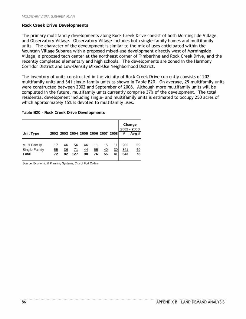
MOUNTAIN VISTA SUBAREA PLAN
86 APPENDIX B – LAND DEMAND ANALYSIS
Rock Creek Drive Developments The primary multifamily developments along Rock Creek Drive consist of both Morningside Village and Observatory Village. Observatory Village includes both single-family homes and multifamily units. The character of the development is similar to the mix of uses anticipated within the Mountain Village Subarea with a proposed mixed-use development directly west of Morningside Village, a proposed tech center at the northeast corner of Timberline and Rock Creek Drive, and the recently completed elementary and high schools. The developments are zoned in the Harmony Corridor District and Low-Density Mixed-Use Neighborhood District. The inventory of units constructed in the vicinity of Rock Creek Drive currently consists of 202 multifamily units and 341 single-family units as shown in Table B20. On average, 29 multifamily units were constructed between 2002 and September of 2008. Although more multifamily units will be completed in the future, multifamily units currently comprise 37% of the development. The total residential development including single- and multifamily units is estimated to occupy 250 acres of which approximately 15% is devoted to multifamily uses. Table B20 - Rock Creek Drive Developments
Unit Type 2002 2003 2004 2005 2006 2007 2008 # Avg #
Multi Family 17 46 56 46 11 15 11 202 29Single Family 55 36 71 44 65 40 30 341 49Total 72 82 127 90 76 55 41 543 78
Source: Economic & Planning Systems; City of Fort Collins
Change2002 - 2008
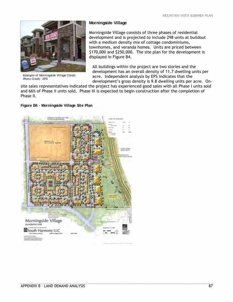
MOUNTAIN VISTA SUBAREA PLAN
APPENDIX B – LAND DEMAND ANALYSIS 87
Example of Morningside Village Condo Photo Credit: EPS
Morningside Village Morningside Village consists of three phases of residential development and is projected to include 298 units at buildout with a medium density mix of cottage condominiums, townhomes, and veranda homes. Units are priced between $170,000 and $250,000. The site plan for the development is displayed in Figure B4.
All buildings within the project are two stories and the development has an overall density of 11.7 dwelling units per acre. Independent analysis by EPS indicates that the development’s gross density is 9.8 dwelling units per acre. On-
site sales representatives indicated the project has experienced good sales with all Phase I units sold and 66% of Phase II units sold. Phase III is expected to begin construction after the completion of Phase II. Figure B4 - Morningside Village Site Plan
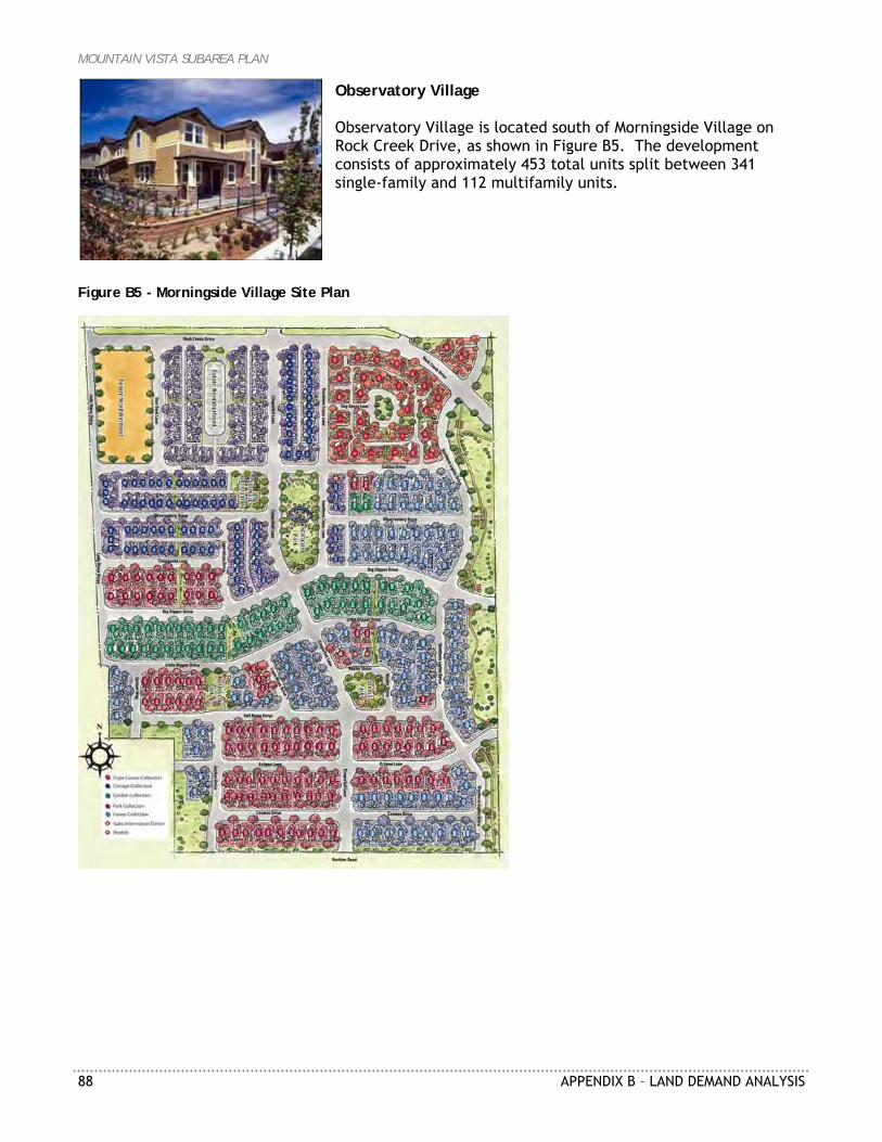
MOUNTAIN VISTA SUBAREA PLAN
88 APPENDIX B – LAND DEMAND ANALYSIS
Observatory Village Observatory Village is located south of Morningside Village on Rock Creek Drive, as shown in Figure B5. The development consists of approximately 453 total units split between 341 single-family and 112 multifamily units.
Figure B5 - Morningside Village Site Plan
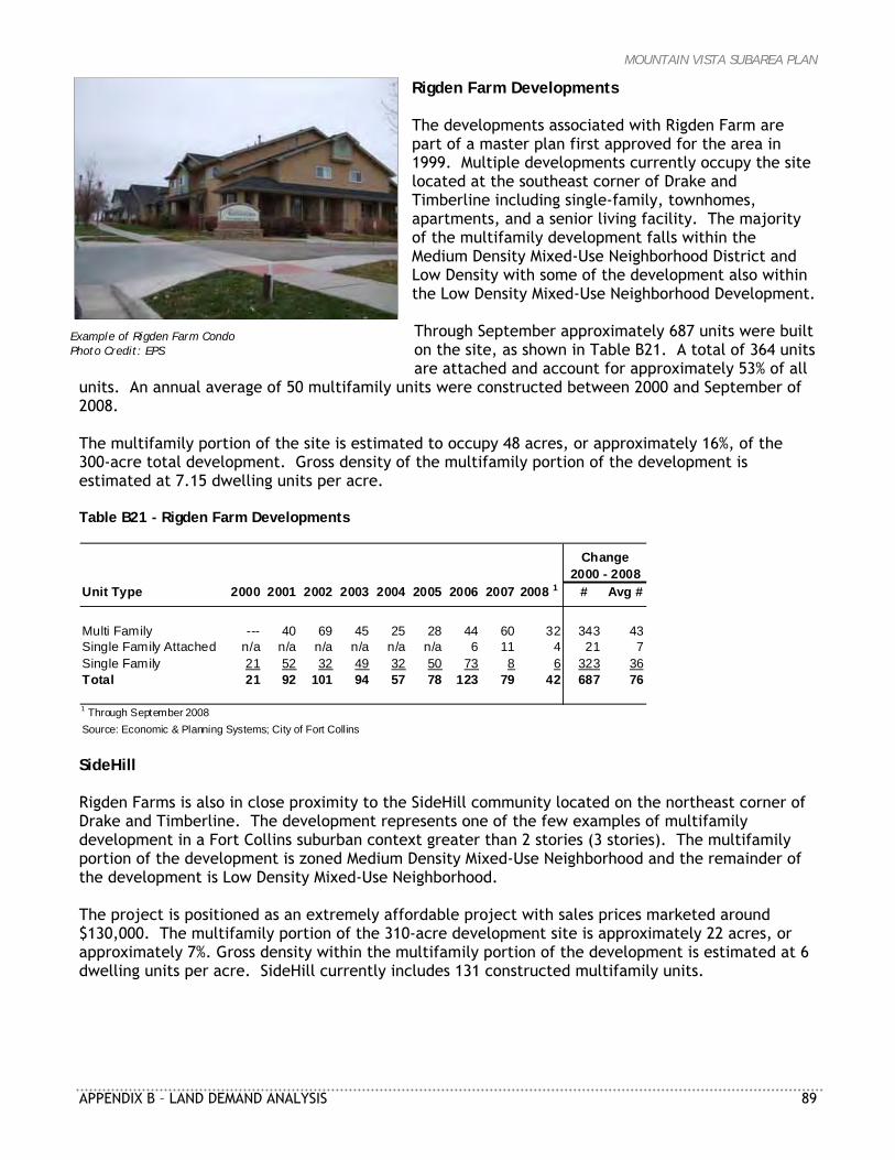
MOUNTAIN VISTA SUBAREA PLAN
APPENDIX B – LAND DEMAND ANALYSIS 89
Example of Rigden Farm Condo Photo Credit: EPS
Rigden Farm Developments The developments associated with Rigden Farm are part of a master plan first approved for the area in 1999. Multiple developments currently occupy the site located at the southeast corner of Drake and Timberline including single-family, townhomes, apartments, and a senior living facility. The majority of the multifamily development falls within the Medium Density Mixed-Use Neighborhood District and Low Density with some of the development also within the Low Density Mixed-Use Neighborhood Development. Through September approximately 687 units were built on the site, as shown in Table B21. A total of 364 units are attached and account for approximately 53% of all
units. An annual average of 50 multifamily units were constructed between 2000 and September of 2008. The multifamily portion of the site is estimated to occupy 48 acres, or approximately 16%, of the 300-acre total development. Gross density of the multifamily portion of the development is estimated at 7.15 dwelling units per acre. Table B21 - Rigden Farm Developments
Unit Type 2000 2001 2002 2003 2004 2005 2006 2007 2008 1 # Avg #
Multi Family --- 40 69 45 25 28 44 60 32 343 43Single Family Attached n/a n/a n/a n/a n/a n/a 6 11 4 21 7Single Family 21 52 32 49 32 50 73 8 6 323 36Total 21 92 101 94 57 78 123 79 42 687 76
1 Through September 2008Source: Economic & Planning Systems; City of Fort Collins
Change2000 - 2008
SideHill Rigden Farms is also in close proximity to the SideHill community located on the northeast corner of Drake and Timberline. The development represents one of the few examples of multifamily development in a Fort Collins suburban context greater than 2 stories (3 stories). The multifamily portion of the development is zoned Medium Density Mixed-Use Neighborhood and the remainder of the development is Low Density Mixed-Use Neighborhood. The project is positioned as an extremely affordable project with sales prices marketed around $130,000. The multifamily portion of the 310-acre development site is approximately 22 acres, or approximately 7%. Gross density within the multifamily portion of the development is estimated at 6 dwelling units per acre. SideHill currently includes 131 constructed multifamily units.
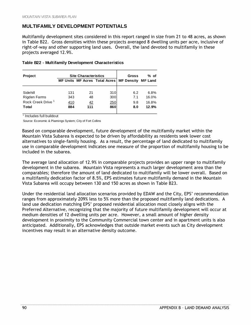
MOUNTAIN VISTA SUBAREA PLAN
90 APPENDIX B – LAND DEMAND ANALYSIS
MULTIFAMILY DEVELOPMENT POTENTIALS Multifamily development sites considered in this report ranged in size from 21 to 48 acres, as shown in Table B22. Gross densities within these projects averaged 8 dwelling units per acre, inclusive of right-of-way and other supporting land uses. Overall, the land devoted to multifamily in these projects averaged 12.9%. Table B22 - Multifamily Development Characteristics
Project Gross % ofMF Units MF Acres Total Acres MF Density MF Land
Sidehill 131 21 310 6.2 6.8%Rigden Farms 343 48 300 7.1 16.0%Rock Creek Drive 1 410 42 250 9.8 16.8%Total 884 111 860 8.0 12.9%
1 Includes full buildoutSource: Economic & Plannings System; City of Fort Collins
Site Characteristics
Based on comparable development, future development of the multifamily market within the Mountain Vista Subarea is expected to be driven by affordability as residents seek lower cost alternatives to single-family housing. As a result, the percentage of land dedicated to multifamily use in comparable development indicates one measure of the proportion of multifamily housing to be included in the subarea. The average land allocation of 12.9% in comparable projects provides an upper range to multifamily development in the subarea. Mountain Vista represents a much larger development area than the comparables; therefore the amount of land dedicated to multifamily will be lower overall. Based on a multifamily dedication factor of 8.5%, EPS estimates future multifamily demand in the Mountain Vista Subarea will occupy between 130 and 150 acres as shown in Table B23. Under the residential land allocation scenarios provided by EDAW and the City, EPS’ recommendation ranges from approximately 209% less to 5% more than the proposed multifamily land dedications. A land use dedication matching EPS’ proposed residential allocation most closely aligns with the Preferred Alternative, recognizing that the majority of future multifamily development will occur at medium densities of 12 dwelling units per acre. However, a small amount of higher density development in proximity to the Community Commercial town center and in apartment units is also anticipated. Additionally, EPS acknowledges that outside market events such as City development incentives may result in an alternative density outcome.
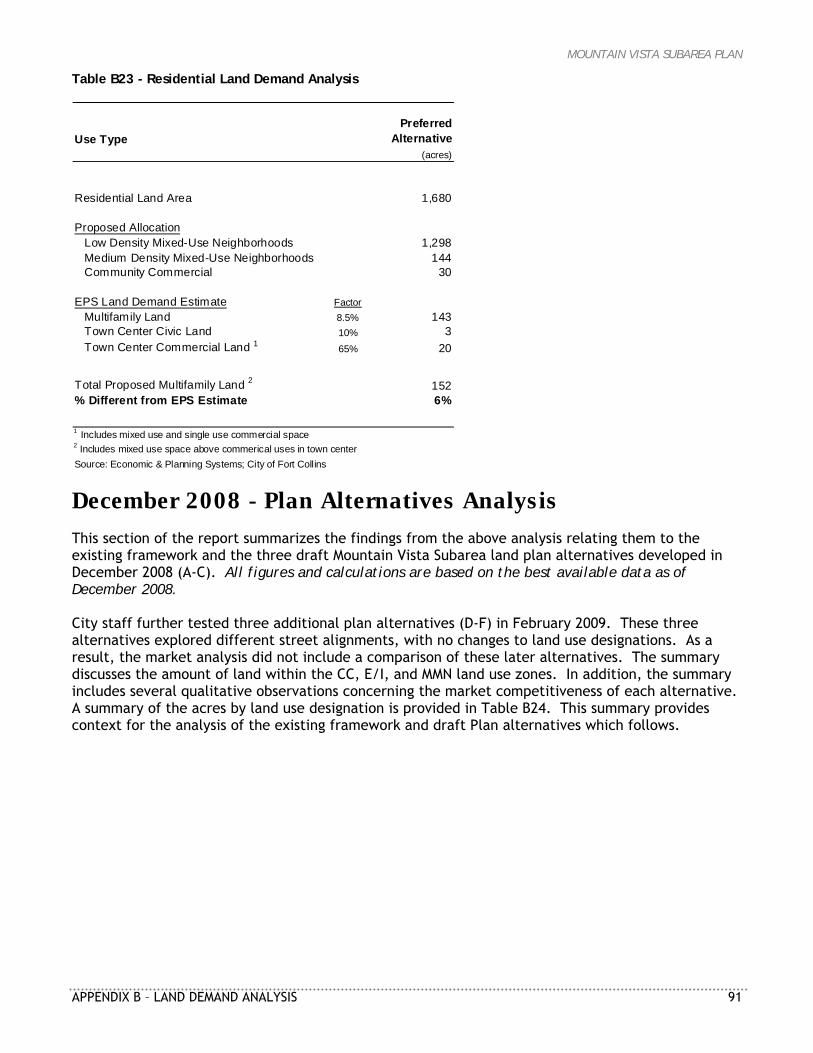
MOUNTAIN VISTA SUBAREA PLAN
APPENDIX B – LAND DEMAND ANALYSIS 91
Table B23 - Residential Land Demand Analysis
Use TypePreferred
Alternative(acres)
Residential Land Area 1,680
Proposed AllocationLow Density Mixed-Use Neighborhoods 1,298Medium Density Mixed-Use Neighborhoods 144Community Commercial 30
EPS Land Demand Estimate FactorMultifamily Land 8.5% 143Town Center Civic Land 10% 3Town Center Commercial Land 1 65% 20
Total Proposed Multifamily Land 2 152% Different from EPS Estimate 6%
1 Includes mixed use and single use commercial space2 Includes mixed use space above commerical uses in town centerSource: Economic & Planning Systems; City of Fort Collins
December 2008 - Plan Alternatives Analysis This section of the report summarizes the findings from the above analysis relating them to the existing framework and the three draft Mountain Vista Subarea land plan alternatives developed in December 2008 (A-C). All figures and calculations are based on the best available data as of December 2008. City staff further tested three additional plan alternatives (D-F) in February 2009. These three alternatives explored different street alignments, with no changes to land use designations. As a result, the market analysis did not include a comparison of these later alternatives. The summary discusses the amount of land within the CC, E/I, and MMN land use zones. In addition, the summary includes several qualitative observations concerning the market competitiveness of each alternative. A summary of the acres by land use designation is provided in Table B24. This summary provides context for the analysis of the existing framework and draft Plan alternatives which follows.
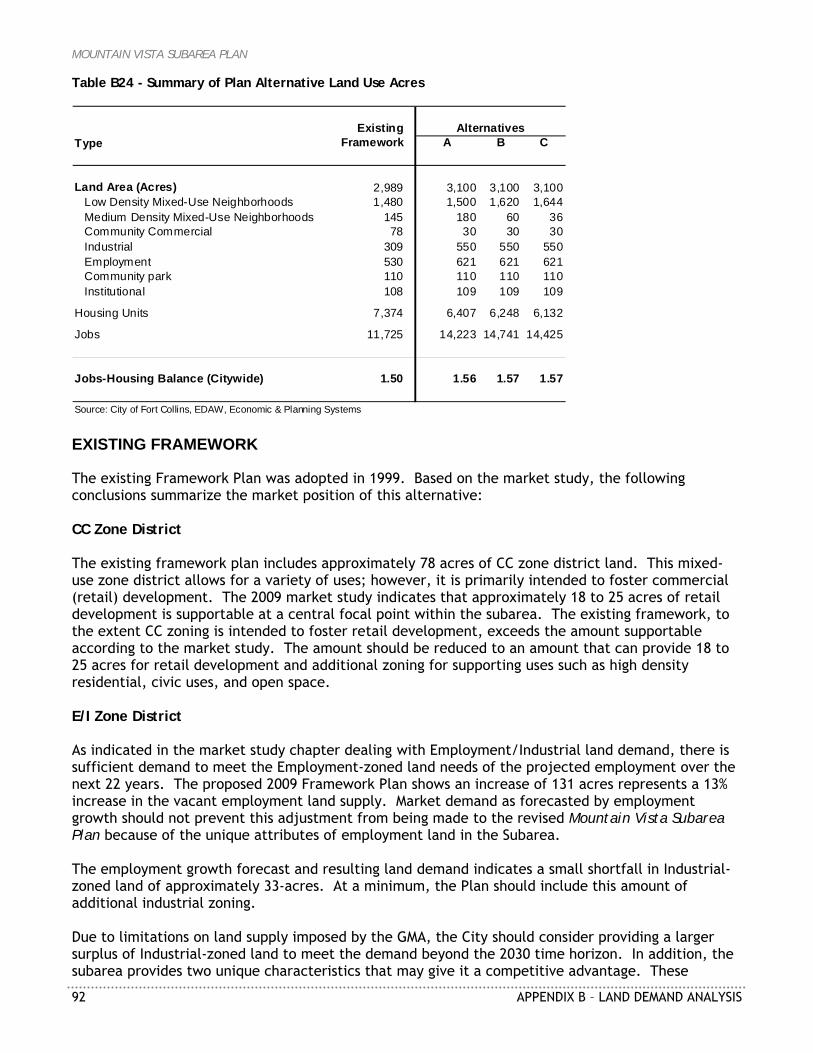
MOUNTAIN VISTA SUBAREA PLAN
92 APPENDIX B – LAND DEMAND ANALYSIS
Table B24 - Summary of Plan Alternative Land Use Acres
ExistingType Framework A B C
Land Area (Acres) 2,989 3,100 3,100 3,100Low Density Mixed-Use Neighborhoods 1,480 1,500 1,620 1,644Medium Density Mixed-Use Neighborhoods 145 180 60 36Community Commercial 78 30 30 30Industrial 309 550 550 550Employment 530 621 621 621Community park 110 110 110 110Institutional 108 109 109 109
Housing Units 7,374 6,407 6,248 6,132
Jobs 11,725 14,223 14,741 14,425
Jobs-Housing Balance (Citywide) 1.50 1.56 1.57 1.57
Source: City of Fort Collins, EDAW, Economic & Planning Systems
Alternatives
EXISTING FRAMEWORK The existing Framework Plan was adopted in 1999. Based on the market study, the following conclusions summarize the market position of this alternative: CC Zone District The existing framework plan includes approximately 78 acres of CC zone district land. This mixed-use zone district allows for a variety of uses; however, it is primarily intended to foster commercial (retail) development. The 2009 market study indicates that approximately 18 to 25 acres of retail development is supportable at a central focal point within the subarea. The existing framework, to the extent CC zoning is intended to foster retail development, exceeds the amount supportable according to the market study. The amount should be reduced to an amount that can provide 18 to 25 acres for retail development and additional zoning for supporting uses such as high density residential, civic uses, and open space. E/I Zone District As indicated in the market study chapter dealing with Employment/Industrial land demand, there is sufficient demand to meet the Employment-zoned land needs of the projected employment over the next 22 years. The proposed 2009 Framework Plan shows an increase of 131 acres represents a 13% increase in the vacant employment land supply. Market demand as forecasted by employment growth should not prevent this adjustment from being made to the revised Mountain Vista Subarea Plan because of the unique attributes of employment land in the Subarea. The employment growth forecast and resulting land demand indicates a small shortfall in Industrial-zoned land of approximately 33-acres. At a minimum, the Plan should include this amount of additional industrial zoning. Due to limitations on land supply imposed by the GMA, the City should consider providing a larger surplus of Industrial-zoned land to meet the demand beyond the 2030 time horizon. In addition, the subarea provides two unique characteristics that may give it a competitive advantage. These
MOUNTAIN VISTA SUBAREA PLAN
APPENDIX B – LAND DEMAND ANALYSIS 93
characteristics include: 1) large land parcels allowing for maximum development flexibility and 2) direct access to the interstate and railroad. These two characteristics make the Mountain Vista Subarea a good location for long-term industrial development. Therefore, the 131 acres of additional Industrial-zoned land should be included in the revised Mountain Vista Subarea Plan. MMN Zone District The existing 1999 Framework Plan includes approximately 145 acres of MMN land, located entirely adjacent to the CC zone. This exceeds the recommendation from the market study by 10 to 30 acres. With this 2009 update, the ideal locations for MMN land would be (1) adjacent to the CC zone district forming the core of the subarea, and (2) along any enhanced travel corridors. FRAMEWORK PLAN ALTERNATIVES ANALYSIS This section analyzes the Framework plan alternatives that were developed in December of 2008 in light of the market study findings. FRAMEWORK PLAN—ALTERNATIVE A This Framework plan alternative includes the realignment of Vine and Mountain Vista Drives. In addition, this plan includes the greatest amount of MMN zoned land. Based on the market study, the following conclusions summarize the market position of this alternative: CC Zone District At 30 acres, this zone district is sufficiently large enough to accommodate the supportable retail development in the subarea. The district will allow for a grocery store anchor integrated into a mixed-use town center including additional retail, residential, and office development. This 30-acre zone district will form the nucleus of the town center, which should include other zone districts to encourage medium density multifamily residential, civic uses, and parks. The CC zone district is located at the intersection of Mountain Vista Drive and a secondary arterial. A location at two major arterials, such as Vine and Mountain Vista, would generate a greater amount of drive-by traffic to support retail uses. However, the proposed location is relatively close to the existing residential development and well positioned to take advantage of early residential development in the subarea (assumed to move from the southwest corner to the east). In addition, the land demand analysis supports an additional smaller neighborhood-oriented retail district in the early years of development. An ideal location for this 4- to 6-acre site would be at the intersection of Mountain Vista Drive and East Vine Drive. The site will likely include between 30,000 to 40,000 square feet of retail, restaurant, and service space providing convenience oriented goods and services to the surrounding neighborhood. E/I Zone District As indicated in the market study chapter dealing with Employment/Industrial land demand, there is sufficient demand to meet the Employment-zoned land needs of the projected employment over the next 22 years. The existing 329 acres of Employment-zoned land comprises a portion of the existing 1,012 acres of vacant land. Therefore, the existing zoning in the Mountain Vista area contributes to the excess supply of employment land citywide. The employment growth forecast and resulting land demand indicates a small shortfall in Industrial-zoned land of approximately 33 acres. The existing 530 acres of Industrial-zoned land in the
MOUNTAIN VISTA SUBAREA PLAN
94 APPENDIX B – LAND DEMAND ANALYSIS
Mountain Vista Subarea was included in the land demand analysis. Therefore, the existing zoning both citywide and in the subarea do not meet the anticipated Industrial-zoned land needed between 2008 and 2030, let alone the potential need beyond 2030. The additional 176 acres of industrial land will preserve a supply of land for the projected industrial demands of Fort Collins. MMN Zone District This alternative includes approximately 180 acres of MMN zoned land. There is approximately 30 acres adjacent to the proposed CC zone district. This amount is the minimum amount that should be zoned around this focal point of the subarea plan. Similar subareas in Fort Collins have included between 40 and 50 acres of MMN land in their central districts. In addition, this alternative includes approximately 110 acres of MMN zoned land along the enhanced travel corridor. An enhanced travel corridor is an ideal location for medium density multifamily development. However, as indicated in the market study, the maximum MMN zoning supportable in the subarea ranges from 130 to 150 acres. Therefore, the amount of MMN along this corridor is likely more than the market will support in the time horizon evaluated (2008 to 2030). FRAMEWORK PLAN—ALTERNATIVE B This framework plan alternative includes the realignment of Vine creating a focal point for development at the intersection of Vine and Timberline. Based on the market study, the following conclusions summarize the market position of this alternative: CC Zone District At 30 acres this zone district is sufficiently large enough to accommodate the anticipated retail development supportable in the subarea. The district will allow for a grocery store anchor integrated into a mixed-use town center including additional retail, residential, and office development. This 30-acre zone district will form the nucleus of the town center, which should include other zone districts to encourage medium density multifamily residential, civic uses, and parks. The location of the CC zone district at the intersection of Vine and Timberline places it at a major intersection within the subarea. This location is well suited to generate the necessary drive-by traffic that will provide additional support to retail development. In addition, the proposed location is relatively close to the existing residential development and well positioned to take advantage of early residential development in the subarea (assumed to move from the southwest corner to the east). In addition, the land demand analysis supports an additional smaller neighborhood oriented retail district in the early years of development. An ideal location for this 4 to 6 acres site would be at the intersection of Vine and Lemay. The site will likely include between 30,000 to 40,000 square feet of retail, restaurant, and service space providing convenience oriented goods and services to the surrounding neighborhood. E/I Zone District As indicated in the market study chapter dealing with Employment/Industrial land demand, there is sufficient demand to meet the Employment-zoned land needs of the projected employment over the next 22 years. The proposed increase of 131 acres represents a 13% increase in the vacant employment land supply. Market demand as forecasted by employment growth should not prevent
MOUNTAIN VISTA SUBAREA PLAN
APPENDIX B – LAND DEMAND ANALYSIS 95
this adjustment from being made to the revised Mountain Vista Subarea Plan because of the unique attributes of this area’s employment land. The employment growth forecast and resulting land demand indicates a small shortfall in Industrial-zoned land of approximately 33-acres. At a minimum, the plan should include this amount of additional industrial zoning. However, due to the GMA limitations, the City should consider providing a larger surplus of Industrial-zoned land to meet the demand beyond the 2030 time horizon. In addition, the subarea provides two unique characteristics that may give it a competitive advantage. These characteristics include: 1) large land parcels allowing for maximum development flexibility, and 2) direct access to the interstate and railroad. These two characteristics make the Mountain Vista Subarea a good location for long-term industrial development. Therefore, the 148 acres of additional Industrial-zoned land should be included in the revised Mountain Vista Subarea Plan. MMN Zone District This alternative includes approximately 60 acres of MMN zoned land. Approximately 40 to 50 acres of this land should be adjacent to the CC zone district to help create a mixed-use town center supported by medium density multifamily. The remaining 10 to 20 acres could be located elsewhere in the subarea. Ideal locations would include other major arterial intersections or along the enhanced travel corridor. These satellite locations would be ideal for apartment development. FRAMEWORK PLAN—ALTERNATIVE C This framework plan alternative includes the realignment of Vine and enhancement of Timberline to Mountain Vista. Based on the market study, the following conclusions summarize the market position of this alternative: CC Zone District At 30 acres this zone district is sufficient large enough to accommodate the anticipated retail development supportable in the subarea. The district will allow for a grocery store anchor integrated into a mixed-use town center including additional retail, residential, and office development. This 30-acre zone district will form the nucleus of the town center, which should include other zone districts to encourage medium density multifamily residential, civic uses, and parks. The location of the CC zone district at the intersection of Timberline and Mountain Vista is the further away from existing residential and early future development of residential. This will likely delay the development of retail at the town center. In addition, the land demand analysis supports an additional smaller neighborhood oriented retail district in the early years of development. An ideal location for this 4 to 6 acres site would be at the intersection of Vine and Lemay. The site will likely include between 30,000 to 40,000 square feet of retail, restaurant, and service space providing convenience oriented goods and services to the surrounding neighborhood. E/I Zone District As indicated in the market study chapter dealing with Employment/Industrial land demand, there is sufficient demand to meet the Employment-zoned land needs of the projected employment over the next 22 years. The proposed increase of 131 acres represents a 13% increase in the vacant employment land supply. Market demand as forecasted by employment growth should not prevent

MOUNTAIN VISTA SUBAREA PLAN
96 APPENDIX B – LAND DEMAND ANALYSIS
this adjustment from being made to the revised Mountain Vista Subarea Plan because of the unique attributes of this area’s employment land. The employment growth forecast and resulting land demand indicates a small shortfall in Industrial-zoned land of approximately 33-acres. At a minimum, the Plan should include this amount of additional industrial zoning. However, due to the GMA limitations, the City should consider providing a larger surplus of Industrial-zoned land to meet the demand beyond the 2030 time horizon. In addition, the subarea provides two unique characteristics that may give it a competitive advantage including: 1) large land parcels allowing for maximum development flexibility, and 2) direct access to the interstate and railroad. These two characteristics make the Mountain Vista Subarea a good location for long-term industrial development. Therefore, the 148 acres of additional Industrial-zoned land should be included in the revised Mountain Vista Subarea Plan. A sizable zone district is located immediately east of the proposed CC zone district. This alternative attempts to create a greater synergy between employment uses and retail development. However, the location of this employment serves to eliminate a major part of the proposed retail market area. Employees contribute significantly less expenditure potential than a residential unit, in some locations one-tenth to one-twentieth of the expenditure potential. Therefore, this relationship may not be beneficial for retail development at the core of the subarea. The relationship does achieve other land use planning goals that may still make it a reasonable zoning decision. MMN Zone District This alternative includes approximately 36 acres of MMN zoned land all of which is located adjacent to the CC zone district. This is the ideal location for the MMN land in this alternative. According to the analysis of competitive locations, the subarea could support more MMN land than is included in this alternative. Additional Framework Plan Alternatives In all, City staff developed six Framework Plan alternatives between the fall of 2008, and March, 2009 (See Figures B6-B11). This Land Demand Analysis Report includes an assessment of the first three Alternatives.

MOUNTAIN VISTA SUBAREA PLAN
APPENDIX B – LAND DEMAND ANALYSIS 97
Figure B6 - Framework Plan—Alternative A
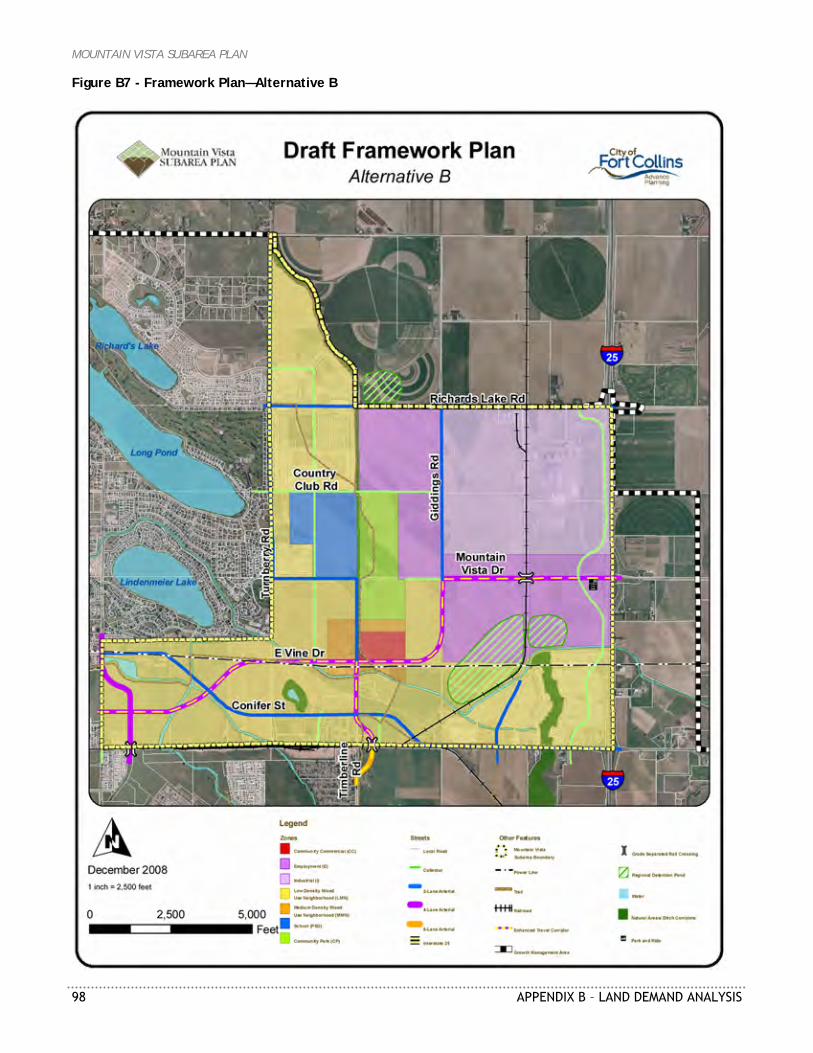
MOUNTAIN VISTA SUBAREA PLAN
98 APPENDIX B – LAND DEMAND ANALYSIS
Figure B7 - Framework Plan—Alternative B
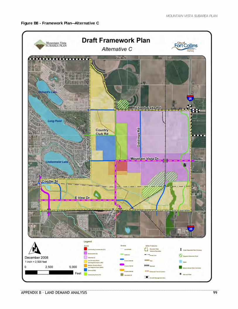
MOUNTAIN VISTA SUBAREA PLAN
APPENDIX B – LAND DEMAND ANALYSIS 99
Figure B8 - Framework Plan—Alternative C
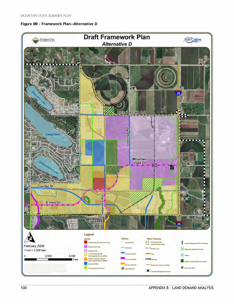
MOUNTAIN VISTA SUBAREA PLAN
100 APPENDIX B – LAND DEMAND ANALYSIS
Figure B9 - Framework Plan—Alternative D
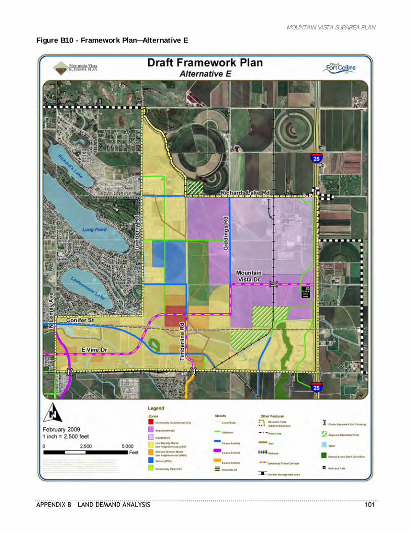
MOUNTAIN VISTA SUBAREA PLAN
APPENDIX B – LAND DEMAND ANALYSIS 101
Figure B10 - Framework Plan—Alternative E
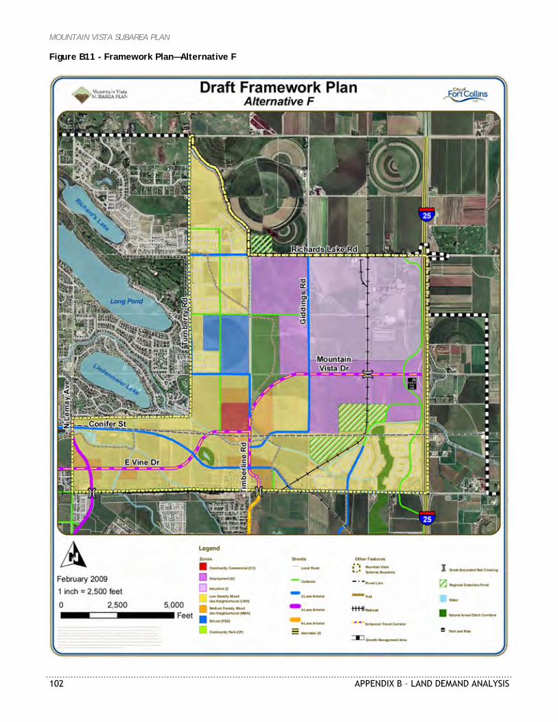
MOUNTAIN VISTA SUBAREA PLAN
102 APPENDIX B – LAND DEMAND ANALYSIS
Figure B11 - Framework Plan—Alternative F
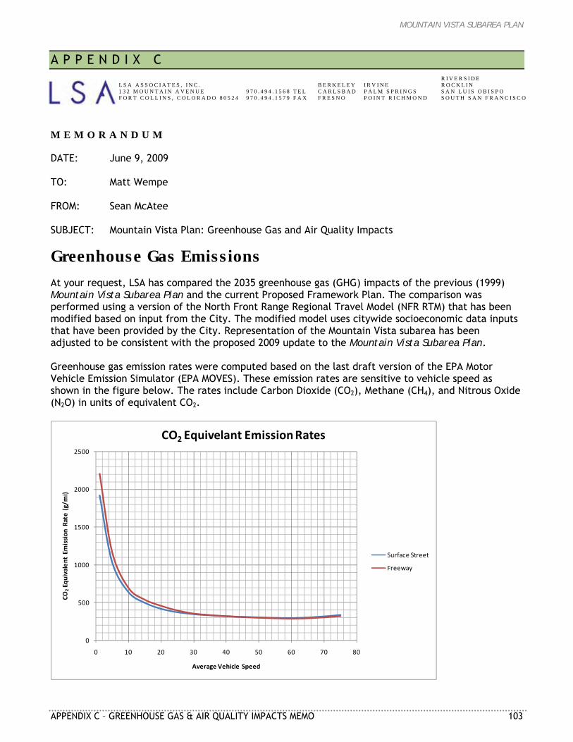
MOUNTAIN VISTA SUBAREA PLAN
APPENDIX C – GREENHOUSE GAS & AIR QUALITY IMPACTS MEMO 103
A P P E N D I X C M E M O R A N D U M DATE: June 9, 2009 TO: Matt Wempe FROM: Sean McAtee SUBJECT: Mountain Vista Plan: Greenhouse Gas and Air Quality Impacts
Greenhouse Gas Emissions At your request, LSA has compared the 2035 greenhouse gas (GHG) impacts of the previous (1999) Mountain Vista Subarea Plan and the current Proposed Framework Plan. The comparison was performed using a version of the North Front Range Regional Travel Model (NFR RTM) that has been modified based on input from the City. The modified model uses citywide socioeconomic data inputs that have been provided by the City. Representation of the Mountain Vista subarea has been adjusted to be consistent with the proposed 2009 update to the Mountain Vista Subarea Plan. Greenhouse gas emission rates were computed based on the last draft version of the EPA Motor Vehicle Emission Simulator (EPA MOVES). These emission rates are sensitive to vehicle speed as shown in the figure below. The rates include Carbon Dioxide (CO2), Methane (CH4), and Nitrous Oxide (N2O) in units of equivalent CO2.
0
500
1000
1500
2000
2500
0 10 20 30 40 50 60 70 80
CO2Equivalent Emission
Rate (g/m
i)
Average Vehicle Speed
CO2 Equivelant Emission Rates
Surface Street
Freeway
L S A A S S O C I A T E S , I N C . 1 3 2 M O U N T A I N A V E N U E F O R T C O L L I N S , C O L O R A D O 8 0 5 2 4
9 7 0 . 4 9 4 . 1 5 6 8 T E L 9 7 0 . 4 9 4 . 1 5 7 9 F A X
B E R K E L E Y C A R L S B A D F R E S N O
I R V I N E P A L M S P R I N G S P O I N T R I C H M O N D
R I V E R S I D E R O C K L I N S A N L U I S O B I S P O S O U T H S A N F R A N C I S C O
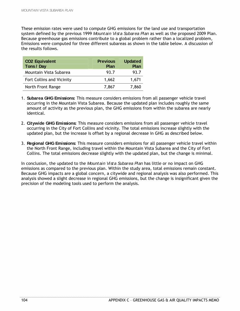
MOUNTAIN VISTA SUBAREA PLAN
104 APPENDIX C – GREENHOUSE GAS & AIR QUALITY IMPACTS MEMO
These emission rates were used to compute GHG emissions for the land use and transportation system defined by the previous 1999 Mountain Vista Subarea Plan as well as the proposed 2009 Plan. Because greenhouse gas emissions contribute to a global problem rather than a localized problem, Emissions were computed for three different subareas as shown in the table below. A discussion of the results follows.
CO2 Equivalent Tons / Day
Previous Plan
Updated Plan
Mountain Vista Subarea 93.7 93.7
Fort Collins and Vicinity 1,662 1,671
North Front Range 7,867 7,860 1. Subarea GHG Emissions: This measure considers emissions from all passenger vehicle travel
occurring in the Mountain Vista Subarea. Because the updated plan includes roughly the same amount of activity as the previous plan, the GHG emissions from within the subarea are nearly identical.
2. Citywide GHG Emissions: This measure considers emissions from all passenger vehicle travel
occurring in the City of Fort Collins and vicinity. The total emissions increase slightly with the updated plan, but the increase is offset by a regional decrease in GHG as described below.
3. Regional GHG Emissions: This measure considers emissions for all passenger vehicle travel within
the North Front Range, including travel within the Mountain Vista Subarea and the City of Fort Collins. The total emissions decrease slightly with the updated plan, but the change is minimal.
In conclusion, the updated to the Mountain Vista Subarea Plan has little or no impact on GHG emissions as compared to the previous plan. Within the study area, total emissions remain constant. Because GHG impacts are a global concern, a citywide and regional analysis was also performed. This analysis showed a slight decrease in regional GHG emissions, but the change is insignificant given the precision of the modeling tools used to perform the analysis.
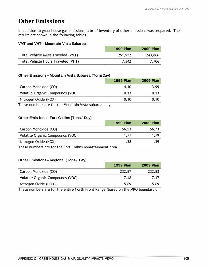
MOUNTAIN VISTA SUBAREA PLAN
APPENDIX C – GREENHOUSE GAS & AIR QUALITY IMPACTS MEMO 105
Other Emissions In addition to greenhouse gas emissions, a brief inventory of other emissions was prepared. The results are shown in the following tables. VMT and VHT – Mountain Vista Subarea
1999 Plan 2009 Plan
Total Vehicle Miles Traveled (VMT) 251,952 243,866
Total Vehicle Hours Traveled (VHT) 7,342 7,706 Other Emissions – Mountain Vista Subarea (Tons/Day)
1999 Plan 2009 Plan
Carbon Monoxide (CO) 4.10 3.99
Volatile Organic Compounds (VOC) 0.13 0.13
Nitrogen Oxide (NOX) 0.10 0.10 These numbers are for the Mountain Vista subarea only. Other Emissions – Fort Collins (Tons / Day)
1999 Plan 2009 Plan
Carbon Monoxide (CO) 56.53 56.73
Volatile Organic Compounds (VOC) 1.77 1.79
Nitrogen Oxide (NOX) 1.38 1.39 These numbers are for the Fort Collins nonattainment area. Other Emissions – Regional (Tons / Day)
1999 Plan 2009 Plan
Carbon Monoxide (CO) 232.87 232.83
Volatile Organic Compounds (VOC) 7.48 7.47
Nitrogen Oxide (NOX) 5.69 5.69 These numbers are for the entire North Front Range (based on the MPO boundary).
MOUNTAIN VISTA SUBAREA PLAN
106 APPENDIX C – GREENHOUSE GAS & AIR QUALITY IMPACTS MEMO
MOUNTAIN VISTA SUBAREA PLAN
APPENDIX D – TRAFFIC NOISE EVALUATION REPORT 107
A P P E N D I X D
MOUNTAIN VISTA SUBAREA PLAN TRAFFIC NOISE EVALUATION REPORT
Prepared for: City of Fort Collins 250 N. Mason Street Fort Collins, CO 80522 Prepared by: Felsburg Holt & Ullevig 6300 South Syracuse Way, Suite 600 Centennial, CO 80111 303/721-1440 FHU Reference No. 08-164 July 2009
MOUNTAIN VISTA SUBAREA PLAN
108 APPENDIX D – TRAFFIC NOISE EVALUATION REPORT
Introduction As part of the long range planning activities by the City of Fort Collins for the Mountain Vista subarea, traffic noise levels that would result from planned major street improvements have been examined. The Mountain Vista subarea (Figure D1) is located in northeast Fort Collins, Colorado within Larimer County. Currently, much of the subarea is undeveloped and unimproved. Major new or relocated arterial streets are envisioned within the long-range plan for this subarea. The purpose of this traffic noise analysis is to assess the future traffic noise levels from the street improvements for compatibility with future developed uses of the adjoining properties within the subarea. The proposed major road improvements include: Redesigning the Timberline Road connection to Mountain Vista Drive Widening Mountain Vista Drive, Timberline Road and Lemay Avenue Completing Vine Drive along a new alignment Completing connection of Conifer Street
The following report presents an overall traffic noise analysis that was performed to assess potential traffic noise levels at various distances from these road improvements. Train noise has not been included. This assessment is intended to provide supporting data for decisions regarding land use planning in the subarea. Generally speaking, residences are a land use more sensitive to (and incompatible with) high traffic noise levels. This is important for the Mountain Vista subarea, given that substantial residential development is planned here. While it is desirable to have residential noise levels as low as possible, real-world experience shows that it is very difficult to achieve low noise levels in developed areas. Often, the access routes to the residential areas are sources of noise that inhibit achievement of low overall noise levels. Often, a balance must be struck between low traffic noise levels and sensible land development.
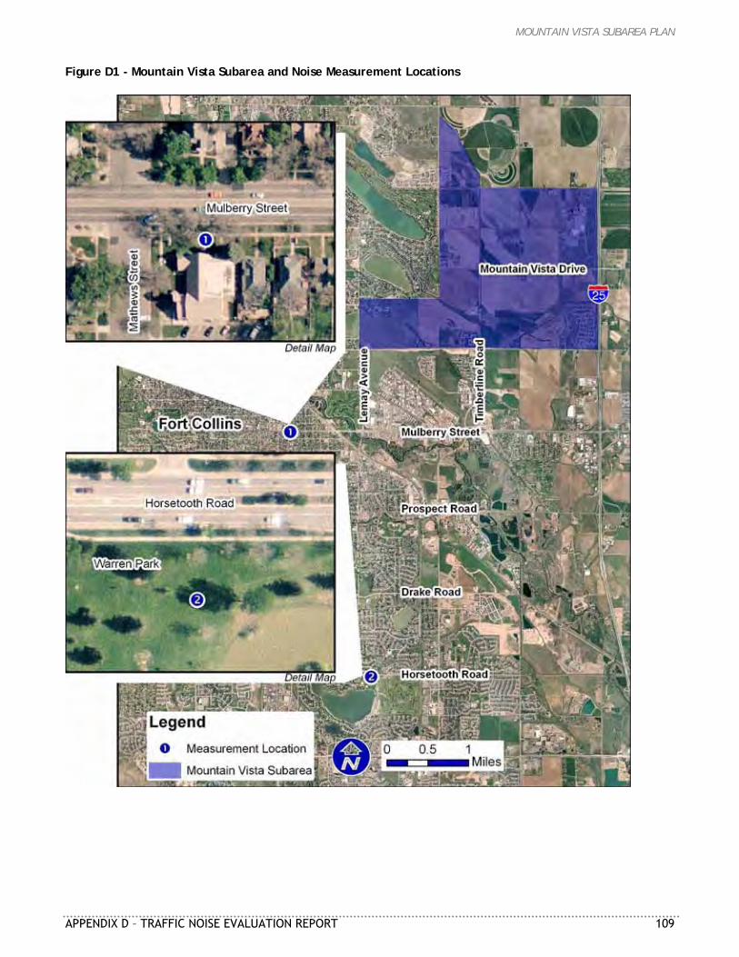
MOUNTAIN VISTA SUBAREA PLAN
APPENDIX D – TRAFFIC NOISE EVALUATION REPORT 109
Figure D1 - Mountain Vista Subarea and Noise Measurement Locations
MOUNTAIN VISTA SUBAREA PLAN
110 APPENDIX D – TRAFFIC NOISE EVALUATION REPORT
Methods The City of Fort Collins does not have regulations geared specifically toward routine traffic noise from streets. The City does have nuisance noise regulations (Fort Collins Municipal Code Chapter 20), including those for individual motor vehicles. However, the regulations specifically exempt the City for noise from public rights-of-way. Moreover, conforming individual vehicles could cumulatively cause traffic noise concerns. So, the City does not have specific noise regulations by which to evaluate the potential future traffic noise conditions. Therefore, three related noise criteria that have been developed by others were selected for discussion in this project. These noise criteria are based on either of two noise level metrics: the 1-hour equivalent sound level (Leq), which is the 1-hour “average” sound level; or the day-night level (Ldn), which is the 24-hour “average” sound level with a 10-decibel (dB) penalty for noise between 10 PM and 7 AM. The three selected criteria are described below and the corresponding numeric values are listed in Table D1: Colorado Department of Transportation’s (CDOT’s) Noise Abatement Criteria, regularly used to
assess highway noise U.S. Department of Housing and Urban Development (HUD) noise regulation (24 CFR Part 51B),
regularly used to assess housing projects applying for federal funding U.S. Environmental Protection Agency (EPA) recommended noise levels, identified by EPA as
requisite to protect public health and welfare Table D1 - Residential Noise Limits Included in Analysis
Agency Acceptable Residential Noise Level
Type of Sound Level Value
CDOT < 66 dB Leq
HUD ≤ 65 dB Ldn
EPAa ≤ 55 dB Ldn
a Recommended noise level, but does not consider technical feasibility or cost The noise analysis is based on a combination of noise measurements and computer modeling. Noise measurements were made to document conditions along existing corridors comparable to these planned for Mountain Vista. Modeling was performed to predict future traffic noise conditions along the major study area roads. Two noise measurements were made for the project (Figure D1). The first measurement was made in the yard of Peak Community Church at 500 Mathews Street, approximately 27 feet from traffic on Mulberry Street. The second measurement was in Warren Park, at approximately 1201 E. Horsetooth Road and approximately 100 feet from traffic. The measurements began on June 4 and June 24, 2009, respectively. Each measurement consisted of 24 consecutive 1-hour cumulative measurements with ambient sound levels logged each second. Traffic on adjoining streets was not counted due to the nature of the measurements. The noise modeling used the Federal Highway Administration’s Traffic Noise Model (TNM) Version 2.5 software to predict Year 2035 traffic noise levels for the major study area roads (Figure D2). The streets analyzed included Lemay Avenue, new Vine Drive, old Vine Drive, Conifer Street, Timberline Drive and Mountain Vista Drive. Traffic volumes for 2035 were provided by LSA Associates, Inc.
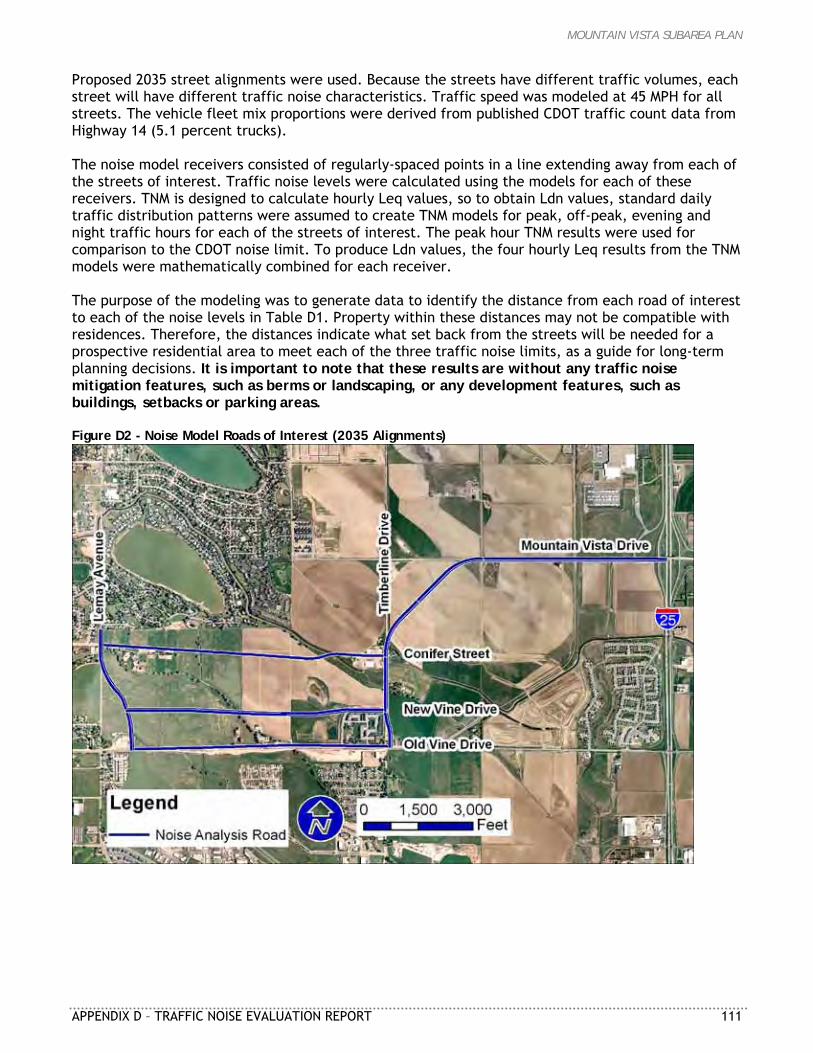
MOUNTAIN VISTA SUBAREA PLAN
APPENDIX D – TRAFFIC NOISE EVALUATION REPORT 111
Proposed 2035 street alignments were used. Because the streets have different traffic volumes, each street will have different traffic noise characteristics. Traffic speed was modeled at 45 MPH for all streets. The vehicle fleet mix proportions were derived from published CDOT traffic count data from Highway 14 (5.1 percent trucks). The noise model receivers consisted of regularly-spaced points in a line extending away from each of the streets of interest. Traffic noise levels were calculated using the models for each of these receivers. TNM is designed to calculate hourly Leq values, so to obtain Ldn values, standard daily traffic distribution patterns were assumed to create TNM models for peak, off-peak, evening and night traffic hours for each of the streets of interest. The peak hour TNM results were used for comparison to the CDOT noise limit. To produce Ldn values, the four hourly Leq results from the TNM models were mathematically combined for each receiver. The purpose of the modeling was to generate data to identify the distance from each road of interest to each of the noise levels in Table D1. Property within these distances may not be compatible with residences. Therefore, the distances indicate what set back from the streets will be needed for a prospective residential area to meet each of the three traffic noise limits, as a guide for long-term planning decisions. It is important to note that these results are without any traffic noise mitigation features, such as berms or landscaping, or any development features, such as buildings, setbacks or parking areas. Figure D2 - Noise Model Roads of Interest (2035 Alignments)
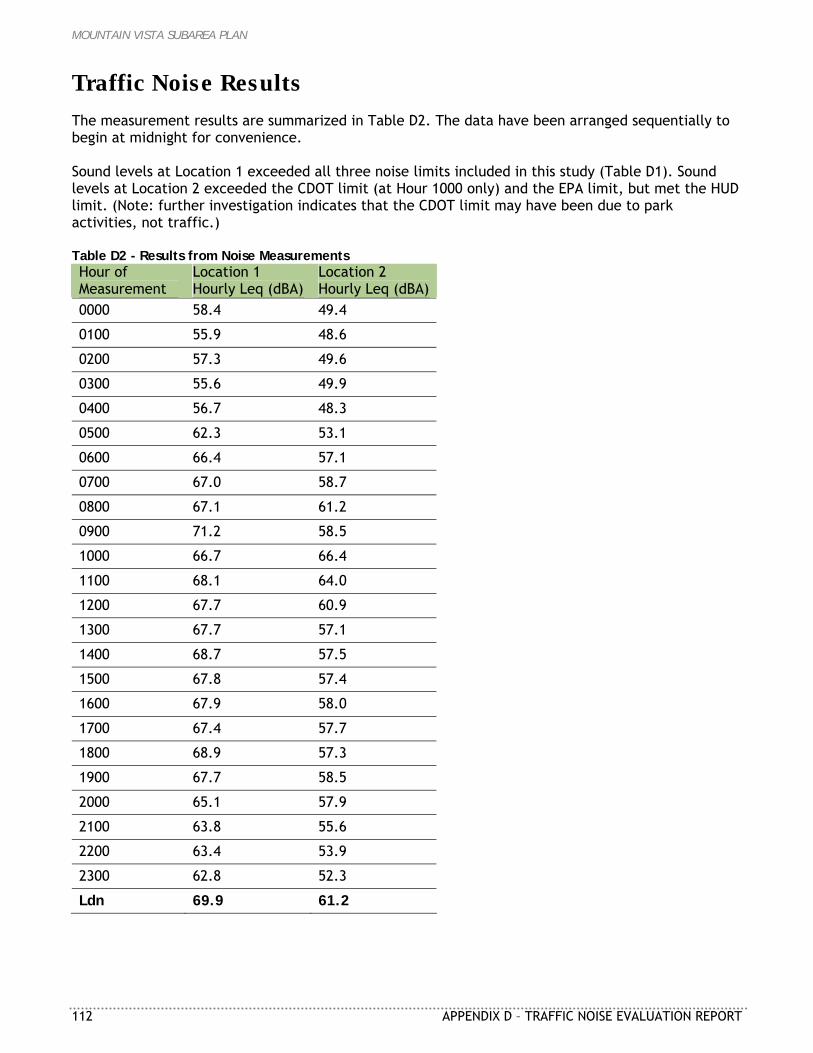
MOUNTAIN VISTA SUBAREA PLAN
112 APPENDIX D – TRAFFIC NOISE EVALUATION REPORT
Traffic Noise Results The measurement results are summarized in Table D2. The data have been arranged sequentially to begin at midnight for convenience. Sound levels at Location 1 exceeded all three noise limits included in this study (Table D1). Sound levels at Location 2 exceeded the CDOT limit (at Hour 1000 only) and the EPA limit, but met the HUD limit. (Note: further investigation indicates that the CDOT limit may have been due to park activities, not traffic.) Table D2 - Results from Noise Measurements Hour of Measurement
Location 1 Hourly Leq (dBA)
Location 2 Hourly Leq (dBA)
0000 58.4 49.4
0100 55.9 48.6
0200 57.3 49.6
0300 55.6 49.9
0400 56.7 48.3
0500 62.3 53.1
0600 66.4 57.1
0700 67.0 58.7
0800 67.1 61.2
0900 71.2 58.5
1000 66.7 66.4
1100 68.1 64.0
1200 67.7 60.9
1300 67.7 57.1
1400 68.7 57.5
1500 67.8 57.4
1600 67.9 58.0
1700 67.4 57.7
1800 68.9 57.3
1900 67.7 58.5
2000 65.1 57.9
2100 63.8 55.6
2200 63.4 53.9
2300 62.8 52.3
Ldn 69.9 61.2
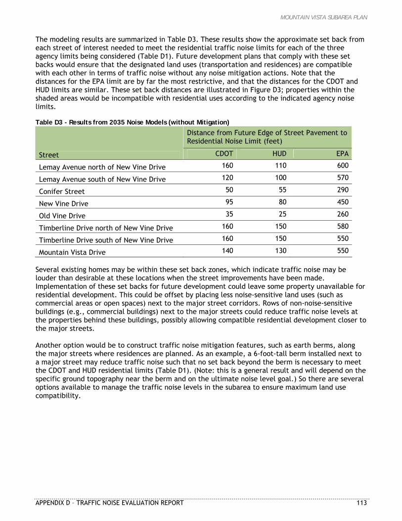
MOUNTAIN VISTA SUBAREA PLAN
APPENDIX D – TRAFFIC NOISE EVALUATION REPORT 113
The modeling results are summarized in Table D3. These results show the approximate set back from each street of interest needed to meet the residential traffic noise limits for each of the three agency limits being considered (Table D1). Future development plans that comply with these set backs would ensure that the designated land uses (transportation and residences) are compatible with each other in terms of traffic noise without any noise mitigation actions. Note that the distances for the EPA limit are by far the most restrictive, and that the distances for the CDOT and HUD limits are similar. These set back distances are illustrated in Figure D3; properties within the shaded areas would be incompatible with residential uses according to the indicated agency noise limits. Table D3 - Results from 2035 Noise Models (without Mitigation)
Distance from Future Edge of Street Pavement to Residential Noise Limit (feet)
Street CDOT HUD EPA
Lemay Avenue north of New Vine Drive 160 110 600
Lemay Avenue south of New Vine Drive 120 100 570
Conifer Street 50 55 290
New Vine Drive 95 80 450
Old Vine Drive 35 25 260
Timberline Drive north of New Vine Drive 160 150 580
Timberline Drive south of New Vine Drive 160 150 550
Mountain Vista Drive 140 130 550 Several existing homes may be within these set back zones, which indicate traffic noise may be louder than desirable at these locations when the street improvements have been made. Implementation of these set backs for future development could leave some property unavailable for residential development. This could be offset by placing less noise-sensitive land uses (such as commercial areas or open spaces) next to the major street corridors. Rows of non-noise-sensitive buildings (e.g., commercial buildings) next to the major streets could reduce traffic noise levels at the properties behind these buildings, possibly allowing compatible residential development closer to the major streets. Another option would be to construct traffic noise mitigation features, such as earth berms, along the major streets where residences are planned. As an example, a 6-foot-tall berm installed next to a major street may reduce traffic noise such that no set back beyond the berm is necessary to meet the CDOT and HUD residential limits (Table D1). (Note: this is a general result and will depend on the specific ground topography near the berm and on the ultimate noise level goal.) So there are several options available to manage the traffic noise levels in the subarea to ensure maximum land use compatibility.
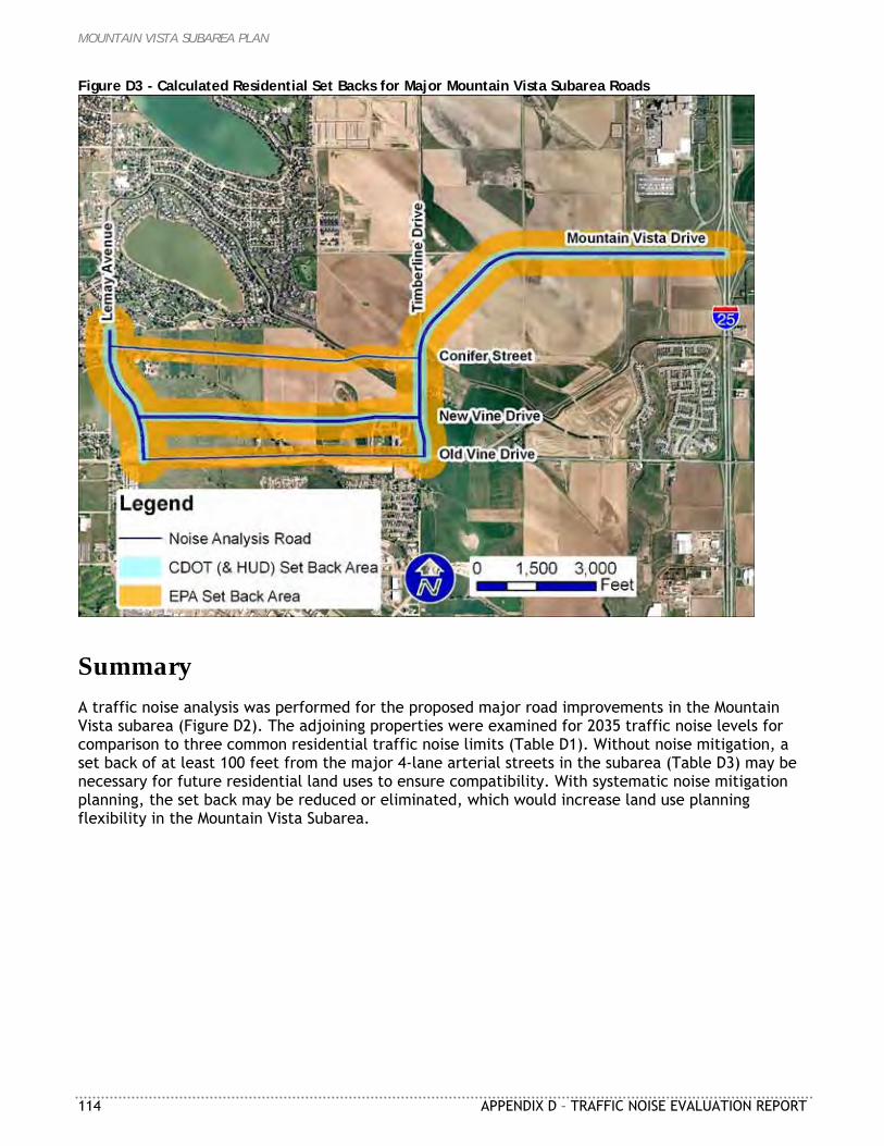
MOUNTAIN VISTA SUBAREA PLAN
114 APPENDIX D – TRAFFIC NOISE EVALUATION REPORT
Figure D3 - Calculated Residential Set Backs for Major Mountain Vista Subarea Roads
Summary A traffic noise analysis was performed for the proposed major road improvements in the Mountain Vista subarea (Figure D2). The adjoining properties were examined for 2035 traffic noise levels for comparison to three common residential traffic noise limits (Table D1). Without noise mitigation, a set back of at least 100 feet from the major 4-lane arterial streets in the subarea (Table D3) may be necessary for future residential land uses to ensure compatibility. With systematic noise mitigation planning, the set back may be reduced or eliminated, which would increase land use planning flexibility in the Mountain Vista Subarea.
MOUNTAIN VISTA SUBAREA PLAN
APPENDIX E – TRUCK BYPASS ROUTE ANALYSIS 115
A P P E N D I X E
TRUCK BYPASS ROUTE ANALYSIS Analysis Elements Summary Prepared by: City of Fort Collins Transportation Planning 250 North Mason Street Fort Collins, CO 80524 Revised: August 19, 2009 The variety of commercial, industrial, employment, and residential land uses is one aspect of updating the Mountain Vista Subarea Plan having widespread support. The project team plans for a street network to provide increased access and mobility to serve current and future land uses. Transportation related issues generated significant discussions throughout the update planning process, in particular, the concerns of some residents within the Lindenwood neighborhood of a potential de facto truck bypass connecting through the subarea. This staff analysis is in response to these concerns raised. A safe and effective transportation network is vital for all modes of travel including automobiles, trucks, bicycles, pedestrians, and transit. It is the responsibility of the project team to ensure these land uses are provided with a street network to serve them successfully from a safety, operational, and multimodal connectivity perspective. Over the past year, the project team has examined six land use and transportation alternatives. The street classifications and alignments on these alternatives have ranged from a series of sharp 90 degree turns to an almost straight connection from I-25 to College Avenue to the same streets currently shown on the Master Street Plan. Each alternative has been reviewed by City staff, project consultants, various Boards and Commissions, City Council, and hundreds of Fort Collins residents. The project team brought forward a Framework Plan that balancing all of the input received. As part of this planning process, some residents of the Lindenwood neighborhood expressed concerns about realigned Vine Drive acting as a de facto truck bypass route alternative to the SH 14/US 287 truck route. The project team has, and will continue to, address this concern. This analysis was prepared to address these concerns about a de facto truck bypass route. The City is not planning for a new truck route. City staff supports continued use of the existing SH 14/US 287 truck route. The project team has examined the different elements which may make a street more or less attractive to truck traffic. There are also recommendations on street design and enforcement for the extension of realigned Vine Drive so it does not attract increased through truck traffic. This analysis compares the existing SH 14/US 287 truck route to the proposed realigned Vine Drive/Mountain Vista Drive streets. The analysis starts at the intersection of Mulberry/I-25 and ends at the intersection of College Avenue and SH 1 (See attached transportation context map).
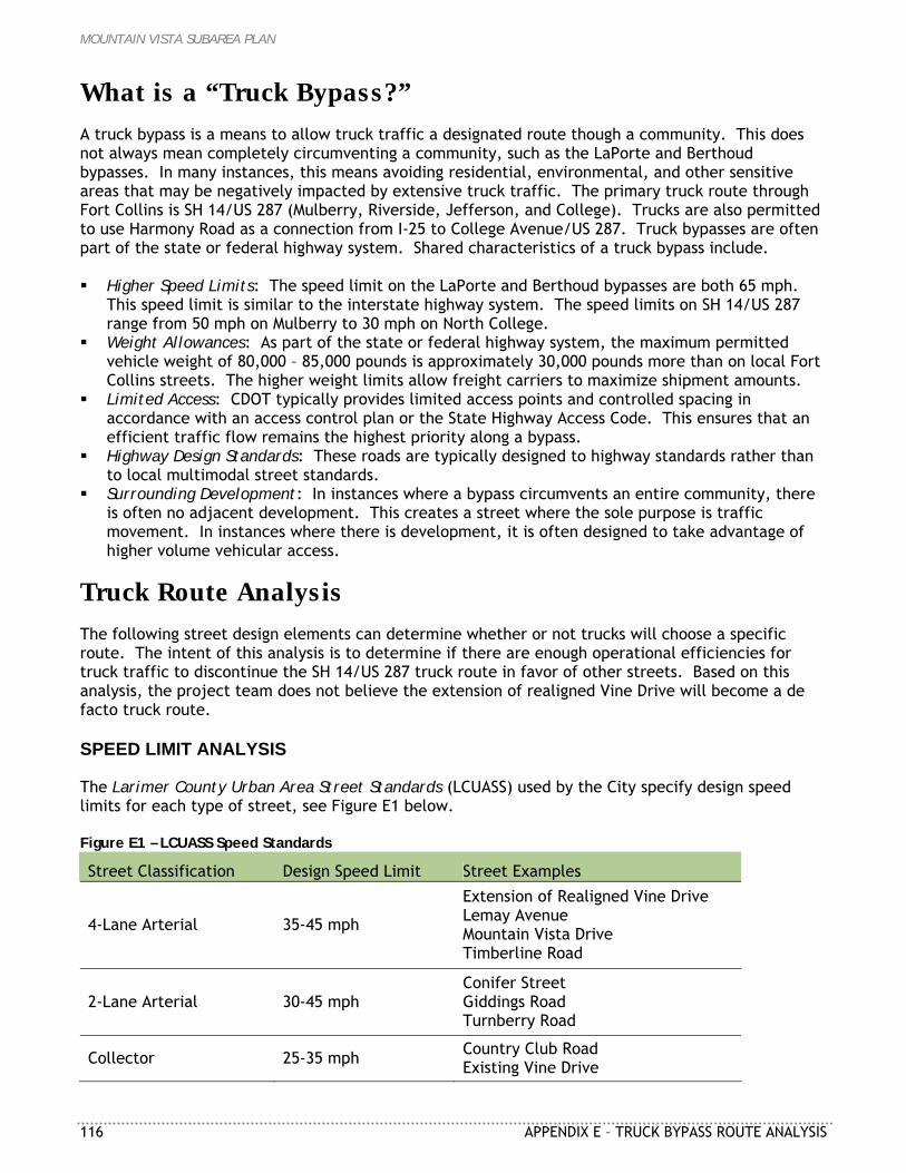
MOUNTAIN VISTA SUBAREA PLAN
116 APPENDIX E – TRUCK BYPASS ROUTE ANALYSIS
What is a “Truck Bypass?” A truck bypass is a means to allow truck traffic a designated route though a community. This does not always mean completely circumventing a community, such as the LaPorte and Berthoud bypasses. In many instances, this means avoiding residential, environmental, and other sensitive areas that may be negatively impacted by extensive truck traffic. The primary truck route through Fort Collins is SH 14/US 287 (Mulberry, Riverside, Jefferson, and College). Trucks are also permitted to use Harmony Road as a connection from I-25 to College Avenue/US 287. Truck bypasses are often part of the state or federal highway system. Shared characteristics of a truck bypass include. Higher Speed Limits: The speed limit on the LaPorte and Berthoud bypasses are both 65 mph.
This speed limit is similar to the interstate highway system. The speed limits on SH 14/US 287 range from 50 mph on Mulberry to 30 mph on North College.
Weight Allowances: As part of the state or federal highway system, the maximum permitted vehicle weight of 80,000 – 85,000 pounds is approximately 30,000 pounds more than on local Fort Collins streets. The higher weight limits allow freight carriers to maximize shipment amounts.
Limited Access: CDOT typically provides limited access points and controlled spacing in accordance with an access control plan or the State Highway Access Code. This ensures that an efficient traffic flow remains the highest priority along a bypass.
Highway Design Standards: These roads are typically designed to highway standards rather than to local multimodal street standards.
Surrounding Development: In instances where a bypass circumvents an entire community, there is often no adjacent development. This creates a street where the sole purpose is traffic movement. In instances where there is development, it is often designed to take advantage of higher volume vehicular access.
Truck Route Analysis The following street design elements can determine whether or not trucks will choose a specific route. The intent of this analysis is to determine if there are enough operational efficiencies for truck traffic to discontinue the SH 14/US 287 truck route in favor of other streets. Based on this analysis, the project team does not believe the extension of realigned Vine Drive will become a de facto truck route. SPEED LIMIT ANALYSIS The Larimer County Urban Area Street Standards (LCUASS) used by the City specify design speed limits for each type of street, see Figure E1 below. Figure E1 – LCUASS Speed Standards
Street Classification Design Speed Limit Street Examples
4-Lane Arterial 35-45 mph
Extension of Realigned Vine Drive Lemay Avenue Mountain Vista Drive Timberline Road
2-Lane Arterial 30-45 mph Conifer Street Giddings Road Turnberry Road
Collector 25-35 mph Country Club Road Existing Vine Drive
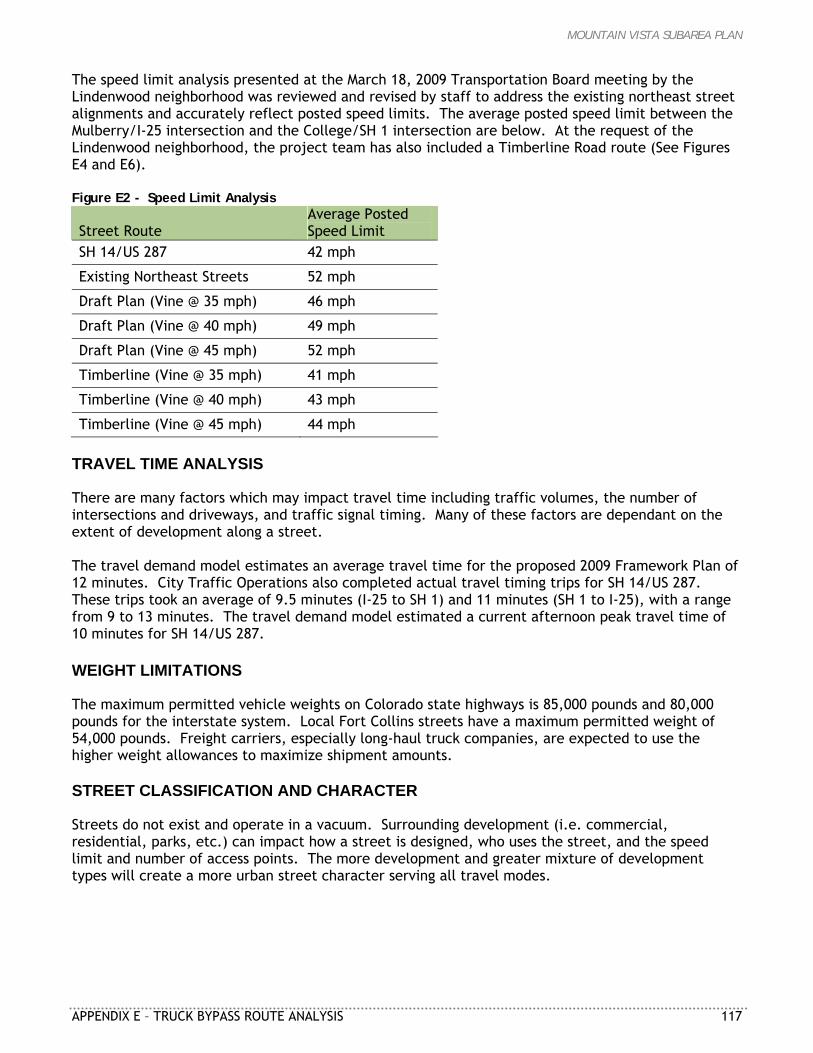
MOUNTAIN VISTA SUBAREA PLAN
APPENDIX E – TRUCK BYPASS ROUTE ANALYSIS 117
The speed limit analysis presented at the March 18, 2009 Transportation Board meeting by the Lindenwood neighborhood was reviewed and revised by staff to address the existing northeast street alignments and accurately reflect posted speed limits. The average posted speed limit between the Mulberry/I-25 intersection and the College/SH 1 intersection are below. At the request of the Lindenwood neighborhood, the project team has also included a Timberline Road route (See Figures E4 and E6). Figure E2 - Speed Limit Analysis
Street Route Average Posted Speed Limit
SH 14/US 287 42 mph
Existing Northeast Streets 52 mph
Draft Plan (Vine @ 35 mph) 46 mph
Draft Plan (Vine @ 40 mph) 49 mph
Draft Plan (Vine @ 45 mph) 52 mph
Timberline (Vine @ 35 mph) 41 mph
Timberline (Vine @ 40 mph) 43 mph
Timberline (Vine @ 45 mph) 44 mph TRAVEL TIME ANALYSIS There are many factors which may impact travel time including traffic volumes, the number of intersections and driveways, and traffic signal timing. Many of these factors are dependant on the extent of development along a street. The travel demand model estimates an average travel time for the proposed 2009 Framework Plan of 12 minutes. City Traffic Operations also completed actual travel timing trips for SH 14/US 287. These trips took an average of 9.5 minutes (I-25 to SH 1) and 11 minutes (SH 1 to I-25), with a range from 9 to 13 minutes. The travel demand model estimated a current afternoon peak travel time of 10 minutes for SH 14/US 287. WEIGHT LIMITATIONS The maximum permitted vehicle weights on Colorado state highways is 85,000 pounds and 80,000 pounds for the interstate system. Local Fort Collins streets have a maximum permitted weight of 54,000 pounds. Freight carriers, especially long-haul truck companies, are expected to use the higher weight allowances to maximize shipment amounts. STREET CLASSIFICATION AND CHARACTER Streets do not exist and operate in a vacuum. Surrounding development (i.e. commercial, residential, parks, etc.) can impact how a street is designed, who uses the street, and the speed limit and number of access points. The more development and greater mixture of development types will create a more urban street character serving all travel modes.
MOUNTAIN VISTA SUBAREA PLAN
118 APPENDIX E – TRUCK BYPASS ROUTE ANALYSIS
AIR QUALITY The project team prepared an air quality analysis comparing the proposed 2009 Framework Plan and the existing 1999 Framework Plan and Master Street Plan street networks. This analysis included estimates of the annual amount of greenhouse gases and ozone generated within the Mountain Vista Subarea, Fort Collins, and the North Front Range. The estimated amount of greenhouse gases and ozone generated at all three levels is the same between the 1999 and proposed 2009 Framework Plans. The analysis does not distinguish air quality impacts by vehicle type. NOISE The project team prepared an analysis to determine noise impacts of arterial streets, particularly the extension of realigned Vine Drive. Truck traffic is factored into the analysis as part of the projected traffic levels for the subarea. Two different standards were used in this analysis: a 55db US Environmental Protection Agency standard and a 66db Colorado Department of Transportation standard. Figure E5 highlights the areas that would exceed these standards. It should be noted the analysis is based on a “flat earth” assumption (i.e. no topography, no development, no landscaping, etc). Fencing, development patterns, and landscaping would all work to reduce the noise impact. ACCESS CONTROL Both City of Fort Collins and Colorado Department of Transportation (CDOT) adopted the SH 14/US 287 Access Control Plan (available at fcgov.com/transportationplanning/downloads). This document specifies the location and type of all access points along the corridor. Any amendments to the plan must be jointly approved by the City and CDOT. All of the streets in the Mountain Vista area, with the exception of I-25, will be under Fort Collins jurisdiction. Access along these streets is determined by Section 9.2 of the Larimer County Urban Area Street Standards. The standards allow for more frequent access points and turning movements along a street as compared to the state highways within Fort Collins. With additional access points along arterial streets, the result is reduced traffic speeds and delays at intersections. This can slow traffic and requires additional awareness of traffic conditions and delays for through truck traffic. INTERSECTIONS The SH 14/US 287 Access Control Plan identifies 16 existing plus 2 future signalized intersections. The project team estimates there are 12-13 potential signalized intersections along the realigned Vine Drive, Mountain Vista, and College arterial streets (See Figure E6). This does not include any additional controlled intersections which may be required at the time of development. There will likely be many more controlled and uncontrolled intersections along the local streets. RAILROAD CROSSINGS Both the Union Pacific Railroad (UPRR) and Burlington Northern Santa Fe (BNSF) railroad lines serve the northeast portion of Fort Collins. This includes a shared railroad switching yard along the existing Vine Drive between Lemay Avenue and Timberline Road, and a UPRR switching yard along Riverside Avenue between Mulberry Street and Lincoln Avenue. Both are secondary lines providing additional capacity to other BNSF and UPRR railroad facilities in Weld County. The railroad tracks along Riverside/Jefferson are owned by UPRR and operated by Great West Railway (GWR). GWR provides train car switching between UP switching yards north of Fort Collins and in south Fort Collins. The typical train traffic is one car per day with a limited number of train cars, five days per week.

MOUNTAIN VISTA SUBAREA PLAN
APPENDIX E – TRUCK BYPASS ROUTE ANALYSIS 119
The railroad tracks along Mason Street/Vine Drive are owned by the BNSF and operated by GWR and BNSF. The line operates seven days per week and the number of daily trains has fluctuated with the economy. Approximately 6-8 trains per day are utilizing the railway currently, with a high of 10-12 trains per day in the past. The mainline UPRR/BNSF line through Greeley serves upwards of 40 trains per day serving users in Cheyenne, Denver, and eastern Colorado. Although there is minimal train traffic along these lines, trains can still create a negative impact on several intersections along the SH 14/US 287 truck route. This includes the Mulberry and Riverside (UPRR railroad tracks) and College and Willow (BNSF railroad tracks) intersections. If traffic has to wait at a railroad crossings, travel times are increased and average speeds reduced. Despite this negative impact, the project team does not believe there is significant enough delays for truck traffic to abandon the SH 14/US 287 truck route. There are many positive aspects of the existing truck route providing greater operational efficiencies.
Analysis and Street Design Supports the SH 14/US 287 Truck Route The project team will plan for a street network providing access and mobility to current and future land uses. The street network will serve all modes of travel, including trucks, needing access to the commercial, industrial, employment, and residential land uses proposed in the framework plan. The extension of realigned Vine Drive will provide a key arterial street connection for northeast Fort Collins and the Mountain Vista Subarea. It would be irresponsible of the project team to not provide a safe and efficient transportation network to support the existing and future land uses in the Mountain Vista Subarea. Based on this analysis, the project team does not believe realigned Vine Drive will be a de facto truck bypass route. There are not large enough speed, travel time, or safety efficiencies gained for truck traffic to discontinue use of the SH 14/US 287 truck route. The existing truck route provides a safe and predictable travel environment for trucks including CDOT controlled access, signalized intersections, and smooth traffic flows. In addition, the SH 14/US 287 truck route permits vehicle weights up to 30,000 pounds more than on local Fort Collins streets. As part of updating the Mountain Vista Subarea Plan, the project team suggests several street design elements to help discourage long-haul through truck traffic along the proposed arterial streets. Final street design and a traffic impact study will occur concurrently with the development review process. This would give both the public and City the ability to comment on the street design. The recommended design elements would not compromise the function and efficiency of the overall street network. Travel Lane Width: The City street standards include a 12-foot travel lane width for 4-lane
arterial streets. City Traffic Engineer indicated an 11-foot travel lane would be acceptable from a safety perspective. A narrower travel lane would encourage lower speeds and a safer travel environment.
Intersection Controls: City policy states all types of intersection controls, including roundabouts,
must be considered and evaluated. The preferred intersection control is based on providing a safe and efficient transportation network to serve surrounding development and traffic volumes. A roundabout would be designed to accommodate all types of traffic, including trucks. However, the slower speeds and traffic movements associated with a roundabout would help discourage through truck traffic. City of Cheyenne currently plans a roundabout on an arterial street, though it will accommodate trucks.
MOUNTAIN VISTA SUBAREA PLAN
120 APPENDIX E – TRUCK BYPASS ROUTE ANALYSIS
Street Design Speed: The design speed of new streets is adjustable in conjunction with the desired posted speed limits. Portions of realigned Vine Drive, Timberline Road, and Mountain Vista Drive could have lower posted and design speed limits. However, there must be an adequate street design speed to ensure traffic safety as determined by a City Traffic Engineer. Lower speed limits are recommended along the Community Commercial District, community park, Poudre School District site. Other locations may be determined as development occurs based on traffic impact studies.
Local Street Traffic Calming: The City already installs a significant amount of traffic calming
devices on collector-level and local streets including raised crosswalks, stop signs, and pedestrian crossing signage. Traffic calming devices are intended to reduce cut-through traffic on neighborhood streets.
Signage: The City and CDOT have the ability to post truck route and vehicle weight limitation
signage. The project team recommends posting truck route signage along SH 14/US 287, and vehicle weight limitation signage along major arterial streets off of I-25.
In the event through truck traffic does begin using realigned Vine Drive instead of the SH 14/US 287 truck route, the City would have several options: The City can work with local and state law enforcement agencies to enforce weight restrictions
on local roadways. CDOT and the Colorado State Highway Patrol will occasionally conduct mobile truck weigh
stations to ensure compliance with weight restrictions. This approach would be similar to speed limit enforcement within school zones.
The City can also post weight restriction and other signage to increase awareness of local and
state truck traffic regulations. This could be done along both the SH 14/US 287 truck route and realigned Vine Drive.
The project team was asked if all truck traffic could be banned along realigned Vine Drive. The
local street network is intended to serve adjacent commercial, industrial, employment, and residential land uses and all vehicle types, including trucks. The project team cannot responsibly support prohibiting trucks on local streets.
In summary, the project team believes long-haul and inter-regional truck traffic will continue to use the existing SH 14/US 287 truck route as the preferred route through Fort Collins. There is not enough operational efficiency for trucks to discontinue use of the existing truck route in favor on realigned Vine Drive.
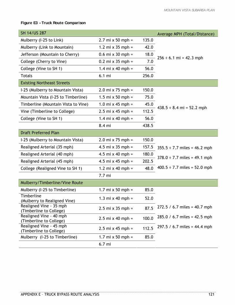
MOUNTAIN VISTA SUBAREA PLAN
APPENDIX E – TRUCK BYPASS ROUTE ANALYSIS 121
Figure E3 – Truck Route Comparison SH 14/US 287 Average MPH (Total/Distance) Mulberry (I-25 to Link) 2.7 mi x 50 mph = 135.0
Mulberry (Link to Mountain) 1.2 mi x 35 mph = 42.0
Jefferson (Mountain to Cherry) 0.6 mi x 30 mph = 18.0
College (Cherry to Vine) 0.2 mi x 35 mph = 7.0
College (Vine to SH 1) 1.4 mi x 40 mph = 56.0
Totals 6.1 mi 256.0
256 ÷ 6.1 mi = 42.3 mph
Existing Northeast Streets
I-25 (Mulberry to Mountain Vista) 2.0 mi x 75 mph = 150.0
Mountain Vista (I-25 to Timberline) 1.5 mi x 50 mph = 75.0
Timberline (Mountain Vista to Vine) 1.0 mi x 45 mph = 45.0
Vine (Timberline to College) 2.5 mi x 45 mph = 112.5
College (Vine to SH 1) 1.4 mi x 40 mph = 56.0
8.4 mi 438.5
438.5 ÷ 8.4 mi = 52.2 mph
Draft Preferred Plan
I-25 (Mulberry to Mountain Vista) 2.0 mi x 75 mph = 150.0
Realigned Arterial (35 mph) 4.5 mi x 35 mph = 157.5
Realigned Arterial (40 mph) 4.5 mi x 40 mph = 180.0
Realigned Arterial (45 mph) 4.5 mi x 45 mph = 202.5
College (Realigned Vine to SH 1) 1.2 mi x 40 mph = 48.0
7.7 mi
355.5 ÷ 7.7 miles = 46.2 mph 378.0 ÷ 7.7 miles = 49.1 mph 400.5 ÷ 7.7 miles = 52.0 mph
Mulberry/Timberline/Vine Route
Mulberry (I-25 to Timberline) 1.7 mi x 50 mph = 85.0 Timberline (Mulberry to Realigned Vine) 1.3 mi x 40 mph = 52.0
Realigned Vine - 35 mph (Timberline to College) 2.5 mi x 35 mph = 87.5
Realigned Vine - 40 mph (Timberline to College) 2.5 mi x 40 mph = 100.0
Realigned Vine - 45 mph (Timberline to College) 2.5 mi x 45 mph = 112.5
Mulberry (I-25 to Timberline) 1.7 mi x 50 mph = 85.0
6.7 mi
272.5 / 6.7 miles = 40.7 mph 285.0 / 6.7 miles = 42.5 mph 297.5 / 6.7 miles = 44.4 mph
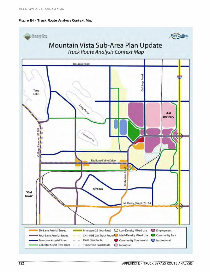
MOUNTAIN VISTA SUBAREA PLAN
122 APPENDIX E – TRUCK BYPASS ROUTE ANALYSIS
Figure E4 - Truck Route Analysis Context Map
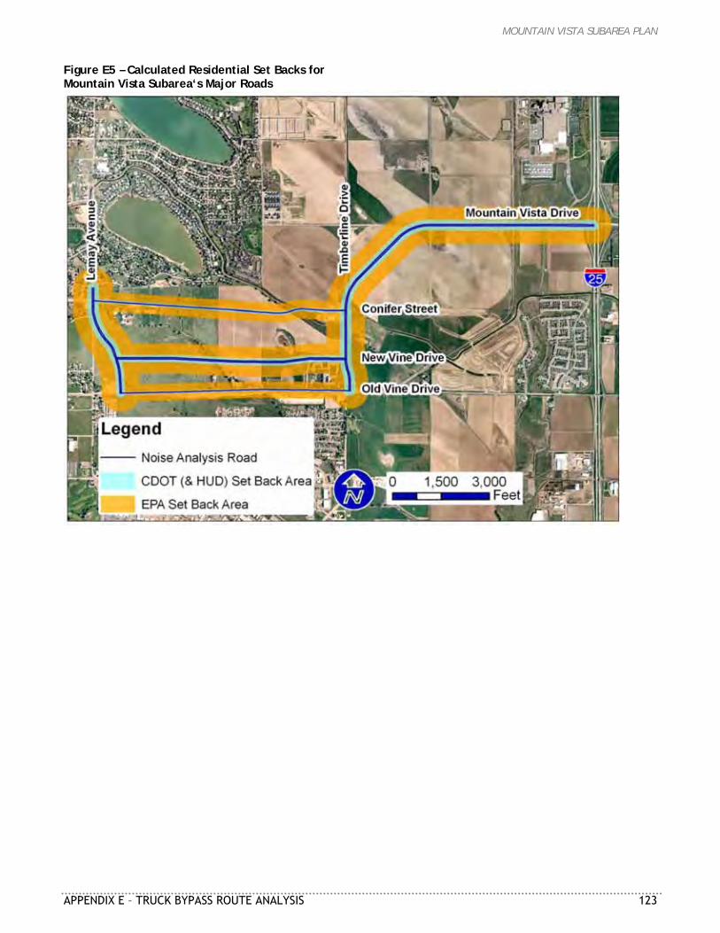
MOUNTAIN VISTA SUBAREA PLAN
APPENDIX E – TRUCK BYPASS ROUTE ANALYSIS 123
Figure E5 – Calculated Residential Set Backs for Mountain Vista Subarea‘s Major Roads
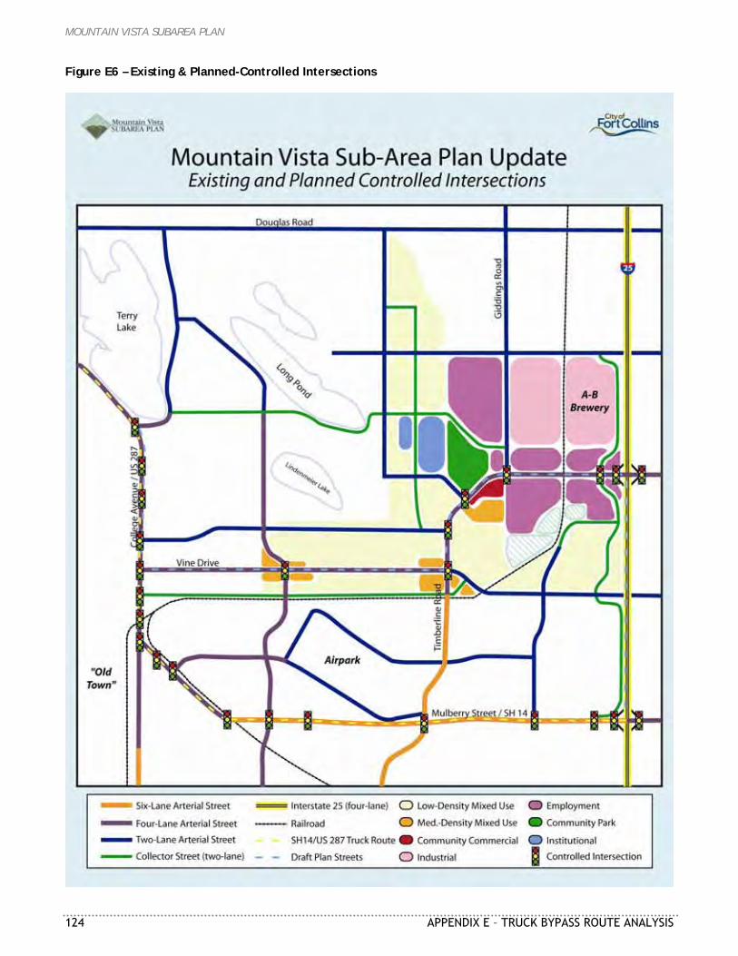
MOUNTAIN VISTA SUBAREA PLAN
124 APPENDIX E – TRUCK BYPASS ROUTE ANALYSIS
Figure E6 – Existing & Planned-Controlled Intersections